Abstract
Torrents play an essential role in water resources through rainfall in arid to semi-arid mountainous regions, serving large populations worldwide, and are also crucial in maintaining the downstream environment. The natural flows (floods, ephemeral flows) in arid hill regions result in potential hydrological fluctuations caused by climate change. However, the feasibility of eventual storage in remote hilly catchments would force a more sudden change. The current study was conducted in the lower part of the Khirthar National Range in the Sindh province of Pakistan, with the aim to explore spatial runoff storage sites for sustainable development to mitigate the impacts of climate change in arid areas. In total, 83 years of precipitation data were used to estimate water availability, along with satellite imagery for LULC pre- and post-monsoon conditions, delineation of watersheds, and identification of potential runoff storage locations and return periods, using Remote Sensing (RS)/Geographical Information System (GIS) 10.5.1, HEC-HMS 3.1, and Origin Pro 9.0 for statistical approaches. The model delineated two potential watersheds: Goth Sumar, covering an area of 61.0456 km2, wherein ten cascading reservoirs were identified, and Goth Baro, covering an area of 14,236 km2, wherein two cascading reservoirs were identified. Different storage capacities were determined for the cascade-type reservoirs. The maximum live volumetric potential storage of the reservoirs varies from 0.25 to 1.32 million cubic meters (MCM) in the villages of Baro and Sumar. The return periods have been estimated at 5, 10, 20, 25, 50, and 75 years, corresponding to 12.35, 16.47, 21.43, 21.72, 25.21, and 40.53 MCM for Goth Sumar, while Goth Baro’s storage capacity has been estimated at 2.88, 3.84, 5.00, 5.06, 5.88, and 9.45 MCM, respectively. All results obtained were authenticated using accuracy assessment, validation, and sensitivity analysis. The proposed potential storage sites were recommended for a planning period of five years. The live storage capacity of the identified cascade reservoirs can be improved by raising the marginal banks and developing the spillways to control inlet and outlet flow in order to maintain internal pressure on the reservoir banks. The stored water can be used for climate-friendly agricultural activities to increase crop production and productivity. The proposed study area has extensive experience with flood irrigation systems and rainwater harvesting to sustain agriculture due to rainfall being the only water resource (WR) in the region. However, the study area has enormous potential for surface runoff WRs, especially during the rainy season (monsoon); the current 2022 monsoon is showing flooding. The modeling approaches of Remote Sensing, GIS, and HEC-HMS play an important role in delineating watershed areas, developing hydrographs, and simulating water availability for different return periods by minimizing cost and time.
1. Introduction
Water reservoirs lead to sustainable development in the water and agriculture sector for the enhancement of livelihood and socioeconomic conditions [1,2]. Many watersheds create solitary or cascade reservoirs. The active management of reservoirs sustains the apportionment of water resources, which mitigates the regional water scarcity problems, manages flood hazard situations, and leads to integrated water resource management [3,4,5]. Climatic variations have led to the importance and need for water-harvesting techniques for agriculture practices, which vary according to the physiography of the land cover and the magnitude of the precipitation [6,7].
Global warming represents a threat to hydrological cycles [8,9] and geomorphological processes [10], and has similar adverse effects on water resource management, especially in the watersheds of hilly tracts. Previous plans have become no longer feasible in the changing environment. Accordingly, adaptive operational management rules have been widely developed to mitigate the adverse impacts of climate change [11,12]. Abera and Shumate [13] suggested that cascade reservoirs may play an important role in improving power generation and water supply. The ideal operational management of cascade reservoirs under the paradigm of global warming is a significant issue in the planning and management of water resources because of the increasing population and rapid economic growth.
Globally, agricultural practices increased tremendously in the second half of the 20th century [14,15]. Surface and groundwater availability has widely been increased using integrated interventions in watersheds, leading to an increase in agricultural productivity, an improvement of people’s socio-economic conditions, and a reduced migration rate [3,4]. Agriculture is the backbone of Pakistan, which contributes to 19.5% of GDP, 42% of labor force, 64% of export earnings, and 62% of people’s livelihoods (Economic Survey, 2016–2017). Pakistan is using about 90% of its water for the agriculture sector. In the present study area, a large part of WR potential is not being evaluated or developed to be used profitably by the local communities, instead being dumped as waste in the Arabian Sea through the Indus River. In order to fully exploit the economic potential of arid and semi-arid regions, the conservation and sustainable management of their WRs are of paramount importance [16]. The country is under threat of water scarcity [17]; water availability has decreased from 5260 to 935 m3/capita over the last 70 years [18]. The gradual increase in the population of the country is the main factor for the reduction in water availability per capita. The growing population may be controlled by introducing national-level programs with the coordination of the stakeholders [19]. Researchers have projected that the figure will decline to 500 m3/capita if immediate actions are not taken at the national level [18]. The water requirement per person per day for domestic chores is about 50 liters, whilst 2600 to 5300 liters is required per person per day for food production [17]. Sullivan et al. [20] revealed in their study that Pakistan is a water-scarce country, and food security is directly connected to water security; indeed, the aforementioned figures indicate that about 50–100 times more water is required for food production as compared to domestic chores per person. The irrigated area of Pakistan contributes to about 90% of agricultural food production, with the balance contributed by dryland rainwater-harvesting regions with minimal rainfall (World Bank, 2006) [21]. The situation urgently requires major investment in the water sector.
Wide-ranging hydrological studies have been conducted to examine the natural water storage, and evaluating sites for irrigation purposes is the key to strengthening dryland farming [22]. Dryland agriculture practices are threatened by uncertainties in spatial-temporal water accessibility and crop yield. Forecasting at the field scale remains a great challenge [23]. A limited area of dryland is suitable for hosting a supplementary irrigation system with water-harvesting techniques, through enhancement of the micro-level storage reservoirs for the limited population [3]. The main benefits of using minor reservoirs include maximizing the quantity of reservoirs and ensuring local water availability. Indeed, they are considered to be the only economical and feasible way to supply more water for various purposes in order to improve economic development and reduce poverty [24].
Surprisingly, Pakistan has the fourth-highest rate of water consumption in the world. After 2005, the reports reveal that the availability of water has reduced to below 1000 m³/capita, which presents a major challenge for Pakistan, as no other country’s economy is more water demanding (UNDP 2016) [25]. Water has an economic worth of about $70 billion, which is thrown into the sea annually due to the unavailability of appropriate water storage capacity. A water-starved nation, which has a foreign reserve of just $20 billion, cannot tolerate wasting water in the sea without using it [26]. Pakistan has experienced many erratic droughts and extreme floods. The Sindh province had its worst droughts in the years 1871, 1881, 1899, 1931, 1947, and 1999. A particularly severe period of drought occurred at the national level in 1999–2000, extending to 2002, which severely influenced arid, precipitation-dependent regions, especially the south-western hilly track region of the Indus Basin in the Sindh province of Pakistan, well known as Kohistan [26].
The Kohistan region, extending about 310 km from Baluchistan to Sindh, is a poorly developed area in terms of harnessing its WRs [27], with scant rainfall and a scattered population subsisting on an average income below the poverty level (under $1/day) [28]. Many torrents in the region feed into water bodies, such as Hamal, Manchar, and Keenjhar Lake, located in the foothills. The Kohistan region has vast water resource potential, which is neither being assessed nor developed for productive utilization by the existing people, instead being left to run off to the Arabian Sea as waste. To fully exploit the economic potential of arid and semi-arid regions, conservation and sustainable management of its water resources are of prime importance [16,27].
Torrential floods are extremely destructive natural disasters, causing enormous damage to the agricultural system, people’s livelihoods, and other human activities. In particular, reservoirs must become more resilient to such damage. However, inconsistency in the intensity of precipitation patterns increases the risk of flooding. Managed reservoir infrastructures and climatic forecasting systems are needed in the current era. In light of this, the present study was designed to investigate potential spatial runoff locations for cascade reservoirs.
Various studies on integrated approaches have been conducted worldwide. Cascading reservoirs are used to manage dangerous flooding situations, mitigate the effects of climate change, regulate water supply and power generation, change crop patterns, improve the ecosystem, and create a more friendly environment [3,5,10,18,23,29,30,31,32,33].
The present study aims to investigate the spatial identification of cascade reservoirs for maximizing water availability through modeling approaches, for the sustainable development of feasible sites in the study area. The people in the study area live on their small pieces of land and carry out farming practices through spate irrigation and rainwater-harvesting systems. During the dry spells, the local people have no food staples through the farming base, which increases poverty in the study area, so the people migrate with their animals to the irrigated areas of the Indus River. The sustainability of the local people is our prime aim; to this end, the present study was designed to explore spatial runoff storage sites for water harvesting and mitigation of climate change’s impact on their sustainable development, in order to reduce poverty and improve the people’s socioeconomic conditions.
2. Materials and Methods
2.1. Study Area
The proposed study area is a subpart of the lower Kohistan arid mountainous region situated in the Khirthar National Range, Sindh Province of Pakistan. It is located between 26°6′59.36″ and 24°58′7.7″ N and between 67°16′16.49″ and 67°56′30.98″ E, over an area of 5273.25 km2. The study area is hilly, with torrents combining to drain into their catchments. There are steep, rugged, relatively barren, and bald hills, with high relief and a dendritic form of drainage. The climate in the region is relatively humid, with bearable summers and mild winters. The mean annual precipitation is in the range of 150–250 mm, and the wet months are July to September. The minimum and maximum temperatures are −1.00 and 52.00 °C, corresponding to winter and summer, respectively. The average wind velocity is 10.00 km/h (PARC. 2010). The humidity ranges from 30% to 85%. The evaporation rate varies spatially, ranging from 2000 to 2100 mm annually. The torrent beds and valleys have very high infiltration rates and good permeability, with intensive rains disappearing in a matter of hours(Figure 1).
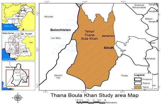
Figure 1.
Layout map of the study area.
2.2. Data Collection and Preparation
The precipitation data were collected from various sources, including the Pakistan Meteorological Department, Surface Water Hydrology (Water and Power Development Authority), and the Rod-Kohi/Spate irrigation project Dadu Component (Pakistan Agricultural Research Council). When updating the precipitation dataset, it was found to be missing some data. The missing precipitation data were estimated using statistical analysis, and then the dataset was updated again (Table 1). We integrated meteorological data covering 83 years (from 1933 to 2013, daily basis) with hydrological modeling (HEC-HMS version 3.3) over the study area.

Table 1.
Source and satellite image information accumulation and preparation.
Remote sensing was used to download seven satellite images of Landsat 5 and Landsat 8 (corresponding to 2010 and from 2013 to 2018, respectively), and the Digital Elevation Model (DEM) was used through the USGS earth explorer. The images covering path 152–153, row 42–43 in the study area for September for the respective years had an image resolution of 30 × 30 (Table 1). Images for extreme floods, below average precipitation (dry), and average precipitation were utilized, corresponding to 2010, 2013–2013, and 2016–2018, respectively. Arc-GIS 10.5.1 was used for geo-processing the image classification, and HEC-Geo-HMS was utilized for the delineation of the watersheds in the study area. Landsat image data were compared with data pertaining to the real situation at ground level, which were recorded in the primary data collection and GPS dataset. HEC-HMS 3.3 was used for land surface hydrological model simulations. Precipitation data were used to develop a hydrograph and determine water availability in the study area at 5, 10, 20, 25, 50, and 75 years for the different return periods. The stepwise details of the methodology are elaborated in Figure 2. Google Earth Pro was used to delineate the shape files of the study area. The detail of the units are described in detail in the each narration.
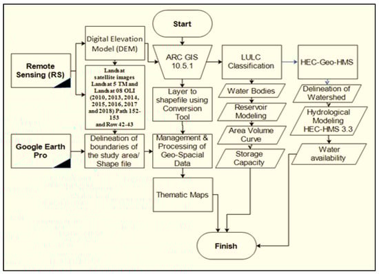
Figure 2.
Flow Chart of the Methodology.
The collected satellite images were orthorectified against data from the 1984 World Geodetic System (WGS-1984) and zones 42 and 43 of the Universal Transverse Mercator projected coordinate system. The sensors used in the 2010 image were Thematic Mapper sensors, whilst those used in the 2013 to 2018 images were Enhanced Thematic Mapper (ETM+) sensors. All sets of images have the same 30 m resolution and are in separate spectral bands. Color Composite Images (CCI) of all sets with a minimum of eight spectral bands have been created. We formed mosaics comprising both scenes of each year’s image in order to obtain complete sets of images for the study area. The supervised image classification method was applied to each set of mosaics, drawing five classes from each image. These classes are barren land, settlement, vegetation, water bodies, and wetland. Further geo-processing work has been conducted on the water bodies, revealing the potential runoff storage sites for the current study.
2.3. Accuracy Assessment, Validation, and Sensitivity Analysis
The focus of the current study was an accuracy assessment using techniques in which random points on the classified layer were populated by ArcGIS 10.5.1. The image was corrected accordingly by awarding 50 points per class. We validated these points in Google Earth Pro by converting them to Kml format using the conversion tool. The GPS training data were used to verify the accuracy of the LULC detailed map from Google Earth Pro by overlaying the original image of each year. The Google Earth Pro image was converted to a shapefile for accuracy assessment using ArcGIS. Finally, we populated the confusion matrix with points (random, GPS trot, and training points) using the Spatial Analyst tool. In addition, the confusion matrix was estimated using statistical techniques. The SCS-CN method is an empirical technique for estimating precipitation runoff volume from precipitation in small watersheds, and CN is an empirically derived parameter used to calculate the direct runoff from a precipitation event. CN depends on the soil type, its condition, and the land use and land cover (LULC) of an area. Precise knowledge of these factors was not available for the study area; therefore, a set of values was selected to analyze the sensitivity of the model to changing CN values (Soomro et al., 2019).
3. Results
As described in the methodology, the present study was conducted in two different locations under the subpart of the Khirthar National Range shown in Figure 1. The maps were delineated for spatial and temporal image analysis of Land Use and Land Cover, and were categorized into five classes accordingly. During this process, we focused on the core objective of the study: to investigate appropriate locations for potential runoff storage. Data of water bodies were obtained over a diverse temporal area for the study period, corresponding to 2010 and 2013–2018. The classification results for the water bodies are illustrated herein. The delineated maps in Figure 3 and Figure 4, extracted from the image for 2010, show extreme wet spells; indeed, 2010 ranks as the highest flood year from the dataset of 81 years. The results reveal that water bodies reflect weather conditions based on variations in precipitation patterns.
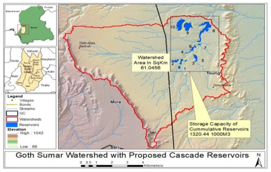
Figure 3.
Cascade reservoir of Goth Sumar.
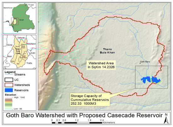
Figure 4.
Cascade reservoir of Goth Baro.
The delineated map in Figure 3, located in the Union Council Mole, at Goth Sumar Watershed, covers an area of 61.0456 km2. The map shows that the cascade reservoir contains ten connected storage points. The outlets are shown with double yellow lines, with outlets through the development of spillways. The cumulative storage capacity of the reservoir is estimated at 1.320 Million Cubic Meters (MCM) (Figure 3 and Table 2). The water availability is estimated at 12.35, 16.47, 21.43, 21.71, and 40.52 MCM, corresponding to 5, 10, 20, 25, and 75 years for the different return periods, respectively (Figure 5a). Graphical representations of the area volume curve for the Goth Sumar cascade reservoir are shown in Figure 6a,l. The figures illustrate the area in acres, elevation in ft, and live storage in acre-ft. Figure 6i shows that Reservoir 9 has the minimum storage capacity (700 acre-ft), covering 80 acres of land at an elevation of 822 ft. Meanwhile, Figure 6j shows that Reservoir 10 has the maximum storage (about 135 acre-ft), covering 33 acres of land at an elevation of 1095 ft.
Table 2.
Water availability and storage capacity.
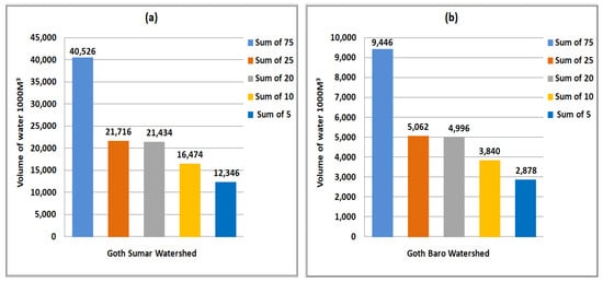
Figure 5.
Graph of water availability for various return periods: (a) Goth Sumar and (b) Goth Baro.
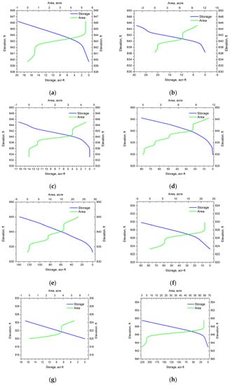
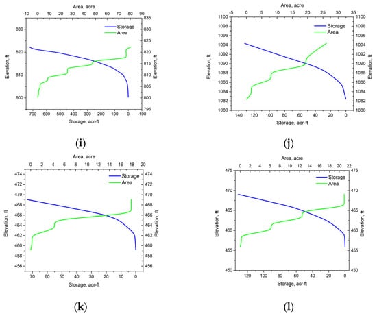
Figure 6.
Multiple graphical representations, showing the area, volume, and curve of the proposed Cascade Reservoirs. (a) Area volume Curve Goth Sumar Reservoir-1. (b) Area volume Curve Goth Sumar Reservoir-2. (c) Area volume Curve Goth Sumar Reservoir-3. (d) Area volume Curve Goth Sumar Reservoir-4. (e) Area volume Curve Goth Sumar Reservoir-5. (f) Area volume Curve Goth Sumar Reservoir-6. (g) Area volume Curve Goth Sumar Reservoir-7. (h) Area volume Curve Goth Sumar Reservoir-8. (i) Area volume Curve Goth Sumar Reservoir-9. (j) Area volume Curve Goth Sumar Reservoir-10. (k) Area volume Curve Goth Sumar Reservoir-A. (l) Area volume Curve Goth Sumar Reservoir-B.
Similarly, another cascade reservoir containing two storage points has been delineated in the watershed of Goth Baro, Union Council, and Tehsil of Thana Boula Khan. The area of the watershed contains 14.2326 km2, with a live cumulative storage capacity of 0.25233 MCM (Figure 4 and Table 2). Both storage points are located at the same elevation of 469 ft, as the bed (depression) elevation of Reservoir A is 459 ft, and that of Reservoir B is 456 ft. Reservoir A covers an area of 18 acres, with a storage capacity of about 70 acre-ft, and Reservoir B covers an area of 21 acres, with a storage capacity of more than 120 acre-ft (Figure 6k,l). We estimate the water availability to be 2.88, 3.84, 5.00, 5.02, and 9.45 MCM at 5, 10, 20, 25, and 75 years for the different return periods, respectively (Figure 5b). However, the storage capacity in both cases may be expanded by raising the walls and strengthening the periphery bunds, and developing the spillway to manage the flow system.
4. Discussion
The research area is spread over an uneven landscape of around 5273.25 km2 in the southwest Khirthar Nation range of Sindh province, Pakistan. The study area is a completely rain-fed area, and under these harsh conditions, the people depend on the precipitation pattern and, consequently, rainwater harvesting for their agriculture and livelihoods. The identified potential reservoirs may be designed for the 5 year return period with the least investment and the maximum return of the financial benefits at the heights of the hill of Khirthar National Range. Furthermore, the long-term results would be strengthened socio-economic conditions for the people and reduced poverty and migration. The cascade reservoirs can manage the flood risk from one reservoir to another by distributing the inflow and outflow pressure and managing discharge [29]. In our review of several other studies, we found some interesting results. Heryani et al. [21,22] conducted a study to develop water management strategies and irrigation systems for highland agriculture purposes. The study revealed changes in crop yield and determined the need to enhance irrigation systems through water-harvesting techniques in the highlands. Similarly, Martel et al. [30] conducted research at three different sites in Canada. The model was tested in the cascade flow network for hydrology, achieving a result comparable to agriculture models by handling an easy operating system without any calibration. The cascade-type reservoirs operated efficiently by coordinating the stakeholders, for a multi-objective agricultural and socio-economic ecosystem [5]. As a result of cascade reservoirs from watershed management, variations in soil properties and methods may affect the quality of food in a developing ecosystem, consequently improving human health and people’s socio-economic conditions [31]. The sediment load is reduced in cascade reservoirs [10]. Water conservancy plans are beneficial for the stakeholders to mitigate the dry and wet spell impacts on the region [3,8,12,18,32]. Managing proper water supply for different chores, power generation, and sustaining the environment by improving the ecosystem are the main outcomes of the reservoirs. In cascade reservoir operation, the subsystems are intricately connected and organized through the concept of a nexus [33].
The role of SRS and GIS in such types of studies has been fundamental. Indeed, these technologies have unlocked a new chapter of research, enabling the retrieval and development of a complete selection of maps along with comprehensive information, which helps with decision-making when designing natural resource studies that require less time and investment and achieve higher accuracy. t also provides appropriate knowledge of simulation and adjustments [34,35,36,37,38]. The availability of exceptional and reliable rainfall information is greatly beneficial for the majority of hydrological investigations and the design, improvement, and management of water asset frameworks.
5. Conclusions
The present study was conducted in the subpart of Khirthar National Park (KNP), Sindh province, Pakistan. Due to its location between the plateau of Baluchistan and the Sindh Plain, diverse topographical conditions can be found in KNP, consisting of large open areas covered by hills, which represent syncline and anticline topography. The current study concluded that temporal satellite images play a prominent role in analysis for spatiotemporal studies using remote sensing and a GIS modeling approaches instead of a general survey or conventional mapping. In the current study, 12 potential storage sites have been identified in the form of two cascade reservoirs at different locations to store a 1.57 MCM volume of water. However, the maximum potential of water varies during the different return periods of 5, 10, 20, 25, 50, and 75 years. Goth Sumer Watershed spreads over 61.046 km2 and has one identified cascade reservoir with ten potential runoff storage capacity points of 1.320 MCM storage capacity. The watershed is estimated to be able to produce 12.35 to 40.53 MCM of water from 5 to 75 years for the different return periods. Meanwhile, the watershed of Goth Baro, spreading over 14.23 km2, has one identified cascade reservoir with two storage points with a total storage capacity of 0.25 MCM. The water potential of this watershed ranges from 2.88 to 9.45 MCM from 5 to 75 years for the different return periods. Both cascade storage reservoirs are proposed for the 5 year return period. The study area has vast potential for surface WRs during the wet (monsoon) seasons, as described through the return period.
The current research addresses one of the water scarcity and food security solutions to mitigate the upcoming worsening situation of climate change by identifying the potential watersheds and natural storage depressions in the hilly range of the study area. This may be strengthening/rehabilitating and upscaling the identified natural depressions using the advanced technologies of hydrological and remote sensing modeling, while planning and managing water through alternate energy pumping systems feeding into the agricultural lands using high-efficiency irrigation systems. Consequently, land leveling, appropriate irrigation methods, and re-estimation of crop water requirements with proper scheduling may increase crop and water productivity.
Such efforts would facilitate the people in hilly arid areas to play a role in sustainable regional food security, thereby improving their socio-economic conditions, reducing the migration rate, and alleviating poverty. Researchers, academia, and stakeholders can all play an important role.
Component-wise planning and management of the reservoirs may play an important role in improving crop production and socio-economic sustainability. Water may be captured in the natural depressions during precipitation through runoff. The quality and quantity of the stored water depend on the physiography of the soil conditions and rainfall variability. The stored water could be used with the managed operational system as an alternative source of energy for domestic and agricultural purposes. The pumped water could be managed with a highly efficient irrigation system for crop purposes as well as maintaining the environmental ecosystem of the region. The stored water could be further percolated to contribute to a groundwater aquifer in order to increase the yield and quality of crops, or may be utilized as an alternative source of water during dry periods.
The current study represents a small part of efforts to contribute to the water sector; the government may have to make minor investments in small reservoirs at the regional level to develop dryland areas to become more sustainable. This would reduce the water scarcity issues and the upcoming burden of the migration of people along with livestock from the hilly regions to the irrigated and industrial areas.
The water scarcity issues must be urgently addressed to mitigate the future impact of the water situation in the country. The task is challenging and extremely sensitive, as well as extensive in scope.
Author Contributions
Conceptualization, A.G.S. and S.A.S.; methodology, H.A.K. and S.P.; validation, D.M. and A.H.M.; formal analysis, A.G.S., H.A.K. and S.A.S.; investigation, S.P. and D.M.; resources, A.H.M.; data curation, A.G.S. and S.A.S.; writing—original draft preparation, A.G.S. and H.A.K.; writing—review and editing, S.A.S. and R.S.A.; visualization, H.A.K. and S.P.; supervision, R.S.A.; project administration, R.S.A. All authors have read and agreed to the published version of the manuscript.
Funding
This research was supported by Researcher Supporting Project number 275 (RSP-2021/310), King Saud University, Riyadh, Saudi Arabia.
Data Availability Statement
Data are available upon request from the first author.
Acknowledgments
The authors acknowledge King Suad University, Saudi Arabia, for support and resources.
Conflicts of Interest
It is therefore declared that the authors do not have any conflict of interest in the publication of the current research article nor any authorship sequence. The article is not considered in any other research Journal or published.
References
- Rashid, M.U.; Abid, I.; Latif, A. Optimization of hydropower and related benefits through Cascade Reservoirs for sustainable economic growth. Renew. Energy 2021, 185, 241–254. [Google Scholar] [CrossRef]
- Solangi, G.S.; Siyal, A.A.; Siyal, Z.-U.; Siyal, P.; Panhwar, S.; Keerio, H.A.; Bhatti, N.B. Social and ecological climate change vulnerability assessment in the Indus delta, Pakistan. Water Pract. Technol. 2022, 17, 1666–1678. [Google Scholar] [CrossRef]
- Soomro, A.G.; Babar, M.M.; Arshad, M.; Memon, A.; Naeem, B.; Ashraf, A. Spatiotemporal variability in spate irrigation systems in Khirthar National Range, Sindh, Pakistan (case study). Acta Geophys. 2019, 68, 219–228. [Google Scholar] [CrossRef]
- Memon, A.; Ansari, K.; Soomro, A.G.; Jamali, M.A.; Naeem, B.; Ashraf, A. Estimation of groundwater potential using GIS modeling in Kohistan region Jamshoro district, Southern Indus basin, Sindh, Pakistan (a case study). Acta Geophys. 2019, 68, 155–165. [Google Scholar] [CrossRef]
- Yu, Y.; Zhao, R.; Zhang, J.; Yang, D.; Zhou, T. Multi-objective game theory optimization for balancing economic, social and ecological benefits in the Three Gorges Reservoir operation. Environ. Res. Lett. 2021, 16, 085007. [Google Scholar] [CrossRef]
- Sivakumar, M.V.K.; Vittal, K.P.R.; Eslamian, S. Indian Experiences in Water Harvesting Systems. In Handbook of Water Harvesting and Conservation: Case Studies and Application Examples; Saeid, E., Faezeh, E., Eds.; John Wiley & Sons, Ltd.: Hoboken, NJ, USA, 2021; pp. 325–339. [Google Scholar]
- Solangi, G.S.; Shah, S.A.; Alharbi, R.S.; Panhwar, S.; Keerio, H.A.; Kim, T.-W.; Memon, J.A.; Bughio, A.D. Investigation of Irrigation Water Requirements for Major Crops Using CROPWAT Model Based on Climate Data. Water 2022, 14, 2578. [Google Scholar] [CrossRef]
- Jehanzaib, M.; Shah, S.A.; Yoo, J.; Kim, T.-W. Investigating the impacts of climate change and human activities on hydrological drought using non-stationary approaches. J. Hydrol. 2020, 588, 125052. [Google Scholar] [CrossRef]
- Shah, S.A.; Jehanzaib, M.; Lee, J.-H.; Kim, T.-W. Exploring the Factors Affecting Streamflow Conditions in the Han River Basin from a Regional Perspective. KSCE J. Civ. Eng. 2021, 25, 4931–4941. [Google Scholar] [CrossRef]
- Li, D.; Lu, X.X.; Yang, X.; Chen, L.; Lin, L. Sediment load responses to climate variation and cascade reservoirs in the Yangtze River: A case study of the Jinsha River. Geomorphology 2018, 322, 41–52. [Google Scholar] [CrossRef]
- He, S.; Guo, S.; Yang, G.; Chen, K.; Liu, D.; Zhou, Y. Optimizing Operation Rules of Cascade Reservoirs for Adapting Climate Change. Water Resour. Manag. 2019, 34, 101–120. [Google Scholar] [CrossRef]
- Shah, S.A.; Jehanzaib, M.; Yoo, J.; Hong, S.; Kim, T.-W. Investigation of the Effects of Climate Variability, Anthropogenic Activities, and Climate Change on Streamflow Using Multi-Model Ensembles. Water 2022, 14, 512. [Google Scholar] [CrossRef]
- Abera, F.F.; Shumete, A. Optimal Operation of Cascade Reservoir Systems under Climate Change: Case Study of Tekeze Hydropower Reservoir in the Tributary of the Blue Nile River. Abyssinia J. Eng. Comput. 2021, 1, 31–46. [Google Scholar] [CrossRef]
- Foucher, A.; Evrard, O.; Cerdan, O.; Chabert, C.; Lefèvre, I.; Vandromme, R.; Salvador-Blanes, S. Deciphering human and climatic controls on soil erosion in intensively cultivated landscapes after 1950 (Loire Valley, France). Anthropocene 2021, 34, 100287. [Google Scholar] [CrossRef]
- Panhwar, M.Y.; Panhwar, S.; Keerio, H.A.; Khokhar, N.H.; Shah, S.A.; Pathan, N. Water quality analysis of old and new Phuleli Canal for irrigation purpose in the vicinity of Hyderabad, Pakistan. Water Pract. Technol. 2022, 17, 529–536. [Google Scholar] [CrossRef]
- Mirjat, M.S.; Soomro, A.G.; Mirjat, K.H.; Mirjat, M.U.; Chandio, A.S. Potential of Hill-Torrent Spate Irrigation in the Kohistan Areas of Sindh “A Case Study”. Pak. J. Agric. Agric. Eng. Vet. Sci. 2011, 27, 100–114. [Google Scholar]
- Rijsberman, F.R. Water scarcity: Fact or fiction? Agric. Water Manag. 2006, 80, 5–22. [Google Scholar] [CrossRef]
- Memon, A.; Ansari, K.; Ashraf, A.; Soomro, A.G. Identifying the hill torrents and Groundwater Resources for a remote area of District Jamshoro using Remote Sensing and Geographical Information System. Sindh Univ. Res. J. (SURJ) Sci. Ser. 2019, 54, 303–308. [Google Scholar] [CrossRef]
- Cai, X.M.; Rosegrant, M.W. World water productivity: Current situation and future options. Compr. Assess. Water Manag. Agriculture. CABI Int. 2003, 53, 163–178. [Google Scholar] [CrossRef]
- Sullivan, C.A.; Meigh, J.; Giacomello, A.M. The Water Poverty Index: Development and application at the community scale. Nat. Resour. Forum 2003, 27, 189–199. [Google Scholar] [CrossRef]
- World Bank. Reengaging in Agricultural Water Management: Challenges and Options; The World Bank: Washington, DC, USA, 2006; p. 218. [Google Scholar]
- Heryani, N.; Kartiwa, B.; Hamdani, A.; Muhardiono, I.; Rahayu, B. Rainwater harvesting technology to in-crease cropping index under perennial crops. In Proceedings of the IOP Conference Series: Earth and Environmental Science, Bogor, Indonesia, 16–18 September 2020. [Google Scholar]
- Han, F.; Zheng, Y.; Tian, Y.; Li, X.; Zheng, C. Accounting for field-scale heterogeneity in the ecohydrological modeling of large arid river basins: Strategies and relevance. J. Hydrol. 2021, 595, 126045. [Google Scholar] [CrossRef]
- Liebe, J.; Andreini, M.; van de Giesen, N.; Steenhuis, T. The small reservoirs project: Research to improve water availability and economic development in rural semi-arid areas. In The Hydro Politics of Africa: A Contemporary Challenge; Kittisou, M., Ndulo, M., Nagel, M., Grieco, M., Eds.; Cambridge Scholars: Newcastle, UK, 2007; pp. 325–332. [Google Scholar]
- United Nations Development Programme, 2016 Annual Report. Available online: http://web.undp.org/evaluation/documents/annual-report/2017/UNDP_ARE_2016.pdf (accessed on 13 September 2022).
- Soomro, A.G.; Babar, M.M.; Ashraf, A.; Memon, A. The Relationship between Precipitation and Elevation of the Watershed in the Khirthar National Range. Mehran Univ. Res. J. Eng. Technol. 2019, 38, 1067–1076. [Google Scholar] [CrossRef]
- Sindh Government, Potential Areas for Small Dams/Weirs. Available online: https://irrigation.sindh.gov.pk/small-dam (accessed on 13 September 2022).
- Human Development Report. (HDI). 2010. Available online: https://hdr.undp.org/content/human-development-report-2010 (accessed on 13 September 2022).
- Liu, J.; Yuan, X.; Zeng, J.; Jiao, Y.; Li, Y.; Zhong, L.; Yao, L. Ensemble streamflow forecasting over a cascade reservoir catchment with integrated hydrometeorological modeling and machine learning. Hydrol. Earth Syst. Sci. 2022, 26, 265–278. [Google Scholar] [CrossRef]
- Martel, M.; Glenn, A.; Wilson, H.; Danielescu, S.; Kröbel, R.; Smith, W.; McConkey, B.; Guest, G.; Janzen, H. A parsimonious water budget model for Canadian agricultural conditions. J. Hydrol. Reg. Stud. 2021, 36, 100846. [Google Scholar] [CrossRef]
- Memon, A.; Ansari, K.; Ashraf, A.; Babar, M.M.; Soomro, A.G. Projected Rainfall Variability Based on PRECIS Regional Model. Mehran Univ. Res. J. Eng. Technol. 2019, 38, 513–524. [Google Scholar] [CrossRef]
- Ren, K.; Huang, Q.; Huang, S.; Ming, B.; Leng, G. Identifying complex networks and operating scenarios for cascade water reservoirs for mitigating drought and flood impacts. J. Hydrol. 2021, 594, 125946. [Google Scholar] [CrossRef]
- Qiu, H.; Chen, L.; Zhou, J.; He, Z.; Zhang, H. Risk analysis of water supply-hydropower generation-environment nexus in the cascade reservoir operation. J. Clean. Prod. 2021, 283, 124239. [Google Scholar] [CrossRef]
- Yuan, F.; Sawaya, K.E.; Loeffelholz, B.; Bauer, M.E. Land cover classification and change analysis of the Twin Cities (Minnesota) Metropolitan Area by multi-temporal Landsat remote sensing. Rem. Sen. Environ. 2005, 98, 317–328. [Google Scholar] [CrossRef]
- Selçuk, R.E.I.S.; Nisanci, R.; Uzun, B.; Yalcin, A.; Inan, H.; Yomralioglu, T. Monitoring land-use changes by GIS and remote sensing techniques: A case study of Trabzon. In Proceedings of the 2nd FIG Regional Conference, Marrakech, Morocco, 2–5 December 2003; pp. 1–11. [Google Scholar]
- Brondizio, E.S.; Moran, E.F.; Mausel, P.; Wu, Y. Land use change in the Amazon estuary: Patterns of caboclo settlement and landscape management. Hum. Ecol. 1994, 22, 249–278. [Google Scholar] [CrossRef]
- Kachhwala, T.S. Temporal monitoring of forest land for change detection and forest cover mapping through satellite remote sensing. In Proceedings of the 6th Asian Conference on Remote Sensing, Hyderabad, India, 21–26 November 1985; pp. 77–83. [Google Scholar]
- Soomro, A.G.; Babar, M.M.; Memon, A.H.; Zaidi, A.Z.; Ashraf, A.; Lund, J. Sensitivity of Direct Runoff to Curve Number Using the SCS-CN Method. Civ. Eng. J. 2019, 5, 2738–2746. [Google Scholar] [CrossRef]


Publisher’s Note: MDPI stays neutral with regard to jurisdictional claims in published maps and institutional affiliations. |
© 2022 by the authors. Licensee MDPI, Basel, Switzerland. This article is an open access article distributed under the terms and conditions of the Creative Commons Attribution (CC BY) license (https://creativecommons.org/licenses/by/4.0/).