Abstract
The study of rural habitat systems from the perspective of resilience is of great significance in revealing the inner laws of the evolution of the rural human settlements system and promoting sustainable rural development. This study aims to explain the theoretical connotation of the rural human settlements system resilience (RHSSR), construct an evaluation system and zoning rules for rural habitat system resilience, and explore the spatial distribution pattern of rural habitat system resilience in China and the factors influencing the differences in the level of rural resilience using 30 Chinese provinces as examples to provide effective governance solutions for sustainable rural development. The results show that: (1) The RHSSR refers to the sustainability of the RHSS; i.e., the ability of a system to absorb and adapt to internal and external disturbances and shocks by adjusting the structure and scale of its internal elements, discarding the original inapplicable state to the greatest extent possible and creating a new recovery path to another new equilibrium state. (2) The overall downward trend of RHSSR in 30 Chinese provinces between 2000 and 2020 is consistent with the fact that a large number of villages have died out in China in recent years. (3) The RHSSR is higher in eastern China than in central and western China; although the regional gap is gradually narrowing. (4) An analysis of the evolutionary trend of the RHSSR shows that the northeastern and eastern regions of China belong to the major evolution area of the RHSSR; most areas in central and western China belong to the degraded vulnerable area of the RHSSR, while the potential recession area of the RHSSR is more scattered, mainly in Beijing, Tianjin, and Inner Mongolia in northern China, Chongqing, Hubei, and Qinghai in central China, and Guangdong and Fujian in the southern China region of Guangdong and Fujian. (5) The results of the analysis of geographical detectors show that the effect of the basic-driven factors in the RHSSR decreases significantly with time, while the effect of the core-driven and externally-driven factors increases, and the effect of the two factors is greater than that of the single factor. Among them, industrial structure (IS) has an important influence on the spatial differentiation of the resilience level of rural human settlements system. (6) Optimization strategies are proposed in terms of spatial planning; industrial integration and public participation for the development of different sub-regions.
1. Introduction
China’s rural spaces, once relatively protected from external factors such as globalization, industrialization, and urbanization, are increasingly under pressure from the rapid industrialization experienced across the country [1]. When the impact of changes in the external development environment exceeds the self-regulation threshold of the village, the direct consequence is the decline of the village [2]. The problem of rural decline has become a common challenge for most countries around the world [1]. As one of the most important spatial forms of land use in China’s land areas [3], the decline of the countryside is undoubtedly more pronounced in the context of China’s rapid urbanization [1]. In China, the decline of the countryside has led to a series of problems such as hollowing out of the countryside [4], aging [5], and ecological degradation [6]. Therefore, in order to enable the countryside to better cope with the ever-present external disturbances and crises, it is necessary to study the composition and patterns of the rural human settlements system (RHSS) and further enhance the rural human settlements system resilience (RHSSR).
The academic research on resilience has gone through three stages: physical resilience [7], ecological resilience [8], and evolutionary resilience [9,10], and the connotation has evolved from the initial emphasis on the efficiency and speed of recovery to the ability to adapt and transform [11]. In the evolutionary resilience phase of research, Walker et al. (2004) suggested that resilience should not only be seen as a recovery of a system from its initial state, but as the ability of a complex social-ecological system to change, adapt, and transform in response to pressures and constraints [9]. Falk et al. (2010) also argued that the current phase of resilience thinking focuses on three different aspects of social-ecological systems, namely resilience as persistence, adaptability, and transformability [10]. This is the concept of resilience in evolutionary resilience theory, in which a resource system constantly adapts its structure to external disturbances and stimuli, and uses the self-regulatory and external protection capacities granted by the socio-economic system to create new development paths and thus increase its sustainability [12]. The connotation of resilience has been different from the single recovery and resilience, and is essentially a coupling of the two [9]. The research object of resilience gradually shifts from abstract ecological resilience [13] and economic resilience [14,15] to concrete city resilience [16,17], community resilience [18], landscape resilience [19,20], and disaster management resilience [21,22]. Along with the deepening of resilience theory research, the cup-and-ball model [23], the sphere-basin model [9], the adaptive cycle model [24], and the multi-scale nested adaptive cycle model [24] have been proposed, which have important guiding significance for resilience research. In addition, along with the rise and development of metrology, the research methods of toughness have also shifted from qualitative analysis to quantitative assessment [25,26].
The rural human settlements system plays an important role in providing material and non-material support for villagers’ production and livelihood [27]. Compared with regional and metropolitan areas, rural areas are more vulnerable to external shocks because they lack the necessary financial and human resources to implement planning and respond to emergencies. In recent years, the promotion of sustainable development of rural habitat has become a global consensus, such as rural settlement and rural settlement geography theoretical system [28], rural settlement location, morphology and land use [29,30], rural planning and construction [31,32,33], rural habitat evolution and mechanism [34,35], rural migration and reverse urbanization [36,37], rural habitat landscape maintenance [38,39], rural habitat vulnerability [40,41], etc. These have become hot topics of international attention and research. In addition, relevant policies and conference proposals have shown that promoting sustainable development of rural habitats has become an important research topic of theoretical and practical significance in China and the world. The International Symposium on Global Rural Development and Land Capacity Building, first proposed the Global Rural Plan (GRP) in 2017, focuses on global rural development and land degradation [42]. In addition, the Chinese government issued the Three-Year Action Plan for Rural Habitat Improvement in 2018 and the Circular on Strengthening Village Planning for Rural Revitalization in 2019. These policies aim to improve the spatial governance capacity of rural human settlements.
As an important carrier of the relationship between rural people and land, the rural habitat system also has the basic property of resilience. Resilience is a necessary condition for the sustainable development of the system and, to a certain extent, it reflects the sustainable development ability of the rural human settlement system. At present, the rural habitat system is facing the pressure and crisis of serious labor exodus [43,44], sloppy land use [45,46], industrial decay [47], and environmental pollution [48,49,50]. It can be said that the sustainable development of the system is facing serious challenges. Therefore, scientific recognition and interpretation of the RHSSR can help cultivate the resilience of rural habitat systems to cope with internal and external disturbances, and thus resolve the impacts and crises from internal and external environments, which is undoubtedly of outstanding value to enhance the endogenous momentum of rural development and realize rural revitalization and sustainable rural development.
The main objectives of this study are to (i) try to define the conceptual connotations of the RHSSR, and to construct an index system and zoning rules based on the characteristics of the RHSSR itself from the perspective of resilience theory; (ii) take 30 provinces of China as evaluation units, analyze the temporal and spatial evolution characteristics of the RHSSR in China, divide the types of the RHSSR according to zoning rules, and clarify its influence mechanisms; (iii) provide new ideas and a scientific basis for promoting sustainable rural development and rational deployment of regional resources by exploring the sustainable development management ideas of different zones.
2. Theoretical Analysis of RHSSR
2.1. Definition of the Connotation
The system may be constantly disturbed by various factors such as nature, society, and policy in the process of sustainable development. The system is often in a non-equilibrium, non-linear dynamic change, so its resilience needs to be considered according to the properties that control its dynamics [9]. Walker et al. (2004) argued that under social-ecological systems (SESs), resilience should be understood not only as a recovery of the system from its initial state, but also as a continuous capacity of a complex social-ecological system to change, adapt and change in response to pressures and constraints that are constantly stimulated [9]. Therefore, based on the theory of evolutionary resilience, RHSSR means the sustainability of the RHSS, i.e., the ability of the system to absorb and adapt to internal and external disturbances and shocks by adjusting the structure and scale of its internal elements, discarding the original inapplicable state to the greatest extent possible, creating a new recovery path and thus reaching a new equilibrium.
2.2. Adaptive Cycle of RHSS
The essence of the evolutionary resilience perspective stems from a new system cognitive concept, the Adaptive Cycle theory proposed by Holling and Gunderson (2001) [24]. In contrast with the description of existing system structure studies, they believe that the development of a system consists of four phases, namely the exploitation phase, conservation phase, release phase, and reorganization phase. The process of the RHSS creating a new recovery path and shifting to a new equilibrium state can be considered as the adaptive cyclic process of the RHSS. The specific processes are as follows: (i) Exploitation Phase. Under the influence of globalization, urbanization, industrialization, suburbanization, and other trends, the rural habitat system is frequently disturbed by the exchange of external environmental elements (including capital, technology, culture, etc.,) and internal elements (including natural subsystems, human subsystems, settlement subsystems, support subsystems, and social subsystems) and, due to the diversity of choices and the relative flexibility of the organization of elements, the system shows a high magnitude of resilience. (ii) Conservation Phase. With the fixation of elemental organization, the system gradually takes shape due to the further strengthening of inter-elemental connectivity, while its growth potential turns to be reduced. At this time, the system has a low toughness. (iii) Release stage. Under the stimulation of the external environment, the system needs to break some of the inherent connections to achieve new development. The potential grows until the chaotic collapse occurs. At this point, the system has a low level of resilience but has a tendency to grow. (iv) Reorganization stage. Some of the resilient rural habitat systems are reorganized through innovation to support the further development of the system and enter the utilization phase to achieve the adaptive cycle. However, some of the less resilient rural areas, in the reorganization phase, lack the necessary resilience of the system, thus leaving the cycle and resulting in the decay of the environmental system.
2.3. Composition of RHSSR
The Greek urban planner C.A. Doxiadis theorized about human settlements [51]. Chinese urban planner Wu L.Y. draws on this theory and puts forward a human settlements system suitable for China’s development context [52]. He divided the system into five subsystems: the natural subsystem, the human subsystem, the living subsystem, the support subsystem, and the social subsystem. The RHSS, as a typical human settlements system, is composed of these five subsystems. At the same time, the RHSS also has the characteristics of openness, non-linearity, non-stability, and continuous rise and fall. Changes in any one element of the system will cause corresponding changes in other elements, forming a chain reaction and leading to changes in the system state. The RHSSR mainly reflects the adaptability of the RHSS transformation. Therefore, from the above-mentioned driving forces and results leading to the RHSS transformation, it is appropriate to measure the RHSSR with the help of five subsystems: natural, human, residential, support, and social.
The natural subsystem is an important foundation for the RHSS to emerge and perform its functions stably, and its resilience is mainly reflected in forest cover, biological richness, soil erosion level, etc. The human subsystem is the intrinsic driving force to promote the sustainable development of the rural habitat environment system, mainly embodied in the rural labor force level, family size, cultural and educational level, etc. The housing subsystem provides the living material environment that human systems and social systems need to use, and is an important means for the RHSS to resist the influence of external factors and guarantee quality of life. Its resilience is mainly reflected in the residential conditions, the level of social and public facilities, etc. The support subsystem plays the role of providing support and service guarantee for human activities and social interactions, and it links rural settlements as a whole through infrastructure networks (e.g., electricity, water supply, transportation, communication, etc.). The social subsystem provides services for higher-level needs such as economic development, residents’ welfare, and social equity. Its resilience is reflected in agricultural commercialization, villagers’ income level, etc. (Figure 1).
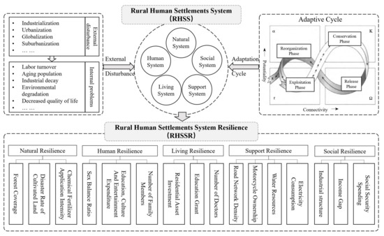
Figure 1.
Rural human settlements system resilience (RHSSR) composition and its logical framework.
3. Research Methods and Data Sources
3.1. Research Methods
3.1.1. Comprehensive Measures of RHSSR
- (1)
- Assigning weights to variables
A combination of subjective and objective methods are used to assign weights to variables, i.e., the weights of indicators are calculated separately using the analytic hierarchy process (AHP) and the entropy weight method (EWM), and then they are scored comprehensively. They can avoid the arbitrariness and randomness of a single subjective weighting method to a certain extent, and also make up for the disadvantages of the entropy method regarding the loss of data information [53].
- (a)
- Analytic hierarchy process (AHP)
Firstly, each index is decomposed into sub-attributes, and each index at the same level is analyzed and compared two by two to construct a judgment matrix. Secondly, the consistency test is conducted to determine the weights of each indicator. Finally, the weighting method is applied to calculate the weight value of all the indicators in this level to the previous level, and then synthesize them layer by layer to find the comprehensive weight as [54].
- (b)
- Entropy weight method (EWM)
Entropy is a measure of uncertainty. The greater the amount of information, the smaller the uncertainty and the smaller the entropy; conversely, the greater the entropy.
First, the data corresponding to each indicator are dimensionless.
(Positive indicators)
(Negative indicators)
are the total number of evaluation indicators and evaluation objects respectively; , are the maximum and minimum values of different indicators j in all evaluation objects. Normalization of indicators:
Calculate the entropy value of each indicator:
in (2).
Calculate the redundancy of the entropy value of each indicator:
Calculate the weights of each indicator:
- (c)
- Comprehensive weights
Using the weights obtained from the analysis of the previous two steps and setting the preference coefficients to μ = 0.5, respectively, the weights of each index are calculated as follows:
- (2)
- Comprehensive measure: the SPA theory
Set pair analysis (SPA) is a mathematical theory first proposed by Zhao in 1989 [55]. It is used to deal with the interaction between the certainty and uncertainty of a system. The SPA theory focuses on studying the interaction between certainty and uncertainty of a given system under three aspects—common characteristics, opposite characteristics, and neither common nor opposite characteristics—to conduct a quantitative evaluation of the research object [56].
Let set A and set B be a set pair H. In the context of the RHSSR, i.e., X, construct the relationship between the three faces of identity, difference, and opposition. Construct the formula:
where , , and denote the degree of homogeneity, difference, and opposition of the set pair H in the context, respectively, and a + b + c = 1. N is the coefficient of difference and opposition, the value of i is specified as [–1, 1], and the value of j is constant at 1. According to the idea of set-pair analysis, the indicators of each dimension of the RHSSR are compared in the same space. q = {F, D, E, W}, F is the solution set, D is the indicator set, E is the object set, and W is the weight set. The optimal evaluation set of each program is specified as O, and the worst evaluation set of each evaluation program is V. Then and are the optimal and worst values of the indexes, respectively. The degree of association of the set pair {, O} on [O, V]:
where apk and are the degree of identity and opposition to the evaluation index with the set , respectively, and is the weight of the th index.
When is positive for the evaluation result:
When is negative for the evaluation result:
The relative closeness of scheme to the optimal set of schemes can be defined as:
reflects the degree of association between the evaluated solution and the optimal solution set . A larger value indicates that the evaluated object is closer to the optimal solution. Therefore, the RHSSR level of each province in China can be evaluated based on the magnitude of the value.
3.1.2. Driving Mechanism Measures of RHSSR: Geographical Detectors
A geographical detector is an important tool to explore the influence mechanism of geo-spatial partition factors [57]. It can identify driving factors through factors and interactions without too many assumptions [58].
- (1)
- Factor detector
A factor detector can reveal the relative importance of variables and is a core part of the geographical detector [59]. If the changes in environmental factors and geographical things are consistent, it means that the factors have decisive significance for the occurrence and development of geographical things.
In the formula, is the influence detection index, is the number of samples in the entire region, is the number of sub-regional samples, is the number of sub-regions, is the variance of the resilience index of rural human settlements, and is the variance of the resilience of the sub-regional human settlements system. The larger the value of , the greater the impact of driving factors on the spatial distribution of the resilience of the rural human settlements system.
- (2)
- Interaction detector
Interaction detectors can quantitatively characterize whether the influence of two factors on the spatial pattern is stronger or weaker than that of a single factor. The interaction includes five relationships: non-linear weaken, single linear weaken, bi-variable enhancement, independent, and nonlinear enhancement [60,61,62].
3.1.3. Evaluation Index System for RHSSR
According to the connotation of the RHSSR and following the principles of scientific, typicality, and data availability, an evaluation index system was constructed based on the five major subsystems of the RHSS to comprehensively characterize the RHSSR. A good natural environment can provide basic material support and ecological protection for villagers’ production and life, thus helping villages to resist natural and unnatural external disturbances. Starting from the regulating ability of a natural system, the forest coverage (X1), disaster rate of cultivated land (X2), and chemical fertilizer application intensity (X3) are selected to characterize the resilience of a natural subsystem of the human settlements system. Physiological needs and emotional needs are the key elements to understanding the human system, so three indicators are selected to characterize the level of human subsystem resilience, namely, the sex balance ratio (X4), the number of family members (X6), and the percentage of villagers’ per capita expenditure on education, culture, and recreation (X5). The housing system is an important physical environment that supports human production and life. It consists of residences and social and public facilities such as hospitals and schools. Therefore, the rural residential asset investment ratio (X7), rural students per capita government expenditure on education(X8), and the number of rural doctors per 1000 people in rural areas (X9) are selected to characterize the resilience level of the rural residential subsystem. The support system is the security system that provides support and services for human social interactions. Road network density (X10), use of durable goods in rural areas (X11), per capita water resources (X12), and rural electricity consumption per capita (X13) are selected to measure the level of infrastructure network construction and characterize the resilience of rural support subsystems. The social system serves higher-level needs such as economic development and residents’ welfare. Thus, agricultural income proportion in total income (X14), per capita income ratio of urban and rural residents (X15), and per capita financial subsidy (X16) are selected as characterizations (Table 1).

Table 1.
Rural Human Settlements System Resilience (RHSSR) Evaluation Index System.
3.2. Data Sources
Secondary statistics publicly available on the Chinese government website were used in this study. The data were divided into economic statistics and ecological statistics. These data were obtained directly or indirectly from the China Statistical Yearbook (2001–2021), the China Rural Statistical Yearbook (2001–2021), and the China Population and Employment Statistical Yearbook (2001–2021). In addition, data are also obtained from the statistical yearbooks of individual provinces.
3.3. Research Area
A rural area is one of the most important spatial patterns of land use in China (Figure 2), and the RHSS is an important carrier of rural production and life, providing quality physical environment, protection for villagers’ life, and development. The RHSS also carries traditional Chinese culture and thought. In the more than 40 years since China’s reform and opening up, China has made remarkable achievements in economic growth and social development. China’s GDP per capita has changed from RMB 382 in 1978 to RMB 80,976 in 2021, and the per capita disposable income of rural residents has increased from RMB 133.6 to RMB 18,931 in 2021. At the same time, along with the rapid urbanization in China, the RHSS has been impacted by many external material and immaterial elements, leading to endogenous problems such as ecological degradation and social network disintegration, as well as exogenous problems such as urban waste transfer. These problems have caused the imbalance of the RHSS and seriously undermined the sustainable development of China’s countryside. In addition, the Chinese government is vigorously promoting the rural revitalization strategy. However, the problem of mismatch between the government’s resource input to the countryside and the actual development needs of the countryside frequently arises. For example, some villages have a large population exodus and have lost endogenous development power, but still built vacant houses and beautify the environment and landscape. Therefore, a reasonable assessment and prediction of the resilience level of the rural habitat environment, the enhancement of resilience of rural villages in the face of external disturbances, and the improvement of resource allocation efficiency can help Chinese rural villages achieve sustainable development in the most efficient way.
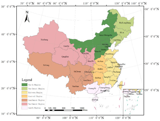
Figure 2.
Administrative Zoning Map of China.
4. Results
4.1. Temporal and Spatial Patterns of RHSSR
4.1.1. General Evolutionary Characteristics
The natural breakpoint method was used to grade the RHSSR of 30 Chinese provinces in 2000, 2005, 2010, 2015, and 2020, respectively (Figure 3). The results show that the overall RHSSR in China is on a declining trend. The RHSSR fell from 0.5155 in 2000 to 0.3942 in 2020, which is consistent with the fact that many villages in China are currently decaying. In terms of spatial distribution, rural resilience is generally higher in eastern China than in the central and western regions. There are two main reasons for this phenomenon: on the one hand, the natural advantage of building port terminals in the eastern coastal regions of China has contributed to their economic development level ahead of the central and western regions. The economic disparity has directly driven many people from the rural areas of central and western China to migrate to cities in eastern China to engage in intra-urban labor-intensive industries. Along with the large number of people moving out, the hollowing-out problem, aging problem, and left-behind children problem in the central and western villages have been highlighted, and the RHSSR has significantly decreased. On the other hand, due to differences in climate, land, and sea location, the natural environmental carrying capacity of rural areas in eastern China is stronger than that of central and western regions. In addition, the value of the RHSSR in northeast China may be high since northeast China is the “big granary” of China with fertile land and a sparse population. Although there are spatial differences in the RHSSR, the differences between regions are gradually decreasing. The standard deviation of the RHSSR decreases from 0.1061 in 2000 to 0.0708 in 2020. This is due to the promotion of China’s “rural revitalization” policy and the implementation of the “War on Poverty Alleviation”, which has brought a large number of government funds, talent, technology, and social capital into central and western China. Regional differences are gradually narrowing.
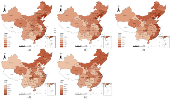
Figure 3.
Spatio-temporal patterns of rural human settlements system resilience (RHSSR) in some areas of mainland China. (a) 2000, (b) 2005, (c) 2010, (d) 2015, and (e) 2020.
4.1.2. Subsystem Evolutionary Characteristics of RHSSR
Natural system resilience. In the time dimension, the resilience of the natural system tends to be stable without large fluctuations, declining slightly from 2005 to 2010, and then gradually increasing from 2010 to 2020. This is closely related to the fact that China has attached great importance to the construction of ecological civilization and the promotion of poverty eradication in recent years. In June 2009, the “Central Forestry Work Conference” of China was held, which emphasized the reform of the collective forestry system as one of the major changes in the rural management system and, in March 2018, the State Council’s “Motion on the State Council’s Institutional Reform Program” proposed the establishment of the State Forestry and Grassland Administration, which will be managed by the Ministry of Natural Resources. At the same time, since 2018, more than 2/3 of China’s afforestation tasks have been arranged in poor areas, and priority has been given to arranging poor people with established cards to participate in afforestation and receive labor income. China has become one of the countries with the fastest growth of forest resources, the largest scale of forestry employment, and the largest accumulation of new forestry carbon sinks in the world through deepening reforms and improving ecological governance capacity in the past decade, and the overall resilience of the natural subsystem of China’s rural habitat shows a steady improvement. Observed in the spatial dimension, the resilience of natural systems in southeastern China is stronger. Due to the influence of climate, soil, water, and other environmental factors, the forest cover in the southern and eastern regions of China has been higher. Among them, the southeastern region is the highest, especially in Fujian, Zhejiang, and Guangdong, where forest cover has been maintained at a high level.
Human system resilience. In the time dimension, from 2000 to 2020, it increased from 0.5068 to 0.5529, showing an increasing trend year by year. Among them, X5 shows an upward trend, X4 shows a decreasing trend and then an increasing trend, and X6 shows a shrinking trend. In the spatial dimension, it shows the spatial characteristics, finding that the central and western regions are higher than the eastern regions. The high-value areas are in Inner Mongolia, Gansu, Hunan, and Guizhou. The occurrence of high values is mainly influenced by family size and gender ratio, and due to the relatively lagging level of socio-economic development leading to traditional ideology, the size of rural families in central and western China is generally high. At the same time, their sex ratios have gradually tended to be balanced in recent years. Gender balance is conducive to the smooth development of families and society. In contrast, rural residents’ education, culture, and entertainment expenditures in the eastern regions, such as Beijing, Shanghai, Guangdong, Tianjin, and other economically developed regions, generally show a gradual decline every five years. The reason is not a decrease in the number of expenditures, but a decrease in the proportion of this expenditure due to faster growth of villagers’ total income. In addition, together with the low household size, the resilience of rural human systems in the eastern region is low.
Living system resilience. In the time dimension, the system resilience decreases from 0.4530 in 2000 to 0.2260 in 2020. The reason may be that along with the out-migration of a large number of the rural population, the demand for rural housing construction tends to saturate, causing a gradual decline in the capital investment in rural residential construction. Additionally, the houses that have been built have not been maintained due to factors such as population exodus and lack of funds. The above reasons have led to the decline of system resilience. In the spatial dimension, the system shows the spatial characteristics of high in the north and low in the south. Local governments in northern China, such as Inner Mongolia, Sichuan, Qinghai, and Guizhou, focus on the problem of improving the living environment of rural residents by building collective resettlement houses for herders and mountain people so that local villagers have a fixed place to live. At the same time, local governments have built public facilities, such as hospitals and schools around the settlements, which have enhanced the level of living systems in these areas.
Support system resilience. In the time dimension, the results also show a decreasing trend, from 0.6824 in 2000 to 0.4761 in 2020. Along with a large rural population exodus, the local government’s investment in some infrastructure construction gradually declines. In the spatial dimension, the support resilience shows the spatial characteristics of high in the east and south and low in the west and north. The economic and social development level is faster in the eastern coastal areas, and the investment in rural infrastructure construction is higher. In contrast, the western region is less. However, along with the promotion of China’s “rural revitalization” policy and “western development” strategy, the central and western regions have also increased their rural construction efforts, actively increased rural infrastructure funding channels, and improved rural infrastructure construction and management levels. The problem of geographical differences has been alleviated.
Social system resilience. In the time dimension, it shows a decreasing trend. Between 2000 and 2020 its resilience level decreases from 0.5155 to 0.3942. Among the indexes, the X14 indicator decreases significantly. In the spatial dimension, the social subsystem resilience level shows the spatial distribution characteristics are high in the northwest and low in the southeast. In recent years, production factors in China have gradually moved from urban to rural areas and from the east to the west. The agricultural industry in the countryside has changed from traditional agriculture to modern agriculture with comparative advantages. While optimizing the agricultural structure, X14 is lowered and the resilience level of northwest China is raised (Figure 4).
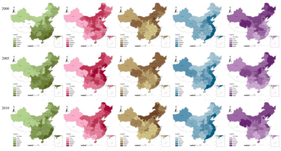
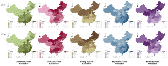
Figure 4.
Spatio-temporal pattern of contribution rates of rural human settlements system resilience (RHSSR) in some regions of mainland China.
4.2. Zoning Characteristics of RHSSR
4.2.1. RHSSR Zoning Rules
The RHSSR in 2020 was classified into three levels: high, medium, and low, by using the natural breakpoint method (Figure 5a). Meanwhile, the growth rate of the RHSSR between 2015 and 2020 was calculated to represent its improvement rate. then, the natural breakpoint method was used to divide it into a high rate of decline, low rate of decline, and positive growth area (Figure 5b). Finally, the two classification results were regionally superimposed (Figure 5c). The partition rule matrix is constructed according to the layer superposition (Table 2).
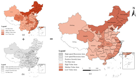
Figure 5.
Schematic representation of the layer stacking process for rural human settlements system resilience (RHSSR) changes. (a) RHSSR in 2020; (b) Growth rate of RHSSR between 2015 and 2020; (c) Result of layer stacking.
Table 2.
The matrix expressing the partitioning rules of rural human settlements system resilience (RHSSR).
Based on the matrix partitioning rules, the partitioning characteristics of the three RHSSRs are as follows:
- Major Evolution Area: High and medium resilience value, and its changing trend is positive growth.
- Potential Recession Area: The resilience value is high and medium, and the trend is rising.
- Degraded Vulnerable Area: The resilience value is medium and low, and it shows a downtrend.
4.2.2. Zoning Characteristics
The RHSSR was partitioned for some regions in mainland China (Figure 6). The RHSSR in parts of northeastern and eastern China belongs to the major evolution area. The RHSSR values in this region are relatively high and show a positive growth trend. Among them, Heilongjiang and Jilin, located in the northeast, have a lower rate of structural imbalance between agricultural and non-agricultural industries, supported by two advantageous conditions of fertile land and advanced agricultural cultivation technology. The social, support, and natural subsystem resilience of the RHSSR increased. The specific situations of Zhejiang and Jiangsu, which are also major development regions, are different compared to that of northeast China. In recent years, local governments in Zhejiang and Jiangsu have been ahead of most provinces in China in terms of rural development. Multi-party cooperation among government, market, and society has effectively accelerated the flow of production factors between urban and rural areas in these regions, enabling the development of multiple integrated industries. Typical examples include the Qingshan Village in Hangzhou, Zhejiang Province, which has actively promoted the integration of tourism and agriculture, and the arts industry and agriculture. The potential recession area is scattered, mainly concentrated in Beijing, Tianjin, Liaoning, and Inner Mongolia in northern China; Chongqing, Hubei, and Qinghai in central China; and Guangdong and Fujian in southern China. It is noteworthy that the villages where metropolitan areas such as Beijing, Shanghai, and Guangdong are located mostly show a potential decline. This indicates the strong population siphoning effect of large cities on the surrounding villages. The large population outflow leads to a decline in the resilience of the social and living subsystems, causing the RHSSR to show a declining trend. Finally, the degraded vulnerable area is mainly concentrated in the central and western regions of China, including Hunan, Shaanxi, Guizhou, and Sichuan. The RHSSR values of these regions are relatively low themselves, i.e., they are more vulnerable. Moreover, they have a negative growth rate and a more obvious decline trend, and the RHSS is extremely vulnerable to external disturbances.
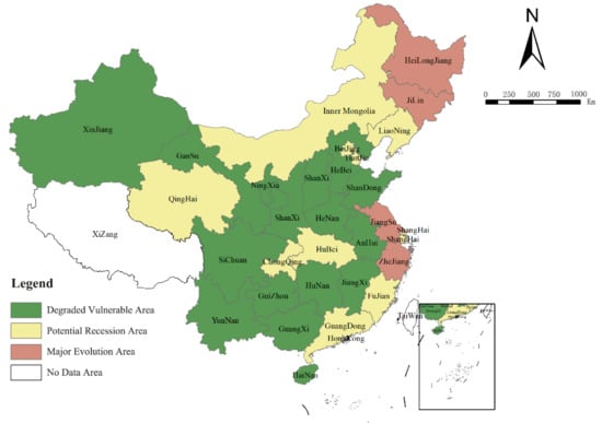
Figure 6.
Rural human settlements system resilience (RHSSR) partition in some areas of mainland China.
4.3. Analysis of Factors Influencing the Spatial Pattern
The resilience level of the Chinese rural human settlements system is affected by a combination of factors. Referring to the relevant research of Yang B. and other scholars [67], we constructed an index system of factors from three dimensions: basic-driven, core-driven, and external-driven (Table 3). Among them, the basic-driven mainly starts from the natural environment of the village itself, which is the basis for the normal operation and stable development of the rural human settlements system [27], the core-driven is the internal driving force for the development of the rural human settlements system and the support for maintaining its sustainable development, and the external-driven focuses more on the external environment to help improve rural habitat, especially education, healthcare and other elements, which enhance the well-being of residents and increase the stability of the system. The software GeoDetector is used to quantitatively measure the RHSSR driven factors of five-time sections in 2000, 2005, 2010, 2015, and 2020.
Table 3.
Driven factors of rural human settlements system resilience (RHSSR).
4.3.1. Factor Detection
The natural breakpoint method was applied to discrete the data of the independent variables and divided into six levels. The values of each influence factor were calculated to characterize the influence of different factors on the RHSSR (Table 4).
Table 4.
of factors in 2000, 2005, 2010, 2015, and 2020.
Generally, IS and CE have stronger impact effects on the RHSSR in China, and are at the top of the ranking of impact factors in all five-time cross-sections. They indicate that industrial development and cultural and educational level are important factors influencing the RHSSR. An analysis of each factor reveals that: (i) The value of VC falls to the bottom in 2010 and rebounds to 0.2366 in 2020, which has a low impact. In general, areas with better vegetation cover and a better natural environment have higher RHSSR values. The northeast, east, and central regions generally have higher scores and higher RHSSR values. However, with accelerating urbanization and industrialization, the role of the natural environment on the RHSS is decreasing, so the degree of influence of this factor on the spatial distribution of the RHSSR is also weakening. (ii) The level of influence of the SL is relatively smooth, and the value is always maintained at about 0.28. Since the topographic relief characteristics have not changed significantly in the past two decades, the level of influence of this factor on the RHSSR has not changed significantly over time. (iii) The value of FS has been showing an increasing trend in the past two decades; it reached 0.3512 in 2020. FS becomes the second most important factor affecting the RHSSR. Comparing the changes in FS in different provinces, it is obvious that the financial support for agriculture, forestry, and water affairs in some large agricultural provinces such as the eastern and central regions is still higher than in other regions, and the agricultural infrastructure is more perfect. The western region is being strengthened by financial support. However, the foundation is weak and the RHSSR is still low, so the overall distribution pattern of high in the east and low in the west is formed. (iv) The value of the IS shows a decreasing trend, from the highest score of 0.6685 to 0.3179. The reason may be that in the past, the countryside was more closed and the RHSSR was often directly influenced by the level of economic development, so the industrial structure had a strong influence on the resilience of the rural habitat environment. However, with the accelerated flow of urban and rural factors, the RHSSR is no longer completely dominated by the industrial structure and economic development, so the influence of the IS shows a decreasing trend. (v) The influence of CE shows an overall rising trend and reaches a value of 0.5070 in 2020, which becomes the most important factor affecting the resilience of the habitat system at present. The western and central regions are rising, while the eastern and northeastern regions are relatively stable. The CE level still maintains the pattern of being high in the east and low in the west. (vi) HC showed a decreasing trend and became the least influential factor among all influencing factors in 2020. The reason may be that as the medical level progresses, villages basically have basic medical facilities such as village health centers, and thus the influence on the RHSSR gradually decreases. In summary, although natural environmental factors in the basic-driven category have a basic effect on the RHSSR, the influence effect of such a basic effect diminishes significantly with the change of time. The influence effect of core-driven and externally-driven class factors increases significantly.
4.3.2. Interaction Detection
The effect of a single factor on the RHSSR was analyzed in the previous paper, but the value of the RHSSR and its spatial distribution in the actual process is subject to the combined effect of multiple factors. The interaction detection method was used to analyze the effects of multi-factor interactions on the RHSSR in China (Table 5).
Table 5.
Factor interaction detection results.
The q-value of the interaction between two different factors is greater than that of the single factor. The interactions between the influencing factors are both in the form of “bi-variable enhance” and “non-linear enhance”. There are no factors that are independent of each other or their weakening effects. The q-value of the interaction between two different factors is greater than that of the single factor. The interactions between the influencing factors are both in the form of two-factor enhancement and non-linear enhancement. There were no independent or mutually weakening factors. Among them, the interaction between SL and HC has the highest explanatory power in 2000; the interaction between SL and IS has the highest explanatory power in 2005 and 2010; and the interaction between CE and HC has a higher explanatory power in 2015 and 2020. This pattern corroborates the findings above. That is, the influence of the underlying drivers on the RHSSR gradually decreases, while the influence of the core drivers and external drivers for internal interaction on the RHSSR will increase.
4.4. RHSSR Governance Idea Based on Zoning Characteristics and Impact Mechanism
Based on the characteristics of each zoning and the analysis of the CLSR impact mechanism, the following governance ideas can be summed up:
- Major Evolution Area
The major evolution area is concentrated in parts of northeastern and eastern China. Such villages have a good foundation of resilience and show positive development trends. It is recommended to continue to maintain the advantages and make up for the shortcomings in the future. The following points need attention. First, insist on the leading role of rural planning. The natural resources of the countryside, including mountains, water, forests, fields, lakes, and grasses, should be reasonably arranged through planning, thus strengthening the natural basis of rural development. Second, upgrade and integrate rural industries. Industrial structure has an important impact on the RHSSR. Thus, in the face of the current problems of a single industrial structure and low efficiency in most villages, it is recommended to build a rural industrial system and spatial pattern with deep integration of primary, secondary, and tertiary industries. Thirdly, to strengthen public participation, i.e., to stimulate villagers’ active participation in rural governance through reasonable policy guidance and regulation constraints, so as to satisfy villagers’ pursuit of a better life. Finally, digital technology can be actively integrated into the process of rural governance, such as regular drone patrols, to provide timely feedback on the status of rural development, thus enhancing governance efficiency.
- Degraded Vulnerable Area
Population outflow, vacant housing, and idle infrastructure have led to a gradual disintegration of the original social structure and way of life in the villages. Villagers’ sense of local identity weakens, which in turn generates negative emotions. The RHSSR decreases significantly. The practical experience of many countries has shown that, in the face of a declining countryside, increased investment in infrastructure does not restore the economic and social vitality of the countryside, but rather increases the countryside’s dependence on external government-controlled public works. For example, the German pilot project “Land (auf) Schwung” [69], which resisted contraction, and the Rural Development Program [70], which was launched in France and developed throughout Europe. In addition, in the context of urban expansion, the intensive use of land becomes the key to sustainable development. The spatial management of degraded vulnerable areas can help improve social welfare with limited resources. Therefore, it is suggested that degraded vulnerable areas should be transformed from passive decay and shrinkage to active “shrinkage management” in accordance with the law of development. In the local context of China, a village planning system and governance model should be constructed as soon as possible to match the trend of decay. By combining bottom-up and top-down forces, governance can meet the practical needs of villagers and achieve a rational allocation of resources.
- Potential Recession Area
The potential recession area has an uncertain trend. Moreover, it is scattered, including several regions in northern, central, and southern China. There are significant differences between regions, and it is recommended that rural development strategies be tailored to regional realities. For example, the villages in metropolitan locations, including Beijing, Shanghai, and Guangdong. These villages will become valuable resources in high-level urbanized areas. Villages can, in the future, become areas where citizens in high-density urbanized areas can come close to nature, experience slow life, and inherit traditional culture. Therefore, it is recommended that such villages further explore the characteristics of local resources, adjust their industrial structure, and take the initiative to attract talents, technology, capital, and other elements from urban areas to achieve sustainable development of villages.
5. Discussion
China has a long history of agricultural civilization. It is not only reflected in the material production process, but also the traditional values of Chinese people, such as diligence, frugality, and mutual assistance among neighbors. However, in the context of China’s reform and opening up policy in 1987, China’s economy achieved rapid development, the closed state of China’s countryside was broken, a large number of outside elements entered the countryside, and the traditional Chinese rural society went into disintegration. A large number of villages are in decline. On the one hand, many villages are facing problems such as ecological pollution, environment decay, and vacant public service facilities, resulting in a large number of resources being wasted. On the other hand, the local traditional culture of the countryside is disappearing and the villagers’ sense of local identity in their homes is declining. Moreover, new social problems have been formed, such as empty nesters and left-behind children, which are not conducive to the healthy development of Chinese society. Therefore, the Chinese government has developed the “No. 1 Central Document”, which is a policy that has been released annually since 2004, prioritizing rural areas [71]. The problem of rural decay has already occurred in developed places such as Europe, the United States, and Japan. However, because of the very high rate of urbanization, the large total land area of the countryside, the large population base involved, and the large geographical differences, rural habitat problems are more common, and the formation and development of the problems will be more complex and diversified in China, and needs to be solved urgently.
In the context of the above, the study was carried out. The strengths of this study include the following. First, the theory of resilience is introduced into the study of RHSSR, and the RHSSR is interpreted theoretically from three aspects: disturbance, system state, and the evolution of the resilience of the rural settlement system. Mainstream resilience studies focus more on ecological resilience [13,72], economic resilience [14,15], disaster management resilience [21,22], etc. However, with the gradual advancement of resilience theory research, the content of resilience is not only understood as a recovery of the initial state of the system, but also as a changing, adapting, and transforming capacity of a complex social-ecological system in response to pressures and constraints. Therefore, the progressive study of resilience theory provides the possibility of applying resilience to rural habitat systems. “Disturbance” refers to some random events that cause some damage to the system and changes its current conditions at a certain spatial and temporal scale. It is an important factor that drives changes in the RHSSR. The RHSSR belongs to socio-ecological resilience which emphasizes the renewal and self-organization of the system after external perturbation, rather than the return to the original state of the system. The “system state” refers to the result of renewal and self-organization of the rural settlements system after the disturbance. The RHSS is in a state of dynamic change, and the RHSSR is the ability of the system to respond to disturbances and continuously adjust itself. Combined with resilience theory and “human settlements science” theory [54], this study proposed the quantitative evaluation model and method of the RHSSR. It was comprehensively evaluated from five dimensions: natural system resilience, human system resilience, living system resilience, support system resilience and social system resilience. An empirical research framework is constructed, including “theoretical analysis-evaluation index factor evaluation-governance countermeasures”. Based on this framework, this study studied the changes of the RHSSR in 30 provinces in China since 2000. This innovation provides lessons for future quantitative academic research on the RHSSR. Second, zoning from a dynamic perspective. The rural habitat system is in constant evolution, so two layers of resilience level and development trend are overlaid to obtain the zoning prediction results of the RHSSR in China. Three types of areas, the major evolution area, the potential recession area and the degraded vulnerable area, were obtained. It is pointed out how each area should improve the RHSSR in the future. In addition, the driving mechanisms of the RHSSR changes were investigated. The influencing factors of the RHSSR are studied from the spatial and temporal dimensions with the help of the geographic detector model. Not only did we focus on the magnitude and temporal variation of the effect of individual factors on the RHSSR, but we also further investigated the magnitude and variation of the effect of multiple factor interactions on the RHSSR. These are lacking in previous studies.
In summary, this study provides a reference for strengthening and innovating RHSSR research. In terms of practice, this study explores RHSSR at the provincial level, which facilitates the understanding of the current status of the RHSSR and policy development at the provincial level. Facing the current situation of accelerated expansion of urban construction land area and hollowing out of the countryside in China, this study can help the rulers to scientifically allocate urban and rural resources according to actual local conditions. For the major evolution area, the local government should enhance the development momentum of the villages to resolve or adapt to the shocks and crises from the internal and external environment, so as to realize the sustainable development of the villages. For the degraded vulnerable area, the local government should guide the villages to actively cope with the decaying status quo, so as to realize the rational allocation of resources on a larger scale. In short, these results will undoubtedly provide scientific references for the Chinese government to formulate rural development strategies for different regions.
However, the study has its limitations. First, on the scale of resilience research. The multi-scale of space is an important characteristic of resilience. Different spatial scales present different spatial patterns, landscape qualities, economic characteristics, and social characteristics. The larger the spatial scale, the more macroscopic the resilience research concerns, which is conducive to avoiding systemic risks; the smaller the spatial scale, the more specific the issues it focuses on, which is easy to focus on key risks. This study explores RHSSR at the provincial level, which can analyze the problems and future dynamic evolution trends of the RHSSR in different provinces from a more macroscopic perspective. It can provide a reference for policy formulation at the macro level, but it also tends to ignore the intra-provincial differences. Second, the evaluation model has limitations. The model focuses on comprehensive scoring of the current state of development of the five major subsystems, while not enough attention is paid to the interactions between each subsystem, which makes it difficult to fully characterize the adaptive transformation of the system. Therefore, how to innovate the research method for evaluating the RHSSR needs to be further explored. Third, the data used in this study are all secondary data published on the official website of the Chinese government. These data have some shortcomings, such as limited types and difficulty determining the accuracy. These issues need to be further investigated. It is expected that more quantitative studies can be formed in the future, and the results of this study will be compared with others in terms of concrete data for better research integrative value. Fourth, this study only proposes optimized countermeasures, and whether these strategies are effective in the real rural context remains to be tested. It is suggested that future research can conduct long time series of case tracking and investigation for villages in different subdivisions. The accumulation of first-hand data and practical experience will provide a reference for the development of other villages. In addition, there is a maximum threshold that a resilient system can withstand, and once the threshold is exceeded the system will face collapse. Therefore, how to quantitatively determine the threshold, what external factors affect the threshold, and how the threshold varies from one region to another are to be further confirmed. In addition, some special contexts are not mentioned in the study of RHSSR, such as “ghost cities”, including Ordos New Town (Kangbashi), which have limited demand potential. The future evolution of settlement resilience in the rural areas around these cities needs to be explored. This paper also does not focus on some specific research directions, such as the impact of climate change [73,74], the impact of intercity transportation infrastructure [75], and the relationship between sustainability management and performance and environmentally responsible behavior [76,77,78].
6. Conclusions
In this study, the connotation of the RHSSR was first explored. Then, the evaluation index system of the RHSSR is constructed from five dimensions, and it is used to analyze the spatial and temporal evolution patterns of the RHSSR in 30 provinces of China. The influence mechanism of the RHSSR was explored. In brief, the following conclusions can be drawn:
- (1)
- RHSSR can be defined as the sustainability of the RHSS. That is, the ability of the system to absorb and adapt to internal and external disturbances and shocks by adjusting the structure and scale of its internal elements, discarding the original inapplicable state to the maximum extent, creating a new recovery path, and reaching a new equilibrium state. The RHSSR mainly reflects the adaptability of the RHSS transformation, which can be measured in five aspects: natural system resilience, human system resilience, settlement system resilience, support system resilience, and social system resilience.
- (2)
- The RHSSR of 30 Chinese provinces shows a decreasing trend. The RHSSR in the eastern region is higher than that in the central and western regions, but the resilience gap between different regions is gradually narrowing.
- (3)
- Parts of northeastern and eastern China belong to the major evolution area. The degraded vulnerable area is mainly distributed in central and western China, and the potential recession areas are more scattered, mainly distributed in Beijing, Tianjin, and Inner Mongolia in northern China, Chongqing, Hubei, and Qinghai in central China, and Guangdong and Fujian in southern China.
- (4)
- The influence effect of the basic driving class factors gradually weakened, while the influence effect of the core driving and external driving class factors increased. Moreover, the effect of dual factors is greater than that of single factors, mainly manifesting as dual-factor enhancement or non-linear enhancement. In particular, industrial structure has an important influence on the spatial variation of the resilience level of the rural habitat system. The current Chinese RHSSR is improved and enhanced by regional economic development and government policy support.
- (5)
- Optimization countermeasures are proposed for the actual development of different RHSSR zones, including strengthening spatial planning, promoting industrial integration, and enhancing public participation.
Author Contributions
Conceptualization, D.G.; Data curation, S.Z.; Formal analysis, J.F.; Visualization, Y.Z.; Writing—original draft, D.G. and Y.Z.; Writing—review and editing, F.S. All authors have read and agreed to the published version of the manuscript.
Funding
This research was funded by the National Natural Science Foundation of China (51908498) and the National Natural Science Foundation of China (42071159).
Institutional Review Board Statement
Not applicable.
Informed Consent Statement
Not applicable.
Data Availability Statement
Data supporting the results of this study can be obtained by contacting the authors.
Conflicts of Interest
The authors declare no conflict of interest.
References
- Liu, Y.; Li, Y. Revitalize the World’s Countryside. Nature 2017, 548, 275–277. [Google Scholar] [CrossRef] [PubMed]
- Li, Y.; Westlund, H.; Liu, Y. Why Some Rural Areas Decline While Some Others Not: An Overview of Rural Evolution in the World. J. Rural. Stud. 2019, 68, 135–143. [Google Scholar] [CrossRef]
- Yu, T.; Jiang, C.; Leng, H.; Yuan, Q. Rural Vulnerability Assessment for Territorial Governance in Rural Areas: Theoretical Consideration, Empirical Study, and Application Prospect. City Plan. Rev. 2022, 46, 45–53, 73. [Google Scholar]
- Liu, Y.; Liu, Y.; Zhai, R. Geographical Research and Optimizing Practice of Rural Hollowing in China. Acta Geogr. Sin. 2009, 64, 1193–1202. [Google Scholar]
- McLaughlin, K. Rural China Is No Country for Old People. Science 2016, 352, 283. [Google Scholar] [CrossRef]
- Zhao, Y.; Zhang, Y. Study on Ecological Environmental Problems and Their Countermeasures in the Process of Rural Urbanization. In 2016 International Conference on Environmental Science and Engineering (ese 2016); Destech Publications, Inc: Lancaster, UK, 2016; pp. 822–827. [Google Scholar]
- Berkes, F.; Folke, C.; Colding, J. Linking Social and Ecological Systems; Cambridge University Press: Cambridge, UK, 1998. [Google Scholar]
- Carpenter, S.; Walker, B.; Anderies, J.M.; Abel, N. From Metaphor to Measurement: Resilience of What to What? Ecosystems 2001, 4, 765–781. [Google Scholar] [CrossRef]
- Walker, B.; Holling, C.S.; Carpenter, S.R.; Kinzig, A.P. Resilience, Adaptability and Transformability in Social-Ecological Systems. Ecol. Soc. 2004, 9, 5–14. [Google Scholar] [CrossRef]
- Folke, C.; Carpenter, S.R.; Walker, B.; Scheffer, M.; Chapin, T.; Rockstrom, J. Resilience Thinking: Integrating Resilience, Adaptability and Transformability. Ecol. Soc. 2010, 15, 20. [Google Scholar] [CrossRef]
- Li, G.; Kou, C.; Wen, F. The Dynamic Development Process of Urban Resilience: From the Perspective of Interaction and Feedback. Cities 2021, 114, 103206. [Google Scholar] [CrossRef]
- Lyu, X.; Wang, Y.; Niu, S.; Peng, W. Spatio-Temporal Pattern and Influence Mechanism of Cultivated Land System Resilience: Case from China. Land 2021, 11, 11. [Google Scholar] [CrossRef]
- Harrison, G.W. Stability under Environmental Stress: Resistance, Resilience, Persistence, and Variability. Am. Nat. 1979, 113, 659–669. [Google Scholar] [CrossRef]
- Rose, A.; Liao, S.-Y. Modeling Regional Economic Resilience to Disasters: A Computable General Equilibrium Analysis of Water Service Disruptions*. J. Reg. Sci. 2005, 45, 75–112. [Google Scholar] [CrossRef]
- Simmie, J.; Martin, R. The Economic Resilience of Regions: Towards an Evolutionary Approach. Camb. J. Reg. Econ. Soc. 2010, 3, 27–43. [Google Scholar] [CrossRef]
- Borie, M.; Pelling, M.; Ziervogel, G.; Hyams, K. Mapping Narratives of Urban Resilience in the Global South. Glob. Environ. Change Hum. Policy Dimens. 2019, 54, 203–213. [Google Scholar] [CrossRef]
- Chelleri, L.; Waters, J.J.; Olazabal, M.; Minucci, G. Resilience Trade-Offs: Addressing Multiple Scales and Temporal Aspects of Urban Resilience. Environ. Urban. 2015, 27, 181–198. [Google Scholar] [CrossRef]
- Rendon, C.; Osman, K.K.; Faust, K.M. Path towards Community Resilience: Examining Stakeholders? Coordination at the Intersection of the Built, Natural, and Social Systems. Sust. Cities Soc. 2021, 68, 102774. [Google Scholar] [CrossRef]
- Sun, Y.; Zhai, B.; Saierjiang, H.; Chang, H. Disaster Adaptation Evolution and Resilience Mechanisms of Traditional Rural Settlement Landscape in Xinjiang, China. Int. J. Disaster Risk Reduct. 2022, 73, 102869. [Google Scholar] [CrossRef]
- Sgroi, F. The Circular Economy for Resilience of the Agricultural Landscape and Promotion of the Sustainable Agriculture and Food Systems. J. Agric. Food Res. 2022, 8, 100307. [Google Scholar] [CrossRef]
- Manyena, B.; Machingura, F.; O’Keefe, P. Disaster Resilience Integrated Framework for Transformation (DRIFT): A New Approach to Theorising and Operationalising Resilience. World Dev. 2019, 123, 104587. [Google Scholar] [CrossRef]
- Angeler, D.G.; Allen, C.R.; Garmestani, A.; Pope, K.L.; Twidwell, D.; Bundschuh, M. Resilience in Environmental Risk and Impact Assessment: Concepts and Measurement. Bull. Environ. Contam. Toxicol. 2018, 101, 543–548. [Google Scholar] [CrossRef]
- Fikret, B.; Johan, C.; Carl, F. Navigating Social-Ecological Systems: Building Resilience for Complexity and Change; Cambridge University Press: Cambridge, UK, 2002. [Google Scholar]
- Holling, C.S.; Gunderson, L.H. Resilience and Adaptive Cycles; Island Press: Washington, DC, USA, 2001. [Google Scholar]
- Cutter, S.L.; Barnes, L.; Berry, M.; Burton, C.; Evans, E.; Tate, E.; Webb, J. A Place-Based Model for Understanding Community Resilience to Natural Disasters. Glob. Environ. Change Hum. Policy Dimens. 2008, 18, 598–606. [Google Scholar] [CrossRef]
- Feofilovs, M.; Romagnoli, F. Dynamic Assessment of Urban Resilience to Natural Hazards. Int. J. Disaster Risk Reduct. 2021, 62, 102328. [Google Scholar] [CrossRef]
- Wang, C.; Dai, R.; Chen, J.; Shen, Y.; Ji, M. Research on the Evolution Law and Promotion Pathway of Rural Human Settlements System Resilience: A Case Study of Western Chongqing, a National Pilot Area for Urban-Rural Integration. J. Nat. Resour. 2022, 37, 645–661. [Google Scholar] [CrossRef]
- Bunce, M. Rural Settlement in an Urban World; Martins Press: New York, NY, USA, 1982. [Google Scholar]
- Shi, Z.; Ma, L.; Zhang, W.; Gong, M. Differentiation and Correlation of Spatial Pattern and Multifunction in Rural Settlements Considering Topographic Gradients: Evidence from Loess Hilly Region, China. J. Environ. Manag. 2022, 315, 115127. [Google Scholar] [CrossRef] [PubMed]
- Huang, Q.; Song, W.; Song, C. Consolidating the Layout of Rural Settlements Using System Dynamics and the Multi-Agent System. J. Clean. Prod. 2020, 274, 123150. [Google Scholar] [CrossRef]
- Cyriac, S.; Mohammed, F.C. Dichotomous Classification and Implications in Spatial Planning: A Case of the Rural-Urban Continuum Settlements of Kerala, India. Land Use Policy 2022, 114, 105992. [Google Scholar] [CrossRef]
- Zhou, J.; Hou, Q. Resilience Assessment and Planning of Suburban Rural Settlements Based on Complex Network. Sustain. Prod. Consum. 2021, 28, 1645–1662. [Google Scholar] [CrossRef]
- Conrad, C.; Rudloff, M.; Abdullaev, I.; Thiel, M.; Loew, F.; Lamers, J.P.A. Measuring Rural Settlement Expansion in Uzbekistan Using Remote Sensing to Support Spatial Planning. Appl. Geogr. 2015, 62, 29–43. [Google Scholar] [CrossRef]
- Ji, Z.; Xu, Y.; Sun, M.; Liu, C.; Lu, L.; Huang, A.; Duan, Y.; Liu, L. Spatiotemporal Characteristics and Dynamic Mechanism of Rural Settlements Based on Typical Transects: A Case Study of Zhangjiakou City, China. Habitat Int. 2022, 123, 102545. [Google Scholar] [CrossRef]
- Li, L.; Li, X.; Hai, B.; Wang, X.; Xu, J. Evolution of Rural Settlement in an Inland Nonmetropolitan Region of China at a Time of Rapid Urbanisation: The Case of Gongyi. J. Rural. Stud. 2020, 79, 45–56. [Google Scholar] [CrossRef]
- Linard, C.; Gilbert, M.; Snow, R.W.; Noor, A.M.; Tatem, A.J. Population Distribution, Settlement Patterns and Accessibility across Africa in 2010. PLoS ONE 2012, 7, e31743. [Google Scholar] [CrossRef] [PubMed]
- Lichter, D.T. Immigration and the New Racial Diversity in Rural America*: Immigration and the New Racial Diversity in Rural America. Rural Sociol. 2012, 77, 3–35. [Google Scholar] [CrossRef] [PubMed]
- Amit Cohen, I.; Sofer, M. Integrated Rural Heritage Landscapes: The Case of Agricultural Cooperative Settlements and Open Space in Israel. J. Rural Stud. 2017, 54, 98–110. [Google Scholar] [CrossRef]
- Bański, J.; Wesołowska, M. Transformations in Housing Construction in Rural Areas of Poland’s Lublin Region—Influence on the Spatial Settlement Structure and Landscape Aesthetics. Landsc. Urban Plan. 2010, 94, 116–126. [Google Scholar] [CrossRef]
- Yang, Q.Q.; Yang, X.J.; Gao, Y.H. Change in Vulnerability of Rural Human Settlement in the Semi-Arid Area of the Loess Plateau since 1980: A Case Study of Jiaxian County, Shaanxi Province. Prog. Geogr. 2019, 38, 756–771. [Google Scholar] [CrossRef]
- Garakani, S.A.; Lak, A.; Niyasati, M. Toward Sustainable Development in Post-Flood Relocation of Rural Settlements in Iran. IJDRBE 2020, 11, 359–377. [Google Scholar] [CrossRef]
- LIU, Y. Research on the Geography of Rural Revitalization in the New Era. Geogr. Res. 2019, 38, 461–466. [Google Scholar] [CrossRef]
- Li, Y.; Jia, L.; Wu, W.; Yan, J.; Liu, Y. Urbanization for Rural Sustainability—Rethinking China’s Urbanization Strategy. J. Clean. Prod. 2018, 178, 580–586. [Google Scholar] [CrossRef]
- Hedlund, M.; Lundholm, E. Restructuring of Rural Sweden—Employment Transition and out-Migration of Three Cohorts Born 1945–1980. J. Rural Stud. 2015, 42, 123–132. [Google Scholar] [CrossRef]
- Li, J.; Lo, K.; Zhang, P.; Guo, M. Reclaiming Small to Fill Large: A Novel Approach to Rural Residential Land Consolidation in China. Land Use Policy 2021, 109, 105706. [Google Scholar] [CrossRef]
- Coluzzi, R.; Bianchini, L.; Egidi, G.; Cudlin, P.; Imbrenda, V.; Salvati, L.; Lanfredi, M. Density Matters? Settlement Expansion and Land Degradation in Peri-Urban and Rural Districts of Italy. Environ. Impact Assess. Rev. 2022, 92, 106703. [Google Scholar] [CrossRef]
- Liao, L.; Long, H.; Gao, X.; Ma, E. Effects of Land Use Transitions and Rural Aging on Agricultural Production in China’s Farming Area: A Perspective from Changing Labor Employing Quantity in the Planting Industry. Land Use Policy 2019, 88, 104152. [Google Scholar] [CrossRef]
- Qu, Y.; Zhang, Q.; Zhan, L.; Jiang, G.; Si, H. Understanding the Nonpoint Source Pollution Loads’ Spatiotemporal Dynamic Response to Intensive Land Use in Rural China. J. Environ. Manag. 2022, 315, 115066. [Google Scholar] [CrossRef] [PubMed]
- Huang, Y.; Wang, J.; Chen, Y.; Chen, L.; Chen, Y.; Du, W.; Liu, M. Household PM2.5 Pollution in Rural Chinese Homes: Levels, Dynamic Characteristics and Seasonal Variations. Sci. Total Environ. 2022, 817, 153085. [Google Scholar] [CrossRef]
- Li, G.; Zhang, H.; Hu, M.; He, J.; Yang, W.; Zhao, H.; Zhu, Z.; Zhu, J.; Huang, F. Associations of Combined Exposures to Ambient Temperature, Air Pollution, and Green Space with Hypertension in Rural Areas of Anhui Province, China: A Cross-Sectional Study. Environ. Res. 2022, 204, 112370. [Google Scholar] [CrossRef]
- Doxiadis, C.A. Action for Human Settlements; Athens Publishing Center: Athens, Greece, 1975. [Google Scholar]
- Wu, L. Architecture-City-Human Settlement; Hebei Education Press: Shijiazhuang, China, 2003. [Google Scholar]
- Wu, J.; Chen, X.; Lu, J. Assessment of Long and Short-Term Flood Risk Using the Multi-Criteria Analysis Model with the AHP-Entropy Method in Poyang Lake Basin. Int. J. Disaster Risk Reduct. 2022, 75, 102968. [Google Scholar] [CrossRef]
- Malik, R.Q.; Zaidan, A.A.; Zaidan, B.B.; Ramli, K.N.; Albahri, O.S.; Kareem, Z.H.; Ameen, H.A.; Garfan, S.S.; Mohammed, A.; Zaidan, R.A.; et al. Novel Roadside Unit Positioning Framework in the Context of the Vehicle-to-Infrastructure Communication System Based on AHP—Entropy for Weighting and Borda—VIKOR for Uniform Ranking. Int. J. Info. Tech. Dec. Mak. 2022, 21, 1233–1266. [Google Scholar] [CrossRef]
- Zhao, K.Q.; Xuan, A.L. Set Pair Theory-a New Theory Method of Non-Define and Its Applications. Syst. Eng. 1996, 14, 18–23. [Google Scholar]
- Liu, P.; Wang, Y.; Han, T.; Xu, J.; Li, Q. Safety Evaluation of Subway Tunnel Construction under Extreme Rainfall Weather Conditions Based on Combination Weighting–Set Pair Analysis Model. Sustainability 2022, 14, 9886. [Google Scholar] [CrossRef]
- Wang, J.; Li, X.; Christakos, G.; Liao, Y.; Zhang, T.; Gu, X.; Zheng, X. Geographical Detectors-Based Health Risk Assessment and Its Application in the Neural Tube Defects Study of the Heshun Region, China. Int. J. Geogr. Inf. Sci. 2010, 24, 107–127. [Google Scholar] [CrossRef]
- Peng, W.; Kuang, T.; Tao, S. Quantifying Influences of Natural Factors on Vegetation NDVI Changes Based on Geographical Detector in Sichuan, Western China. J. Clean. Prod. 2019, 233, 353–367. [Google Scholar] [CrossRef]
- Song, Y.; Wang, J.; Ge, Y.; Xu, C. An Optimal Parameters-Based Geographical Detector Model Enhances Geographic Characteristics of Explanatory Variables for Spatial Heterogeneity Analysis: Cases with Different Types of Spatial Data. GIScience Remote Sens. 2020, 57, 593–610. [Google Scholar] [CrossRef]
- Wang, J.; Xu, C. Geodetector: Principle and Prospective. Acta Geogr. Sin. 2017, 72, 116–134. [Google Scholar] [CrossRef]
- Wang, J.-F.; Zhang, T.-L.; Fu, B.-J. A Measure of Spatial Stratified Heterogeneity. Ecol. Indic. 2016, 67, 250–256. [Google Scholar] [CrossRef]
- Lv, C.; Lan, X.; Sun, W. A Study on the Relationship between Natural Factors and Population Distribution in Beijing Using Geographical Detector. J. Nat. Resour. 2017, 32, 1385–1397. [Google Scholar] [CrossRef]
- Huang, X.; Li, H.; Zhang, X.; Zhang, X. Land Use Policy as an Instrument of Rural Resilience—The Case of Land Withdrawal Mechanism for Rural Homesteads in China. Ecol. Indic. 2018, 87, 47–55. [Google Scholar] [CrossRef]
- Zhou, W.; Guo, S.; Deng, X.; Xu, D. Livelihood Resilience and Strategies of Rural Residents of Earthquake-Threatened Areas in Sichuan Province, China. Nat. Hazards 2021, 106, 255–275. [Google Scholar] [CrossRef]
- Li, Y.; Song, C.; Huang, H. Rural Resilience in China and Key Restriction Factor Detection. Sustainability 2021, 13, 1080. [Google Scholar] [CrossRef]
- Cutter, S.L.; Ash, K.D.; Emrich, C.T. Urban–Rural Differences in Disaster Resilience. Ann. Am. Assoc. Geogr. 2016, 106, 1236–1252. [Google Scholar] [CrossRef]
- Liu, B.; Zhan, J.; Chen, M. The Evolution of China’s Rural Human Settlement Environment Level and the Spatio-Temporal Heterogeneity of Its Driving Factors. J. Ecol. Rural. Environ. 2022, 1–19. [Google Scholar] [CrossRef]
- Yang, R.; Pan, Y. Spatial Patterns, Formation Mechanism and Coping Strategies of Rural Vulnerability in China at the County Level. Acta Geogr. Sin. 2021, 76, 1438–1454. [Google Scholar]
- Küpper, P.; Kundolf, S.; Mettenberger, T.; Tuitjer, G. Rural Regeneration Strategies for Declining Regions: Trade-off between Novelty and Practicability. Eur. Plan. Stud. 2018, 26, 229–255. [Google Scholar] [CrossRef]
- Dax, T.; Strahl, W.; Kirwan, J.; Maye, D. The Leader Programme 2007–2013: Enabling or Disabling Social Innovation and Neo-Endogenous Development? Insights from Austria and Ireland. Eur. Urban Reg. Stud. 2016, 23, 56–68. [Google Scholar] [CrossRef]
- Zhang, R.; Yuan, Y.; Li, H.; Hu, X. Improving the Framework for Analyzing Community Resilience to Understand Rural Revitalization Pathways in China. J. Rural Stud. 2022, 94, 287–294. [Google Scholar] [CrossRef]
- Drever, C.R.; Peterson, G.; Messier, C.; Bergeron, Y.; Flannigan, M. Can Forest Management Based on Natural Disturbances Maintain Ecological Resilience? Can. J. For. Res. 2006, 36, 2285–2299. [Google Scholar] [CrossRef]
- Peng, L.; Xu, D.; Wang, X. Vulnerability of Rural Household Livelihood to Climate Variability and Adaptive Strategies in Landslide-Threatened Western Mountainous Regions of the Three Gorges Reservoir Area, China. Clim. Dev. 2019, 11, 469–484. [Google Scholar] [CrossRef]
- Khan, I.; Lei, H.; Shah, I.A.; Ali, I.; Khan, I.; Muhammad, I.; Huo, X.; Javed, T. Farm Households’ Risk Perception, Attitude and Adaptation Strategies in Dealing with Climate Change: Promise and Perils from Rural Pakistan. Land Use Policy 2020, 91, 104395. [Google Scholar] [CrossRef]
- Markolf, S.A.; Hoehne, C.; Fraser, A.; Chester, M.V.; Underwood, B.S. Transportation Resilience to Climate Change and Extreme Weather Events—Beyond Risk and Robustness. Transp. Policy 2019, 74, 174–186. [Google Scholar] [CrossRef]
- Lazaroiu, G.; Ionescu, L.; Andronie, M.; Dijmarescu, I. Sustainability Management and Performance in the Urban Corporate Economy: A Systematic Literature Review. Sustainability 2020, 12, 7705. [Google Scholar] [CrossRef]
- Vatamanescu, E.-M.; Alexandru, V.-A.; Mitan, A.; Dabija, D.-C. From the Deliberate Managerial Strategy towards International Business Performance: A Psychic Distance vs. Global Mindset Approach. Syst. Res. Behav. Sci. 2020, 37, 374–387. [Google Scholar] [CrossRef]
- Lazaroiu, G.; Ionescu, L.; Uta, C.; Hurloiu, I.; Andronie, M.; Dijmarescu, I. Environmentally Responsible Behavior and Sustainability Policy Adoption in Green Public Procurement. Sustainability 2020, 12, 2110. [Google Scholar] [CrossRef]
Publisher’s Note: MDPI stays neutral with regard to jurisdictional claims in published maps and institutional affiliations. |
© 2022 by the authors. Licensee MDPI, Basel, Switzerland. This article is an open access article distributed under the terms and conditions of the Creative Commons Attribution (CC BY) license (https://creativecommons.org/licenses/by/4.0/).