Article

Soil Reclamation Models by Soil Water Infiltration for Refuse Dumps in Opencast Mining Area of Northern China

1
State Key Laboratory of Soil Erosion and Dry-land Farming on the Loess Plateau, Institute of Soil and Water Conservation, Chinese Academy of Sciences and Ministry of Water Resources, Xianyang 712100, China
2
University of Chinese Academy of Sciences, Beijing 100049, China
3
College of Language and Culture, Northwest A&F University, Xianyang 712100, China
4
Television School, Communication University of China, Beijing 100020, China
5
Bio-Agriculture Institute of Shaanxi, Xi’an 710043, China
*
Author to whom correspondence should be addressed.
Sustainability 2022, 14(23), 15929; https://doi.org/10.3390/su142315929
Submission received: 14 October 2022 / Revised: 22 November 2022 / Accepted: 24 November 2022 / Published: 29 November 2022

Abstract

:
The water infiltration rules of five different homogeneously or heterogeneously-constructed soil samples were determined to select the best soil construction module for refuse dump reclamation in the opencast mines of the Shanxi-Shaanxi-Inner Mongolia energy circle. Five treatments, including three homogeneous soil samples consisting of sandy soil, Montmorillonite-enriched sandstone, and sand-Montmorillonite-enriched sandstone mixture, together with two heterogeneous soil samples composed of sandy soil + Montmorillonite-enriched sandstone + sandy soil and sandy soil + sandy − Montmorillonite-enriched sandstone mixture (7:3) + sandy soil. Three replicates of each treatment were prepared in the indoor pillars to measure the infiltration process by auto-recording geometry, to investigate the infiltration features of various soil configurations by testing their infiltration rate, cumulative infiltration capacity, wetting front migration, and profile soil content, and to evaluate the infiltration of newly constructed soil in the natural conditions of the research area. The experiment demonstrated that the addition of Montmorillonite-enriched sandstone into sandy soil significantly slowed down soil water infiltration, especially in the heterogeneous soils. Traditional models perfectly simulated the soil water infiltration in the three homogeneous soils in which soil infiltration capacity could be segmentally fitted by Kostiakov model and linear model, and wetting front could be fitted by a power function. Compared with the homogeneous soil samples, heterogeneous soil could reduce the direct surface runoff and deep percolation, and is an idealized structure for soil reconstruction in opencast coal mine dump.

1. Introduction

Coal mining in the opencast mines of Shanxi-Shaanxi-Inner Mongolia energy circle in China produced large amounts of refuse dumps which heavily damaged the landscape, covered large areas of land, and generated many environmental problems, such as the high risk of soil erosion caused by winds or precipitations, making land reclamation and ecological system restoration in this region a heated topic in recent years [1,2,3] (Wang et al., 2019; Cao et al., 2017; Huang et al., 2015). Soil reconstruction, a primary strategy for refuse dump reclamation, immediately affects the soil revegetation, and the optimized architecture for soil reconstruction in refuse dumps proves particularly important for its land restoration [4] (Guan et al., 2019). In the research area of the Shanxi-Shaanxi-Inner Mongolia contiguous region, there are limited water resources, high evaporation, and a significant influence of soil water on plant growth. Sandy soil with loose soil structure is widely distributed, has low water nutrient preserving capacity, and poor water use efficiency [5] (Zhang et al., 2015). The area is also covered by 1.67 × 10⁴ km2 of the rock stratum nicknamed as “Montmorillonite-enriched sandstone”, which is rigidly hard when dry, and soft as mud when absorbing water, and has low diagenetic degree and high susceptibility to weathering [6] (Wang et al., 2021). Because of its high content of Montmorillonite clay minerals (30%), Montmorillonite-enriched sandstone displays high water retention capacity and is frequently mixed with sandy and loess soil to improve their water holding capacity [7] (Liang et al., 2019). Research found that the addition of Montmorillonite-enriched sandstone can produce better particle composition [8] (Han et al., 2012), improve the pore structure [9] (Zhen et al., 2016), and efficiently increase the water uptake and water-holding capacity of sandy or loess soil [10,11] (Sun, 2018; Rooij, 2000). However, most of the above-mentioned studies focused on composite soils with homogeneous texture, neglecting the fact that heterogeneous structures, which universally exist in backfilled refuse dumps after exfoliated mining, water retention, and movement in the vertically layered soil structure, are significantly different from those in homogeneous soils. Infiltration is the starting point and an important constituent of soil water circulation, and soil infiltration capacity predicts the transport velocity and magnitude of water from precipitation and irrigation. The first infiltration equation with physical significance was proposed by Green and Ampt [12] (1911). The equation by Kostiakov [13] (1932) provides an infinite but it approaches zero as t increases rather than an asymptomatic steady rate. Horton [14] (1940) developed the empirical formula to obtain the total water infiltrated into the soil and Philip [15] (1957) suggested the equation can be integrated over i as a function of t. Mille and Gardner [16] (1962) concluded that the interlayer or topsoil texture, coarse or fine, and the interlayer construction of the soil reduced infiltration. Yang et al. [17] (2011) studied the water movement in a heterogeneous soil structure composed of a fine top layer and coarse subsoil, and found that sandy subsoils slowed water movement and reduced infiltration, thus increasing the water retention of the upper loess layer, while a coarse top layer and fine sublayer heterogeneous soil might induce finger flow. Wang et al. [18] (2010) conducted an infiltration experiment on a sand-layered soil column and discovered that the infiltration rate fluctuated remarkably when the wetting front reached the top interface of the sand layer and that its stable infiltration rate was significantly lower than that in the homogeneous soil column at the same time. Hill and Parlange [19] (1972) found that percolating water may concentrate at certain locations and break into the coarse textured layer as fingerlike tongues when the wetting front reaches a coarse-textured layer underlying a fine textured layer. Therefore, research on the water infiltration process in homogeneously or heterogeneously-constructed soil mixed with weathered Montmorillonite-enriched sandstone, sandy, and loess soil is critical for analyzing the water preservation and use efficiency of the reconstructed soil.
With the sandy soil and weathered Montmorillonite-enriched sandstone from the Shanxi-Shaanxi-Inner Mongolia energy circle as substrate material, the ponding infiltration process of the different reconstructed soil was measured and the infiltration features of improving soils with various soil structures were analyzed and simulated in this study to prepare a scientific basis for the ecological restoration and land reclamation of refuse dumps in the open cast mines of the Shanxi-Shaanxi-Inner Mongolia energy circle.

2. Materials and Methods

2.1. Experimental Materials

Sandy soil used in the experiment was collected from Dalu town (111°22′6.4″ E, 40°2′45.7″ N), and Montmorillonite-enriched sandstone from Nuanshui town (110°34′34.3″ E, 39°44′23.6″ N), Jungar, Inner Mongolia. The particle composition of both samples was measured by a laser particle analyzer after being air-dried, ground, and passed through a 2 mm sieve (Table 1).

2.2. Experiment Design

Three replicates of five treatments, including three homogeneously-constructed, including sandy soil (S), Montmorillonite-enriched sandstone (P), and 70% sandy soil + 30% Montmorillonite-enriched sandstone mixture (H); and two heterogeneously-constructed, including sandy + Montmorillonite-enriched sandstone + sandy (SPS), and sandy + 7:3 sandy-Montmorillonite-enriched sandstone mixture + sandy (SHS), were loaded into 100 cm-high soil columns. The interlayer of the heterogeneous soil was 20 to 50 cm from the upper surface of the column. Bulk densities of the sandy soil, Montmorillonite-enriched sandstone, and sandy-Montmorillonite-enriched sandstone mixture were 1.65, 1.40, and 1.48 g/cm3, respectively.
As can be seen in Figure 1, infiltration was tested by the one-dimensional water head infiltration method in a 110 cm tall plexiglass tube with an inner diameter of 21 cm. A filter paper was placed on the bottom of the soil column and soils were heterogeneously packed every 5 cm to a total height of 100 cm, with each interlayer matted. Water supply was controlled by Markov bottle with the water headset as 5 cm and the laboratory temperature was 20 ± 2 °C. Migration distance of the vertical wetting front and water decrease in Markov bottle within a given time span were continuously recorded and the water supply was cut when the wetting front reached the bottom of the column. Surface evaporation was neglected due to the short time of the infiltration process.
TDR-315L moisture sensors with three horizontally placed 15 cm long probes were horizontally installed on each layer when loading the soil columns. Eight TDR probes were installed at depths of 5 cm, 15 cm, 25 cm, 40 cm, 55 cm, 70 cm, 85 cm, and 95 cm, respectively, in each column and all sensors were linked with the CR1000 data acquisition system through the multifunctional connect panel to automatically record the water content data on each layer.

3. Results and Discussion

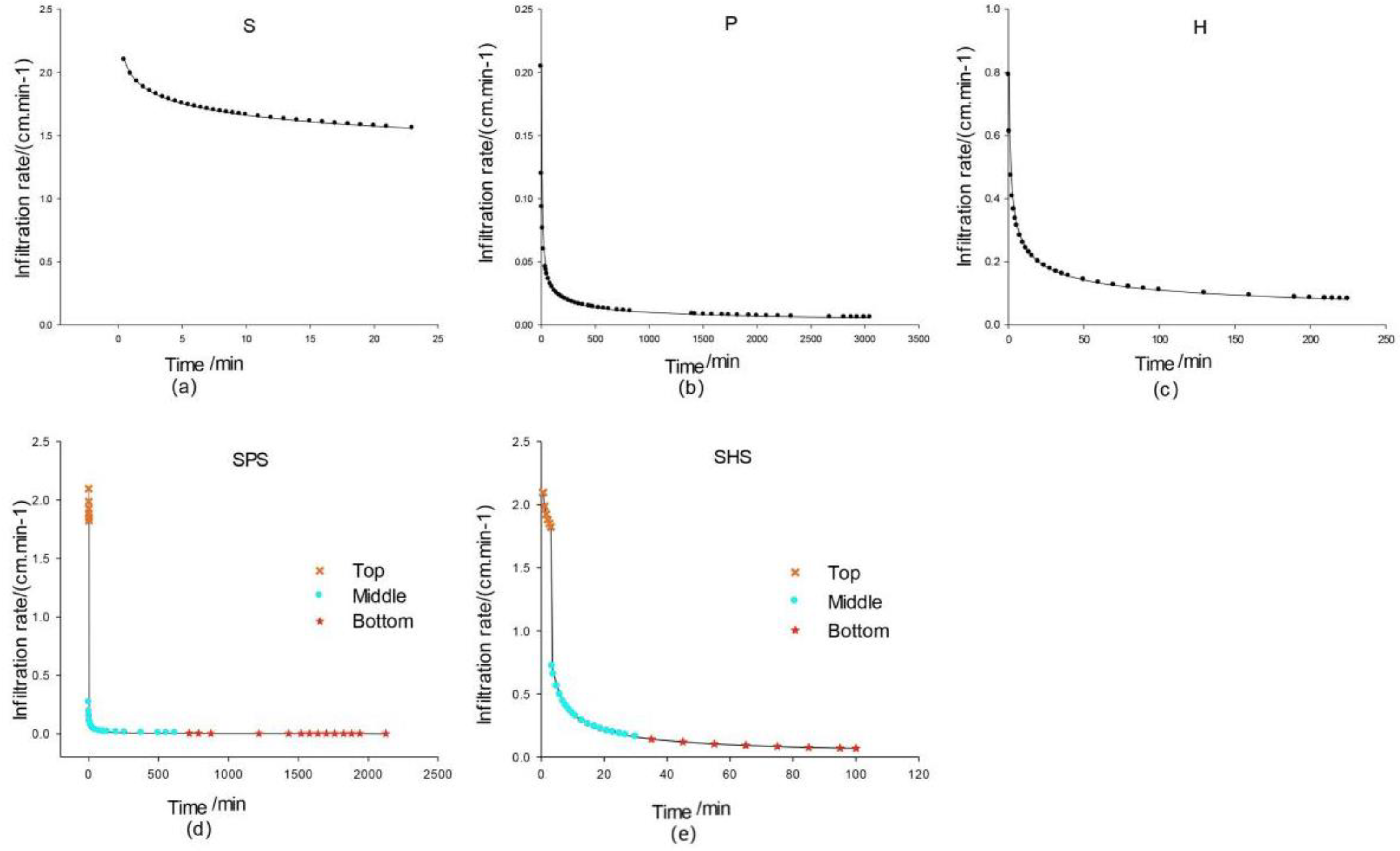
3.1. Simulation of Water Infiltration in Homogeneous Soil

One-dimensional vertical infiltration simulation in the soil has been a heated and productive topic of research for domestic and overseas experts and the simulation formulas could be classified as theoretical models such as the Green–Ampt infiltration model or Philip formula, semi-empirical models such as the Horton and Holtan models, and empirical models such as the Kostiakov and Huggins–Monke models [20,21,22,23]. Zhen et al. (2016) [9] validated that the water infiltration process in homogeneous soil can be effectively fitted by both Philip and Kostiakov infiltration models. To explicitly display the infiltration features in the homogenously-constructed weathered Montmorillonite-enriched sandstone, sandy soil, and their mixture, the Philip model, Horton model, and Kostiakov model were applied to acquire their cumulative water infiltration and the correlation between infiltration time and wetting front (Table 2). The infiltration time was 23 min, 225 min, and 3119 min in the homogenous soils S (three homogeneously-constructed sandy soils), P (Montmorillonite-enriched sandstone), and H (70% sandy soil + 30% Montmorillonite-enriched sandstone mixture), respectively. Results in Table 2 demonstrate that the cumulative water infiltration in the three homogeneous soils could be simulated, among which the Philip model exhibited better fitting performance than the Horton model and Kostiakov model with higher determination coefficients of above 0.995. The chronological change of the wetting front in the three soils could be expressed by a power function, with determination coefficients of no less than 0.962.
The infiltration rate is the water amount seeping from the soil surface to soil on a given unit of area within a fixed period of time. It is a depiction of infiltration properties of the soil. Figure 2a–c record the infiltration rates and trends. It can be observed that the infiltration rates of three soils changed significantly with time and when infiltration in treatment P decreased mildly with infiltration time, the rates in treatment S and H dropped radically. Infiltration rates of treatment S, P, and H reached 1.40, 0.006 and 0.80 cm/min when the stable infiltrations were achieved 8 m, 600 m, and 70 m after the tests started. The findings exhibited that the infiltration rate in sandy soil was significantly higher than that of Montmorillonite-enriched sandstone and the addition of Montmorillonite-enriched sandstone into sandy soil notably decreased its infiltration, which could be attributed to the fact that the large number of clay particles in the Montmorillonite-enriched sandstone fill the large pores, changing the pore structure and infiltration properties of the original sandy soil. Previous studies have also shown success in revegetating by mixing Montmorillonite-enriched sandstone with coarse soils from mining sectors in the area. Due to the low and concentrated rainfall in the region, some vegetation die-off, such as sea-buckthorn and alfalfa, has been observed, which may be attributed in part to water shortage. The addition of Montmorillonite-enriched sandstone with high water holding capacity and high diffusivity could increase the water content of the sandy soil, keep the survival of plants in the long-term drying process, and improve the drought-resistant ability of vegetation, which is of great significance for surface soil reclamation in mining areas.

3.2. Simulation of Water Infiltration in Heterogeneous Soil

Simulations of the water infiltration process in heterogeneous soils are much more difficult than those in homogeneous soil due to the remarkable differences between the two and the more complicated infiltration in the former. At the initial stage of infiltration, the wetting fronts advanced speedily because of the coarse texture and lower initial water content in the sandy layer, the same as the infiltration in the homogeneous sandy soil where the cumulative infiltration amount can be simulated by the Kostiakov empirical model and chronological wetting front variance fitted by power function, as can be seen in Table 3. The wetting front did not stagnate when reaching the upper interface of the interlayer, but its advancement speed slowed down because of the heavy fraction of Montmorillonite-enriched sandstone. The cumulative infiltration amount and wetting front change with time could still be simulated by the Kostiakov model and simple power function (Table 3). However, when the wetting front reached the lower interface of the interlayer, a stagnation caused by a water suction of the interlayer soil higher than that of the sandy soil below was detected. With the proceeding of water infiltration, water content at the wetting front increased and the matric suction decreased till it was equal to the suction of sandy soil. Meanwhile, the wetting front continued to migrate downward into the lower sandy soil in finger flow, which is consistent with the findings of Hillel and Parlange [19] (1972) in their study on water infiltration in “fine-to-coarse” heterogeneous soils. Finger flow appeared when the original flat infiltration wetting front was distorted, elongated, and contracted by the uneven surface tension and capillary pressure [24] (Li et al., 2018). In this infiltration stage, a linear increase of cumulative infiltration, known as the stable infiltration, was detected and the infiltration amount was simulated by the linear function I = at + b [25] (Liu et al., 2012), as can be seen in Table 3.
Figure 2d,e show the infiltration rate change with time in heterogeneous soils. At the initial stage, before the wetting front reached the upper interface of the interlayer, it advanced quickly at a high infiltration rate and chronological infiltration rates in both hierarchical soils changed almost the same as that in the homogeneous sandy soil. During the period when the wetting front penetrated the upper interface and reached the lower interface, infiltration rates in the two hierarchical soils decreased rapidly and trended to be stable. Treatment SPS and SHS took 300 and 20 min, respectively, to achieve their stable infiltration rates of 0.006 and 0.07 cm/min, which further dropped to 0.001 and 0.06 cm/min after wetting fronts penetrated the Montmorillonite-enriched sandstone layer in treatment SPS and the mixed interlayer of treatment SHS. The decreasing infiltration rate after the wetting front passes through each interlayer is consistent with the previous research results.

3.3. Dynamics of Soil Water Content at Different Depth

Figure 3 illustrates the soil water content curves detected by the TDR-315L sensor probes set at various depths of homogeneous and heterogeneous soils. Although soil columns were prepared according to the unified initial water content and bulk density, the measured values of initial water content and saturated water content by probes at different soil depths varied, which might be caused by environmental factors and systematic errors of moisture transducers.
As can be seen from Figure 3a–c, in the infiltration process of homogeneous soil columns, water content increased significantly from the upper layer to lower layers and then stabilized, reaching a maximum when the wetting front reached the depths of probes. A comparison of water content determined by probes in the three homogeneous soil columns displayed that after the wetting front, the Montmorillonite-enriched sandstone preserved the highest content of water, followed by sandy soil, and then the Montmorillonite-enriched sandstone + sandy soil mixture. The highest water content in Montmorillonite-enriched sandstone could be attributed to its lower bulk density, higher degree of porosity, and stronger water retention capacity than sandy soil; and the least water content in the mixture of these three homogeneous soils could be explained by its higher air residual after the wetting front.
Figure 3d,e present the water content changes with time and depths of heterogeneous soil columns. Similar to those in homogeneous soils, water content increased significantly from the upper layer to lower layers and the wetting front kept stable and flat in the upper layer and interlayer. However, when reaching the lower soil layer, finger flow occurred and the wetting front appeared random and unstable. Water moved downward in partial regions and water content, far below its saturated water content at a given depth, and rose more quickly with the increase of soil depth.
During the infiltration process, the shallow infiltration of soil water may not meet the demand of plant use but will increase surface runoff and aggravate soil erosion. Deep infiltration may lead to sublayer percolation and may also pollute the underground water and reduce the water use efficiency. Compared with Montmorillonite-enriched sandstone, heterogeneously-constructed soil could reduce runoff, accelerate the infiltration of rainfall to interlayer, slow down the water seepage into deeper soil layers, and retain more water in the surface layer for plant growth. Thereby, soils with high water-holding capacity and low diffusivity could be used as a reservoir in combination with other high-moisture soil materials, and the best reconstructed soil is a mixture of soil with low diffusivity and water-holding capacity (e.g., sandy soil) and soil with high diffusivity and water-holding capacity (e.g., Montmorillonite-enriched sandstone). The infiltration process in heterogeneous soil constructions such as treatment SPS and SHS could provide a theoretical basis for upper soil constructions for refuse dump reclamation of the opencast mines.

4. Conclusions

In this paper, the infiltration process and soil water change in sandy soil with weathered Montmorillonite-enriched sandstone were measured, simulated, and analyzed based on the one-dimensional constant head water infiltration experiments of homogeneously and heterogeneously-constructed soil columns in laboratory. The results demonstrated that the infiltration capacity decreased from treatments S to H, P, SHS, till SPS. The infiltration capacity of Montmorillonite-enriched sandstone was significantly lower than that of sandy soil, and the addition of Montmorillonite-enriched sandstone into sandy soil greatly reduced its infiltration rate. In heterogeneous soils, treatment SPS reduced more infiltration than SHS did.
In the homogeneous soil, the relation between cumulative infiltration amount and infiltration time could be perfectly fitted by conventional empirical models, and the migration distance of the wetting front and infiltration time displayed a sound power functional relation. The cumulative infiltration and migration distance matched the Kostiakov model well and exhibited similar power functional relations in the upper and interlayer of the heterogeneous soil columns. However, in the bottom layer, the infiltration amount displayed a linear increase with infiltration time and the wetting front elongated and contracted, forming finger flows.
After the wetting front, the water content in the upper and interlay of the heterogeneous soil was the same as that in the homogeneous soil and water content in the bottom sandy layer was much lower than its saturated water content, proving that heterogeneous soil construction can reduce the deep percolation and retain more water onto higher layers for plant growth, and that both these two heterogeneous soil constructions can be better choices of soil structure in land reclamation in the refuse dump of opencast mines.
In conclusion, from the perspective of soil water infiltration, a heterogeneously-constructed soil is the best reclamation model for refuse dumps in the opencast mining area of northern China. The results could provide a theoretical basis and reference for soil reclamation in similar mining areas.

Author Contributions

X.Y. and J.J. designed the study, analyzed the data, wrote, and edited the original draft. X.Z. and Y.Z. revised and improved the manuscript. All authors have read and agreed to the published version of the manuscript.

Funding

This work was funded by the Open Research Fund of the State Key Laboratory of Soil Erosion and Dryland Farming on the Loess Plateau (A314021402-2019), and Natural Science Foundation of Shaanxi Province (2022JQ-418).

Institutional Review Board Statement

Not applicable.

Informed Consent Statement

Not applicable.

Conflicts of Interest

The authors declare no conflict of interest.

References

  1. Wang, F.; Wang, J.; Wang, Y. Using multi-fractal and joint multi-fractal methods to characterize spatial variability of reconstructed soil properties in an opencast coal-mine dump in the Loess area of China. Catena 2019, 182, 104111. [Google Scholar] [CrossRef]
  2. Cao, Y.; Wang, B.; Guo, H.; Xiao, H.; Wei, T. The effect of super absorbent polymers on soil and water conservation on the terraces of the loess plateau. Ecol. Eng. 2017, 102, 270–279. [Google Scholar] [CrossRef]
  3. Huang, L.; Zhang, P.; Hu, Y.; Zhao, Y. Vegetation succession and soil infiltration characteristics under different aged refuse dumps at the Heidaigou opencast coal mine. Glob. Ecol. Conserv. 2015, 4, 255–263. [Google Scholar] [CrossRef] [Green Version]
  4. Guan, Y.; Zhou, W.; Bai, Z.; Cao, Y.; Huang, Y.; Huang, H. Soil nutrient variations among different land use types after reclamation in the Pingshuo opencast coal mine on the Loess Plateau, China. Catena 2019, 188, 104427. [Google Scholar] [CrossRef]
  5. Zhang, L.; Qi, R.; Zhang, Y.; Zheng, J.; Zhang, X. Effects of amendment of aeolian sandy soil and loess with soft sandstone on soil water retention curve and evaporation. Acta Pedol. Sin. 2015, 52, 77–86. (In Chinese) [Google Scholar] [CrossRef]
  6. Wang, J.; Zhen, Q.; Xin, J.; Wang, Y.; Zhang, X. Phosphorus removal from aqueous solution using Al-modified Pisha sandstone. J. Clean. Prod. 2021, 308, 127255. [Google Scholar] [CrossRef]
  7. Liang, Z.; Wu, Z.; Yao, W.; Noori, M.; Yang, C.; Xiao, P.; Leng, Y.; Deng, L. Pisha sandstone: Causes, processes and erosion options for its control and prospects. Int. Soil Water Conserv. Res. 2019, 7, 1–8. [Google Scholar] [CrossRef]
  8. Han, J.; Liu, Y.; Luo, L. Research on the core technology of remixing soil by soft rock and sand in the Maowusu sand land region. China Land Sci. 2012, 26, 87–94. (In Chinese) [Google Scholar] [CrossRef]
  9. Zhen, Q.; Zheng, J.; He, H.; Han, F.; Zhang, X. Effects of Pisha sandstone content on solute transport in a sandy soil. Chemosphere 2016, 144, 2214–2220. [Google Scholar] [CrossRef]
  10. Sun, Z.; Han, J. Effect of soft rock amendment on soil hydraulic parameters and crop performance in Mu Us Sandy Land, China. Field Crops Res. 2018, 222, 85–93. [Google Scholar] [CrossRef]
  11. Rooij, G. Modeling fingered flow of water in soils owing to wetting front instability: A review. J. Hydrol. 2000, 231–232, 277–294. [Google Scholar] [CrossRef]
  12. Green, W.H.; Ampt, G.A. Studies on soil physics: I, flow of air and water through soils. J. Agric. Sci. 1911, 4, 1–24. [Google Scholar] [CrossRef]
  13. Kostiakov, A.N. On the dynamics of the coefficient of water percolation in soils and on the necessity of studying it from a dynamic point of view for purpose of amelioration. Trans. 6th Congr. Int. Soil Sci. Soc. Mosc. Part A 1932, 17–21. [Google Scholar]
  14. Horton, R.E. An approach toward a physical interpretation of infiltration capacity. Soil Sci. Soc. Am. J. 1941, 5, 399–417. [Google Scholar] [CrossRef]
  15. Philip, J.R. The theory of infiltration: 2. Profile at infinity. Soil Sci. 1957, 83, 435–448. [Google Scholar] [CrossRef]
  16. Miller, D.E.; Gardner, W.H. Water Infiltration into Stratified Soil. Soil Sci. Soc. Am. J. 1962, 26, 115–119. [Google Scholar] [CrossRef]
  17. Yang, H.; Rahardjo, H.; Leong, E.C.; Fredlund, D.G. A study of infiltration on three sand capillary barriers. Can. Geotech. J. 2004, 41, 629–643. [Google Scholar] [CrossRef]
  18. Wang, C.; Mao, X.; Zhao, B. Experiment and simulation on infiltration into layered soil column with sand interlayer under ponding condition. Trans. Chin. Soc. Agric. Eng. 2010, 26, 61–67. (In Chinese) [Google Scholar] [CrossRef]
  19. Hill, D.E.; Parlange, J.Y. Wetting front instability in layered soils. Soil Sci. Soc. Am. J. 1972, 36, 697–702. [Google Scholar] [CrossRef]
  20. Mishra, S.K.; Tyagi, J.V.; Singh, V.P. Comparison of infiltration models. Hydrol. Process. 2003, 17, 2629–2652. [Google Scholar] [CrossRef]
  21. Ogbe, V.B.; Jayeoba, O.J.; Ode, S.O. Comparison of four soil infiltration models on a sandy soil in Lafia, Southern Guinea Savanna Zone of Nigeria. Prod. Agric. Technol. 2011, 7, 116–126. [Google Scholar]
  22. Sihag, P.; Tiwari, N.K.; Ranjan, S. Modelling of infiltration of sandy soil using gaussian process regression. Model. Earth Syst. Environ. 2017, 3, 1091–1100. [Google Scholar] [CrossRef]
  23. Zakwan, M. Comparative analysis of the novel infiltration model with other infiltration models. Water Environ. J. 2019, 33, 620–632. [Google Scholar] [CrossRef]
  24. Li, Y.; Ren, X.; Hill, R.; Malone, R.; Zhao, Y. Characteristics of Water Infiltration in Layered Water-Repellent Soils. Pedosphere 2018, 28, 775–792. [Google Scholar] [CrossRef]
  25. Liu, Y.; Zhang, X. Effects of EN-1 soil stabilizer on water vertical infiltration characteristics for loess stabilized soil. Trans. Chin. Soc. Agric. Mach. 2012, 43, 65–73. (In Chinese) [Google Scholar] [CrossRef]
Figure 1. Schematic diagram of experimental setup.
Sustainability 14 15929 g001
Figure 2. Chronological changes of infiltration rate in different treatments. Notes: S was sandy soil, P was Montmorillonite-enriched sandstone, H was 70% sandy soil + 30% Montmorillonite-enriched sandstone mixture, SPS was sandy layer + Montmorillonite-enriched sandstone layer + sandy layer, SHS was sandy layer + 7:3 sandy-Montmorillonite-enriched sandstone mixture layer + sandy layer. Top was the top layer of heterogeneous soils, middle was the interlayer of heterogeneous soils, bottom was the bottom layer of heterogeneous soils.
Sustainability 14 15929 g002
Figure 3. Changes of water content in soil profile in different treatments.
Sustainability 14 15929 g003
Table 1. Particle composition of soils used in the experiments.
MaterialsMethodsSoil Texture
Sand (%)Silt (%)Clay (%)
Sandy soilA90.332.667.01
B96.82.530.67
Montmorillonite-enriched sandstoneA43.332.1724.53
B28.9559.4111.64
Notes: A, pipette method; B, laser method.
Table 2. Infiltration parameters of homogeneous soils.
InfiltrationModelS (Three Homogeneously-Constructed Sandy Soil)P(Montmorillonite-Enriched Sandstone)H( 70% sandy soil +30% Montmorillonite-Enriched Sandstone Mixture)
Cumulative infiltration IPhilip I = 1.907 t 0.5 + 1.183t
R 2 = 0.9997
I = 0.59 t 0.5 + 0.0005t
R 2 = 0.9999
I = 1.199 t 0.5 + 0.045t
R 2 = 0.9999
Kostiakov I = 2.702 t 0.825
R 2 = 0.9980
I = 0.5554 t 0.5126
R 2 = 0.9999
I = 0.9594 t 0.6211
R 2 = 0.9986
Horton I = 0.8647 t   +
18.94   ( 1 e 0.0723 t )
R 2 = 0.9949
I = 0.0078 t   +
11.02   ( 1 e 0.0051 t )
R 2 = 0.9990
I = 0.0959 t   +
6.77   ( 1 e 0.0496 t )
R 2 = 0.9986
Wetting   front   Z f z f = 7.7817 t 0.8052
R 2 = 0.9615
z f = 1.9074 t 0.4936
R 2 = 0.9980
z f = 2.7840 t 0.6567
R 2 = 0.9974
Notes: I was the cumulative infiltration (cm), t was the infiltration time (minutes), z f was the wetting front in cm and R2 was the determination coefficient. S was sandy soil, P was Montmorillonite-enriched sandstone, H was 70% sandy soil + 30% Montmorillonite-enriched sandstone mixture.
Table 3. Infiltration parameters of heterogeneous soils.
TreatmentsCumulative Infiltration I Wetting   Front   z f
SPSTop layer I = 1.818 t 1.051
R 2 = 0.9993
z f = 8.598 t 0.6936
R 2 = 0.9944
Interlayer I = 5.4918 t 0.1605
R 2 = 0.9404
z f = 12.810 t 0.2006
R 2 = 0.9971
Bottom layer I = 0.0053t + 13.84
R 2 = 0.9971
SHSTop layer I = 1.809 t 1.709
R 2 = 0.9986
z f = 8.596 t 0.7498
R 2 = 0.9971
Interlayer I = 4.720 t 0.3613
R 2 = 0.9949
z f = 13.750 t 0.3795
R 2 = 0.9988
Bottom layer I = 0.1919t + 10.20
R 2 = 0.9999
Note: SPS was sandy layer + Montmorillonite-enriched sandstone layer + sandy layer, SHS was sandy layer + 7:3 sandy-Montmorillonite-enriched sandstone mixture layer + sandy layer.
Publisher’s Note: MDPI stays neutral with regard to jurisdictional claims in published maps and institutional affiliations.

