
Quantifying Mangrove Extent Using a Combination of Optical and Radar Images in a Wetland Complex, Western Region, Ghana


Abstract
1. Introduction
2. Materials and Methods
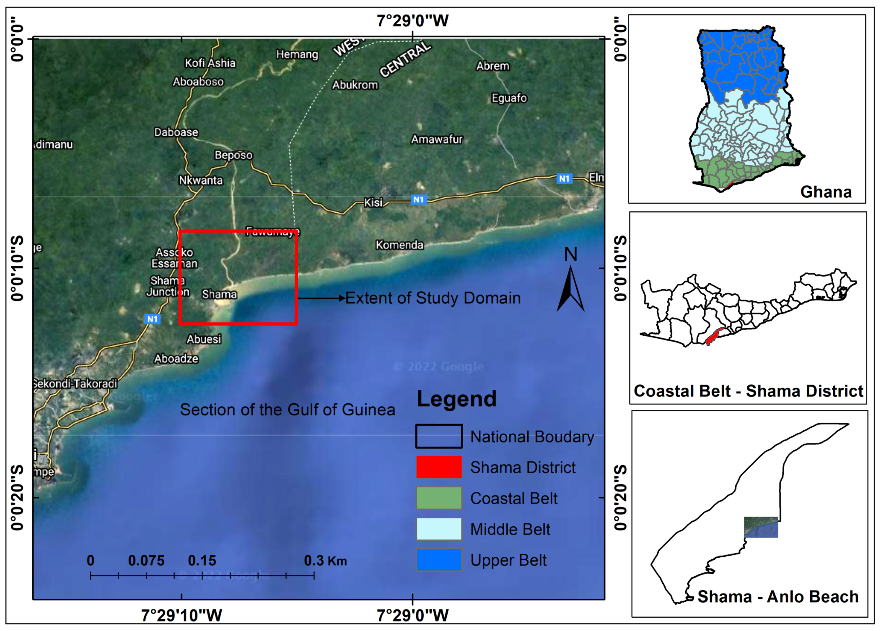
2.1. Study Location
2.2. Datasets and Sources
2.3. Comparison of Mangrove Extents
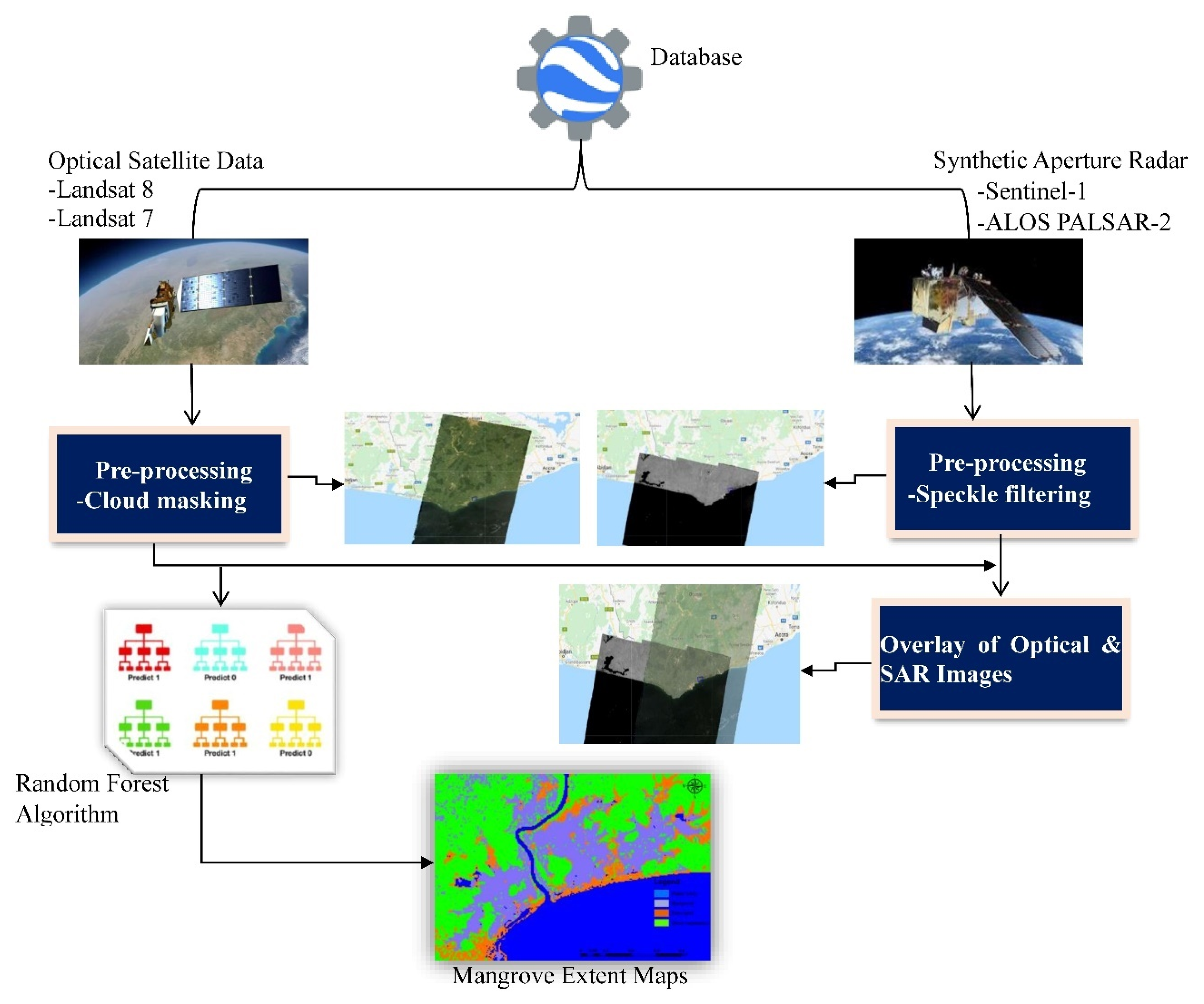
2.3.1. Mangrove Extent Mapping
2.3.2. Construction of Random Forest Model
2.3.3. Synthetic Aperture Radar (SAR) Classification
2.3.4. Landsat Image Classification
2.3.5. Both Landsat and SAR Classification
2.3.6. Time Series Comparison
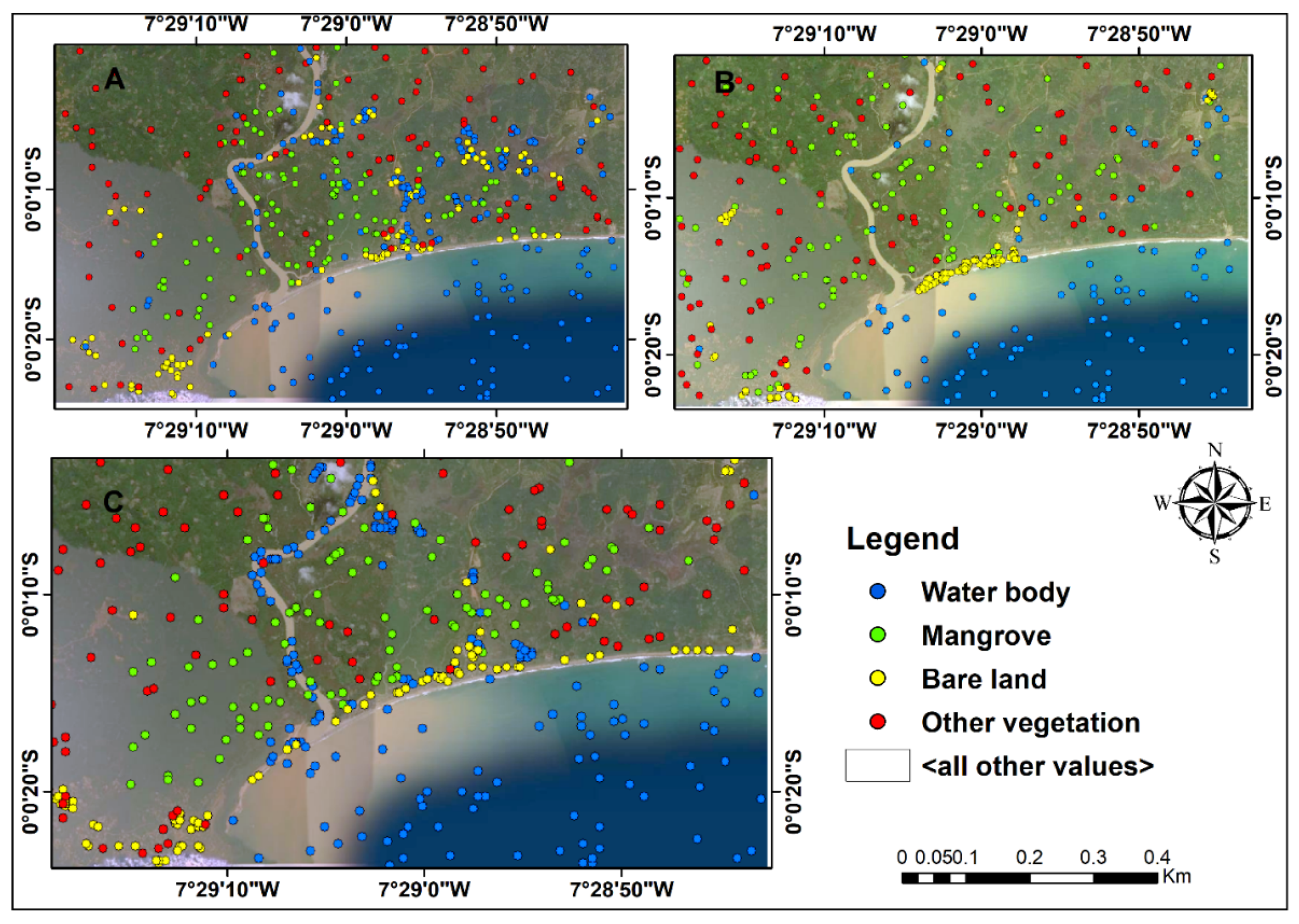
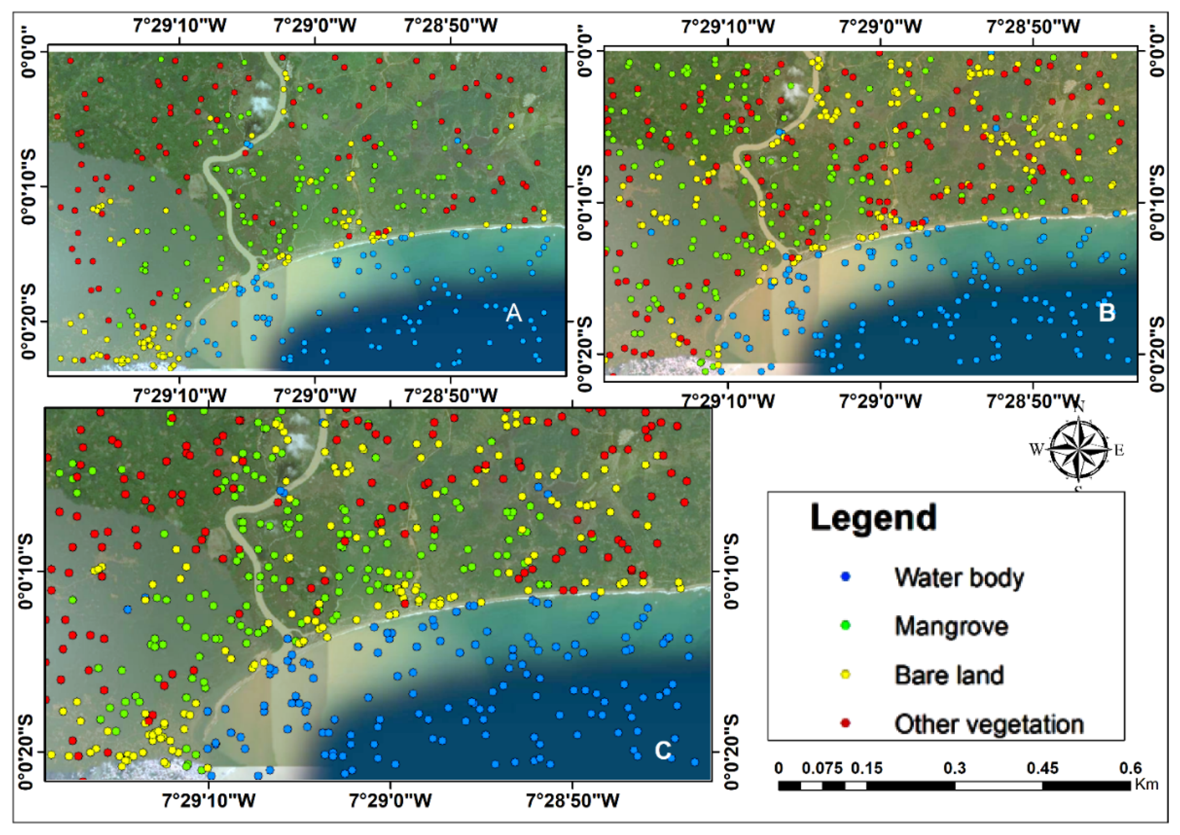
2.3.7. Independent Accuracy Assessment
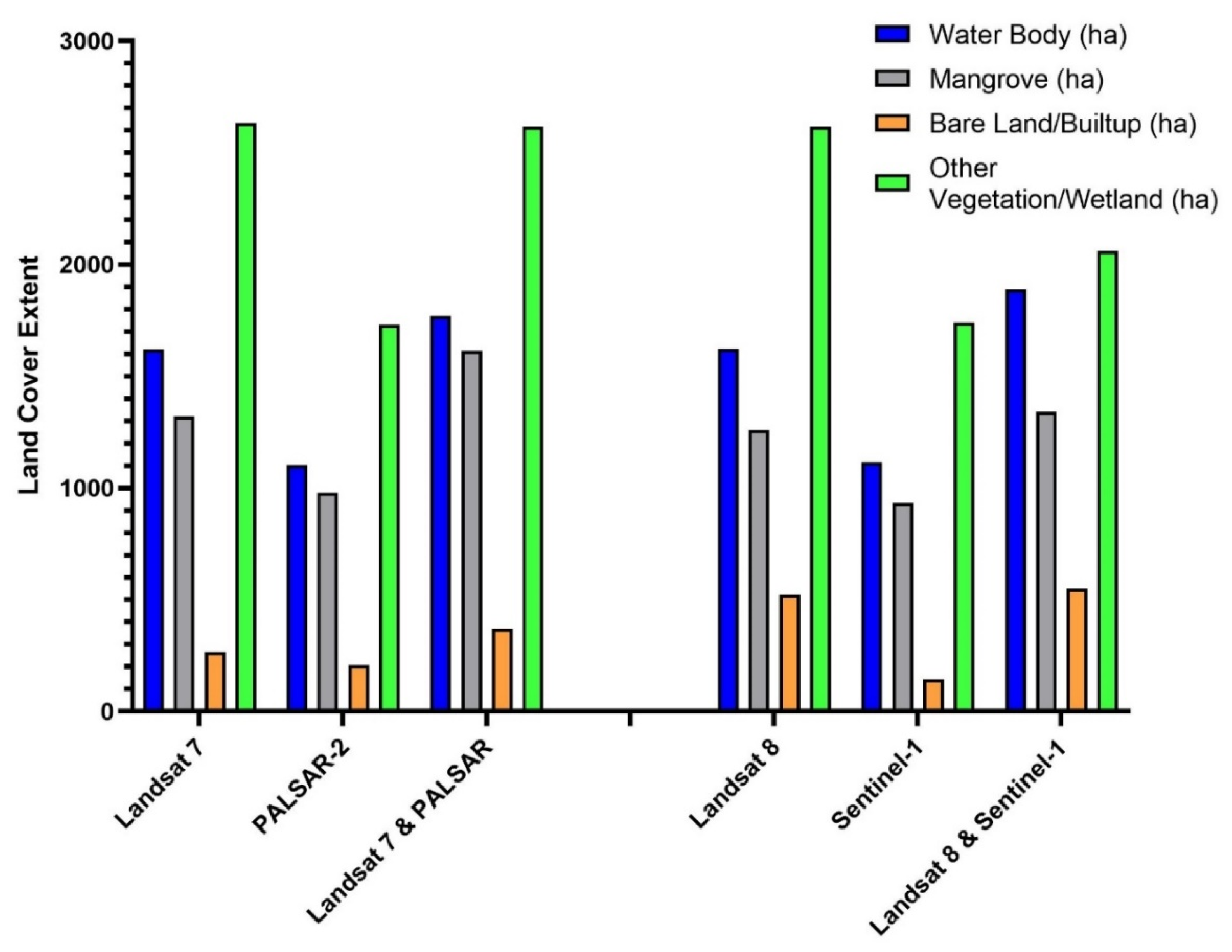
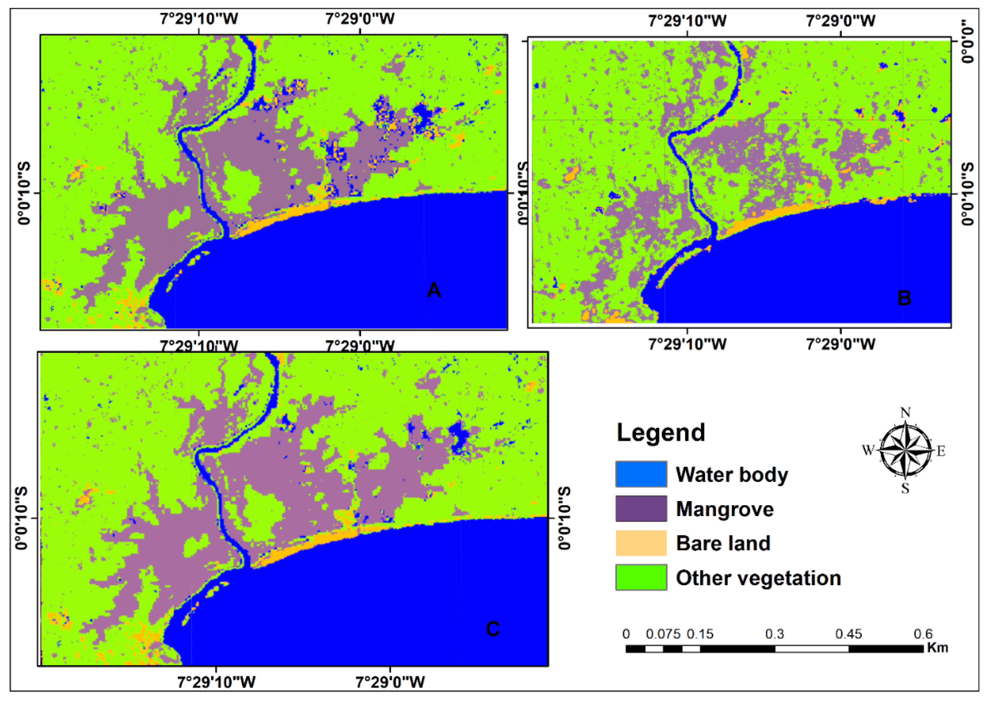
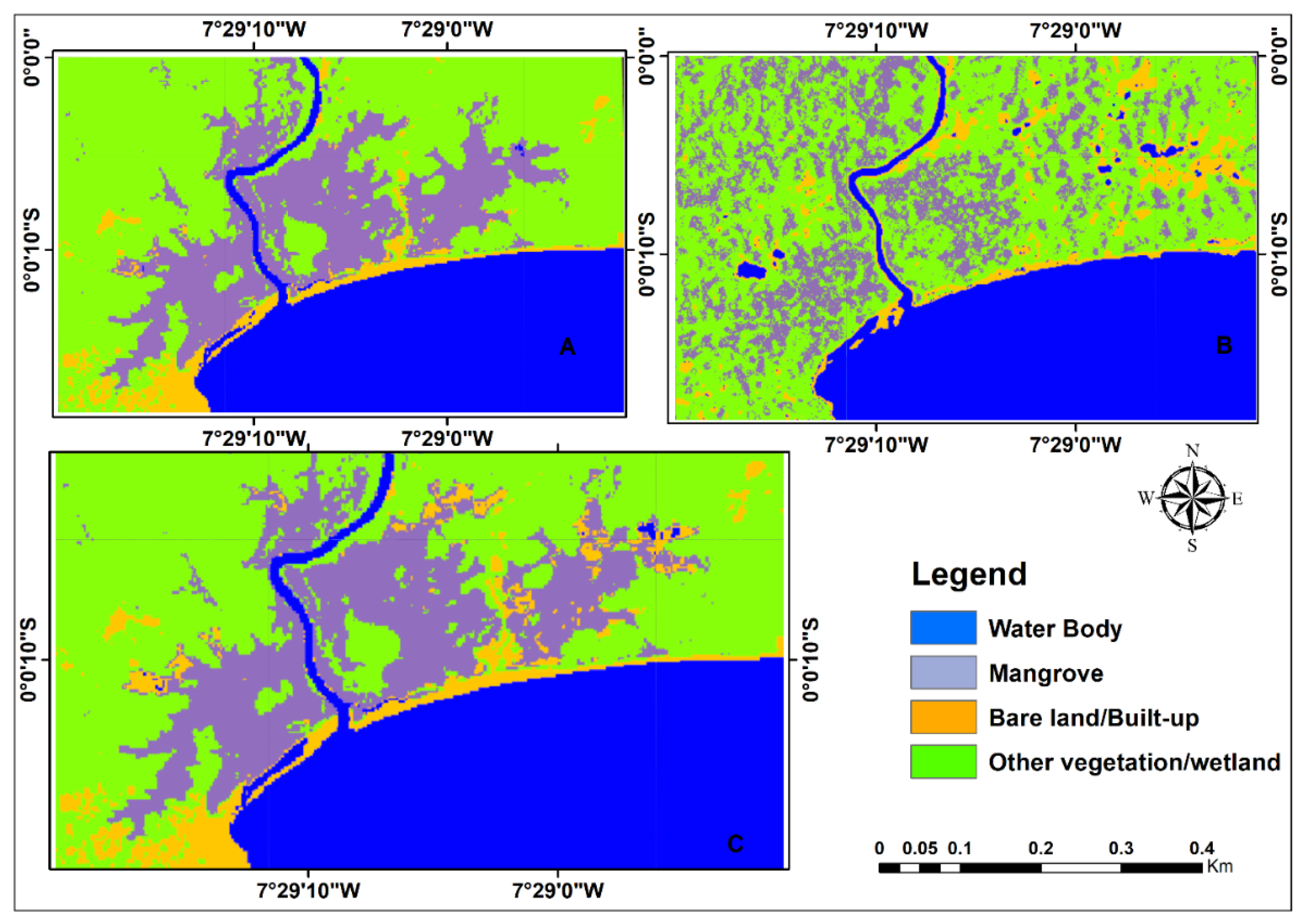
3. Results
4. Discussion
5. Conclusions
Author Contributions
Funding
Institutional Review Board Statement
Informed Consent Statement
Data Availability Statement
Acknowledgments
Conflicts of Interest
Abbreviations
| ALOS | Advanced land observation satellite |
| ETM+ | Enhanced thematic mapper |
| GEE | Google Earth Engine |
| HH | Single co-polarization, horizontal transmit/horizontal receive |
| NDVI | Normalized difference vegetation index |
| PALSAR | Phase array L-band synthetic aperture radar |
| SAR | Synthetic aperture radar |
| SDGs | Sustainable development goals |
| VV | Single co-polarization, vertical transmit/vertical receive |
References
- Blasco, F.; Aizpuru, M.; Besnehard, J. Mangroves, Ecology. Encyclopedia of Coastal Science; Finkl, W.C., Makowski, C., Eds.; Springer Nature Switzerland AG: Cham, Switzerland, 2019. [Google Scholar] [CrossRef]
- Maurya, K.; Mahajan, S.; Chaube, N. Remote sensing techniques: Mapping and monitoring of mangrove ecosystem—A review. Complex Intell. Syst. 2021, 7, 2797–2818. [Google Scholar] [CrossRef]
- Erika, P.; Amber, M.; Juan, L.; Torres, P.; Sean, M. Forest Mapping and Monitoring with SAR Data: Time Series Analysis; NASA’s Applied Remote Sensing Training Program: Baltimore, MD, USA, 2020. Available online: https://arset.gsfc.nasa.gov/land/webinars/forest-mapping-sar (accessed on 14 May 2020).
- Lucas, R.; Rebelo, L.; Fatoyinbo, L.; Rosenqvist, A.; Itoh, T.; Shimada, M.; Simard, M.; Pedro, W.S.; Nathan, T.; Carl, T.; et al. Contribution of L-Band SAR to systematic global mangrove monitoring. Mar. Freshw. Res. 2014, 65, 589–603. [Google Scholar] [CrossRef]
- Bunting, P.; Rosenqvist, A.; Lucas, R.M.; Rebelo, L.M.; Hilarides, L.; Thomas, N.; Hardy, A.; Itoh, T.; Shimada, M.; Finlayson, C.M. The global mangrove watch—A new 2010 global baseline of mangrove extent. Remote Sens. 2018, 10, 1669. [Google Scholar] [CrossRef]
- Gedan, K.B.; Kirwan, M.L.; Wolanski, E.; Barbier, E.B.; Silliman, B.R. The present and future role of coastal wetland vegetation in protecting shorelines: Answering recent challenges to the paradigm. Clim. Chang. 2011, 106, 7–29. [Google Scholar] [CrossRef]
- Kuenzer, C.; Tuan, V.Q. Assessing the ecosystem services value of Can Gio mangrove biosphere reserve: Combining earth-observation- and household-survey-based analyses. Appl. Geogr. 2013, 45, 167–184. [Google Scholar] [CrossRef]
- Lee, S.Y.; Primavera, J.H.; Dahdouh-Guebas, F.; McKee, K.; Bosire, J.O.; Cannicci, S.; Diele, K.; Fromard, F.; Koedam, N.; Marchand, C. Ecological role and services of tropical mangrove ecosystems: A reassessment: Reassessment of mangrove ecosystem services. Glob. Ecol. Biogeogr. 2014, 23, 726–743. [Google Scholar] [CrossRef]
- Mondal, P.; Trzaska, S.; de Sherbinin, A. Landsat-derived estimates of mangrove extents in the Sierra Leone coastal landscape complex during 1990. Sensors 2018, 18, 12. [Google Scholar] [CrossRef]
- Fatoyinbo, T.E.; Simard, M. Height and biomass of mangroves in Africa from ICESat/GLAS and SRTM. Int. J. Remote Sens. 2012, 34, 668–681. [Google Scholar] [CrossRef]
- Ellison, A.; Farnsworth, E.; Moore, G. Rhizophora Mangle. The IUCN Red List of Threatened Species. 2015. Available online: http://www.iucnredlist.org/details/178851/0 (accessed on 1 December 2020).
- Nortey, D.D.N.; Aheto, D.W.; John, B.; Fredrick, E.J.; Asare, N.K. Comparative assessment of mangrove biomass and fish assemblages in an urban and rural mangrove wetlands in Ghana. Wetlands 2016, 36, 717–730. [Google Scholar] [CrossRef]
- Alongi, D.M. Carbon sequestration in mangrove forests. Carbon Manag. 2012, 3, 313–322. [Google Scholar] [CrossRef]
- Breithaupt, J.; Smoak, J.M.; Smith, T.J.; Sanders, C.; Hoare, A. Organic carbon burial rates in mangrove sediments: Strengthening the global budget. Glob. Biogeochem. Cycles 2012, 26, GB3011. [Google Scholar] [CrossRef]
- Mayaux, P.; Holmgren, P.; Achard, F.; Eva, H.; Stibig, H.J.; Branthomme, A. Tropical forest cover change in the 1990s and options for future monitoring. Philos. Trans. R. Soc. Lond. B Biol. Sci. 2005, 360, 373–384. [Google Scholar] [CrossRef] [PubMed]
- FAO. The World’s Mangroves 1980—FAO Forestry Paper; Forest Resources Division: Rome, Italy, 2007; p. 77. [Google Scholar]
- Miththapala, S. Mangroves. Coastal Ecosystems Series Volume 2 pp 1–28 + iii, Colombo, Sri Lanka: Ecosystems and Livelihoods Group Asia, IUCN. 2008. Available online: https://portals.iucn.org/library/node/9146 (accessed on 5 November 2020).
- World Mangrove Network. Western Indian Ocean Mangrove Network/United States Forest Service Workshop Report, Maputo, Mozambique. 2012. Available online: https://www.un.org/Depts/los/global_reporting/assessments_Workshops_2013/Assessment_Workshop_Mozambique.pdf (accessed on 12 December 2020).
- Zhang, C.; Kovacs, J.M.; Liu, Y.; Flores-Verdugo, F.; Flores-De-Santiago, F. Separating mangrove species and conditions using laboratory hyperspectral data: A case study of a degraded mangrove Forest of the Mexican Pacific. Remote Sens. 2014, 6, 11673–11688. [Google Scholar] [CrossRef]
- Son, N.T.; Chen, C.F.; Chang, N.B.; Chen, C.R.; Chang, L.Y.; Thanh, B.X. Mangrove mapping and change detection in Ca Mau Peninsula, Vietnam, using landsat data and object-based image analysis. IEEE J. Sel. Top. Appl. Earth Obs. Remote Sens. 2015, 8, 503–510. [Google Scholar] [CrossRef]
- Attarchi, S.; Gloaguen, R. Classifying complex mountainous forests with L-Band SAR and landsat data integration: A comparison among different machine learning methods in the Hyrcanian Forest. Remote Sens. 2014, 6, 3624–3647. [Google Scholar] [CrossRef]
- Ayman, A.H.; Olena, D.; Islam, A.E.; Gunter, M. Integration of SAR and optical remote sensing data for mapping of mangroves extents. In From Science to Society: The Bridge Provided by Environmental Informatics; Otjacques, B., Hitzelberger, P., Naumann, S., Wohlgemuth, V., Eds.; Shaker Verlag GmbH: Düren, Germany, 2017; pp. 1–8. [Google Scholar]
- Hu, T.; Ying, Y.Z.; Yanjun, S.; Yi, Z.; Guanghui, L.; Qinghua, G. Mapping the global mangrove forest aboveground biomass using multisource remote sensing data. Remote Sens. 2020, 12, 1690. [Google Scholar] [CrossRef]
- Ghorbanian, A.; Zaghian, S.; Asiyabi, R.; Amani, M.; Mohammadzadeh, A.; Jamali, S. Mangrove ecosystem mapping using Sentinel-1 and Sentinel-2 satellite images and random forest algorithm in Google Earth engine. Remote Sens. 2021, 13, 2565. [Google Scholar] [CrossRef]
- Yancho, J.; Jones, T.; Gandhi, S.; Ferster, C.; Lin, A.; Glass, L. The Google Earth Engine Mangrove Mapping Methodology (GEEMMM). Remote Sens. 2020, 12, 3758. [Google Scholar] [CrossRef]
- Beselly, S.; van der Wegen, M.; Grueters, U.; Reyns, J.; Dijkstra, J.; Roelvink, D. Eleven years of mangrove–Mudflat dynamics on the mud volcano-induced prograding delta in East Java, Indonesia: Integrating UAV and satellite imagery. Remote Sens. 2021, 13, 1084. [Google Scholar] [CrossRef]
- Gislason, P.O.; Benediktsson, J.A.; Sveinsson, J.R. Random forest classification of multisource remote sensing and geographic data. In Proceedings of the 2004 IEEE International Geoscience and Remote Sensing Symposium, IGARSS’04, Anchorage, AK, USA, 20–24 September 2004; pp. 20–24. [Google Scholar]
- Ghorbanian, A.; Kakooei, M.; Amani, M.; Mahdavi, S.; Mohammadzadeh, A.; Hasanlou, M. Improved land cover map of Iran using sentinel imagery within Google Earth engine and a novel automatic workflow for land cover classification using migrated training samples. ISPRS J. Photogramm. Remote Sens. 2020, 167, 276–288. [Google Scholar] [CrossRef]
- De Santiago, F.F.; Kovacs, J.M.; Lafrance, P. An object-oriented classification method for mapping mangroves in Guinea, West Africa, using multipolarized ALOS PALSAR L-Band data. Int. J. Remote Sens. 2012, 34, 563–586. [Google Scholar] [CrossRef]
- Farr, T.G.; Rosen, P.A.; Caro, E.; Crippen, R.; Duren, R.; Hensley, S.; Kobrick, M.; Paller, M.; Rodriguez, E.; Roth, L.; et al. The Shuttle Radar Topography Mission. Rev. Geophys. 2007, 45, RG2004. [Google Scholar] [CrossRef]
- Kovacs, J.M.; de Santiago, F.F.; Bastien, J.; Lafrance, P. An assessment of mangroves in Guinea, West Africa, using a field and remote sensing based approach. Wetlands 2010, 30, 773–782. [Google Scholar] [CrossRef]
- Omo-Irabor, O.O.; Olobaniyi, S.B.; Akunna, J.; Venus, V.; Maina, J.M.; Paradzayi, C. Mangrove vulnerability modelling in parts of Western Niger Delta, Nigeria using satellite images, GIS techniques and Spatial Multi-Criteria Analysis (SMCA). Environ. Monit. Assess. 2011, 178, 39–51. [Google Scholar] [CrossRef]
- Otero, V.; Quisthoudt, K.; Koedam, N.; Dahdouh-Guebas, F. Mangroves at their limits: Detection and area estimation of mangroves along the Sahara Desert Coast. Remote Sens. 2016, 8, 512. [Google Scholar] [CrossRef]
- Salami, A.T.; Akinyede, J.; de Gier, A. A preliminary assessment of NigeriaSat-1 for sustainable mangrove forest monitoring. Int. J. Appl. Earth Obs. Geoinf. 2010, 12, S18–S22. [Google Scholar] [CrossRef]
- Hoppe-Speer, S.C.; Adams, J.B.; Rajkaran, A. Mangrove expansion and population structure at a planted site, East London, South Africa. South. For. J. For. Sci. 2015, 77, 131–139. [Google Scholar] [CrossRef]
- Lagomasino, D.; Fatoyinbo, T.; Lee, S.K.; Feliciano, E.A.; Trettin, C.; Shapiro, A.C.; Mangora, M.M. Measuring mangrove carbon loss and gain in deltas. Environ. Res. Lett. 2019, 14, 025002. [Google Scholar] [CrossRef]
- Barenblitt, A.; Fatoyinbo, L. Intro to SDG 6.6 and Remote Sensing Techniques for Mangroves. NASA’s Applied Remote Sensing Training Program. 2020. Available online: https://www.google.com.hk/url?sa=t&rct=j&q=&esrc=s&source=web&cd=&cad=rja&uact=8&ved=2ahUKEwjV56yDv7T7AhVqmWoFHYjED5sQFnoECAoQAQ&url=http%3A%2F%2Fappliedsciences.nasa.gov%2Fsites%2Fdefault%2Ffiles%2F2020-10%2FPart1SDG6_Final.pdf&usg=AOvVaw0tzTfA_Z_yaPzqMnUyDaRe (accessed on 5 November 2020).
- Mondal, P.; Liu, X.; Fatoyinbo, T.E.; Lagomasino, D. Evaluating Combinations of Sentinel-2 Data and Machine-Learning Algorithms for mangrove mapping in West Africa. Remote Sens. 2019, 11, 2928. [Google Scholar] [CrossRef]
- Friends of the Nation. Assessment of Flora and Fauna of Ecological and Socioeconomic Significance within the Anlo Beach Wetland Complex for Improved Management and Livelihood Outcomes, Parks and Gardens, Adiembra; Friends of the Nation: Takoradi, Ghana, 2014; 60p. [Google Scholar]
- Bessah, E.; Raji, A.O.; Taiwo, O.J.; Agodzo, S.K.; Ololade, O.O. Variable resolution modeling of near future mean temperature changes in the dry sub-humid region of Ghana. Model. Earth Syst. Environ. 2018, 4, 919–933. [Google Scholar] [CrossRef]
- Kottek, M.; Grieser, J.; Beck, C.; Rudolf, B.; Rubel, F. World map of the Kppen-Geiger climate classification updated. Meteorol. Z. 2006, 15, 259–263. [Google Scholar]
- Kwabena, K.Y.; Obuobie, E.; Amisigo, B.; Opoku-Ankomah, Y. Impact of climate change on streamflow in selected river basins in Ghana. Hydrol. Sci. J. 2013, 58, 773–788. [Google Scholar] [CrossRef]
- Bessah, E.; Raji, A.O.; Taiwo, O.J.; Agodzo, S.K.; Ololade, O.O. The impact of varying spatial resolution of climate models on future rainfall simulations in the Pra River Basin (Ghana). J. Water Clim. Chang. 2019, 11, 1263–1283. [Google Scholar] [CrossRef]
- Ross, C.W.; Prihodko, L.; Anchang, J.; Kumar, S.; Ji, W.; Hanan, N.P. Global Hydrologic Soil Groups (HYSOGs250m) for Curve Number-Based Runoff Modeling; ORNL DAAC: Oak Ridge, TN, USA, 2018. [Google Scholar] [CrossRef]
- Bessah, E.; Raji, A.O.; Taiwo, O.J.; Agodzo, S.K.; Ololade, O.O.; Strapasson, A. Hydrological responses to climate and land use changes: The paradox of regional and local climate effect in the Pra River Basin of Ghana. J. Hydrol. Reg. Stud. 2019, 27, 100654. [Google Scholar] [CrossRef]
- Coastal Resources Center/Friends of the Nation. Report on Characterization of Coastal Communities and Shoreline Environments in the Western Region of Ghana. Integrated Coastal and Fisheries Governance Initiative for the Western Region of Ghana; Coastal Resources Center, University of Rhode Island: Kingston, RI, USA, 2010; 425p. [Google Scholar]
- Okyere, I. Influence of diurnal tides and other physico-chemical factors on the assemblage and diversity of fish species in River Pra Estuary, Ghana. Trop. Ecol. 2018, 59, 83–90. [Google Scholar]
- JAXA. ALOS-2/Calibration Result of JAXA Standard Products (ver. 2014.11.20, Initial Calibration Results). 2006. Available online: https://www.eorc.jaxa.jp/ALOS-2/en/calval/calval_index_20141120.htm (accessed on 9 October 2021).
- Lavalle, M.; Wright, T. Absolute Radiometric and Polarimetric Calibration of ALOS PALSAR Products. Available online: https://earth.esa.int/eogateway/documents/20142/37627/ALOS-PALSAR-calibration-products-ADEN.pdf?category=Document+library (accessed on 10 December 2020).
- Giri, C.; Ochieng, E.; Tieszen, L.L.; Zhu, Z.; Singh, A.; Loveland, T.; Masek, J.; Duke, N. Status and distribution of mangrove forests of the world using earth observation satellite data. Glob. Ecol. Biogeogr. 2011, 20, 154–159. [Google Scholar] [CrossRef]
- Hansen, M.C.; Potapov, P.V.; Moore, R.; Hancher, M.; Turubanova, S.A.; Tyukavina, A.; Thau, D.; Stehman, S.V.; Goetz, S.J.; Loveland, T.R. High-resolution global maps of 21st century forest cover change. Science 2013, 342, 850–853. [Google Scholar] [CrossRef]
- Nathan, T.; Peter, B.; Richard, L.; Andy, H.; Ake, R.; Fatoyinbo, T.E. Mapping mangrove extent and change: A globally applicable approach. Remote Sens. 2018, 10, 1466. [Google Scholar] [CrossRef]
- Shi, T.; Jue, L.; Zhongwen, H.; Huizeng, L.; Junjie, W.; Guofeng, W. New spectral metrics for mangrove forest identification. Remote Sens. Lett. 2016, 7, 885. [Google Scholar] [CrossRef]
- Pelletier, C.; Valero, S.; Inglada, J.; Champion, N.; Dedieu, G. Assessing the robustness of random forests to map land cover with high resolution satellite image time series over large areas. Remote Sens. Environ. 2016, 187, 156–168. [Google Scholar] [CrossRef]
- Shelestov, A.; Lavreniuk, M.; Kussul, N.; Novikov, A.; Skakun, S. Exploring Google Earth engine platform for big data processing: Classification of multi-temporal satellite imagery for crop mapping. Front. Earth Sci. 2017, 5, 17. [Google Scholar] [CrossRef]
- Barenblitt, A.; Fatoyinbo, L. Mangrove Extent Mapping and Time Series; NASA’s Applied Remote Sensing Training Program: Baltimore, MD, USA, 2020. Available online: https://www.google.com.hk/url?sa=t&rct=j&q=&esrc=s&source=web&cd=&cad=rja&uact=8&ved=2ahUKEwiFl9eWv7T7AhXtlWoFHel4ATMQFnoECA0QAQ&url=https%3A%2F%2Fappliedsciences.nasa.gov%2Fsites%2Fdefault%2Ffiles%2F2020-10%2FPart2Extent_Final.pdf&usg=AOvVaw2mHlG5BrJiWmpJ4N7MHyBG (accessed on 5 November 2020).
- Pimple, U.; Simonetti, D.; Sitthi, A.; Pungkul, S.; Leadprathom, K.; Skupek, H.; Som-ard, J.; Gond, V.; Towprayoon, S. Google Earth engine based three decadal landsat imagery analysis for mapping of mangrove forests and its surroundings in the Trat Province of Thailand. J. Comput. Commun. 2018, 6, 247–264. [Google Scholar] [CrossRef]
- Mwita, E.; Menz, G.; Misana, S.; Nienkemper, P. Detection of small wetlands with multi sensor data in East Africa. Adv. Remote Sens. 2012, 1, 64–73. [Google Scholar] [CrossRef]
- Wijedasa, L.S.; Sloan, S.; Michelakis, D.G.; Clements, G.R. Overcoming limitations with landsat imagery for mapping of Peat Swamp Forests in Sundaland. Remote Sens. 2012, 4, 2595–2618. [Google Scholar] [CrossRef]
- Jhonnerie, R.; Siregar, V.P.; Nababan, B.; Prasetyo, L.B.; Wouthuyzen, S. Random forest classification for mangrove land cover mapping using landsat 5 TM and Alos Palsar imageries. Procedia Environ. Sci. 2015, 24, 215–221. [Google Scholar] [CrossRef]
- Midekisa, A.; Holl, F.; Savory, D.J.; Andrade-Pacheco, R.; Gething, P.; Bennett, A.; Sturrock, H. Mapping land cover change over continental Africa using Landsat and Google Earth Engine cloud computing. PLoS ONE 2017, 12, e0184926. [Google Scholar] [CrossRef]
- Carreiras, J.M.B.; Melo, J.M.; Vasconcelos, M.J. Estimating the above-ground biomass in Miombo Savanna woodlands (Mozambique, East Africa) using L-Band synthetic aperture radar data. Remote Sens. 2013, 5, 1524–1548. [Google Scholar] [CrossRef]
- Ming, D.; Zhou, T.; Wang, M.; Tian, T. Land cover classification using random forest with genetic algorithm-based parameter optimization. J. Appl. Remote Sens. 2016, 10, 035021. [Google Scholar] [CrossRef]
- Phan, T.N.; Kuch, V.; Lehnert, L.W. Land cover classification using Google Earth engine and random forest classifier—The role of image composition. Remote Sens. 2020, 12, 2411. [Google Scholar] [CrossRef]


| S/N | Data Type & Date | Description | Source |
|---|---|---|---|
| 1 | Sentinel-1 (2019) | A synthetic aperture radar (C-Band) with interferometric wide swath mode (IW), having a descending pass, a resolution of 25 m, dual polarization of VV and VH. Image Collection ID: ee.ImageCollection(“COPERNICUS/S1_GRD”), more details can be found at https://developers.google.com/earth-engine/guides/sentinel1 (accessed on 30 November 2020) | Google Earth Engine platform database |
| 2 | ALOS PALSAR-2 (2009) | A synthetic aperture radar at L-Band, having a 100 × 100 in longitude and latitude, a resolution of 25 m, dual polarization of HH and HV. Image Collection ID: N06W002_09_sl_HH, N06W002_09_sl_HV available at https://www.eorc.jaxa.jp/ALOS-2/en/about/palsar2.htm (accessed on 30 November 2020) | Japan Aerospace Exploration Agency (JAXA) EORC |
| 3 | Landsat 8 Surface Reflectance Tier 1 (2019) | Has been atmospherically corrected and contains five visible and near-infrared bands, two short wave infrared bands, and two thermal infrared bands. Image Collection ID: ee.ImageCollection(‘LANDSAT/LC08/C01/T1_SR’). More details at https://www.usgs.gov/landsat-missions/landsat-surface-reflectance (accessed on 30 November 2020) | Google Earth Engine platform database |
| 4 | Landsat 7 Surface Reflectance Tier 1 (2009) | Has been atmospherically corrected and contains four visible and near-infrared bands, two short wave infrared bands, and one thermal infrared band. Image Collection ID: ee.ImageCollection(“LANDSAT/LE07/C01/T1_SR”) More details at https://www.usgs.gov/landsat-missions/landsat-surface-reflectance (accessed on 30 November 2020) | Google Earth Engine platform database |
| 5 | Global mangrove distribution vector (GMW) (2010) | A baseline global distribution map of mangroves for year 2010. GMW was produced by Aberystwyth University in collaboration with solo earth observation (soloEO). It provides geospatial information about mangrove extent and changes. | https://data.unep-wcmc.org/datasets/45 (accessed on 30 November 2020) |
| Classes | Open Water | Mangroves | Bare Land | Vegetation/ Wetland | Row Total | User’s Accuracy (%) |
|---|---|---|---|---|---|---|
| Open Water | 76 | 0 | 2 | 3 | 81 | 93.8 |
| Mangroves | 4 | 615 | 1 | 27 | 647 | 95.1 |
| Bare Land | 1 | 4 | 26 | 1 | 32 | 81.3 |
| Vegetation/Wetland | 0 | 12 | 0 | 933 | 945 | 98.7 |
| Column Total | 81 | 631 | 29 | 964 | 1705 | |
| Producer’s Accuracy (%) | 93.8 | 97.5 | 89.7 | 96.8 |
| Classes | Open Water | Mangroves | Bare Land | Vegetation/ Wetland | Row Total | User’s Accuracy (%) |
|---|---|---|---|---|---|---|
| Open Water | 76 | 0 | 0 | 5 | 81 | 93.8 |
| Mangroves | 0 | 615 | 0 | 32 | 647 | 95.1 |
| Bare Land | 1 | 4 | 23 | 4 | 32 | 71.9 |
| Vegetation/Wetland | 0 | 12 | 0 | 933 | 945 | 98.7 |
| Column Total | 77 | 631 | 23 | 974 | 1705 | |
| Producer’s Accuracy (%) | 98.7 | 97.5 | 100 | 95.8 |
| Classes | Open Water | Mangroves | Bare Land | Vegetation/ Wetland | Row Total | User’s Accuracy (%) |
|---|---|---|---|---|---|---|
| Open Water | 81 | 0 | 0 | 0 | 81 | 93.8 |
| Mangroves | 0 | 647 | 0 | 0 | 647 | 95.1 |
| Bare Land | 0 | 1 | 26 | 5 | 32 | 81.3 |
| Vegetation/Wetland | 0 | 1 | 0 | 944 | 945 | 98.7 |
| Column Total | 81 | 649 | 26 | 964 | 1705 | |
| Producer’s Accuracy (%) | 93.8 | 97.5 | 96.9 | 99.5 |
| Classes | Open Water | Mangroves | Bare Land | Vegetation/ Wetland | Row Total | User’s Accuracy (%) |
|---|---|---|---|---|---|---|
| Open Water | 81 | 0 | 0 | 0 | 81 | 100 |
| Mangroves | 0 | 635 | 0 | 12 | 647 | 98.1 |
| Bare Land | 4 | 0 | 28 | 0 | 32 | 87.5 |
| Vegetation/Wetland | 0 | 3 | 0 | 942 | 945 | 99.7 |
| Column Total | 85 | 638 | 28 | 954 | 1705 | |
| Producer’s Accuracy (%) | 95.3 | 99.5 | 100 | 98.7 |
| Classes | Open Water | Mangroves | Bare Land | Vegetation/ Wetland | Row Total | User’s Accuracy (%) |
|---|---|---|---|---|---|---|
| Open Water | 79 | 0 | 2 | 0 | 81 | 97.5 |
| Mangroves | 0 | 521 | 0 | 126 | 647 | 80.5 |
| Bare Land | 2 | 0 | 23 | 7 | 32 | 71.9 |
| Vegetation/Wetland | 0 | 119 | 6 | 820 | 945 | 86.8 |
| Column Total | 81 | 640 | 31 | 953 | 1705 | |
| Producer’s Accuracy (%) | 97.5 | 81.4 | 74.2 | 86 |
| Classes | Open Water | Mangroves | Bare Land | Vegetation/ Wetland | Row Total | User’s Accuracy (%) |
|---|---|---|---|---|---|---|
| Open Water | 81 | 0 | 0 | 0 | 81 | 100 |
| Mangroves | 0 | 642 | 1 | 4 | 647 | 99.2 |
| Bare Land | 0 | 0 | 32 | 0 | 32 | 100 |
| Vegetation/Wetland | 0 | 9 | 0 | 936 | 945 | 99 |
| Column Total | 85 | 651 | 33 | 940 | 1705 | |
| Producer’s Accuracy (%) | 100 | 98.6 | 96.9 | 99.6 |
Publisher’s Note: MDPI stays neutral with regard to jurisdictional claims in published maps and institutional affiliations. |
© 2022 by the authors. Licensee MDPI, Basel, Switzerland. This article is an open access article distributed under the terms and conditions of the Creative Commons Attribution (CC BY) license (https://creativecommons.org/licenses/by/4.0/).
Share and Cite
Aja, D.; Miyittah, M.K.; Angnuureng, D.B. Quantifying Mangrove Extent Using a Combination of Optical and Radar Images in a Wetland Complex, Western Region, Ghana. Sustainability 2022, 14, 16687. https://doi.org/10.3390/su142416687
Aja D, Miyittah MK, Angnuureng DB. Quantifying Mangrove Extent Using a Combination of Optical and Radar Images in a Wetland Complex, Western Region, Ghana. Sustainability. 2022; 14(24):16687. https://doi.org/10.3390/su142416687
Chicago/Turabian StyleAja, Daniel, Michael K. Miyittah, and Donatus Bapentire Angnuureng. 2022. "Quantifying Mangrove Extent Using a Combination of Optical and Radar Images in a Wetland Complex, Western Region, Ghana" Sustainability 14, no. 24: 16687. https://doi.org/10.3390/su142416687
APA StyleAja, D., Miyittah, M. K., & Angnuureng, D. B. (2022). Quantifying Mangrove Extent Using a Combination of Optical and Radar Images in a Wetland Complex, Western Region, Ghana. Sustainability, 14(24), 16687. https://doi.org/10.3390/su142416687