Multidimensional Spatial Match of Hierarchical Healthcare Facilities Considering Floating Population: A Case of Beijing, China
Abstract
:1. Introduction
2. Materials and Methods
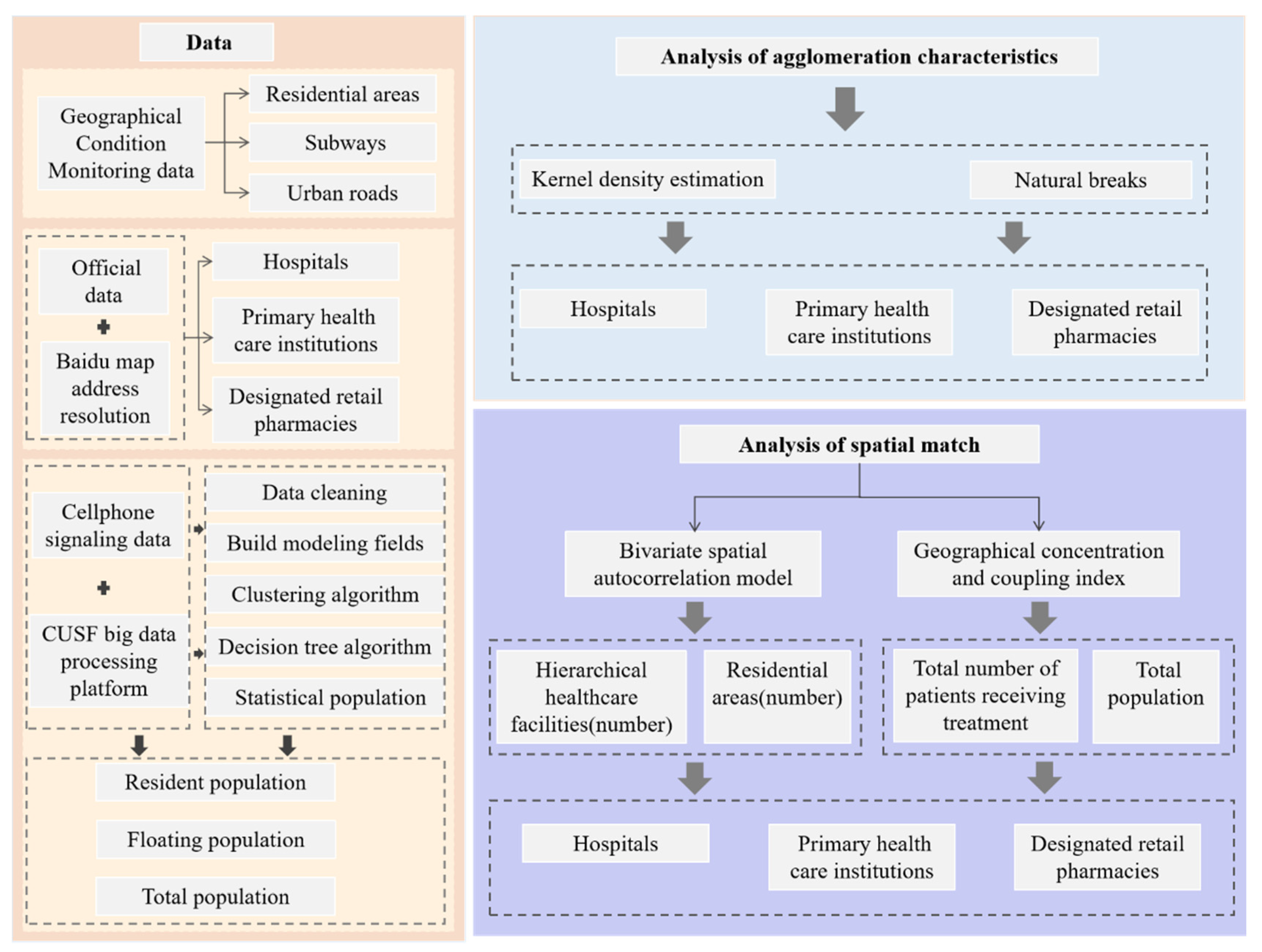
2.1. Methodological Flow
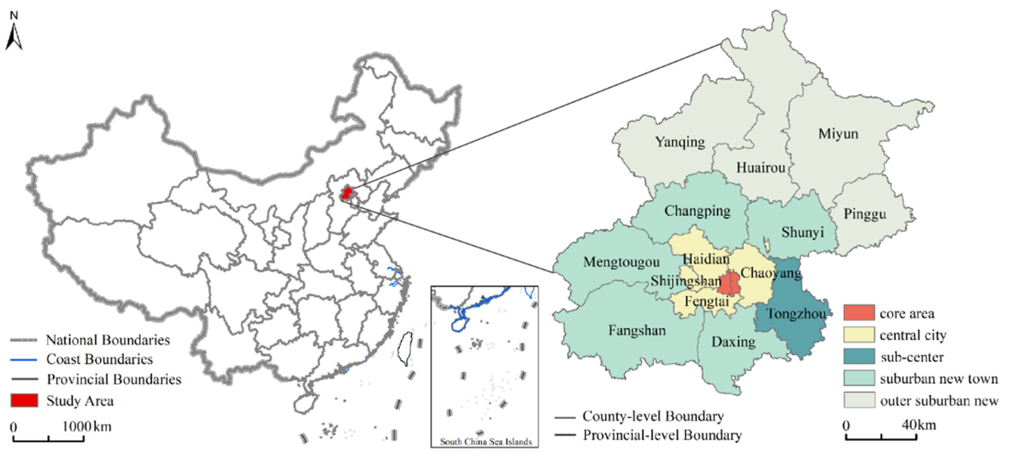
2.2. Study Area
2.3. Data Sources
2.3.1. Geographical Condition Monitoring Data
2.3.2. Official Data
2.3.3. Cellphone Signaling Data
- Data preprocessing. Due to a large amount of data, ordinary software is not competent for processing. Therefore, the China Unicom Smart Footprint (CUSF) big data processing platform is used for saving, reading, and preprocessing the data in our study, which is an advanced big data processing framework based on the Spark cluster of the Hadoop architecture. The noise of the raw signaling data mainly includes the time errors and data that cannot effectively track the International Mobile Subscriber Identity (IMSI) number. The base station parameters are used to clean the noise in the signaling data to obtain the correct signaling generation location [34].
- Population type identification. To identify population types, four steps are set. First, we construct the stay and behavior characteristics in both time the dimension and spatial dimension. In the time dimension, the number of signaling items, stay time, stay days, and stay months of each user in the corresponding scene area is counted. In the spatial dimension, the location of the user is recorded. Secondly, we use two-step and K-means clustering algorithms to cluster the crowds. Thirdly, the decision tree algorithm is used to classify the crowds to the resident population and the floating population. Finally, the resident population and the floating population in the area are counted according to the population identification tags. The algorithm mainly determines where the user resides. There are two core judgment logics: one is that the user has at least two consecutive signaling events in the same base station and its vicinity; the other is the time limit [34,35]. The resident population and floating populations are commonly found in the Chinese census, and the definitions are clear [36]. The floating population is a unique population group in China, which is closely related to the household registration system [37]. However, the definition of population type is disunity in terms of the big data. Wang put forward the definition of actual population, which was defined as the population that has stayed in the urban local space on average every day, and divided it into the static population and floating population [38]. Han and Shi further proposed time thresholds for defining population types [39,40]. Considering Han and Shi’s classification of population types, we define the resident population as appearing in the same position at 21:00–07:00 for over 10 days in November. The floating population is defined as the users staying in the same city for more than 3 h in a day, but the nonresident population of the city. The total population is the sum of the resident population and the floating population.
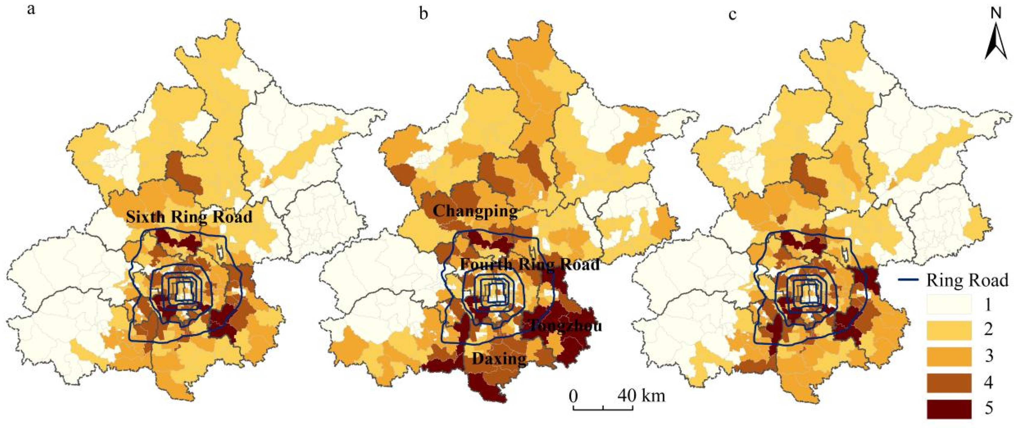
- Population distribution characteristics. We divide the population into five levels, from high to low in 5,4,3,2,1. As Figure 3 shows, the resident population is mainly distributed within the sixth ring road and adjacent streets. The floating population is mainly distributed outside the fourth ring road, especially in Tongzhou, Daxing, and Changping, where there is a large floating population number. The distribution characteristics of the total population are roughly similar to the resident population, but there is also a significant increase in the population of some streets.
2.4. Methods
2.4.1. Kernel Density Estimation
2.4.2. Bivariate Spatial Autocorrelation Model
2.4.3. Geographical Concentration and Coupling Index
3. Results
3.1. Analysis of Agglomeration Characteristics of Hierarchical Healthcare Facilities
3.1.1. Spatial Pattern Analysis of Hospitals
3.1.2. Spatial Pattern Analysis of Primary Healthcare Institutions
3.1.3. Spatial Pattern Analysis of Designated Retail Pharmacies
3.2. Analysis of Spatial Match from Quantity
3.3. Analysis of Spatial Match from Capacity
3.3.1. Spatial Match Analysis of Hospitals
3.3.2. Spatial Match Analysis of Primary Healthcare Institutions
3.3.3. Spatial Match Analysis of Designated Retail Pharmacies
4. Discussion
4.1. Understanding Spatial Match from Quantity and Capacity
4.2. Policy Implications
4.3. Limitations and Prospects
5. Conclusions
Author Contributions
Funding
Institutional Review Board Statement
Informed Consent Statement
Data Availability Statement
Conflicts of Interest
References
- Xie, X.H.; Wang, R.Z.; Wen, D.H.; Zhang, Z.Y. Evaluating the Medical Facilities Layout Based on GIS: An Application of Xiang’an District. J. Geo-Inf. Sci. 2015, 17, 317–328. [Google Scholar]
- Luo, L.; Lou, J.; Tian, L.L.; Liu, P.C.; Zheng, W.S. Spatial location-allocation optimization for rural hospital with an improved regional allocation model: A case study in Xiantao city of Hubei province. Sci. Geogr. Sin. 2016, 36, 530–539. [Google Scholar]
- Liu, Z.; Yang, H.Y.; Xiong, W.C.; Chen, G.H. Spatial accessibilities of medical services at county level based on optimized two-step floating catchment area method. Sci. Geogr. Sin. 2017, 37, 728–737. [Google Scholar]
- Nie, L.F.; Feng, C.C. Research on accessibility of medical treatment based on grading treatment: A case study of Weifang city center area. Acta Sci. Nat. Univ. Pekin. 2020, 56, 307–314. [Google Scholar]
- Zhong, S.Y.; Yang, X.; Chen, R. The accessibility measurement of hierarchy public service facilities based on multi-mode network dataset and the two-step 2SFCA: A case study of Beijing’s medical facilities. Geogr. Res. 2016, 35, 731–744. [Google Scholar]
- Cao, Y.; Zhen, F. Medical facilities service evaluation and planning response, Nanjing. Planners 2018, 34, 93–100. [Google Scholar]
- Si, Z.J.; Yin, Z. Research on the spatial layout of medical facilities in Beijing from the perspective of international comparison. City Plan. Rev. 2020, 44, 47–54. [Google Scholar]
- Liu, J.; Qing, Z. Research of equalizing layout of public service facilities: Take health facilities of central six districts of Beijing for example. Urb. Dev. Stud. 2016, 23, 6–11. [Google Scholar]
- Ma, Q.W.; Li, Y.H.; Deng, J. Spatial layout and functional evaluation of medical facilities: Hong Kong special administrative region. Planners 2016, 32, 104–110. [Google Scholar]
- Gibson, B.A.; Ghosh, D.; Morano, J.P.; Altice, F.L. Accessibility and utilization patterns of a mobile medical clinic among vulnerable populations. Health Place 2014, 28, 153–166. [Google Scholar] [CrossRef] [PubMed] [Green Version]
- Guida, C.; Carpentieri, G. Quality of life in the urban environment and primary health services for the elderly during the COVID-19 pandemic: An application to the city of Milan (Italy). Cities 2021, 110, 103038. [Google Scholar] [CrossRef]
- Wilson, S.E.; Bunko, A.; Johnson, S.; Murray, J.; Wang, Y.; Deeks, S.L. The geographic distribution of un-immunized children in Ontario, Canada: Hotspot detection using Bayesian spatial analysis. Vaccine 2021, 39, 1349–1357. [Google Scholar] [CrossRef]
- Pu, Q.; Yoo, E.; Rothstein, D.H.; Cairo, S.; Malemo, L. Improving the spatial accessibility of healthcare in North Kivu, Democratic Republic of Congo. Appl. Geogr. 2020, 121, 102262. [Google Scholar] [CrossRef]
- Chakrabarti, S.; Tatavarthy, A.D. The geography of medical travel in India: Differences across states, and the urban-rural divide. Appl. Geogr. 2019, 107, 12–25. [Google Scholar] [CrossRef]
- Kanuganti, S.; Sarkar, A.K.; Singh, A.P.; Arkatkar, S.S. Quantification of accessibility to health facilities in rural areas. Case Stud. Transp. Policy 2015, 3, 311–320. [Google Scholar] [CrossRef]
- Agbenyo, F.; Marshall, N.A.; Dongzagla, A. Accessibility mapping of health facilities in rural Ghana. Transp. Health 2017, 6, 73–83. [Google Scholar] [CrossRef]
- Shin, K.; Lee, T. Improving the measurement of the Korean emergency medical System’s spatial accessibility. Appl. Geogr. 2018, 100, 30–38. [Google Scholar] [CrossRef]
- Dolejš, M.; Purchard, J.; Javorčák, A. Generating a spatial coverage plan for the emergency medical service on a regional scale: Empirical versus random forest modelling approach. Transp. Geogr. 2020, 89, 102889. [Google Scholar] [CrossRef]
- Liu, Y.; Cui, N.; Zhang, J. Integrated temporary facility location and casualty allocation planning for post-disaster humanitarian medical service. Transp. Res. Part E Logist. Transp. Rev. 2019, 128, 1–16. [Google Scholar] [CrossRef]
- Mohamadi, A.; Yaghoubi, S. A bi-objective stochastic model for emergency medical services network design with backup services for disasters under disruptions: An earthquake case study. Int. J. Disaster Risk Reduct. 2017, 23, 204–217. [Google Scholar] [CrossRef]
- Herwartz, H.; Schley, K. Improving health care service provision by adapting to regional diversity: An efficiency analysis for the case of Germany. Health Policy 2018, 122, 293–300. [Google Scholar] [CrossRef] [PubMed]
- Bruno, G.; Cavola, M.; Diglio, A.; Piccolo, C. Improving spatial accessibility to regional health systems through facility capacity management. Soc.-Econ. Plan. Sci. 2020, 71, 100881. [Google Scholar] [CrossRef]
- Zhang, Q.; Zhang, J.M. The evolution of thematching on elderly population and healthcare resource space: An empirical analysis based on Shanghai statistical data. Chin. J. Health Policy 2019, 12, 18–23. [Google Scholar]
- Yin, J.; Xu, S.Y.; Jing, Y.M.; Yin, Z.E.; Liao, B.G. Evaluating the impact of fluvial flooding on emergency responses accessibility for a mega-city’s public services: A case study of emergency medical service. Acta Geogr. Sin. 2018, 73, 1737–1747. [Google Scholar]
- Zhang, T.T.; Li, J.M.; Bai, G.; Li, J.; Xiong, X.C. A layout planning methodology of increasing the designated medical insurance drugstores guided by fairness and efficiency. Chin. J. Health Policy 2018, 11, 59–63. [Google Scholar]
- Qi, M.Z.; Dong, Y.F. Analysis on population equity of medical resources allocation among 18 districts and counties in Beijing. Soc. Sci. Beijing 2010, 5, 27–33. [Google Scholar]
- Tao, Y.H.; Shen, Y. Spatial difference of medical facility accessibility and influencing factors: A comparative study of registered and floating populations in Shanghai. Prog. Geogr. 2018, 37, 1075–1085. [Google Scholar]
- Zhang, F.; Hu, L. Research on resilience improvement strategies for medical care and epidemic prevention: A case study of medical facilities in Beijing. City Plan. Rev. 2020, 44, 9–14. [Google Scholar]
- Beijing City Master Plan (2016–2035). Available online: http://ghzrzyw.beijing.gov.cn/zhengwuxinxi/gzdt/sj/201912/t20191223_1421777.html (accessed on 12 November 2021).
- Zhang, J.X.; Li, W.S.; Zhai, L. Understanding geographical conditions monitoring: A perspective from China. Int. J. Digit. Earth 2015, 8, 38–57. [Google Scholar] [CrossRef]
- National Health Service System Planning Outline (2015–2020). Available online: http://www.gov.cn/xinwen/2015-03/30/content_2840331.htm (accessed on 11 October 2021).
- Wang, D.; Li, D.; Fu, Y.Z. Employment space of residential quarters in Shanghai: An exploration based on mobile signaling data. Acta Geogr. Sin. 2020, 75, 1585–1602. [Google Scholar]
- Hai, X.D.; Liu, Y.S.; Zhao, P.J.; Zhang, H. Using mobile phone data to estimate the temporal-spatial distribution and socioeconomic attributes of population inmegacities: A case study of Beijing. Acta Sci. Nat. Univ. Pekin. 2020, 56, 518–530. [Google Scholar]
- Zhou, Y.Y.; Tao, Z.T.; Zhu, X.; Wang, Q.J. Method and Device for Calculating Operator’s Proportion. China Patent CN110312213A, 21 April 2021. [Google Scholar]
- Feng, Y.H.; Zhao, P.J.; Wu, Y.M.; Liang, J.; Zhang, Y. Assessing the impact of function dispersion in big citys on population relocation using mobile phone data: A case study of the zoo wholesale market in Beijing. Urb. Dev. Stud. 2020, 27, 38–44. [Google Scholar]
- Duan, C.R.; Sun, Y.Q. Historical changes in statistics of floating population in China. Popul. Res. 2006, 30, 70–76. [Google Scholar]
- Zhang, Z.X.; Yang, S.S. A Review on the concepts, data and fields of floating population research. Chin. J. Popul. Sci. 2013, 6, 102–112. [Google Scholar]
- Wang, D.; Ren, X.Y. Distribution and composition of actual population in urban space from daily human mobility view. Urb. Plan. Forum 2019, 2, 36–43. [Google Scholar]
- Han, B.L.; Ren, X.Y.; Wang, D. Research on the localized population dynamics in Beijing based on cell phone data: Distribution, mobility, and temporal variation. J. Human Settl. West China 2021, 36, 104–112. [Google Scholar]
- Shi, C.; Tian, L.; Cheng, Y. Regional spatial organization from the perspective of short-term travel: An empirical study on the Yangtze River Delta based on mobile phone data. Urb. Rural Plan. 2020, 6, 105–115. [Google Scholar]
- Zhan, D.S.; Zhang, W.Z.; Zhang, J.F.; Li, J.M.; Dang, Y.X. Identifying urban public service facilities centers in Beijing. Geogr. Res. 2020, 39, 554–569. [Google Scholar]
- Gatrell, A.C.; Bailey, T.C. Interactive spatial data analysis in medical geography. Soc. Sci. Med. 1996, 42, 843–855. [Google Scholar] [CrossRef]
- Schabenberger, O.; Gotway, C.A. Statistical Methods for Spatial Data Analysis; CRC Press: Boca Raton, FL, USA, 2005. [Google Scholar]
- Zhao, P.J.; Luo, J.; Hu, H.Y. Spatial match between residents’ daily life circle and public service facilities using big data analytics: A case of Beijing. Prog. Geogr. 2021, 40, 541–553. [Google Scholar] [CrossRef]
- Chen, W.; Zeng, J.; Li, N. Change in land-use structure due to urbanisation in China. J. Clean. Prod. 2021, 321, 128986. [Google Scholar] [CrossRef]
- Anselin, L.; Syabri, I.; Smirnov, O. Visualizing Multivariate Spatial Correlation with Dynamically Linked Windows; University of California Santa Barbara Cd Rom: Santa Barbara, CA, USA, 2002. [Google Scholar]
- Ellision, G.; Glaeser, E.L. Geographic concentration in U. S. Manufacturing industries: A dartboard approach. J. Urb. Econ. 2000, 9, 48–67. [Google Scholar]
- Zhang, D.; Cao, W.D.; Zhu, S.Q. Study on spatio-temporal coupling of logistic and economy in Anhui Province. Areal Res. Dev. 2014, 33, 27–32. [Google Scholar]
- Xu, S.N. Imbalanced distribution characteristics of population-economy in Henan. Areal Res. Dev. 2014, 33, 155–159. [Google Scholar]
- Guan, D.J.; Tian, J.; Zhang, M.J.; Lan, Z.Z.; Su, W.C. Spatial coupling distribution of population and economic development in Chongqing. Human Geogr. 2017, 32, 122–128. [Google Scholar]
- Zhao, S.R.; Li, N.; Liu, Y.L. Research on spatial distribution rationality of medical resources in Beijing. Contemp. Med. 2018, 24, 22–25. [Google Scholar]
- Wu, X.Y.; Hu, Y.H.; Li, D.H.; Zhu, X.M.; Li, J.Y. Study on the allocation equity of medical insurance designated retail pharmacies in Shenzhen. Chin. J. Health Policy 2021, 14, 28–34. [Google Scholar]
- Fan, L.H.; Lin, X.Q.; Wang, D. Spatial-temporal succession characteristics of public service facilities supply and demand coordinated development in Beijing: A case study of education and medical facilities. Human Geogr. 2015, 30, 90–97. [Google Scholar]
- Wang, S.P.; Huang, E.D. Analysis on the allocation equality in health resources in Beijing based on Theil Index and agglomeration degree. Chin. Health Econ. 2020, 39, 44–48. [Google Scholar]

| Data Category | Serial | Category Name | Amount |
|---|---|---|---|
| Hospitals | H1 | General hospitals | 724 |
| H2 | TCM hospitals | ||
| H3 | Combined traditional and western medicine hospitals | ||
| H4 | National hospitals | ||
| H5 | Specialized hospitals | ||
| H6 | Nursing homes | ||
| Primary healthcare institutions | P1 | Community health service centers | 8509 |
| P2 | Community health service stations | ||
| P3 | Health centers | ||
| P4 | Outpatient departments and clinics | ||
| Designated retail pharmacies | D1 | - | 773 |
| Healthcare Facility Level | Annual Average Number of Patients Receiving Treatment (Ten Thousand People) |
|---|---|
| Tertiary hospitals | 108.98 1 |
| Secondary hospitals | 19.64 |
| Primary hospitals | 3.65 |
| Not evaluated | 1.66 |
| Community health service center(station) | 3.29 |
| Outpatient departments | 0.52 |
| Clinics | 0.18 |
| Health centers | 0.09 |
| Designated retail pharmacies | - |
| Category | Hospitals | Primary Healthcare Institutions | Designated Retail Pharmacies |
|---|---|---|---|
| Moran′s I | 0.75 | 0.68 | 0.64 |
| p-value | 0.001 | 0.001 | 0.001 |
| Z-value | 425.76 | 396.40 | 388.80 |
Publisher’s Note: MDPI stays neutral with regard to jurisdictional claims in published maps and institutional affiliations. |
© 2022 by the authors. Licensee MDPI, Basel, Switzerland. This article is an open access article distributed under the terms and conditions of the Creative Commons Attribution (CC BY) license (https://creativecommons.org/licenses/by/4.0/).
Share and Cite
Cai, X.; Wang, H.; Ning, X.; Du, Q.; Jia, P. Multidimensional Spatial Match of Hierarchical Healthcare Facilities Considering Floating Population: A Case of Beijing, China. Sustainability 2022, 14, 1092. https://doi.org/10.3390/su14031092
Cai X, Wang H, Ning X, Du Q, Jia P. Multidimensional Spatial Match of Hierarchical Healthcare Facilities Considering Floating Population: A Case of Beijing, China. Sustainability. 2022; 14(3):1092. https://doi.org/10.3390/su14031092
Chicago/Turabian StyleCai, Xingfei, Hao Wang, Xiaogang Ning, Qiyong Du, and Peng Jia. 2022. "Multidimensional Spatial Match of Hierarchical Healthcare Facilities Considering Floating Population: A Case of Beijing, China" Sustainability 14, no. 3: 1092. https://doi.org/10.3390/su14031092
APA StyleCai, X., Wang, H., Ning, X., Du, Q., & Jia, P. (2022). Multidimensional Spatial Match of Hierarchical Healthcare Facilities Considering Floating Population: A Case of Beijing, China. Sustainability, 14(3), 1092. https://doi.org/10.3390/su14031092


