1. Introduction
The pandemic has exposed the structural and systemic inconsistencies in our model of development, exacerbating spatial and environmental injustices in cities, the beating heart of contemporary societies [
1,
2,
3,
4]. It is therefore no coincidence that it is cities which have provided the first responses to the COVID-19 pandemic. Pioneering cities include those in the ‘C40’ group, a global network of cities working to reduce environmental and social risks caused by climate change, whose political agenda for recovery covers specific measures to regain a ‘new normal’. The goal of these cities is to prepare themselves to contain future pandemics, address systemic injustices, and keep global warming below the 1.5 °C target [
5]. This network of cities has taken the ‘15-min city’ as a model for post-COVID recovery, a model of urban development based on the principle that all services are available to citizens within a maximum distance of 15–20 min. In this way, people do not have to use cars or public transport, thereby reducing traffic and pollution, recovering the time lost due to travel and rediscovering sociality.
This model, originally tested in Portland with its ‘20-Minute Neighborhoods’ policy [
6] and Melbourne with its ‘20-Minute Neighbourhood Pilot Program’ [
7], was launched in Europe in Paris as part of Mayor Hidalgo’s election platform and from there, it has been adopted by many other European cities. In addition to focusing on ecology, solidarity, and participation, the type of 15-min city emerging from the experience in Paris is the ‘city of proximity’.
This example, which actually forms the basis for those in Portland and Melbourne, is not a new concept in urban planning. It was originally associated with the ‘neighbourhood unit’, introduced as early as 1929 in studies for the New York Regional Plan by Clarence Perry. This served as a playing field in the debate on reconstruction after the Second World War (from Patrick Abercrombie’s Greater London Plan to the New Towns). It crossed the debate on European public neighbourhoods, including Italian experiments with the INA-Casa plan, and then the debate on suburban council housing up to the 1970s. Since the 1980s, this topic has all but disappeared from the urban planning debate, since the dynamics of globalization and metropolitan expansion have marked a change in scale of economic processes and the physical attributes of settlements, with the resulting spatial dispersion and multiplication of populations, relationships, services, and functions [
8,
9]. The space of places has been emptied in favour of the space of flows [
10]. Reappearing in Europe starting with the vast Urban programme (Urban I, 1994–1999; Urban II, 2000–2006) [
11] targeting the regeneration of neighbourhoods in crisis, the issue of urban proximity has garnered renewed interest in recent years regarding aspects of people’s daily lives and the organization of supporting functions, services, and resources. Thus, the appropriation of material and immaterial resources (goods, services, relationships) by individuals and social groups was identified as a possible condition for experimenting with innovative strategies for combining work, care, leisure, and socialization [
12,
13].
A dividing line has been drawn between neighbourhoods where the process of appropriation is more difficult due to isolation, mono-functionality [
14], and size, which may therefore constitute an element of structural disadvantage [
15], and neighbourhoods where it is instead easier to access the resources necessary for social reproduction and the construction of life opportunities [
16]. The neighbourhood scale has been associated with reducing the distance in space and time of a wide range of services such as health facilities, nursery schools, social services, commercial services, recreational, cultural, and entertainment facilities, parks, and nature [
17].
Neighbourhood regeneration has been attributed with remedying the uncontrolled expansion of the car-dominated city [
18] and increasing sustainability, resilience to climate change, and health in the urban environment [
19]. This model of proximity, which is at once functional, relational, hybrid, and diverse, makes it possible to find what is needed to live sustainably and responds to the demands and desires of everyday life [
20]. Achieving this mix of values and performance, however, is not always easy.
1.1. The ‘Relational’ Aspect of the City of Proximity
There are undoubtedly parts of the city that have conditions more favourable than others to implement the model of the city of proximity. It is no coincidence that the images of Paris in ‘Dossier de Presse-Le Paris du Quart d’heure’ (2020) refer to the compact city as an ideal model in which the principles of proximity are made explicit. The question arises as to whether the model of the 15-min city can be reproduced in suburban neighbourhoods around modern cities created for speed, where the lack of proximity is not necessarily (only) functional. In the creation of an increasingly polycentric city, with perfectly independent neighbourhoods complete with every function and service like those being planned in Paris and Milan and other cities around the world, the challenges concern not only accessibility to services, which must always and nevertheless be guaranteed, but also the liveliness of the relationships that arise in places. Relational proximity seems to be lacking, for example, in French ‘priority neighbourhoods’, where a 2019 survey revealed better pedestrian access to public facilities and services in less than 15 min compared to other neighbourhoods. However, the negative opinion expressed by residents concerns a very degraded living environment [
21], speaking volumes about the limits of so-called theoretical proximity and the existence of ‘physical brakes’ related to the isolation of the neighbourhood, the lack of continuity and legibility of pedestrian routes, the large space provided for cars in public space, etc. [
22]. Therefore, the city of Paris, with its ‘Appel a projets politique de la ville-2021’, has set the objective of turning the collective spaces of these neighbourhoods into common spaces to strengthen the social ties that are currently lacking.
The issue that arises today may therefore not entail the simple or exclusive search for functional proximity, but the reconfiguration and re-use of spaces in the name of better quality (as defined by Richard Sennet in ‘Building and Dwelling: Ethics for the City’) means that there are more opportunities for the community to meet [
23] to develop the social interactions that constitute the very essence of the city [
24,
25,
26].
In this context, urban planning and design is asked to play an important role to make places work as connectors of sociality rather than separation [
14]. Of course, this should not lead to sheltering in spatial determinism [
27] but rather the recognition that with its physical conformation and symbolic elements, space tends to orient people’s interactions. In this regard, Jan Gehl argues in ‘Cities for People’ that it is certainly not empty boulevards or a neighbourhood of detached houses and blocks that affect people’s quality of life but rather the diversity and density of relationships that can be established in places [
28]. Looking at Italian suburbs and council housing districts in particular, the presence of many unfinished parts—especially the design and use of open spaces and collective facilities—undermines the social quality of these parts of the city [
29]. The space and public services, even when they are present after initial deficiencies, are the result of spaces whose configuration is often the basic two-dimensional representation of the urban-planning standards established by Ministerial Decree 1444/68. These consist of building/urban-planning parameters and indexes that were long considered only in quantitative terms (minimum floor area for public services). They relied on design criteria that were often rigid and pre-established, conceived without creating a relationship with the unique aspects of the context, almost as if it were enough to fill ‘empty’, degraded spaces to give new meaning to city sectors that had lost the representative patina of time [
30].
1.2. The Thesis of the CCHURE Research Project
This article considers these models and design criteria, which are often confirmed in Italian suburbs and beyond, falling in line with Pozoukidou and Chatziyiannaki [
31]. It presents the idea that in the post-COVID city, the issue of proximity, understood as functional and relational proximity [
20] and implemented based on the required inclusion, safety, and health, can play a fundamental role in both the project definition of living spaces and reinforcement of the ‘strong ties’ underlying empowerment of the local community [
32]. This thesis is supported by the ‘CCHURE–Climate Change & Urban Resilience’ research project, which uses the identifying features of the Italian council housing suburbs built after the Second World War to investigate, evaluate, and design the working-class neighbourhood of Monticelli in Ascoli Piceno (Central Italy). Here, the proposal for the rebirth of physical space and adaptation to climate change works by strengthening the ties of proximity in the name of inclusion, safety, and health. For this research, which began in 2019 before the COVID-19 pandemic, a large part of its cognitive, assessment, and design investigations on the neighbourhood scale were developed during the full Italian lockdown (March–June 2020), dealing with the needs, requirements, and expectations of the local community. Based on the experience of places and new needs emerging during the pandemic, these contributed to formulating a proposal for urban regeneration marked by relational proximity.
The proposal for regeneration addressed daily physical movements and the abundant yet little-used open spaces in the neighbourhood, with the aim of improving safety, attractiveness, and environmental comfort. These requirements, called for in the urban planning project through a co-design process with the local community, have proved useful for ‘bringing together’ places and people, that is, achieving the relational proximity that is lacking in this neighbourhood despite its functional proximity.
This article is organized into three parts. In the first part (research framework), an excursus is made regarding the characteristics of Italian council housing neighbourhoods and opportunities for regeneration following the change in perspective caused by the pandemic and affirmation of the principles of the so-called 15-min city, with a focus on new opportunities for health, adaptation to climate change, and sociality tied to open spaces and street space. In the second part (materials and methods), the article presents the working method applied to an Italian council housing district, the Monticelli neighbourhood of Ascoli Piceno, Italy, where regeneration of the district is conceived through reinforcement of the bonds of proximity, working on the issues of inclusion, safety, and health and securing the public space with regard to the risks of climate change. The third part (results and conclusions) presents the intermediate results of the research on the Monticelli neighbourhood and presents some avenues for further research.
2. Research Framework
Amid the world crisis triggered by COVID-19, Italy was the first European country to be hit, with the first ‘red zone’ instituted outside of China in the area of Codogno, Italy, and nine other municipalities on 21 February 2020. The lockdown was then gradually extended, until it reached the entire country on 11 March. During the peak of the emergency, cities served as the ideal place for translating national or regional regulations and guidelines on the local level and guaranteeing their implementation.
In stripping cities of their daily life, the pandemic highlighted the need to access a safe, convenient, and sustainable transport system, inclusive urbanization, planning and managing a participatory and integrated human settlement, and reducing environmental impacts with attention to air quality, urban waste management, and access to safe green and public spaces. With the pandemic, these needs could no longer be deferred. Cities such as Milan, Bologna, Modena, etc. had to accelerate the process of urban regeneration that had already begun before the pandemic, starting with the activation of projects designed to improve the quality of life of public space and neighbourhood life. Creating new neighbourhood squares and services, encouraging means of sustainable movement, and guaranteeing space for children to play were, for example, objectives already set out in urban plans in Milan, in Bologna as adopted in December 2020 and in Modena and many other cities.
The need to change city rhythms in the search for a ‘new normal’ served as an incentive to accelerate the achievement of these objectives, even identifying temporary, less expensive, and more efficient solutions. In these cities, the neighbourhood scale has become the natural area of reference for policies and project tests, with priority for council housing neighbourhoods as established, for example, by the ‘Programma Innovativo Nazionale per la Qualità dell’Abitare’ (PinQua) (Innovative National Programme for Housing Quality). This initiative finances proposals for urban regeneration to be realized without new land consumption by improving accessibility and safety, environmental quality, the use of innovative models, and tools for urban management, inclusion, and well-being. Faced with this choice, which seems to confirm the centrality of council housing neighbourhoods in the debate on Italian cities following the COVID-19 crisis, it is necessary to question whether these neighbourhoods are capable of responding to the new challenges in the contemporary city and the search for proximity. The following sections summarize the characteristics of public council housing neighbourhoods in Italy and the new attention for the city of proximity, which constitutes a possible response for cities to the COVID-19 pandemic.
2.1. Council Housing Neighbourhoods in the Post-COVID City: Italy
In Italy, we can summarily identify three periods over the last seventy years that mark the construction of the public city: the INA-Casa Plan (1949–1963), the Council Housing Plan (
Piano di Edilizia Economica e Popolare, PEEP), which ran from 1962 to 1977, and the second PEEP, which ran from 1978 to 1992. Below, a short historical excursus presents the salient phases in constructing the public city in Italy following the Second World War.
Figure 1,
Figure 2 and
Figure 3, which refer to three neighbourhoods in the city of Rome, are used as examples to represent the models (each neighbourhood represents one) that developed in all of Italy through similarity, both in large cities and in small to medium-sized ones.
On 24 February 1949, almost four years after the liberation from fascism, the Italian government passed Law no. 43, Provvedimenti per incrementare l’occupazione operaia. Case per lavoratori (Provisions to increase worker employment. Worker housing). This was the start of the so-called INA-Casa Plan, the largest public housing programme that Italy had ever developed. First and foremost, the project had to respond to growing unemployment, a fact which must not be forgotten. The plan, later called the ‘Fanfani Plan’ after the minister who proposed it, lasted fourteen years, divided into two seven-year periods. This plan accompanied a significant phase in Italian political and economic life and, from an urban and architectural point of view, represented one of the most important phases in the realization and experimentation of new social housing.
Neighbourhoods built under this plan provided an opportunity to improve the housing and living conditions of thousands of families. For the young architects, urban planners, and engineers involved in the project, it was a great opportunity to experiment with architecture and urban planning to give a form and substance to post-war reconstruction. The new neighbourhoods attempted to define the ideas and theories of the city developed along the research paths that urban planning had followed on its way towards modernity to offer spaces to communities of citizens and represent a new society in the making [
33]. These were ‘small’ interventions whose merit lay in their presentation as neighbourhoods, with the provision of services and collective facilities as a sign of individual–collective coexistence, translated into a recognizable arrangement and organization of built and open spaces.
Neighbourhoods in this experience were thought of as self-sufficient, well-defined organisms based on neighbourhood unity and the concept of proximity of a small community. Configured over time, public space and open space defined the urban layout that oscillates today between neo-organic references and rationalist meshes of Northern European extraction. Today, the richness of the connecting space is expressed in greenery among blocks of flats, in the detachment between buildings and their position, orientation/exposure, in the pedestrian and vehicular space, or in the roadway network that becomes the ordering element in a defined and completed urban mesh [
34] (
Figure 1). The two seven-year periods of the INA-Casa Plan were followed by the two longer periods of the Council Housing Plan pursuant to Law 167/62. This law was meant to encourage the acquisition of land for low-cost and social housing, and its main purpose was to end the location practice followed up to then for such housing by the municipalities and myriad entities that had gradually benefited from low-cost housing measures [
35]. These entities had scattered social housing estates in areas far from the city, sold at a low cost in order to develop the surrounding land, causing devastating effects on the urban layout and also helping to jeopardize the provisions of regulatory plans.
The law prescribed and definitively clarified that the areas must fall within the expansion areas provided for by urban-planning tools. It also marked the transition from social housing intended as welfare for the most vulnerable groups to council housing [
36]. The small size of the INA-Casa neighbourhood in the PEEPs gave way to a larger scale of intervention. In large cities, these neighbourhoods sometimes had the size of real towns, although without their own form, content, or relationships. Urban and architectural experimentation with open systems was seen, with a free arrangement of the buildings with respect to the plots and the separation of vehicle and pedestrian routes, giving rise to completely new forms in terms of the scale of intervention, overall layout, the relationship between buildings and open space, and discontinuity between types of fabric.
The results of this design immediately highlighted significant criticalities: building and social decay, open areas designated as public green spaces that soon became abandoned and unsafe, and parking spaces serving a car-dominated infrastructure that connects but separates and does not relate (
Figure 2). Faced with these urban-planning considerations, the production of larger and (sometimes) good-quality housing should not be forgotten, which provided the opportunity to experiment with new forms and construction techniques.
This occurred mainly in the first PEEP, while an attempt was made in the second one to correct previous mistakes. This marked a return to a more measured, contained layout and a more controllable scale of intervention that reproduced a fabric characterized by an urban weave, with its spatial and relational hierarchies, a rediscovered organization, and aggregation of types of building units that apparently restored a recognizable compositional scale. Nevertheless, not even this experience managed to relate to its surroundings. On the contrary, it seemed to propose finished, defined pieces of fabric, complete with services and commercial facilities but which were not capable of establishing relations with the surrounding fabric, re-establishing neighbourhood and proximity relationships, or mending the urban fabric as was said in the 1980s (
Figure 3).
Overall, the experience of the PEEPs shows a panorama where the common denominator seems to be the incompleteness of the system, especially due to the lack of services and the space that should have represented the urban and social glue. Over time, this void has become ‘available space’, unfinished and often degraded. Today, these parts of the city, if investigated with respect to their ‘city form’, offer a sample of spaces to reflect on for redesigning in a sustainable, qualitative way: completed fabrics and open forms, green spaces, public spaces, meeting places, streets, and paths that the private city does not often guarantee except in contexts of economic and social exclusiveness.
In light of current transformations and especially with respect to how these neighbourhoods have arrived to the present day in a more or less consolidated form, a thought must also be spared for the criteria of urban regeneration. These fabrics now feature a historicized structure, the expression of a theoretical thought and technical-design practice peculiar to the second half of the twentieth century. The question therefore also arises as to how to combine the historical heritage of urban planning and architecture—recognized by its form, structure, and building types—with the demand for an urban transformation full of relationships. In this sense, it encourages reflection on the quantitative and qualitative nature of open space and the degree of incompleteness of the fabric, which has always been considered an element of degradation and is now seen as potential for adapting and transforming the urban layout, where fluid and continuous relational densities can be introduced and tested.
Transforming these spaces into ‘habitable spaces’ in the name of proximity constitutes a challenge for the post-COVID city. Faced with European experiences that depict a complex panorama, where ‘the neighbourhood’ is at the centre of strategies, actions, and interventions that completely rethink public space starting from social-climate-health criteria [
37], the question arises as to what role council housing neighbourhoods can play as a potential ‘urban design unit’, thereby verifying the performance of their original urban layout and the ways to transform open space as a function of adaptation to climate change. At the same time, critical reflection should be based on the value and design criteria of the original systems in light of the requirement for inclusion, safety, and health, which play a fundamental role in affirming the principles of proximity, understood as diversity and relationship density. In this perspective, public and semi-public open space and streets play a decisive role in reinterpreting the design of the urban layout with a view to regeneration that responds to new relationships between space, time, and functions.
2.2. A New Look at the Open Public/Semi-Public Space and the Street
During the pandemic, social distancing constraints brought to attention the interplay between urban design and rules, between structure and urban life, and how city dwellers respond to these constraints, turning them into opportunities [
38]. The lockdown introduced completely new ways of looking at open spaces. In the first weeks of the pandemic, many cities closed parks and green spaces in an attempt to curb the spread of the new virus. Political leaders and public health experts then realized that the outdoors was actually one of the safest places to be. Cities opened parks and closed roads; they repurposed pavements and car parks for safer public dining and they added improvised bike lanes and widened pavements to create more physical space for pedestrians and cyclists. City dwellers thus rediscovered their ties with places and favoured the emergence of collective forms of involvement, often shared on social media and sometimes involving unconventional places such as so-called third spaces: courtyards, balconies, community gardens, etc. [
39,
40,
41].
The potential of these unconventional places to reshape urban design may serve as an opportunity. The same is true of temporary transformations of streets and other short-term measures that could eventually become permanent [
42] based on citizen responses. This is an experiment based on trial and error, which may accelerate the way in which we plan and transform our cities. The pandemic has also highlighted the role of green spaces in fostering social relationships and mitigating the negative effects of urban living on physical and mental health [
43,
44,
45,
46,
47]. Furthermore, it has highlighted the links with climate-change adaptation measures, for example, with regard to the heat island, air pollution [
48], and measures to mitigate effects on green areas.
A city for people rather than for cars has come to the fore in public opinion. Growing research and projects have begun to investigate the factors that shape relationships between individuals and urban space via the street. These have focused on four main aspects that serve as key determinants of so-called walkability: attractiveness, comfort, safety, and ease of walking or cycling [
49], without forgetting the positive effects on the reduction of air pollution and the well-being and health of inhabitants.
Regarding the first requirement, attractiveness, Steve Mouzon uses the term ‘walk appeal’ [
50] to highlight that people will walk a distance even greater than the so-called walking tolerance (1/4 mile for Americans) and will enjoy that walk more if the quality of the urban environment is favourable. This means that there are measurable incentives to walk along the route, such as the percentage of a building’s façade composed of windows, the presence of destinations and landmarks, commercial activities, etc. Conversely, if a roadway environment is hostile to pedestrians because it was built for cars (i.e., a lack of pavements, enormous car parks to cross, etc.), people will be less likely to want to walk more than a short distance.
Comfort is the second requirement. This covers a wide range of urban design factors that make walking trips enjoyable, such as protection from the weather [
51,
52], the aesthetic potential of vegetation, and the perception of biodiversity [
53].
The third requirement is safety, in the form of urban design factors that evoke a feeling of safety, such as lighting, safe crossing design, etc. [
54]. Finally, the need to facilitate walking refers to urban factors deriving from street design in terms of access to destinations, such as distance to major places, pavement type and width, a networked pedestrian infrastructure, etc. [
55,
56]. In many studies, walkability is presented as an important factor for people’s well-being and health, for its ability to weave relationships with other neighbourhood inhabitants and with places, assuming important and different meanings and aspects for children, adults, and elderly people [
57]. Other studies have focused on pedestrians’ ability to interact with retail activities and cultural events along pedestrian routes [
58].
In view of this change in perspective, it should be understood how council housing neighbourhoods, and Italian working-class neighbourhoods in particular, can start working again on open space, green spaces, and streets. There are innumerable degraded and unmanageable public spaces to deal with, along with urban standards, even where established, which have either not been realized or lack quality and equipment. This is not just a matter of fighting land waste under the principles of environmental sustainability, but of mending the shreds of a torn and extremely degraded public space that leads to the development of fear and consequent physical abandonment, triggering a cycle of social decline. These spaces are likely to receive renewed attention as outdoor refuges for stress relief, recreation, cultural activities, and social connection.
2.3. A Case Study: The Monticelli Quarter in Ascoli Piceno
The CCHURE research project dealt with a neighbourhood inserted in the second phase of construction of the public Italian public city in reference to the 1962–1977 PEEP period, as described above.
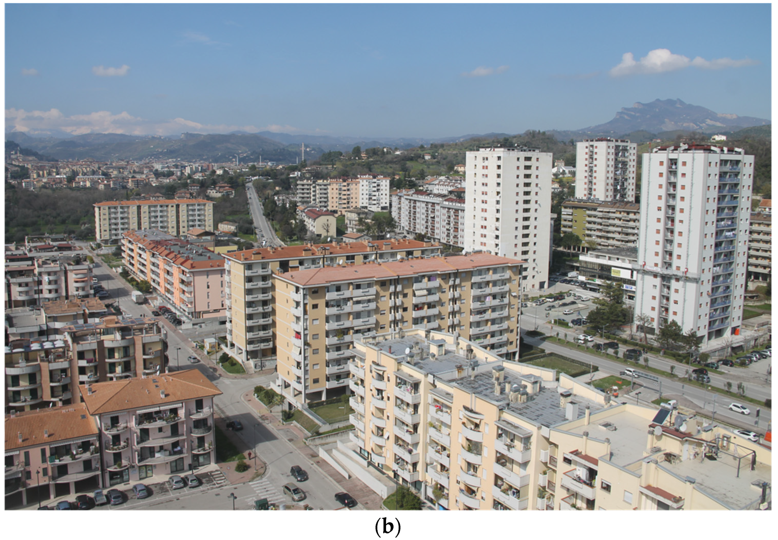
Monticelli is a district in the city of Ascoli Piceno, Italy. It stretches two kilometres along a Roman road, the Via Salaria, which connects Rome to the Adriatic Sea. Its creation is tied to a desire that developed in the 1950s to govern expansion outside the historical centre in an area that was not urbanized at the time, in relation to the planned industrial development of the Tronto Valley, the largest urban centre of which is the city of Ascoli [
59]. In the modification to the Regulatory Plan of Ascoli Piceno (1963–72), Leonardo Benevolo, one of the most emblematic figures in Italian architecture and urban planning, envisioned a city that developed linearly along the west-east axis. Up to the 1970s, Monticelli was an agricultural area. After the earthquake in 1972, however, some ‘emergency’ buildings started to rise here, including two skyscrapers in the eastern part to house those evacuated from the historical centre. In the span of just a few years, consistent urbanization consolidated around these two modern towers. Benevolo had identified a hierarchy of areas dedicated to different functions. These were served by an infrastructure system based on different levels of use: roads for quick decentralized passage (towards the bank of the Tronto River), central roads for internal mobility, and secondary roads orthogonal to the central axis (
Figure 4a,b).
In the northern zone, pedestrian paths were planned (in the east and west) with green spaces and other neighbourhood services. Over the years, a long, complex phase of implementing the plan, mainly with council housing, carried the neighbourhood towards widespread degradation (building degradation, a difficult mobility system, scarcity of equipped green spaces, insufficient social centres for gathering and public/private services, little social cohesion, an incomplete urban layout). With regard to infrastructure, the interventions were oriented at creating a series of point-like interventions, including new roundabouts and small yet widespread maintenance projects. The state of degradation has been placed under observation by the city administration in recent decades. In 2001, the city presented a proposal to develop an ‘innovative programme of urban regeneration’ (Ministry of Infrastructure and Transport Decree of 27 December 2001, no. 2522). In 2016, Monticelli obtained substantial funding of €18,000,000 within the framework of Urban Regeneration Projects for Italian Suburbs (Law 208/2015). The proposed programme consists of an integrated set of interventions including initiatives for sustainable mobility, actions to improve residents’ social and economic conditions, and projects to improve the urban décor and environmental conditions of the quarter. To date, however, few of these projects have been realized.
Monticelli has about 7500 residents today, compared to the 21,000 envisioned by Benevolo, and it is considered by many to be a dormitory district. It is configured as a settlement in and of itself with respect to the city of Ascoli Piceno, in which the main road, secondary streets, open spaces or ‘clearings’, and bike paths within the built area do not delimit or identify the places of living; they do not constitute intervals, pauses between the relationships and components of the urban space. They are testament only to the fracture of physical and spatial relationships in the city, which in turn reduces the ties needed to connect people with the places due to the quick speeds along the main axis of the quarter, the Via Salaria, which cuts communication between the places and the subjects passing through. This prevents the urban fabric and its relationships with the context from being read clearly, a context that shows cases of degradation, abandonment, separation, and social isolation. All this denotes a feeling of insecurity in the community, which frequents only some gathering places.
3. Materials and Methods
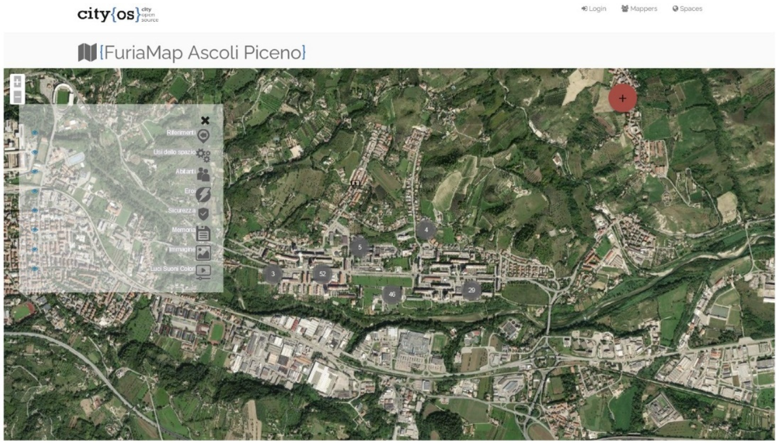
The research on Monticelli began in 2019 and was carried forward during the Italian lockdown in response to a call for financing from the University of Camerino. It was preceded by a ‘collaborative mapping platform’ experiment called ‘Furia Map’, which began in 2015 within the Urban Design Laboratory in the School of Architecture and Design at the University of Camerino (
Figure 5).
This work tested an open-source urban-planning project with the contribution of residents. About 40 students were divided into 8 groups pertaining to the 8 topics of investigation they had selected: uses of spaces, landmarks, heroes, citizen, memory, image, safety, lights-sounds, colours. They collected interviews, videos, and photos and created an animated map, accessible at Cityopensource.net. This neighbourhood map is used to visualize the distribution of services and facilities, recording and updating the transformations taking place and the everyday nature of the change, enabling a continuously updated reading of the city. The results of this experimentation brought to light problems of management, connection, and continuity of the open spaces and residents’ perception of them. Critical issues in the neighbourhood were highlighted, later serving as the starting point for new research on urban regeneration. The results of this initial experiment became the starting point for the ‘Climate Change & Urban resilience’ (CCHURE) university research project.
3.1. Working Method
CCHURE was created as a transdisciplinary project among researchers at the University of Camerino and other Italian and foreign universities. The goal is to define a working method to regenerate public spaces in a council housing district, improving its capacity to positively influence personal health and quality of life and adapting it to the impacts of climate change.
The method regarded:
Assessment of relationships between the impacts of climate change and the health/well-being of residents on the neighbourhood scale, which contributes to selecting actions and combinations of actions for mitigation and adaptation;
Building the conditions for this method to be of use to public administrations when selecting scenarios to adapt to/mitigate the effects of climate change on urban spaces up to 2050, shared with the local population.
Over the course of the research—which began in 2019 and ended in June 2021 and is currently in the conclusive phase—the partial results and onset of the pandemic prompted the design team to focus on the synergistic links between inclusion, safety, and health. Although already present in preliminary analyses and assessments, these aspects oriented the design team in the phase of research conducted during the lockdown even more towards the evaluation and selection of design scenarios aimed at building a city of proximity. The outcome of the research is a sort of test as to how the issues of inclusiveness, health, and safety can constitute necessary services in a city of proximity with a view to climate change adaptation. The working method refers to different areas of investigation, evaluation, and design that were grouped as follows: (a) urban-planning investigation; (b) construction of the neighbourhood health and well-being profile; (c) construction of the climate profile; (d) participatory process with citizens: focus groups; (e) climate and health actions; (f) concept design and identification of pilot projects; and (g) assessment and selection of pilot projects.
3.1.1. Urban-Planning Investigation
This area concerned the recognition of urban, environmental, demographic, and social aspects on the neighbourhood scale, using a GIS environment to construct summary maps of the main features of the neighbourhood in relation to: demographic structure (gender, age groups, presence of foreigners); the population distribution in different areas; the classification of existing green areas and amount of green area per inhabitant; accessibility and the level of safety guaranteed by lighting (direct and indirect); features and performance of the built environment (building types, services, and public facilities); and mobility (parking areas, subways, pavements, cycle paths, pedestrian routes, traffic levels, public transport lines). Other aspects of interest included ongoing projects led by the city administration (projects and plans) and accessibility to public services and facilities within 10 min (800 m on foot): neighbourhood shops, other businesses, supermarkets, playgrounds, sports facilities, religious buildings, public transport stops, and health facilities. The scope of this preliminary analysis was to understand the level of satisfaction in the neighbourhood with regard to daily needs and the presence of areas and sub-areas that are not homogeneous in guaranteeing these basic services.
In detail, the investigations and results as reported in Results are:
Demographic aspects as of 2019 (differentiating the population by gender, age, nationality);
Green areas and public spaces:
A map of green areas and public gathering spaces and type of areas revealed (public green areas, private green areas, green sports areas, playgrounds, river park, agricultural areas, residual and abandoned green areas); squares and gathering places;
Maps of green areas per number of residents, accessibility and usability (land area of the different types of green areas/resident; accessible and inaccessible green areas; illuminated green areas, green areas with indirect lighting, unlit green areas);
Map of planned, equipped, and unequipped green areas.
As a result of the COVID-19 pandemic, the investigation was extended to verify the distance of residents from primary services using the method in the ‘Neighbourhood Design Survey (NDS)’ developed by WDGPH (Wellington-Dufferin-Guelph Public Health) in 2018, with reference to: percent of dwellings within 800 m of a supermarket; percent of dwellings within 800 m of a park; percent of dwellings within 800 m of a sports area; percent of dwellings within 800 m of a school, etc. This recognition led to a series of thematic maps, the results of which are highlighted in the next section.
3.1.2. Construction of the Neighbourhood Health and Well-Being Profile
The connection between health and climate change oriented the research towards recognizing interdependencies through the construction of a system of investigation and assessment that first sought to investigate the relevant aspects of health and well-being separately in relation to the personal conditions of neighbourhood residents and their living environment. It then analysed urban and social structures/infrastructure in relation to exposure and climate vulnerability/criticality (flooding, heat waves, etc.), using a methodology developed by the Intergovernmental Panel on Climate Change (IPCC) and the Urban Climate Change Research Network (UCCRN) adapted to the local context.
As for the health and well-being aspects of the neighbourhood, the research included the construction and administration of a questionnaire on aspects of daily family life. The questionnaire was based on indications for constructing the Community Profile in the Emilia-Romagna Region, leading to the Emilia-Romagna Territorial Social and Health Conference (Conferenza Territoriale Sociale e Sanitaria, CTSS) in 2008. The questionnaire consisted of 10 sections: (1) personal data of the household member; (2) characteristics of the macro area of the neighbourhood where the family lives; (3) safety; (4) accessibility to services; (5) social cohesion in the neighbourhood; (6) daily movements; (7) characteristics of the home; (8) quality of life in the home; (9) outdoor life; and (10) perceived quality of life. The aim of this work was to highlight the differences between the various areas of the district regarding family composition, level of education, degree of satisfaction, differences in lifestyles (outdoor life, car use, housing characteristics, safety, physical activity, etc.).
The last sections of the questionnaire related to living, the residents’ state of health, and perception of well-being, relying on the ‘MANSA’ (Manchester Short Assessment of Quality of Life) method [
60]. The questionnaire was administered on paper and also via the project website (
https://sites.google.com/unicam.it/cchure/home, accessed on 29 November 2021). The exploration of quality of life in the neighbourhood relied on another survey conducted as part of the Urban Regeneration Project for Italian Suburbs (Law 208/2015) through a qualitative survey with in-depth interviews with opinion leaders and experts on the neighbourhood with the aim of revealing the respondents’ perception of the neighbourhood, describing it through keywords and brief suggestions.
The issue of health was instead addressed through the PASSI questionnaire (Progress of Health Authorities for Health in Italy) compiled by the Ministry for Health. This was administered by the Local Health Agency (ASUR-Area vasta 5 Ascoli Piceno-San Benedetto del Tronto) to a select sample of the population (between 18 and 69 years old). This questionnaire, administered via phone in autumn 2019 was organized into the following sections: perceived state of health and quality of life; physical activity; smoking habits; nutrition; alcohol consumption; road safety, cardiovascular risk; mental health; domestic safety, sociodemographic data; etc. The answers were collected and analysed with the STATA software.
3.1.3. Construction of the Climate Profile
The exposure and vulnerability of the neighbourhood and population to critical climatic events (flooding, heat waves, etc.) was studied through the creation of a risk map to identify the specific areas with the greatest discomfort and quantify/assess the ability of the neighbourhood to respond to climate change phenomena with a focus on the urban heat island (UHI) and urban run-off. This process, developed in a GIS (geographic information system) environment, used qualitative and quantitative scientific techniques, tools, and indices to manage, process, and visualize input data and the results. The approach was essential for an initial downscaling of climate models and reducing the field of action to the critical areas. In-depth pre- and post-intervention studies were and will be carried out on the critical areas identified using tools such as i-Tree and ENVI-met to evaluate design strategies based on interactions between the presence/function of vegetation, the built environment, and climate variables.
3.1.4. Participatory Process with Citizens: Focus Groups
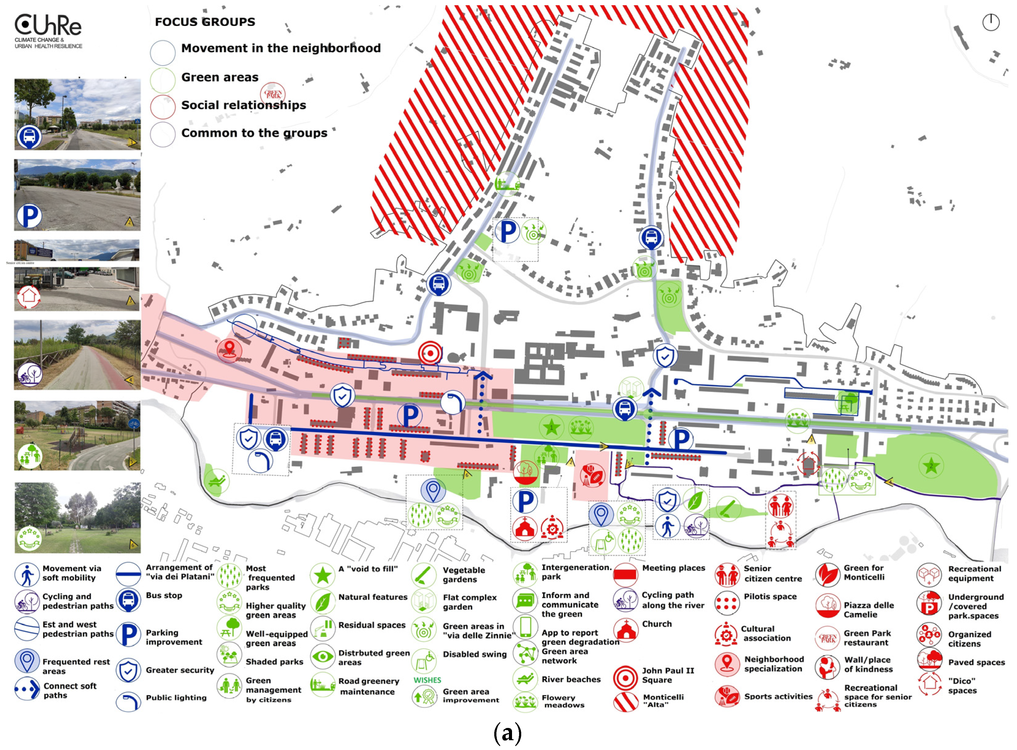
This part of the research aimed to directly involve the local community in identifying conflicts and positive aspects of neighbourhood life and health through a public debate, thereby initiating discussion on the most important questions and possible solutions for intervention. Three working groups were organized based on the main issues emerging from the household questionnaire and PASSI questionnaire, namely, road safety and sustainable mobility, green areas, and gathering places. Key questions were posed by the group facilitators: individual questions (i.e., about the way each participant experiences the neighbourhood); open questions (in which participants were invited to exchange opinions on issues raised by the facilitators); and a wish list (what the neighbourhood should look like in the future).
The groups then provided indications and suggestions for constructing the Criticality and Risks, Opportunities, and Desires maps, which served as the basis for formulating the project proposal for the regeneration and climate adaptation of the neighbourhood. With specific regard to the issue of ‘movement’, the questions regarded: going by bicycle and foot in the quarter; accessibility; attractiveness and ease of crossing the neighbourhood; car use; the use of public transport, and current design. With reference to the green areas, the questions and debate regarded: satisfaction and use; the sensations and provisions offered; care and maintenance of greenery; and ongoing projects. With reference to ‘social relationships’, the issue of satisfaction/dissatisfaction was investigated, along with the provision of gathering places and ongoing projects. The subsequent step was to build a repertoire of design actions and combinations of actions for design actions.
3.1.5. Climate and Health Actions
The reference for this area involved international best practices regarding the core topics of urban design—land use, mobility, open and meeting spaces, and green areas and the natural environment—and technological design—temporariness and flexibility, etc. These actions in key areas were related to people’s health and well-being based on scientific evidence from international research. The main study of reference was ‘Spatial Planning for Health’ by Public Health England, which developed a series of diagrams that illustrate and present proof of the connections between territorial planning and health based on the results of a literature review of the impacts of the built environment [
61]. These actions were used to build a design scenario for 2050.
3.1.6. Design Concept and Identification of Pilot Projects
Actions and integrations of actions were selected from among those that gave the most guarantees in terms of inclusiveness, safety, and environmental comfort with reference to the areas of interest emerging from the questionnaires and focus groups. These actions were identified spatially and form the basis for constructing small-scale pilot projects in places with the greatest social, climate, and design complexity in the neighbourhood according to the findings of the survey and assessments.
3.1.7. Assessment and Selection of Pilot Projects
The pilot projects, currently being developed, will be evaluated from the perspective of climate adaptation and implications for the health of neighbourhood residents to identify possible design alternatives up to 2050 in the ENVI-met and i-Tree environments. With regard to social sustainability, the projects will be compared at a public meeting with the local population and the City for final approval and dissemination of the project. These activities are still ongoing. They rely on a platform of sensors and automation technologies called Climate Health Lab (CHL) to provide real-time information/measurement of the physical/environmental conditions of the neighbourhood and its inhabitants to make projections to 2050. This platform can be implemented with contributions from citizens through the use of mobile crowdsensing techniques, which will allow smartphone users to interact with IoT devices. With the platform, it will therefore be possible to analyse and assess the difference between subjective and objective measurements of the quality-of-life indicators (atmospheric pollution, noise, temperature, perceived comfort, etc.) to understand how the perception of different environmental conditions in the quarter varies. The conclusion of the project involves verification and comparison of design scenarios, with the help of the researchers, technicians, and citizens through public encounters with the scope of helping the public administration in the decision-making process to regenerate the neighbourhood.
4. Results
The main results of the research are summarized below in reference to the different steps in the proposed methodology: (a) urban-planning investigation; (b) construction of the neighbourhood health and well-being profile; (c) construction of the climate profile; (d) participatory process with citizens: focus groups; (e) climate and health actions; (f) concept design and identification of pilot projects; (g) assessment and selection of pilot projects. As specified previously, some of these steps—specifically points (a), (b) and (c)—were developed before the pandemic. Others—(d), (e) and (f)—were developed during the COVID-19 lockdown. The last step, (g), is still being developed.
4.1. Results of the Urban-Planning Investigation
The urban-planning investigation entailed a critical reading of the quarter, analysing the existing urban planning tools and the state of the places in relation to demographic data, land use, green areas, commercial services, vehicular, bike, and pedestrian mobility, and the buildings. Monticelli is a neighbourhood of 7500 residents where half the population is older than 50 and children and teenagers represent only 14%. Some problems emerged from the analysis regarding the distribution of services and mobility. The four-lane central axis, the Via Salaria, supports rather high traffic volumes for a city in this Italian province, estimated to be about 2000 cars per hour, which is also due to the presence of the hospital. There have been many road accidents, even serious ones, in recent years. Commercial activities are mainly concentrated to the south of this road and in the east. The same can be said of the green areas. There is good and perhaps excessive parking. Cycling paths are mainly concentrated in the east along the Tronto River, and pedestrian paths are mainly to the north.
Overall, it emerged that Monticelli is a neighbourhood with:
Few children and many elderly people;
Sufficient but unequally distributed urban services and commercial activities;
Many green areas that are poorly equipped and differ little in their functions;
Few cycling paths and intense east–west vehicular traffic;
Few squares and places to gather, except the sports area and church grounds;
Few pedestrian paths, which are often degraded and concentrated only in the north;
Few areas of building degradation concentrated only in some areas and which are being renovated;
A substantial number of households with assistance (about 30% of the entire municipality before the pandemic) according to estimates by the local Caritas.
With regard to the distance to the main services, the investigation revealed that: 86% of the population is less than a 15-min walk from green sports areas; 94% are less than 5 min from a playground; and 83% are less than 15 min from commercial activities for everyday needs (
Figure 6). In addition, the planning of current public works reveals the fragmentation in the design proposals and the lack of a unifying design for urban regeneration, which leave practically unresolved the break between the northern and southern parts of the neighbourhood due to the axis for crossing the area, the Via Salaria.
4.2. Results Regarding the Neighbourhood Health and Well-Being Profile
The urban-planning analysis was followed by a questionnaire administered to families on the quality of life in the quarter and the PASSI investigation, used for the first time here in a neighbourhood. With regard to the family questionnaire, this relied on the collaboration of the Don Giussani Comprehensive Institute, the only one in the neighbourhood, which is very present in the social and cultural life of the area. Two hundred and fifty questionnaires were administered to the families of students (elementary and middle school) to learn about the habits and problems they face every day in the life of the neighbourhood and which may affect their health and quality of life.
The respondents consisted of 150 family representatives, mostly women, between 40 and 50 years of age, representing about 600 neighbourhood residents and about 8% of the total population.
The questions on life in the neighbourhood revealed that Monticelli is a place with few or even no parking problems for 64% of the sample. It is well connected or has few problems related to public transport (80% of the sample) and it is relatively or very congested for 48% of the sample. There are few or no crime-related issues for 59% of people. The neighbourhood is relatively clean for 55%, with road lighting problems for about 64% of the sample and street paving problems for 50%. This is a quarter in which green areas can be reached on foot in less than 15 min for 98% of respondents and where bike paths can be reached on bike in less than 5 min for 89.3% of respondents. Seventy-three percent of families frequent green areas and 64% regularly use the cycling paths. The PASSI questionnaire covered a sample of 205 people between the ages of 18 and 69. For the question about their perceived health, 90.2% of those interviewed said they were in good health, 74.1% perform their work mainly seated or standing, and 63.3% said they had done at least moderate physical activity in the previous month. Very few go to work by bike (4.3%) and few go on foot (19.0%). Of the respondents, 57.4% said that they do enough physical activity.
Both questionnaires were administered prior to the pandemic. The answers would probably be different today. Nevertheless, in a normal situation, this is what emerged and was confirmed in both interviews: a good state of health, both physical and mental; general satisfaction with the social climate in the neighbourhood, even if people do not know each other well and do not often participate in common activities; good accessibility to services and commercial activities. It seems that everything can be accessed easily or with little trouble, from public offices to schools and from commercial activities to green areas.
Despite these positive aspects, other aspects also emerged:
Another critical issue is the safety of walking at night. Sixty-six percent of people say they do not feel safe on the street at night. The sense of insecurity is due to the lack of public lighting (for 50% of people), a lack of law enforcement (40%), and the intensity and speed of vehicular traffic (just 30%). The results of these questionnaires led to a more in-depth investigation through focus groups with citizens.
4.3. Results Regarding the Climate Profile
Risk maps were created using remote sensing techniques, spatial data, and satellite images. The maps were designed to assess the growing impacts of climate change on urban infrastructure, health, and well-being, especially with regard to heat waves. In the GIS environment, it was possible to relate information about the population’s awareness of climate risks (children, elderly people, large families, etc.) to climate data and the urban morphology, identifying the most vulnerable areas. The analysis evidenced a vulnerable system scattered in multiple parts of the quarter (red zones). Widespread impermeability in parking areas, the absence or lack of trees in parks, and the presence of large sun-drenched open spaces are the biggest problems. This map already shows where the project will have to be situated, and a further investigation of the most problematic areas of land has been carried out using the fluid-dynamic simulation software ENVI-met and i-Tree to assess the economic, environmental, and water resources of the green areas on a small scale.
4.4. Results of the Participatory Process with Citizens: Focus Groups
Focus groups with neighbourhood inhabitants conducted remotely during the lockdown allowed us to investigate some aspects that had not been sufficiently explored. It was necessary to investigate the critical functional and spatial aspects of the neighbourhood with the local population in order to understand, for example, the low level of walking in the neighbourhood. A series of webinars were arranged during the lockdown involving about 40 adults of different ages and gender organized in three groups: movement in the neighbourhood, green areas, and social relationships. This was an open discussion fed by questions to encourage debate regarding: personal questions (personal opinions about different aspects of the neighbourhood), questions to provoke discussion, and a list of desires. Maps were drawn with contributions from citizens and a list of criticalities and risks, opportunities, and desires was produced (
Figure 8a,b). This list helped researchers to better understand the neighbourhood.
The focus groups during the lockdown influenced the responses from citizens regarding, for example, their satisfaction and dissatisfaction with slow mobility and the provisions in gathering spaces. The citizens often referenced the change in lifestyle during the lockdown and the growing value given to the presence of green areas and movement on foot and bicycle as conditions to ensure and implement in the future of the neighbourhood.
It emerged that:
Monticelli is a neighbourhood rich in potential and full of ‘activism’ that needs to ‘reconnect its various parts’. The people confirmed that they lived well in the neighbourhood, that the problem of addiction is only in a few areas, vandalism is isolated, but that there are criticalities that negatively affect the quality of life of individuals and families:
Most available open space is often fragmented and does not permit easy use by citizens or movement from one part of the quarter to another. There is a large amount of open space for parking and very few places to gather, except for the parish and neighbouring sports area;
Moving around by car is necessary, given the organization of the neighbourhood, even to go to school and do the daily shopping.
Some places and issues are more problematic than others:
The break due to the Via Salaria, which separates the northern and southern parts of the neighbourhood;
Overcrowding of the cycling path along the river;
The problem of safety along the road (little lighting, poor maintenance of the pavement);
The failure of cramped and dark pedestrian subways that people avoid;
The fragmentation, repetitiveness of green areas, and the inability to move between them easily due to the lack of connections, the lack of trees, which makes green areas uncomfortable in summer;
The non-use of certain meeting places such as the square, because it is decentralized and not very hospitable, especially in summer, due to the materials and lack of shade;
Critical issues related to the maintenance of the ‘upper pedestrian ways’; the distance from Monticelli Alta (the part of the district on the hill with low-density settlement);
Inefficient distribution of places and services that facilitate interaction and relationships, even among different generations.
It also emerged that during the lockdown, the ‘pilotis spaces’ (the open ground floors of some buildings, a characteristic of rationalist architecture) became opportunities for socializing and entertainment and that these spaces are used by the elderly to meet in the summer because they are protected from the sun.
The focus groups thus identified a number of priority areas for action to regenerate the neighbourhood:
The river park and connections with the neighbourhood;
The urban road, the Via Salaria;
The creation of public services and spaces for socialization for all ages.
4.5. Climate and Health Actions and Design Concept for 2050
A repertoire of climate and health design actions was then produced. About 70 actions were identified, divided with reference to two main topics—public spaces and mobility—and four subtopics—squares and open spaces; green and blue spaces; paths and pavements, active transport networks, home-school routes. For each of these subtopics, health outputs were identified based on the report ‘Spatial Planning for Health’ by Public Health England in 2017. The selected actions were used to build design scenarios up to 2050, which can guide future urban regeneration projects. The identification of these design actions enabled the construction of a Project Concept that selected the actions and groups of actions that give more guarantees in terms of inclusiveness, safety, and comfort with reference to the areas of interest (
Figure 9).
Among the design actions set out in the concept, which are based on safety, comfort, and inclusiveness, those related to the road system especially concern the reconfiguration of the east–west path of the Via Salaria, which will become an urban boulevard, with a resized central carriageway, the construction of an axis-park equipped for parking and waiting for public transport, and safety for pedestrian crossings by means of luminous signs on the ground. A radical transformation was also presented for the secondary streets, which will become ‘living’ roads, with limited speed (30 kph) and no distinction between vehicular and cycle paths, with raised crossings. The creation of pedestrian pathways connecting houses to the necessary shops and between the different green areas and gathering spaces in the neighbourhood will be essential in turning Monticelli into a neighbourhood of proximity.
Important actions to regenerate the land and adapt to climate change as well as improve the quality and use of urban spaces must necessarily be provided for: the desealing of land in many fully paved spaces (car parks); the realization of edible urban forests and naturalized, flower, and rustic meadows; the insertion of green city-river parks; the creation of an urban forest in the areas most subject to the heat island. All these actions will rely on NBS (nature-based solutions) for securing open spaces, squares, and roads.
The regeneration of the neighbourhood will then move onto improving and situating new services as emerging from the requests of citizens in the focus groups. In particular, the project entails the creation of: a library in the woods, pop-up parks, bike sharing, shelter houses, new local police headquarters, wall of kindness, nature lab, spaces for cultural events, enhancement of senior citizens clubs, etc.
The regeneration project for Monticelli cannot overlook interventions on private and semi-public spaces. To this end, interventions such as the following are suggested: green façades, green roofs, tree-lined courtyards, shared gardens, pocket parks, shared terraces/gathering spaces with temporary openings in pilot spaces on ground floors, etc.
All these actions guided the configuration of possible design alternatives to be verified through pilot projects (in the drafting phase), which will have to be evaluated and selected by means of fluid-dynamic simulations and interaction with the local population and city administration through a public meeting. The city administration will be charged with transferring the results of the research to interventions in the neighbourhood. To this end, the resources in the National Recovery and Resilience Plan (Piano Nazionale di Ripresa e Resilienza, PNRR), which falls under the Next Generation EU (NGEU) programme, represent an excellent opportunity to implement many of the solutions advanced. The design phase is expected to be completed by February 2022.
5. Discussion
From a summary of the experience in Monticelli, it would emerge that as it is now, the use of space in the district is divided into ‘micro neighbourhoods’, in which all the basic services are present, but they lack internally connected space, confirming a lack of continuity of open spaces and common spaces and services. All the projects initiated in recent years lack architectural and urban-planning quality and denote complete disinterest in the managerial aspects of public spaces. The design and realization of the neighbourhood in isolated parts led to the fragmentation of urban areas and social separation, especially between generations. Faced with this situation, the design key identified in the CCHURE research was to work on the rationalist urban layout and rediscover focus points in this layout that are very current and which constitute elements of discussion to reflect on during design:
Built spaces with their woven forms (characterized by the complementary relationship between buildings and streets);
Open forms (with independence of the direction of the street and the shape, placement, and location of the buildings where open spaces, which are almost always undefined, dominate);
Open spaces with vegetation (bordering the context and alternating between parts of the urban countryside, public green spaces, and courtyards);
Stone open spaces (where it is the road, with its rationalist layout, that becomes the star of an intense traffic flow that compromises the safety of the residents, divides parts of the settlement, and creates isolation);
Meeting places (almost always along the main routes or decentralized, underlining their inability to become social attractors on a local scale);
Paths (neglected, which are spread over the fabric, creating a micro network within the settlements themselves, little known and little used due to degradation and lack of security).
These ‘focus points’ constitute unexplored and unexpected resources to construct a new design paradigm, which views poorly defined spaces—designed for cars more than for people, but sizeable—as holding multiple potential roles for achieving the functional and relational quality that is lacking today and whose need has been highlighted by the pandemic. In this way, the demands of the inhabitants were interpreted with their needs for everyday spaces. The spatial configuration and reorganization of these relationships also needed to influence environmental aspects related to the climate change adaptation in a perspective to 2050, provide social opportunities for all ages, and ensure greater safety for residents, especially when walking and cycling. The next step in the process will be to evaluate the proposed solutions, first from the point of view of climate performance up to 2050 and then through discussion with citizens and administrators in concrete interventions.
6. Conclusions
The results presented above and the focus points of the spatial types and forms identified in the Discussion anticipate lines of research to test design responses. They indicate a field for testing how the issues of inclusiveness, health, and safety can constitute the services requested in a city of proximity with a view to climate change adaptation.
From this research, it can be said that the public city is still a planning laboratory today, albeit different from the past, with open frontiers to experiment with transformation according to new requirements. The thesis put forward at the beginning of the article and supported by the CCHURE research—in its focus on public suburbs of the second half of the twentieth century—is whether the theme of proximity, seen as functional and relational proximity and based on the requirements of inclusion, safety, and urban health, can play a structural role in: (a) the spatial and qualitative reconfiguration of urban space; and (b) contributing to reconstruction or just reinforcement of the system of relationships that are fundamental for empowering the local community. We can say ‘yes’, given the results of the CCHURE research, provided that there is a change in perspective when acting. This yields lines of research which in reality constitute defined fields and not hypothetical perspectives, in which we can begin experimentation, even in the perspective of providing answers for cities following COVID-19.
We conclude by identifying two fields of action: renewing the technical/cognitive/procedural tools that inevitably modify the traditional methodological approach and design innovations on the technical/social/spatial scale.
To do so, the first step is to renew the approach to understanding places and therefore research/action capable of regenerating inclusive places, activating forms and products of knowledge capable of expressing a mapping and a representation of places ‘from within’ based on a collaborative urban survey. This means once again renewing the so-called toolbox for transformative research through the contribution of new disciplinary knowledge, new modes of investigation, and evaluation such as: local inquiry and mapping, situating and engaging, visioning and reporting, and enabling [
62]. These new tools allow us to understand the gradients of peripherality, the resources that often fail to be intercepted with the recognized process of knowledge and the environmental and climate vulnerabilities that compromise the use and enjoyment of public space, revealing social empowerment and workshops for planning and wilfulness. This is the point of contact between the new criteria of the survey and what is found and discovered in the urban situation, which is rich in changing local identities and pushes for transformation that allow neighbourhoods to be designed inclusively (for example) between urban spaces, material urban relationships, relational densities, networks, enabling spaces, strategic frameworks, and/or evolutionary scenarios.
This is precisely what the CCHURE research does. From this point of view, the theme of proximity in the post-COVID city, in the paradigm of urban regeneration, must inevitably ‘hook’ space onto local capacities and resources, where space and territory become factors of inclusion, constituting a sort of enabling territory that recognizes residents as bearers of desires, capacities, and will, and therefore as part of social representation [
60]. It is a question of grasping the so-called daily transformative, cultural, and social trajectories but also realigning speeds between the consolidated city and suburbs, enhancing new forms of knowledge of the territory as a tool to guide actions, and creating project workshops to build urban policies together. These factors, both material and immaterial, represent a driver for achieving that urban spatial quality that, as noted when formulating the thesis in the introduction, Richard Sennet defined in ‘Building and Dwelling: Ethics for the City’, is better when there are more opportunities for the community to meet [
23] to develop the social interactions that constitute the very essence of the city [
24,
25,
26]. In this case, opportunities for meeting and the creation of social interactions emerge precisely from the new criteria of the toolbox described above and from the ability to implement tangible and intangible actions. This implies instrumental, cognitive, and procedural innovations.
At the same time, proximity—specifically with reference to council housing and from a more technical angle—leads to avenues of research in which a reflection on the value of the first urban layout of these neighbourhoods and their role in promoting urban regeneration in the consolidated city can be seen.
The rigidity of the original layout, now markedly rich in and full of voids, reveals itself as an available space for flexible uses and contemporary rethinking of the original urban layout itself through the concepts of temporariness, flexibility, and transience. This opens the door to experimentation with the focus points mentioned in the Discussion, which CCHURE has highlighted in the final phase of its research path based on method, procedures, and design. This involves addressing different aspects of the open space, urban space, residential settlement space, and the space/time variable in council housing settlements.
In the first case, it means becoming aware of public and private open space that is available and technically adaptable to point-like, systemic projects, nature-based solutions capable of responding to climate change, well-being, and urban quality of life. In this, the urban space is recognized as having a considerable degree of overall transformability on the neighbourhood level, which allows open space to be redesigned as a structuring system within the neighbourhood and as a connecting element with the neighbouring urban or periurban space.
Council housing settlements therefore become the scene for working with the community to test actions related to transitory urban planning. Precisely, in these unused or never realized and/or abandoned spaces, such planning finds fertile ground for development and rooting to begin an urban regeneration project even before the plan or the project itself. The already existing resources/criticalities are enhanced and leveraged in the short term, which is often requested by the community that lives there and breathes life into these places.
This type of planning is tied to the space–time variable understood as a space in which the community can act, allowing for uses and destinations that cannot be planned in advance, and where the role of inhabitants leads to empowerment through focus groups, forms of self-management, or forms of agreement being established, which, in relation to the dimension of the open space, presents quality design hypotheses for the public space. It is precisely not the public space that has historically structured, defined, and configured council housing settlements in Italy. Recognizing this potential and overcoming the rigidity/flexibility dichotomy may bring about a new project design, the expression of an answer to the most current urban-planning questions such as the climate crisis, well-being, and quality of life.

