
Selection of National Park Candidate Areas Based on Spatial Overlap Characteristics of Protected Areas in China


 ,
,  ,
,
Abstract
:1. Introduction
2. Materials and Methods
2.1. Data Sources
2.2. Research Methods
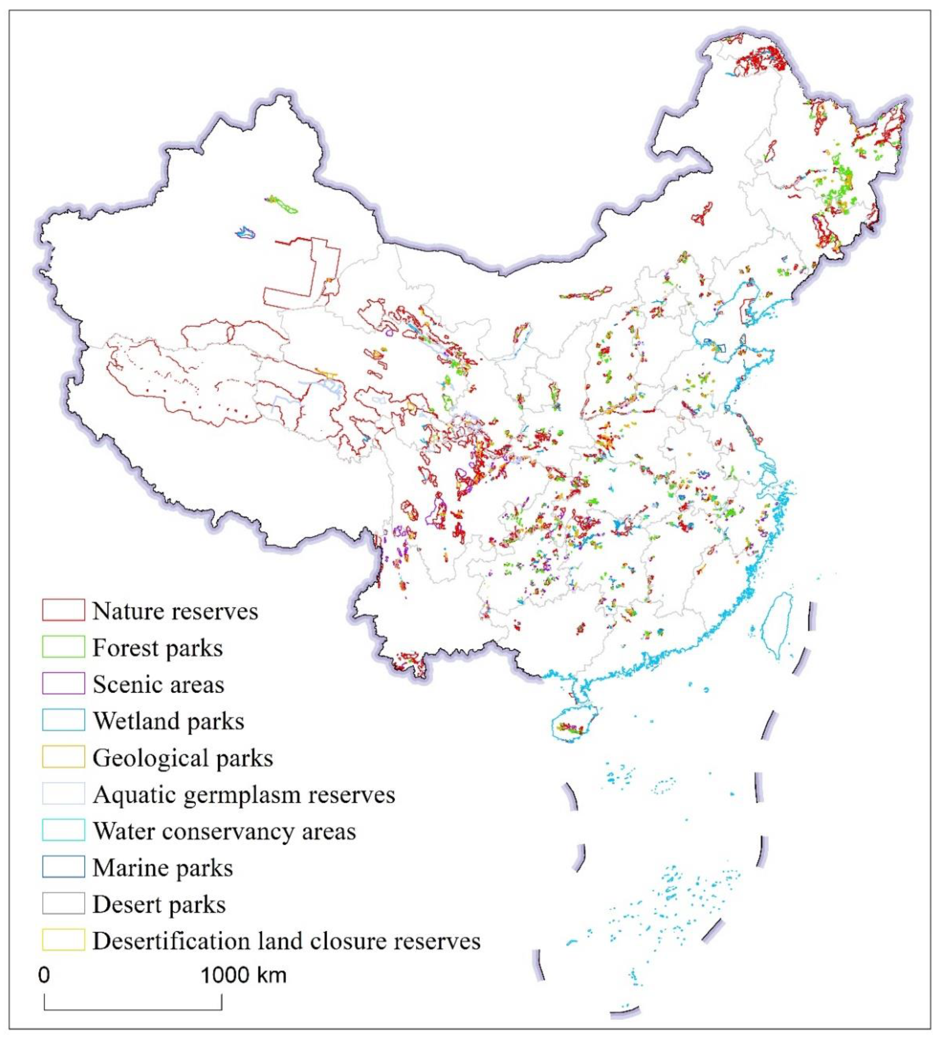
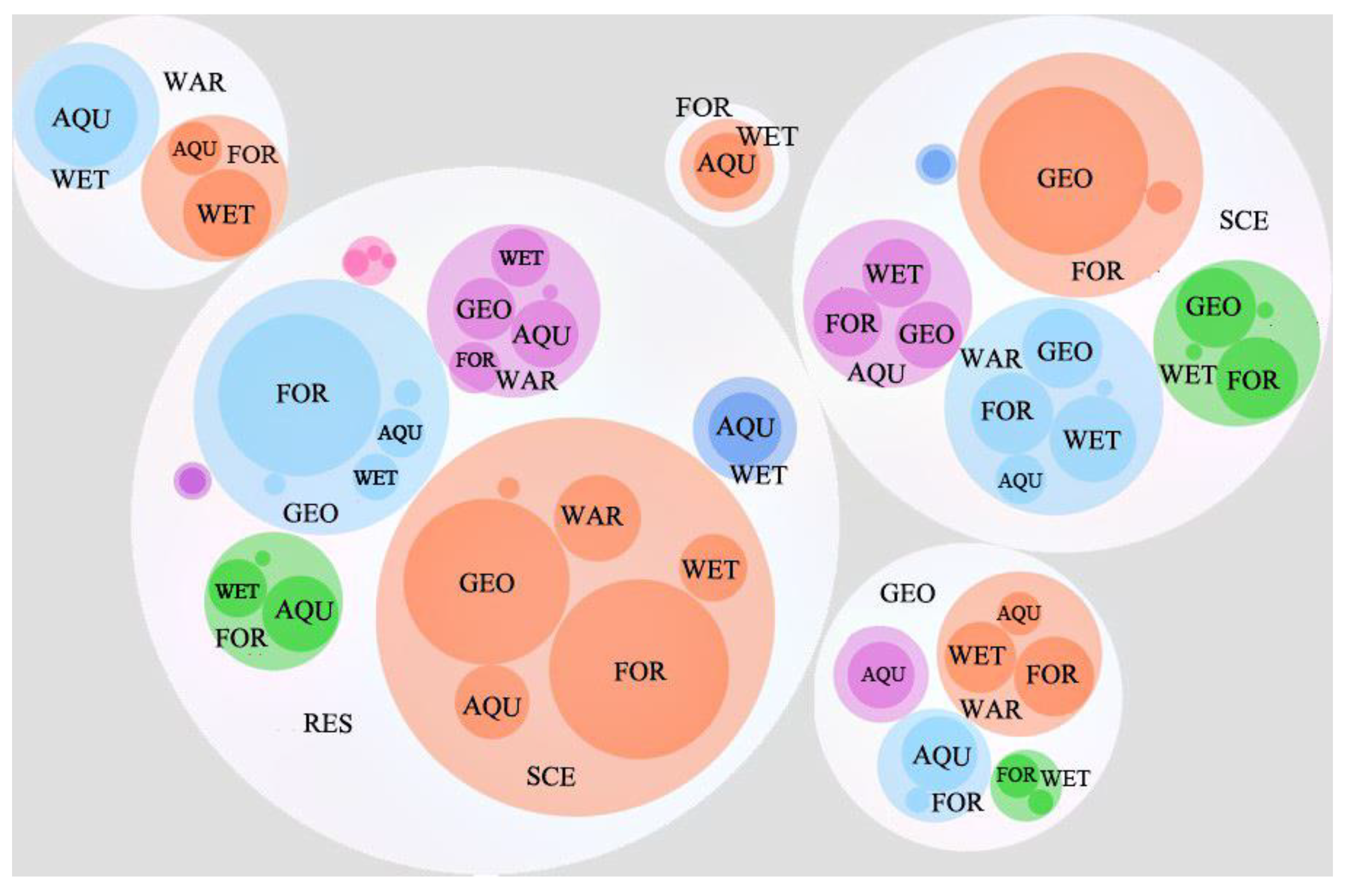
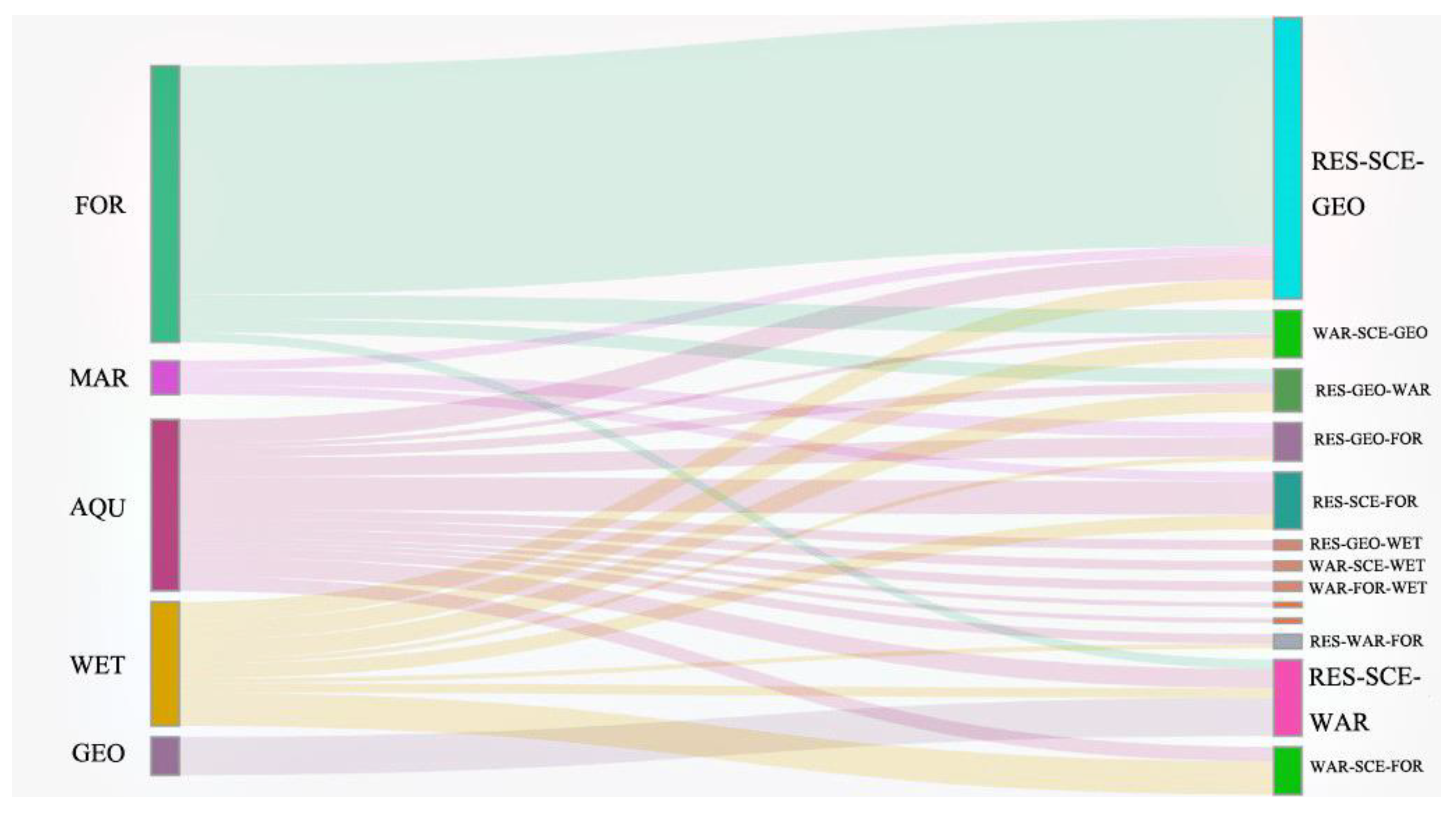
2.2.1. Overlap Analysis of Natural Protection Sites
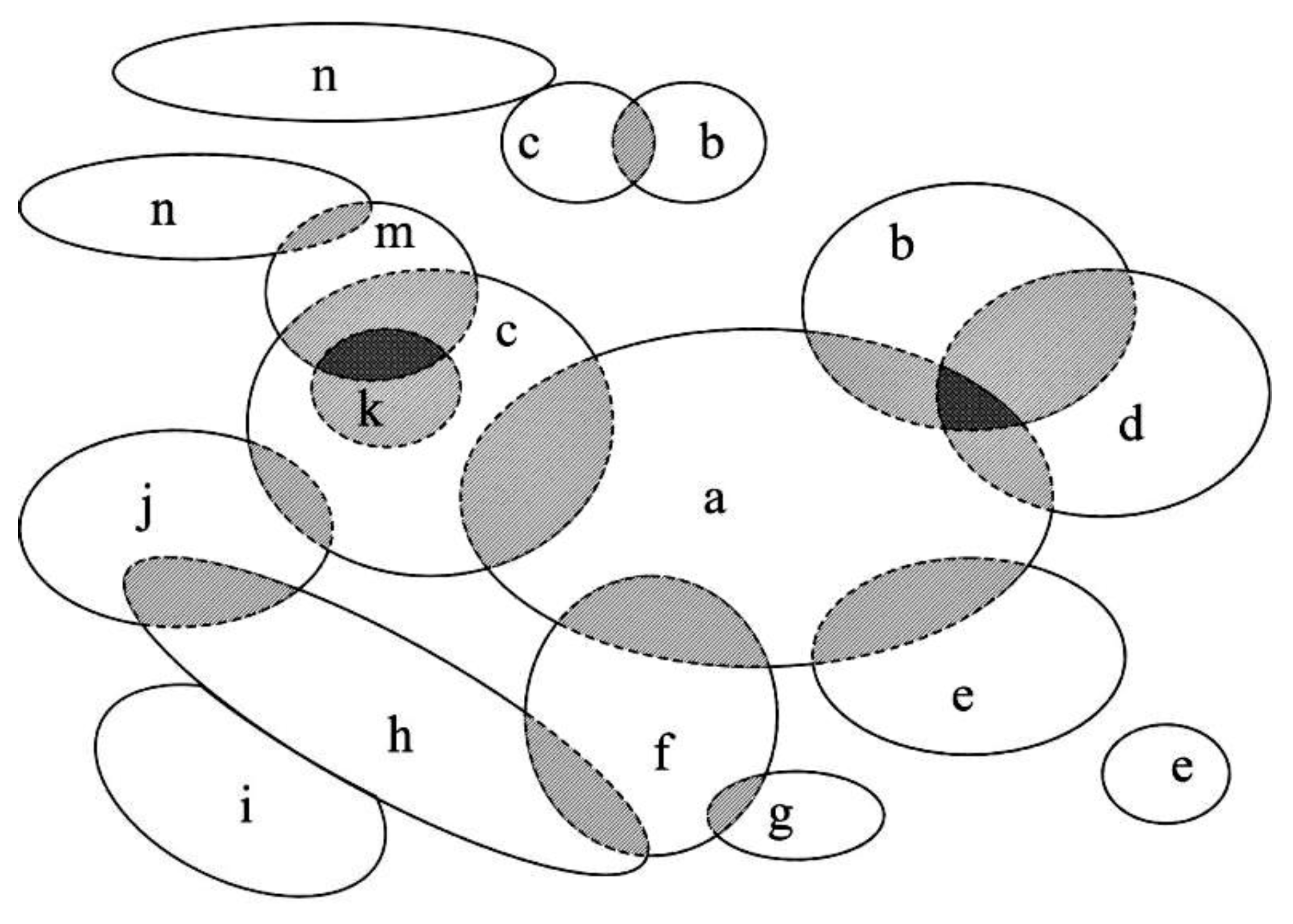
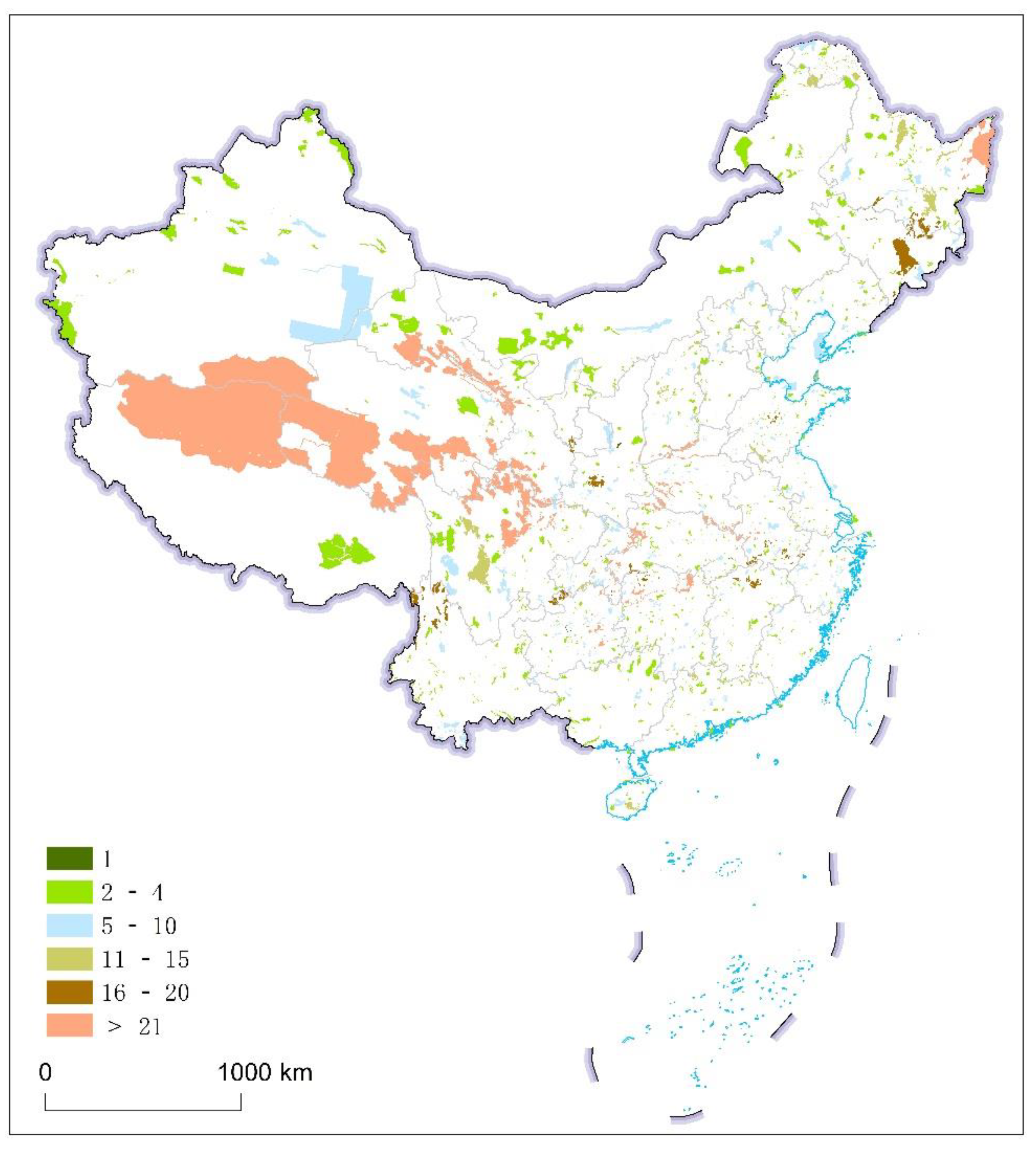
2.2.2. Construction of Continuous Areas Based on Protected Areas
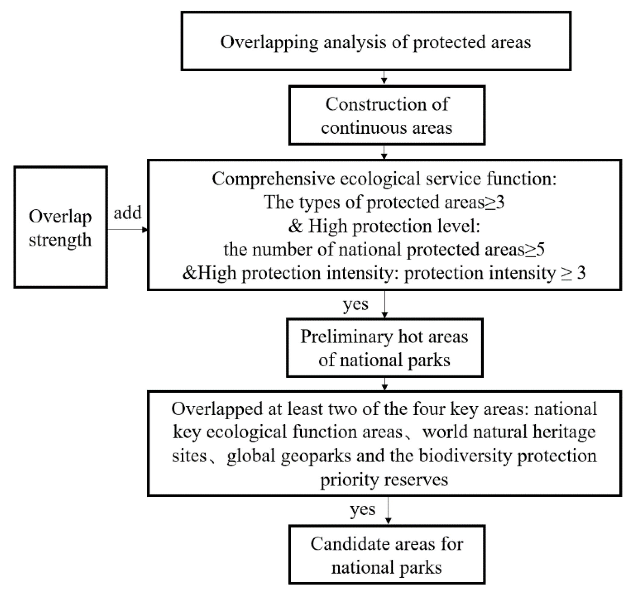
2.2.3. Selection of Candidate Areas for National Parks
- (1)
- Preliminary screening of Candidate areas for national parks
- (2)
- Rescreening based on key areas
3. Results
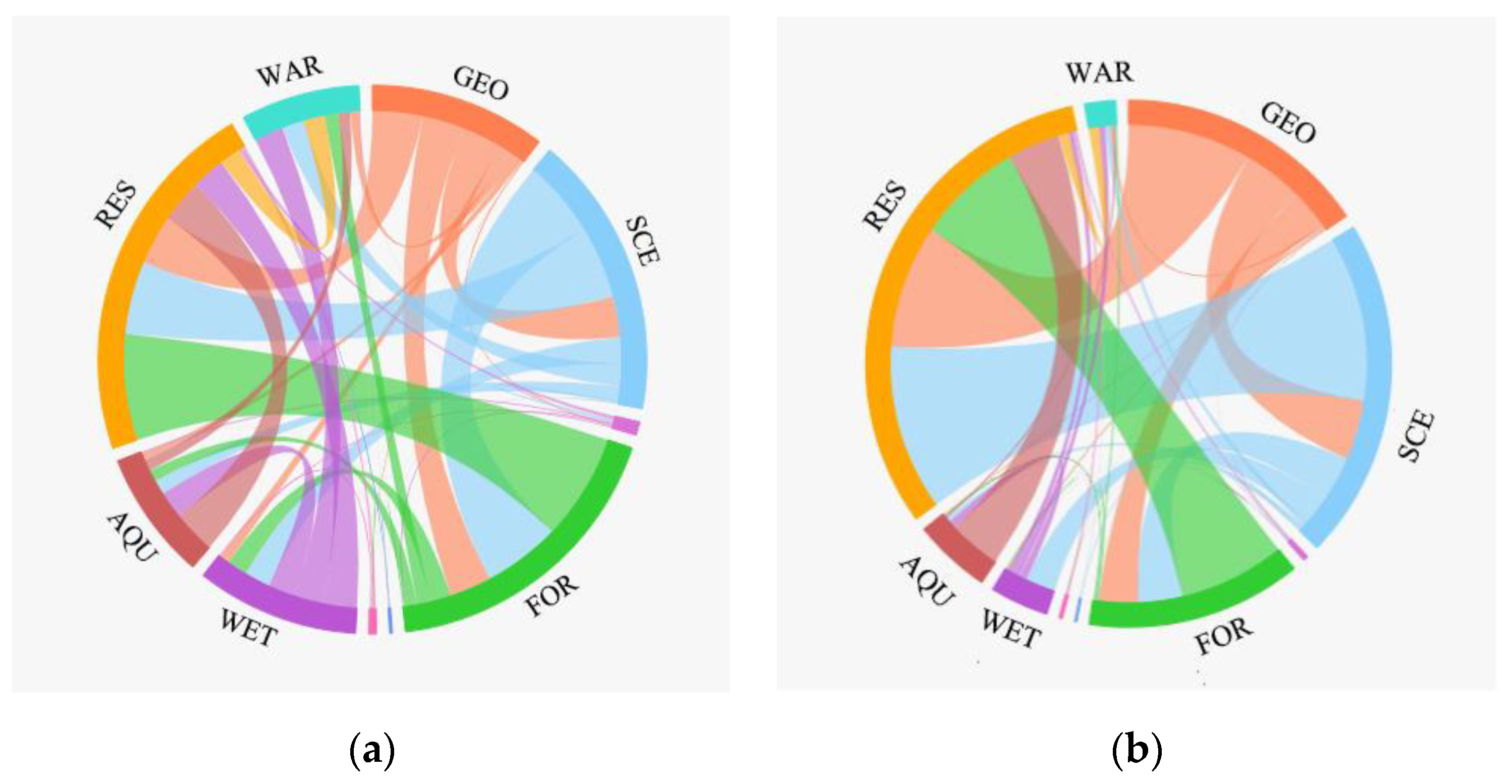
3.1. Protected Areas Overlap Relationship
3.2. Continuous Areas and Their Overlapping Features
- (1)
- Basic case of continuous area
- (2)
- Continuous region overlapping features
- (3)
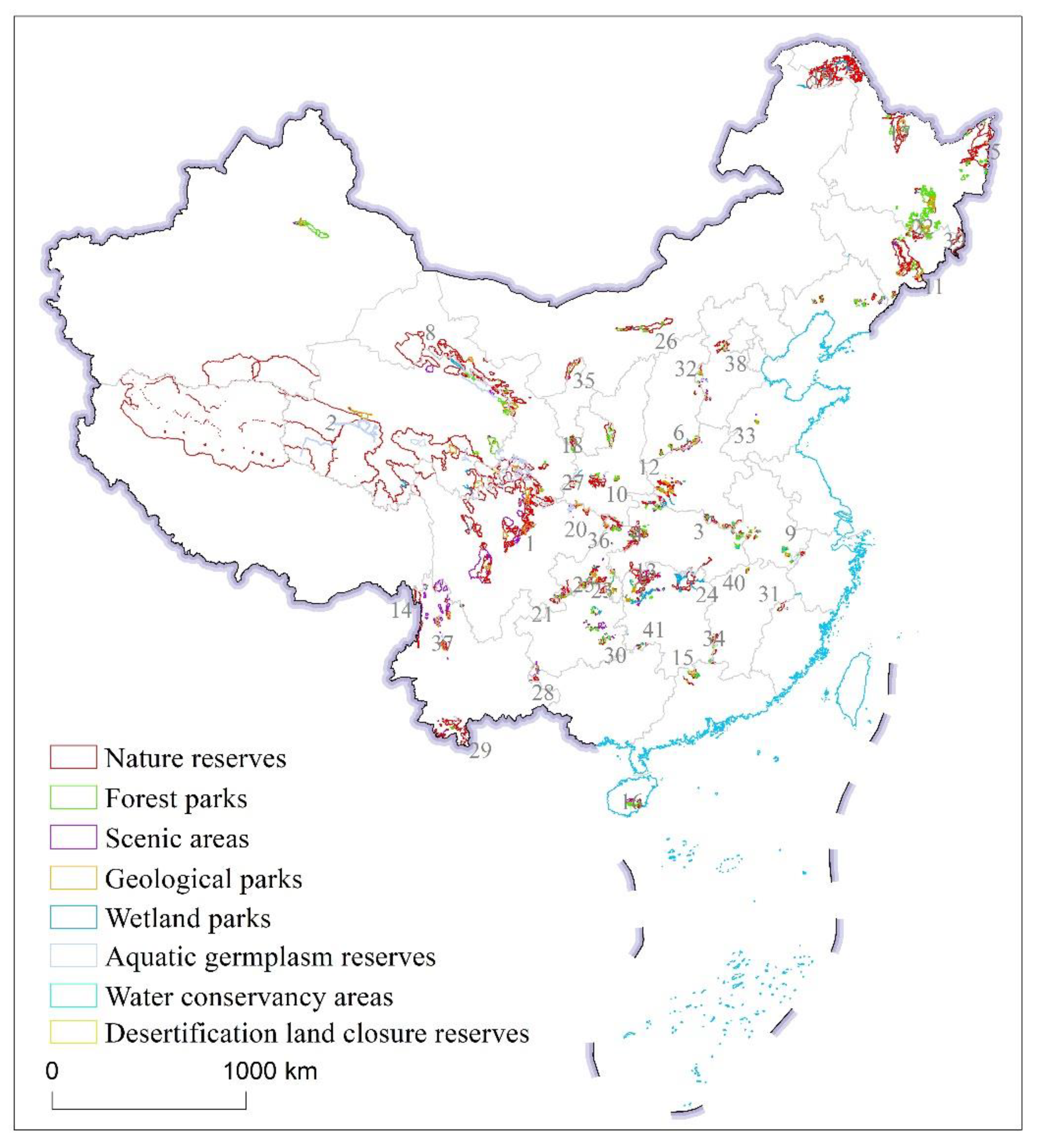
- The spatial relationship between continuous areas and key areas
3.3. Recommended Candidate Areas for National Parks in China
4. Discussion
4.1. Significance of the Study of Selection Strategy of National Parks Candidate Areas
4.2. The Shortages of the Overlapping and Contiguous Areas Analysis Method
5. Conclusions
Author Contributions
Funding
Acknowledgments
Conflicts of Interest
References
- Tang, F.L.; Lü, X.L.; Cai, F.; Sun, H.Y.; Luo, W.X. Reflections on integrated optimization schemes of protected areas. Landsc. Archit. 2020, 27, 8–13. [Google Scholar]
- Gao, J.X.; Liu, X.M.; Wang, C.; Wang, Y.; Fu, Z.; Hou, P.; Lü, N. Evaluating changes in ecological land and effect of protecting important ecological spaces in China. Acta Geogr. Sinica 2021, 76, 1708–1721. [Google Scholar] [CrossRef]
- Liu, X.M.; Fu, Z.; Wen, R.H.; Jin, C.P.; Wang, X.F.; Wang, C.; Xiao, R.L.; Hou, P. Characteristics of human activities and the spatio-temporal changes of national nature reserves in China. Geogr. Res. 2020, 39, 2391–2402. [Google Scholar]
- Gao, J.X.; Xu, M.J.; Zou, C.X. Development achievement of natural conservation in 70 years of new China. Chin. J. Environ. Manag. 2019, 11, 25–29. [Google Scholar]
- Zhu, C.Q. Perspective on development of national park system in China. Biodivers. Sci. 2014, 22, 418–420. [Google Scholar]
- Tang, F.L.; Wang, M.J.; Sun, H.Y. Reform path on management system of natural protected area. For. Constr. 2019, 1–5. [Google Scholar]
- General Office of the CPC Central Committee and General Office of the State Council of the PRC. The Guideline on the Establishment of Protected Area System with National Park as the Main Body. Available online: http://www.gov.cn/zhengce/2019-06/26/content_5403497.htm (accessed on 26 July 2019).
- Wang, M.J.; Sun, H.Y. Primary research on establishing protected area system dominated by national park. For. Constr. 2018, 1–5. [Google Scholar]
- Gao, J.X.; Liu, X.M.; Zhou, D.Q.; Ma, K.P.; Zhou, Q.; Li, G.Y. Some opinions on the integration and optimization of natural protected areas in China. Biodivers. Sci. 2021, 29, 290–294. [Google Scholar] [CrossRef]
- Papageorgiou, K.; Vogiatzakis, I.N. Nature protection in Greece: An appraisal of the factors shaping integrative conservation and policy effectiveness. Environ. Sci. Policy 2006, 9, 476–486. [Google Scholar] [CrossRef]
- Singh, S.; Sastry, A.R.K.; Mehta, R.; Uppai, V. Setting Biodiversity Conservation Priorities for India; World Wide Fund for Nature-India: New Delhi, India, 2000; pp. 680–690. [Google Scholar]
- Oldfield, T.E.E.; Smith, R.J.; Harrop, S.R.; Leader-Williams, N. A gap analysis of terrestrial protected areas in England and its implications for conservation policy. Biol. Conserv. 2004, 120, 303–309. [Google Scholar] [CrossRef]
- Pouzols, F.M.; Toivonen, T.; Minin, D.E.; Kukkala, A.S.; Kullberg, P.; Kuusterae, J.; Lehtomaeki, J.; Tenkanen, H.; Verburg, P.H.; Moilanen, A. Global protected area expansion is compromised by projected land-use and parochialism. Nature 2014, 516, 383–386. [Google Scholar] [CrossRef] [PubMed] [Green Version]
- Watson, J.E.M.; Dudley, N.; Segan, D.B.; Hockings, M. The performance and potential of protected areas. Nature 2014, 515, 67–73. [Google Scholar] [CrossRef] [PubMed]
- Jackie, Y.Y.; Richard, T.C.; David, D. A fine-scale gap analysis of the existing protected area system in Hong Kong, China. Biodivers. Conserv. 2004, 13, 943–957. [Google Scholar]
- Raphal, M.; Alain, T. Creation of a nature reserve, its effects on hunting management and waterfowl distribution in the Camargue (southern France). Biodivers. Conserv. 2002, 11, 509–519. [Google Scholar]
- Norman, M. Threatened biotas: “Hot spots” in tropical forests. Environmentalist 1988, 8, 187–208. [Google Scholar]
- Sankaran, R. Developing a protected area network in the Nicobar Islands: The perspective of endemic avifauna. Biodivers. Conserv. 1997, 6, 797–815. [Google Scholar] [CrossRef]
- Roger, K. Biodiversity, hotspots and defiance. Trends Ecol. Evol. 2000, 15, 484–485. [Google Scholar]
- Clark, F.S.; Slusher, R.B. Using spatial analysis to drive reserve design: A case study of a national wildlife refuge in Indiana and Illinoi s (USA). Landsc. Ecol. 2000, 15, 75–84. [Google Scholar] [CrossRef]
- Balmford, A. Conservation planning in the real world: South Africa shows the way. Trends Ecol. Evol. 2003, 18, 435–438. [Google Scholar] [CrossRef]
- Crowling, R.M.; Pressey, R.L.; Rouget, M.; Lombard, A.T. A conservation plan for a global biodiversity hotspot-the Cape Floristic Region, South Africa. Biol. Conserv. 2003, 112, 191–216. [Google Scholar] [CrossRef] [Green Version]
- Pierce, S.M.; Cowling, R.M. Systematic conservation planning products for land-use planning: Interpretation for implementation. Biol. Conserv. 2005, 125, 441–458. [Google Scholar] [CrossRef]
- Tang, X.P.; Jiang, Y.F.; Liu, Z.L.; Chen, J.Z.; Liang, B.K. Top-level design of the natural protected area system in China. For. Resour. Manag. 2019, 26, 1–7. [Google Scholar]
- Ouyang, Z.Y.; Xu, W.H. Integrating nature protection system and establishing national parks under legislation. Biodivers. Sci. 2014, 22, 425–426. [Google Scholar]
- Yu, H.; Zhong, L.S. Discussion on the selection criteria of national parks in China based on international. Acta Ecologica Sinica 2019, 39, 1309–1317. [Google Scholar]
- Wang, M.J.; Tang, F.L.; Sun, H.Y.; Zhang, G.X.; Yin, Z.J.; Zhang, T.X.; Yang, W.J. Preliminary exploration on the general layout of national parks in China. For. Constr. 2017, 2017, 7–16. [Google Scholar]
- Liu, G.M.; Yang, X.Z.; Lin, Y.; Tian, D. The spatial concentration characteristics and the rule analysis on the national forest park in China. Ecol. Econ. 2010, 131–134. [Google Scholar]
- Guo, Z.L.; Zhang, M.Y.; Cui, L.J.; Wang, D.A.; Wang, H.N.; Du, X. Establishment and dynamics of national wetland park system in China. Chin. J. Ecol. 2019, 38, 532–540. [Google Scholar]
- Pan, J.H.; Zhang, J.H. Spatial distribution characteristics and accessibility of national wetland parks in China. Chin. J. Ecol. 2014, 33, 1359–1367. [Google Scholar]
- Wu, J.Y. Study on spatial distribution characteristics of Chinese national parks. Geogr. Res. 2014, 33, 1747–1757. [Google Scholar]
- He, X.Q.; Wang, X.W.; Xiong, G.B.; Liu, Y. Study on the spatial distribution and its evolution of national geoparks in China. Areal Res. Dev. 2014, 33, 86–91. [Google Scholar]
- Sheng, Q.; Ru, H.J.; Li, Y.F.; Ni, Z.H. The distribution pattern of national aquatic germplasm reserves in China. J. Fish. China 2019, 43, 62–80. [Google Scholar]
- He, X.Q.; Wang, X.W. Spatial distribution of national mine parks of China. Sci. Technol. Manag. Land Resour. 2014, 31, 50–56. [Google Scholar]
- Qiu, P.; Zhang, R.J. On the influential factors and spatial distribution of national water parks’ in China-analysis based on the spatial-dependent model and the fix-effects model. J. Stat. Inf. 2009, 24, 47–53. [Google Scholar]
- Fu, L.Q.; Zong, C.; Kong, S.; Ma, J.Z. The spatial distribution of national protected areas and national scenic areas and ecotourism potential analysis. Chin. J. Wildl. 2015, 36, 218–223. [Google Scholar]
- Kong, S.; Zeng, D.; Yang, Y.B.; Ma, J.Z. Spatial differences comparison between national protected areas and national forest park. J. Northeast. Agric. Univ. 2013, 44, 56–61. [Google Scholar]
- Jiang, C.; Ma, S.G.; Wang, Q.S.; Kong, S.; Ma, X.; Zong, C. Spatial distrbuyion pattern of five major categories of protected area in China. Chin. J. Wildl. 2016, 37, 61–66. [Google Scholar]
- Zhou, J.; Zhang, J.H.; Chen, J.; Li, M. Analysis of spatial structure on wetland protected areas, wetland parks and international important wetlands in China. Wetl. Sci. 2014, 12, 597–605. [Google Scholar]
- Fan, H.L.; Wang, F. Similarities and differences in spatial distribution and its influencing factors of two kinds of national wetland parks in China. Acta Sci. Nat. Univ. Pekin. 2016, 52, 535–544. [Google Scholar]
- Ma, K.; Tang, X.L.; Liu, S.Y.; Wang, Y.W.; Ren, Y.J.; Liu, X.H. Study on spatial distribution characteristics of national protected areas and the space strategy of national park corridor in the Yangtze River basin. Resour. Environ. Yangtze Basin 2018, 27, 2053–2069. [Google Scholar]
- Chen, B.; Zhu, Y.P.; Lou, J.W.; Ji, Y.C.; Xin, L.J.; Wang, W. Relationships between national protected areas and other types of protected areas in Yunnan province. Ecol. Econ. 2015, 31, 129–135. [Google Scholar]
- Jin, Y.; Zhou, X.; Shu, L.R. A Study on the integration and boundary adjustment of Chinese national landscape resorts. Planners 2019, 35, 50–55. [Google Scholar]
- Yang, Z.; Cheng, K.; Fu, L.Q.; Zong, C.; Ma, J.Z. Spatial overlapping analysis for protected areas, forest parks and wetland parks in forestry management system of Northeast China. Chin. J. Ecol. 2017, 36, 3305–3310. [Google Scholar]
- Jin, C.P.; Liu, X.M.; Wang, X.F.; Sun, Y.Y.; Fu, Z.; Wang, C.; Hou, J. Overlapping relationship of the protected area boundary in the Yangtze River economic beltand its integration countermeasures. Acta Ecol. Sinica 2020, 40, 7323–7334. [Google Scholar]
- Lü, C.; Zeng, Q.; Lei, G.C. Ecosystem service-based protected area category system. Chin. Landsc. Archit. 2017, 33, 19–23. [Google Scholar]

| Type | Number | Area (km2) |
|---|---|---|
| Geological park | 397 | 46,811.86 |
| Scenic area | 812 | 107,277.16 |
| Marine park | 60 | 13,768.61 |
| Forest park | 1647 | 79,634.96 |
| Desertification land closure reserve | 17 | 2415.93 |
| Desert park | 80 | 2846.32 |
| Wetland park | 1249 | 32,660.69 |
| Aquatic germplasm reserves | 514 | 46,074.18 |
| Water conservancy area | 626 | 6361.48 |
| Nature reserves | 1512 | 1,383,398.12 |
| Total | 6914 | 1,721,249.31 |
| Type | Geological Park | Scenic Area | Marine Park | Forest Park | Desertification Land Closure Reserve | Desert Park | Wetland Park | Aquatic Germplasm Reserve | Water Conservancy Area | Nature Reserve |
|---|---|---|---|---|---|---|---|---|---|---|
| Geological park | - | 210 | 6 | 217 | 0 | 2 | 51 | 35 | 47 | 258 |
| Scenic area | 210 | - | 14 | 400 | 1 | 3 | 134 | 74 | 115 | 375 |
| Marine park | 6 | 14 | - | 7 | 0 | 0 | 5 | 10 | 1 | 19 |
| Forest park | 217 | 400 | 7 | - | 0 | 5 | 105 | 61 | 73 | 549 |
| Desertification land closure reserve | 0 | 1 | 0 | 0 | - | 3 | 0 | 1 | 1 | 5 |
| Desert park | 2 | 3 | 0 | 5 | 3 | - | 4 | 0 | 3 | 13 |
| Wetland park | 51 | 134 | 5 | 105 | 0 | 4 | - | 141 | 149 | 173 |
| Aquatic germplasm reserve | 35 | 74 | 10 | 61 | 1 | 0 | 141 | - | 59 | 222 |
| Water conservancy area | 47 | 115 | 1 | 73 | 1 | 3 | 149 | 59 | - | 108 |
| Nature reserve | 258 | 375 | 19 | 549 | 5 | 13 | 173 | 222 | 108 | - |
| Suggested Area | National Number | Number of Protected Area Types | Protection Strength | Overlapping Intensity | Main Overlapping Areas and Names | Representative National Nature Protected Land |
|---|---|---|---|---|---|---|
| Panda * | 43 | 7 | 46 | 0.15 | ST: Sichuan–Yunnan forest; SZ: Jiuzhaigou, Huanglong, giant panda habitat; SW: Minshan–Hengduan Mountain area | N (Jiuzhaigou, Tangjiahe, Wolong, etc.), S (Siguniang Mountain, Jiuzhaigou-Huanglong Temple, etc.), and G (Huanglong, etc.) |
| Three river source region * | 23 | 8 | 12 | <0.01 | ST: Source of the Yangtze River, Yellow River Source, Algin; SZ: Hoh Xil; SD: Kunlun Mountain; SW: Qiang Tang Sanjiangyuan | N (Sanjiangyuan, Hoh Xil, Qiangtang, etc.), G (Qinghai Maqin, Animqing, etc.), W (Yushu Batang, etc.) A (Gequ River, etc.) |
| Dabie Mountain | 31 | 7 | 20 | 0.73 | ST: Dabie Mountain, source of Huaihe River; SD: Dabie Mountain; SW: Dabie Mountain | N (Dabie Mountain, Liankang Mountain, Jinzhai Tianma, etc.), G (Dabie Mountain, etc.), F (Huangbai Mountain, etc.), W (Paradise Lake, etc.), A (Ten Thousand Buddha Lake, etc.), C (Foziling, etc.) |
| Shennongjia-The Three Gorges * | 20 | 6 | 22 | 0.53 | ST: The Three Gorges Reservoir Area, the South-to-North Water Diversion Project; SZ: Shennongjia; SD: Shennongjia; SW: Daba Mountain | N (Shennongjia, Dajiu Lake) W (Badong Golden silk monkey, etc.), S (Yangtze Three Gorges, etc.), G (sinkhole seam, etc.), W (Dajiu Lake), F (Shennongjia, Yichang Longmen River, etc.) |
| Three River Plain | 22 | 5 | 22 | 0.11 | ST: Sanjiang Plain Wetland; SW: Sanjiang Plain District | N (Sanjiang, Dali River, Pauli River, Northeast Black Bee, Treasure Island, etc.), F (Wandashan, etc.), and W (Raohe Uzuli River, etc.) |
| South Taihang Mountain | 18 | 6 | 12 | 0.52 | SD: Wangwu Mountain-Dai Meishan, Yuntai Mountain; SW: Taihang Mountain area | N (Alexandria, Taihang Mountain macaque, Yangcheng Mang Macaque), S (Yuntai Mountain), G (Wangwu Mountain, Lingchuan Wangmang Mountain), F (Yuntai Mountain, etc.), W (Dan River, Zezhou) |
| Wuling Mountain | 21 | 7 | 10 | 0.59 | ST: Wuling Mountain Mountain; SW: Wuling Mountain District | N (Gaowangjie, Borrowing Mother Creek), S (Mengdong River, Dehang), G (Hunan Ancient Zhang Red Stone Forest), F (Xiaozhai, Sitting Long Gorge, etc.), W (Wuqiang Creek, etc.) |
| Qilian Mountain * | 14 | 7 | 8 | 0.23 | ST: The Black River Basin; SW: The Qilian Mountains | N (Gansu Qilian Mountain, Liancheng, Yanchi Bay), G (Zhangye, etc.), F (Beishan, Qinghai, etc.), W (Qilian Black Heyuan), C (Daynokou Reservoir) |
| Mount Huang | 12 | 7 | 9 | 0.78 | ST: Water conservation in the upper reaches of the Xin’an River; SZ: Huangshan; SD: Huangshan; SW: Huangshan–Huaiyu District | N (Anhui Qingliang Peak, etc.), S (Huangshan, Longchuan, Huashan Mystery Cave-gradual River), G (Anhui Huangshan), F (Huizhou, Huangshan), W (Taiping Lake) |
| Qinling Mountains | 13 | 4 | 18 | 0.02 | ST: Qinba biodiversity; SW: the middle section of the Qinling Mountains | N (Taibai Mountain, Foping, Huangbai Plateau, Old County, etc.), F (Shaanxi Heihe, Taibai Mountain) |
| Paekdusan | 15 | 6 | 11 | 0.09 | ST: Changbai Mountain Forest; SW; West section of Changbai Mountain | N (Changbai Mountain, Ji’an, Songhua River Three Lakes, Tonghua Shihu), S (Songhua Lake), G (Jingyu Volcano, Fusong), F (Jilin Shihu, Wunu Peak, Quan Yangquan) |
| The Funiu Mountians | 12 | 6 | 9 | 0.27 | ST: Water source area of the middle route of the South-to-North Water Diversion Project; SD: Funiu Mountain;SW: Qinling District | N (Funiu Mountain, Baotianman, Nanyang Dinosaur Egg Fossil Group, etc.), G (Funiu Mountain, Baotian Man, etc.), F (Baiyun Mountain, etc.), C (Shimen Lake, Xixia County) |
| Zhangjiajie | 8 | 5 | 7 | 0.30 | ST: Wuling Mountain District; SZ: Wulingyuan; SD: Zhangjiajie; SW: Wuling Mountain District | N (Eight Dagong Mountain, Seven Sister Mountain, Zhangjiajie Giant Salamander), S (Wulingyuan), F (Zhangjiajie, Tianmen Mountain), and C (Zhangjiajie Loujiang) |
| Three rivers and flows * | 8 | 7 | 9 | 0.29 | ST: Northwest Yunnan; SZ: parallel current of three rivers; SW: South section of Hengduan Mountain | N (Galigong Mountain), S (Yulong Snow Mountain, Three Rivers), G (Yunnan Yulong Snow Mountain Glacier, Lijiang Laojun Mountain), F (Yunnan Feilai Temple), W (Qinghuadian) |
| Nanling Mountains | 9 | 7 | 6 | 0.72 | ST: Nanling; SZ: Danxia, China; SW: Nanling | N (Nanling, Mangshan), G (Guangdong Yangshan), F (Jiulong River), and W (Nanshui Lake) |
| Wuzhishan * | 8 | 3 | 14 | 0.53 | ST: Central Hainan Island; SW: South-central Hainan Island | N (Wuzhishan, Hangluo Mountain, Yingge Ling), F (Hainan Qixian Ling, Hangluo Mountain) |
| Xiao Hinggan Mountains | 10 | 7 | 13 | 0.43 | ST: Small Hinganling Forest; SW: lesser Khinganling District | N (Cuibei Wetland), S (Dazhu River), F (Dazhan River, etc.), and W (Hoji River) |
| Liupan Mountains | 9 | 6 | 7 | 0.58 | ST: Loess Plateau; SW: Liupan Mountain Meridian Ridge | N (Liupan Mountain), S (Kongtong Mountain), G (Kongtong Mountain Danxia), F (Liupan Mountain, etc.) |
| Da Hinggan Mountains | 8 | 3 | 8 | 0.04 | ST: Greater Hinggan Mountains Forest; SW: Greater Hinggan Mountains District | N (Chona River, Greater Khinggan Mountains Khan Horse, Huzhong), W (Huma River Source) |
| Micang Mountain | 7 | 4 | 7 | 0.96 | ST: Qinba biodiversity; SD: Guangwu Mountain–Nuoshui River; SW: Daba Mountain | N (Micang Mountain), S (Guangwu Mountain-Nuoshui River, Micang Mountain), G (Guangwu Mountain-Nuoshui River), A (Jiaojiahe Chongcleavage fish) |
| The downstream of the Chishui River | 9 | 4 | 10 | 0.95 | SZ: Danxia, China; SW: Wuling Mountain District | N (Chishui tree-fern), S (Simianshan), G (Chishui Danxia), F (Xishui) |
| Mirror Park Lake–Great Tiger Mountain | 19 | 6 | 10 | 0.49 | ST: Changbai Mountain Forest; SD: Jingpo Lake; SW: Changbai Mountain District | N (Yanming Lake, Beihu Lake), S (Jingpo Lake), G (Jingpo Lake), F (Heilongjiang Craa, Xuexiang, etc.), W (source of Jingpo Lake), A (Wave River) |
| Middle and lower reaches of Wujiang River | 12 | 7 | 9 | 0.42 | ST: Wuling Mountain District; SW: Wuling Mountain District | N (Mayang River), S (Wujiang Mountain Gorge), G (Youyang), F (Qianjiang) |
| The Dongting Lake | 20 | 5 | 9 | 0.08 | ST: New; SW: Dongting Lake District | N (East and West Dongting Lake, etc.), S (Yueyang Tower–Dongting Lake), W (Miluo River, etc.) |
| Jin Foshan | 12 | 6 | 10 | 0.99 | SZ: karst, South China; SW: Wuling Mountain District | N (Jinfo Mountain, Dasha River), S (Jinfo Mountain), G (Wansheng), F (Montenegro) |
| Great Castle Peak | 7 | 4 | 5 | 0.15 | ST: Grassland at the northern foot of Yinshan Mountain; SW: West Ordos–Helan Mountain–Yinshan Mountain | N (Inner Mongolia Daqingshan), F (Wula Mountain, Chilechuan, Wu dangzhao, etc.), W (Kunduron River), C (Hasuhai) |
| Xiaolongshan | 7 | 6 | 5 | 0.01 | ST: Qinba biodiversity; SW: Qinling Mountains | N (Xiaolong Mountain, Zibai Mountain), F (Zibai Mountain, Wulong Cave), W (Fengxian County Jialing River) |
| Southwest Guizhou | 6 | 5 | 4 | 0.07 | ST: Stone desertification control of karst in Yunnan and Guizhou; SW: Limestone area of western Guizhou | N (Jinzhong Mountain Black-tailed Pheasant), S (Maling River Canyon), G (Xingyi) |
| Xishuangbanna | 6 | 4 | 5 | 0.10 | ST: Sichuan–Yunnan forest; SW: Xishuangbanna District | N (Xishuangbanna, Nadal River Basin), S (Xishuangbanna), F (Xishuangbanna) |
| Miaoling Mountains | 9 | 7 | 3 | 0.14 | ST: Prevention and control of rocky desertification in karst, Guizhou, Yunnan; SZ: karst, South China; SW: Nanling | N (Leigong Mountain), S (Wuyang River), G (Miaoling, Qiandongnan), F (Leigong Mountain, Taijiang, etc.), and W (Wengyou River) |
| Mount Wuyi * | 5 | 4 | 5 | 0.002 | SZ: Wuyi Mountain; SW: Wuyi Mountain District | N (Fujian Wuyi Mountain, Jiangxi Wuyi Mountain), S (Wuyi Mountain), F (glossy Wuyi Mountain) |
| Camel Beam | 9 | 6 | 5 | 0.76 | ST: new added; SW: Middle section of Taihang Mountain area | N (Camel Liang), S (Xibaipo-Tiangui Mountain), G (Fuping Tiansheng Bridge), F (Pingshan Camel Liang, Wuyue Village, Tiansheng Bridge), A (Zhongshan Lake, and Po Lake) |
| Mount Taishan | 6 | 5 | 3 | 3.61 | ST: New; SZ: Mount Tai | S (Taishan, Qianfoshan), G (Taishan), F (Taishan, Pharmaceutical Township) |
| Jinggangshan | 8 | 4 | 10 | 0.39 | ST: Nanling Mountain; SW: Nanling | N (Nanfeng Face, Qiyun Mountain), S (Jinggangshan), F (Shennong Valley, Qiyun Mountain) |
| The Helan Mountains | 5 | 4 | 5 | 0.14 | ST: New added; SW: West Ordos-Helan Mountain–Yin Mountain | N (Inner Mongolia Helan Mountain, Ningxia Helan Mountain), S (Xixia Mausoleum), F (Sukou) |
| Daba Mountain | 9 | 6 | 7 | 0.31 | ST: Qinba biodiversity; SW: Middle section of Daba Mountain | N (Daba ashan, Xueaoshan), F (Hongchi Dam), W (Qianstorey River, Zhenpingshu Heyuan) |
| Cangshan Erhai Lake | 6 | 6 | 3 | 2.89 | ST: Sichuan and Yunnan; SD: Cangshan; SW: South section of Hengduan Mountain | N (Cangshan Lake and Erhai Lake), S (Dali Lake), G (Dali Lake and Cangshan Lake), and W (Eryuan West Lake Lake) |
| West Beijing | 5 | 4 | 8 | 0.34 | SD: Fangshan; SW: Taihang Mountain District | N (Baihua Mountain, Little Wutai Mountain), S (Wild Sanpo), F (Wild Sanpo, Xiaolongmen) |
| Northeast Tiger Leopard * | 6 | 3 | 7 | 0.004 | ST: Changbai Mountain Forest; SW: Changbai Mountain District | N (Hunchun Siberian Tiger, Sailing Northeast Tiger), S (Anti–Sichuan), A (Hunchun River) |
| Lushan Mountain | 6 | 4 | 3 | 0.26 | SD: Lushan Mountain; SW: Poyang Lake District | N, S, G(Lushan), F (Lushan Mountain Shannan, Mazu Mountain, smallpox Well) |
| Nam Son * | 5 | 4 | 3 | 0.11 | ST: Nanling Mountain; SW: Nanling | B (Jintong Mountain), S (Nanshan), F (Liangjiang Canyon), W (Chengbu Baiyun Lake) |
Publisher’s Note: MDPI stays neutral with regard to jurisdictional claims in published maps and institutional affiliations. |
© 2022 by the authors. Licensee MDPI, Basel, Switzerland. This article is an open access article distributed under the terms and conditions of the Creative Commons Attribution (CC BY) license (https://creativecommons.org/licenses/by/4.0/).
Share and Cite
Liu, X.; Wang, C.; Jiang, D.; Wang, Y.; Gao, J.; Jin, C.; Ma, W.; Yuan, J. Selection of National Park Candidate Areas Based on Spatial Overlap Characteristics of Protected Areas in China. Sustainability 2022, 14, 2578. https://doi.org/10.3390/su14052578
Liu X, Wang C, Jiang D, Wang Y, Gao J, Jin C, Ma W, Yuan J. Selection of National Park Candidate Areas Based on Spatial Overlap Characteristics of Protected Areas in China. Sustainability. 2022; 14(5):2578. https://doi.org/10.3390/su14052578
Chicago/Turabian StyleLiu, Xiaoman, Chao Wang, Dong Jiang, Yong Wang, Jixi Gao, Chuanping Jin, Wandong Ma, and Jingfang Yuan. 2022. "Selection of National Park Candidate Areas Based on Spatial Overlap Characteristics of Protected Areas in China" Sustainability 14, no. 5: 2578. https://doi.org/10.3390/su14052578
APA StyleLiu, X., Wang, C., Jiang, D., Wang, Y., Gao, J., Jin, C., Ma, W., & Yuan, J. (2022). Selection of National Park Candidate Areas Based on Spatial Overlap Characteristics of Protected Areas in China. Sustainability, 14(5), 2578. https://doi.org/10.3390/su14052578