Article

Selection of National Park Candidate Areas Based on Spatial Overlap Characteristics of Protected Areas in China

1
Department of Ecological Remote Sensing, Ministry of Ecology and Environment Center for Satellite Application on Ecology and Environment, Beijing 100094, China
2
State Key Laboratory of Resources and Environmental Information System, Institute of Geographic Sciences and Natural Resources Research, Chinese Academy of Sciences, 11A Datun Road, Beijing 100101, China
3
Chinese Research Academy of Environmental Sciences, Beijing 100012, China
*
Authors to whom correspondence should be addressed.
Sustainability 2022, 14(5), 2578; https://doi.org/10.3390/su14052578
Submission received: 8 December 2021 / Revised: 16 February 2022 / Accepted: 19 February 2022 / Published: 23 February 2022

Abstract

:
The integration and optimization of protected areas is an important part of the construction of a protected areas system centered around national parks. How to best integrate and optimize protected areas is the most urgent problem in the reform. This paper analyzes the spatial overlap and continuity of protected areas in China on a national scale and proposes a collection of candidate areas for national parks. The results show that ➀ 52.9% of the protected areas overlap, with nature reserves, forest parks and scenic areas showing the most overlap, and the maximum number of overlaps is five. ➁ There are 1145 groups of contiguous protected areas that form continuous boundary areas, accounting for 58.9% of the total number of protected areas analyzed in this paper. Of these continuous zones, 48.55% consists of only two protected areas. There are 51 continuous areas with more than 10 protected areas, showing point continuous and/or patchy continuous boundary characteristics. ➂ According to the identified continuous areas, overlapping degree, protection levels and function, the candidate areas of national parks in China are proposed. Continuous areas with comprehensive ecosystem services, high-intensity protection levels, and high overlap intensity are selected as preliminary candidate areas for national parks. These are further refined based on their co-location with four types of key areas. A total of 41 areas are recommended as potential national parks. These continuous areas are highly consistent with the national “two screens, three belts” strategy, and nine of them are essentially consistent with the current national parks pilot. These results indicate that the recommended areas selected according to this research method are reasonable, and can provide a scientific basis for determining the spatial layout of China’s new protected areas system and the establishment of national parks.

1. Introduction

The United Nations Sustainable Development Goals (SDGs) explicitly state the need to protect, restore and promote the sustainable use of terrestrial ecosystems and curb the loss of biodiversity. Protected areas are internationally recognized as the most important and effective way to protect biodiversity, provide high-quality ecological products and services, and maintain ecosystem health [1,2] and are widely regarded as the core of biodiversity conservation strategies [3]. After more than 60 years of development, China’s protected areas have experienced great changes since their creation, growing in size and complexity to form a large and diversified protected area system, including nature reserves, scenic areas, forest parks, geological parks, and wetland parks [4]. This system has made critical contributions to the protection of biodiversity and important ecosystems in China. However, at the beginning of its initial establishment, it adopted the strategy of “salvage protection”. For most of its development, the emphasis was placed on the expansion of the quantity and area of the system, while the improvement of management quality and capacity was ignored. There has been a general lack of systematic scientific design and no emphasis on creating a centralized and continuous system with no faults. Instead, a local, voluntary and bottom-up declaration has been adopted, and land is assigned to various departments with different functions, forming a situation of regional division and partition [5]. On the one hand, different types of protected areas overlap with each other, which leads to serious fragmentation and unreasonable spatial layouts. On the other hand, some areas with important ecological functions and high natural resource value are not included in the protected area due to low local participation, resulting in vacancies in protection work [6]. The result is an incomplete and inefficient collection of protected areas with a large gap between the existing protection system and the overall restoration goals of “mountains, rivers, forests, fields, lakes and grass life community”.
The Guideline on the Establishment of Protected Area System with National Park as the Main Body, issued in 2019, proposed to establish and solve the problem of overlapping areas and the overlapping space of protected areas [7]. This effort brings the Chinese protected areas into a new stage of comprehensive reform, and shows that China is rapidly advancing in natural protected area system reconstruction [8]. As the primary means of ecosystem reform, the integration and optimization of protected areas is an important part of developing a protected area system centered around national parks, with a scientific classification, reasonable layout, strong protection and effective management [9]. How to integrate and optimize protected areas is the most urgent and controversial issue in current conservation area reform, and an increasing number of researchers are beginning to pay attention to this field.
The existence of overlap (i.e., crossover in the same region) is a common phenomenon in global protected areas, as documented in Greece [10], India [11], Britain [12] and other countries. This has been an issue of concern for numerous governments and scientists in recent years. Some experts have proposed a reasonable layout for protected areas from the aspects of natural resource characteristics, ecosystem integrity, management objectives, etc. [13,14]. A number of researchers compared the spatial distribution ratio of different protected areas, analyzed vacancies in the construction of protected areas, and put forward suggestions to further optimize the protected area systems [15,16,17,18,19,20]. In addition, some scholars used systematic planning methods to rearrange the protected areas in South Africa, Indiana, Illinois and other regions [21,22,23].
Research on the integration and optimization of protected areas in China has just started. Some experts have put forward the method of integration and optimization approaches from the perspective of macro policies. Based on the evaluation of resource value, Tang et al. [1] explored this problem through the five tasks of integration, merging, optimization, transformation and deficiency, providing paths and methods for integrating and optimizing natural protected areas in China. Tang et al. [24] proposed a plan for accelerating the integration and optimization of protected areas. Based on the development status and existing problems of nature reserves in China, Ouyang et al. [25] discussed the development countermeasures of national parks. Yu et al. [26] adopted the research idea of “global evaluation and type comparison” to select potential areas for national park construction. Wang et al. [27] discussed the establishment path and measures of the protected areas system and proposed the overall layout of national parks. These studies can provide a theoretical reference for the selection, integration and optimization of protected areas in China.
Some experts have also carried out a preliminary exploration on the spatial pattern and distribution characteristics of some types of protected areas, such as forest parks [28], wetland parks [29,30], national scenic areas [31], geological parks [32], aquatic germplasm resource reserve areas [33], national mine parks [34], and national water conservation areas [35]. The relationship between different types of natural protected sites and their spatial distribution is the primary entry point for analyzing the spatial overlap of protected areas in China and providing a basis for the integration and optimization of natural protected sites in China in the future. Therefore, researchers [36,37,38,39,40] analyzed the spatial distribution differences of different types of protected sites, summarized the overall distribution characteristics of protected sites in China, and revealed the management problems caused by overlapping sites. Researchers [41,42,43,44,45] also investigated the spatial characteristics of different protected areas at regional and provincial levels.
Although the overlapping problem of protected areas in China has attracted people’s attention, the current research mainly focuses on construction layout and distribution characteristics, exploring the characteristics and laws of spatial overlapping, which are often limited to local areas or specific types of protected areas. Quantitative research on the integrated optimization strategy of protected areas in China is still at the macro policy theory level. Meanwhile, the difficulty of collecting conservation boundary data is restricting. The current boundary of protected areas is redundant on point data, and the obtained analysis results are not accurate enough. The Guideline on the Establishment of Protected Area System with National Park as the Main Body requires the attribution and optimization of adjacent, connected, and/or overlapping protected areas. In particular, the unified principles of protection and management require related departments to merge and reorganize in order to solve the fragmentation problem caused by administrative divisions [7]. This paper analyzed the overlapping characteristics of protected areas in China and systematically and comprehensively explored the overlapping characteristics of protected areas on a national scale by collecting vector boundary data of protected areas; therefore, we proposed the continuous areas. On this basis, the proposed areas of China’s national parks are put forward to provide a scientific basis for the spatial planning and layout of the new protected areas system in China, and to lay a foundation for the scientific reconstruction of the new protected area system.

2. Materials and Methods

2.1. Data Sources

The protected area types studied in this paper included 10 categories: nature reserves, wetland parks, forest parks, geological parks, scenic areas, water conservancy areas, marine parks, desertification land closure reserves, desert parks, and aquatic germplasm reserves. In this study, the boundary data of protected areas were mainly used from National Forestry and Grassland Administration (http://www.forestry.gov.cn, accessed on 31 October 2019), Ministry of Ecological and Environment of the People’s Republic of China (https://www.mee.gov.cn, accessed on 30 January 2021), Ministry of Agriculture and Rural Affairs of the People’s Republic of China (http://www.moa.gov.cn, accessed on 30 January 2020), China Oceanic Information Network (http://www.nmdis.org.cn, accessed on 30 September 2019), and digitized from these sites, supplemented by planning maps. The boundary data of water conservancy area and scenic areas came from Ministry of Water Resources of the People’s Republic of China (http://www.mwr.gov.cn, accessed on 30 October 2019) and were extracted from a sketch of most of the core scenic areas of reservoir-type, lake-type and some river-type water conservancy areas according to the list published on the official website. The boundaries of other protected areas were supplemented by digitized documents or Internet maps. The data included the most important, the most numerous, the largest area and the most academically focused types of protected sites. The total area was approximately 1.61 million square kilometers (including marine areas), accounting for more than 85% of the total area of natural protected lands in China. The total number was 6914. There were 3650 national protected areas, accounting for more than 80% of the country’s total, and the rest were provincial-, regional- and county-level protected areas (Table 1, Figure 1).

2.2. Research Methods

2.2.1. Overlap Analysis of Natural Protection Sites

First, the boundaries of natural protection were divided into different layers by type. The intersection of the overlapping relationship, i.e., the overlap area, was extracted according to the following formula:
C m n = m n ( m n )
where n is the number of overlapping layers, m is the total numbers of protected areas, and C is the corresponding range. For example, when n = 2, this took the intersection for the boundary of the intersection and extracted the corresponding range when the number of calculations was C m 2 = m 2 ( m 2 ) . When n = 3, this took the intersection of the three boundary overlapping boundaries and extracted the corresponding range when the number of calculations was C m 3 = m 3 ( m 3 ) , and so on.
Then, following topological analysis within a single conservation boundary type, the protected areas with overlapping regions and these overlapping regions, were extracted and intersected with other types of conservation boundaries.

2.2.2. Construction of Continuous Areas Based on Protected Areas

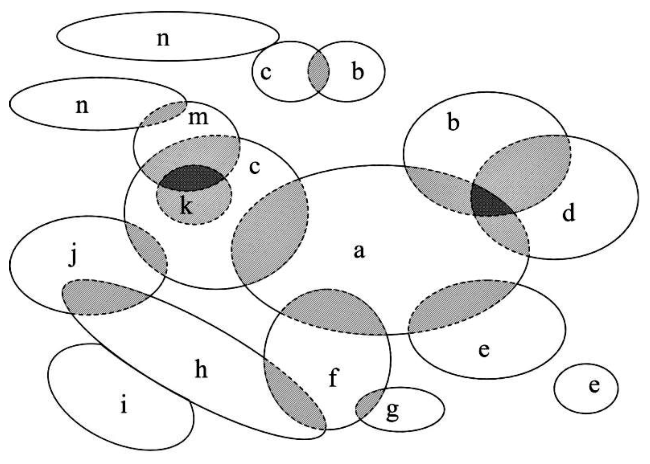
We considered a collection of protected areas with overlapping relationships and contiguous boundaries as a continuous area, in other words, the boundary region formed by a connected whole, which belonged to a collection of natural reserves with an overlapping or adjacent relationship; n represents the number of protected areas involved in continuous areas. The formula is as follows:
A c = 1 i n ( A 1 + A 2 + A n ) 1 i j n ( A i A j ) + 1 i j k n ( A i A j A k )
Ac represents the total calculated area of the continuous boundary areas, i.e., the projected area of the boundary range of a continuous region (the shaded area in Figure 2).
Ai is the area of the ith protected area.
The higher the number of overlaps and the larger the overlap area, the greater the overlap strength. To characterize the overlap strength of the continuous area, we quantified both the number and the area of overlaps. First, we found the intersection area with the most overlap in the continuous area and assigned the maximum intensity level of the overlap as Qn = n. Then, using the area of this overlap Ac, the overlap strength Oq = (Qn*On + Qn − 1*(On − 1 − On) + …… + Q1*(O1 − O2))/Ac. When all protected areas in the contiguous area completely overlap, Oq = n, and when none overlap, Oq = 0. The overlap intensity is generally located between 0 and n.

2.2.3. Selection of Candidate Areas for National Parks

(1)
Preliminary screening of Candidate areas for national parks
The Guideline on the Establishment of Protected Area System with National Park as the Main Body stipulated that the aim of national parks is to protect national representative natural ecosystems; national parks, nature reserves and nature parks were designed to provide comprehensive ecosystem service, support service and cultural service, respectively [46]. The guideline also required protected areas to be integrated while maintaining the same level of protection, with lower levels conforming to high levels of protection as needed [7]. Qualified protected areas should be given priority in the integration of national parks so that the comprehensive ecosystem service function, protection intensity, protection level and overlapping intensity should be considered in the initial selection process of national parks.
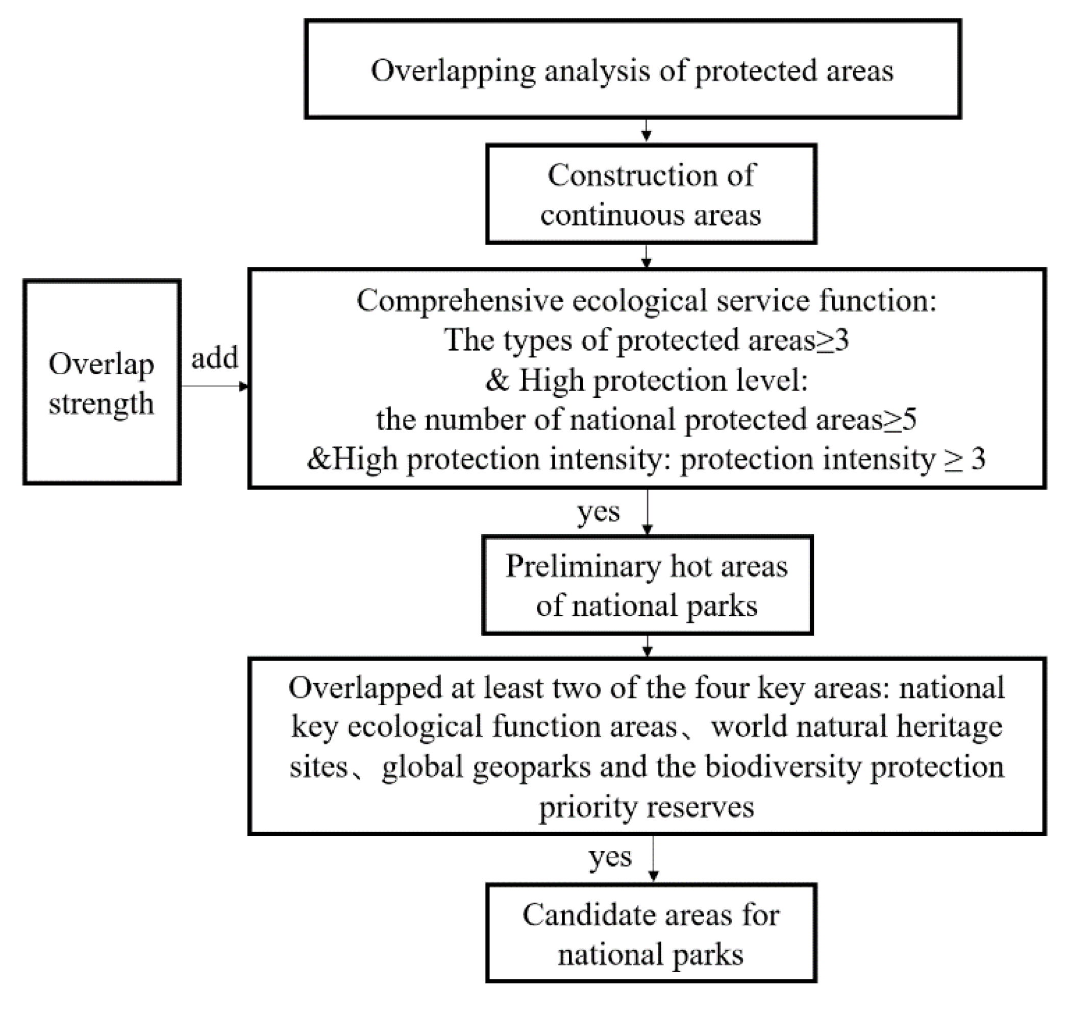
On these grounds, four parameters of the ecosystem service function type, protection level, protection intensity, and overlap strength were quantified separately for the continuous regions analyzed in this paper. To select preliminary candidate areas for national parks, we identified: (1) continuous areas with no less than three natural protection sites with comprehensive ecological system services; (2) continuous areas with no less than 5 national nature-protected lands (the protection level scale was national > provincial > city and county level); (3) the protection intensity scale was nature reserves > scenic areas > nature parks; therefore, combining protection level and intensity, national nature reserves had the most intense protection, which we assigned a score of 2; just under this would be national scenic areas and provincial nature reserves, which we assigned a score of 1, consistent with the protection intensity of the existing pilot national parks. When the combined strength value for a continuous area was at least 3, it was treated as a high intensity; (4) for continuous areas that meet preliminary screening conditions 1–3, overlap intensity was used to characterize its integration optimization complexity, prioritizing areas with high overlap complexity for future research and integration efforts (Figure 3).
(2)
Rescreening based on key areas
The Guideline on the Establishment of Protected Area System with National Park as the Main Body, issued in 2019, clearly stipulates that the national park is the most important and unique natural landscape in China’s natural ecosystems, the most natural heritage and the most abundant biodiversity, which corresponds to the role of China’s national key ecological function areas, world natural heritage sites, global geoparks and biodiversity protection priority reserves. Therefore, we used the four key areas listed above—global geoparks, world natural heritage sites, biodiversity protection priority reserves, and national key ecological function areas—to help prioritize the selection of preliminary national park sites. From the list of preliminary candidate areas generated above, we selected the continuous areas that overlap with at least two of these four key areas.

3. Results

3.1. Protected Areas Overlap Relationship

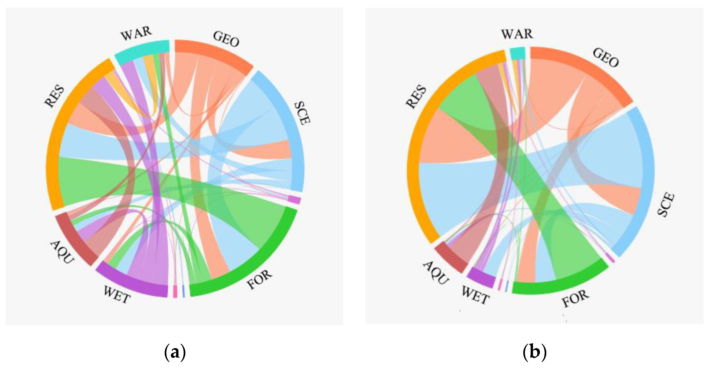
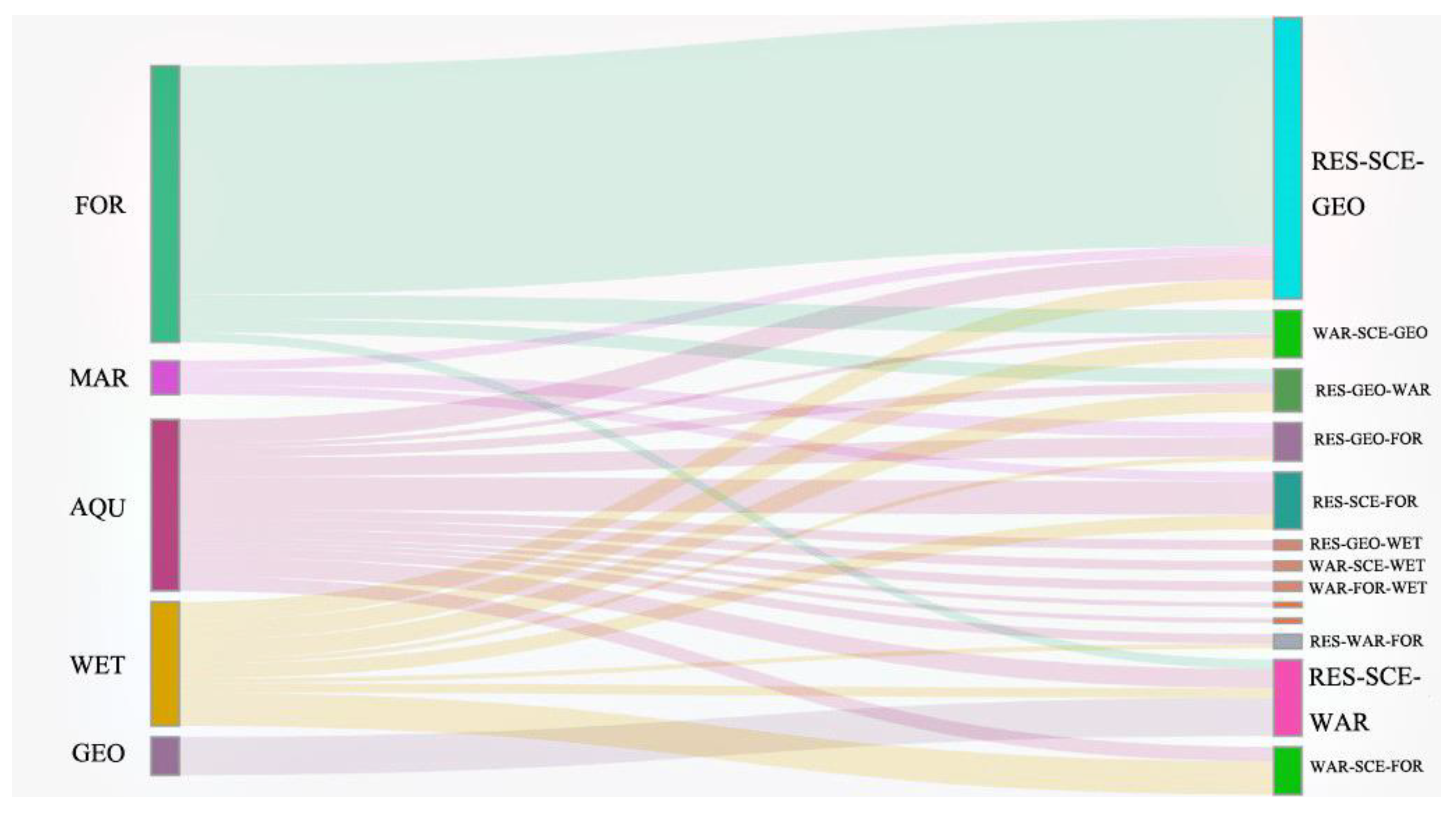
The analysis found 3659 pairs of overlapping protected areas. The highest number of overlaps occur in the pairing nature reserves–forest parks (549 groups), followed by scenic areas–forest parks (400), nature reserves–scenic areas (375), nature reserves–geological parks (258), nature reserves–aquatic germplasm reserves (222), forest parks–geological parks (217), and scenic areas–geological parks (210) (Table 2, Figure 4a). The three area types that overlapped most with other area types are nature reserves (1722 overlaps), forest parks (1417) and scenic areas (1326). The types with the fewest overlaps are marine parks, desert parks and desertification land closure reserves, with 62, 33 and 11 overlaps, respectively. This is mainly due to their relatively small number and greater specificity (e.g., single ecological type, special location) of these three types. In terms of overlap area, nature reserves and scenic areas have the largest overlap area, representing 24.2% of all two overlapping protected areas, followed by nature reserves–geological parks, 18.2%, and nature reserves–forest parks, 15.6% (Figure 4b).
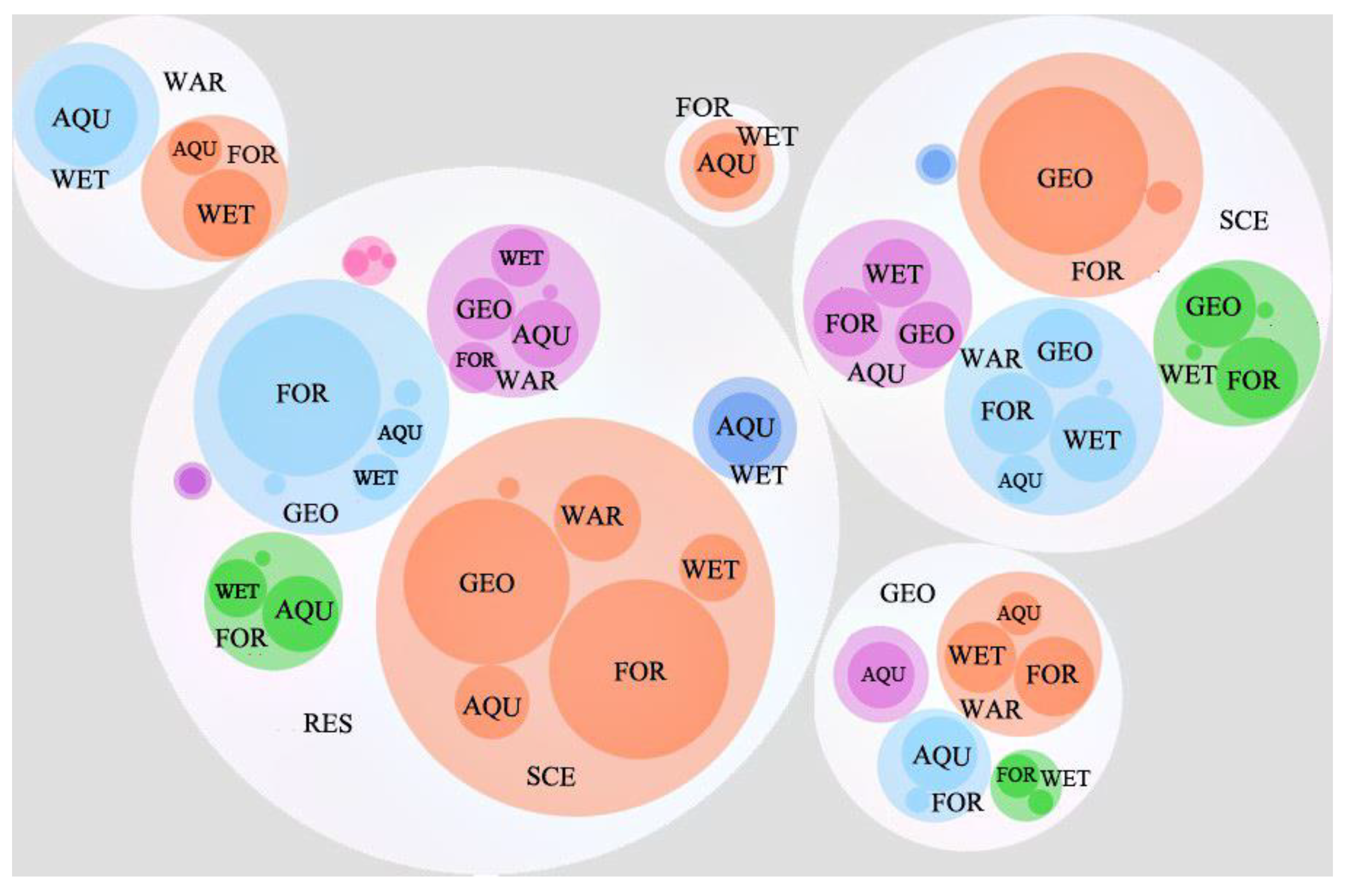
Double overlaps (i.e., overlaps occurring between three protected areas) were found to occur 970 times. Among them, the nature reserve–scenic area–forest park overlap group occur the most frequently (134), followed by nature reserve–scenic area–geological park (114), nature reserve–geological park–forest park (109), and scenic area–forest park–geological park (102) (Figure 5). In terms of overlap area, the scenic area-nature reserve-geological park grouping shows the most overlap, accounting for 33.8% of all double overlaps, followed by nature reserve–geological park–forest park, accounting for 23.3%.
There are 135 instances of overlaps between four different conservation sites, with most being nature reserve–scenic area–geological park–forest park overlaps (48 groups) (Figure 6).
In addition, there are 13 instances where 5 natural protected sites overlap one another, accounting for 0.19% of the total natural protected sites analyzed in this paper. These high overlap areas are distributed in Mount Tai, Tian Chi Lake and Wei Shan Lake and represent the maximum number of natural protected land overlaps in China.

3.2. Continuous Areas and Their Overlapping Features

(1)
Basic case of continuous area
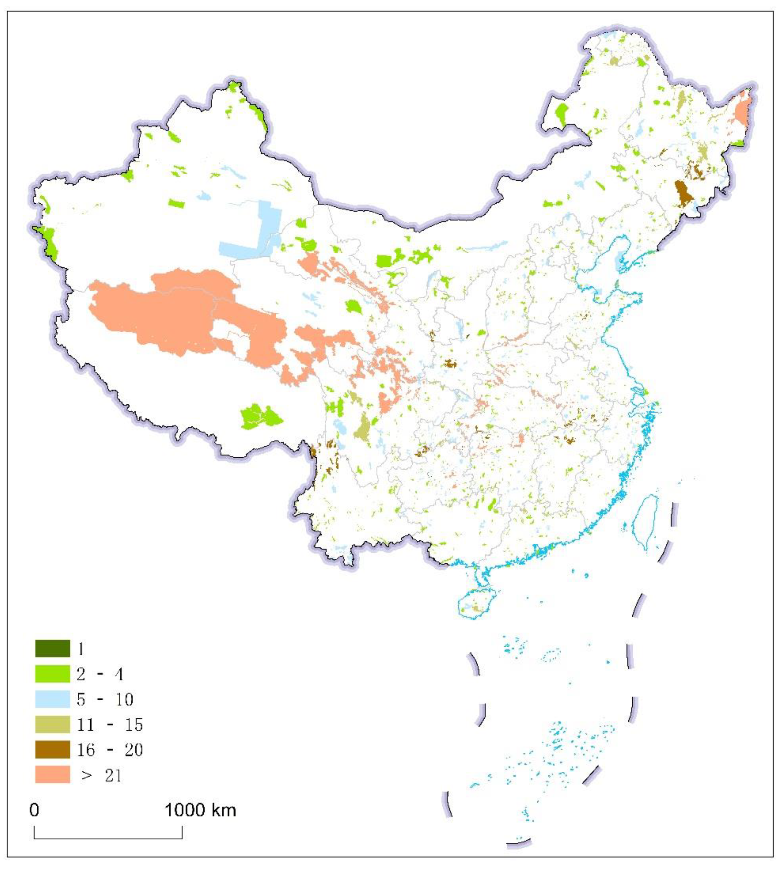
Using the analysis described above, continuous areas of adjacent and/or overlapping protected sites were obtained, resulting in a total of 1145 groups involving 4072 natural protected land sites. There were 556 groups with only two contiguous protected areas boundaries, accounting for 48.55% of the total number of continuous zones. There were 204 groups with three contiguous conservation land areas, representing 17.82% of the total continuous regions or 66.37% of all consecutive regions. The number of protected areas in groups of 5 or fewer accounted for 90% of the total number of protected areas studied in this paper, including 51 continuous zones consisting of more than 10 protected areas (Figure 7).
The aggregation and spatial distribution of continuous areas can be divided into the following two groups: ➀ Dot-like continuous—usually, these features consist of a focus center or a small range of overlap denoting an ecosystem or a protected object. The number of overlaps is generally small, but the overlap rate is higher on average. Some hills and lakes will form small continuous areas, such as Bagong Mountain, Hengshui Lake and other continuous areas. ➁ Continuous in strips—block continuous areas involve a large number of protected areas forming interprovincial and cross-regional continuity, such as Western Sichuan–Gannan and the Greater Xing’gan Mountains; strip continuous areas usually occur when protected areas cluster along large rivers and belt mountains, such as the downstream Songhua River and Daqingshan.
(2)
Continuous region overlapping features
Overlap characteristics of continuous areas can be divided into the following three groups: ➀ Number of overlaps—areas with high overlap numbers often form natural protective aggregation centers, and some continuous areas even form multi-aggregation centers. Such continuous areas are often the areas that are most complex and need to be integrated, such as Mount Tai. ➁ Overlapping coefficient—continuous areas with a high overlap rate tend to have a small total area, such as at Qinghai Lake and Xingkai Lake, with an overlap rate of more than 50% and areas of more than 1000 square kilometers. ➂ Overlap intensity—regions with a large overlap strength tend to be areas with high overlap numbers or high overlap rates, such as Cangshan Erhai Lake.
(3)
The spatial relationship between continuous areas and key areas
The national key ecological function areas play a primary role in maintaining the key areas of national ecological security. Global geoparks and world natural heritage sites have protected the most unique portions of China’s natural landscape and the most essential parts of China’s natural heritage. The biodiversity protection priority reserve is the region with the highest levels of biodiversity in China. The spatial relationship between these four important areas and the continuous areas is as follows:
➀ National Key Ecological Function Areas: 44% of protected areas are in five or more continuous areas that overlap with national key ecological function areas. The continuous areas with more than 10 protected areas overlap 63% with the national key ecological function areas.
➁ World Natural Heritage Sites: China has 14 world natural heritage sites and 4 that are both world, natural and cultural heritage sites, namely, Mount Taishan, Huangshan Mountain, the Leshan Giant Buddha of Mount Emei and Wuyi Mountain. Continuous areas overlap with the above world natural heritage sites, except for the Chengjiang Fossil World Natural Heritage Site. All other heritage sites overlap with continuous areas that contain a large number of natural protected sites.
➂ Global Geoparks: There are 41 global geoparks in China, with 39 continuous areas that overlap with them.
➃ Biodiversity Protection Priority Areas: Many continuous areas overlap strongly with the key areas of biodiversity protection priority areas, especially in continuous areas with a large number of protected areas, which are mostly distributed in the key areas of biodiversity conservation priority areas. Of the areas with five or more adjacent protected areas, 57% are located in or overlap with biodiversity protection priority reserves. Of the areas with more than 10 adjacent protected areas, 78% are located in or overlap with the biodiversity protection priority reserves. This includes 21 biodiversity protection priority reserves such as Qiangtang Sanjiangyuan, Taihang Mountain, Dabie Mountain, Qinling Mountains and Wuling Mountain.

3.3. Recommended Candidate Areas for National Parks in China

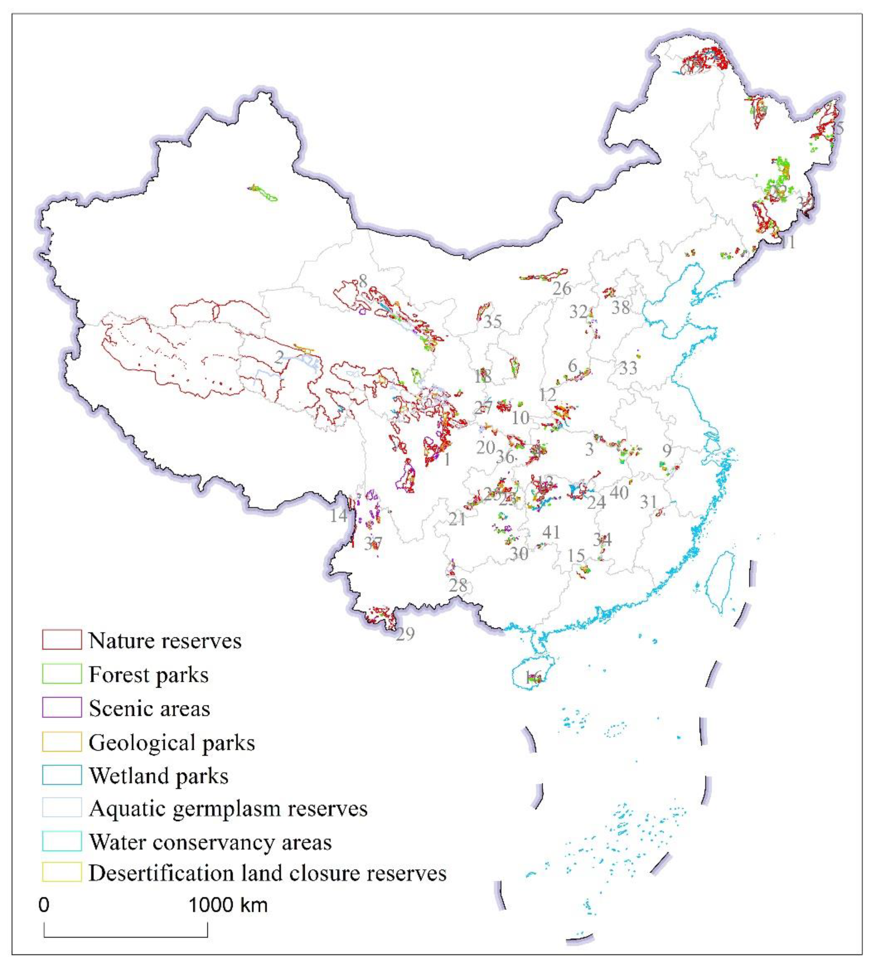
According to the national parks selection in Section 2.2.3, we identified a total of 41 continuous areas that could be used as the recommended candidate areas for national parks (Table 3, Figure 8), of which 9 continuous areas are essentially the same locations as the current pilot national parks. Table 3 shows the identified continuous areas. The proposed areas form a framework structure highly consistent with the national ecological strategy of “two screens, three belts”. The northeast forest belt includes the continuous areas of the Greater Hinggan Mountains, the Little Hinggan Mountains, Sanjiang Plain, the Northeast Tiger and Leopard, the Changbai Mountain and other continuous areas. The northern sand prevention belt includes Daqingshan, Helan Mountain, Qilian Mountain and other continuous areas. The southern hilly belt is surrounded by Dabie Mountain, Huangshan, Jinggangshan, Nanling, Nanshan, Miaoling, Wuling Mountain and other continuous areas. The ecological barrier belt of the Qinghai–Tibet Plateau includes the continuous area of the Sanjiangyuan, giant pandas and three rivers as the basic framework. The Loess Plateau–Sichuan–Yunnan ecological barrier is based on the Taihang Mountain, Liupan Mountain, Qinling Mountains, Daba Mountain, Jinfo Mountain and southwest Guinnan ecological barrier. The results demonstrate that the suggested national park areas selected by this method are reasonable, and can provide a reference for the integration and optimization of protected areas and the construction of national parks in China.

4. Discussion

4.1. Significance of the Study of Selection Strategy of National Parks Candidate Areas

The present system of protected areas has made critical contributions to the protection of biodiversity and important ecosystems in China. However, in the process of its establishment, there has been a general lack of systematic scientific design. The existence of overlap of different kinds of protected areas is very common in China.
The Guideline on the Establishment of Protected Area System with China National Park as the Main Body, issued in 2019, required that the national park to be established should not only have a large area and comprehensive functions, but also solve the problem of overlapping protected areas at present. As the primary means of ecosystem reform, the integration and optimization of protected natural areas is an important part of developing a protected natural area system centered around national parks, with scientific classification, a reasonable layout, strong protection and effective management. How to integrate and optimize protected areas is the most urgent and controversial issue in current conservation area reform. The integration and optimization of conservation efforts and establishment of national parks is a complex process requiring a combination of policy and scientific efforts.
Therefore, it is of great significance to study the candidate area for the selection of a national park. An increasing number of researchers are beginning to pay attention to this field. Research on the integration and optimization of protected areas in China has just started. However, most experts have put forward the method of integration and optimization approaches from the perspective of macro policies. Traditionally, most of the practical methods in China regarded protected areas as points for analyzing statistical data. Actually, the area and shape of the protected areas were different. These practical methods can better analyze the aggregation characteristics of protected areas, but the overall application is limited and the scientific validity is not strong.
Based on the analysis method of boundary overlap and the continuity of 10 types of protected areas, we proposed a reasonable and effective selection method of national parks candidate areas, considering overlapping and contiguous areas, which can not only reflect the aggregation area of China’s protected areas, but also reflect the aggregation degree of protected areas. The results show that 52.9% of the protected areas overlap and 1145 groups of contiguous protected areas form continuous boundary areas. According to the identified continuous areas, overlapping degree, protection levels and function, 41 candidate areas of national parks in China are proposed. This study is an important attempt among many scientific efforts. The characteristics of the protected areas were quantified by comprehensively considering the types of protected areas, overlapping times and overlapping areas, and the areas with a high conservation value were extracted, so as to grasp the main management conflicts and extract important areas. It can provide a scientific basis for determining the spatial layout of China’s new protected areas system and the establishment of national parks.

4.2. The Shortages of the Overlapping and Contiguous Areas Analysis Method

The integration and optimization of protected areas and establishment of national parks is a complex process requiring a combination of policy and scientific efforts that go beyond the consideration of overlap and contiguous areas. Ultimately, these efforts will need to combine top-down and bottom-up approaches, while further exploring scientific policies.
Due to the lack of boundaries in some national conservation sites at the time of this analysis, some individual national park candidate areas may be incorrectly eliminated from the process. In addition, offset, incomplete, or inaccurate digitization may lead to some errors in a few continuous areas.

5. Conclusions

Based on the overlap and connection of natural protected areas in China, the continuous area of protected areas in China is determined. On this basis, the preliminary candidate areas for national parks are proposed. Our results suggest that 52.9% of the protected areas in China overlap with one another. There are 1145 groups of contiguous protected areas that form continuous boundary areas, accounting for 58.9% of the total number of protected areas analyzed in this paper. According to the identified continuous areas, the overlapping degree, protection levels and function, 41 candidate areas of national parks in China are proposed. The proposed areas form a framework structure highly consistent with the national ecological strategy of “two screens, three belts” in China, of which nine continuous areas are essentially the same locations as the current pilot national parks. So, the recommended areas selected according to this research method are reasonable and can not only provide a scientific basis for determining the spatial layout of China’s national parks, but also inspire policy makers to make a systematic scientific design for a protected areas system in order to better protect biodiversity and important ecosystems in China.

Author Contributions

Conceptualization, X.L., J.G. and C.J.; data curation, C.W. and W.M.; formal analysis, X.L., J.G. and C.J.; methodology, J.Y., Y.W. and D.J.; software, C.J. and Y.W.; writing—original draf, X.L., J.G. and C.J.; writing—modify, X.L., Y.W. and C.J.; writing—editing, X.L. and J.G. All authors have read and agreed to the published version of the manuscript.

Funding

This research was funded by the Third Xinjiang Scientific Expedition Program (Grant No. 2021xjkk1402), the Strategic Priority Research Program of Chinese Academy of Sciences (Grant No. XDA28050200) and the Major Special Project-the China High-Resolution Earth Observation System (Grant No. 30-Y30F06-9003-20/22).

Acknowledgments

The authors would like to thank the editors and reviewers for their insights and comments that substantially improved this paper.

Conflicts of Interest

The authors declare no conflict of interest.

References

  1. Tang, F.L.; Lü, X.L.; Cai, F.; Sun, H.Y.; Luo, W.X. Reflections on integrated optimization schemes of protected areas. Landsc. Archit. 2020, 27, 8–13. [Google Scholar]
  2. Gao, J.X.; Liu, X.M.; Wang, C.; Wang, Y.; Fu, Z.; Hou, P.; Lü, N. Evaluating changes in ecological land and effect of protecting important ecological spaces in China. Acta Geogr. Sinica 2021, 76, 1708–1721. [Google Scholar] [CrossRef]
  3. Liu, X.M.; Fu, Z.; Wen, R.H.; Jin, C.P.; Wang, X.F.; Wang, C.; Xiao, R.L.; Hou, P. Characteristics of human activities and the spatio-temporal changes of national nature reserves in China. Geogr. Res. 2020, 39, 2391–2402. [Google Scholar]
  4. Gao, J.X.; Xu, M.J.; Zou, C.X. Development achievement of natural conservation in 70 years of new China. Chin. J. Environ. Manag. 2019, 11, 25–29. [Google Scholar]
  5. Zhu, C.Q. Perspective on development of national park system in China. Biodivers. Sci. 2014, 22, 418–420. [Google Scholar]
  6. Tang, F.L.; Wang, M.J.; Sun, H.Y. Reform path on management system of natural protected area. For. Constr. 2019, 1–5. [Google Scholar]
  7. General Office of the CPC Central Committee and General Office of the State Council of the PRC. The Guideline on the Establishment of Protected Area System with National Park as the Main Body. Available online: http://www.gov.cn/zhengce/2019-06/26/content_5403497.htm (accessed on 26 July 2019).
  8. Wang, M.J.; Sun, H.Y. Primary research on establishing protected area system dominated by national park. For. Constr. 2018, 1–5. [Google Scholar]
  9. Gao, J.X.; Liu, X.M.; Zhou, D.Q.; Ma, K.P.; Zhou, Q.; Li, G.Y. Some opinions on the integration and optimization of natural protected areas in China. Biodivers. Sci. 2021, 29, 290–294. [Google Scholar] [CrossRef]
  10. Papageorgiou, K.; Vogiatzakis, I.N. Nature protection in Greece: An appraisal of the factors shaping integrative conservation and policy effectiveness. Environ. Sci. Policy 2006, 9, 476–486. [Google Scholar] [CrossRef]
  11. Singh, S.; Sastry, A.R.K.; Mehta, R.; Uppai, V. Setting Biodiversity Conservation Priorities for India; World Wide Fund for Nature-India: New Delhi, India, 2000; pp. 680–690. [Google Scholar]
  12. Oldfield, T.E.E.; Smith, R.J.; Harrop, S.R.; Leader-Williams, N. A gap analysis of terrestrial protected areas in England and its implications for conservation policy. Biol. Conserv. 2004, 120, 303–309. [Google Scholar] [CrossRef]
  13. Pouzols, F.M.; Toivonen, T.; Minin, D.E.; Kukkala, A.S.; Kullberg, P.; Kuusterae, J.; Lehtomaeki, J.; Tenkanen, H.; Verburg, P.H.; Moilanen, A. Global protected area expansion is compromised by projected land-use and parochialism. Nature 2014, 516, 383–386. [Google Scholar] [CrossRef] [PubMed] [Green Version]
  14. Watson, J.E.M.; Dudley, N.; Segan, D.B.; Hockings, M. The performance and potential of protected areas. Nature 2014, 515, 67–73. [Google Scholar] [CrossRef] [PubMed]
  15. Jackie, Y.Y.; Richard, T.C.; David, D. A fine-scale gap analysis of the existing protected area system in Hong Kong, China. Biodivers. Conserv. 2004, 13, 943–957. [Google Scholar]
  16. Raphal, M.; Alain, T. Creation of a nature reserve, its effects on hunting management and waterfowl distribution in the Camargue (southern France). Biodivers. Conserv. 2002, 11, 509–519. [Google Scholar]
  17. Norman, M. Threatened biotas: “Hot spots” in tropical forests. Environmentalist 1988, 8, 187–208. [Google Scholar]
  18. Sankaran, R. Developing a protected area network in the Nicobar Islands: The perspective of endemic avifauna. Biodivers. Conserv. 1997, 6, 797–815. [Google Scholar] [CrossRef]
  19. Roger, K. Biodiversity, hotspots and defiance. Trends Ecol. Evol. 2000, 15, 484–485. [Google Scholar]
  20. Clark, F.S.; Slusher, R.B. Using spatial analysis to drive reserve design: A case study of a national wildlife refuge in Indiana and Illinoi s (USA). Landsc. Ecol. 2000, 15, 75–84. [Google Scholar] [CrossRef]
  21. Balmford, A. Conservation planning in the real world: South Africa shows the way. Trends Ecol. Evol. 2003, 18, 435–438. [Google Scholar] [CrossRef]
  22. Crowling, R.M.; Pressey, R.L.; Rouget, M.; Lombard, A.T. A conservation plan for a global biodiversity hotspot-the Cape Floristic Region, South Africa. Biol. Conserv. 2003, 112, 191–216. [Google Scholar] [CrossRef] [Green Version]
  23. Pierce, S.M.; Cowling, R.M. Systematic conservation planning products for land-use planning: Interpretation for implementation. Biol. Conserv. 2005, 125, 441–458. [Google Scholar] [CrossRef]
  24. Tang, X.P.; Jiang, Y.F.; Liu, Z.L.; Chen, J.Z.; Liang, B.K. Top-level design of the natural protected area system in China. For. Resour. Manag. 2019, 26, 1–7. [Google Scholar]
  25. Ouyang, Z.Y.; Xu, W.H. Integrating nature protection system and establishing national parks under legislation. Biodivers. Sci. 2014, 22, 425–426. [Google Scholar]
  26. Yu, H.; Zhong, L.S. Discussion on the selection criteria of national parks in China based on international. Acta Ecologica Sinica 2019, 39, 1309–1317. [Google Scholar]
  27. Wang, M.J.; Tang, F.L.; Sun, H.Y.; Zhang, G.X.; Yin, Z.J.; Zhang, T.X.; Yang, W.J. Preliminary exploration on the general layout of national parks in China. For. Constr. 2017, 2017, 7–16. [Google Scholar]
  28. Liu, G.M.; Yang, X.Z.; Lin, Y.; Tian, D. The spatial concentration characteristics and the rule analysis on the national forest park in China. Ecol. Econ. 2010, 131–134. [Google Scholar]
  29. Guo, Z.L.; Zhang, M.Y.; Cui, L.J.; Wang, D.A.; Wang, H.N.; Du, X. Establishment and dynamics of national wetland park system in China. Chin. J. Ecol. 2019, 38, 532–540. [Google Scholar]
  30. Pan, J.H.; Zhang, J.H. Spatial distribution characteristics and accessibility of national wetland parks in China. Chin. J. Ecol. 2014, 33, 1359–1367. [Google Scholar]
  31. Wu, J.Y. Study on spatial distribution characteristics of Chinese national parks. Geogr. Res. 2014, 33, 1747–1757. [Google Scholar]
  32. He, X.Q.; Wang, X.W.; Xiong, G.B.; Liu, Y. Study on the spatial distribution and its evolution of national geoparks in China. Areal Res. Dev. 2014, 33, 86–91. [Google Scholar]
  33. Sheng, Q.; Ru, H.J.; Li, Y.F.; Ni, Z.H. The distribution pattern of national aquatic germplasm reserves in China. J. Fish. China 2019, 43, 62–80. [Google Scholar]
  34. He, X.Q.; Wang, X.W. Spatial distribution of national mine parks of China. Sci. Technol. Manag. Land Resour. 2014, 31, 50–56. [Google Scholar]
  35. Qiu, P.; Zhang, R.J. On the influential factors and spatial distribution of national water parks’ in China-analysis based on the spatial-dependent model and the fix-effects model. J. Stat. Inf. 2009, 24, 47–53. [Google Scholar]
  36. Fu, L.Q.; Zong, C.; Kong, S.; Ma, J.Z. The spatial distribution of national protected areas and national scenic areas and ecotourism potential analysis. Chin. J. Wildl. 2015, 36, 218–223. [Google Scholar]
  37. Kong, S.; Zeng, D.; Yang, Y.B.; Ma, J.Z. Spatial differences comparison between national protected areas and national forest park. J. Northeast. Agric. Univ. 2013, 44, 56–61. [Google Scholar]
  38. Jiang, C.; Ma, S.G.; Wang, Q.S.; Kong, S.; Ma, X.; Zong, C. Spatial distrbuyion pattern of five major categories of protected area in China. Chin. J. Wildl. 2016, 37, 61–66. [Google Scholar]
  39. Zhou, J.; Zhang, J.H.; Chen, J.; Li, M. Analysis of spatial structure on wetland protected areas, wetland parks and international important wetlands in China. Wetl. Sci. 2014, 12, 597–605. [Google Scholar]
  40. Fan, H.L.; Wang, F. Similarities and differences in spatial distribution and its influencing factors of two kinds of national wetland parks in China. Acta Sci. Nat. Univ. Pekin. 2016, 52, 535–544. [Google Scholar]
  41. Ma, K.; Tang, X.L.; Liu, S.Y.; Wang, Y.W.; Ren, Y.J.; Liu, X.H. Study on spatial distribution characteristics of national protected areas and the space strategy of national park corridor in the Yangtze River basin. Resour. Environ. Yangtze Basin 2018, 27, 2053–2069. [Google Scholar]
  42. Chen, B.; Zhu, Y.P.; Lou, J.W.; Ji, Y.C.; Xin, L.J.; Wang, W. Relationships between national protected areas and other types of protected areas in Yunnan province. Ecol. Econ. 2015, 31, 129–135. [Google Scholar]
  43. Jin, Y.; Zhou, X.; Shu, L.R. A Study on the integration and boundary adjustment of Chinese national landscape resorts. Planners 2019, 35, 50–55. [Google Scholar]
  44. Yang, Z.; Cheng, K.; Fu, L.Q.; Zong, C.; Ma, J.Z. Spatial overlapping analysis for protected areas, forest parks and wetland parks in forestry management system of Northeast China. Chin. J. Ecol. 2017, 36, 3305–3310. [Google Scholar]
  45. Jin, C.P.; Liu, X.M.; Wang, X.F.; Sun, Y.Y.; Fu, Z.; Wang, C.; Hou, J. Overlapping relationship of the protected area boundary in the Yangtze River economic beltand its integration countermeasures. Acta Ecol. Sinica 2020, 40, 7323–7334. [Google Scholar]
  46. Lü, C.; Zeng, Q.; Lei, G.C. Ecosystem service-based protected area category system. Chin. Landsc. Archit. 2017, 33, 19–23. [Google Scholar]
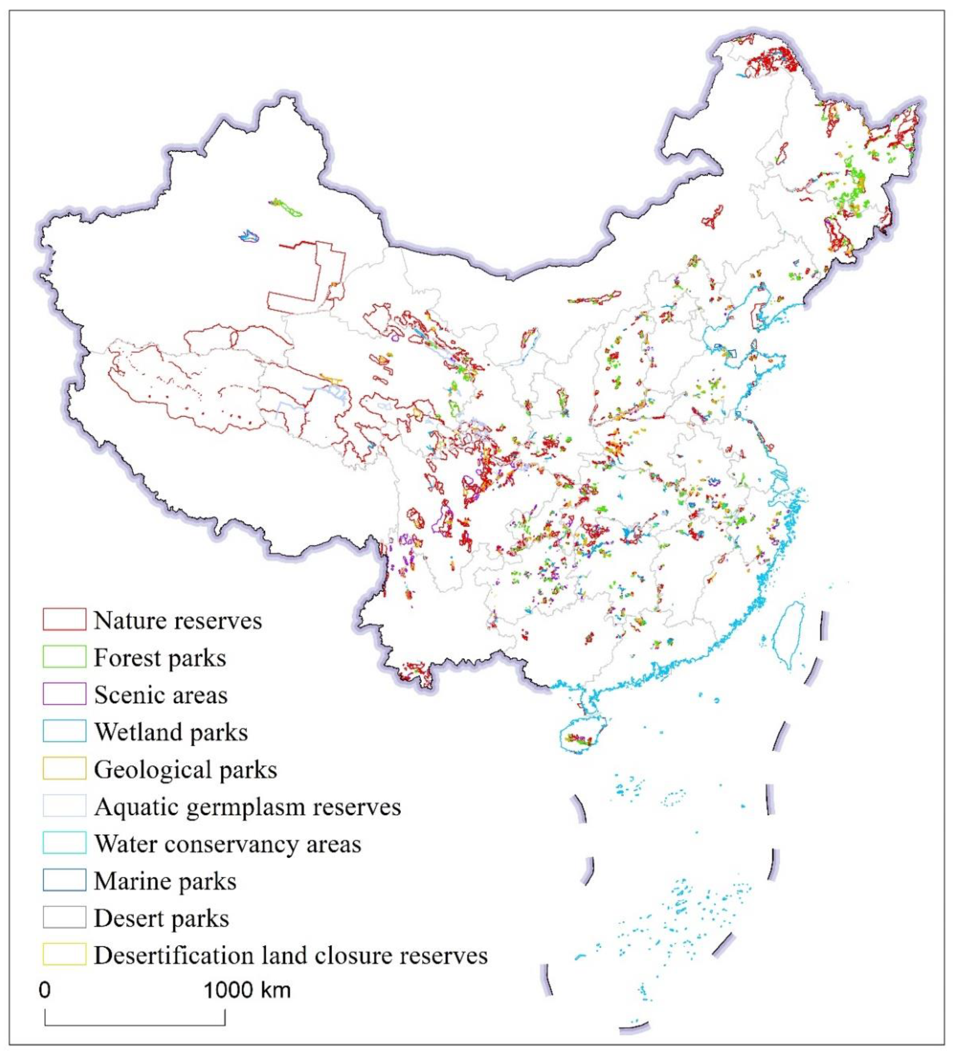
Figure 1. Spatial distribution map of protected areas in China.
Sustainability 14 02578 g001
Figure 2. Construction of continuous area of protected areas. In the figure, a–n represents the boundary of protected area a, b, c……n.
Sustainability 14 02578 g002
Figure 3. Selection map of commended candidate areas for national parks.
Sustainability 14 02578 g003
Figure 4. Chord diagram showing overlapping relationships between two different types of protected areas. Line width denotes (a) the number of overlaps, and (b) the total overlapping area of overlaps between protected areas. (Abbreviations: nature reserves (RES), geological parks (GEO), scenic areas (SCE), forest parks (FOR), wetland parks (WET), aquatic germplasm reserves (AQU), and water conservancy areas (WAR). Marine parks, desert parks and desertification land closure reserves are not marked in the figure due to small overlap.)
Sustainability 14 02578 g004
Figure 5. Diagram showing overlaps between three different protected areas. (Abbreviations: nature reserves (RES), geological parks (GEO), scenic areas (SCE), forest parks (FOR), wetland parks (WET), aquatic germplasm reserves (AQU) and water conservancy areas (WAR). Marine parks, desert parks and desertification land closure reserves are not marked in the figure due to small overlap.)
Sustainability 14 02578 g005
Figure 6. Four overlapping relationship maps of different types of different protected areas. (Abbreviations: nature reserves (RES), geological parks (GEO), scenic areas (SCE), forest parks (FOR), wetland parks (WET), aquatic germplasm reserves (AQU), marine parks (MAR) and water conservancy areas (WAR). Desert parks and desertification land closure reserves are not marked in the figure due to small overlap.)
Sustainability 14 02578 g006
Figure 7. Map of continuous areas color-coded by the number of protected areas they contain.
Sustainability 14 02578 g007
Figure 8. Distribution of recommended candidate areas for national parks in China.
Sustainability 14 02578 g008
Table 1. The number and area of various types of protected areas.
TypeNumberArea (km2)
Geological park39746,811.86
Scenic area812107,277.16
Marine park6013,768.61
Forest park164779,634.96
Desertification land closure reserve172415.93
Desert park802846.32
Wetland park124932,660.69
Aquatic germplasm reserves 51446,074.18
Water conservancy area6266361.48
Nature reserves15121,383,398.12
Total69141,721,249.31
Table 2. Number of overlaps between different types of protected areas.
TypeGeological ParkScenic AreaMarine ParkForest ParkDesertification Land Closure ReserveDesert ParkWetland ParkAquatic Germplasm ReserveWater Conservancy AreaNature Reserve
Geological park-210621702513547258
Scenic area210-144001313474115375
Marine park614-700510119
Forest park2174007-051056173549
Desertification land closure reserve0100-30115
Desert park23053-40313
Wetland park51134510504-141149173
Aquatic germplasm reserve3574106110141-59222
Water conservancy area471151731314959-108
Nature reserve25837519549513173222108-
Table 3. List of recommended candidate areas for national parks.
Suggested AreaNational NumberNumber of Protected Area TypesProtection StrengthOverlapping IntensityMain Overlapping Areas and NamesRepresentative National Nature Protected Land
Panda *437460.15ST: Sichuan–Yunnan forest; SZ: Jiuzhaigou, Huanglong, giant panda habitat; SW: Minshan–Hengduan Mountain areaN (Jiuzhaigou, Tangjiahe, Wolong, etc.), S (Siguniang Mountain, Jiuzhaigou-Huanglong Temple, etc.), and G (Huanglong, etc.)
Three river source region *23812<0.01ST: Source of the Yangtze River, Yellow River Source, Algin; SZ: Hoh Xil; SD: Kunlun Mountain; SW: Qiang Tang SanjiangyuanN (Sanjiangyuan, Hoh Xil, Qiangtang, etc.), G (Qinghai Maqin, Animqing, etc.), W (Yushu Batang, etc.) A (Gequ River, etc.)
Dabie Mountain317200.73ST: Dabie Mountain, source of Huaihe River; SD: Dabie Mountain; SW: Dabie MountainN (Dabie Mountain, Liankang Mountain, Jinzhai Tianma, etc.), G (Dabie Mountain, etc.), F (Huangbai Mountain, etc.), W (Paradise Lake, etc.), A (Ten Thousand Buddha Lake, etc.), C (Foziling, etc.)
Shennongjia-The Three Gorges *206220.53ST: The Three Gorges Reservoir Area, the South-to-North Water Diversion Project; SZ: Shennongjia; SD: Shennongjia; SW: Daba MountainN (Shennongjia, Dajiu Lake) W (Badong Golden silk monkey, etc.), S (Yangtze Three Gorges, etc.), G (sinkhole seam, etc.), W (Dajiu Lake), F (Shennongjia, Yichang Longmen River, etc.)
Three River Plain225220.11ST: Sanjiang Plain Wetland; SW: Sanjiang Plain DistrictN (Sanjiang, Dali River, Pauli River, Northeast Black Bee, Treasure Island, etc.), F (Wandashan, etc.), and W (Raohe Uzuli River, etc.)
South Taihang Mountain186120.52SD: Wangwu Mountain-Dai Meishan, Yuntai Mountain; SW: Taihang Mountain areaN (Alexandria, Taihang Mountain macaque, Yangcheng Mang Macaque), S (Yuntai Mountain), G (Wangwu Mountain, Lingchuan Wangmang Mountain), F (Yuntai Mountain, etc.), W (Dan River, Zezhou)
Wuling Mountain217100.59ST: Wuling Mountain Mountain; SW: Wuling Mountain DistrictN (Gaowangjie, Borrowing Mother Creek), S (Mengdong River, Dehang), G (Hunan Ancient Zhang Red Stone Forest), F (Xiaozhai, Sitting Long Gorge, etc.), W (Wuqiang Creek, etc.)
Qilian Mountain *14780.23ST: The Black River Basin; SW: The Qilian MountainsN (Gansu Qilian Mountain, Liancheng, Yanchi Bay), G (Zhangye, etc.), F (Beishan, Qinghai, etc.), W (Qilian Black Heyuan), C (Daynokou Reservoir)
Mount Huang12790.78ST: Water conservation in the upper reaches of the Xin’an River; SZ: Huangshan; SD: Huangshan; SW: Huangshan–Huaiyu DistrictN (Anhui Qingliang Peak, etc.), S (Huangshan, Longchuan, Huashan Mystery Cave-gradual River), G (Anhui Huangshan), F (Huizhou, Huangshan), W (Taiping Lake)
Qinling Mountains134180.02ST: Qinba biodiversity; SW: the middle section of the Qinling MountainsN (Taibai Mountain, Foping, Huangbai Plateau, Old County, etc.), F (Shaanxi Heihe, Taibai Mountain)
Paekdusan156110.09ST: Changbai Mountain Forest; SW; West section of Changbai MountainN (Changbai Mountain, Ji’an, Songhua River Three Lakes, Tonghua Shihu), S (Songhua Lake), G (Jingyu Volcano, Fusong), F (Jilin Shihu, Wunu Peak, Quan Yangquan)
The Funiu Mountians12690.27ST: Water source area of the middle route of the South-to-North Water Diversion Project; SD: Funiu Mountain;SW: Qinling DistrictN (Funiu Mountain, Baotianman, Nanyang Dinosaur Egg Fossil Group, etc.), G (Funiu Mountain, Baotian Man, etc.), F (Baiyun Mountain, etc.), C (Shimen Lake, Xixia County)
Zhangjiajie8570.30ST: Wuling Mountain District; SZ: Wulingyuan; SD: Zhangjiajie; SW: Wuling Mountain DistrictN (Eight Dagong Mountain, Seven Sister Mountain, Zhangjiajie Giant Salamander), S (Wulingyuan), F (Zhangjiajie, Tianmen Mountain), and C (Zhangjiajie Loujiang)
Three rivers and flows *8790.29ST: Northwest Yunnan; SZ: parallel current of three rivers; SW: South section of Hengduan MountainN (Galigong Mountain), S (Yulong Snow Mountain, Three Rivers), G (Yunnan Yulong Snow Mountain Glacier, Lijiang Laojun Mountain), F (Yunnan Feilai Temple), W (Qinghuadian)
Nanling Mountains9760.72ST: Nanling; SZ: Danxia, China; SW: NanlingN (Nanling, Mangshan), G (Guangdong Yangshan), F (Jiulong River), and W (Nanshui Lake)
Wuzhishan *83140.53ST: Central Hainan Island; SW: South-central Hainan IslandN (Wuzhishan, Hangluo Mountain, Yingge Ling), F (Hainan Qixian Ling, Hangluo Mountain)
Xiao Hinggan Mountains107130.43ST: Small Hinganling Forest; SW: lesser Khinganling DistrictN (Cuibei Wetland), S (Dazhu River), F (Dazhan River, etc.), and W (Hoji River)
Liupan Mountains9670.58ST: Loess Plateau; SW: Liupan Mountain Meridian RidgeN (Liupan Mountain), S (Kongtong Mountain), G (Kongtong Mountain Danxia), F (Liupan Mountain, etc.)
Da Hinggan Mountains8380.04ST: Greater Hinggan Mountains Forest; SW: Greater Hinggan Mountains DistrictN (Chona River, Greater Khinggan Mountains Khan Horse, Huzhong), W (Huma River Source)
Micang Mountain7470.96ST: Qinba biodiversity; SD: Guangwu Mountain–Nuoshui River; SW: Daba MountainN (Micang Mountain), S (Guangwu Mountain-Nuoshui River, Micang Mountain), G (Guangwu Mountain-Nuoshui River), A (Jiaojiahe Chongcleavage fish)
The downstream of the Chishui River94100.95SZ: Danxia, China; SW: Wuling Mountain DistrictN (Chishui tree-fern), S (Simianshan), G (Chishui Danxia), F (Xishui)
Mirror Park Lake–Great Tiger Mountain196100.49ST: Changbai Mountain Forest; SD: Jingpo Lake; SW: Changbai Mountain DistrictN (Yanming Lake, Beihu Lake), S (Jingpo Lake), G (Jingpo Lake), F (Heilongjiang Craa, Xuexiang, etc.), W (source of Jingpo Lake), A (Wave River)
Middle and lower reaches of Wujiang River12790.42ST: Wuling Mountain District; SW: Wuling Mountain DistrictN (Mayang River), S (Wujiang Mountain Gorge), G (Youyang), F (Qianjiang)
The Dongting Lake20590.08ST: New; SW: Dongting Lake DistrictN (East and West Dongting Lake, etc.), S (Yueyang Tower–Dongting Lake), W (Miluo River, etc.)
Jin Foshan126100.99SZ: karst, South China; SW: Wuling Mountain DistrictN (Jinfo Mountain, Dasha River), S (Jinfo Mountain), G (Wansheng), F (Montenegro)
Great Castle Peak7450.15ST: Grassland at the northern foot of Yinshan Mountain; SW: West Ordos–Helan Mountain–Yinshan MountainN (Inner Mongolia Daqingshan), F (Wula Mountain, Chilechuan, Wu dangzhao, etc.), W (Kunduron River), C (Hasuhai)
Xiaolongshan7650.01ST: Qinba biodiversity; SW: Qinling MountainsN (Xiaolong Mountain, Zibai Mountain), F (Zibai Mountain, Wulong Cave), W (Fengxian County Jialing River)
Southwest Guizhou6540.07ST: Stone desertification control of karst in Yunnan and Guizhou; SW: Limestone area of western GuizhouN (Jinzhong Mountain Black-tailed Pheasant), S (Maling River Canyon), G (Xingyi)
Xishuangbanna6450.10ST: Sichuan–Yunnan forest; SW: Xishuangbanna DistrictN (Xishuangbanna, Nadal River Basin), S (Xishuangbanna), F (Xishuangbanna)
Miaoling Mountains9730.14ST: Prevention and control of rocky desertification in karst, Guizhou, Yunnan; SZ: karst, South China; SW: NanlingN (Leigong Mountain), S (Wuyang River), G (Miaoling, Qiandongnan), F (Leigong Mountain, Taijiang, etc.), and W (Wengyou River)
Mount Wuyi *5450.002SZ: Wuyi Mountain; SW: Wuyi Mountain DistrictN (Fujian Wuyi Mountain, Jiangxi Wuyi Mountain), S (Wuyi Mountain), F (glossy Wuyi Mountain)
Camel Beam9650.76ST: new added; SW: Middle section of Taihang Mountain areaN (Camel Liang), S (Xibaipo-Tiangui Mountain), G (Fuping Tiansheng Bridge), F (Pingshan Camel Liang, Wuyue Village, Tiansheng Bridge), A (Zhongshan Lake, and Po Lake)
Mount Taishan6533.61ST: New; SZ: Mount TaiS (Taishan, Qianfoshan), G (Taishan), F (Taishan, Pharmaceutical Township)
Jinggangshan84100.39ST: Nanling Mountain; SW: NanlingN (Nanfeng Face, Qiyun Mountain), S (Jinggangshan), F (Shennong Valley, Qiyun Mountain)
The Helan Mountains5450.14ST: New added; SW: West Ordos-Helan Mountain–Yin MountainN (Inner Mongolia Helan Mountain, Ningxia Helan Mountain), S (Xixia Mausoleum), F (Sukou)
Daba Mountain9670.31ST: Qinba biodiversity; SW: Middle section of Daba MountainN (Daba ashan, Xueaoshan), F (Hongchi Dam), W (Qianstorey River, Zhenpingshu Heyuan)
Cangshan Erhai Lake6632.89ST: Sichuan and Yunnan; SD: Cangshan; SW: South section of Hengduan MountainN (Cangshan Lake and Erhai Lake), S (Dali Lake), G (Dali Lake and Cangshan Lake), and W (Eryuan West Lake Lake)
West Beijing5480.34SD: Fangshan; SW: Taihang Mountain DistrictN (Baihua Mountain, Little Wutai Mountain), S (Wild Sanpo), F (Wild Sanpo, Xiaolongmen)
Northeast Tiger Leopard *6370.004ST: Changbai Mountain Forest; SW: Changbai Mountain DistrictN (Hunchun Siberian Tiger, Sailing Northeast Tiger), S (Anti–Sichuan), A (Hunchun River)
Lushan Mountain6430.26SD: Lushan Mountain; SW: Poyang Lake DistrictN, S, G(Lushan), F (Lushan Mountain Shannan, Mazu Mountain, smallpox Well)
Nam Son *5430.11ST: Nanling Mountain; SW: NanlingB (Jintong Mountain), S (Nanshan), F (Liangjiang Canyon), W (Chengbu Baiyun Lake)
* Approximate agreement with the current pilot national park location and region. ST denotes national key ecological function areas, SZ denotes World Natural Heritage sites, SD denotes Global Geopark, SW denotes biodiversity protection priority reserves, and new refers to new national key ecological function areas. N indicates nature reserves, S indicates scenic areas, G indicates geological parks, F indicates forest parks, W indicates wetland parks, A indicates aquatic germplasm reserves, and C indicates water conservancy areas.
Publisher’s Note: MDPI stays neutral with regard to jurisdictional claims in published maps and institutional affiliations.