1. Introduction
Ecosystem services (ES) are defined as the benefits people derive from ecosystems [
1]. ES supply refers to the services that the ecosystem can provide for human society [
2]. ES demand are the services that humans obtain from the ecosystem for survival and development [
3]. The research on supply and demand of ecosystem services is an important foundation for optimizing regional ecosystem structure, and has important practical significance for realizing sustainable economic and social development [
4]. Land use/land cover (LULC) is one of the important influencing factors of ES as the changes have complex impacts on ecosystem patterns and processes for ES assessment [
5]. Regional land use change can significantly change the ecosystem patterns and processes, resulting in changes of ecosystem services supplies [
6]. LULC is a direct consequence of human and nature interactions [
7], the focus of research includes the global scale [
1,
8], national scale [
9], regional scale [
10,
11,
12], metropolitan areas [
13] and ecologically fragile areas such as wetlands [
14], river basins [
15] and mining areas [
16]. The Beijing-Tianjin-Hebei region is the political and economic center of China and is one of the most developed regions in China. For this specific area, some studies analyzed the eco-environmental effects [
17], ecological security pattern construction [
18], carbon sequestration [
19], and ecosystem services value [
20] based on LULC, research on the relationship between LULC and ES supply and demand is relatively lacking. Thus, it is necessary to explore the comprehensive impact of human activities on ES supply and demand from the land use change perspective in the Beijing-Tianjin-Hebei region.
To date, the primary methods to assess the supply and demand of ES are the Ecosystem Supply and demand index method [
21], the ecological model method [
22,
23], valuation method and participation method [
24,
25]. Burkhard first proposed the expert assessment matrix method for ES [
26] and applied it to assess the supply and demand of irrigated rice system services in Vietnam and the Philippines. Burkhard suggested that increasing the number of respondents and adopting data integration methods could improve the accuracy of results [
27]. This method is easy to operate and has low data requirements. It calculates regional ES through expert scores (0 to 5 points) representing matrix service supply and demand, so as to facilitate the comparison of the supply and demand of ES between regions. Based on the ES matrix approach, Md Shawkat Islam Sohel addressed the biophysical assessment of ES supply capacities of various land use/land cover (LULC) types in the Lawachara National Park and its surrounding areas in north-east Bangladesh [
28]. Weyland used an expert assessment matrix method to assess the relationship between ecosystem functions and services in four different eco regions of southern South America [
29]. Depellegrin used the ES matrix approach for the assessment of ES potentials and ES interactions over Lithuania’s national territory [
30]. Wangai applied the ES matrix approach to spatially display the potential for regulating ES in a data-scarce peri-urban region in Kenya [
31]. In China, some research improved the expert scoring matrix according [
32,
33]. This study of the supply and demand of ES included the Lake River basin, the Beijing-Tianjin-Hebei region, and the Yangtze River Delta region. The expert scoring matrix method for ES is mainly based on LULC, which requires less data, is easy to operate, and is suitable for research at various scales.
Research on the supply and demand of regional ES is based on the existing land use data. How will the supply and demand pattern change in the future? To date, research on this problem is still rare. However, the related research results of land use change simulation and prediction are rich. Several simulation models are widely used, such as CA(cellular automation), the Markov model [
34,
35], LUCAS (land use and carbon scenario simulator) [
36], SLEUTH (Slope, Land use, Excluded, Urban, Transportation, Hill shade) [
37], ANN-CA (artificial neural network-cellular automata) [
38], Geomod [
39], and CLUE-S (Conversion of Land Use and its Effects at Small Region extent) [
40], among which CLUE-S does not just integrate the regional natural and human elements, and improve the future land use/land cover change simulation research, but at the same time it can also comprehensively simulate the temporal and spatial changes of multiple land use types in different scenarios, providing a more scientific basis for land use decision-making. The CLUE-S model was invented by the Dutch Wach University of Ningen (formerly Wageningen Agricultural University). Studies by many scholars showed that the CLUE-S model has become an effective scientific tool for simulating changes in land use patterns in the future. Verburg used the CLUE-S model to analyze natural causes in the Philippines and Malaysia [
40]. In the CLUE-S modeling framework, Batisania parameterized and validated the model based on land use data interpreted from Landsat TM images of Centre County in 1993 and 2000 to predict the size of metropolitan areas in the United States [
41]. Trisura coupled the CLUE-S model and Evaluation model framework (GLOBIO) to assess biodiversity integrity, simulate land use patterns in northern Thailand in 2050, and analyze the impact of various development directions on biodiversity [
42]. Therefore, we can use the CLUE-S model to study the simulation and prediction of land use change in different scenarios, and on this basis, use the ecosystem service matrix to analyze the supply and demand pattern of ES based on future land use changes in different scenarios.
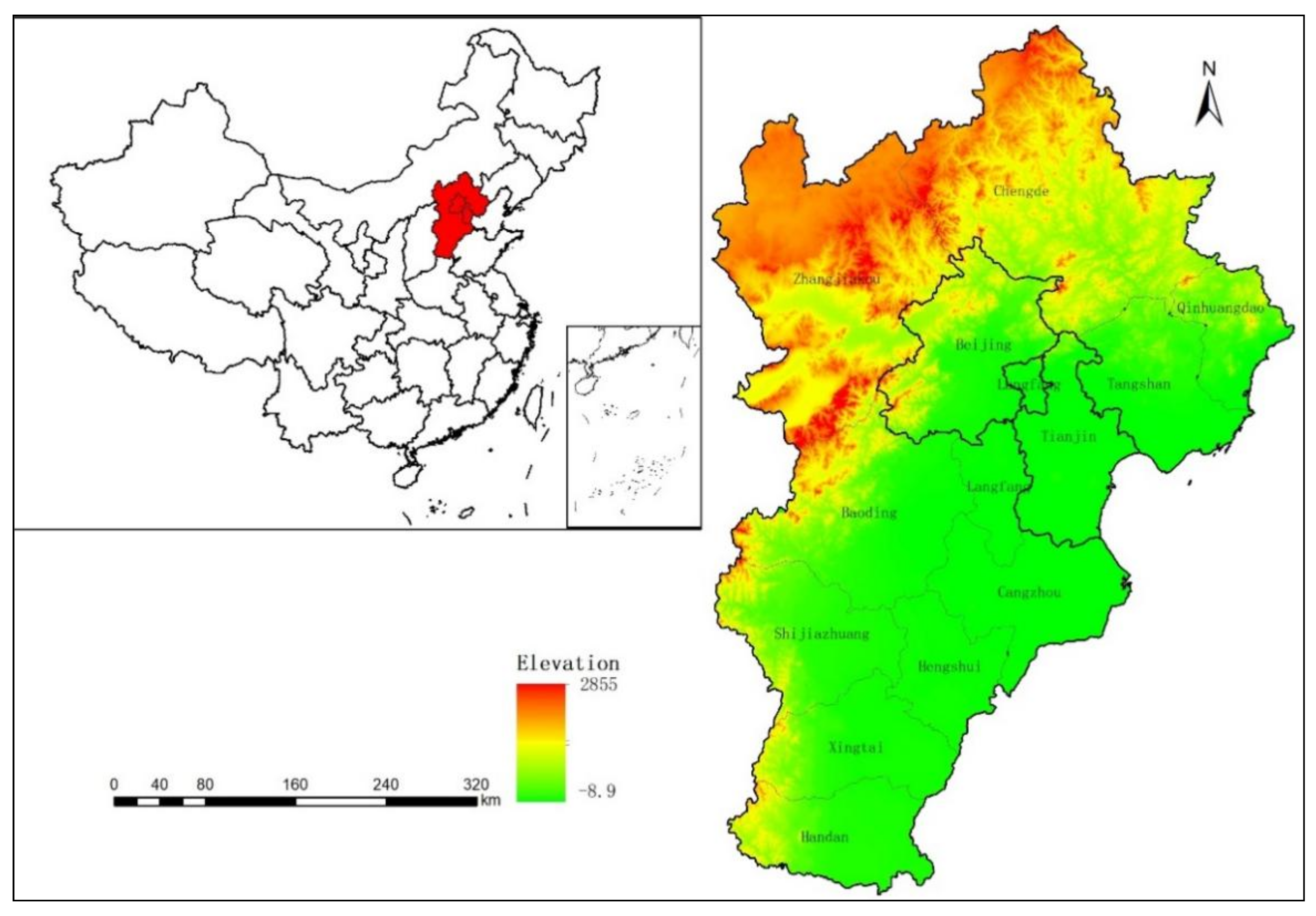
The Beijing-Tianjin-Hebei region is one of the most developed regions in China. The rapid expansion of its urban agglomerations has to a certain extent caused damage to the ecological environment. At present, the contradiction between the two has become particularly acute. With the growth of the population in Beijing and the development of heavy industry in the Tianjin and Hebei areas, severe ecological and environmental problems such as land subsidence, desertification, and sandstorms are becoming more and more serious [
21]. In this study, we analyzed the land use change patterns in the Beijing-Tianjin-Hebei region from 1990 to 2020; then, we used the Conversion of Land Use and Its Effects-Simulation (CLUE-S) model to simulate future land use patterns in the Beijing-Tianjin-Hebei region in multiple scenarios. The change in the ecosystem service (ES) supply and demand pattern from 1990 to 2050 was studied using ArcGIS and the expert assessment matrix. The results of this study can provide scientific data support for regional development.
4. Discussion
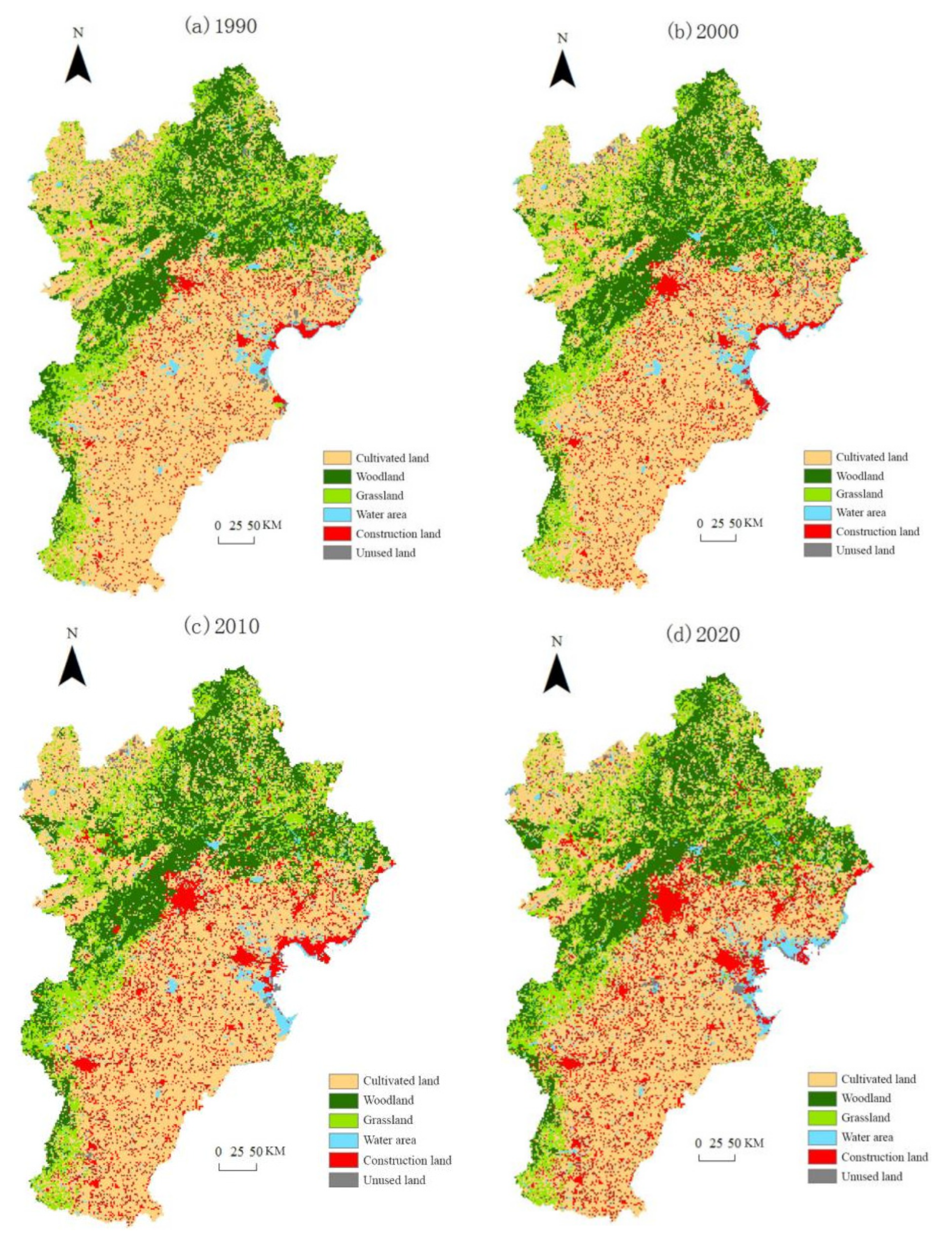
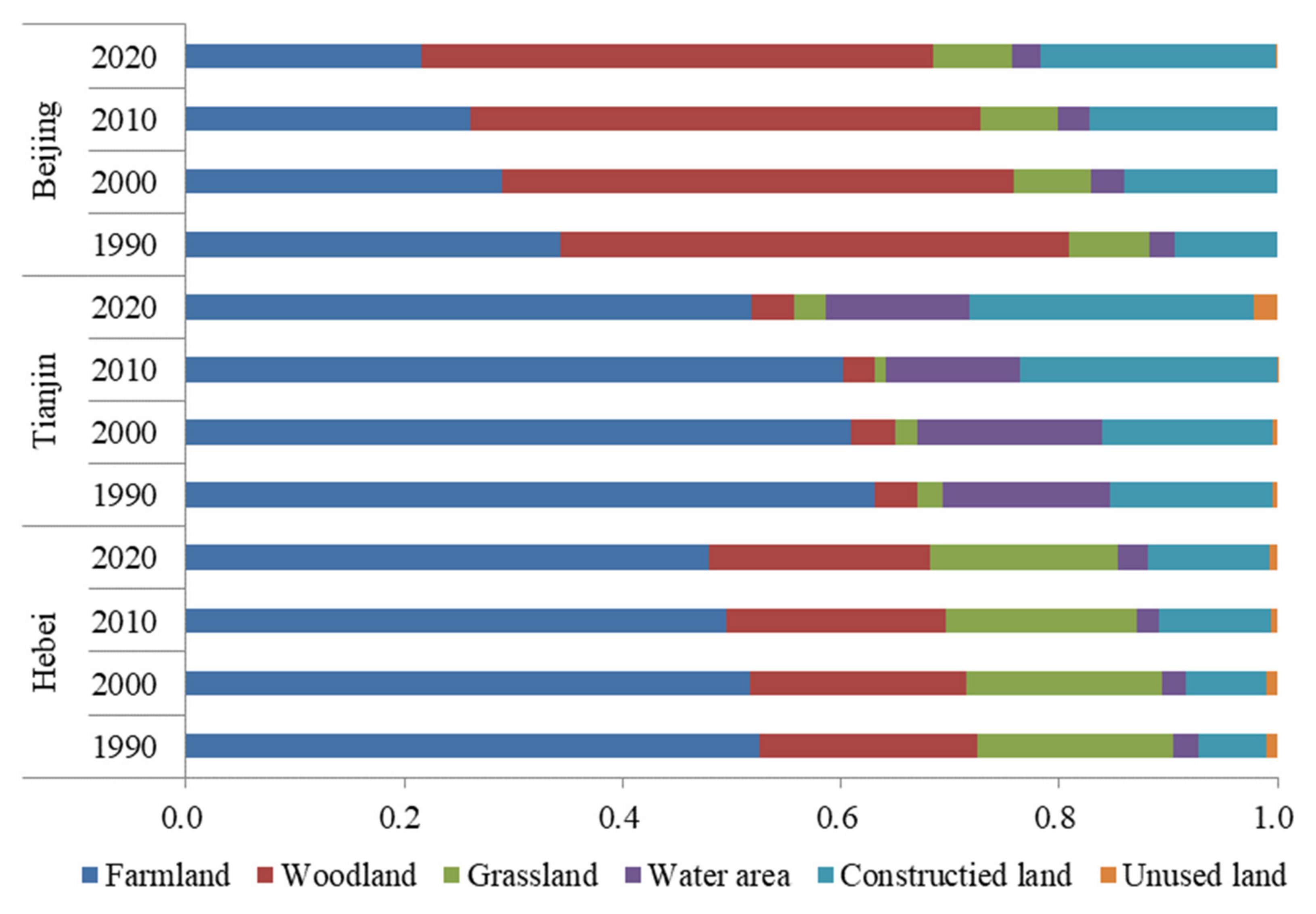
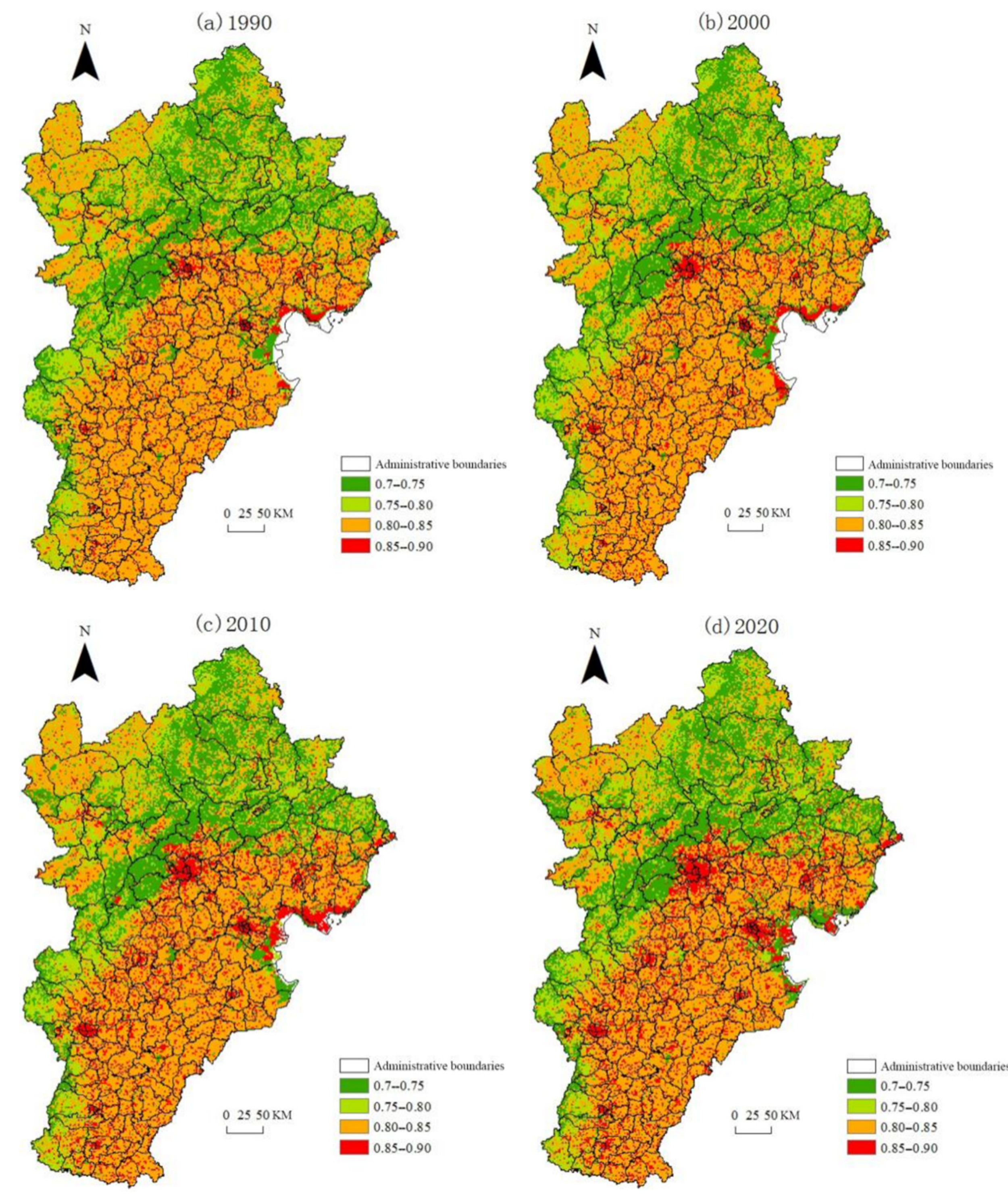
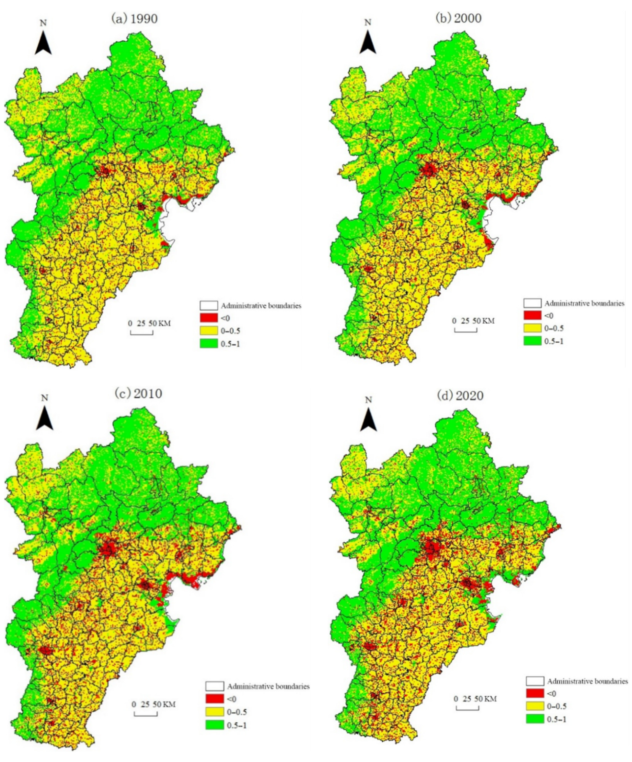
In this study, based on LULC and ES score matrix, explored the spatial distribution characteristics of supply and demand of ES, and revealed the changing trend of supply and demand of ES in the Beijing-Tianjin-Hebei region from 1990 to 2020. It has important practical significance for maintaining the stability of the ecosystem in the Beijing-Tianjin-Hebei region, and promoting the sustainable development of the Beijing-Tianjin-Hebei region. The analysis of the driving factors of LULC is the basis for understanding the regular pattern of land use change and predicting future trends of land use change [
46]. Elevation and slope were the main factors affecting the change of farmland and construction land, which played negative roles, so the local government should strictly control the increase of construction land in areas with high elevation and steep slopes, meanwhile, encouraged returning farmland to woodland and grassland in those areas. The distance to the county government was the most important driving factor for construction land, so the intensive use of construction land should be paid more attention. The supply and demand of ES in Bashang Plateau and Yanshan-Taihang Mountain area were in surplus, and the range of change was very tiny, showed that a series of ecological projects, such as the Beijing-Tianjin sandstorm source control project, the Three-North Shelterbelt Project, the Taihang Mountain greening project, had achieved specific results, restored the amount of local ecological land to a certain extent, and improved the regional ecosystem service function. The supply and demand of ES in plain areas of Hebei Province, Beijing and Tianjin were in deficit, the results were consistent with other scholars’ related research in the same area [
47,
48,
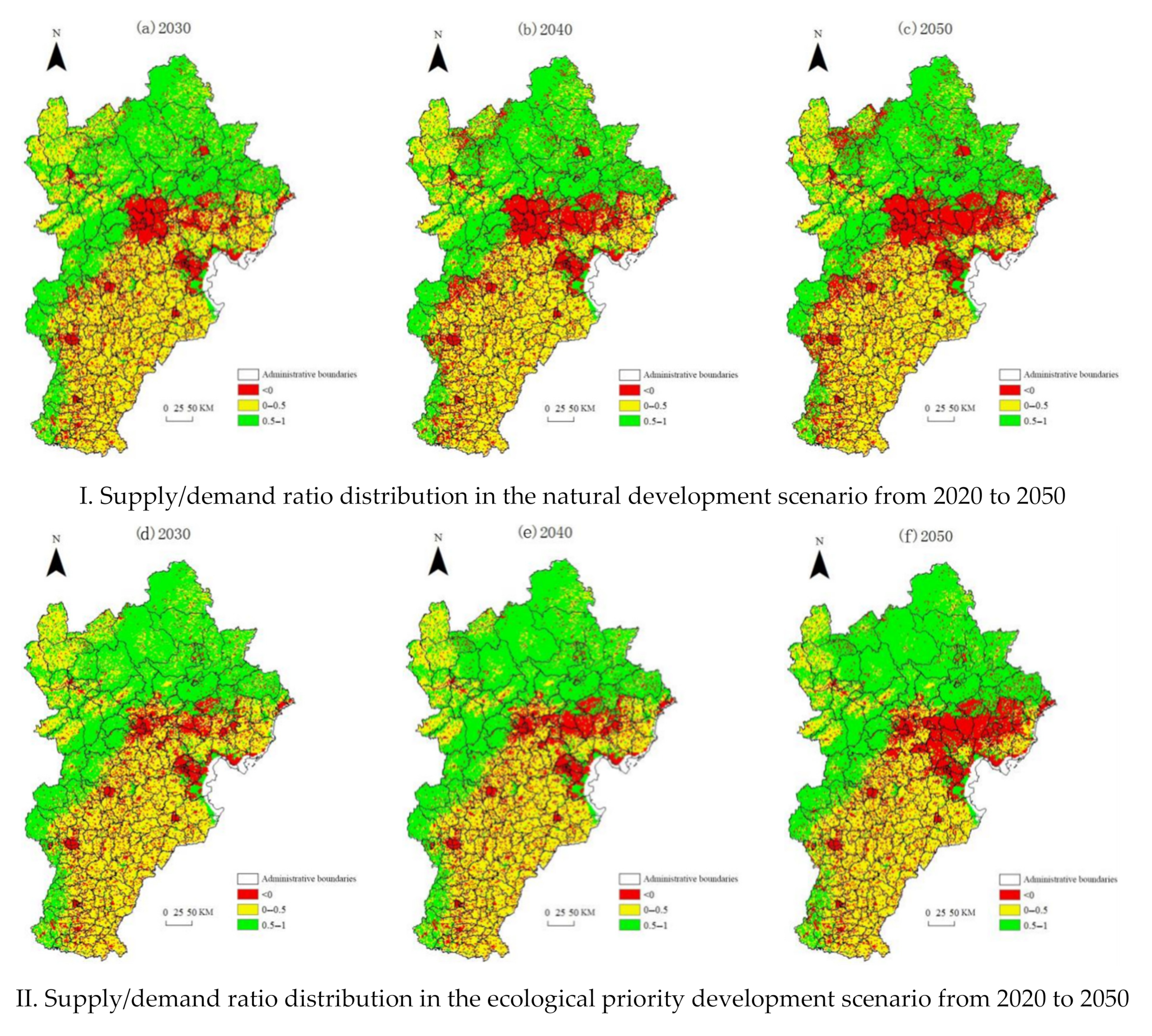
49], and the deficit was constantly increasing, especially in the areas around the cities of Beijing and Tianjin, mainly due to the rapid expansion of urban land and the increase of farmers’ residential areas occupying the space of cultivated land and forest land, which leads to a sharp increase in the demand for ES. Therefore, the quantity of construction land in these areas should be strictly controlled, urban boundaries should be demarcated, and disorderly urban expansion must be strictly prohibited.
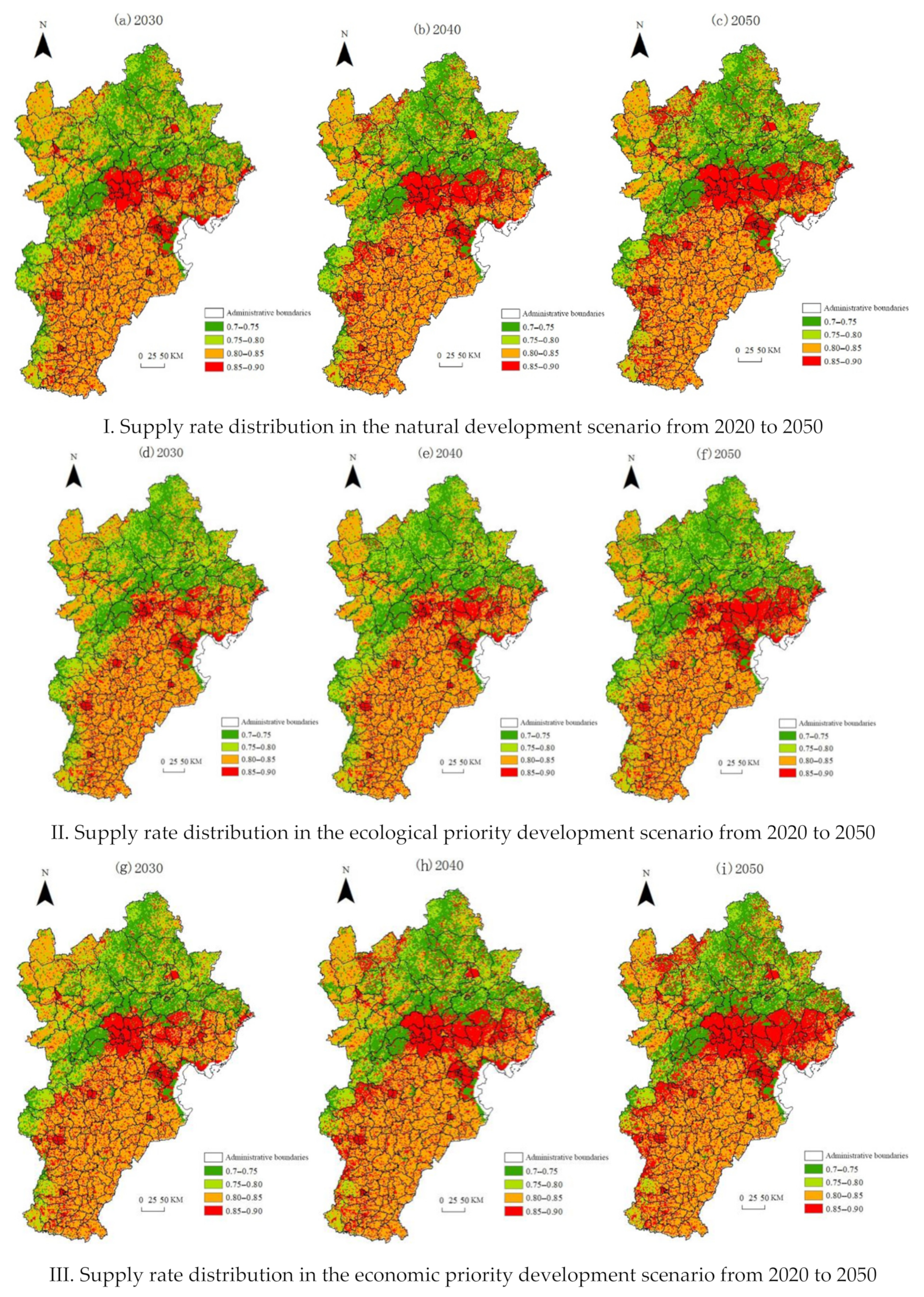
ES analysis appears to be a promising approach for a longer-term response to sustainability issues in general [
50]. ES approaches have become a prominent basis for planning and management [
51]. In this study, the application of the CLUE-S model, combined with the ES score matrix, suggests that the supply and demand of ES from 2030–2050 in three scenarios, the research results can provide support for the formulation of land space planning and ecological construction policies in this region. In the natural development scenario, the ES in the Beijing-Tianjin-Hebei region will remain in a high supply state from 2030 to 2050, but the pressure will be greater than before. The nature-based solutions (NBS) should be integrated in land planning [
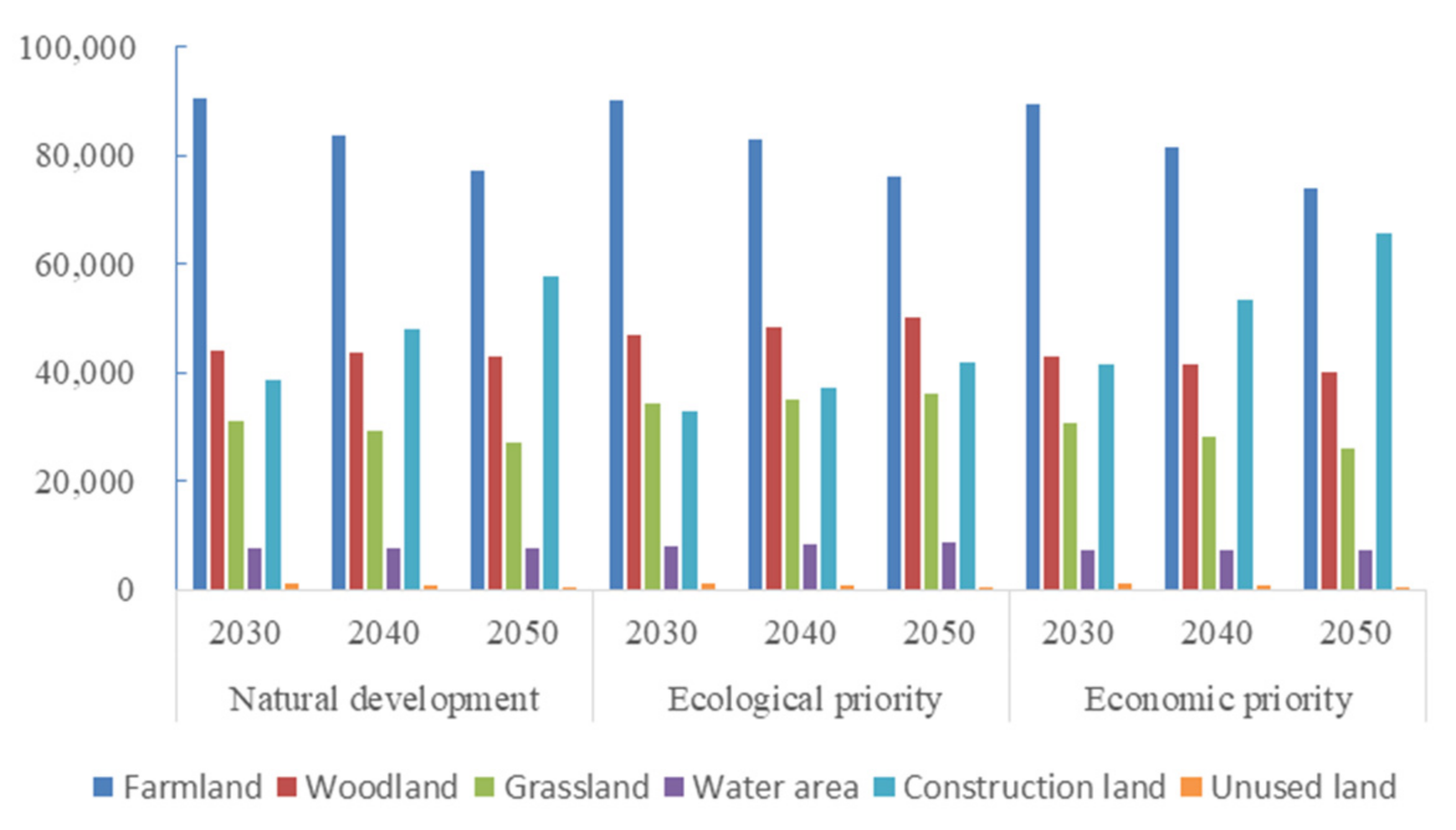
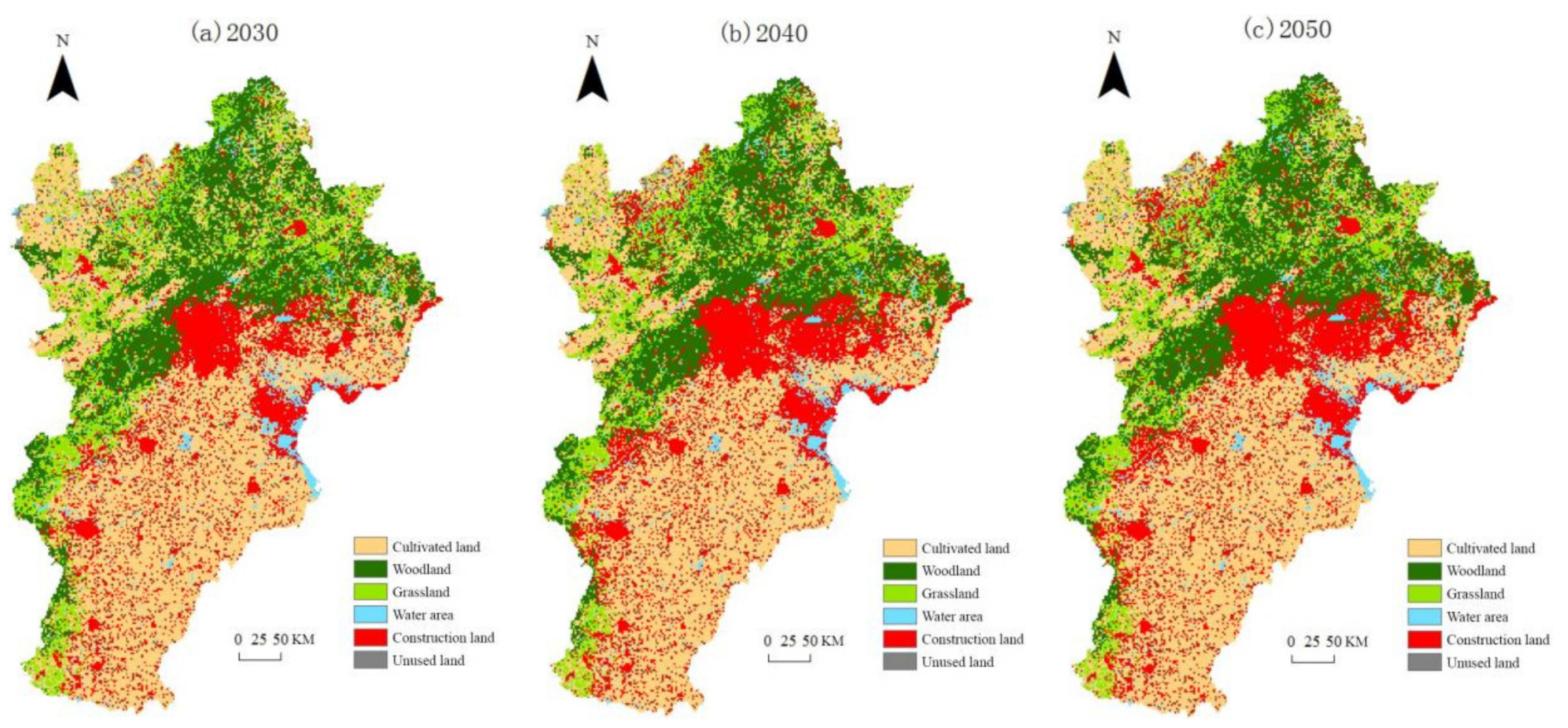
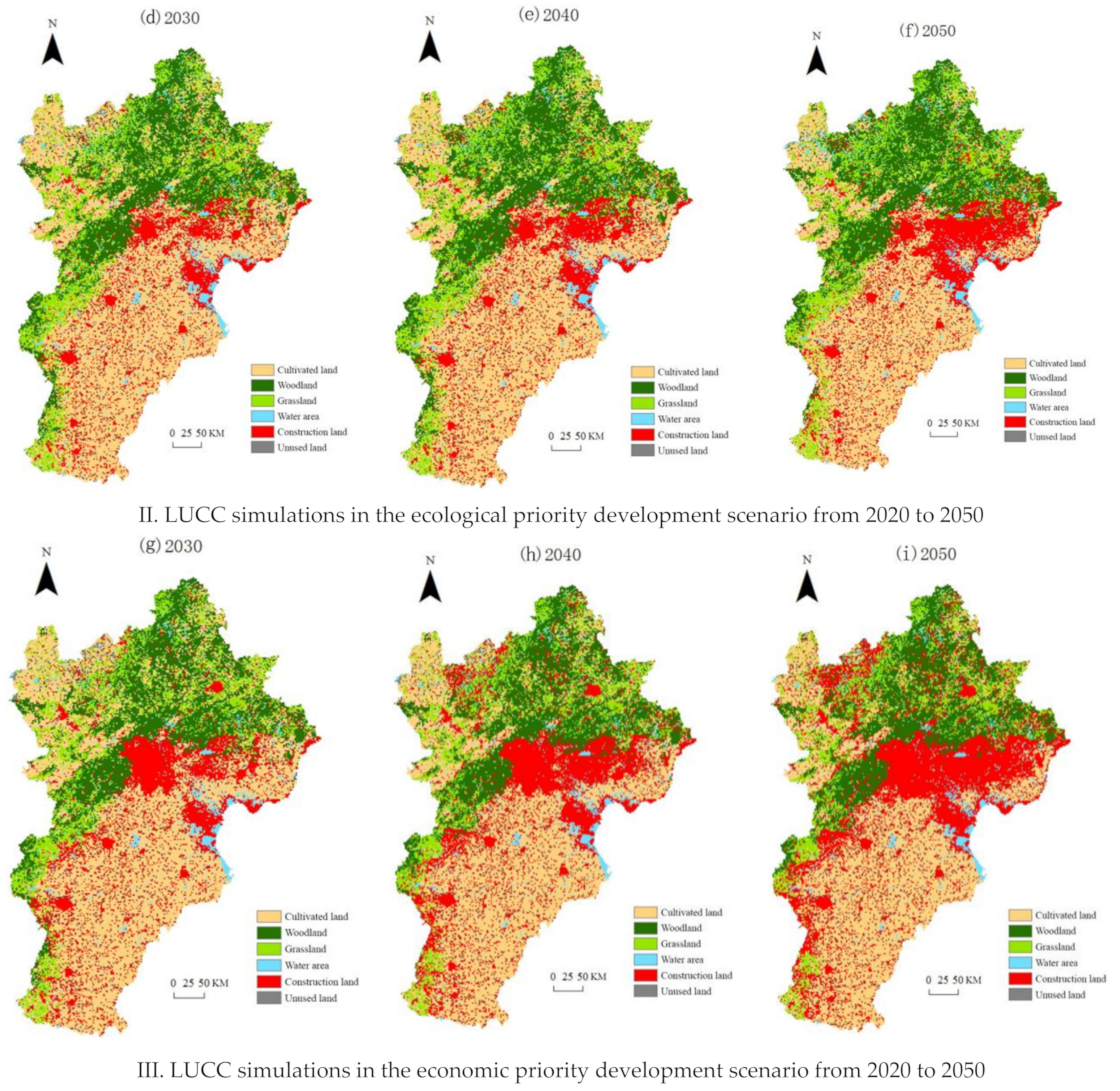
45]; place-specific strategies may include strict preservation zoning in the areas where supply and demand of ES were surplus and redlining in the areas where were deficit. The population and the amount of urban land should be strictly controlled, the red line of cultivated land protection should be delineated. The construction of ecological engineering and building ecological barriers in Yanshan-Taihang Mountain areas should be speeded up, included building soil and water conservation forests in the upper reaches of rivers, mines, reservoirs, sand sources and barren hills and wasteland suitable for forest. The protection of wetlands and farmland should be strengthened, and water-saving agriculture should be developed.
The spatial mismatch between supply and demand of ES can produce ecosystem service flow [
52]. Studying the transfer path, flow direction, flow and other attributes of ES from supply area to demand area can reflect the process of ES transfer. Analyzing the quantification and spatialization of ES flow is not only helpful to identify the unsatisfied areas, regulate the process and ways of service delivery, but also helpful to the overall management of decision makers.
5. Conclusions
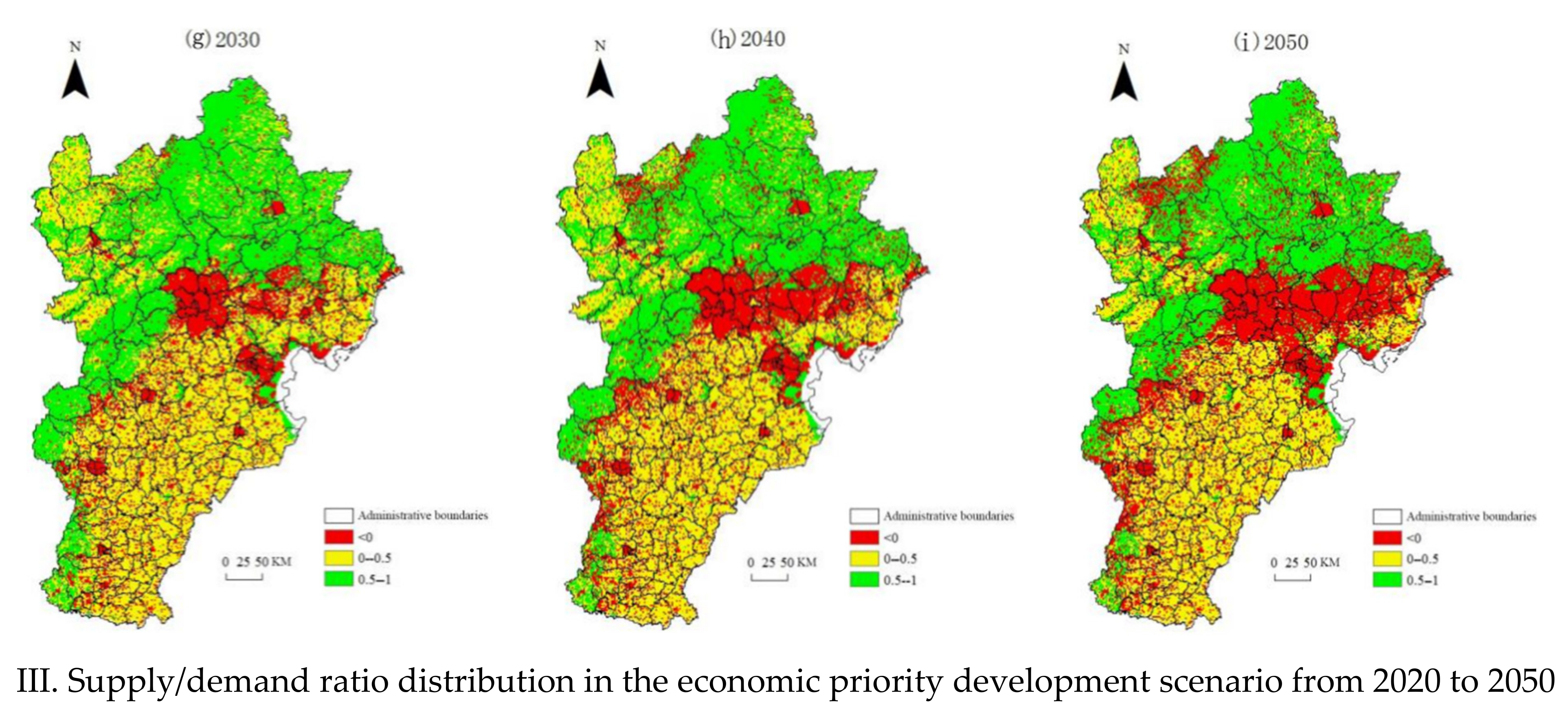
In this study, based on the current LUCC, we conducted a temporal and spatial comparative analysis of the ES supply capacity and ecosystem service supply capacity in the Beijing-Tianjin-Hebei region. In addition, through prediction and simulation of land use changes in different scenarios, we obtained the future spatial pattern of ecosystem services. From 1990 to 2020, the supply of the ES in the Beijing-Tianjin-Hebei region was at a high level, and the ecological environment was worse. During 2030–2050, the ES of the Beijing-Tianjin-Hebei region will still be in a high supply state, and the pressure will be greater than before. The deficit, centered on the urban construction land, will widen and the ecological situation will deteriorate. In the natural development scenario, the ESs in the Beijing-Tianjin-Hebei region will continue to be in a state of high supply from 2030 to 2050, and the pressure will be greater than before. The scope of the deficit in the supply and demand of ESs, which will be centered on the urban construction land, will widen and the ecological environment around Beijing and Tianjin will deteriorate. In the ecological priority development scenario, the pressure on the ESs will be relieved, the rate of the deficit expansion will decrease, and the degree of ecological environmental deterioration around Beijing will decrease. In the economic priority development scenario, the pressure on the ES will increase sharply, the deficit area will expand rapidly, and the ecological environment around Beijing and Tianjin and in the northwestern part of the study area will deteriorate sharply. Therefore, we should balance ecology and the economy to achieve efficient land use and sustainable development in the study area.


