1. Introduction
The colonisation villages built in Spain from the 1940s were part of an important innovative territorial model of great economic, social, and productive interest which transformed the national agricultural landscape. These villages were designed as part of a nationwide intervention within a policy for domestic colonisation and development of agricultural land carried out by the Spanish government between 1939 and 1977. These initiatives were based on the transformation of rain-fed croplands into irrigated croplands and aimed to improve their productivity and to regenerate the agricultural setting and its habitat. The plans were coordinated by the
Instituto Nacional de Colonización (INC, 1939–1971) (National Institute for Colonisation) and later by the
Instituto de Reforma y Desarrollo Agrario (IRYDA, 1971–1977) (Institute of Agricultural Reform and Development), which reworked colonisation plans dating from the early 20th century. This agricultural development policy added to the debate over precarious living conditions and deficient use of the Spanish agricultural fields¸ which had begun in the mid-19th century. This led to the reactivation of rural settings, the renewal of agricultural techniques, and the improvement of the habitat with the construction of the new colonisation villages, which had become an experimental field for modern architecture at this time [
1,
2,
3,
4,
5,
6,
7,
8,
9,
10].
This colonisation plan involved a complete reform of vast areas of land through the regeneration of barely productive land. This was based on the creation of hydraulic infrastructures on different scales, from large reservoirs (around 300 built between 1940 and 1967) to small irrigation ditches distributed throughout the territory [
11,
12,
13,
14]. These infrastructures were followed by other actions, such as reforesting mountains, defending hydraulic basins, reallotting agricultural land into smaller plots and new plantations, creating service roads, and constructing villages for the agricultural workers or settlers—named
colonos—working on the land. These settlers established a sharecropping relationship with the INC for a period of five years. During that time, they were provided with the necessary technical means (animals, tools, seeds, and fertilizers), and had to follow a specific cultivation plan. Once the guardianship period ended, the settlers were free to establish their own planning, continuing to fulfil economic obligations with the INC to amortise the value of the house and the farmland for up to forty years. When the assigned farm unit and house were amortised, the settlers became owners of the lot.
This large-scale operation throughout Spain respected the ecological and geographical characteristics of the territory, providing services and infrastructures to improve the working of the agricultural landscape. These interventions and their formalisation in the landscape and architecture followed several laws expressly conceived for comprehensive planning throughout Spain which regulated the three major colonisation tasks: infrastructure provision, land transformation, and the assignment of land and housing for the settlers to use and develop, guaranteeing living conditions and financial independence.
The first law that would later serve as a reference for the regulation and execution of colonisation was the 1907 “Ley sobre Colonización y Repoblación Interior” (Law on Colonisation and Interior Repopulation). It supported a first block of laws, prior to the constitution of the INC, which were the 1932 “Ley de Obras de Puesta en Riego” (Irrigation Works Law), the 1932 “Ley de Reforma Agraria” (Agricultural Reform Law), and the 1933 “Plan Nacional de Obras Hidráulicas” (National Plan of Hydraulic Works). These three laws determined the creation of the
Instituto de Reforma Agraria (IRA, 1932–1938) (Institute of Agricultural Reform), an antecedent of the INC. The same year that the INC was founded, the 1939 “Ley de Bases para Colonización de Grandes Zonas” (Law of Bases for Colonisation of Large Areas) was enacted, which did not allow the transformation process to start but built its foundations, giving rise to the 1949 “Ley sobre Colonización y Distribución de la Propiedad de las Zonas Regables” (Law on Colonisation and Distribution of Property in Irrigable Areas), the fundamental law of the colonisation carried out by the INC [
15,
16,
17].
The development of this agricultural policy was undoubtedly the greatest agricultural enterprise carried out by the Spanish government, combining geography, civil engineering, agricultural engineering, and architecture in a single joint project throughout the country, specifically adapted to each place.
In drawing up this multi-scale and interdisciplinary project, the main agents taking part were the civil engineers and the agricultural engineers [
2]. The civil engineers were in charge of capturing water and building dams and reservoirs, as well as connecting the land to be developed with new means of communication. The agricultural engineers identified estates with agricultural potential and planned the territory based on the distribution of water for irrigation, the agricultural division of land, and the ideal location of new village settlements to be designed by architects in the culmination of this multi-scale process in Spain.
The almost three-hundred colonisation villages throughout the country soon became the image of the new agricultural policy (
Figure 1a). The use of the term “colonisation” to describe this ambitious project was no accident. According to the dictionary of the Spanish language, the term
colonizar has two meanings: 1. To form or establish a colony in a country; 2. To establish the residence of its agricultural workers on a piece of land [
18]. The second meaning refers to one of the main approaches of the INC’s intervention, which was the installation of the people who would work the land next to their agricultural plots. It was thus a term that linked both the agricultural sector and architecture with a model based on the shared placement within the land of the spaces for work and the homes of the agricultural workers in a modern interpretation of rural settlement with collective facilities. Thus, the term “colonisation villages” highlighted the intrinsically architectural nature of this process of agricultural use of the land, hence its vital importance when creating the image of colonisation as a new form of life in rural settings [
8,
19]. The rural alternative was presented as a viable option, comparable in comfort to life in the city with the possibility of enjoying a healthier setting in contact with “nature”.
This agricultural planning included early interpretations of what is currently known as landscape urbanism or ecological urbanism, used to develop a territory based on the recovery of pre-existing elements, setting up infrastructures and displaying ecological commitment to primarily geographical, productive, social, and even cultural approaches to territory [
20]. The interest of these innovative proposals lies not so much in the specific design of future planning but in the creation of dynamic intervention systems or processes on different scales which make it possible to configure a physical, social, productive and architectural landscape, as Spanish colonisation aimed to do. The recent methodologies for territorial planning and ecodesign led by pioneering laboratories in the emerging field of geodesign [
21], including the Architectural Association School of Architecture and the Harvard Graduate School of Design, promote the integrated participation of different fields of knowledge which affect territories, using environmental awareness as the guiding principle for all interventions when land planning.
Behind these processes and forms of work, we also find a correlation between the different elements making up a landscape and how these translate to the development of land and the subsequent interpretation of architecture, which were always approached from an environmental perspective in colonisation. In 1969, Ian McHarg, landscape architect and chair of landscape architecture and regional planning at the University of Pennsylvania, published his book
Design with Nature [
22], which put forward the importance of preliminary environmental assessment of a location before carrying out an intervention. This book uses the mapping technique to identify the sensitive elements of a territory and their capacity to adapt to the new uses as a form of design—considerations that were important in the context of Spanish colonisation when territories were being selected and the planning and distribution of activities based on the potential for adaptation and development were being undertaken. The interpretation of the colonisation villages viewed from the landscape and the transfer between the elements which make up a territory, as proposed in this research, shows the validity of the model at present, which already in the mid-20th century incorporated many of the modern principles currently used in territorial planning.
The experience of domestic colonisation in Spain is widely known internationally and sits alongside several large-scale policies of agricultural regeneration carried out simultaneously in different countries, including Italy, Germany, Portugal, Israel, and the United States. These policies shared similar objectives and were directed by similar governmental bodies: Instituto Nacional de Colonización, INC, (1939–1971) and Instituto de Reforma y Desarrollo Agrario (1971–1977) in Spain; Bonifica Integrale (1932–1939) in Italy; Junta de Colonização Interna (1936–1951) in Portugal; the Jewish National Fund (from 1897), the Palestine Commission (from 1903), and the Palestine Land Development Company (from 1907) in Israel; and the Tennessee Valley Authority (from 1933) and Columbian Basin Project Act (from 1943) in the United States.
There is extensive evidence pointing to the relationships and influences between these [
4,
11,
23,
24,
25,
26]. The Italian
Bonifica Integrale, for instance, was a point of reference for the early stages of Spanish colonisation, sparking the key debate on which territorial settlement model was best—concentrated or scattered—with major repercussions for the subsequent transformation of the landscape. The Spanish experience was pioneering with respect to certain issues, carrying out major projects which were soon emulated in other countries, particularly expropriation policies and settlements based on the model of territorial concentration, which showed lower levels of landscape disruption and established collective and social forms of operation which were better suited to modern times.
Observing colonisation in Spain, Italy, and Portugal—closer in time and cultural traditions—the scope of the Spanish intervention had far wider repercussions, and there is a record of visits made by Italian and Portuguese technicians to colonized areas in Spain. Portugal developed a more limited colonisation system on a smaller scale, building 7 nuclei or agricultural colonies with social centres and dispersed housing for 510 families. In Italy, the project on Agro Pontino (it is the most analysed and well-known case, although the Bonifica Integrale also intervened in several areas of the Mezzogiorno) was made up of 5 cities or città di fondazione, 20 civic centres or borghi rurali, and approximately 3000 settler homes or scattered poderi for around 30,000 inhabitants in total. These figures are higher in Spain, where there were 300 colonisation villages or pueblos de colonización throughout the country, providing homes for about 60,000 families and 225,000 inhabitants. This reflects the importance of this intervention and its repercussions on an international scale.
To date, these newly constructed rural complexes have been extensively studied and there is an abundant bibliography, approached in most cases exclusively from an architectural perspective. Despite the connection of these villages with their physical context, no studies have provided a written or cartographic analysis [
27,
28,
29] of the territorial and landscape dimension of these interventions [
2,
14,
30] which led to the transformation of the territory and its elements at different scales, geographical and physical, of the orography and relief of the land, or treated of the architecture, infrastructure, and agriculture. This paper proposes a territorial approach to the Spanish colonisation carried out by the INC and a work methodology for the graphic reconstruction of the agricultural landscape prior to colonisation. The aim is to ascertain the importance of landscape and other elements for reallotting land and tracing infrastructures, and the importance of architecture in the implementation and development of villages following a model of concentrated settlement in the territory.
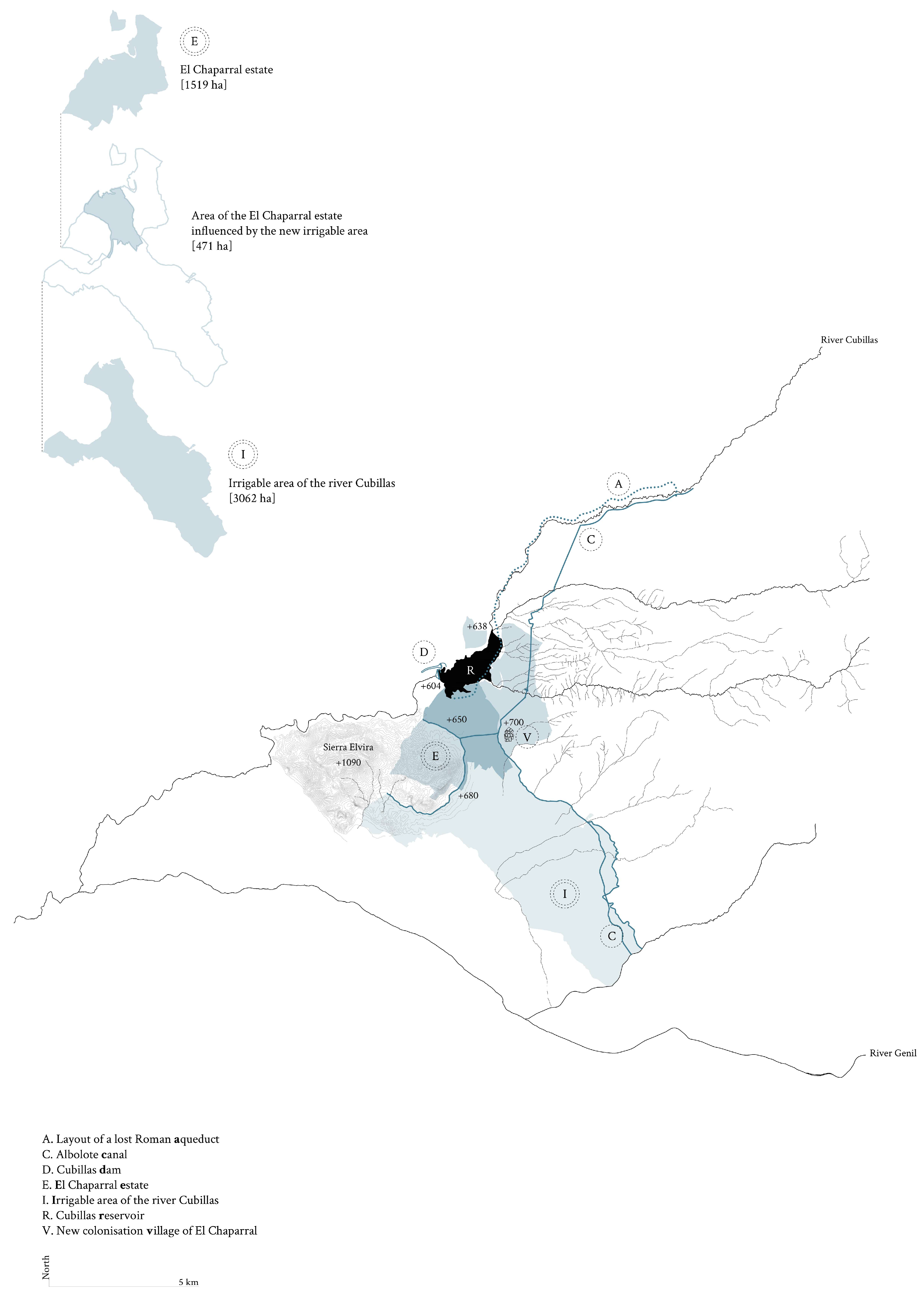
This research is applied in a particular case study of the colonisation village of El Chaparral, linked to the basin of the river Cubillas in Granada (
Figure 1b), an excellent example of this territorial transformation process containing all the elements of a policy for land regeneration. This intervention combined geographical elements relating to channelling water from the river, the creation of a reservoir, the adaptation of land to the new topographies, and the reallotment of land and the implementation of productive agricultural activities relating to the new architectural settlement. This full series of actions on agricultural land and its pre-existing elements came to form a landscape of great interest given the transfer of natural and anthropic elements nearby. In turn, its study has made it possible to carry out a strategy of action rich and complex enough to be extrapolated to other case studies of the colonisation policy for Spanish and European agricultural land, thus expanding knowledge and understanding.
2. Materials and Methods
This research was approached with the adoption of a broad concept based on the anthropological perception of territory, which includes the historic, agricultural, technical, environmental, symbolic, and aesthetic value of the elements which make up a landscape and its relations [
31,
32]. Given that recording and documentation processes are basic to guaranteeing a strategy for the revitalisation of a landscape, this research began by drawing up a graphic census of the sensitive points of the territory, establishing a correlation between its history, identity, and ability to define the most suitable agricultural programmes for the promotion of agricultural, social, economic, and landscape regeneration. Therefore, field methodologies were combined with archival research, creating an inventory of the elements of the territory and recording any other information, including oral accounts from individuals linked to this landscape, making it possible to draw up a complete document of the colonisation of the territory and its landscape.
A mapping and overlay-mapping methodology was followed to establish a correlation between the elements which make up the colonisation process. These principles, used when recording a territory, were extended to infrastructures and architecture and their relationship with the landscape. Mapping requires the joint construction of different aspects: historical, archaeological, technological, environmental, and territorial. This work process entails identifying any connections with forms of interference affecting the elements and history of a landscape. Ian McHarg elaborated on this term, developing overlay-mapping, the superimposition of new layers of information relating to uses, techniques, and forms of life, as well as on the ability to transform a territory and its memory, expanded in this study to include aspects relating to architecture and agriculture. The research also resorts to the methodology used in J.B. Harley’s “critical cartography” [
33] to study anthropic impact on agricultural settings, infrastructures, and cultural meanings. In addition, it takes into consideration geodesign technological representation systems, currently used in territorial planning and development, and in this case applied to the reconstruction of the landscape by different layers and themes.
In order to examine the transformation of the landscape of the El Chaparral estate, this work employs qualitative research based on the recording and graphic reconstruction of the landscape prior to colonisation and on the resulting landscape after the plan was completed. The superimposition of layers of information from different periods makes it possible to establish relationships between both landscapes, revealing valuable information on the transfers which have occurred throughout history. The drawing up these map records is constitutive of the methodology and research process.
The methodology emphasises two basic aspects in order to establish the transformation processes of these landscapes:
Recording pre-existing elements at different scales;
Recording landscapes in different periods (before and after colonisation) and using a comparative cartographic superimposition to detect the transfers between them.
Figure 2 shows the type of information and work processes used for the graphic reconstruction of the current agricultural landscape and that prior to colonisation in order to determine the transfers which took place between both landscapes. The graph represents a working scientific methodological synthesis that can be extrapolated to other locations of Spanish colonisation and even to other agricultural landscapes in which interventions have already been made. It is based on establishing stages for the reconstruction of the landscape in different periods, using documentary and archive sources and fieldwork to finally obtain a superimposed cartography showing the level of transformation of the territory. The study begins by setting up a vectorial cartography prior to colonisation which includes administrative information as well as geographical elements, such as rivers, ravines, irrigation ditches, service roads, topographies, and crops found in the area, onto which new layers of graphic information relating to the colonised landscape are superimposed. The resulting superimposed cartography of both landscapes makes it possible to:
Identify the elements which have survived, been transformed, or disappeared in the territory, as well as establish the transfers between both landscapes (infrastructures, service roads, crops, plots, and architecture) and the evolution of their form and appearance;
To later study and verify the suitability and ecological and environmental adaptation of the colonisation carried out by the INC and the multidisciplinary teams.
4. Discussion
4.1. Relationship with Other Current Research: State-of-the-Art and Innovative Proposals in the Field
In general, the existing bibliography on colonisation is limited to urban and architectural studies of the colonisation villages examined as individual cases removed from the context of their surrounding landscapes. There are barely any documentary studies of cartographies for the transformations in the territory as a result of their establishment. Nor is there any record of the relationships that the settlements and their architectures established with pre-existing elements and the landscape prior to colonisation. The most recent publications of interest—almost all in Spanish—can be described as mere compilations of texts with partial approaches which are exclusively architectural and do not examine the territories or the elements within them. Notable recent publications include the Revista PH monograph entitled
Pueblos de colonización 1939–1971 [
47], the book
Pueblos de colonización durante el franquismo: la arquitectura en la modernización del territorio rural [
7], the 10th Iberian DOCOMOMO Congress on
La huella del Movimiento Moderno: los pueblos de colonización [
48], and the book
Habitar el agua. La colonización en la España del siglo XX [
11]. On the territorial scale and multidisciplinary approach of the policy for domestic agricultural colonisation in Spain in the 20th century, some researchers have provided contributions of a general nature which were expounded in many later studies [
8,
10].
However, despite the extensive bibliography and studies which continue to be carried out, it is difficult to find publications proposing a territorial interpretation of colonisation. One of the few examples is the doctoral thesis by Manuel Calzada Pérez [
2], which highlights the overall importance of colonisation for understanding the role of architecture within this process of transformation for the landscape. In keeping with this, Víctor Pérez Escolano, a renowned author in the field, calls for a territorial interpretation to explain the transformative power of colonisation: “The study of colonisation villages requires a perspective which logically cannot be limited to isolated urban or architectural works, but should be seen from the comprehensive perspective of their place in the territory, their landscape values, the consideration of the production of hydraulic engineering…” (translation by the author) [
14] (p. 41).
This study presents a reflection from this perspective, proposing an innovative work methodology for research on settlements, aiming to detect the key to their establishment and development from a territorial perspective. To achieve this, the proposed study records a comparative cartographic analysis of the elements of a territory both before and after colonisation. The innovation of this process lies in the fact that the research on settlements is carried out according to the scale and complexity of the landscape rather than limiting its focus to architecture and urbanism. In this way, architecture is recognised as part of the system of loading an agricultural territory, without which it is meaningless. It also incorporates aspects which had not been taken into consideration in the research until this point and which are linked to the multidisciplinary approach of the intervention, including the history and pre-existence of agricultural elements and land infrastructure, the superimposition of landscapes from different eras, and the superimposition of comparison cartographies to detect transfers between these landscapes. This methodology constitutes an advance in the study of colonisation villages and territorial planning following current geodesign principles. This is the first step in determining the level of ecodesign and integration of these interventions.
4.2. Application of the Research to Other Agricultural Territories: Predominant Aspects and Limitations
This work methodology was applied in a case study of El Chaparral, a prime example of the integral intervention of the colonisation policy of the Spanish agricultural policies and an exceptional representation of planning goals. Due to its nature and characteristics, it can also be extended to other cases of Spanish colonisation and by extension to the reconstruction of transformed agricultural landscapes and to the study of developing agricultural land where a historical correlation with the territory and prior elements can be established. The epigraphs and sections of the methodology (
Figure 2) establish an order for the sequence of actions in the stages of work and recording, as well as for the themes, information development scales, and comparative analysis procedures used.
It is clear that the geographical information systems (GISs) developed since the 1990s have helped to structure and organise the levels of involvement of activities, individuals, and stakeholders intervening in a territory, shedding light on their presence and relationships. Perhaps the scarcity of research offering comprehensive visions of the landscapes of colonisation villages is due to the lack of technological resources and digital tools with which to study them effectively. At present, new techniques make it possible to analyse these landscapes and to improve the understanding of the process of territorial planning and the implementation of infrastructures and activities. Recent techniques such as geodesign have used scientific methodologies to formalise the relationship between GIS and the different disciplines working in geographical spaces. Thus, they open up an integrated field to explore territorial design and planning, including the relationship of architecture with landscape, activities, and any type of anthropic intervention in a geographical territory (soil, hydrology, roads, uses, modification of topography, crops, etc.). These developments have been combined with the information strata (monitored by renowned laboratories directed by authors such as Carl Steinitz, Jack Dangermond, Bran Ferrer, and Henk Sholten) that have been used to develop this comprehensive multidisciplinary investigation of territories.
A study based on the application of the geodesign technique to plan new territories incorporating environmental sciences, social sciences, and economics allows the field of colonisation research to extend to ecological, social, and economic aspects, along with others relating to production profitability. To carry out this pending task, it is necessary to form multidisciplinary research teams to address and verify, from the perspectives of different specialities, the suitability and ecological adaptation of the colonisation carried out by the INC. This research would make it possible to analyse and demonstrate the positive results of the agricultural intervention on the landscape and the possible negative impact of land transformations, especially those linked to large hydraulic works (soil erosion, alteration of the environmental balance, road restructuring around reservoirs, etc.). These are fundamental issues that are also relevant to the question of the possible lack of ecological sensitivity in the aforementioned landscape urbanism or ecological urbanism, following the approach of authors such as the landscape architect Charles Morris Anderson in relation to his theory of emo urbanism [
49]. These considerations are outside the constraints of this research focused on architecture, urbanism, engineering, and the identification of the different issues of landscape transformation.
As a preview of this future interdisciplinary perspective, in the case of El Chaparral, the argumentation presented here seems to indicate that the INC acted with sensitivity towards the territory prior to colonisation. A more complex, heterogeneous, and rich landscape was configured through the provision of infrastructures and the adoption of new agricultural approaches, acting with consideration of the pre-existence, resources, and conditions of the territory.
4.3. Implications of the Work for the Design and Planning of Landscapes: Expectations for the Development of Agricultural Land
Through the use of a series of relational cartographies for periods and aspects in relation to a given territory, the proposed methodology makes it possible to establish a process for recording the evolution of an agricultural territory and its transformations. Complementing this work methodology, this paper argues for colonisation as a model for consideration in the development of agricultural land and the study of tangible capacities for integration. In the 19th century, over half the world’s population worked in the country, whereas now this figure stands at 2%. Rural depopulation in Europe is now one of the challenges faced by the countries of the European Union. Although rural regions make up 80% of the continent’s surface, they house 30% of the European population, now affected by the increasing depopulation of the countryside, which, in turn, is causing a territorial imbalance with serious consequences. At the European level, planning aims for the coming years contemplate a policy for restructuring the territory, creating and improving territorial infrastructures, and making an economic investment in new habitability and production models for rural settings. Spanish agricultural colonisation already identified these aspects as priority objectives for territorial transformation.
In this era of the COVID-19 pandemic, in which a rediscovery of nature and the return to rural settings are being promoted, colonisation villages are a major point of reference which open up lines of research and discussion of the relationships between urban development and the environment, circular and zero km economies, and models for urban planning and agricultural production in sustainable and ecological conditions. It therefore seems relevant to study and update the field of colonisation in order to establish the extent to which this model could help to re-establish a balance in depopulated territories and the interest that these proposals might now have for the development of planning and management of agricultural landscapes. Issues such as who the “contemporary settlers” are, the potential interest of these models in relation to a return to the countryside in our globalised society, or how a production and housing model can now be agreed on while taking into account a territory’s capacity for anthropic transformation in ecological conditions with minimum transformation underlie all this research and open up a field of exploration for the immediate future. It is clear that rural life as an alternative to city life is becoming an increasingly viable possibility for the coming years.
5. Conclusions
The Spanish domestic colonisation of the mid-20th century was an innovative territorial planning project which fell within the framework of the agricultural reform policies seen in different European countries and in the United States. These had major repercussions on the transformation and habitability of rural landscapes. The Spanish experience, with almost three hundred villages distributed throughout the territory, occupies a dominant position on an international scale for its scope and for its social, productive, and architectural repercussions, and has made a major contribution, influencing landscape planning in other countries. Although Spanish colonisation could not be said to have followed an ecological and environmental theory or to have been developed with special awareness at the outset of the project, the actions carried out by the different institutions and professionals taking part (civil engineers, agricultural engineers, and architects) did take these issues into consideration and the actions were part of a comprehensive approach sensitive to the characteristics of the territory in which the interventions were made. Spanish colonisation was therefore a pioneering model based on the coordination of different disciplines relating to the study of the territory (engineering and architecture) and the incorporation of ecological solutions integrated into the surroundings. It is possible to find here correspondences with some of the current proposals used in landscape urbanism, ecological urbanism, and geodesign, which promote the integrated participation of different fields of knowledge for the design and planning of the development of land and its uses based on its characteristics and identities.
In general, Spanish colonisation required a territorial planning model based on the formal continuity of elements and pre-existing elements which made up the pre-colonisation landscape transferred and adapted to the new agricultural production conditions, with solutions requiring minimal energy for territorial transformation. The El Chaparral case study selected illustrates the intentions of this integrated planning adapted to the surrounding conditions. Hydraulic and infrastructure projects, along with agricultural and architectural schemes, were completed, taking into account pre-existing territorial elements and acting in continuity and coherence with them. This is reflected in the original technical reports for the projects and can be seen in the comparative study of the landscape before and after colonisation in the graphic documentation drawn up for this research.
In spite of this desire for integration into the landscape and its elements, the studies carried out to date on the colonisation villages have been focused on a strictly architectural perspective, far removed from the original design intentions that were part of the integrated territorial planning. There has been barely any reflection on the landscapes in which they are found and to which are owed many of the decisions influencing urban and formal configurations and urban and architectural implementations. The research shows that only through the study of a landscape on different scales and analysis of its transformations is it possible to understand the true scope of colonisation. It is also possible to comprehend the meaning of the actions performed, which were often prompted by the relationship with pre-existing elements, and the adaptations made in agricultural contexts and to infrastructures through the transfer and transformation of elements found in the landscape before colonisation. This text and the work methodology proposed can be added to this line of research, reconciling the architecture and urbanism of the colonisation villages with the landscapes in which they were built.
In order to determine the levels of involvement of colonisation with the landscape, this research proposes a scientific methodology for reconstructing pre-colonisation landscapes to determine the transfers and levels of transformation of agricultural territories where this planning was carried out. The methodology examines different scales of work, from territorial to small-scale pre-existing elements, establishing a graphic register of information strata with the different aspects which converged in the colonisation process: the major hydraulic works, the creation of networks of irrigation canals and service roads, the agricultural transformation of land and crops, and finally the establishment and design of the new colonisation villages. This work method also made it possible to identify elements and their heritage value, as well as verify the ecodesign and adaptability of colonisation, aspects which had not been addressed up until now. The comparative analysis of cartographies superimposed on the same landscape in different periods helps to determine the level of transformation of the elements which make up these landscapes, their transfers, and the evolution that can be observed to date. The methodology applied in this study to the case of El Chaparral could be extended to the broader field of Spanish colonisation research. It also serves as a point of reference for the study of agricultural land, providing a historical timeline of its elements and helping to elucidate the relationship between architecture and landscape.
In this period of rediscovery of nature due to the COVID-19 pandemic and when the European Union is promoting a policy for the restructuring of territories to tackle rural depopulation, the proposals for colonisation are still in place and are a point of reference providing food for thought regarding future agricultural developments and habitability in our global society, the agricultural production models of proximity, and how to carry out ecological, sustainable, and comprehensive planning that takes into consideration the different disciplines which view landscape as a cultural factor.


