Article

Assessment of Pleistocene Aquifer Vulnerability to Saline Intrusion in the Coastal Region of Ba Ria-Vung Tau Province Using GIS and Entropy-GALDIT

1
Institute for Environment and Resources, Vietnam National University, Ho Chi Minh City 700000, Vietnam
2
The College of Management for Agriculture and Rural Development 2 (CMARD 2), Ho Chi Minh City 700000, Vietnam
*
Author to whom correspondence should be addressed.
Sustainability 2023, 15(10), 8107; https://doi.org/10.3390/su15108107
Submission received: 11 April 2023 / Revised: 3 May 2023 / Accepted: 15 May 2023 / Published: 16 May 2023
(This article belongs to the Section Soil Conservation and Sustainability)

Abstract

:
Sea-level rise, in the context of climate change, increases the likelihood of seawater intruding into coastal aquifers. This study assesses the vulnerability of the Pleistocene aquifer in the coastal area of Ba Ria-Vung Tau province, Vietnam. Data for calculation and analysis were collected from 99 boreholes in the study area. Using the vulnerability assessment index (GALDIT) with expanded weights, the vulnerability of the aquifer to the influence of coastlines was evaluated and visualized in a GIS environment. The set of Entropy weights used clearly shows the significance of the component parameters and indicates the characteristics of the risk partitioning of aquifer salinization. The Entropy-GALDIT results divided the Pleistocene aquifer in the coastal area of Ba Ria-Vung Tau province into three levels of vulnerability: high vulnerability zones (3.88% of the area), medium vulnerability zones (55.47%), and low vulnerability zones (40.65%). According to the GALDIT susceptibility zoning map, the western area of Phu My town (along the Thi Vai River), the southwest region of Vung Tau City, and the southeast region of Dat Do District are highly sensitive and not recommended for any purpose. This result provides useful insights into the vulnerability of aquifers in the coastal area of Ba Ria-Vung Tau province, with respect to factors such as the height of the groundwater level above sea level, the distance from the shore to the wells, and the impact of existing seawater intrusion. Accordingly, it is necessary to establish monitoring systems to warn of saltwater intrusion and to develop integrated resource management strategies to ensure the sustainability of groundwater resources in the area.

1. Introduction

The coastal environment is under stress from socio-economic development activities, urbanization, tourism, and industrial and agricultural operations [1]. Seawater intrusion into groundwater has been observed in coastal areas around the world [2,3,4]. When groundwater is extracted, it forms funnels and reduces water pressure, resulting in the leakage of high salinity water into confined aquifers, which reduces groundwater quality [5].
In recent years, researchers have evaluated groundwater quality using algebraic methods based on characteristic parameters to manage water resources, including zoning and monitoring. The GALDIT index, developed by Chachadi and Lobo Ferreira in 2001 with corresponding parameters, has been used to assess the potential for seawater intrusion into aquifers in coastal areas [6], and was more thoroughly corrected in 2005 [7]. The index considers factors such as G—groundwater occurrence, A—aquifer hydraulic conductivity, L—height of groundwater level above sea level, D—distance from the shore, I—impact of existing status of seawater intrusion, and T—thickness of the aquifer, to assess the overall potential of seawater intrusion in each hydrogeological region. The GALDIT index uses measurable parameters calculated with available data from various sources, without the need for in-depth analysis. The system includes three crucial components: weights, ranges, and ratings. The relative importance of each factor in the GALDIT index is assessed by comparing it to the other factors [7]. For instance, Subbarayan Saravanan effectively applied this model in 2019 and demonstrated the significant impact of saline intrusion in near-coastal areas [8]. Kardan Moghadam et al. [9] compared the DRASTIC and GALDIT methods for assessing the vulnerability of coastal aquifers and found that GALDIT provided better results and was more highly correlated with total dissolved solids (TDS) based on a Pearson test.
However, the GALDIT model is a method of assessing the sensitivity of the parameters based on weights, so it should be adjusted depending on the research area. Currently, the GALDIT index is used around the globe with a variety of weights to suit the conditions of the research area, such as by using AHP and Entropy. In particular, the AHP-GALDIT model, which uses the analytical hierarchy process (AHP) method on the basis of GIS technology, is a more effective approach than the original model [10,11,12,13,14].
Entropy is a useful method in addition to the weights that are optimized by the AHP approach. This method measures the degree of data dispersion objectively based on the variability of each value and depends on the data source for each parameter in the GALDIT model. It is utilized all over the world [15]. The GALDIT index with variable weights with respect to Entropy increases the index’s ability to produce results that are more pertinent to actual conditions, reducing the uncertainty of the methodological framework for managing saline coastal aquifers [16,17]. In Iran, Mojgan Bordbar et al. [16] improved the GALDIT index with Entropy weights integrated with GIS to map the vulnerability of the Gharesoo-Gorgan Rood coastal aquifer affected by seawater intrusion due to the overexploitation of groundwater. The results demonstrated that areas affected by seawater intrusion into coastal aquifers can be more precisely identified using adjusted weights of GALDIT, given the actual conditions. Similarly, Jeong-Seok Yang et al. [17] applied Entropy-GALDIT to examine the vulnerability of aquifers in coastal Benin, west Africa. According to the results, the height of the groundwater level above sea level, the distance from the shore to wells, and the thickness of the aquifer significantly influence the results of vulnerable zoning for saline intrusion. The Entropy-weighted GALDIT results have improved, are consistent with actual conditions, and have a high correlation with TDS.
In Vietnam, in recent years, many researchers have become interested in using the GALDIT model to assess the vulnerability of coastal aquifers to saline intrusion [18,19,20,21]. However, the majority of research still applies the original weights of the method framework and has not shown the spatial distribution visualization of each component parameter. The GALDIT method was utilized in the study of Tran Thanh Canh et al. [18] to map the zoning of the vulnerability of aquifers in Tien Giang. According to the parameters, “the height of groundwater level”, “the distance from the study site to the saline line”, and “the impact of existing status of seawater intrusion”, the very high vulnerability zones were close to the saline boundary and had a large water-lowering funnel. Similarly, Phan Nam Long and Huynh Tien Dat [19] also applied GALDIT based on GIS to assess groundwater vulnerability due to seawater intrusion in Quang Nam and Da Nang. They identified areas of high vulnerability distributed along the coast and in densely populated areas near rivers. Another study in Ninh Thuan [20] also applied GALDIT to assess saltwater intrusion in arid areas, with the weights of the method framework calculated by an analytical hierarchical process (AHP). The results indicated that, under the impact of groundwater extraction and sea level rise, the most vulnerable area in the region was mostly on the central coast and extended inland. In Ba Ria-Vung Tau province, Nguyen Hai Au and his associates [21] first applied the integration of the GIS and GALDIT models with original weights as proposed by Chachadi and Lobo Ferreira in 2005 to assess and divide the vulnerability of the Pleistocene aquifer (Upper-Middle) in Phu My town.
The Pleistocene aquifer in the coastal area of Ba Ria-Vung Tau province is utilized to supply domestic water and to support socio-economic development, agriculture, industrial activities, and tourism. The increasing demand for freshwater use is causing many environmental problems, especially the salinization of groundwater in the context of climate change and aquifer exploitation. The GALDIT approach framework with original weights or expert opinion weights has been used in previous studies in Vietnam to evaluate the vulnerability of coastal aquifers. The influence of parameters in the index based on the variability of each value and the dispersion of the feature dataset have not been considered. Therefore, this study proposes to modify the weights in the GALDIT index through the Entropy method to measure the effectiveness of the information and the dispersion of data [22] in the GIS environment. This method reflects the characteristics of the area that have a major influence on the sensitivity of groundwater quality and enables visualization of the zoning results. The study seeks to enhance the GALDIT methodology framework’s capacity to evaluate and zone coastal aquifers’ susceptibility to seawater intrusion while providing decision-makers with the means to develop a sustainable water resources management plan.

2. Materials and Methods

2.1. Study Area

The investigation was conducted in Ba Ria-Vung Tau Province, which is a province in the southeast coastal region of Vietnam. The coastal area selected for this study includes Vung Tau City, Ba Ria City, Phu My town, Long Dien, Dat Do, and Xuyen Moc districts. The study area has a total area of about 1473 km2 and is located in the tropical monsoon region, which has two distinct seasons and high temperatures (Figure 1). The geography is characterized by low hills, low shelf plains, and coastal plains with clear gradation, with terrain elevation varying from 0 m to 710 m. The entire hydrological network in the west and south bordering the sea is heavily influenced by tides and river flow into the interior since the East Sea covers the entire southern and southeast boundaries of the province. Ba Ria-Vung Tau province has diverse soil composition, including all kinds of granite, shale, basalt, ancient alluvium, river and stream alluvium, sea sand sediment, and marine marsh sediments. Economically, the majority of local people depends mainly on agricultural activities, aquaculture, and salt production. Additionally, groundwater extraction for domestic purposes is still taking place in the province, primarily from the Pleistocene aquifer.
The pore aquifer of the Pleistocene sediments is widely distributed throughout the coastal area of Ba Ria-Vung Tau province, sometimes interrupted by scattered or remnant mountains or erosion. This is an important aquifer in the area, mostly covered by the Holocene water-poor formation, with some areas exposed on the surface. The depth to the water table of the aquifer is distributed from 0 up to 35 m. Its thickness ranges from 6 to 56 m and tends to be tapered towards the mountain with an exploitation flow of up to 39,809 m3/day. The Pleistocene aquifer is primarily composed of fine- to medium-grained sand that contains gravel, with certain areas also including thin lenses of silty clay, fine sandy silt, and coarse-grained soil. The aquifer conductivity varies from 3.86 m2/day to 152 m2/day [23]. The aquifer type is confined; there are noticeable seasonal variations in groundwater level with amplitude ranging from 0.51 to 4.57 m. Sodium chloride, chloride-bicarbonate sodium, and bicarbonate-chloride sodium-calcium are the three basic forms of groundwater chemistry. Total mineralization is high (17–3200 mg/L). The saline boundary has extended deep inland with a negative impact on groundwater quality [24]. To assess the impact of saline intrusion in the area, four parameters, including chloride (Cl), bicarbonate (HCO3), carbonate (CO32−), and total dissolved solids (TDS) were used from a dataset of 99 groundwater wells in the coastal area of Ba Ria-Vung Tau province. The wells were domestic exploitation wells of the Center for Rural Water Supply and Sanitation and boreholes from the national groundwater monitoring system.

2.2. GALDIT Index

The Seawater Intrusion Vulnerability Index (GALDIT) is one of the most popular vulnerability assessment frameworks for coastal aquifers, consisting of six parameters: groundwater occurrence (G), aquifer hydraulic conductivity (A), height of groundwater level above sea level (L), distance from the shore (S), impact of existing status of seawater intrusion (I), and thickness of the aquifer (T). This framework uses a rating system multiplied by the weight of each parameter to assess the vulnerability of coastal aquifers. In addition to the parameters representing hydrogeological factors, the GALDIT index also considers the physical properties that affect the possibility of seawater contamination in the hydrological environment. According to [7], four levels of scores of 2.5, 5, 7.5, and 10 are suggested in this framework for each parameter, where the vulnerability increases as the score value rises and vice versa.
The range and rating values for each parameter in the GALDIT index are shown in Table 1. The aggregate GALDIT value is obtained by combining different layers in the ArcGIS software version 10.4.1, according to the following formula:
GALDIT = i = 1 6 W i   ×   R i i = 1 6 W i
where, Wi is the weight of the ith indicator and Ri is the importance rating of the ith indicator.

2.3. Entropy—Weighted GALDIT

In this study, the weights Wi are calculated by the Entropy method to replace the basic weights in the GALDIT index of Chachadi [6], named Entropy-GALDIT. These steps are used to determine the entropy weights [16,17]:
According to the data, the initial matrix X is the eigenvalue of six parameters in the evaluation index, which is constructed based on the dataset of 99 observation wells in Ba Ria-Vung Tau province (m = 99; n = 6) as follows:
X = x 11 x 12 . x 1 n x 21 . x m 1 x 22 . x m 2 . x 2 n .   . . x mn
where, i = 1, 2, …, n; j = 1, 2, …, m.
After grading each evaluation index, the matrix is obtained as follows:
  X = ( x ij ) m × n
The percentage of the index value of jth in sample ith represent the probability of vulnerability:
p ij =   x ij i = 1 n   x ij
ej of each ith evaluation parameter is determined as follows:
e j = - 1 mn i = 1 n p ij · ln ( p ij )
The entropy weight of the evaluation parameter i is calculated according to the following formula:
ω i = 1 - e j j = 1 m ( 1 - e j )
The results of the Entropy weights of the GALDIT parameters were calculated, clearly demonstrating the significance of the component parameters (Table 2). From the entropy weights in the GALDIT model, the relative ratings based on the importance of the parameters depend on the regional aquifer condition data rather than the specified ratings.
The weights are expanded for each component parameter according to the dataset as a result of the relative change in the classical weights of GALDIT through the Entropy method. The Entropy-GALDIT formula is written as follows:
Entropy - GALDIT = i = 1 6 W ei   ×   R i i = 1 6 W ei
where, Wei: Entropy weights of ith parameters.

2.4. IDW (Inverse Distance Weighting) Interpolation Algorithm

For the purpose of constructing the best approximation surface to the existing data, the spatial interpolation method IDW, a tool that is integrated into ArcGIS, was applied to spatially interpolate the component layers.
Z 0 = i = 1 N Z 1 ×   d 1 - n   i = 1 N d i - n
where, Z0: estimated value of variable z at point i; Zi: sample value at point i; di: the sample point distance for point estimation; and N: the coefficient for determining weight based on a distance.
The process for determining the vulnerability partition of the coastal aquifer and the methods used are shown in Figure 2. The parameters were interpolated, and the component map layers were constructed for each parameter. The Entropy-GALDIT algorithm was used to superimpose the interpolated layers.

3. Results

3.1. Component Parameter Layers in GALDIT

The following regional geological and hydrogeological parameters were used to generate the six layers of the component maps for the GALDIT index combined with GIS (Figure 3):

3.1.1. Groundwater Occurrence (G)

The groundwater in geological aquifers is divided into four types: confined aquifer, unconfined aquifer, leaky confined aquifer, and bounded aquifer. The degree of seawater intrusion depends on the nature of the aquifer [7]. Unconfined aquifers without an impermeable upper layer are more susceptible to impact than leaky confined and confined aquifers under natural conditions [25]. However, confined aquifers are more sensitive than unconfined aquifers by seawater intrusion according to previous studies in the area and hydrogeological documents from the Department of Natural Resources and Environment of Ba Ria-Vung Tau Province [24,26]. The aquifer type map shows that the Pleistocene aquifer in the coastal region of Ba Ria-Vung Tau province is classified as a confined aquifer throughout the study area, which has a rating of 10 [7], as shown in Figure 4a.

3.1.2. Aquifer Hydraulic Conductivity (A)

The aquifer’s ability to transmit water is measured by the permeability coefficient. The aquifer has a high hydraulic conductivity, which can easily create funnels that lower the water pressure and allow more seawater to penetrate into the aquifer [27]. The map of hydraulic conductivity of the Pleistocene aquifer in the study area was compiled from the report “Operation of groundwater monitoring network in Ba Ria-Vung Tau province”, produced by the Department of Natural Resources and Environment of Ba Ria-Vung Tau province [26], whose values were in the range of 1.14 to 18.04 m/day, divided into three different ranges (Figure 4b). Seepage rates between 10 and 40 m/day were the most typical values in the coastal area of Ba Ria-Vung Tau province. In general, the hydraulic conductivity of the alluvium and marine sediments was higher than that of the other geological units.

3.1.3. Height of Groundwater Level above Sea level (L)

The height of the groundwater level above sea level is one of the most important parameters in assessing vulnerability to seawater intrusion. The groundwater level value represents the available hydraulic pressure. When the height of the groundwater level in the aquifer is below sea level, it is likely to be more vulnerable [27]. When the groundwater level is high, water pressure repels seawater, preventing salt water from entering the aquifer. The influence of seawater intrusion on aquifers increases at low elevation. Data on water level elevation at the wells were collected from the data in the Provincial Monitoring Report in May 2021 (Department of Natural Resources and Environment of Ba Ria-Vung Tau Province, 2021) [24]. The study area had a groundwater level ranging from −2.43 to more than 35.30 m (Figure 4c), divided into four regions (Table 2). The coastal area in Dat Do District, Vung Tau City, and along the Thi Vai River (Phu My town) had a height of groundwater level with a rating of 10, which implies sensitivity to saline intrusion, while the remaining areas suffered from low to medium vulnerability.

3.1.4. Distance from the Shore (D)

The influence of seawater intrusion in a direction perpendicular to the shoreline is represented by the distance from the coast to the groundwater level. The closer the wells to the coast, the greater the impact of marine erosion [25]. By using buffering techniques in the GIS environment perpendicular to the coast, the distance map from the shore to the monitoring wells was measured directly on the hydrogeological map at a scale of 1:50,000. The study area had a spatial distribution of wells with the distance of the wells to the coastline ranging from 843.50 m to a maximum of 36,000 m, with an average of 11,079 m, divided into four different levels (Figure 4d). The areas close to the coastline were at high risk of vulnerability, being affected by seawater more than offshore areas, and were rated with a value of 10. The shore map showing the monitoring wells along the Thi Vai River (Phu My Town), and along the coast in Dat Do District and Vung Tau City, show a distance to the shoreline of 2500 m, while the central and eastern portions of the region are more than 5000 m apart, making the area more vulnerable.

3.1.5. Impact of Existing Status of Seawater Intrusion (I)

Based on data on chloride, bicarbonate and carbonate concentrations collected from 99 local wells in May 2021, the impact of seawater intrusion was calculated [9]. Chloride was the predominant ion in seawater, while bicarbonate was abundant in the groundwater. Therefore, the ratio [Cl/(HCO3 + CO32−)] was used to determine the extent of seawater intrusion into coastal aquifers [28]. The ratio [Cl/(HCO3 + CO32−)] of the Pleistocene aquifer varied from 0.1 to 7.2, with an average of 1.02. On the basis of the scores obtained at the study sites, the mapping of the intrusion risk level for parameter I was carried out according to Figure 4e. The majority of the groundwater in the study area was fresh water, concentrated in the eastern and central regions of the study area, far from the shore, with less impact from the tide, and rated with a value of 2.5 on the map of the impact of the existing status of seawater intrusion. Groundwater with a high chloride concentration, indicating the presence of sea water, was concentrated in areas directly affected by tides, such as the Loc An Estuary (coastal area of Dat Do District), Vung Tau City, and along the Thi Vai riverside areas (Phu My town).

3.1.6. Thickness of the Aquifer (T)

The extent of saline intrusion in coastal areas is shown by the thickness of the aquifers. The greater the thickness of the aquifer, the higher the possibility of seawater intrusion and vice versa [7]. The thickness of the aquifer in the region was determined and synthesized from monitoring reports [24], reports on the salinization of aquifers [23], and reports on the research and construction of the groundwater monitoring network [27] in Ba Ria-Vung Tau province. The values ranged from 6.42 to 56.26 m, with an average of 14.36 m. According to the thickness of the aquifer map (Figure 4f), the north of Phu My town and the majority of Xuyen Moc District of the Pleistocene aquifer had a thickness of more than 10 m, rating as the highest value (10). The low-lying delta along the Thi Vai River and the west-southwest of the study area, extending to Ba Ria city, Long Dien district, Dat Do district, and Vung Tau city, exhibited a Pleistocene aquifer thickness varying from 5 to 7.5 m and 7.5 to 10 m, with rated values of 5 and 7.5, respectively.

3.2. GALDIT Framwork

The GALDIT index was calculated by overlaying six component maps according to Equation (1) of the general framework, which was classified into three levels of low, medium, and high vulnerability. The vulnerability map indicated that the northwest and center of the study area were of low vulnerability, while the southwest of Vung Tau City, the southeast of Dat Do District, and the northwest area of Phu My town were of high vulnerability. The results of the distribution of medium vulnerability accounted for 46.81% of the area, with low vulnerability accounting for the majority (52.42%) of the region (Figure 5a). A small portion of the region (0.77%) was classified as having high vulnerability in Phu My town, Vung Tau City and Dat Do District, with a distance less than 2500 m to the shore.

3.3. Vulnerability Zoning to Seawater Intrusion in Coastal Areas with Entropy-GALDIT

The original weights of the GALDIT method framework were extended and modified through the Entropy method based on the degree of difference of the data to determine the significance of each parameter, reduce uncertainty, and improve the model results. The Entropy approach was used to extend and modify the fixed weights of the GALDIT method framework. The Entropy values in the GALDIT model are presented in Table 2. According to the results of the Entropy weighting, the parameter L (height of groundwater level above sea level) was the most crucial in assessing an aquifer’s vulnerability. The impact of the existing status of seawater intrusion (I) was of second-order importance, and D (distance from the shore to the coastline) was in the third position. The Entropy-GALDIT map zoning the Pleistocene aquifer vulnerability due to salinization was constructed by overlaying the composition maps of six parameters (G, A, L, D, I, and T) with Entropy weights changed in the method framework. According to Chachadi (2005), in Table 2, which is depicted in Figure 5b, the value of vulnerability zoning to the aquifer with the GALDIT index in the study area ranged from 4.2 to 8.9 and was categorized into three degrees of sensitivity: low, medium, and high.
Based on the zoning map, the high vulnerability area covered only about 57.15 km2 (3.88% of the area). Highly sensitive areas were discovered near the saline boundary, coinciding with the densely inhabited areas (southwest shore of Vung Tau City), the Loc An estuary area (southeast region of Dat Do District) and in the western area of Phu My town (along the Thi Vai River), which are often influenced by tides. Wells in the highly vulnerable areas had groundwater level heights that ranged from −2.43 m to 1.48 m, which were very near or below sea level. In addition to the 2500 m distance between the shore and the monitoring wells, the ratio of representative ions was affected by high salinization. The medium vulnerability area was widely distributed, covering 817.07 km2 (accounting for 55.47% of the area), including the southeast and southwest of the area and the rest of Phu My town far from the coast. The low vulnerability area, covering about 40.65% of the study area (covering about 598.77 km2), was in the central part, located between Long Dien District, Ba Ria City, and parts of the Dat Do District and the north of the Xuyen Moc District. These were where the wells were located far from the coastline and the water quality was not affected by seawater.
In general, the GALDIT index was weighted for each component parameter through the Entropy method based on a dataset suitable for regional conditions. The aquifer’s sensitivity to saline intrusion was directly impacted by the parameters L, D, and I. The study area’s coast and the Thi Vai River both had heights of groundwater level that were comparable to or below sea level. The distance from the monitoring wells to the shore vulnerable to saline intrusion ranged from 843.50 m to 2246 m. The factor representing the salinization effect through the ratio of [Cl/(HCO3 + CO32−)] showed that, at locations near the coast, the value of [Cl/(HCO3 + CO32−)] was high in Vung Tau City, Dat Do district, and Phu My town.
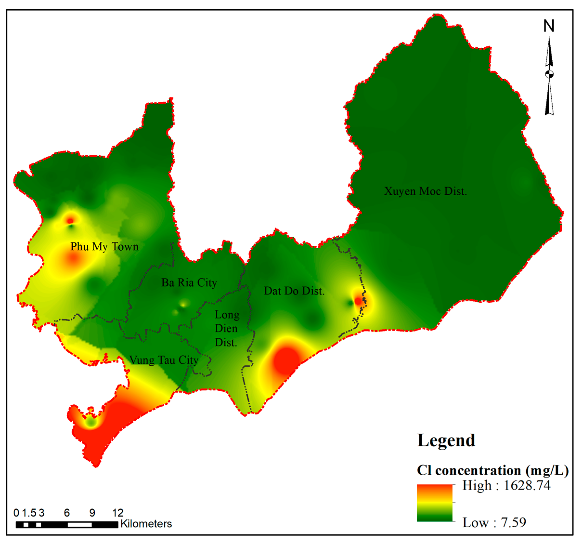
To assess the relevance and validity of the vulnerability zoning map, chloride concentrations were used to determine the impact of seawater on aquifer quality in the area. The spatial distribution of chloride according to the monitoring data in May 2021 varied from 7.59 to 1628.74 mg/L. Chloride values exceeding the National Technical Regulation limit of 250 mg/L were concentrated in the coastal area of Vung Tau City, the Dat Do district, and along the Thi Vai River, as shown in Figure 6, being similar to the zoning results obtained according to Entropy-GALDIT.

4. Discussion and Conclusions

The Pleistocene aquifer is one of the significant aquifers in the coastal area of Ba Ria-Vung Tau province that is affected by saline intrusion. The GIS-based GALDIT methodology framework was used to assess and identify vulnerable coastal aquifer areas with modified weighting by the Entropy method. This resulted in a visual document that can provide important information for managers to refer to in the process of permitting the exploitation or monitoring of seawater intrusion in the study area. Furthermore, the weights applied according to the Entropy method based on the variability of the hydrogeological features of area increased objectivity. This weighting method better reflects the height of the groundwater level above sea level, the distance from the shore, and the impact of the existing status of seawater intrusion into the regional aquifer.
The modified weighted vulnerability partition map of GALDIT in the GIS environment is more suitable than the original GALDIT method under the actual conditions of salinity in the study area in the context of climate change. The study area was divided into categories of low, medium, and high vulnerability, showing where saline intrusion has occurred, accounting for 40.65%, 55.47% and 3.88%, respectively. According to the results of the degree of vulnerability, the low vulnerability area was located between Long Dien District, Ba Ria City, Dat Do District, and the north of Xuyen Moc District. The most widely distributed medium vulnerability area was in the southeast and southwest of the study area and the rest of Phu My town, far from the coast. The southwest coast of Vung Tau City, the southeast region of Dat Do District, and along the Thi Vai River were highly vulnerable areas, where the height of the groundwater level was close to or below sea level, and the distance to the coastline was very close, leading to exposure to seawater intrusion. The results of the vulnerability map of the Pleistocene aquifer in the coastal area of Ba Ria-Vung Tau province can contribute to making management decisions to prevent groundwater pollution in the study area. It is required to restrict new construction and groundwater reclamation to avoid seawater intrusion into the aquifer. The current monitoring wells do not fully meet the need for salinity monitoring. Therefore, it is required to design a plan to monitor groundwater to serve the exploitation and efficient use of water sources.

Author Contributions

A.H.N. conducted the research, and revised and finalized the manuscript; K.Q.P. analyzed and collected the data; Q.H.L. revised and finalized the manuscript. All authors have read and agreed to the published version of the manuscript.

Funding

This research was funded by Vietnam National University Ho Chi Minh City (VNU—HCM), grant number C2022-24-01.

Institutional Review Board Statement

Not applicable.

Informed Consent Statement

Not applicable.

Data Availability Statement

The data presented in this study are available on request from the corresponding author. The data are not publicly available due to ethical considerations.

Conflicts of Interest

The authors declare no conflict of interest.

References

  1. Kazakis, N.; Busico, G.; Colombani, N.; Mastrocicco, M.; Voudouris, K. Limitations of GALDIT to map seawater intrusion vulnerability in a highly touristic coastal area. IOP Conf. Ser. Earth Environ. Sci. 2018, 191, 012050. [Google Scholar] [CrossRef]
  2. Chronidou, D.; Tziritis, E.; Panagopoulos, A.E.; Oikonomou, K.; Loukas, A. A Modified GALDIT Method to Assess Groundwater Vulnerability to Salinization—Application to Rhodope Coastal Aquifer (North Greece). Water 2022, 14, 3689. [Google Scholar] [CrossRef]
  3. Hussain, M.S.; Abd-Elhamid, H.F.; Javadi, A.A.; Sherif, M.M. Management of Seawater Intrusion in Coastal Aquifers: A Review. Water 2019, 11, 2467. [Google Scholar] [CrossRef]
  4. Werner, A.D.; Simmons, C.T. Impact of Sea-Level Rise on Sea Water Intrusion in Coastal Aquifers. Ground Water 2009, 47, 197–204. [Google Scholar] [CrossRef] [PubMed]
  5. Su, Z.; Wu, J.; He, X.; Elumalai, V. Temporal Changes of Groundwater Quality within the Groundwater Depression Cone and Prediction of Confined Groundwater Salinity Using Grey Markov Model in Yinchuan Area of Northwest China. Expo. Health 2020, 12, 447–468. [Google Scholar] [CrossRef]
  6. Chachadi, A.; Lobo-Ferreira, J. Sea water intrusion vulnerability mapping of aquifers using GALDIT method. Coastin 2001, 4, 7–9. [Google Scholar]
  7. Ferreira, A.; Chachadi, A. Assessing aquifer vulnerability to sea-water intrusion using GALDIT method: Part 2–GALDIT Indicators Description. In Proceedings of the 4th Inter Celtic Colloquium on Hydrology and Management of Water Resources, Guimarães, Portugal, 11–14 July 2005. [Google Scholar]
  8. Saravanan, S.; Parthasarathy, K.; Sivaranjani, S. Assessing coastal aquifer to seawater intrusion: Application of the GALDIT method to the Cuddalore Aquifer, India. In Coastal Zone Management; Elsevier: Amsterdam, The Netherlands, 2019; pp. 233–250. [Google Scholar]
  9. Kardan, M.H.; Jafari, F.; Javadi, S. Vulnerability evaluation of a coastal aquifer via GALDIT model and comparison with DRASTIC index using quality parameters. Hydrol. Sci. J. 2017, 62, 137–146. [Google Scholar]
  10. Mirzavand, M.; Ghasemieh, H.; Sadatinejad, S.J.; Bagheri, R.; Clark, I.D. Saltwater intrusion vulnerability assessment using AHP-GALDIT model in Kashan plain aquifer as critical aquifer in a semi-arid region. Desert 2018, 23, 255–264. [Google Scholar]
  11. Yang, J.; Tang, Z.; Jiao, T.; Malik, M.A. Combining AHP and genetic algorithms approaches to modify DRASTIC model to assess groundwater vulnerability: A case study from Jianghan Plain, China. Environ. Earth Sci. 2017, 76, 426. [Google Scholar] [CrossRef]
  12. Dweiri, F.; Kumar, S.; Khan, S.A.; Jain, V. Designing an integrated AHP based decision support system for supplier selection in automotive industry. Expert Syst. Appl. 2016, 62, 273–283. [Google Scholar] [CrossRef]
  13. Chakraborty, S.; Kumar, R.N. Assessment of groundwater quality at a MSW landfill site using standard and AHP based water quality index: A case study from Ranchi, Jharkhand, India. Environ. Monit. Assess. 2016, 188, 335. [Google Scholar] [CrossRef] [PubMed]
  14. Bozdağ, A. Combining AHP with GIS for assessment of irrigation water quality in Çumra irrigation district (Konya), Central Anatolia, Turkey. Environ. Earth Sci. 2015, 73, 8217–8236. [Google Scholar] [CrossRef]
  15. Han, Y.; Zhihong, Z. Water Quality Evaluation Based on Entropy Coefficient and Blind Number Theory Measure Model. J. Netw. 2014, 9, 1868–1874. [Google Scholar]
  16. Bo, M.; Aminreza, N.; Saman, J. Modification of the GALDIT framework using statistical and entropy models to assess coastal aquifer vulnerability. Hydrol. Sci. J. 2019, 64, 1117–1128. [Google Scholar]
  17. Jeong-Seok, Y.; Yong-Wook, J.; Amos, A.; Jin-Sik, S.; Jae-Boem, L. GALDIT Modification for Seasonal Seawater Intrusion Mapping Using Multi Criteria Decision Making Methods. Water 2022, 14, 2258–2277. [Google Scholar]
  18. Canh, T.T.; Thao, B.N.; Vuong, T.B. Assessment of aquifer vulnerability by saltwater intrusion in Tien Giang area by GALDIT method and proposion of a monitoring system for salt intrusion. J. Min. Earth Sci. 2018, 59, 71–83. [Google Scholar]
  19. Long, N.P.; Dat, T.H. Application of GIS-Base GALDIT for vulnerability assessment to saltwater intrusion of Holocene coastal aquifer: A case of Quang Nam-Da Nang city, Vietnam. Vietnam J. Earth Sci. 2020, 42, 298–310. [Google Scholar] [CrossRef]
  20. Pham, Q.N.; Ta, T.T.; Tran, T.L.; Pham, T.T.; Nguyen, T.C. Assessment of Saltwater Intrusion Vulnerability in the Coastal Aquifers in Ninh Thuan, Vietnam. Proc. EDESUS Glob. Change. Sustain. Dev. Asian Emerg. Mark. Econ. 2019, 2, 703–712. [Google Scholar]
  21. Nguyen, A.H.; Tuyet, N.P.T.; Hong, M.V.T.; Khanh, L.L.; Ngoc, T.T. Application of GIS-based GADLIT model for vulnerability assessment to seawater intrusion to Aquifer Upper-Middle Pleistocene in Phu My Town, Ba Ria-Vung Tau Province of Ba Ria-Vung Tau province. VNUHCM J. Earth Sci. Environ. 2021, 5, 37–46. [Google Scholar]
  22. Shannon, C.E. A mathematical theory of communication. Bell Syst. Tech. J. 1948, 17, 379–423. [Google Scholar] [CrossRef]
  23. Department of Natural Resources and Environment of Ba Ria-Vung Tau Province. Investigation and Assessment of Salinity in Aquifers due to the Impacts of Climate Change, Sea Level Rise in Coastal Areas of Ba Ria-Vung Tau Province; Department of Natural Resources and Environment of Ba Ria-Vung Tau Province: Ba Ria, Vietnam, 2020.
  24. Department of Natural Resources and Environment of Ba Ria-Vung Tau Province. Operation of Groundwater Monitoring Network in Ba Ria-Vung Tau Province; Department of Natural Resources and Environment of Ba Ria-Vung Tau Province: Ba Ria, Vietnam, 2021.
  25. Alqurnawy, L.S.; Almallah, I.A.; Alrubaye, A. Groundwater Vulnerability Analysis via GALDIT-GIS Method to Seawater Intrusion, South of Iraq. Iraqi Geol. J. 2022, 55, 147–162. [Google Scholar] [CrossRef]
  26. Department of Natural Resources and Environment of Ba Ria-Vung Tau Province. Research and Construction of Groundwater Monitoring Network in Ba Ria-Vung Tau Province; Department of Natural Resources and Environment of Ba Ria-Vung Tau Province: Ba Ria, Vietnam, 2011.
  27. Bordbar, M.; Neshat, A.; Javadi, S.; Pradhan, B.; Aghamohammadi, H. Meta-heuristic algorithms in optimizing GALDIT framework: A comparative study for coastal aquifer vulnerability assessment. J. Hydrol. 2020, 585, 124768. [Google Scholar] [CrossRef]
  28. Revelle, R. Criteria for recognition of sea water in ground-waters. Trans. Am. Geophys. Union 1941, 22, 593–597. [Google Scholar] [CrossRef]
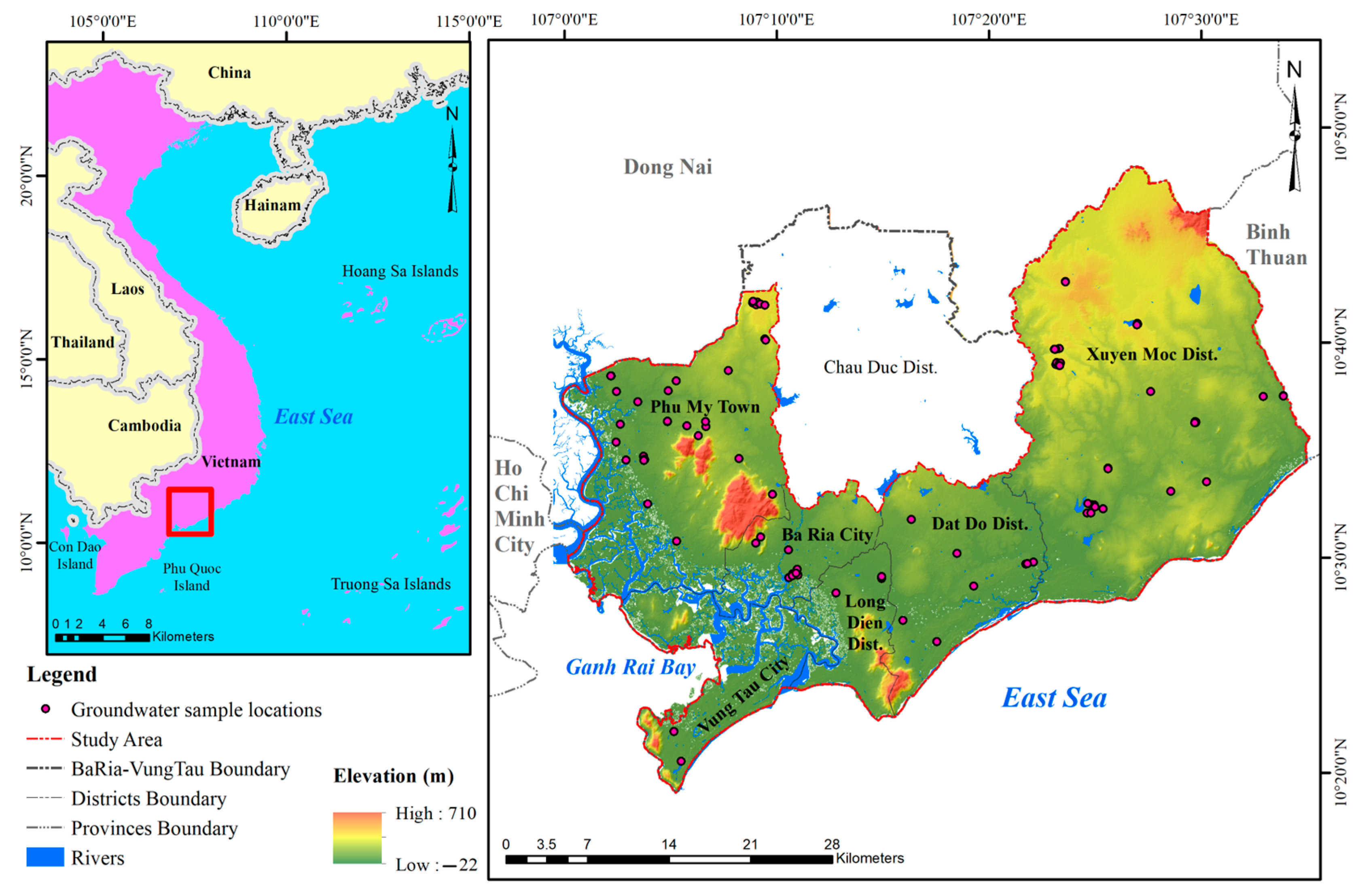
Figure 1. Location of the study area.
Sustainability 15 08107 g001
Figure 2. Hydrological cross-section for the study area.
Sustainability 15 08107 g002
Figure 3. Methodology for groundwater salinization vulnerability assessment in the coastal area.
Sustainability 15 08107 g003
Figure 4. Spatial distribution maps of six parameters of the GALDIT Index (a) Groundwater occurrence; (b) Aquifer hydraulic conductivity; (c) Height of groundwater level above sea level; (d) Distance from the shore; (e) Impact of existing status of seawater intrusion; (f) Thickness of the aquifer.
Sustainability 15 08107 g004
Figure 5. Vulnerability maps using different frameworks (a) GALDIT; (b) Entropy-weighted GALDIT.
Sustainability 15 08107 g005
Figure 6. Validation for Cl concentration.
Sustainability 15 08107 g006
Table 1. Classification standards according to GALDIT [7].
GALDIT ModelPartition Type
>7.5Low vulnerability zone
5–7.5Medium vulnerability zone
2.5–5High vulnerability zone
Table 2. Rating and weights of the parameters in the Entropy-GALDIT.
ParameterWeightRange/ExplanationRating
GALDITEntropy-GALDIT
G—Groundwater occurrence10.1653Confined aquifer10
Unconfined aquifer7.5
Leaky confined aquifer5
A—Aquifer hydraulic
conductivity (m/day)
30.1670>4010
10–407.5
5–105
<52.5
L—Height of groundwater level above sea level (m)40.1675<1.010
1.0–1.57.5
1.5–2.05
>202.5
D—Distance from the shore (m)40.1671<250010
2500–50007.5
5000–10,0005
>10,0002.5
I—Impact of existing status of seawater intrusion10.1674>2.010
1.5–2.07.5
1.0–1.55
<1.02.5
T—Thickness of the aquifer (m)20.1657>1010
7.5–107.5
5–7.55
<52.5
Disclaimer/Publisher’s Note: The statements, opinions and data contained in all publications are solely those of the individual author(s) and contributor(s) and not of MDPI and/or the editor(s). MDPI and/or the editor(s) disclaim responsibility for any injury to people or property resulting from any ideas, methods, instructions or products referred to in the content.