Article

A Protocol for Microclimate-Related Street Assessment and the Potential of Detailed Environmental Data for Better Consideration of Microclimatology in Urban Planning

by
Živa Ravnikar
1,*,
Alfonso Bahillo
2 and
Barbara Goličnik Marušić
3
1
Faculty of Engineering, University of Deusto, 48007 Bilbao, Spain
2
Department of Signal Theory and Communications, University of Valladolid, 47005 Valladolid, Spain
3
Urban Planning Institute of the Republic of Slovenia, 1000 Ljubljana, Slovenia
*
Author to whom correspondence should be addressed.
Sustainability 2023, 15(10), 8236; https://doi.org/10.3390/su15108236
Submission received: 28 February 2023 / Revised: 6 May 2023 / Accepted: 9 May 2023 / Published: 18 May 2023

Abstract

:
This paper presents a warning that there is a need for better consideration of microclimatology in urban planning, particularly when addressing microclimate-related human comfort in designing outdoor public spaces. This paper develops a protocol for microclimate-related street assessment, considering simultaneous dynamic environmental components data gathering and better understanding of microclimatic conditions when commuting by bicycle. The development of new information and communication technologies (ICTs) has the potential for overcoming the gap between microclimatology and urban planning, since ICT tools can produce a variety of soft data related to environmental quality and microclimate conditions in outdoor spaces. Further, the interpretation of data in terms of their applicability values for urban planning needs to be well addressed. Accordingly, this paper tests one particular ICT tool, a prototype developed for microclimate data collection along cycling paths. Data collection was performed in two European cities: Bilbao (Spain) and Ljubljana (Slovenia), where the main objective was the development of a protocol for microclimate-related street assessment and exploration of the potential of the collected data for urban planning. The results suggest that the collected data enabled sufficient interpretation of detailed environmental data and led to a better consideration of microclimatology and the urban planning of cycling lanes. The paper contributes to urban planning by presenting a protocol and providing fine-grained localised data with precise spatial and temporal resolutions. The data collected are interpreted through human comfort parameters and can be linked with rates/levels of comfort. As the collected data are geopositioned, they can be presented on a map and provide links between environmental conditions within a spatial context.

1. Introduction

Human comfort can directly be reflected in human behaviour, activity patterns, and the usage of space [1,2,3]. In this sense, microclimate consideration should be an integral part of designing outdoor public spaces when aiming to influence users’ behaviour to walk or cycle (more). Comfortable microclimate conditions can be achieved in different ways and with different levels of planning. For example, green infrastructure is usually correlated with a cooling effect and can mitigate the urban heat island effect [4,5,6], and architecture geometry and building height can influence wind speed [7,8] and flow and outdoor thermal performance [9]. Considering microclimate in designing spaces can lead to improvement in the environmental quality in and around places, as indicated, for example, by the implementation of various nature-based solutions (NBS) [10,11,12,13].
Thus, to influence the environmental conditions and address human comfort with spatial interventions, it is necessary to consider microclimate in actual urban planning and consider the climate outcomes in planning and decision-making processes. According to Ragheb et al. [8], the inclusion of climate analysis in the design process must be performed in its initial stages, before space is blocked off following uninformed decisions.
A literature review [14,15,16,17] reveals that in current urban planning practice, there are numerous challenges regarding the integration of microclimatological knowledge, which are reflected in:
  • The lack of microclimate consideration in urban planning;
  • The lack of collaboration and communication between climatologists, urban planners, and decision makers;
  • The lack of simultaneous and integrated microclimate parameter analysis in the form of climatological knowledge so that it can be easily integrated and interpreted in urban planning.
According to Smid and Costa [17], recommendations regarding how to implement climate data into urban planning remain holistic. Moreover, another challenge emphasised by Bherwani et al. [14] and Jänicke et al. [18] is related to the lack of simplified tools for analysing urban microclimates. By analysing today’s most common techniques to map microclimates (Section 2.3), we identified a significant gap in knowledge with regard to identifying microclimatic conditions at a pedestrian level. In this respect, this paper argues for better consideration of microclimate-related issues in urban planning, particularly through the appropriate collection of environmental data and their interpretation. Therefore, this paper presents the test results for one particular ICT tool to explore the urban-planning-related application potential of such collected data based on a protocol for microclimate-related street assessment, also developed as a supportive method for these tests. The protocol provides clear and transparent instructions, suggesting concrete actions urban planners/researchers could use to assess microclimate-related human comfort conduciveness in public spaces. This study sets up a frame for locally based environmental data collection, such as air temperature (°C), relative humidity (%), noise level (dBA), and particulate matter (PM 2.5 (µg/m3)). It also supports the objective analysis of this data. Such an analysis—identifying and interpreting environmental conditions—is recognised as having potential for the representation of a baseline for prioritising and selecting spatial interventions that may be needed to achieve or improve the quality of a space.

2. Background

Based on the identified gaps and the argument for better integration of urban planning and microclimatology, this section provides current insights regarding challenges related to the integration of microclimatological knowledge in urban planning (Section 2.1); the typology, role, and interpretation of data (Section 2.2); and current knowledge regarding techniques used to map microclimates (Section 2.3).

2.1. Challenges Regarding the Integration of Microclimatological Knowledge into Urban Planning

There has been substantial progress over the last decade in the field of urban microclimate research. However, this research has found limited application in urban planning practice [14,15,16,17,19,20,21]. There are seldom calls for better integration of these two disciplines, such as that of Yang et al. [21], who argue for pedestrian-friendly and climate-sensitive planning principles in urban infrastructure planning and public space system development. They consider paving the way for interrelated urban microclimate and urban planning aspects to be promising.
Similarly, Wong et al. [22] see the lack of climate consideration and usage of climatic mapping in urban planning as resulting from the fact that urban planning and urban climate research arose as different knowledge disciplines. Further, there are challenges related to policy frameworks, since urban microclimate aspects are currently being addressed only indirectly through different policy frameworks. When addressing microclimate-related human comfort in outdoor public spaces, regulatory documents are rarely prescriptive and mandatory; rather, they are presented in the form of recommendations. There is a need for more specific interrelation between the disciplines, an issue that was also recognised by Gehl [23], thereby emphasising so-called climate planning.
One of the main reasons for the limited application of microclimate studies in urban planning is related to the lack of performance of simultaneous analyses of all the factors that affect microclimate [14]. Although specific environmental parameters have been studied in detail (the urban heat island effect, air quality, etc.), microclimate conditions are a result of the dynamic connections among different microclimatic parameters. According to Bherwani et al. [14], microclimate parameter dependencies have been explored to a rather limited extent. Furthermore, Mills [24], addressing the incorporation of environmental objectives in urban plans at all scales, emphasises the need for applied climatology, where clear links between design decisions and climate outcomes would be considered in urban development processes and which would require a suitable form of climatological knowledge to be successfully integrated into urban planning.
In relation to bridging the implementation gap between disciplinary approaches and the shape of knowledge availability between urban planning and climatology, Lenzholzer et al. [16] indicate the need for improved communication and greater awareness of the possible implementable solutions among different actor groups, including urban planners and urban climate experts, but also politicians, policymakers, and citizens.

2.2. Data Interpretation for Better Consideration of Microclimatology and Microclimate-Related Human Comfort in Urban Planning: The Case of Cycling Lanes

Data interpretation is an essential part of incorporating microclimate considerations into urban planning. It enables planners and decision makers to make more informed decisions and is, therefore, crucial in urban planning processes, such as identifying places in which microclimatic conditions are uncomfortable and human comfort needs to be improved, running design processes that can optimise the design of places and buildings to increase the level of comfort, evaluating existing spatial solutions, and monitoring the efficiency of any introduced intervention. However, to interpret microclimate conditions for the purpose of urban planning, data characteristics play an important role, such as scale and resolution, to name two.
In designing outdoor public spaces, large scale is particularly important since it represents the scale on which the implementation of plan will be translated in the actual space. Large scales often refer to local, street, pedestrian, and human scales, where the exact metric units can vary. Understanding the scales at which urban planners operate with is important because of the provision of adequate details and the accuracy of the data required. Since designing cycling lanes usually takes place within medium- and large-scale planning documents, while being able to target users’ senses and stimuli, urban planners should work with fine-resolution data that reflect the environmental conditions people experience. Considering the fact that microclimate conditions can vary between 1 and 100 m [25], the suitability of microclimate-related data in urban planning would fit into spatial resolution that enables distinguishing environmental conditions with minimal accuracy of 100 m. However, optimal accuracy in terms of spatial resolution would be 10 m.
In addition to data spatial resolution, data temporal resolution is also important. Cycling in urban areas is considered either a leisure activity or a means of commuting. This indicates that cyclists occupy space at different time intervals during a day. Microclimate conditions also change within a 24 h period [25]. Therefore, data should reflect the environmental variability cyclists might experience in different time intervals in day, month, or a season. Another important aspect is that microclimate conditions are a result of dynamic connections among different microclimate parameters, and their mutual effects certainly affect human comfort. In this regard, when interested in environmental assessment in terms of human comfort, simultaneous and integrated analysis of all the factors that affect human comfort would be relevant in urban planning. Such data and analyses can help to assess places in terms of their environmental conditions and prioritise where and what kind of spatial interventions are required to achieve or improve the quality of a space.
In addition, there is also a practical aspect that pertains to the medium of mapping and the creation of maps, which are part of urban planning. Accordingly, Lin and Brown [26] argue that mapping microclimate data with spatial information is an effective means to link necessary information and present insights clearly. Building on this, this paper argues that, in urban planning, it is important to operate with graphically geolocated data in the form of maps, which enables the allocation of environmental data within a particular spatial context and supports better understanding of possible correlations between environmental conditions and spatial characteristics.

2.3. The Most Common Techniques Used to Map Microclimate

The following section describes the most frequently used techniques for the collection of environmental data. The techniques are commented on primarily in relation to the applicability of data in urban planning, where understanding large-scale, context-based information is crucial for creating or improving microclimate-related human comfort in outdoor spaces. The techniques are divided into three groups: (a) fixed weather station sensors, (b) remote sensing techniques, and (c) in situ measurements using different transportable devices, and are presented in the following sub-sections.

2.3.1. Fixed Weather Station Sensors

The most common technique by which cities obtain access to environment- and climate-related data is the so-called traditional observational technique, which depends on fixed weather stations situated across the city [27,28]. Since these stations are ground-based, the data can usually be interpreted only as the average values of environmental conditions for an entire city. However, the urban fabric within a city is heterogenic and diverse, and the microclimate conditions are locally specific and changeable. In this sense, static, single-point measurements are less appropriate to represent the heterogeneity and variability of urban spaces [29]. As has been mentioned, microclimatic conditions in built environments can vary between 1 to 100 metres [25]. Thus, when addressing the microclimate from a pedestrian level, we need to use techniques which can interpret microclimate conditions within a radius/accuracy of a few metres.

2.3.2. Remote Sensing Techniques

Data sets collected with remote sensing techniques are often the basis for various environmental analyses. However, remote sensing techniques are limited in terms of considering citizens’ comfort in a specific environment. Techniques that are based on transmitting light reflections from surfaces visible from the air can only display temperature related to a specific, more or less horizontal surface, and, because of the angles, they may be unable to capture the effects of vertical surfaces [30], such as the effect of shade under avenues of trees. In addition, remote sensing models should be treated with caution, as satellite-based observation data usually lack temporal resolution [29,30,31].
For example, NASA’s LandSat produces one image every 16 days at the same location—Ikonos every 11 days and Quickbird every 1–3.5 days [32]. However, the temporal scale of the urban microclimate, where local environmental conditions can be affected by different dynamic variables—for example, local weather and anthropogenic factors, such as traffic concentration—is usually less than 24 h or even a few seconds. Although certain satellites provide more frequent measurements, usually their sensors have limitations, such as spatial resolution limitations. Modis can provide a daily temporal resolution, but its spatial resolution is set to 250 m [33]. NOAA produces one image every few minutes, while its spatial resolution is 2 km. Sentinel-2, part of the Copernicus Programme, has a temporal resolution of an image every five days (under cloud-free conditions), with a 10 m spatial resolution [34]. In this sense, most of the spatial resolutions of remote sensing techniques do not allow full understanding of the detailed variability of spaces and their microclimate conditions [29,30,31].
The use of remote sensing techniques in microclimatology certainly has great potential, as with the advancement of technology—such as Lidar and other techniques operating with electromagnetic waves—it is now possible to increase the accuracy of data. However, these remote sensing processes are based on complex interactions between air and surfaces, and the data obtained from infrared images cannot be easily computed automatically due to their complexity [29]. On the other hand, the urban climate is dependent on a combination of locally based in situ dynamics; therefore, when assessing the urban microclimate, remote sensing techniques should be supported by bottom-up approaches.

2.3.3. In Situ Measurements and the Use of Different Transportable Devices

According to the overview of current techniques used to map a microclimate, there is a significant gap when it comes to identifying microclimatic conditions at a pedestrian level. The limitations of the existing methods call for and have led to the development of new innovations, such as using wearable devices to assess the urban microclimate at the pedestrian level.
Yadav and Sharma [35] examined the variation in intracity environmental conditions in Delhi, using the mobile transverse measurement technique. Meteorologically, the data were collected by mobile surveys, using HOBO data loggers installed on a vehicle. However, as monitoring was performed using a vehicle, this technique was limited to roads and did not consider other public spaces and paths where vehicular access is limited. Hu et al. [36] used an aerial–ground air-quality sensing system. It consists of Internet of Things (IoT) technology for the collection of fine-grained, real-time air-quality data, but it does not consider other microclimate parameters. Pigliautile and Pisello’s [37] research appears promising with respect to the issues addressed in this paper, as they proposed to analyse a heterogeneous urban space with a variety of microclimate parameters within the same city. They analysed location-specific environmental characteristics at a pedestrian level, using cluster analysis, based on data collected through mobile transects attached to a helmet.
Nakayoshi et al. [38] focused on data collection based on a unique wearable measurement system that measures a variety of thermal variables (e.g., ambient temperature, humidity, wind speed, and short-/long-wave radiation), along with certain physio-psychological parameters (e.g., skin temperature, pulse rate, subjective thermal sensation, and state of body motion). However, their contribution is oriented towards data products related to thermal physiology in subjects instead of assessing microclimate conditions in a city. Lau et al. [39] focused on the assessment of thermal comfort in high-density city variations and drew attention to the importance of the dynamic response of pedestrian thermal comfort under outdoor transient conditions. Their results revealed that urban geometry plays an important role in pedestrian thermal sensation. Zhang et al. [40] collected microclimate data using different meteorological transferable instruments: a mini temperature and humidity recorder, a solar radiometer, an anemometer, and a black globe thermometer, to define the outdoor thermal comfort of different sites in one park. Although their research did not include assessment of the level of noise and air quality, one of the benefits of their research is that they included the perceptions of people regarding human comfort. Studies such as that of Zhang et al. [40] have used procedures for assessing thermal comfort in urban spaces—the physiologically equivalent temperature (PET) index or the Universal Thermal Climate Index (UTCI). These methods are based on measuring environmental parameters and then applying the obtained data to the formula to gauge human comfort. Even though these methods enable the simultaneous measurement of different microclimate parameters, they can be challenging and expensive, as they require various pieces of equipment—a thermometer, a hygrometer, an anemometer, etc. Therefore, urban planners may need to collaborate with specialists, such as meteorologists, to obtain accurate measurements. Another limitation of such methods is their acquiring only static (yet transferable) and not dynamic measurements, and the data are not graphically presented on a map.
Xu et al. [41] focused on the temporal and spatial variability of microclimates and introduced a method for generating an urban climate map based on spatial statistical analysis of field measurement data (air temperature, relative humidity, and wind speed). The authors suggest that, with such an approach, urban planners can easily distinguish valuable urban climate zones to improve future development actions.
Another study worth mentioning was conducted by Fallast et al. [42]. They developed mobile sensors with GPS trackers which can be installed on bikes in public services. While attached to bicycles, the devices’ data can be used to interpret the variability of environmental conditions within different parts of the city. The authors emphasised the importance of temporal variation in localised climate conditions and that their device enables continual data collection over an extended period. However, they did not specify how often the device takes measurements and how precise the data’s spatial and temporal resolutions are. Another deficiency of the device in terms of the data’s representation of human comfort is that the tool includes only temperature and humidity sensors; other environmental sensors are not included.

2.4. Hypothesis Development

According to the literature review, emerging technologies incorporating various portable devices aim to assess the detailed spatial and temporal variations in urban climates with high precision; however, there is a lack of a comprehensive dynamic data collection technique for simultaneously obtaining data with characteristics applicable to urban planning that aims to provide comfortable cycling lanes. Moreover, there is a need for clear and transparent instructions suggesting concrete actions that urban planners could use to assess public spaces in terms of environmental conditions and human comfort.
In addressing the gap between microclimatology and urban planning, using ICT tools by developing clear instructions for data collection to obtain environmental data with characteristics applicable to urban planning, this paper proposes the following hypothesis: An integrated protocol for microclimate-related street assessment based on detailed, simultaneous dynamic environmental component data collection can represent an adequate approach to achieve improved consideration of microclimatological knowledge in the urban planning of cycling lanes.

3. Method

The method designed for this study consists of two levels. The first level is dedicated to data characteristics related to better consideration of microclimatology in the urban planning of cycling lanes. These characteristics refer to the quality of the data collected and are presented as criteria that create the background for the proposed protocol for microclimate-related street assessment.
Thus, the second level refers to the actual development of a protocol and its implementation and, therefore, also requires a testing methodology. The protocol was developed by considering the characteristics that are important in the urban planning of cycling lanes; it was tested on pilot cases related to commuter cycling in Ljubljana (Slovenia) and Bilbao (Spain), where the quality of data collected in accordance with the protocol was evaluated.

3.1. Data Characteristics for Better Consideration of Microclimatology in the Urban Planning of Cycling Lanes

The criteria were formatted with respect to two different aspects that are important when addressing microclimate comfort in the urban planning of cycling lanes (Figure 1). The first aspect is related to general characteristics of urban microclimates, while the second is related to data characteristics. By linking these two aspects, we proposed a set of criteria for data characteristics for better consideration of microclimatology in the urban planning of cycling lanes. The set of criteria is built upon the following related aspects: (a) human comfort, (b) human comfort zones, (c) spatial resolution, (d) temporal resolution, (e) simultaneous effects, and (f) mapping and mapmaking as a means of expression in urban planning.
The first criterion is human comfort. It defines that data must interpret microclimate conditions through microclimate-related human comfort parameters. Its definition was based on a literature review, where we identified which microclimate parameters affect human comfort. These are: (a) air temperature, (b) solar radiation, (c) humidity, (d) wind velocity, and (e) air quality. In addressing human comfort, we additionally paid attention to the following set of parameters: (f) level of noise, (g) human perception, and (h) other subjective parameters, such as human activity and clothing [34,43,44,45,46,47,48,49,50,51,52,53].
Obtaining and understanding of which parameters affect human comfort is important. However, in terms of urban planning, it is also important to interpret microclimate conditions through the level of spatial comfort. In this manner, urban planners can assess spaces and address microclimate improvement with so-called spatial solutions. Following from this, the second criterion is related to the interpretation of data on human comfort through human comfort zones. Based on the literature review, we defined certain comfort thresholds of the main microclimate parameters, referring to European climate zones and cultural and well-being contexts, a few of which are: (a) the thermal comfort zone proposed by the Universal Thermal Climate Index (UTCI) ranging between 9 and 26 °C (UTCI, n.d.), (b) noise levels above 60 dB being considered uncomfortable for having a conversation [1], (c) the upper threshold for fine particulate matter (PM 2.5) being 15 μg/m3 in one day [54], and (d) 30–65% humidity being considered comfortable for most people [55].
The third criterion is data spatial resolution. It is based on the literature review that indicates that microclimate conditions in relation to space can vary between 1 and 100 m [25]. Considering that urban planning involves different scales, data precision may play an important role. In this respect, to address the interpretation of microclimate conditions from a human perspective, the data spatial resolution must have a minimum accuracy of 10 m.
Further, the definition of temporal resolution is based on the literature review indicating that microclimate conditions in relation to time can change within a 24 h period [25]. Thus, it considers the time period in which cyclists occupy space while commuting. Thus, to address the interpretation of microclimate conditions from a human perspective, the data temporal resolution must indicate morning and afternoon periods.
Having covered all the basic aspects, a so-called cumulative aspect must be addressed, which reflects on the issue that the data collected must enable the comfort rating of simultaneous effects of various microclimate parameters. This criterion was based on the understanding that microclimate conditions are a result of dynamic connections among different microclimate parameters, their mutual effects influencing human comfort. Operating with data which enable the evaluation of space in terms of the simultaneous effects of microclimate parameters is beneficial in urban planning in terms of the simplified identification and prioritisation of spatial interventions that may be needed to achieve or improve the quality of spaces.
The final aspect (criterion) considered was the medium through which urban planning operates—that is, mapping and mapmaking. In order to achieve a better consideration of microclimatology in urban planning, the data must also be presented in the form of a map and must enable the linking of environmental conditions with a spatial context.

3.2. Protocol Development and Methodology for Testing

The development of a protocol for microclimate-related street assessment was based on a systematic process comprising the following key components:
  • Designing a step-by-step guide for assessing space in terms of microclimatic comfort to bring the climatology aspects closer to urban design analysis;
  • Considering the sampling strategy, to ensure the replicability of the protocol;
  • Identifying the necessary equipment; and
  • Developing the methodology for protocol testing, so the environmental street assessment can be applied in other cases.

3.2.1. Protocol Development

A step-by-step guide for assessing spaces in terms of microclimatic comfort is a tool that enables microclimate-related urban analysis. In such a process, it is crucial to limit the areas in which the analyses are performed. In this sense, we defined the set of steps to be considered: the definition of the measurement area; the selection of parameters to be measured and evaluated; the definition of measurement time intervals; and the analysis of the collected data, including visualisation of the results in the form of a map. These defined steps were used in the pilot testing. Their setting up in a pilot cases in Ljubljana (Slovenia) and Bilbao (Spain) is presented in Section 3.2.2, and the protocol steps implementation is discussed in the Results section.
The sampling strategy employed here focuses on commenting on the quality of the data collected and includes a plan for analysing the data to identify patterns and correlations among the data. In this sense, the sampling strategy is not defined in detail; however, illustrative examples of cycling lane sections were randomly defined and analysed.
Necessary equipment for the data gathering was also proposed. To obtain data that reflect microclimate conditions from a human perspective, we selected a tool that enables dynamic data collection from a bottom-up approach, with precise temporal and spatial resolutions. Since the tool serves well for dynamic data collection, a means of transport was also required. In addition, the appropriate speed of cycling (data collection) in relation to the frequency of the device’s data capturing was defined to enable precise data temporal and spatial resolutions.
The methodology for protocol testing refers to testing the clarity of the step-by-step guide and testing the usability of the protocol. Testing was set up to be performed in a pilot study related to commuter cycling in order to identify any issues or challenges that may arise during protocol implementation. The testing protocol is shown in detail in Section 4.1.

3.2.2. Methodology for Protocol Testing

To test the proposed protocol and assess the quality of the data collected, we performed protocol testing through pilot cases related to commuter cycling in Ljubljana (Slovenia) and Bilbao (Spain). Through individual protocol steps, we assessed the protocol setting and the data collected using the criteria of data characteristics for better consideration of microclimatology in the urban planning of cycling lanes.
1. Definition of the measurement area
In order to assess the usefulness of the protocol for data collection on cycling lanes in different parts of the city, the device must be tested in terms of its ability to enable dynamic data gathering.
The definition of the measurement area must be based on an analysis of the pilot case in terms of its spatial characteristics. The reason for this was to define an area that was sufficiently large to cover the variety of microclimatic conditions that occur within typologically diverse public spaces. Since a microclimate is influenced by various spatial characteristics, the following typologies of spaces must be included in such analyses: urban morphology, the type of place related to the usage of the place, and the type of place in terms of the presence of natural morphological elements.
2. Selection of parameters to be measured and evaluated
In this step, we tested the protocol in terms of enabling an interpretation of environmental conditions through human comfort parameters related to the microclimate: (a) air temperature, (b) solar radiation, (c) humidity, (d) wind velocity, (e) air quality, (f) level of noise, (g) and human perception or other subjective parameters. Data collection must be performed in different parts of the city and, thus, the versatility of microclimate parameters is included in the analysis.
In analysing the collected data, it is also necessary to identify the ability to interpret microclimate conditions through human comfort zones.
In case the data can be interpreted through comfort zones, a literature review must be conducted to identify the alignment of comfort zones with respect to European climate zones and cultural and well-being contexts.
3. Definition of measurement time intervals
Considering that microclimate conditions can change within 24 h and that commuting cyclists usually travel twice a day, it is necessary to test the protocol and the quality of data in terms of interpretation of the changeable microclimate conditions that cyclists experience in morning and afternoon intervals. In this step, the precision of data plays an important role. Data temporal resolution must be assessed in relation to the speed of cycling (data collection) and the frequency of data capture to interpret conditions in relation to the experience of cyclists.
4. Analysing the data collected
This step enables the identification of areas that are comfortable or uncomfortable for their users.
Since urban planning is mostly map-related, in this step, it was essential to test the medium in which the data were presented.
Moreover, creating a link between environmental conditions and a spatial context plays an important role, so the precision of data in terms of spatial resolution must be assessed. This must be performed by analysing collected data in combination with a base map and satellite images to identify the ability to interpret conditions within at least 10 m.
Finally, it is necessary to test the characteristics of data in terms of comfort rating interpretation and the simultaneous effects of parameters. This is carried out by collecting data on cycling lanes, where possible extreme microclimate conditions could occur and synergies would affect cyclists’ comfort levels.

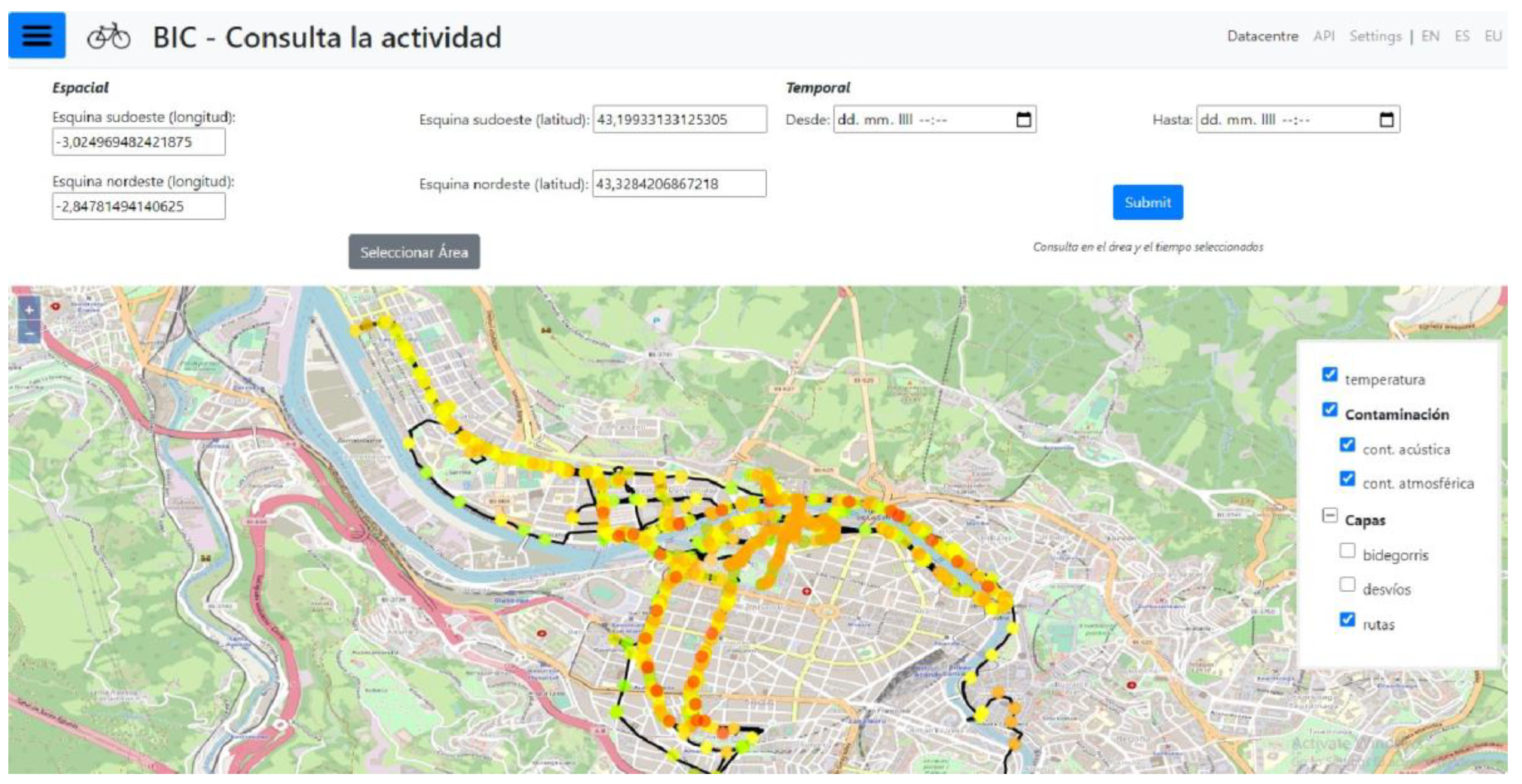
3.3. Presentation of the Tool

The tool selected for this research was developed by the University of Deusto in Bilbao, Spain. Its main purpose is to collect and analyse detailed and locally based microclimate-related data at a user-experience level. The tool consists of two main components: hardware (Figure 2 and Figure 3) and software. The hardware consists of sensors for the simultaneous collection of environmental data: air temperature (°C), relative humidity (%), noise level (dBA), and particulate matter (PM 2.5 (µg/m3)).
The hardware is connected to a user interface (software), a platform—Bike Intelligent Centre—which provides feedback to the user and is publicly accessible at http://bizkaiabikeintelligence.deustotech.eu/en/datacentre (accessed on 10 April 2022) (Figure 4). The platform enables a variety of functions for analysing different microclimate parameters. The tool does not allow the calculation of comprehensive indices (such as thermal comfort and heat stress indices, such as PET, UTCI, and SET) and does not provide information about the overall effects of the thermal environment on the human body. However, the tool enables the measurement of each of the mentioned parameters and then displays environmental data on a map using different colours to represent each parameter. The colours are based on threshold classification, in which different colours represent different levels of data values.
The tool also enables the tracking of movement, which is represented by a track on the platform. The query function enables the selection of specific date and time intervals of interest for analysis. The platform also consists of an underlying spatial map, which provides basic information, such as land use and the level of occupation of bicycle paths (Figure 5), which—with the combination of all platform features—enables a better interpretation of the collected data.

4. Analyses and Results

In this section, the results of the protocol testing are presented. In the first part, the practical performance of the protocol is presented as part of the analysis of the pilot cases in Ljubljana (Slovenia) and Bilbao (Spain) with respect to the quality of the data collected. In the second part, we explore and define the potential of such detailed environmental data in urban planning, using the criteria for data characteristics for better consideration of microclimatology issues in the urban planning of cycling lanes.

4.1. Protocol for Microclimate-Related Street Assessment

Data collection was performed in two European cities: Bilbao (Spain), with approximately 348,000 inhabitants, and Ljubljana (Slovenia), with approximately 293,822 inhabitants. In terms of climate conditions, Bilbao has an oceanic climate, with mild winters and warm summers. Ljubljana, by contrast, has a continental climate, with cold winters and warm summers. In both cities, the weather is most stable in the warmer months of the year, which usually encourages people to cycle as part of their daily routines. Since the research is focused on the testing of the protocol, data collection was performed only within a couple of months (from June to September); however, to perform a more comprehensive microclimate analysis, additional months should be taken into account (late-spring and late-autumn months).
1. Definition of the measurement area
Data collection was performed on cycling lanes that have a high cycling occupancy level according to Ljubljana’s stationary cycling counters’ data. On the other hand, in Bilbao, we focused on the official urban cycling lanes, which, according to the municipality, encourage active mobility among Bilbao residents.
Cycling lanes lead through different parts of the city (Figure 6), where a variety of place characteristics are evident. According to a land-use plan, the cycling paths most often crossed residential areas, green spaces, and areas of central activities. With respect to city morphology, the paths led through different urban structures, such as a densely built-up historic urban area, a densely built-up urban area, and a relatively compact urban pattern with areas of low density. The most common natural morphological features were found to be flat terrain, open spaces, and artificial non-agricultural green areas, such as urban tree lines and small-sized green surfaces. The results of testing suggest that a tool’s portability and autonomy enable data collection from all publicly accessible outdoor areas.
2. Selection of parameters to be measured and evaluated
The parameters were selected in accordance with the focus of this research; we were interested in microclimatic conditions that affect human comfort. We selected air temperature (°C), relative humidity (%), barometric pressure (kPa), particulate matter (PM 1.0, PM 2.5, and PM 10.0 (µg/m3)), CO2 gas, and noise level (dBA), since the commuter cycling lanes in both cities are characterised by proximity to road traffic. Cyclists in Ljubljana and Bilbao usually do not occupy streets in winter months and rainy days; thus, microclimatic variables, such as rainfall, snowfall, and frost, were excluded from the protocol.
Within the protocol, performing simultaneous collection of dynamic environmental data components, we were able to interpret data within the range of human comfort zones, with varying colours indicating the threshold classification of these zones. The classification was based on a Spanish and European environmental context; however, the threshold zone limits can be adjusted and used within different climate contexts (Table 1).
Currently, with the device we used, it is possible to collect data for all the selected parameters; however, the ICT is still a prototype and, thus, the platform currently enables the display of only the following parameters: air temperature, relative humidity, particulate matter (PM 2.5), and noise level. Other parameters have been included in the tool and are being collected with the tool’s USB card.
Comfortable threshold zones (bolded columns in Table 1) proposed within a platform are more or less aligned with the values that are, according to the literature, comfortable in European climate zones and cultural contexts: the thermal comfort zone proposed by the Universal Thermal Climate Index (UTCI), which ranges between 9 °C and 26 °C (UTCI, n.d.); noise levels above 60 decibels are considered uncomfortable for having a conversation [1]; the upper threshold for fine particulate matter (PM 2.5) is 15 μg/m3 in one day [54]; and 30–65% humidity is considered comfortable for most people [55].
Here, we must emphasise again that this tool does not enable a final assessment of human comfort with a comprehensive index, and the only reason we are mentioning the UTCI is to reference the thermal comfort zones for indexing proposes.
3. Definition of measurement time intervals
We were interested in the conditions under which people cycle to commute, which is defined as travelling from home to a place of work or study. The time intervals were set in accordance with working days (Monday to Friday), in the mornings from 7:30 to 9:00 and in the afternoons between 15:00 and 17:30.
Within these time periods, the tool enabled us to collect data every 5 s, thereby allowing for precise data temporal resolution. However, findings suggest that such detailed data collection accuracy needs to be harmonised with an appropriate speed of data collection (see Section 4.2.1).
4. Analysing the collected data
The protocol enables the evaluation of streets in terms of current microclimate conditions. The results of the data collection are presented with a map-based platform that enables, with precise data spatial resolution, the linkage of microclimatic conditions with spatial contexts. The results suggest that, with the protocol and the data collected, it is also possible to assess space in terms of different levels of comfort.
The protocol, using a dynamic tool, enabled us to collect and interpret microclimate conditions through comfort zones, thereby indicating that the temperature in both cycling lanes was slightly above the human comfort zone (Figure 7). The comfortable temperature and low noise levels on the left cycling lane could be correlated with several spatial elements, including a row of trees, an unpaved surface, and the physical orientations of nearby buildings, which provided additional shade. However, the humidity level on the left cycling lane was slightly higher, ranging from 58.09% to 59.93%, compared to that in the right lane, which ranged from 54.85% to 56.15%. The air-quality data in the proximity of the green elements in the left cycling lane ranged from 23.50 µg/m3–25.00 µg/m3, while on the right side, the values were higher at 23.00 µg/m3–28.50 µg/m3. Since the measurements on both sides were taken approximately half an hour apart, the comparison of cycling lanes was only made for demonstration. However, when we want to compere different locations in detail, controlled climatic data must be included. Such an analysis illustrates the primary purpose of using the protocol and ICT and shows the manner of evaluating the space from the perspective of microclimate comfort. However, to provide a full-fledged analysis, more repetitions must be performed. This refers particularly to parameters of air quality and level of noise, where one-time measurements at a given moment for a fraction of a second are not representative.

4.2. Exploring the Potential of Detailed Environmental Data for Urban Planning

In the following sub-section, data collected according to the proposed protocol are evaluated using criteria of data characteristics for better consideration of microclimatology in the urban planning of cycling lanes. The results indicate the quality of data, ranging from data spatial and temporal resolutions, the characteristics of the data in relation to interpretation within human comfort zones, the rating of human comfort, and, finally, mapmaking ability.

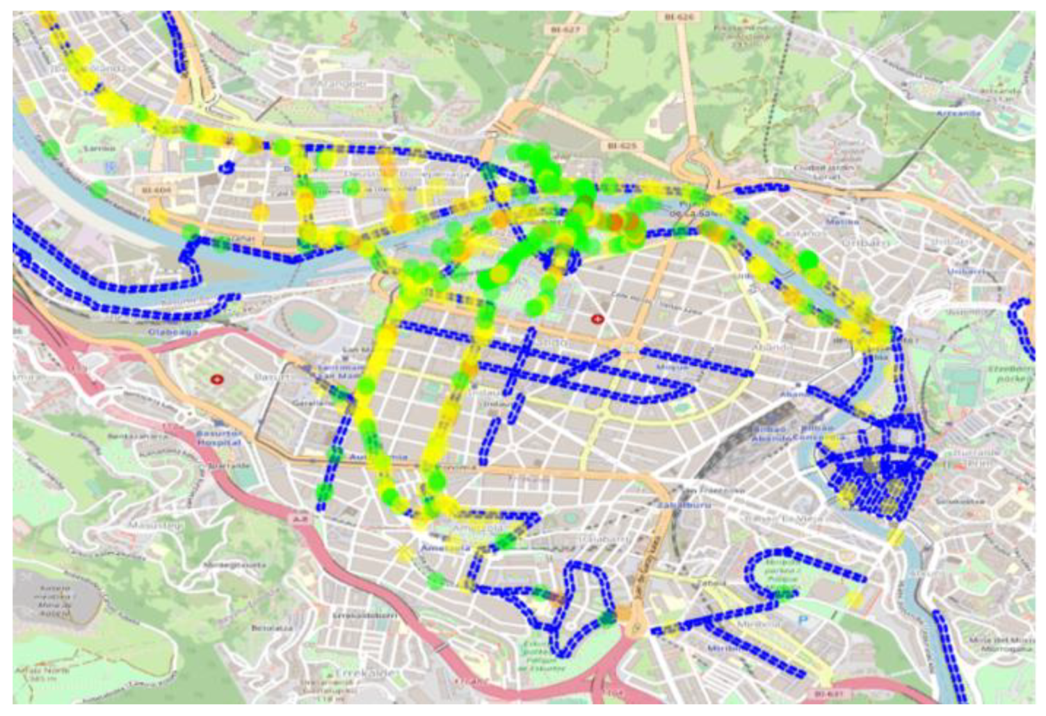
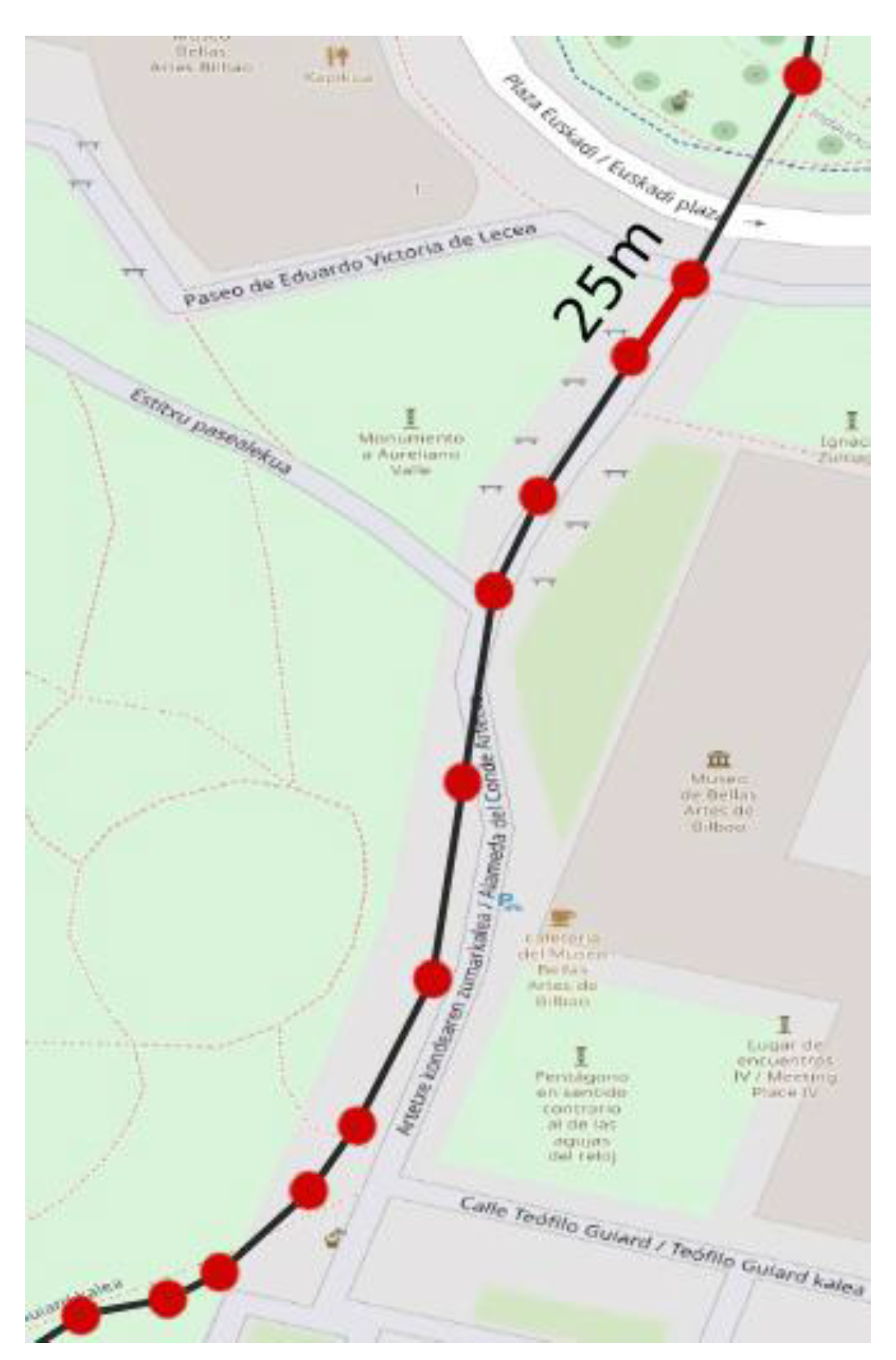
4.2.1. The Data Spatial Resolution of the Tool

Planning cycling routes usually requires medium- and, most importantly, large-scale planning, where targeting users’ senses and stimuli requires fine-resolution data. Since microclimate conditions can vary between 1 m and 100 m [25], the data obtained within the protocol were evaluated in terms of accuracy of spatial resolution.
Within this research, data collection was performed using a bicycle, moving at approximately 18 km/h, and the device took measurements at five-second intervals. With regard to the speed of cycling, the device took measurements every 25 m (Figure 8). Following the protocol and using the ICT tool, it was possible to obtain data that were sufficiently precise in terms of spatial resolution; however, to obtain more detailed data, the appropriate speed of data collection must be addressed. To achieve data collection every 10 m, the speed must be reduced to 7 km/h. Such detailed data acquisition enables the performance of analyses, particularly for urban areas, where urban planners usually operate with limited spaces.

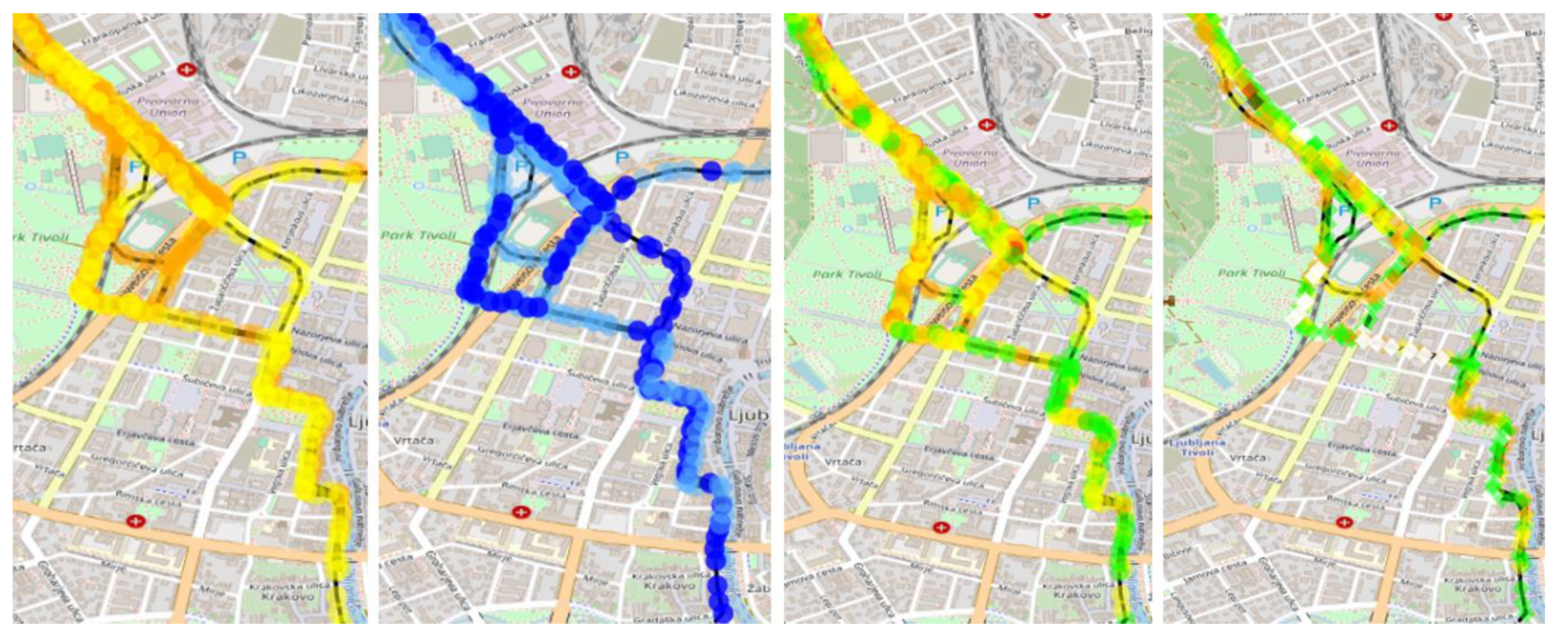
4.2.2. The Interpretation of Environmental Conditions through Human Comfort Parameters

The device enabled the collection of data for the following parameters: air temperature, relative humidity, noise level, and particulate matter (PM 2.5), which represents the potential for a more comprehensive understanding of environmental conditions in a particular area. The inclusion of these parameters is sufficient to understand the environmental conditions from an objective–numerical standpoint, which address only the physical conditions. The application value of such data is seen in performing analyses in urban areas to identify environmental challenges with respect to high temperatures, air quality, humidity, and noise levels.
For illustration, an environmental street assessment was performed in Ljubljana between June and September 2021 on one of the busiest cycling lanes in the city centre (Figure 9).

4.2.3. Comfort in Places

The protocol and the dynamic tool proved capable of providing data, allowing the interpretation of environmental conditions within different levels of comfort zones (see the Table 1).

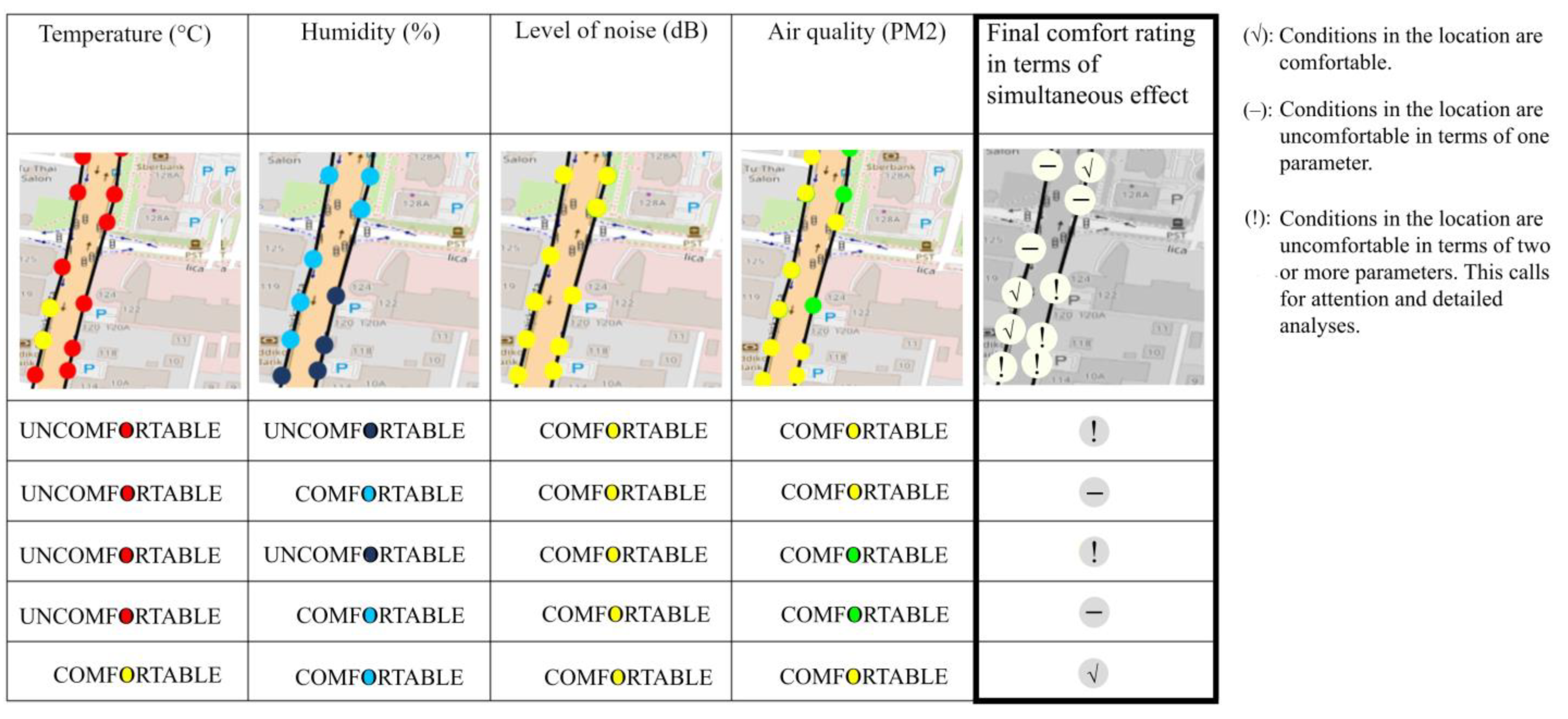
4.2.4. Potential for Comfort Rating in Terms of Simultaneous and Integrated Analysis of Microclimate-Related Comfort Parameters

ICT tools have the potential to collect and analyse site-specific information; however, the interpretation of data related to the needs of urban planning is crucial. Data collection using the proposed protocol enabled us to present the results of the analysis not only via quantified results but also through an interpretation that could support urban planning decision processes. The tool’s platform provides a graphical display of space evaluation in terms of the simultaneous influences of parameters: air temperature (°C), relative humidity (%), particulate matter (PM 2.5 (µg/m3)), and noise level (dBA), where different symbols indicate the locations that need to be examined in more detail and which possibly require spatial interventions.
The following example (Figure 10) provided for illustration suggests that if the conditions of a location are comfortable in terms of all four parameters, the final evaluation is to be marked with the symbol ‘√’. Such a location has comfortable microclimatic conditions and probably does not need spatial microclimatic improvement. If the conditions in the location are uncomfortable in terms of one parameter, the final evaluation is marked with the symbol ‘−’, which indicates that the location needs to be analysed in detail and examined for possible spatial intervention. However, if a location’s conditions are uncomfortable in terms of two or more parameters, the location is marked with an exclamation mark, ‘!’, and calls for attention. Such comfort ratings in terms of simultaneous and integrated analysis of the microclimate have added value in terms of the simplified identification and prioritisation of environmental challenges; however, in urban planning, it is always necessary to analyse a location’s specifics in detail and assess a space in terms of other variables (such as the size of the uncomfortable area, the occupancy of space, the type of place related to the usage of space, morphology, etc.).

4.2.5. The Tool’s Temporal Resolution Data

Since microclimatic conditions can change within a 24 h period [25] and since commuting cyclists travel at least twice per day, the minimum time intervals required for identifying microclimate conditions that cyclists experience were defined in terms of morning and afternoon intervals. The protocol and the tool enabled the collection of data every five seconds in any time period for one day. The results suggest that the applicable value within urban planning is obtained by performing an environmental analysis of identifying environmental conditions that cyclists experience. Even though data collection was performed in the months between June and September, the results led us to conclude that the tool, given its characteristics, has the potential to be used over longer time periods and thus enable the analysis of conditions that change with the seasons as well. The potential of such detailed data can also be seen in the monitoring of spatial-solution impact areas, such as NBS, in which environmental conditions can vary within a couple of hours or a couple of years.

4.2.6. Mapmaking and Linking Environmental Conditions with Spatial Contexts

The tool enables the collected data to be displayed on a map-based platform, where all the collected environmental data are geolocated. The platform consists of an underlying spatial map, considering basic information related to land use, which allows a researcher to better understand and interpret the collected data. In this sense, the tool’s data proved applicable in terms of enabling a graphical representation of the map-based data, which represents a medium which urban planners can use to better understand correlations between environmental conditions and spatial characteristics.

5. Study Limitations

The first limitation of this study is related to the parameters that were included in the protocol and the analyses of the pilot cases in Ljubljana and Bilbao. Certain authors argue that the term ‘comfort’ in relation to air characteristics is mainly linked to the absence of odour or personal sensory irritation [43]; thus, this parameter could be additionally included in the protocol. This limitation also implies another subjective parameter—an individual’s perception is a complex parameter, which is affected by psychological adaptation, preferences, culture, climate-zone acclimatisation, and physical activity [44,45,46,47,48,49]. This parameter is important when evaluating microclimate comfort and would add additional value to the research. Quantitative, numerical environmental data, in combination with individuals’ subjective perception outputs, represent a basis for identifying the actual human comfort people experience in specific socio-spatial contexts. However, this tool focuses only on objectively measured environmental human comfort data that urban planners can analyse when assessing environmental conditions in different physical spatial settings. Another limitation regarding the parameters is related to the platform’s ability to analyse and visually display data. Since the tool is still a prototype at this point, it only allows graphical representation of the following parameters: air temperature, relative humidity, particulate matter (PM 2.5), and noise level, while other parameters (barometric pressure (kPa), particulate matter (PM 1.0 and PM 10.0 (µg/m3)), and CO2 gas), which were installed additionally, must be analysed manually after being collected and stored on the USB card of the tool.
Further, there is another limitation with regard to the ICT’s current feature: at this point, the tool is able to interpretate data through ’comfort zones’ and through the evaluation of ‘final comfort in terms of a simultaneous effect’. However, microclimate conditions are a result of dynamic connections among microclimatic parameters, while their mutual effects influence human comfort as well. In this sense, the mutual parameter effects would add additional value in terms of data interpretation.
The next limitation of this study is related to the quantity of sampling. The period of data collection was limited to June to September and, thus, does not represent a full-fledged investigation of the microclimate conditions of Bilbao’s and Ljubljana’s cycling lanes. However, the focus of this study was not a detailed microclimatic analysis, but the design of a protocol and its testing, with the usage of ICT, in order to produce data that aid in urban planning.

6. Discussion

This paper warns that there is a gap between microclimatology and urban planning and explores the potential of a protocol setting for microclimatic street assessment through the production of detailed data that can be used to overcome that gap. By analysing the most common current techniques to map microclimate, we identified a significant gap when it comes to identifying microclimatic conditions at a pedestrian level. With the development of new technologies, different transportable devices are emerging to assess microclimate-related human comfort in outdoor public spaces. Pigliautile and Pisello [37] analysed site-specific environmental characteristics at a pedestrian level, using cluster analysis, based on data collected through mobile transects attached to a helmet. Hu et al.’s [36] study, based on an aerial–ground air-quality sensing system, shows the potential for the production of fine-grained air-quality data. Yadav and Sharma [35] examined the variation in intracity environmental conditions using the mobile transverse measurement technique. Nakayoshi et al. [38] measured not only environmental variables but also included physio-psychological parameters, such as skin temperature, thermal sensation, and state of body motion. Zhang et al. [40] defined outdoor thermal comfort in different park setting scenes, using static measuring tools to define the UTCI and PET indices. In addition, Fallast et al. [42] developed a dynamic tool to assess the variability in environmental conditions in different parts of a city.
Each of these studies contributes to the development of bottom-up approaches and represents a step toward a better understanding of the relationship between microclimates and the users of spaces. However, there is a lack of a comprehensive dynamic data collection technique for simultaneously obtaining detailed data with characteristics applicable to urban planning. Moreover, there is a need for clear and transparent instructions that suggest concrete actions that urban planners could use to assess public spaces in terms of microclimatic comfort. Given this background, we developed we developed a protocol for microclimatic street assessment, using simultaneous dynamic environmental components data gathering and examined its value for better consideration of microclimatology in urban planning. The results of the protocol testing suggest that the protocol which employs a particular ICT tool enabled the production of detailed data, where the potential of such data was mostly seen in conducting urban planning analyses of environmental conditions from the perspective of human comfort. The collected data successfully addresses the challenge related to spatial resolution. Due to the tool’s portability and autonomy, it enabled data collection from all publicly accessible outdoor areas, and the spatial resolution of the data was sufficiently detailed to represent variable microclimate conditions within a few meters. Regarding the data’s temporal resolution, the protocol and the tool enabled the collection of data every five seconds in any time period within one day. Considering that microclimate conditions change within a 24 h period [25], the data are sufficiently detailed to identify changeable conditions that commuting cyclists experience in morning and afternoon travel intervals. Our results indicate that the collected data can be interpreted through different microclimatic parameters and individual comfort zones pertaining to space. The platform of the tool provides a graphical display of space evaluation as well in terms of the simultaneous effect of the influence of parameters, with different symbols indicating which locations need to be examined in more detail and possibly addressed with spatial interventions. Finally, there is also a practical aspect—the medium in which the data are presented and which is directly related to the improvement of the communication between microclimatology and urban planning; the data are presented in a graphical map-based display, which is a medium which urban planners operate with. With such data characteristics and interpretation, the tool enables a researcher to better understand the possible correlations between environmental conditions and specific spatial elements, solutions, or city structures. The platform also enables an easy step to perform environmental assessment analysis, which can also be conducted by a non-ICT expert.
The implications of the protocol and such detailed data are evident for urban analyses aiming to identify microclimatic comfort conditions in cycling lanes. By interpreting such detailed data, urban planners can assess spaces in terms of the level of comfort or discomfort and can identify possible environmental challenges. Such urban analyses are recognised as having potential in representing the baseline for prioritising and selecting spatial interventions that may be needed to improve the quality of a space.

7. Conclusions

Cities are increasingly responding to challenges related to climate change and are adapting urban planning to improve the environmental quality of spaces, where human comfort plays an important role.
However, traditional urban analyses may be insufficient for fully analysing the interactions between environmental characteristics, microclimate conditions, and human comfort.
The emergence of new technologies in the field of ICT represents a potential for more comprehensive analyses, yet the data produced must be assessed in terms of the parameters that are applicable in urban planning.
In this research, we developed a protocol for microclimate-related street assessment, using data collection of simultaneous dynamic environmental components, and examined their value in obtaining detailed microclimate data. The results of testing revealed that the protocol using a particular ICT tool enabled the production of data with characteristics that support better consideration of microclimatology in urban planning. The data collected have precise temporal and spatial resolutions which enable the identification of variable microclimate conditions within a few meters, every five seconds. In terms of data characteristics related to comfort, the results indicate that the data can be interpreted through the following microclimate parameters: air temperature, relative humidity, particulate matter (PM 1.0, 2.5, and 10.0 (µg/m3)), noise level, barometric pressure (kPa), and CO2 gas, thereby indicating the comfort assessment of space. The findings also suggest that the data are presented through a map-based visual representation of spatial assessment, considering the simultaneous effects and influences of different parameters.
With the development of a protocol for obtaining microclimatic data, the paper successfully addresses the identified gap in terms of enabling the interpretation of microclimate conditions from the perspective of human comfort, which represents an adequate approach to achieving improved consideration of microclimatology in the urban planning of cycling lanes.

Author Contributions

Ž.R. (Conceptualization, Writing—original draft preparation, Investigation, Methodology), A.B. (Review, Supervision) and B.G.M. (Writing—review & editing, Supervision). All authors have read and agreed to the published version of the manuscript.

Funding

This project has received funding from the European Union’s Horizon 2020 Research and Innovation Programme under the Marie Skłodowska-Curie grant agreement Nº 847624. In addition, a number of institutions back and co-finance this project. This paper reflects only the author’s view and the Research Executive Agency is not responsible for any use that may be made of the information it contains. The authors acknowledge the financial support from the Slovenian Research Agency (research core funding No. P5-0100). This research was partially supported by the Spanish Ministry of Science and Innovation under the PeaceOfMind project (ref. PID2019-105470RB-C31).Sustainability 15 08236 i001

Institutional Review Board Statement

Not applicable.

Informed Consent Statement

Not applicable.

Data Availability Statement

Not applicable.

Conflicts of Interest

The authors declare no conflict of interest.

References

  1. Gehl, J. Life between Buildings, 6th ed.; Island Press: Washington, DC, USA, 2011. [Google Scholar]
  2. Lin, T. Thermal perception, adaptation and attendance in a public square in hot and humid regions. Build. Environ. 2009, 44, 2017–2026. [Google Scholar] [CrossRef]
  3. Thorsson, S.; Lindqvist, M.; Lindqvist, S. Thermal bioclimatic conditions and patterns of behaviour in an urban park in Göteborg, Sweden. Int. J. Biometeorol. 2004, 48, 149–156. [Google Scholar] [CrossRef] [PubMed]
  4. Aram, F.; Higueras García, E.; Solgi, E.; Mansournia, S. Urban green space cooling effect in cities. Heliyon 2019, 5, e01339. [Google Scholar] [CrossRef] [PubMed]
  5. Ghosh, S.; Kumar, D.; Kumari, R. Assessing spatiotemporal variations in land surface temperature and SUHI intensity with a cloud-based computational system over five major cities of India. Sustain. Cities Soc. 2022, 85, 104060. [Google Scholar] [CrossRef]
  6. Reis, C.; Lopes, A. Evaluating the cooling potential of urban green spaces to tackle urban climate change in Lisbon. Sustainability 2019, 11, 2480. [Google Scholar] [CrossRef]
  7. Du, T.; Jansen, S.; Turrin, M.; van den Dobbelsteen, A. Effects of Architectural Space Layouts on Energy Performance: A Review. Sustainability 2020, 12, 1829. [Google Scholar] [CrossRef]
  8. Ragheb, A.A.; El-Darwish, I.I.; Ahmed, S. Microclimate and human comfort considerations in planning a historic urban quarter. Int. J. Sustain. Built Environ. 2016, 5, 156–167. [Google Scholar] [CrossRef]
  9. Mahmoud, H.; Ghanem, H.; Sodoudi, S. Urban geometry as an adaptation strategy to improve the outdoor thermal performance in hot arid regions: Aswan University as a case study. Sustain. Cities Soc. 2021, 71, 102965. [Google Scholar] [CrossRef]
  10. EC—European Commission. Evaluating the Impact of Nature-Based Solutions: A Handbook for Practitioners; The Publications Office of the European Union: Luxembourg, 2021; Available online: https://data.europa.eu/doi/10.2777/244577 (accessed on 9 November 2021).
  11. Dumitru, A.; Frantzeskaki, N.; Collier, M. Identifying principles for the design of robust impact evaluation frameworks for nature-based solutions in cities. Environ. Sci. Policy 2020, 112, 107–116. [Google Scholar] [CrossRef]
  12. Goličnik Marušić, B.; Dremel, M.; Ravnikar, Ž. A frame of understanding to better link nature-based solutions and urban planning. Environ. Sci. Policy 2023, 146, 47–56. [Google Scholar] [CrossRef]
  13. Mosca, F.; Dotti Sani, G.M.; Giachetta, A.; Perini, K. Nature-based solutions: Thermal comfort improvement and psychological wellbeing, a case study in Genoa, Italy. Sustainability 2021, 13, 1638. [Google Scholar] [CrossRef]
  14. Bherwani, H.; Singh, A.; Kumar, R. Assessment methods of urban microclimate and its parameters: A critical review to take the research from lab to land. Urban Clim. 2020, 34, 100690. [Google Scholar] [CrossRef]
  15. Eliasson, I. The use of climate knowledge in urban planning. Landsc. Urban Plan. 2000, 48, 31–44. [Google Scholar] [CrossRef]
  16. Lenzholzer, S.; Carsjens, G.-J.; Brown, R.D.; Tavares, S.; Vanos, J.; Kim, Y.; Lee, K. Awareness of urban climate adaptation strategies—An international overview. Urban Clim. 2020, 34, 100705. [Google Scholar] [CrossRef]
  17. Smid, M.; Costa, A.C. Climate projections and downscaling techniques: A discussion for impact studies in urban systems. Int. J. Urban Sci. 2018, 22, 277–307. [Google Scholar] [CrossRef]
  18. Jänicke, B.; Milošević, D.; Manavvi, S. Review of user-friendly models to improve the urban micro-climate. Atmosphere 2021, 12, 1291. [Google Scholar] [CrossRef]
  19. European Environmental Agency (EEA). Urban Adaptation to Climate Change in Europe 2016—Transforming Cities in a Changing Climate; EA Report No. 12/2016; European Environmental Agency: Copenhagen, Denmark, 2016; Available online: https://www.eea.europa.eu/publications/urban-adaptation-2016 (accessed on 9 November 2021).
  20. Stewart, I.D.; Oke, T.R. Local climate zones for urban temperature studies. Bull. Am. Meteorol. Soc. 2012, 93, 1879–1900. [Google Scholar] [CrossRef]
  21. Yang, L.; Zhang, L.; Stettler, M.E.; Sukitpaneeni, M.; Xiao, D.; van Dam, K.H. Supporting an integrated transportation infrastructure and public space design: A coupled simulation method for evaluating traffic pollution and microclimate. Sustain. Cities Soc. 2020, 52, 101796. [Google Scholar] [CrossRef]
  22. Wong, N.H.; Jusuf, S.K.; Tan, C.L. Integrated urban microclimate assessment method as a sustainable urban development and urban design tool. Landsc. Urban Plan. 2011, 100, 386–389. [Google Scholar] [CrossRef]
  23. Gehl, J. Cities for People; Island Press: Washington, DC, USA, 2010. [Google Scholar]
  24. Mills, G. Progress toward sustainable settlements: A role for urban climatology. Theor. Appl. Climatol. 2006, 84, 69. [Google Scholar] [CrossRef]
  25. Barry, R.G. A framework for climatological research with particular reference to scale concepts. Trans. Inst. Br. Geogr. 1970, 49, 61. [Google Scholar] [CrossRef]
  26. Lin, J.; Brown, R.D. Integrating microclimate into landscape architecture for outdoor thermal comfort: A systematic review. Land 2021, 10, 196. [Google Scholar] [CrossRef]
  27. Lagouvardos, K.; Kotroni, V.; Bezes, A.; Koletsis, I.; Kopania, T.; Lykoudis, S.; Mazarakis, N.; Papagiannaki, K.; Vougioukas, S. The automatic weather stations NOANN network of the National Observatory of Athens: Operation and database. Geosci. Data J. 2017, 4, 4–16. [Google Scholar] [CrossRef]
  28. Hammerberg, K.; Brousse, O.; Martilli, A.; Mahdavi, A. Implications of employing detailed urban canopy parameters for mesoscale climate modelling: A comparison between WUDAPT and GIS databases over Vienna, Austria. Int. J. Climatol. 2018, 38, e1241–e1257. [Google Scholar] [CrossRef]
  29. Pioppi, B.; Pisello, A.L.; Ramamurthy, P. Wearable sensing techniques to understand pedestrian-level outdoor microclimate affecting heat related risk in urban parks. Solar Energy 2022, 242, 397–412. [Google Scholar] [CrossRef]
  30. Ampatzidis, P.; Kershaw, T. A review of the impact of blue space on the urban microclimate. Sci. Total Environ. 2020, 730, 139068. [Google Scholar] [CrossRef]
  31. Lembrechts, J.J.; Nijs, I.; Lenoir, J. Incorporating microclimate into species distribution models. Ecography 2019, 42, 1267–1279. [Google Scholar] [CrossRef]
  32. Read, J.M.; Torrado, M. Remote sensing. Int. Encycl. Hum. Geogr. 2009, 335–346. [Google Scholar] [CrossRef]
  33. Liang, S.; Wang, J. A systematic view of remote sensing. In Advanced Remote Sensing, 2nd ed.; Liang, S., Wang, J., Eds.; Academic Press: Cambridge, MA, USA, 2020; pp. 1–57. [Google Scholar] [CrossRef]
  34. Sentinel Online. Available online: https://sentinels.copernicus.eu/web/sentinel/missions/sentinel-2/instrument-payload/resolution-and-swath (accessed on 10 April 2023).
  35. Yadav, N.; Sharma, C. Spatial variations of intra-city urban heat island in megacity Delhi. Sustain. Cities Soc. 2018, 37, 298–306. [Google Scholar] [CrossRef]
  36. Hu, Z.; Bai, Z.; Yang, Y.; Zheng, Z.; Bian, K.; Song, L. UAV aided aerial-ground IoT for air quality sensing in smart city: Architecture, technologies, and implementation. IEEE Netw. 2019, 33, 14–22. [Google Scholar] [CrossRef]
  37. Pigliautile, I.; Pisello, A.L. Environmental data clustering analysis through wearable sensing techniques: New bottom-up process aimed to identify intra-urban granular morphologies from pedestrian transects. Build. Environ. 2020, 171, 106641. [Google Scholar] [CrossRef]
  38. Nakayoshi, M.; Kanda, M.; Shi, R.; de Dear, R. Outdoor thermal physiology along human pathways: A study using a wearable measurement system. Int. J. Biometeorol. 2014, 59, 503–515. [Google Scholar] [CrossRef] [PubMed]
  39. Ka-Lun Lau, K.; Shi, Y.; Yan-Yung Ng, E. Dynamic response of pedestrian thermal comfort under outdoor transient conditions. Int. J. Biometeorol. 2019, 63, 979–989. [Google Scholar] [CrossRef]
  40. Zhang, L.; Wei, D.; Hou, Y.; Du, J.; Liu, Z.; Zhang, G.; Shi, L. Outdoor thermal comfort of urban park—A case study. Sustainability 2020, 12, 1961. [Google Scholar] [CrossRef]
  41. Xu, D.; Zhou, D.; Wang, Y.; Meng, X.; Chen, W.; Yang, Y. Temporal and spatial variations of urban climate and derivation of an urban climate map for Xi’an, China. Sustain. Cities Soc. 2020, 52, 101850. [Google Scholar] [CrossRef]
  42. Fallast, M.T.; Pansinger, S.; Krebs, G.; Moser, M.; Zobl, A. Systematically retrofitting city streets: Meeting the demands of climate change through multifunctional climate-responsive street gardens. Urbani Izziv 2021, 32, 111–122. [Google Scholar] [CrossRef]
  43. Frontczak, M.; Wargocki, P. Literature survey on how different factors influence human comfort in indoor environments. Build. Environ. 2011, 46, 922–937. [Google Scholar] [CrossRef]
  44. Ekici, C. A review of thermal comfort and method of using Fanger’s PMV equation. In Proceedings of the 5th International Symposium on Measurement, Analysis and Modelling of Human Functions, ISHF 2013, Vancouver, BC, Canada, 27–29 June 2013; pp. 61–64. [Google Scholar]
  45. Elnabawi, M.H.; Hamza, N. Behavioural perspectives of outdoor thermal comfort in urban areas: A critical review. Atmosphere 2020, 11, 51. [Google Scholar] [CrossRef]
  46. Lam, C.K.C.; Lau, K.K.L. Effect of long-term acclimatization on summer thermal comfort in outdoor spaces: A comparative study between Melbourne and Hong Kong. Undefined 2018, 62, 1311–1324. [Google Scholar] [CrossRef]
  47. Mamani, T.; Herrera, R.F.; Rivera, M.-L.; Atencio, E. Variables That Affect Thermal Comfort and Its Measuring Instruments: A Systematic Review. Sustainability 2022, 14, 1773. [Google Scholar] [CrossRef]
  48. Shooshtarian, S.; Rajagopalan, P.; Sagoo, A. A comprehensive review of thermal adaptive strategies in outdoor spaces. Sustain. Cities Soc. 2018, 41, 647–665. [Google Scholar] [CrossRef]
  49. Stathopoulos, T.; Wu, H.; Zacharias, J. Outdoor human comfort in an urban climate. Build. Environ. 2004, 39, 297–305. [Google Scholar] [CrossRef]
  50. Boduch, M.; Fincher, W. Standards of Human Comfort, Relative and Absolute. 2009. Available online: https://repositories.lib.utexas.edu/handle/2152/13980 (accessed on 10 April 2023).
  51. Song, Y.; Mao, F.; Liu, Q. Human comfort in indoor environment: A review on assessment criteria, data collection and data analysis methods. IEEE Access 2019, 7, 119774–119786. [Google Scholar] [CrossRef]
  52. Morris, K.I.; Chan, A.; Morris, K.J.K.; Ooi, M.C.G.; Oozeer, M.Y.; Abakr, Y.A.; Nadzir, M.S.M.; Mohammed, I.Y.; Al-Qrimli, H.F. Impact of urbanization level on the interactions of urban area, the urban climate, and human thermal comfort. Appl. Geogr. 2017, 79, 50–72. [Google Scholar] [CrossRef]
  53. Tong, S.; Wong, N.H.; Tan, C.L.; Jusuf, S.K.; Ignatius, M.; Tan, E. Impact of urban morphology on microclimate and thermal comfort in northern China. Sol. Energy 2017, 155, 212–223. [Google Scholar] [CrossRef]
  54. World Health Organisation (WHO). WHO Global Air Quality Guidelines; WHO: Geneva, Switzerland, 2018. [Google Scholar]
  55. Kuang, W. Seasonal variation in air temperature and relative humidity on building areas and in green spaces in Beijing, China. Chin. Geogr. Sci. 2020, 30, 75–88. [Google Scholar] [CrossRef]
  56. Strava. Available online: https//www.strava.com (accessed on 10 April 2023).
  57. The State Meteorological Agency, Spain (AEMET) (n.d), Maximum and Minimum Temperatures. AEMET. Available online: http://www.aemet.es/en/eltiempo/prediccion/temperaturas?dia=&zona=penyb&img=maxima (accessed on 9 November 2021).
  58. World Health Organisation (WHO). Environmental Noise Guidelines for the European Region; WHO: Geneva, Switzerland, 2018; Available online: https://www.who.int/europe/publications/i/item/9789289053563 (accessed on 10 April 2022).
Figure 1. The criteria of data characteristics were designed to develop and assess a protocol for microclimate-related street assessment steps in terms of the quality of data collected.
Sustainability 15 08236 g001
Figure 2. Hardware consists of environmental sensors and a GPS antenna.
Sustainability 15 08236 g002
Figure 3. The developer’s idea was to attach the device to a bicycle and gather data while cycling. However, since the tool is still a prototype, the tool was attached by improvisation to the bicycle basket, which made it difficult to keep the device safe while maintaining the air flow to the sensors.
Sustainability 15 08236 g003
Figure 4. User interface (software), a platform, consisting of different functions to analyse the collected data.
Sustainability 15 08236 g004
Figure 5. The platform also consists of a function that provides additional information regarding space, where the blue dotted lines represent cycling lanes that are, according to Strava [56], some of the most occupied in the wide city centre.
Sustainability 15 08236 g005
Figure 6. Data collection was performed within a radius of approximately 2 km, where we focused on cycling lanes people often use for daily routines within the wide city centre.
Sustainability 15 08236 g006
Figure 7. Microclimatic conditions of the left and right cycling lanes (Ljubljana, Friday, 23 July 2021, between 15:00 and 16:00). See the legend to interpret microclimate data in relation to human comfort values, represented with different colours (Table 1).
Sustainability 15 08236 g007
Figure 8. Location and frequency of data collection (Bilbao, Friday, 25 June 2021, 16:00), when data collection was mostly performed every 25 m.
Sustainability 15 08236 g008
Figure 9. Data collected that were stratified against crucial human comfort parameters: temperature (far left), humidity (central left), sound (central right), and air quality (far right).
Sustainability 15 08236 g009
Figure 10. The interpretation of data in terms of the rating of comfort when considering the simultaneous effects of parameters.
Sustainability 15 08236 g010
Table 1. Legend to interpret microclimate data in relation to human comfort values (parameter threshold classification of comfort zones). The definition of a threshold for the temperature parameter was proposed by the experts who designed the ICT tool and is based on the average temperature values for Spain [57]; noise-level thresholds are based on the environmental noise guidelines for the European Region [58]; air-quality thresholds are based on the World Health Organization’s air-quality guideline values [54]; and humidity levels are based on general recommendations for indoor and outdoor humidity in European climates.
Temperature (°C)Level of Noise (dB)Air Quality (PM 2.5)Humidity (%)
>40>10075/
35–4080–10050–75< 15
25–3570–8025–5015–30
15–2560–7020–2530–45
/40–6010–20/
5–15//40–60
0–5//60–90
<0<40<10/
Disclaimer/Publisher’s Note: The statements, opinions and data contained in all publications are solely those of the individual author(s) and contributor(s) and not of MDPI and/or the editor(s). MDPI and/or the editor(s) disclaim responsibility for any injury to people or property resulting from any ideas, methods, instructions or products referred to in the content.

