Article

Management and Control of Agricultural Production Space in the Yanhe River Basin Based on Peasant Household Behavior

1
School of Architecture, Chang’an University, Xi’an 710061, China
2
Engineering Research Center of Collaborative Planning of Low-Carbon Urban Space and Transportation, Universities of Shaanxi Province, Xi’an 710061, China
3
School of Residential Environment and Architectural Engineering, Xi’an Jiaotong University, Xi’an 710049, China
4
Xi’an City Planning Design and Research Institute, Xi’an 710082, China
*
Author to whom correspondence should be addressed.
Sustainability 2023, 15(10), 8399; https://doi.org/10.3390/su15108399
Submission received: 24 April 2023 / Revised: 18 May 2023 / Accepted: 19 May 2023 / Published: 22 May 2023
(This article belongs to the Section Sustainable Transportation)

Abstract

:
With increases in urbanization, agricultural production space is facing a series of problems, such as limited spatial development, loss of development entities, and difficulties in transformation, posing a huge challenge to national food security and sustainable rural development. The peasant household, as the main body in agricultural production space, plays a key role in solving human–land conflicts and achieving revitalization. In this article, we analyze the evolution characteristics of agricultural production space under the influence of peasant household behavior in the Yanhe River Basin from 1995 to 2018, and construct a spatial control system for agricultural production based on peasant household behavior guidance. Our conclusions are: (1) the agricultural production space in the Yanhe River Basin presents three major evolutionary characteristics, namely a reduction in spatial scale, a shift in the center of gravity of spatial distribution to the downstream, and a transformation of the spatial form from fragmented to regular; (2) the production input and production management behaviors of peasant households dominate the evolution of agricultural production space, while resource utilization behavior is an indirect influencing factor; moreover, peasant household behaviors are also influenced by conditions such as soil and location in agricultural production space; and (3) a control method system of “management and control basis + management and control implementation + management and control guarantee” has been formed through research, and targeted guidance has been given to peasant household behavior based on three levels of agricultural production zones and four types of rural areas. The research on zoning classification results can provide scientific guidance for the precise management of agricultural production space in the Yanhe River Basin, and the management and control method system can also provide a theoretical reference for the sustainable development path of agricultural production space.

1. Introduction

Agricultural production is related to the national economy and people’s livelihoods, meaning it shoulders the burden of ensuring national food security [1], which is considered the foundation of rural revitalization and ecological civilization construction [2]. However, rapid urban–rural transformation and continuous urbanization have led to the transfer of a large amount of agricultural land to construction land, which will trigger many changes in rural land use and industrial development [3] and seriously undermine the sustainability of rural production and life. The Yanhe River Basin is a typical loess, hilly, and gully landform unit, characterized by frequent natural disasters and serious soil erosion. In addition, the economically unviable and inefficient cultivation practices of peasant households have led to irrational land use [4] and accelerated soil erosion [5,6], resulting in very fragile production base conditions in the region. In the face of rapid urbanization, the contradictions among regional populations, land, and industries are intensifying. The means to guide the sustainable development of agricultural production space has become an important practical issue in this region.
For a new round of spatial planning reform, strengthening the protection of land space and the control of space resources has become a top priority [7] so as to ensure the macro-control and micro-management of land space [8]. At present, space management and control is gradually refined through top-down promotion. The idea of management and control is to build an evaluation model and establish a grading and classification control system. The current literature on mainstream evaluation models is as follows. Wen et al. [9] revised the spatial delineation of “production–living–ecological (sansheng)” space based on the results of the “double evaluation of the suitability of agricultural production and urban construction”. Liu et al. [10] studied the synthesis and efficacy evaluations of ecological space measurement indicators and built models, such as the identification of key areas of ecological space. To construct a control system, Zhai [11] sorted out China’s existing land and space control framework from the aspects of control subjects, control objects, and control methods. Geng et al. [12] established a grading and classification control system for three levels of rural unit planning and three types of space for construction, agriculture, and ecology. For the follow-up control implementation, Guo et al. [13] used the work practice in Qingdao City, Shandong Province, as an example to promote the implementation of a control system based on the control system framework from the perspective of formulating differentiated control measures.
Some scholars believe that peasant households constitute the main body of economic activity in rural areas, and their behavioral decisions are the internal driving force for the evolution of rural production space [14]. Therefore, the key to solving problems is to manage and control after understanding the behavioral laws of micro-subjects and the evolution trend of agricultural production space. In a broad sense, peasant household behavior refers to all choices and decisions made by peasant households in rural economic activities and life, involving many fields such as nature, society, and the economy [15]. The existing research on the effect of peasant household behavior on agricultural production space can be divided into production management, production input, and resource utilization. Among them, production and management behaviors, such as land transfer, land shareholding, and planting type adjustment, are mainly applied to the spatial distribution of cultivated land [16]. For example, Xie H. [17] studied the dynamics of peasant household behavior in abandoned farmland. Zhang [18] explored factors related to peasant households’ land redistribution behaviors. The input of production factors such as production technology and agricultural machinery has a positive impact on the spatial scale of cultivated land [19,20]. In the research by Wang [21] and Chen et al. [22], the peasant households’ application of agricultural technology is also one of the key factors affecting the affecting the scale of rural land management. In general, the existing research has primarily expounded on the interaction between peasant household behavior and agricultural production space, which is rarely used to guide the management and control of rural agricultural production space layout. However, it is difficult to explain the complex spatial evolution process in the study of a single category of peasant household decision-making behavior, leading to a weak spatial implementation that cannot guide practice.
In summary, in this article, we innovatively introduce a humanistic perspective into spatial management and control, resolving the limitations of previous analyses of peasant household behavior. It comprehensively analyzes the evolution process of agricultural production space driven by peasant household behavior decisions from three aspects: production management, production input, and resource utilization. Based on this, it constructs a management and control method system and proposes strategies to guide peasant household behavior through zoning and classification, achieving precise governance and the sustainable development of agricultural production space in the Yanhe River Basin and providing reference for watershed-scale agricultural production space management.

2. Materials and Methods

2.1. Study Area

As a primary tributary of the Yellow River, the Yanhe River Basin is in the core zone of the Loess Plateau region and northern Shaanxi Province, between 104°41′ E and 110°29′ E, and 36°36′ N and 37°57′ N. It originates in Tianciwan Township, Jingbian County, and flows into the Yellow River in Liangshui’an Village, Yanchang County, with a total length of 286.9 km and a drainage area of 7686 km2. It flows through 7 districts and counties (including Jingbian County, Ansai District, Zhidan County, Baota District, and Yanchang County), 10 subdistrict offices, 43 townships, and 1026 administrative villages (Figure 1). The soil type is mainly yellow loam soil with uniform texture, loose soil, and poor erosion resistance (according to the classification and codes for Chinese soil in GB/T 17296-2009), and the terrain is high in the northwest and low in the southeast. The basin belongs to a warm temperate plateau continental monsoon climate, with an average temperature of 8.8–10.2 °C for many years and an average annual precipitation of 512 mm. Rainfall is mainly concentrated from June to August, with the highest in July. Due to the uneven distribution of rainfall in time and space, drought and flood disasters occur frequently in the region, causing serious harm to crop growth. In addition, the occurrence of disasters such as hail and frost has also caused huge losses to the local agricultural economy [23].

2.2. Data Sources

The data in our study include two parts: the data related to peasant household behavior and the data related to agricultural production space.
Among them, the relevant data on peasant household behavior was obtained through questionnaires and field visits. In total, 70 villages were investigated, 316 questionnaires were issued, 309 valid questionnaires were collected, with a recovery rate of 97.78%, and the relevant data on peasant household basic and behavioral characteristics were obtained, including the 4 major items and 26 minor items, such as peasant household characteristics, land management behavior, production input behavior, and resource utilization behavior.
The spatial-related data of agricultural production mainly include land use data, elevation data, soil data, meteorological data, and geological disaster data. Among them, the data of six years, including 1995, 2000, 2005, 2010, 2015, and 2018, are selected for land use data, which come from the resource and environment data cloud platform, with a spatial resolution of 30 m and the coordinates of WGS 1984. Elevation data are obtained from the geospatial data cloud, which adopted digital elevation data products with a spatial resolution of 30 m in 2018, using 3D analysis tools and grid calculation tools on the Arcgis 10.4 platform. The soil texture data are obtained from the 1.1 million soil data provided by Nanjing Soil in the Second National Land Survey, with the data format being grid format, the projection being WGS 84, and the main soil grading and classification system being FAO-90. Meteorological observation data are obtained from the China Meteorological Administration and the Meteorological Data Sharing Service Network. The data on geological disaster points are obtained from the detailed investigation report of 1.50 thousand geological disasters in Yan’an City, provided by the Xi’an Geological Survey Center of the China Geological Survey Bureau.

2.3. Research Methods

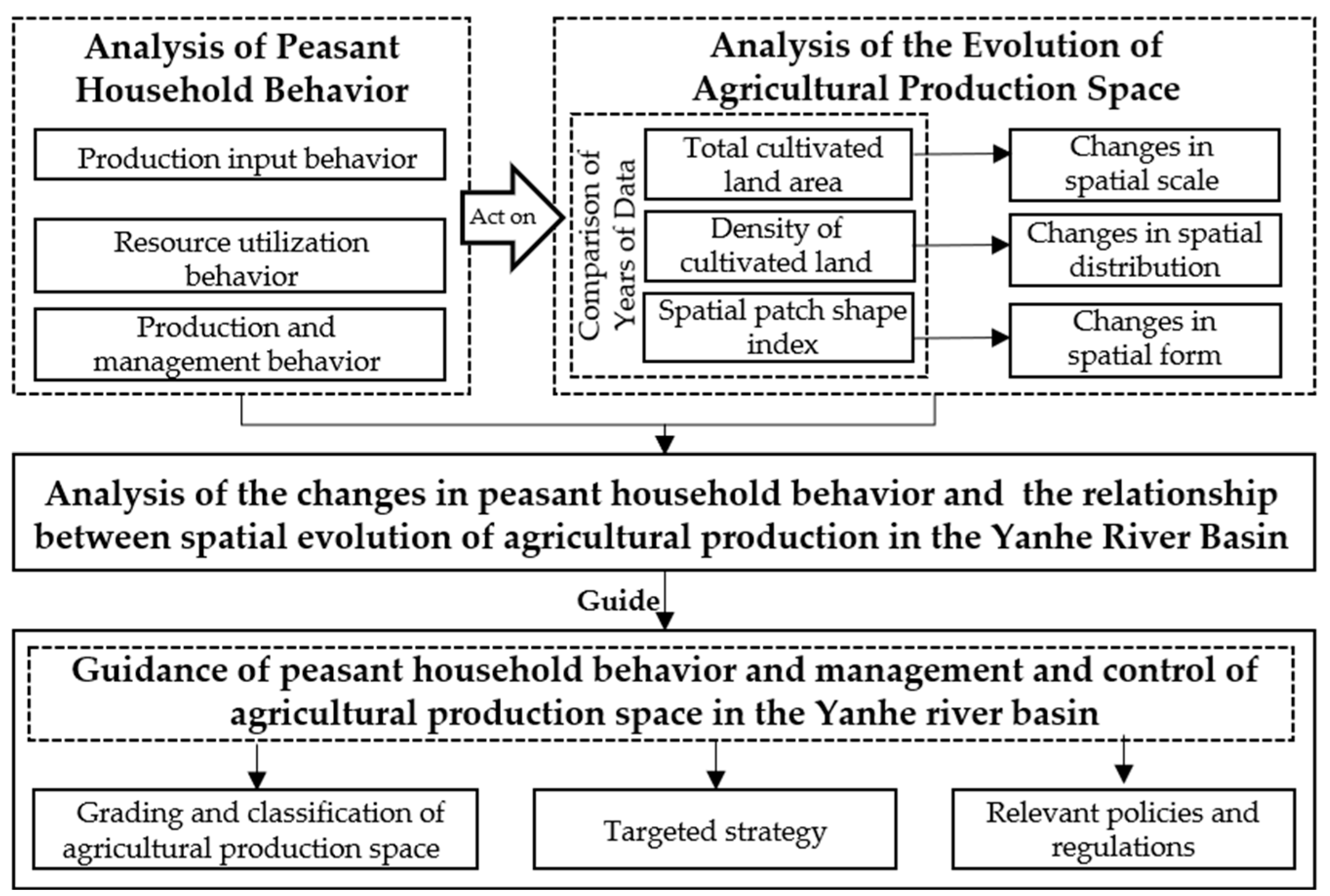
The purpose of our study is to elucidate the evolution process of agricultural production space in the Yanhe River Basin under the influence of peasant household behavior since 1995, to summarize the mutual influence relationship between the two, and to establish a corresponding agricultural production space management and control system based on the figure below (Figure 2).
Specifically, with regard to the research on the evolution of agricultural production space, we selected the total area of cultivated land and its change rate, cultivated land density [24] and the distribution of its center of gravity [25], and cultivated a land patch shape index to express the changes in spatial scale, spatial distribution, and spatial shape, respectively, and then analyzed the interaction relationship between the two in combination with the changes in peasant household behavior. Based on this, we carried out research on agricultural production space management and control according to the behavioral characteristics [26] and cultivation preferences [27] of a peasant household. Firstly, the Shrahler River classification method was used and combined with the classification concept of rural settlements in the loess hilly and gully areas of northern Shaanxi, as proposed by Gan [28], to classify the villages in the Yanhe River Basin. Secondly, the Yanhe River Basin was divided into several subwatersheds based on their different levels of agricultural production advantages as the basic units for evaluating the background and functional suitability of production space [29,30]. In this way, more targeted construction strategies can be proposed for rural areas with different levels of advantages to accurately and scientifically control watershed-scale agricultural production space.

2.3.1. Land Use Dynamic Change Index

The land use dynamic change index is used to reflect the degree of land use quantity change within a certain period, and the calculation formula is as follows:
K = L b   L a L a × 1 N × 100 %
In the formula, K is the dynamic index of cultivated land area change (%), L a is the initial cultivated land area during the research period (km2), L b represents the arable land area at the end of the research period (km2), and N represents the research period (year).

2.3.2. Average Center of Gravity of Geographical Distribution

We used Arcgis 10.4 to measure the average center of gravity of geographical distribution to reflect the spatial distribution center and change pattern of agricultural production in the Yanhe River Basin. Assuming that the coordinates of the center of gravity of the cultivated land in the nth and n + i years are ( X n , Y n ), ( X n + i , Y n + i ), the formula for calculating the distance of the center of gravity movement is as follows:
d = ( X n + i X n ) 2 + ( Y n + i Y n ) 2

2.3.3. Landscape Pattern Index Method

The landscape index [31] refers to a simple quantitative indicator that highly concentrates landscape pattern information and reflects certain aspects of its structural composition and spatial configuration characteristics. We selected 5 indicators and used Fragstats 4.2 for spatial statistics to analyze the morphological changes in agricultural production space in the Yanhe River Basin. These indices cover three aspects of describing patch complexity: area, shape, and diversity [32]. Among them, the area indicator selects the mean patch size (MPS) and the number of patches (NP) to comprehensively measure the degree of fragmentation of cultivated land patches. The shape index selects the perimeter area fractal dimension (PAFRAC) and the mean shape index (MSI) [33] to express the complexity of cultivated land morphology because, under the same patch area, the more complex the shape boundary, the higher the degree of fragmentation. We selected the Shannon diversity index (SHDI) [34] to evaluate patch diversity. The details are shown in Table 1.

2.3.4. Subwatershed Division

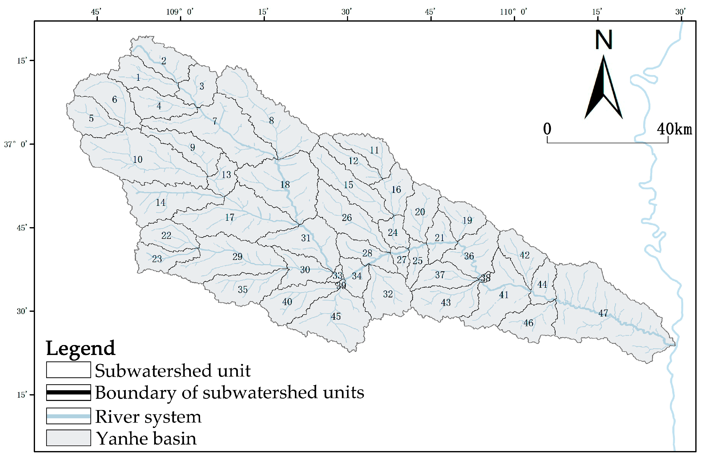
The determination of the subwatershed boundary is based on DEM (the digital elevation model, which is a solid ground model that represents ground elevation in the form of an ordered numerical array) data, combined with the actual investigation and correction, and the SWAT model (soil and water assessment tool, which is a state-of-the-art tool for environmental and water resources management [35]) is applied to complete the determination. The outlet is the Yellow River outlet. The catchment area threshold was set at 2500 ha.

2.3.5. Zoning Evaluation Model

The background suitability evaluation of production is conducted using a multi-factor comprehensive evaluation model [36]. The calculation formula is:
W i = j = 1 n K j × C ij
In the equation, W i is the score of spatial suitability for agricultural production; K j is the weight of the j th indicator; and C ij is the score assigned to the j th indicator of the i th evaluation unit.

2.3.6. Production Function Suitability Evaluation

The functional level of agricultural production is jointly determined by food security and social security functions to reflect the high and stable yield capacity of agricultural production [37]. Among them, agricultural income and farming convenience reflect the social life security function, and the production capacity of food crops represents the food security function. The calculation formula is as follows:
T = ( Y 1 2 + Y 2 2 + Y 3 2 )
T represents the food security function, while   Y 1 , Y 2 , and Y 3 represent the grain yield, fruit yield, and vegetable yield of the watershed, respectively. The evaluation method for the social security function of agricultural production space is the same as that for the food security function.

3. Results

3.1. Characteristics of Peasant Household Behavior Changes and Agricultural Production Space Evolution

3.1.1. Spatial Scale Volatility Decrease: Transformation of Peasant Household Land Management Behavior under Urbanization

Under the influence of urbanization and the policy of returning farmland to forests, some peasant households choose to transfer relatively poor-quality cultivated land in exchange for direct economic benefits, which leads to a sharp decrease in the total amount of cultivated land. According to questionnaire statistics, the proportion of peasant households that engage in agricultural cultivation without arable land has reached 15.21% of the surveyed population, mainly concentrated in river plain areas. Due to road and bridge construction and urban expansion in river valley areas, peasant households display increased land transfer behaviors. Table 2 shows that during the period of 1995–2018, the agricultural production space area in the Yanhe River Basin showed a trend of decreasing volatility, from 3330.07 km2 to 2403.22 km2. With modernized and specialized resource utilization, peasant households have shifted from traditional grain planting to cash crops supplemented by food crops, which can increase land yield per unit area, promote the abandonment of poor-quality cultivated land, and indirectly exacerbate the reduction in cultivated land area [38]. Especially in areas with wide tablelands, peasant households mainly cultivate apples.

3.1.2. Shift in the Gravitational Center of Spatial Distribution: Change in Production Input with Transformations in Development Conditions

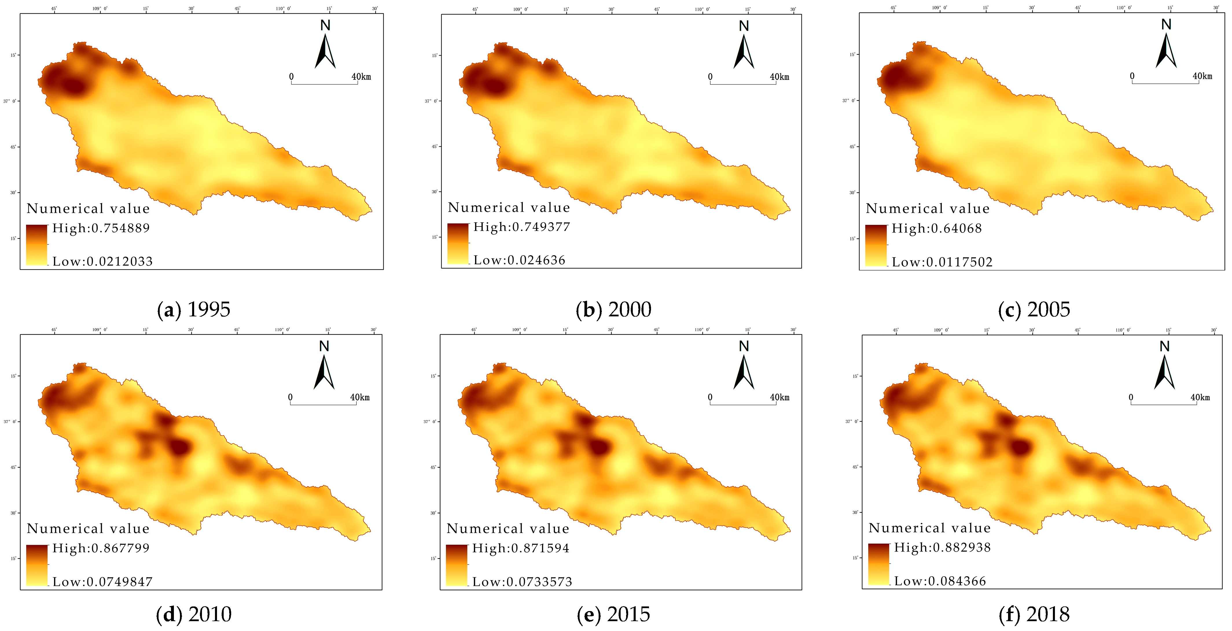
By conducting a cultivated land density analysis on the Arcgis 10.4 platform, we can observe changes in the spatial clustering of agricultural production in the Yanhe River Basin. Figure 3 shows that areas with high cultivated-land density are mainly distributed in valley plains, and the density of cultivated land in the middle and lower reaches of rivers is increasing year by year; however, due to the long-term development of the upper reaches of the Yanhe River Basin, the basis conditions of cultivated land have changed, resulting in a decrease in arable land density. This is because the overall precipitation in the Yanhe River Basin is low, and water resources are relatively scarce. When domestic water demands are difficult to meet, the irrigation level of farmers is generally low, accounting for only 20.2%. Nearly half of the peasant households that choose irrigation are located in river valley areas because it is more convenient to use pumping facilities such as pumps for irrigation.
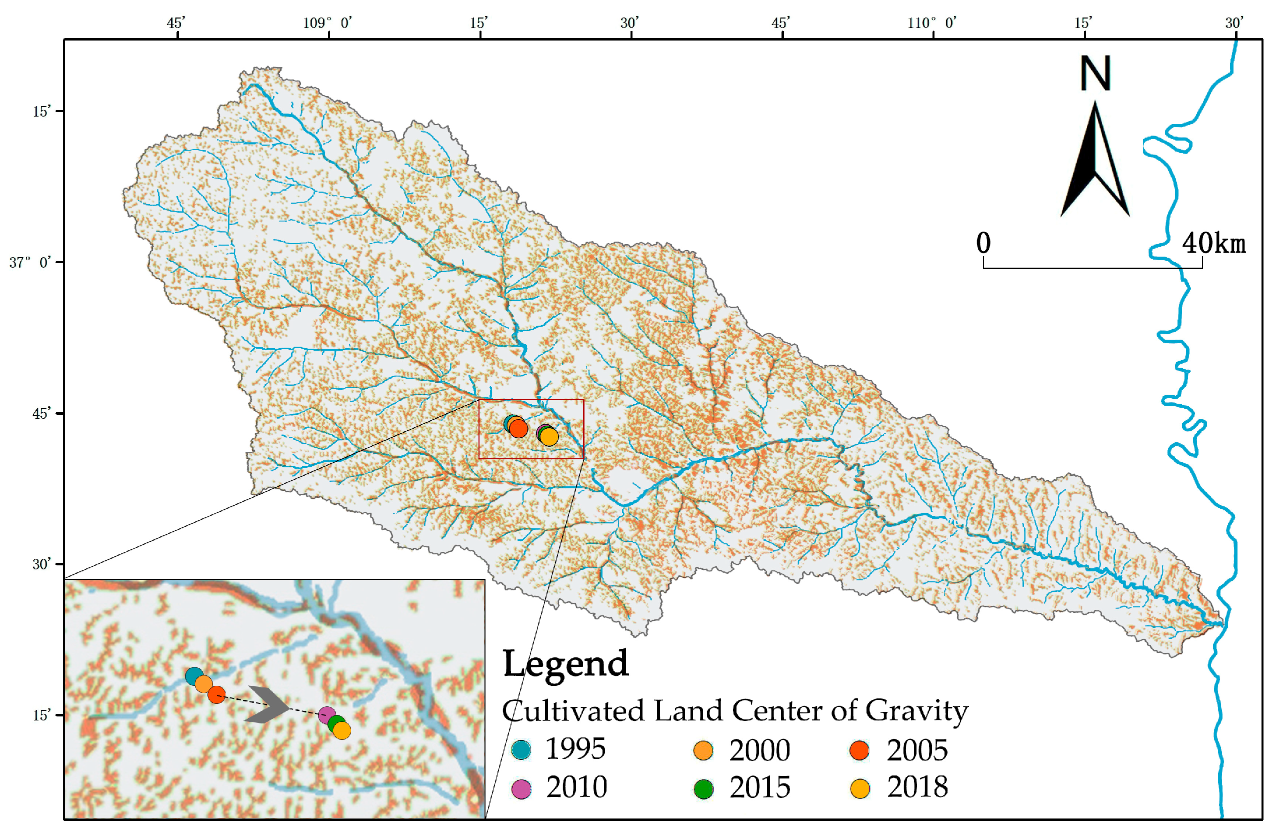
Secondly, the changes in the spatial distribution of agricultural production can be intuitively reflected in the changes in the center of gravity of cultivated land. Figure 4 shows that during 1995–2005 and 2010–2018, the Yanhe River Basin’s cropland center of gravity changed relatively little. During the period from 2005 to 2010, the cultivated land changed dramatically, and the center of gravity moved 4250 m southeastward along the main stream of the river basin. This is because, driven by economic development, the use of agricultural machinery has decreased the Yanhe River Basin’s reliance on the weather. According to a questionnaire survey, the proportion of peasant households using machinery for farming is about 30%, and the higher the level of road construction, the higher the proportion. Due to the high level of urban construction in the middle and lower reaches of rivers, peasant households have a higher input in the production of cultivated land, which promotes the shift of the center of gravity of cultivated land. In addition, the middle and lower reaches of rivers, due to their proximity to cities and the rapid flow of information elements, have also promoted the application of modern farming techniques by peasant households. Therefore, the production input behavior of peasant households is an important driving force for the spatial distribution of agricultural production in the Yanhe River Basin, and their resource utilization behavior changes their production input, indirectly affecting the distribution of agricultural production space.

3.1.3. Spatial Form from Fragmented to Regular: Increase and Decrease in Peasant Household Labor Input under Multiple Factors

As the population increases, the demand for food increases accordingly, leading to a passive enhancement in the land’s security function for peasant households. In this case, a peasant household’s willingness to abandon cultivated land should have been greatly weakened. However, due to the increase in agricultural machinery input, irrigation input, and fertilization input within the Yanhe River Basin, the efficiency of rural agricultural production and operation has increased, and the peasant household’s demand for arable land has decreased, thereby promoting the abandonment of unsuitable arable land. Out of the objective needs of ensuring food security and stable social development, the cultivated land area tends to be stable after reaching a certain critical value. Under the influence of multiple factors, peasant households choose to increase or decrease labor input to obtain the best economic benefits. Table 3 displays the spatial statistics of the agricultural production spatial patch morphology index in the Yanhe River Basin from 1995 to 2018, showing that the number of patches (NP) increased from 5475 to 8771 and then decreased to 8348, and the Shannon index (SHID) increased from 1.41 to 1.66 and then decreased to 1.63. The overall degree of cultivated land fragmentation showed a trend of first increasing and then weakening. The morphological indicators MSI and PAFRAC also indicate that the fragmentation of cultivated land in the Yanhe River Basin increased from 1995 to 2015, and slightly decreased from 2015 to 2018.

3.1.4. Relationship between Peasant Household Behavior Changes and Agricultural Production Space Evolution

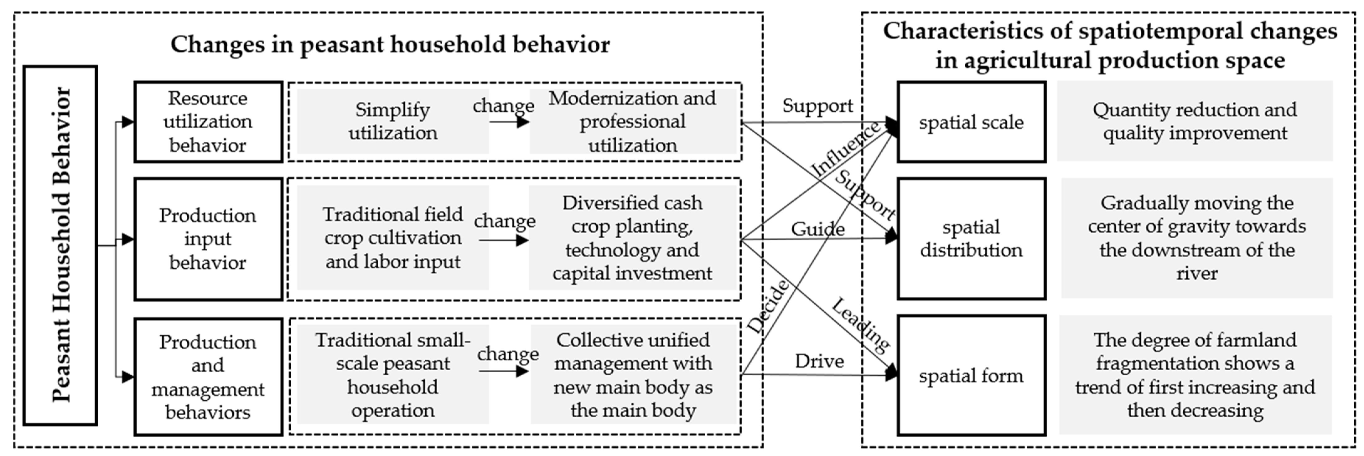
In general, the relationship between peasant household behavior changes and agricultural production space evolution in the Yanhe River Basin has the following three characteristics (Figure 5). (1) Production input behavior and production and management behavior dominate the evolution of agricultural production space. Peasant household behavior has changed from traditional field crop planting, labor input, and small peasant household management to a collective unified management based on diversified economic crop planting, technology, capital input, and new subjects. Together, the Yanhe River Basin’s arable space has been reduced in quantity and improved in quality. In addition, a reduction in the fragmentation of cultivated land is achieved. (2) Resource utilization behavior is an indirect factor affecting the evolution of agricultural production space [39]. With the increase in the likelihood of a peasant household understanding policy, acquiring up-to-date information, and undergoing industrial technology training, resource utilization has shifted from simplification to modernization and specialization, and the choices regarding a peasant household’s production behavior have been further affected [40], which can support adjustments to the spatial quantity and distribution of cultivated land. (3) Under the influence of the different behavioral results of peasant households, the state of the formed agricultural production space is different. In addition, the state of agricultural production space also affects and guides the production behavior of peasant households. Therefore, peasant household behavior decisions are closely related to the soil, location, climate conditions, etc., of agricultural production space, especially considering distances from rivers.

3.2. Characteristics of Peasant Household Behavior Changes and Agricultural Production Space Evolution

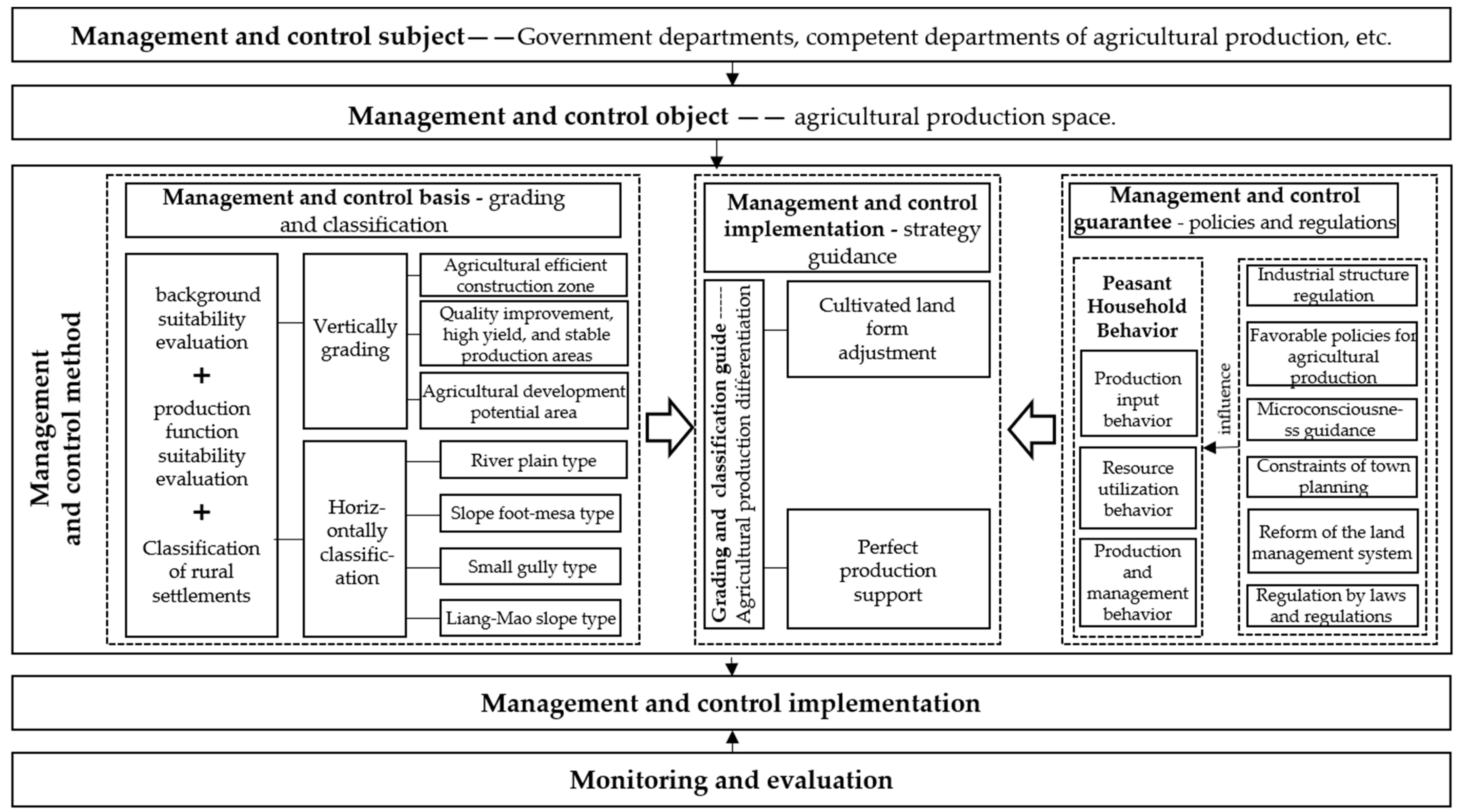
From the analysis of the relationship between the changes in peasant household behavior and the evolution of agricultural production space, it can be seen that external resource information, such as the suitability of cultivated land production, production conditions, use of production tools, and policy information, will have an impact on peasant households’ production choices, which will affect the scale, distribution, and morphological structure of the agricultural production space. Through this, the Yanhe River Basin’s agricultural production is evolving toward large-scale operation, modern utilization, and a diversified industrial structure. Therefore, the construction of the “management and control basis + management and control implementation + management and control guarantee” control method system, which provides orderly guidance regarding peasant households’ spatial behavior to improve agricultural production efficiency, has a positive significance for promoting the high-quality development of agricultural production in the Yanhe River Basin (Figure 6).

3.2.1. Management and Control Basis—Grading and Classification

Zoning management and control refer to dividing the national territory into several different regions according to certain standards, and implementing a control policy of consistency within the region and differences between regions [41], mainly considering natural conditions, such as terrain and hydrogeology. Classification control emphasizes the implementation of different construction strategies according to the basic conditions of the village. The two work together to efficiently guide peasant households’ spatial behavior and promote the management and control of agricultural production space.
  • Zoning of spatial advantages in agricultural production.
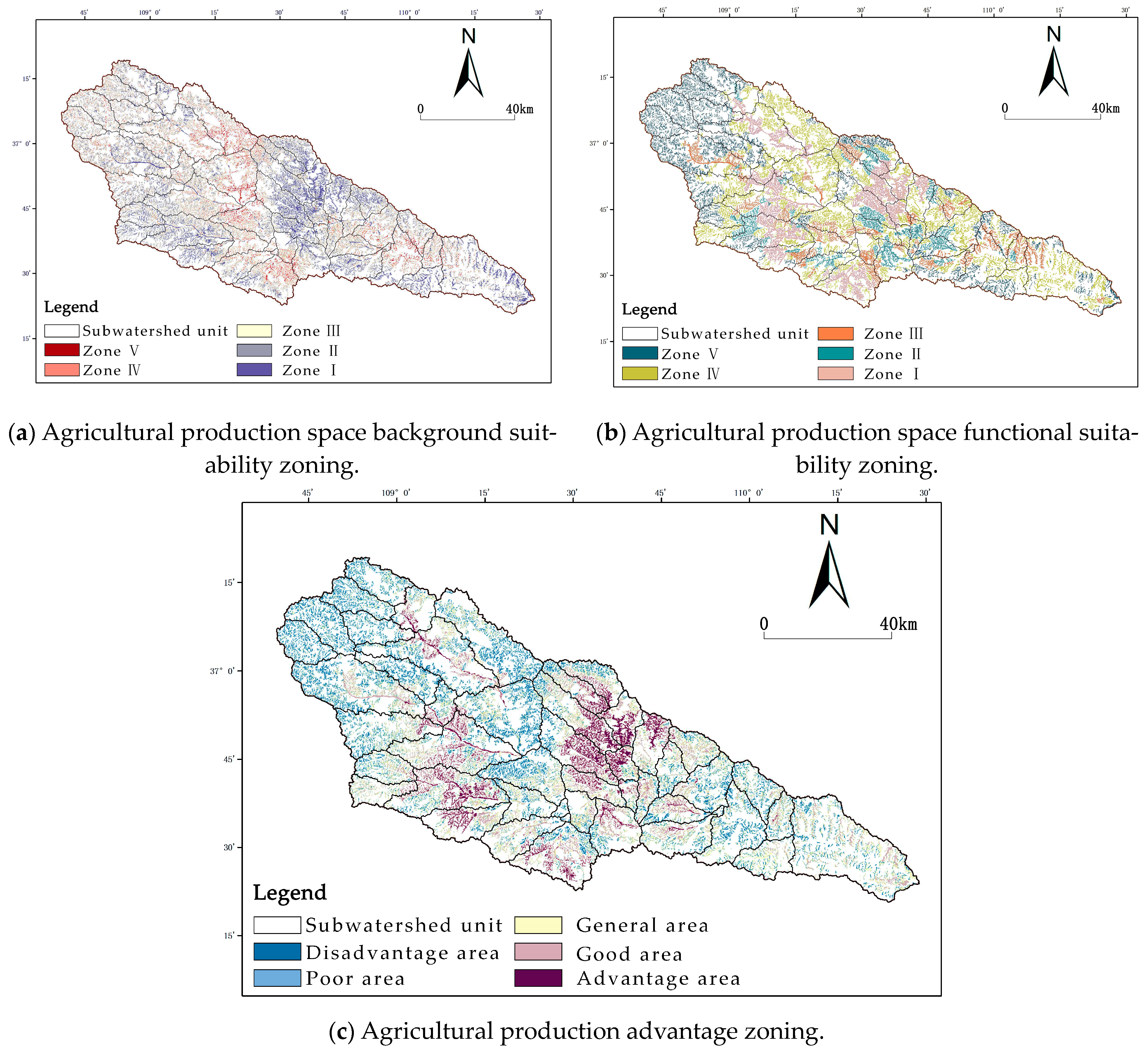
To more accurately and scientifically partition basin-scale agricultural production space, we took subwatersheds as the basic evaluation unit [42] and used Arcgis 10.4 to divide the zoning level advantages that affect agricultural production through the background suitability of production space [29,43] and the functional suitability of production space [30].
Firstly, 47 subwatersheds were generated through the SWAT model operation, as shown in Figure 7.
Secondly, the study uses the multi-factor comprehensive evaluation model to delimit the background suitability zoning of the production space. Based on the Arcgis 10.4 platform, the “Map Algebra tool” in the “Spatial Analysis tool” is used to carry out a weighted superposition analysis on the six evaluation index data (Table 4), namely slope, slope type, geological hazard density, soil type, rainfall, and distance from the river, to obtain the final agricultural production background suitability results (Figure 8a). Additionally, the suitability levels of production space functions were divided from two aspects, namely, food security function and social security function, and five production function levels were obtained (Figure 8b).
Finally, based on the background suitability evaluation and production function suitability evaluation of the production space, the agricultural production space of the entire watershed is divided into an advantage area, a good area, a general area, a poor area, and a disadvantage area through the natural breakpoint method in Arcgis 10.4 (Figure 8c).
2.
Rural classification
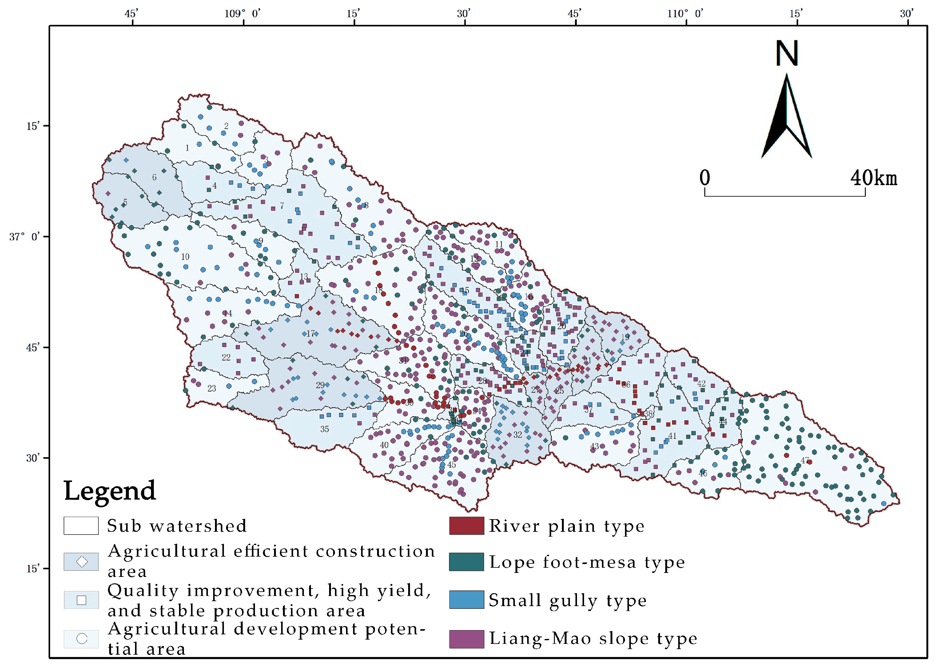
Our analysis of peasant household behavior in the Yanhe River Basin shows that there is a clear correlation between peasant households’ behavioral decisions and their distance from the river. Therefore, rural classification is carried out according to the Shrahler River classification method combined with the concept of rural settlement classification in the loess hilly and gully area of northern Shaanxi [28]. The villages within the 600 m buffer zone of the main stream are classified as river–plain type. Villages within the 500 m buffer zone of primary and secondary rivers are classified as slope foot–mesa type. Villages within the 400 m buffer zone of third and fourth level rivers are classified as small gully types. The remaining villages are classified as the Liang–Mao slope type. Finally, based on DEM data, all administrative villages in the Yanhe River Basin were divided into 457 small-gully-type villages, 211 slope foot–mesa-type villages, 82 river-plain-type villages, and 276 Liang–Mao-slope-type villages in Arcgis 10.4 (Figure 9).
Through the evaluation and statistics of each rural point in the watershed, the agricultural production space of the good and advantageous area located in the production space is positioned as an efficient agricultural construction area. The general area within the agricultural production space is positioned as an area with high quality, high yield, and stable production. The poor and disadvantageous area located in the agricultural production space are positioned as the agricultural development potential area. Zoning of spatial advantages in agricultural production and rural classification forms the grading and classification management and control foundation of agricultural production space in the Yanhe River Basin, as shown in Figure 10.

3.2.2. Management and Control Implementation—Strategy Guidance

According to the results of village grading and classification, each village is guided to develop targeted agricultural industries, and corresponding control strategies are proposed (Table 5).

Adjust Cultivated Land Form

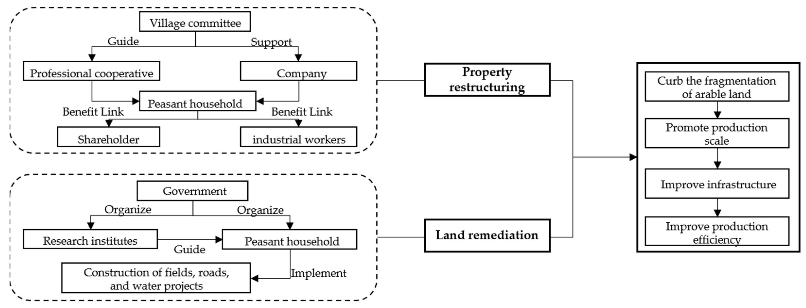
Due to the characteristics of the Yanhe River Basin’s natural topography and the reality of China’s long-time small-scale peasant economy, there is a serious rural farmland fragmentation problem in the entire basin. To adjust the spatial structure of different types of cultivated land in the watershed, it is necessary to identify the causes of its fragmentation. Fragmentation may be caused by land titles or topography. Targeted land parcel adjustment is conducive to realizing the large-scale operation of agricultural production space, including property reorganization and land consolidation (Figure 11).
For the fragmentation of agricultural production space caused by property rights factors, it is necessary to rely on the “three changes” regarding agricultural reform policy and government guidance while adapting to the needs of large-scale agricultural production, ensuring that the cultivated land area does not decrease, and highlighting the main role played by peasant households. Through land replacement and land merging, land contracting rights have been transferred to new business entities, such as large planters and professional cooperatives. By realizing the transfer of land ownership, scattered plots are merged into larger plots (Table 6).
For the fragmentation of agricultural production space caused by terrain factors, the government can take the lead and rely on the production–university–research bases of scientific research institutes to provide technical guidance to peasant households, organizing them to carry out land consolidation.
  • The type of cultivated land that is distributed along the strips mainly creates efficient industrial space through land replacement, large-scale operation, and undertaking water sources.
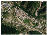
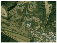
  • The form of circular cultivated land in which cultivated land is concentrated around residential areas is more suitable for merging plots according to the terrain, shortening the distance between peasant household plots, facilitating farming and the management of peasant households, and promoting intensive management.
  • For more complex cultivated land forms, the adjustment of land plots is carried out according to the cultivated land’s topographical conditions. Linear staggered roads and arable land are more convenient for mechanized management and peasant household cultivation.

Improve Production Support

For the layout of rural agricultural production space, the configuration of agricultural infrastructure plays a strong supporting role, including agricultural information services, technological services, mechanical services, farmland water conservancy, road networks, etc. Our study utilizes government support for modern agricultural projects and combines the development needs of agricultural business entities to reasonably layout agricultural infrastructure (Table 7), accelerating the construction of agricultural modernization and standardization.

3.2.3. Management and Control Guarantee—Policies and Regulations

The spatial policy adjusted and formulated based on the overall national development strategy and local spatial control planning will directly restrict the disorder and destructiveness of peasant households’ spatial movement [44]. This is of decisive significance for promoting the implementation of agricultural production space control, which is also considered the main method to ensure the implementation of control. The purpose of the reform and implementation of various policies and systems is to mobilize peasant households’ enthusiasm for production and promote positive improvements in agricultural production. The regulation of industrial structures can prevent disorderly development under the independent choices of peasant households. Regulation can promote the transformation of the main body of peasant households and realize large-scale agricultural production. In addition, the guidance of concept awareness can increase peasant households’ understanding of policy information and modern technology, guiding their production choices, which can have a positive impact on agricultural production space.

4. Discussion

Agricultural production space is the basic spatial carrier for ensuring national food security and achieving sustainable rural development. The management and control of agricultural production space by zoning and classification conforms to the basic approach of agricultural production space planning and research in local territorial space planning [42]. In the middle- and high-speed urbanization stages with an intensified flow of people, information, and other factors, we should strengthen the research on the role of external humanistic and social factors, such as agricultural subjects, policies, and systems on agricultural production space [45]. Therefore, in this paper, we innovatively consider the management and control of agricultural production space from the perspective of the “man–land relationship”, improve upon previous research that only selects a single peasant household behavior for analysis [16,19,20], and conduct a comprehensive analysis of the evolution of the agricultural production space driven by various peasant households’ behavioral decisions in the Yanhe River Basin. The village types are divided according to the distance between the village and the river, and the agricultural production advantage level is divided according to the background suitability evaluation and functional level evaluation of the agricultural production space. The grading and classification management and control framework is formed, which aims to ensure the efficient development of agricultural production space in the watershed. Control strategies to guide peasant household behavior and optimize the layout of agricultural production space are proposed. Compared with the previous management and control system [46], it has more targeted implementation strategies and land consolidation methods. Different from the conventional management and control framework that takes the administrative unit as the basic unit [47], we take the subwatershed as the basic unit and combine it with rural classification to highlight the characteristics of watershed management and control. At the level of theoretical significance, we integrate human behavior and consider the complexity of the countryside system, highlight the humanistic significance of rural spatial problems, enrich the research content of peasant household behavior theory in the Yanhe River Basin, and provide new ideas for the management and control of agricultural production space in the Yellow River Basin and other regions of China. In terms of practical significance, our research can provide a reference for local governments to formulate agricultural production-related policies. According to our zoning classification results, all kinds of villages can set planning goals and development paths according to their own characteristics. Therefore, this paper has guiding significance for promoting agricultural production and a sustainable development of rural areas in Yanhe River Basin.
However, there are also some areas for further exploration in our research. While we consider the impact of the three types of behaviors, namely farmers’ production and operation, production inputs, and resource utilization on agricultural production space, we have not specifically studied the degree to which a farmer’s decision affects agricultural production space. Secondly, our article only summarizes the spatial evolution characteristics of agricultural production under the influence of farmers’ behavior, and does not delve into its internal principles. A further exploration of its operating mechanism should be conducted.
Subsequent research can consider quantifying the interaction between peasant household decision-making and agricultural production space, exploring the operation mechanism of agricultural production space under the influence of peasant household behavior, and refining the grading and classification of the management and control of agricultural production space in watersheds. This will specifically solve the agricultural production space problems that characterize the Yanhe River Basin and rural areas in loess, hilly, and gully areas, as well as improve the function and production efficiency of production space. By doing so, we can provide a theoretical reference and technical support for the control of rural production space in the loess plateau region, achieving broader and deeper rural sustainable development.

5. Conclusions

Based on the theory of mutual influence between peasant household behavior and agricultural production space, we proposed a management and control method system for agricultural production space from the perspective of peasant household behavior that can guide the efficient development of agricultural production space in the Yanhe River Basin. Our main conclusions are as follows:
  • Due to the transformation of peasant household land management behavior under urbanization, the change in production input brought about by changes in development conditions, and the increase or decrease in peasant household labor input under multiple factors, the agricultural production space in the Yanhe River Basin presents three major evolutionary characteristics: a reduced fluctuation in spatial scale, a downstream shift in the center of gravity of spatial distribution, and a transformation of the spatial form from fragmented to regular.
  • Production input behavior and production and management behavior will have a direct impact on the selection of crop species planted in agricultural space, the direction of production development, and the layout of production space. Therefore, the peasant household’s production and management behavior and production input behavior are the dominant drivers of the Yanhe River Basin’s agricultural production space evolution. Resource utilization behavior is the impact on the production space after peasant households use external assistance to improve their own agricultural production behavior, which is the external driving factor.
  • Based on the impact of peasant household behavior on agricultural production space evolution, our study regulates peasant household behavior decision-making and guides the optimization of the agricultural production structure according to the grading and classification of the “management and control basis + management and control implementation + management and control guarantee” control method system. From the two aspects of improving production infrastructure support and adjusting the form of cultivated land, the implementation of control measures has been promoted. From the two levels of macro-policy constraints and micro-awareness guidance, the effective implementation of management and control is guaranteed.

Author Contributions

Conceptualization, Q.H., L.Z. and Y.D.; data curation, S.C. (Shihan Chen), Y.M., S.C. (Su Chen) and X.F.; formal analysis, S.C. (Shihan Chen), S.C. (Su Chen), Y.M. and X.F.; funding acquisition, Q.H., Y.D. and Y.Z.; investigation, X.F.; methodology, S.C. (Shihan Chen), Q.H., Y.Z. and X.F.; project administration, Y.D.; resources, Q.H. and X.F.; software, Y.Z. and L.Z.; supervision, Q.H. and Y.D.; validation, Q.H. and Y.D.; visualization, S.C. (Shihan Chen) and S.C. (Su Chen); writing—original draft, S.C. (Shihan Chen). All authors have read and agreed to the published version of the manuscript.

Funding

This research was funded by the National Natural Science Foundation of China, grant number 52178030, the National Key Research and Development Program under Grant 2022YFC3802803, the Philosophy and Social Science Research Project in Shaanxi, grant number 2023ZD0622 and 2022HZ1870, the Science and technology Project of Gansu Architectural Design Institute, grant number HZ2021-GH01, and the Fundamental Research Funds for the Central Universities, CHD, grant number 300102412723.

Institutional Review Board Statement

Not applicable.

Informed Consent Statement

Not applicable.

Data Availability Statement

Not applicable.

Acknowledgments

We are thankful to the anonymous reviewers for their valuable comments.

Conflicts of Interest

The authors declare that they have no known competing financial interests or personal relationships that could have appeared to influence the work reported in this paper.

References

  1. Liu, Y. Research on the urban-rural integration and rural revitalization in the new era in China. Acta Geogr. Sin. 2018, 73, 637–650. [Google Scholar]
  2. Qian, F.K.; Chi, Y.R.; Lal, R. Spatiotemporal characteristics analysis of multifunctional cultivated land: A case-study in Shenyang, Northeast China. Land Degrad. Dev. 2020, 31, 1812–1822. [Google Scholar] [CrossRef]
  3. Wang, C.; Li, H. Conceptual and research frameworks of rural production space system. Prog. Geogr. 2017, 36, 913–923. [Google Scholar]
  4. Teshome, D.S.; Moisa, M.B.; Gemeda, D.O.; You, S.C. Effect of Land Use-Land Cover Change on Soil Erosion and Sediment Yield in Muger Sub-Basin, Upper Blue Nile Basin, Ethiopia. Land 2022, 11, 2173. [Google Scholar] [CrossRef]
  5. Arunrat, N.; Sereenonchai, S.; Kongsurakan, P.; Hatano, R. Soil organic carbon and soil erodibility response to various land-use changes in northern Thailand. Catena 2022, 219, 106595. [Google Scholar] [CrossRef]
  6. Arunrat, N.; Sereenonchai, S.; Kongsurakan, P.; Iwai, C.B.; Yuttitham, M.; Hatano, R. Post-fire recovery of soil organic carbon, soil total nitrogen, soil nutrients, and soil erodibility in rotational shifting cultivation in Northern Thailand. Front. Environ. Sci. 2023, 11, 1117427. [Google Scholar] [CrossRef]
  7. Lv, J.; Yang, B.D.; Yang, Y.J.; Zhang, Z.H.; Chen, F.; Liu, G.J. Spatial Patterns of China’s Major Cities and Their Evolution Mechanisms during the Past Decades of Reform and Opening Up. Procedia Eng. 2017, 198, 915–925. [Google Scholar] [CrossRef]
  8. Hui, A. Research on the Management Pattern of Small Watershed Treatment in Loess Plateau Region. Adv. Mater. Res. 2013, 664, 117–122. [Google Scholar]
  9. Wen, X.Y.; Liu, T.T.; Tao, S.J. Discussion on the management and control strategy of production-living ecological space based on humanistic needs: Take Honghe Prefecture of Yunnan Province as an example. Shanghai L. Resour. 2022, 43, 49–54, 85. [Google Scholar]
  10. Liu, Y.S.; Wang, Z.Y.; Qu, Y. Construction of Ecological Spatial Control System Based on Ecosystem Services Measurement. Chin. Landsc. Archit. 2019, 35, 77–82. [Google Scholar]
  11. Zhai, D.Q. From Space Conflict to Space Integration: Territorial Space Management Optimization and Planning Response from the Perspective of Man-Land Coupling. City Plan. Rev. 2022, 46, 7–17. [Google Scholar]
  12. Geng, H.Z.; Li, K.M. The Regulation of Whole Rural Space under the Territory Development Planning System Analysis Based on Shanghai’s Experience. Urban Plan. Forum 2020, 4, 58–66. [Google Scholar]
  13. Guo, X.L.; Qu, X.Q.; Sun, L. Study on ecological spatial pattern of Qingdao from the perspective of territorial spatial planning. J. Qingdao Technol. Univ. 2022, 43, 79–87. [Google Scholar]
  14. Fang, F.; He, R.W. A study on the characteristics and mechanisms of the spatial evolution of rural three lives from the perspective of farmer behavior. Learn. Pract. 2018, 1, 101–110. [Google Scholar]
  15. Jiang, G.; He, X.; Ma, W.; Wang, M.; Zhang, R. Rural settlements spatial pattern evolution and zoning district based on spatial autocorrelation. Trans. Chin. Soc. Agric. Eng. 2015, 31, 265–273. [Google Scholar]
  16. Chen, Q.; Yang, J. The Analysis of Peasant Households’ Farmland Utilization Behavior and Influencing Factors of Fujian Forest Region under the Perspective of Carbon Emissions. Ecol. Econ. 2018, 34, 33–37. [Google Scholar]
  17. Xie, H.L.; Wang, P.; Yao, G.R. Exploring the Dynamic Mechanisms of Farmland Abandonment Based on a Spatially Explicit Economic Model for Environmental Sustainability: A Case Study in Jiangxi Province, China. Sustainability 2014, 6, 1260–1282. [Google Scholar] [CrossRef]
  18. Zhang, X.B.; de Vries, W.T.; Li, G.; Ye, Y.M.; Zheng, H.Y.; Wang, M.R. A behavioral analysis of farmers during land reallocation processes of land consolidation in China: Insights from Guangxi and Shandong provinces. Land Use Policy 2019, 89, 104230. [Google Scholar] [CrossRef]
  19. Fu, J.J.; Wu, L. The behavior of peasant household land mobility factors affecting the empirical analysis based on the Heilongjiang Province ningan investigation. Contemp. Rural Financ. Econ. 2019, 1, 2–8. [Google Scholar]
  20. Zhao, J.J.; Liu, L.Z.; Qi, J.L.; Dong, J.P. Study on the influence of environmental regulation on the environmentally friendly behavior of farmers in China. Front. Environ. Sci 2022, 10, 1009151. [Google Scholar] [CrossRef]
  21. Wang, Y.; Liu, J.; Xue, H.; Tan, Z. Rural Plan Implementation Based on Land Property Rights Innovation: A Case Study of Qinggangshu Village in Chengdu. China City Plan. Rev. 2018, 27, 34–41. [Google Scholar]
  22. Chen, Y.S.; Chen, B.M.; Luo, R.J.; Yao, S.H.; Yao, D.Q. An Analysis on the Peasant Household’s Behavior in the Utilizing Process of Natural Resources in Plowland-scarcity Regions—Taking Shexian County, Anhui Province as the Example. Acta Agric. Univ. Jiangxiensis (Nat. Sci. Edn.) 2005, 6, 943–948. [Google Scholar]
  23. Mu, X.M.; Wang, S.Y.; Gao, P.; Wang, W. Temporal Change Analysis of Hydrological Factors in the Yanhe River Basin. Bull. Soil Water Conserv. 2005, 1, 11–14. [Google Scholar]
  24. Zhang, H.T.; Guo, L.; Chen, J.Y.; Fu, P.H.; Gu, J.L.; Liao, G.Y. Modeling of Spatial Distributions of Farmland Density and Its Temporal Change Using Geographically Weighted Regression Model. Chin. Geogr. Sci. 2014, 24, 191–204. [Google Scholar] [CrossRef]
  25. Chen, L.; Wang, Q. Study on the Contradiction between Population and Cultivated Land and the Priority Protection of Cultivated Land in the Policy of Poverty Alleviation: A Case Study of the Upper Reaches of Min River, Sichuan Province, China. Sustainability 2021, 13, 3348. [Google Scholar] [CrossRef]
  26. Su, D.S.; Ling, Z.; Long, X.T. Awareness of farmer organizations cultivation and rural NGOs development. Econ. Res. Guid. 2010, 34, 52–55. [Google Scholar]
  27. Guo, G.C.; Wen, Q.Y.; Zhu, J.J. The Impact of Aging Agricultural Labor Population on Farmland Output: From the Perspective of Farmer Preferences. Math. Probl. Eng. 2015, 2015, 7830618. [Google Scholar] [CrossRef]
  28. Gan, Z.M.; Yue, D.P.; Gan, R. Distribution and land use characteristics of rural settlements in loess hilly and gully areas of northern Shaanxi. J. Shaanxi Norm. Univ. 2004, 3, 102–106. [Google Scholar]
  29. Wan, Q.; Wang, C.; Du, X. Redefinition of patterns of production space on village scale based on evaluation of the land scale operation conditions for Dazhu Village, Chongqing. Resour. Sci. 2016, 38, 387–394. [Google Scholar]
  30. He, Y.Z.; Wang, C. The evolution and sustainable development capacity of rural production space system based on information entropy. J. Nat. Resour. 2019, 34, 815–828. [Google Scholar] [CrossRef]
  31. Wu, L.; Luo, J.; Li, M. Evaluation method of land-scaled consolidation potential based on landscape pattern principle. Trans. Chin. Soc. Agric. Eng. 2010, 26, 300–306. [Google Scholar]
  32. Jia, Y.Q.; Tang, L.N.; Xu, M.; Yang, X.Y. Landscape pattern indices for evaluating urban spatial morphology—A case study of Chinese cities. Ecol. Indic. 2019, 99, 27–37. [Google Scholar] [CrossRef]
  33. He, S.W.; Yu, S.; Li, G.D.; Zhang, J.F. Exploring the influence of urban form on land-use efficiency from a spatiotemporal heterogeneity perspective: Evidence from 336 Chinese cities. Land Use Policy 2020, 95, 104576. [Google Scholar] [CrossRef]
  34. Beisel, J.-N.; Moreteau, J.-C. A simple formula for calculating the lower limit of Shannon’s diversity index. Ecol. Modell. 1997, 99, 289–292. [Google Scholar] [CrossRef]
  35. Bui, M.T.; Lu, J.; Nie, L. Evaluating the effects of watershed subdivision on hydrological simulation by Swat model in an arctic watershed. Earth Environ. Sci. 2020, 581, 012026. [Google Scholar] [CrossRef]
  36. Chen, M.X.; Lu, D.D.; Zhang, H. Comprehensive Evaluation and the Driving Factors of China’s Urbanization. Acta Geogr. Sin. 2009, 64, 387–398. [Google Scholar]
  37. He, Y.Z.; Wang, C. Evaluation and Pattern Optimization of Rural Production Space System Function: A Case Study of Banan District, Chongqing Municipality. Econ. Geogr. 2019, 39, 162–171. [Google Scholar]
  38. Everest, B. Farmers’ adaptation to climate-smart agriculture (CSA) in NW Turkey. Environ. Dev. Sustain. 2021, 23, 4215–4235. [Google Scholar] [CrossRef]
  39. Guo, H.P.; Xu, S.; Wang, X.T.; Shu, W.; Chen, J.; Pan, C.L.; Guo, C. Driving Mechanism of Farmers’ Utilization Behaviors of Straw Resources—An Empirical Study in Jilin Province, the Main Grain Producing Region in the Northeast Part of China. Sustainability 2021, 13, 2506. [Google Scholar] [CrossRef]
  40. Everest, B. Farmers’ adaptations of soil and water conservation in mitigating climate change. Arab. J. Geosci. 2021, 14, 142141. [Google Scholar] [CrossRef]
  41. Fang, Y. Research on the use of requlation rules for zoning and classification of territorial space. Shanghai L. Resour. 2023, 44, 10–14. [Google Scholar]
  42. Zhao, Y.J.; Liang, R.M.; Ding, A.Z.; Lan, W.L. Differences in the influence of landscape features on river water quality at different spatial scales. Acta Ecol. Sin. 2023, 43, 1–11. [Google Scholar]
  43. Getahun, Y.S.; Gebremedhn, A.Y.; Lemma, E.; Tesfay, F.; Tadesse, S.A. Surface irrigation potential assessment of Chacha River Watershed, Jemma subbasin of upper Blue Nile, Ethiopia. Front. Environ. Sci. 2023, 11, 1129716. [Google Scholar] [CrossRef]
  44. Li, H.B.; Yuan, Y.; Zhang, X.L.; Li, Z.; Wang, Y.H.; Hu, X.L. Evolution and transformation mechanism of the spatial structure of rural settlements from the perspective of long-term economic and social change: A case study of the Sunan region, China. J. Rural Stud. 2019, 93, 234–243. [Google Scholar] [CrossRef]
  45. Pan, Y.X.; Yang, R.; Lin, Y.C. Evolution of spatial resource and environment carrying capacity and suitability of agricultural production in China and its coupling mechanism. China Land Sci. 2023, 37, 20–31. [Google Scholar]
  46. Li, S.N.; Zhao, X.Q.; Pu, J.W.; Miao, P.P.; Wang, Q.; Tan, K. Optimize and control territorial spatial functional areas to improve the ecological stability and total environment in karst areas of Southwest China. Land Use Policy 2021, 100, 104940. [Google Scholar] [CrossRef]
  47. Ge, D.Z.; Lu, Y.Q. A strategy of the rural governance for territorial spatial planning in China. J. Geogr. Sci. 2021, 31, 1349–1364. [Google Scholar] [CrossRef]
Figure 1. Location map of Yanhe River Basin area.
Sustainability 15 08399 g001
Figure 2. Research path.
Sustainability 15 08399 g002
Figure 3. Comparison of cultivated land density in the Yanhe River Basin from 1995 to 2018.
Sustainability 15 08399 g003
Figure 4. Changes in the spatial center of gravity of rural agricultural production in the Yanhe River Basin.
Sustainability 15 08399 g004
Figure 5. Relationship between peasant household behavior changes and agricultural production space evolution.
Sustainability 15 08399 g005
Figure 6. Framework diagram of agricultural production space management and control system in the Yanhe River Basin.
Sustainability 15 08399 g006
Figure 7. Subwatershed unit map of the Yanhe River Basin.
Sustainability 15 08399 g007
Figure 8. Agricultural production space advantage zoning map of the Yanhe River Basin.
Sustainability 15 08399 g008
Figure 9. Rural classification map of the Yanhe River Basin.
Sustainability 15 08399 g009
Figure 10. Agricultural production space management and control grading and classification diagram of the Yanhe River Basin.
Sustainability 15 08399 g010
Figure 11. Pattern diagram of rural agricultural production space morphological reorganization under the guidance of peasant household behavior.
Sustainability 15 08399 g011
Table 1. List of patch feature evaluation formulas and their meanings.
Index TypePatch IndicatorsFormulaFormula ExplanationIndicator Significance
AreaNumber of Patches (NP)NP = NN is the number of patchesThe higher the value, the higher the degree of fragmentation of cultivated land
Mean Patch Size (MPS) MPS = A N A is the total area of patches;
N is the number of patches
The most direct indicator reflecting patch size. The higher the value, the lower the degree of fragmentation
ShapeMean Shape Index (MSI) MSI = j = 1 n [ 2 P ij 2 π × a ij ] n P ij represents the circumference of the j th patch of the ith patch type, and   a ij is the area of the jth patch of the ith patch type; n is the number of patchesThe larger the value, the higher the complexity of the plaque
Perimeter Area Fractal Dimension (PAFRAC) PAFRAC = 2 ln ( P / 4 ) / lnA P represents the perimeter of the patch; A represents the area of the patchThe larger the value, the more complex the shape of the patch
DiversityShannon Diversity Index (SHDI) SHDI = i = 1 m ( P i lnP i ) P i represents the proportion occupied by landscape patch type i It reflects spatial heterogeneity: the larger the index, the higher the fragmentation degree
Table 2. Changes in cultivated land quantity.
YearCultivated Land Area (km2)Cultivated Land Change Area (km2)Annual Change Rate of Cultivated Land Area (%)
19953330.07
20003310.81−19.26−0.58
20053094.37−216.44−6.54
20102442.39−651.99−21.07
20152428.12−14.27−0.58
20182403.22−24.90−1.03
Table 3. Statistical table of patch form index for rural agricultural production space in the Yanhe River Basin from 1995 to 2018.
YearNumber of Patches (NP)Mean Patch Size (MPS)Mean Shape Index (MSI)Perimeter Area Fractal Dimension (PAFRAC)Shannon Diversity Index (SHDI)
19955375143.022.431.551.41
20005454140.942.451.551.43
20055489140.052.531.581.54
2010854090.012.411.591.63
2015877187.642.401.571.66
2018834892.082.411.581.63
Table 4. Index table of agricultural production space background suitability partition.
Target LayerProduction Space PartitionWeight
Favorable RegionMore Suitable RegionGeneral RegionLess Suitable RegionUnsuitable Area
Slope0–22–66–1515–25>250.30
Slope type−0.2–0.2−0.5–−0.2;
0.2–0.5
−0.5–−1;
0.5–1
−1–−2;
1–2
<−2; >20.21
Disaster densityDistance from river0.21
Soil typeYellow loamy soilDack loessial soil, red clayRhogosolAlluvial soilLake0.12
RainfallDistance from river0.10
Distance from river0–500 m500–1000 m1000–1500 m1500–2000 m>2000 m0.06
Assignment1.00
Table 5. Guide table of agricultural production space partition management in the Yanhe River Basin.
PartitionControl StrategyRural TypeDevelopment Guidance
Agriculturally efficient construction area
Control the scale and quantity of cultivated land
Strengthen industrial clusters, scale management, agricultural infrastructure construction, and agricultural modernization
Expand agricultural function, improve the industrial chain, and increase agricultural added value
Introduce agriculture-related enterprises, build agricultural demonstration parks, establish negative lists for agricultural protection, and regulate enterprise development
River plain typeModern urban agriculture development driven by cities and towns
Slope foot–mesa typeDevelop leisure agriculture and modern agriculture
Small gully typeDevelop tourism agriculture and efficient agriculture
Liang–Mao slope typeDevelop modern science and technology agriculture
Quality improvement, high yield, and stable production area
Control the scale and quantity of cultivated land
Strengthen farmland protection and improve agricultural infrastructure
Realize large-scale operation through land consolidation or property right adjustment of peasant households
Guide peasant households to make reasonable adjustments to agricultural planting structure
Strengthen peasant households’ high-quality construction of cultivated land and improve production efficiency
Promote agricultural specialization through an agricultural information platform
River plain typeStrengthen regional ties and develop modern agriculture
Slope foot–mesa typeStrengthen urban–rural ties and develop specialized agriculture
Small gully typeSpecialized organization and develop special agriculture
Liang–Mao slope typeJoint construction; develop modern agriculture
Agricultural development potential area
Strengthen ecological conservation and supervision, prohibit farmland abandonment, and encourage sporadic non-agricultural land to become cultivated land
Encourage high-standard farmland construction and land improvement
Improve food production efficiency through the comprehensive layout of agricultural infrastructure
River plain typeSupport and develop urban agriculture
Slope foot–mesa typeSupport and develop ecological agriculture and special agriculture
Small gully typeDevelop ecological agriculture and special agriculture
Liang–Mao slope typeDevelop ecology and cultivate modern agriculture
Table 6. Diagram of structural adjustment of different types of cultivated land space.
Morphological TypeMany Striped and Blocky SpacesMany Blocky and Annular SpacesMixture of Striped, Blocky, and Annular Spaces
ExamplesSustainability 15 08399 i001Sustainability 15 08399 i002Sustainability 15 08399 i003
Morphological adjustment modeSustainability 15 08399 i004Sustainability 15 08399 i005Sustainability 15 08399 i006
Table 7. Table of guidelines for agricultural infrastructure configuration in the Yanhe River Basin.
Category of Agricultural InfrastructureAgricultural InfrastructureConfiguration Guidelines
Agricultural leisure serviceAgricultural demonstration parkSet up according to the characteristic agricultural industry, with a certain scale, accurate functional positioning, attention to supervision, and standardized development
Farm experience park, picking parkSet up according to market size
Farmland water conservancy projectRainwater collection pointConform to the basin water conservancy planning and water resource carrying capacity, with an irrigation design guarantee rate of 50–75%
Irrigation canal
Agricultural science and technology serviceAgricultural technology training stationSet up in conjunction with important facility points of district and county governments, town governments, and agricultural units
Agricultural research baseSet up according to technical conditions
Agricultural information serviceAgricultural information stationThe location of district and county governments, town governments, and important facility points in agricultural units can be configured, and villages can be set according to their needs
Agricultural machinery serviceFarm machinery repair stationThe location of district and county governments, town governments, and important facility points in agricultural units can be configured
Agricultural materials serviceAgricultural supply sales stationSet up according to market demand
Agricultural logistics serviceAgricultural product logistics centerSet up according to market size
Agricultural product storage centerSet up according to market size, combined with the setting of agricultural product storage centers
Disclaimer/Publisher’s Note: The statements, opinions and data contained in all publications are solely those of the individual author(s) and contributor(s) and not of MDPI and/or the editor(s). MDPI and/or the editor(s) disclaim responsibility for any injury to people or property resulting from any ideas, methods, instructions or products referred to in the content.