Article

Sustainable Road Planning for Trucks in Urbanized Areas of Chinese Cities Using Deep Learning Approaches

1
School of Economics and Management, China University of Petroleum (East China), Qingdao 266580, China
2
School of Management Engineering, Qingdao University of Technology, Qingdao 266520, China
3
School of Economics and Management, Zhejiang University of Science and Technology, Hangzhou 310023, China
*
Author to whom correspondence should be addressed.
Sustainability 2023, 15(11), 8763; https://doi.org/10.3390/su15118763
Submission received: 19 March 2023 / Revised: 28 April 2023 / Accepted: 3 May 2023 / Published: 29 May 2023

Abstract

:
Nowadays, urban areas are experiencing heavy traffic, and governments are implementing various policies to manage it. For example, in China, trucks are prohibited from entering urban areas during the daytime to reduce traffic congestion. However, we have found that this policy is not cost-efficient for logistics, which includes gas fees, air pollution fees, and wear and tear expenses, as it cannot adjust to real-time traffic conditions. To minimize logistics costs in real-time, we propose DeepPlan, a deep-learning-based model that optimizes urban planning. Our model calculates the optimal route for each truck based on real-time traffic data in urban areas. We learned the optimal route from the trace data of taxi drivers who are experienced in minimizing logistics costs. Our experimental results show that DeepPlan outperforms existing urban plans by 25% and works well in various circumstances, including different weather and unexpected events.

1. Introduction

As China’s rural areas become more urbanized, the government acquires vast amounts of vacant land to expand the urban area and construct more buildings. The rapid urbanization offers economic benefits, including the creation of job opportunities and improved services for citizens. However, managing such a vast metropolitan area is a significant challenge that involves real-time traffic control, accident management, and road policy administration. Different governments adopt various solutions. For example, the Chinese government has implemented a policy prohibiting trucks from entering urban areas during the daytime to alleviate heavy traffic caused by slow-moving trucks carrying heavy loads that could damage fragile roads. This policy makes sense as it reduces the risk of road damage from heavy trucks, which typically move slowly.
However, such a policy only provides marginal benefits for the logistic costs of truck drivers and companies owning trucks. Nowadays, since companies are profit-driven, their aim is to minimize logistic costs, which is achieved by leveraging real-time truck trace data collected by GPS modules, as shown in Figure 1, to find the minimum logistic cost. Companies providing delivery services, such as Shunfeng and Jingdong in China, are highly sensitive to this urban road plan policy. However, under the current urban plan policy, delivery service companies cannot send trucks to urban areas during the daytime, causing a decrease in their profits. This policy also affects food delivery companies harder as the quality of vegetables deteriorates until they are delivered at night. In this case, delivery companies spend a significant amount of money installing instruments to keep food fresh. Additionally, driving at night is difficult for air to flow, leading to increased carbon dioxide pollution, which harms the environment and people’s health. These issues eventually lead to extra costs that are counted as part of the logistic costs.
In this paper, we propose DeepPlan, a novel and effective road planning approach for urbanized areas in Chinese cities, using deep learning models to optimize prohibited roads in real-time. Instead of prohibiting trucks during the daytime, DeepPlan schedules roads dynamically (e.g., every two hours), allowing delivery service companies to send trucks to urban areas to complete their delivery tasks without costly waiting during the daytime. As shown in Figure 2, under the existing urban road plan, no trucks are allowed on any roads in Shenzhen, China. In contrast, DeepPlan outputs a more effective and efficient road plan, where only the roads marked in blue are prohibited. Specifically, only three roads are banned at 10 a.m., four roads are banned at 13 p.m., and three roads are banned at 17 p.m., exhibiting high dynamicity to traffic. Meanwhile, the existing urban plan policy prohibits trucks during all of these time slots.
Achieving this dynamic urban plan is non-trivial due to the following two practical challenges: (1) estimating the minimum logistic cost for the truck driver to drive from origin to destination is difficult because no previous data exist to show such costs since truck drivers were never allowed to drive in the daytime, and (2) selecting prohibited or restricted roads is tightly coupled with logistic cost optimization, meaning that if the minimum logistic cost is difficult to calculate, the optimal prohibited roads are also difficult to find. In this paper, we address these practical challenges by using an iteration-based approach. Specifically, we leverage prior knowledge about taxi drivers, who have the most experience in maintaining the minimum logistic cost while sending passengers to their destination in the shortest time. We design DeepPlan in such a way that it learns driving patterns from taxi drivers to estimate the logistic cost, from which DeepPlan optimizes the prohibited roads iteratively.
The direct benefit of applying DeepPlan is the reduction of logistic costs. We illustrate the logistic costs of the existing policy and the dynamic policy created by DeepPlan in Figure 3, where DeepPlan reduces the cost from 0.96/KM to 0.72/KM, resulting in a 25% improvement. In addition, DeepPlan generates a sustainable urban road plan dynamically. The generated prohibited roads can adapt to different weather and traffic conditions, and administrators can generate the road plan at a finer granularity (every one hour or less). With DeepPlan, trucks can flow into the urban area 24/7, completing delivery services and leading to a sustainable urban ecosystem while reducing unnecessary air pollution. In summary, the contributions of this paper are as follows:
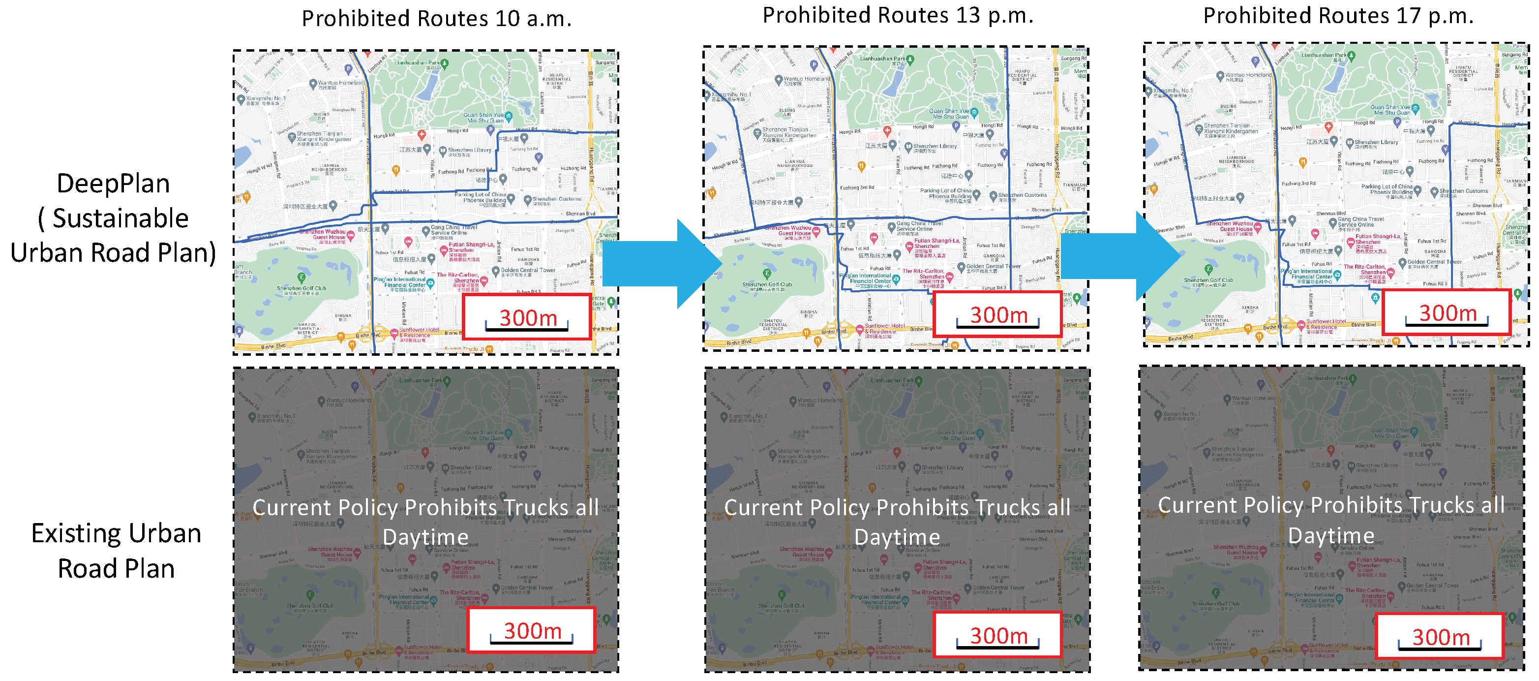
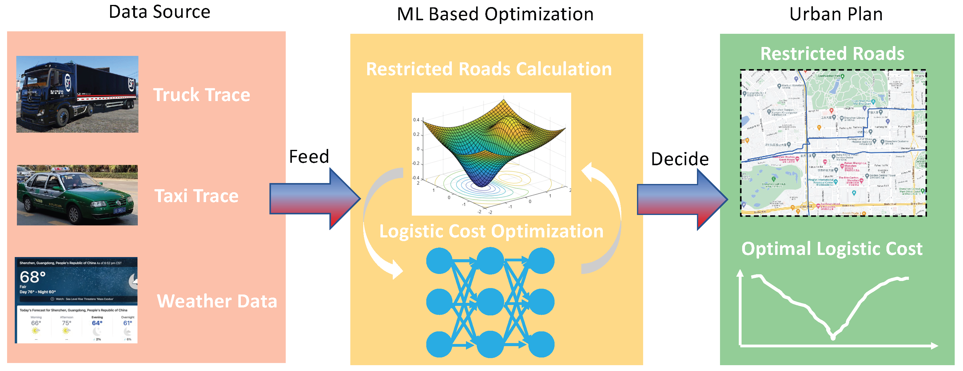
  • We propose DeepPlan, a novel urban road planning tool that optimizes the logistic costs of trucks to build a sustainable road plan. DeepPlan iteratively selects the least number of roads to ban dynamically, achieving greater effectiveness and cost-efficiency compared to the existing policy.
  • To obtain real-time logistic costs, DeepPlan applies deep-learning models to estimate the trucks’ logistic costs from the optimal route, learned from taxis’ trace data. This model precisely captures the driving pattern that can save logistic costs and deliver payloads in the shortest time.
  • We evaluate DeepPlan with the data collected in Shenzhen, China. The experimental results show that DeepPlan outperforms the existing policy by 25% and can support real-time decisions for administrators under different weather and event conditions.

2. Literature Review

Goh M (2003) [1] expounded the composition and management methods of logistics cost, and had an initial understanding of China’s logistics cost management. Wang X (2021) [2] defined five major system modules for enterprises to achieve the goal of enterprise logistics cost control: optimize logistics procedures, reduce operation time, select very low-level operation consumption, remove unnecessary operation steps, and reduce operation costs. The cost of the overall resource used. Liu W, Liang Y, Bao X, et al. (2022) [3] analyzed the cost management of logistics companies according to the background of COVID-19 in China at that time, and expounded the basic theory of cost management of logistics companies. Starting from theories and principles, Nakajima H (2012) [4] studies and analyzes the effective and specific implementation steps and methods of logistics cost management.
Ding Q, Zhao H. (2022) [5] proposed that advanced logistics technology should be used to reduce the occurrence of logistics costs. The use of modern logistics equipment can greatly help enterprises improve economic benefits and achieve the purpose of reducing costs and increasing efficiency. Liu Langui (2018) [6] believes that the rapid development of the modern logistics industry is inseparable from the support of a strong information system, and modern enterprises should use information systems to improve logistics efficiency and improve their strength. Gayialis S P, Kechagias E P, Konstantakopoulos G D. (2022) [7] proved that enterprises can improve the logistics efficiency of enterprises by improving the packaging of goods. Therefore, improving and improving packaging efficiency is an effective measure to reduce the logistics cost of enterprises. Xue J, Cui J. (2022) [8] proposed that enterprises can manage and reduce the amount of goods sold and returned by speeding up the logistics operation speed of goods, improving the entire circulation operation process of goods, improving the level of logistics service of goods, and reducing the amount of sales and returns of goods. The logistics cost of the enterprise Ju C. (2022) [9] pointed out that the slow development of the logistics industry is an obstacle to the development of e-commerce enterprises, and the development of logistics distribution mode should be accelerated to reduce logistics costs to promote the development of e-commerce. Mao H, Chen L. (2021) [10] found that e-commerce companies lack cost control means, improper logistics cost control methods, inadequate control of logistics cost for sales returns, and weak inventory cost control capabilities. Pratap S, Daultani Y, Dwivedi A, et al. (2021) [11] believed that e-commerce enterprises should strengthen cost control, especially logistics cost control, and the managers of enterprises should pay enough attention to ensure cost control through authority. The plan was implemented. Naseem M H, Yang J, Xiang Z. (2021) [12] believe that attention should be paid to the possible risks of reducing logistics costs, for example, the logistics costs of enterprises can be effectively controlled by reducing the sales return rate of e-commerce. Zhao Y, Yu Y, Shakeel P M, et al. (2021) [13] through the study of the logistics cost characteristics of e-commerce companies, it is confirmed that if the enterprise establishes a cost task center, establishes a management system and improves the working ability of employees, it can help the enterprise to control the logistics cost and management.
With the high-quality development of China’s economy for many years, the living standards of urban and rural residents across the country have been significantly improved. As a bulk consumer product, the demand for automobiles is also growing explosively [14]. According to statistics from the Traffic Management Bureau of the Ministry of Public Security, as of January 2023, the number of motor vehicles in the country has reached 417 million, of which the number of cars has reached 319 million. The huge volume of cars does not match the current road traffic resources, and the current urban road traffic cannot bear the increasing number of motor vehicles, which leads to the big city disease of traffic congestion. Pollution from mobile sources such as motor vehicles has become an important source of air pollution in my country [15]. Traffic congestion and motor vehicle exhaust emissions are the two main problems brought to the city by the substantial increase in the number of motor vehicles. The two will interact and form a vicious circle, resulting in a decline in public urban living standards. Therefore, in order to solve this problem, some developed areas have adopted a motor vehicle restriction system [16].
The motor vehicle restriction system is a measure that restricts the right of specific motor vehicles to pass in a specific time period and in a specific area [17]. It was generally considered as a policy tool to alleviate road traffic congestion and air pollution at the beginning of its implementation During the implementation of the system, it is relatively fair to specific motor vehicle users, so it is used by many countries and regions in the world.
With the rapid development of computer technology, vehicles often install sensors with positioning technology during driving, which record a large amount of Global Positioning System (GPS) path data [18]. Obtaining path data can help people better understand the geographical location of vehicles traveling [19]. The fast driving path generation algorithm can recommend the optimal driving path for drivers in a short time, and promote the development of urban transportation planning [20,21]. Traditional vehicle travel path planning methods cannot generate paths that meet different customer needs, and the speed of path recommendation is also slow. As a new planning method, the fast path generation algorithm can define the shortest path of the target and make motion planning through the point-to-point setting between spaces [22]. Based on the different nature of driving path planning scenarios, there are usually different planning modes, namely static planning and dynamic programming [23]. Static planning refers to obtaining path planning based on the surrounding environment by establishing an environmental model and inputting all data of static obstacles [24]. Dynamic programming refers to automatic driving path planning based on the environment to be confirmed by sensing the role of obstacles through sensors [25]. Urban transportation big data is based on intelligent transportation systems and analyzes the traffic data around the city. It has characteristics such as volume, velocity, diversity, veracity, connectivity, and value, namely 6V features [26]. Liu provides a specific method for monitoring urban uneven development using remote sensing images. In summary, in order to improve the shortcomings of traditional path planning, some studies have proposed deep learning based methods to explore fast generation algorithms for driving paths.
The traffic signal control system of a city has become a central node for providing data support and implementing control strategies in the process of smart transportation construction, as it includes real-time data and planning data for the entire city’s signal control operation [27,28]. Especially in the emerging application scenarios of vehicle networking and vehicle road collaboration represented by in car navigation, mining and utilizing signal timing data from signal control systems is of great significance for promoting the interconnection and openness of traffic management information, improving road traffic safety and efficiency [29]. Traditional road navigation methods usually only consider factors such as distance, time, and road conditions, while neglecting the influence of signal light control, and can only calculate the relatively optimal path under uncontrolled signal conditions [30]. When users drive based on such navigation results, they are often hindered by the control of traffic lights at intersections [31]. From the perspective of driving time and energy consumption, it is not really the optimal navigation result. With the development of car networking and internet technology, domestic navigation companies have attempted to connect with signal light data [32,33]. Through dynamic speed guidance, it ensures that vehicles stop at each light controlled intersection on the path with the least number of times, reduces vehicle delays and energy losses caused by signal light control, improves the efficiency and reliability of vehicle navigation, and can reduce tail gas emissions caused by multiple stops [34,35].
The motor vehicle restriction system was first formulated and implemented in Buenos Aires, the capital of Argentina in the 1970s. Subsequently, similar systems were implemented in the capitals of Venezuela and Chile, and gradually spread to the whole world [36]. Shanghai was the first city in China to implement the motor vehicle restriction system [37]. In December 2002, the relevant departments of the Shanghai Municipal Government introduced measures to prohibit motor vehicles with license plates from other ports from entering the elevated road during the morning and evening peak hours, which was the first domestic motor vehicle restriction system, and then according to the actual situation, it was gradually improved and is still in use today [38]. During the 2007 “Good Luck Beijing” Olympic Test Competition, Beijing implemented the odd and even number restriction system for the first time, and achieved good results [39]. Subsequently, during the 2008 Beijing Olympic Games, the motor vehicle restriction system continued to be implemented, and after several adjustments to the rules, it has been implemented until now [40].
Large-scale transport vehicles are usually responsible for transporting equipment, building materials, and fresh vegetables and fruits [41]. Due to the large amount of pollutant emissions, slow mobility, and easy urban congestion, the restriction system for large-scale transport vehicles is particularly strict [42,43]. Although the motor vehicle restriction system can improve the efficiency of urban operation and reduce air pollutant emissions, in today’s highly developed big data and cloud computing, it continues to follow the one-size-fits-all restriction system for nearly 20 years, especially for large transport vehicles. Limitation is apparently no longer tried.
The vehicle scheduling problem to be studied in this paper is also a vehicle routing problem in essence, that is, when the factors such as transportation volume, delivery time, delivery location, vehicle type and other factors are known, the shortest route, the smallest transportation cost, the least time-consuming, etc.Chen proposed a personalized path recommendation strategy that can track and study users’ path preferences. As a goal, formulate the optimal strategy. In fact, the vehicle scheduling problem was first proposed by Danzig and other scholars, mainly to solve the problem of vehicle transportation trajectory optimization in the case of the least number of vehicles. Subsequently, with the broadening of research perspectives and the updating of technologies, many scholars began to use genetic algorithms, two-stage methods and other algorithms to solve the problem of optimal vehicle routing [44]. Dynamic programming and other methods to carry out research on vehicle scheduling, trying to determine the optimal transportation path of vehicles more scientifically [45,46].

3. Material and Methods

DeepPlan aims to optimally select prohibited roads with the minimum logistic cost. Hence, in order to evaluate the logistic cost of trucks under different prohibited road plans, a logistic cost estimation is needed. However, since trucks are not allowed to enter the urban area during the daytime, there is no historical data available to show the driving pattern of trucks during the day, which poses a great challenge to estimating the logistic cost of trucks and optimizing the cost precisely during the daytime.
To handle this problem, DeepPlan leverages real-world data of traces generated by trucks and taxis in Shenzhen, China. By examining the real-world trace data, DeepPlan is able to estimate how truck drivers would drive (i.e., driving pattern) during the daytime from the trucks’ trace, which were collected at night. The intuition behind this approach consists of two parts: (i) some taxi drivers’ driving patterns are similar to those of truck drivers. By finding taxi drivers with similar patterns from the trace data collected at night, DeepPlan is able to use the taxi drivers’ daytime trace data to estimate the truck drivers’ driving pattern and routes during the day. (ii) Taxi drivers are skilled at saving cost while ensuring passengers reach their destination on time [47,48,49]. Thus, DeepPlan can optimize the logistic cost for truck drivers using the driving pattern extracted from taxi traces. Before demonstrating the detailed design of DeepPlan, the insights from the trace data are explained in the following section.

3.1. Data and Insights

DeepPlan uses multiple data sources collected in Shenzhen, China, including taxi traces, truck traces, and weather data. The taxi and truck traces are obtained from Urban Data Release V2, which is maintained by Prof. Desheng Zhang at Rutgers University (https://people.cs.rutgers.edu/~dz220/Data.html (accessed on 18 March 2023)) and historical weather data in Shenzhen (https://www.timeanddate.com/weather/china/shenzhen/historic (accessed on 18 March 2023)), respectively. Specifically, the Urban Data Release V2 contains SIM card trace data, Smartcard (Subway Swipe) data, taxi trace data, bus trace data, and truck trace data. Since DeepPlan only needs the driving pattern from taxi drivers, only taxi and truck trace data are used in this paper. In addition, the historical weather data (sunny, cloudy, windy, etc.) in Shenzhen contains all weather information tracked back to September 2009. The following table shows the data format and some sample data of taxi and truck traces (Table 1):
Here, the “Status” field indicates whether the taxi is occupied by passengers or not, and this field is not applicable (N/A) for truck trace data. The trace of trucks is much sparser than the trace of taxis because trucks are banned in the daytime and are not allowed to enter the urban area frequently in order to protect the roads [50,51,52,53,54]. In contrast, taxis can drive anywhere in the urban area they want, resulting in a dense distribution on the map. To understand the intuition behind this data, we visualize some sample data of taxi and truck traces in Figure 4. The trace of three sample trucks is much sparser than the trace of taxis because trucks are banned in the daytime and are not allowed to enter the urban area frequently in order to protect the roads [50,51,52,53,54]. In contrast, taxis can drive anywhere in the urban area they want, resulting in a dense distribution on the map.
Definition 1.
Road Segment, the set of segments of each road, separated by the road intersections, denoted by S.
Definition 2.
Trace, the set of segments, denoted by T [ s i , s i + 1 , . . s i + k ] , where s i S .
For example, T ( s o u r c e , d e s t i n a t i o n ) = [ 1 , 12 , 25 ] indicates that the trace starts at source and ends at destination, and this trace is a vector that contains segment 1, segment 12, and segment 25. With these definitions, the similarity (denoted by S i m ) of two traces can be simply formulated as follows:
S i m ( T 1 , T 2 ) = | | C S ( T 1 , T 2 ) | | 0 | | T 1 | | 0
where C S is the common subsequence of two sequences ( T 1 and T 2 trace vector in this context), and | | . | | 0 is the zero norm of a vector, which is also the length of this vector. In other words, S i m evaluates the proportion of T 2 commonly in T 1 . For instance, there are two traces T 1 ( 1 , 25 ) = [ 1 , 12 , 25 ] and T 2 ( 1 , 25 ) = [ 1 , 12 , 5 , 25 ] and they share the same source (segment 1) and destination (segment 25). Accordingly, S i m ( T 1 , T 2 ) = 1 , while S i m ( T 2 , T 1 ) = 0.75 .
To intuitively illustrate the similarity in taxi’s driving pattern and truck’s driving pattern, the similarity between one truck’s trace and 40 traces of two taxi drivers (their IDs are 22228 and 22230, and each driver contributes 20 traces) are evaluated and the corresponding results are shown in Figure 5. Specifically, the truck’s trace is from truck driver 864. The trace’s source is Baoan stadium, which is close to the Dachan Bay terminal one. And, the trace’s destination is Hexiangning Art Guan-Parking Lot in Shenzhen. The length of this truck trace is 12.1 KM. As depicted in Figure 5, some similarities are low because they might not share the same source and destination, and their patterns are very different from the truck’s trace. Fortunately, Figure 5 shows that some taxi traces have a high similarity, indicating the opportunity to use the taxi’s knowledge to estimate the truck’s behavior (trace) in daytime and further contributing to a sustainable road plan for the urbanized area, which would be explained in the next Section.
The main goal of this paper is to find a road restriction plan for trucks with the minimum cost, thereby achieving sustainability. However, achieving this goal is non-trivial due to two reasons. Firstly, estimating the minimum logistic cost for the truck driver to drive from origin to destination is challenging, as there is no previous data available showing such costs since truck drivers were never allowed to drive in daytime [55,56,57]. Secondly, the selection of prohibited or restricted roads is closely related to logistic cost optimization. Therefore, if the minimum logistic cost is difficult to calculate, the optimal prohibited roads are also hard to identify.

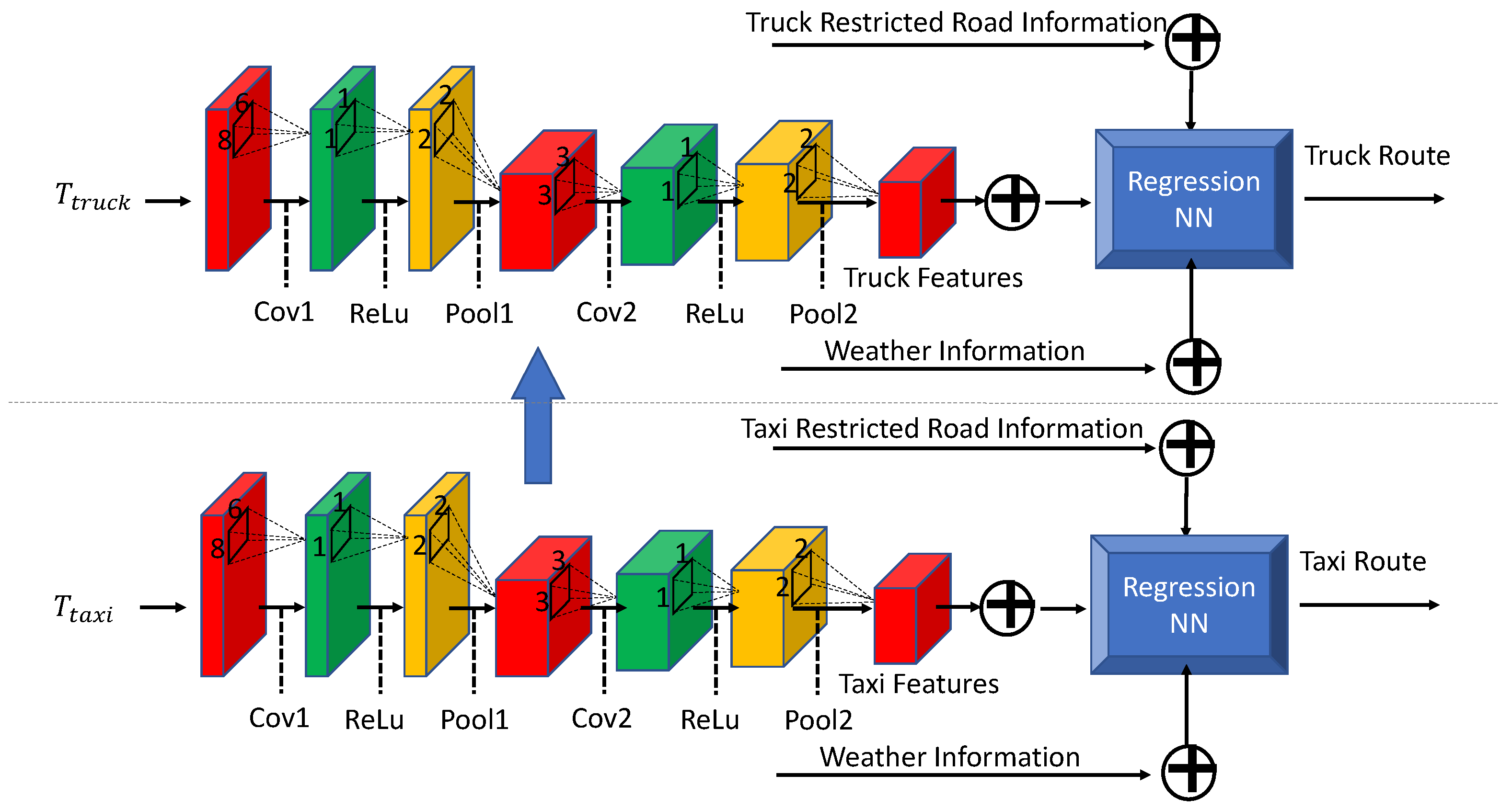
3.2. Overview of DeepPlan

In this paper, we present DeepPlan using iterative and deep learning models as illustrated in Figure 6. The architecture of DeepPlan consists of three modules: (1) Data Collection module, where truck trace, taxi trace, and weather information are collected in real-time. (2) An ML-based Optimization module, where two iterative steps are created [58,59,60,61]. Specifically, the Restricted Roads Calculation step generates the urban road plan with restricted roads. Given the restricted road information, the Logistic Cost Optimization step generates the overall logistic cost since the logistic cost varies for different urban plans [62,63,64]. (3) With the restricted roads, administrators can make decisions based on the results. The administrators can select the frequency of updating the restricted roads and obtain a real-time road plan with a minimum and sustainable urban road plan. The first module does not require any further design, while the third module only needs parameter tuning. Therefore, we will explain the detailed design of the second module in the next section [65,66].

3.3. Logistic Cost Optimization

To find the minimum logistic cost under certain restricted roads, we first attempted to use the existing navigation systems. However, the existing navigation systems, such as Google Maps and Apple Maps, are only designed for minimizing the route length or travel time, while achieving the minimum logistic cost requires both minimum travel time (petrol cost) and travel distance (wear and tear of tires and engines).
For instance, we illustrate the limitations of Google Maps and Apple Maps in Figure 7. When selecting the origin and destination, Google Maps returns either the shortest route but longer time or the shortest time but longer route. The same phenomenon also happens in Apple Maps [67,68]. Moreover, there is no interface to set the restricted roads on Google Maps and Apple Maps. This means that the existing navigation system cannot provide us with the routes with minimum logistic cost, and we cannot directly use them in the urban plan system. Therefore, this paper presents Logistic Cost Optimization, a new logistic cost-concentrated route selection system under certain restricted roads. Before showing the details of this module, we have several definitions as follows:
Definition 3.
Logistic Cost The total cost of a map, denoted by C l o g ( S r ) , where S r is the set of restricted (or prohibited) roads.
In order to minimize the logistic cost, we have the following optimization formulation:
argmin T s o l u t i o n C l o g ( S r )
where T s o l u t i o n is the optimal truck routes to satisfy all the truck delivery tasks while maintaining the minimized logistic cost under the restricted road plan S r . Specifically, C l o g ( S r ) is formulated as follows:
C l o g ( S r ) = t T s o l u t i o n c ( t )
where t is the road segment selected for trucks to finish the delivery service and c ( t ) is the logistics cost of the road segment t. To optimize the overall logistics cost, c ( t ) should be known for the trucks. However, since the trucks were never allowed to enter the urban area, there is no historical data available for the system to estimate the logistics cost for trucks. Therefore, instead of directly calculating the optimal logistics cost and routes, DeepPlan leverages the following two insights: (i) some taxi drivers’ driving patterns are similar to the truck drivers’. By finding taxi drivers with similar patterns from the trace data at night, DeepPlan is able to use the taxi driver’s daytime trace data to estimate the truck drivers’ driving patterns and routes during the daytime; (ii) taxi drivers are good at saving costs while ensuring that passengers reach their destinations on time [47,48,49]. Hence, after obtaining the optimal truck routes, the corresponding cost can be calculated, and this cost is supposed to be approximately minimum for truck drivers. Specifically, to solve this problem, we leverage an insight behind the logistics cost optimal route selection: taxi drivers are experienced in saving logistics costs, and trucks should learn from them to minimize logistics costs. The detailed deep-learning-based logistics cost optimization is achieved through the structure depicted in Figure 8.
Specifically, we optimize truck routes and minimize their overall logistics costs by learning driving patterns from taxi traces using a deep learning network. Since there is no previous data on logistics costs for trucks passing through restricted roads, especially during daytime, we leverage transfer learning to learn features from a pre-trained model on taxi data. As depicted in Figure 8, we use the weights from the pre-trained taxi model to initialize the weights of the truck model. We then obtain optimized truck routes by incorporating weather and restricted road information for trucks.
To train the taxi model, we begin by plotting candidate taxi traces in relation to their starting point and destination. The image size is set to 100 × 75 , chosen based on the urban area and map scale. Next, we feed the resulting figure into a series of layers designed to extract driving patterns. Specifically, the figure is passed through a convolution layer (Cov1), followed by a ReLU layer (ReLU), a max-pooling layer (Pool1), and another convolution layer (Cov2), followed by a ReLU layer (ReLU) and a max-pooling layer (Pool2).
Cov1 applies 64 filters with a shape of 8 × 6 and a stride of ( 4 , 3 ) , while Cov2 applies 128 filters with a shape of 3 × 3 and a stride of 1. The filter shape of Cov1 is designed based on the aspect ratio of input images, which is 4:3. We chose the filter shape of 3 × 3 for Cov2 based on its efficiency in other works, such as GoogLeNet. To determine the number of feature maps in each layer, we looped through powers of 2 from 16 to 256 and selected the ones that performed the best.
For activation functions, we used ReLUs. Both pooling layers are max-pooling layers with a shape of 2 × 2 and a stride of 2, which downsamples the data. The taxi model is trained to learn the optimized decisions of taxi drivers for selecting the optimal route plan. It is worth mentioning that the loss function is formulated as follows:
L ( T t a x i ) = t T s o l u t i o n L ( T t a x i t ) = t T s o l u t i o n | c ( t ) ^ c ( t ) |
We use the Stochastic Gradient Descent (SGD) optimization algorithm to optimize the training phase. The training of this network is achieved by the standard backpropagation procedure. At time T, the derivative of the loss L with respect to weight matrix W is expressed as follows:
L W = t T s o l u t i o n L ( T t a x i t ) W | ( T ) = t T s o l u t i o n | c ( t ) ^ c ( t ) | W | ( T )
The model is first trained on taxi data and then transferred to the truck model. We further fine tune the truck model with truck data collected on unrestricted roads. It is worth noting that with the deployment of DeepPlan, more and more truck data can be collected. With these newly collected truck data, the model can be trained iteratively, which will further optimize its performance. We also note that some roads are too narrow for trucks. To eliminate those road segments, only the road segments that were visited by trucks’ history GPS data are considered in the possible routes.

3.4. Restricted Roads Calculation

After DeepPlan obtains the logistic cost under certain restricted roads, it iteratively finds the optimal restricted roads. As shown in Figure 9, DeepPlan selects the optimal restricted roads in two steps: (1) it generates a restricted road plan, and (2) it uses this plan to minimize the logistic cost. After hundreds of iterations, it converges to an optimal plan. Specifically, this iteration can be formulated as follows:
argmin S r C l o g
To efficiently find the optimal solution, we present Algorithm 1 based on heuristics. We start by generating a random road restriction plan as the initial plan and the algorithm then iteratively reduces the logistic cost under the current plan. With Algorithm 1, DeepPlan completes its ML-based optimization. After this, the administrator obtains the optimal urban plan with the minimum logistic cost and decides the frequency of re-running DeepPlan to obtain more urban plans at different frequencies.
Algorithm 1 An algorithm for solving Equation (6)
  • Require:  S r
  •     S r randomly select road segments
  •    Calculate C l o g ( S r )
  •     C l o g ( S r ) C l o g ( S r )
  •    iteration_index 1
  •    while iteration_index ≤ number_of_iteration do
  •         iteration_index += 1
  •         if  C l o g ( S r ) C l o g 0  then
  •                S r randomly select road segments
  •               Calculate C l o g ( S r ) using S r
  •         end if
  •    end while

4. Results

4.1. Implementation

The data were collected from 26 March 2013 to 30 December 2013. We divided the data into the training set and validation set, consisting of 2/3 and 1/3 of the data, respectively. Specifically, we used the data collected from 26 March 2013 to 28 May 2013 as the training set, while using the data collected from 28 May 2013 to 30 June 2013 as the validation set.
The implementation of DeepPlan was based on the PyTorch library, with the following settings: (1) The operating system was Linux Ubuntu 18.10, with an SSD storage of 1TB and 32GB RAM memory. (2) The CPU was an Intel Core i9, and the NVIDIA RTX 3080 GPU was used for model training and testing.

4.2. Main Results

The main result is demonstrated in Figure 10. In this experiment, the truck trace and weather data on 21 June 2013 were used to generate the optimal restricted roads for that day. A practical problem about implementation is the lack of trucks’ requests to enter the urban area. In this experiment, we used the trucks’ requests at night as their demands to enter the urban area in daytime. These requests contained the source address and destination address, which were the input of DeepPlan’s deep-learning model to generate the trucks’ traces under the new prohibited road plan and the corresponding optimal logistic cost. When we ran the experiment, we uniformly distributed these requests over time (from 8 a.m. to 6 p.m.).
This result shows that at 8 a.m., the prohibited roads prevent the trucks from entering the downtown area in the urban because of the morning rush hour. Then, at 10 a.m., as the traffic becomes less crowded, more roads were open to the trucks. Later, at 12, 2, and 4 p.m., almost no road is restricted for trucks. Finally, the evening rush hour happens at 6 p.m., when the traffic was getting crowded, and trucks were prohibited on several main roads. This result suggests that fewer trucks should be allowed to enter the urban area if the traffic is already crowded.
Since the requests to enter the urban area were uniformly allocated to each hour, the mean number of such request was around 220, indicating that there were 220 trucks requested to enter the urban area every hour. Then, DeepPlan calculated the optimal road prohibition plan and found traces for each 220 entry requests. Then, we calculated the logistic cost for these traces and obtained the statistical optimal logistical cost. Correspondingly, the logistic cost for these 6 time slots was 1.54, 1.33, 0.92, 0.72, 0.77, and 1.68 US dollars per KM, which is also depicted in Figure 11. The corresponding variance is 0.05, 0.04, 0.05, 0.033, 0.04, and 0.08 US dollars per KM. This result indicates that the logistic cost increases as the traffic gets crowded. This is because the trucks usually jam the road and result in longer waiting times on the roads, leading to more gas consumption. As the minimum logistic cost reached 0.72 KM at 2 p.m., we used this value as the best result to compare with the existing policy’s result ( 0.95 /KM) and obtained a 25% performance gain. In addition, the logistic cost had already decreased below the existing policy’s result ( 0.95 /KM) after 12 p.m., and this performance gain lasted until 4 p.m. Hence, one takeaway learned from this experiment is to avoid the rush hour and send trucks in the afternoon could save cost.

4.3. How Update Frequency Affects Results

In this experiment, we evaluated the impact of road plan update frequency. For future deployment in government decision-making, how frequently to update the road plan is critical for administrators. We evaluated the logistic cost under update intervals ranging from 1 h to 6 h. To be clear, this interval between two updates of DeepPlan-generated prohibited roads is not the time of executing DeepPlan. In fact, the time spent on running DeepPlan is less than 2 s. After obtaining the new road plan, the administrator has to wait until this interval expires to publish the new road plan. Figure 12 illustrates the logistic cost over different update frequencies: 2.8, 0.72, 1.02, 1.11, 1.12 US dollars per KM and the variances were 0.1, 0.04, 0.05, 0.033, 0.04 US dollars per KM. This result indicates that it is better not to update the plan too often. This is because whenever we rerun DeepPlan and execute the road plan, it takes 30 to 60 min for the traffic to adapt to the new road plan. This delay is mainly caused by cars that were on the prohibited roads. After the administrator issues the new prohibited roads, the cars driving on them should reroute to the non-prohibited roads. If we update the road plan too frequently (e.g., every one hour), the entire traffic system would be unstable, with cars and trucks too busy rerouting to new roads and causing traffic jams. One fact leads to another, making this the worst in terms of logistic cost. From this result, we learn that updating the road plan every two hours is the optimal frequency for administrators to apply the road plan.

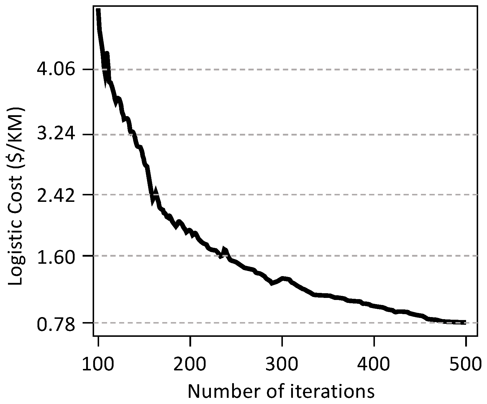
4.4. How Number of Iterations Affects Results

This experiment evaluated the time consumption of running DeepPlan. Since DeepPlan is based on the Two-step-iteration, as described in Algorithm 1, we evaluated how the number of iterations affected the result. As shown in Figure 13, the logistic cost converged to a stable status after 500 iterations, reaching the minimum logistic cost of 0.78 per KM. The average time consumed for each iteration was 2.78 milliseconds on our i9 CPU, 32 GB memory, and 3080 GPU. This indicates that the total time consumed to achieve a converged result (requiring 500 iterations) is 2.78 ms × 500 = 1.39 s. This negligible time guarantees a real-time response to the dynamic traffic.

4.5. How Weather Affects Results

We selectd three major weather conditions (SunnyCloudy, Rainy, and Foggy) and evaluated the logistic under these three different weather conditions. The corresponding results were 0.82, 1.02, 1.10 US dollars per KM and the variance were 0.05, 0.04, 0.06 US dollars per KM. We got this result because drivers prefer slowing down the trucks under the bad weather. Especially, in the foggy days, it is unsafe to drive a large truck in a high speed. Therefore, the logistic cost increased for bad weathers Figure 14).

4.6. How Events Affects Results

The dataset used in the experiments covered the Shenzhen International Marathon 2013, which was held on 7 December 2013. As the government issued more prohibited roads for the marathon event, the number of road segments for trucks decreased, resulting in different traffic behavior. In this experiment, DeepPlan also took these occasional events into account to find the optimal urban planning for trucks. Specifically, the Shenzhen International Marathon 2013 lasted around 4 h and 46 min and ended after 3:16 p.m. The overall logistic cost for this time period was 1.01/KM, as illustrated in the following figure (Figure 15):

5. Discussion

5.1. How Traffic Information Affects DeepPlan Model?

The design of DeepPlan relies mainly on taxi and truck trace data. According to the Shenzhen Transportation Association [69], there were already 20,056 taxis deployed in Shenzhen city by March 2023. This is equivalent to 17 taxis per KM 2 , indicating that taxis are densely driving in Chinese urban areas. At such high density, the taxi data already includes and reflects traffic information. Therefore, when estimating truck traces from taxi traces, the model has already taken traffic information into account. However, if the taxi trace information is not dense enough to reflect real-time traffic, the performance of DeepPlan would be significantly affected. For instance, in some Chinese suburban areas, taxis are not dense enough, and competition for the taxi market may not be severe enough to enforce taxi drivers to pursue minimum cost. Therefore, the performance gain of following these taxi driver’s traces to optimize logistic cost might be marginal.

5.2. Generalizability of DeepPlan

Since DeepPlan is based on taxi and truck trace data, its generalizability mainly depends on the quality of this data. As discussed in Section 5.1, the high density of taxis in a city is a key factor for learning driving patterns, which in turn affects the perception of DeepPlan for real-time traffic. In addition, the driving patterns of taxis differ if the taxi market is different due to low taxi density. Therefore, DeepPlan could be generalized to any metropolitan area with high taxi density. For example, Beijing has a taxi density of 24/KM 2 [70] and Shanghai has a taxi density of 16/KM 2 [71]. These two cities have similar taxi densities as Shenzhen [69,72]. Hence, applying DeepPlan to Beijing and Shanghai should achieve a noticeable reduction in logistic costs.
Another aspect of generalizability is whether DeepPlan could be extended to solve other transportation problems. The essence of DeepPlan is improving the truck prohibition plan with the help of advanced machine-learning tools and collective real-time urban traffic data. Thus, as long as we have big data support, a machine-learning based approach should be useful for providing a new way to solve traditional transportation problems.

6. Conclusions

This paper studies the urban planning problem where large trucks are not always allowed to enter urban areas. We present DeepPlan to optimally select restricted roads that do not allow trucks to enter using deep-learning and iteration-based approaches. By using DeepPlan, trucks can deliver payloads to stores at any time of the day, as opposed to being prohibited during the day according to current China’s policy. Consequently, DeepPlan not only unleashes trucks but also minimizes logistic costs, leading to a sustainable urban plan for truck drivers. The result shows that DeepPlan achieves logistic costs less than 0.78 US dollars per KM, outperforming the current policy by 25%.

Author Contributions

Z.Z. conceived and designed the research framework; H.W. (Haopeng Wang) wrote the paper and performed the experiments; Y.M. analyzed the data; H.W. (Hao Wu) and F.B. made a case study. All authors have read and agreed to the published version of the manuscript.

Funding

This research is supported by the Fundamental Research Funds for the Central Universities (No. 17CX04055B), 2021 Qingdao Social Science Planning and Research Project (No. QDSKL2101164), General scientific research project of Zhejiang Provincial Department of Education (No. Y202249620), Zhejiang Graduate Education Association (No. 2022-018).

Institutional Review Board Statement

Not applicable.

Informed Consent Statement

Not applicable.

Data Availability Statement

We obtain the public data for this paper.

Acknowledgments

We sincerely thank the editors and reviewers for their valuable comments and suggestions. We also appreciate Phoenixlab for the efforts in preparing this paper.

Conflicts of Interest

The authors declare no conflict of interest.

References

  1. Goh, M.; Ling, C. Logistics development in China. Int. J. Phys. Distrib. Logist. Manag. 2003, 33, 886–917. [Google Scholar] [CrossRef]
  2. Wang, X.; Liu, X. Intelligent logistics cost control based on microprocessor system and sensors. Microprocess. Microsyst. 2021, 82, 103801. [Google Scholar] [CrossRef]
  3. Liu, W.; Liang, Y.; Bao, X.; Qin, J.; Lim, M.K. China’s logistics development trends in the post COVID-19 era. Int. J. Logist. Res. Appl. 2022, 25, 965–976. [Google Scholar] [CrossRef]
  4. Nakajima, H. Cost Management of Logistics and Supply Chain Costs. IGI Glob. 2022, 11, 24–44. [Google Scholar] [CrossRef]
  5. Ding, Q.; Zhao, H. Study on e-commerce logistics cost control methods in the context of COVID-19 prevention and control. Soft Comput. 2021, 25, 11955–11963. [Google Scholar] [CrossRef]
  6. Perdana, Y.R. Logistics information system for supply chain of agricultural commodity. Procedia-Soc. Behav. Sci. 2012, 65, 608–613. [Google Scholar] [CrossRef]
  7. Gayialis, S.P.; Kechagias, E.P.; Konstantakopoulos, G.D. A city logistics system for freight transportation: Integrating information technology and operational research. Oper. Res. 2022, 22, 5953–5982. [Google Scholar] [CrossRef]
  8. Xue, J.; Cui, J. A cooperative game model of supply chain logistics information based on collaborative immune quantum particle swarm optimisation. Int. J. Manuf. Technol. Manag. 2022, 36, 196–212. [Google Scholar] [CrossRef]
  9. Ju, C. Research on the Challenges and Strategies of Enterprises in Reverse Logistics Cost Control Under B2C Mode. In Advances in Smart Vehicular Technology, Transportation, Communication and Applications; Springer: Singapore, 2022; pp. 401–410. [Google Scholar]
  10. Mao, H.; Chen, L. E-Commerce Enterprise Supply Chain Cost Control under the Background of Big Data. Complexity 2021, 2021, 6653213. [Google Scholar] [CrossRef]
  11. Pratap, S.; Daultani, Y.; Dwivedi, A.; Zhou, F. Supplier selection and evaluation in e-commerce enterprises: A data envelopment analysis approach. Benchmarking Int. J. 2021, 29, 325–341. [Google Scholar] [CrossRef]
  12. Naseem, M.H.; Yang, J.; Xiang, Z. Selection of Logistics Service Provider for the E-Commerce Companies in Pakistan Based on Integrated GRA-TOPSIS Approach. Axioms 2021, 10, 208. [Google Scholar] [CrossRef]
  13. Zhao, Y.; Yu, Y.; Shakeel, P.M.; Montenegro-Marin, C. Research on operational research-based financial model based on e-commerce platform. In Information Systems and e-Business Management; Springer: Berlin/Heidelberg, Germany, 2021; pp. 1–17. [Google Scholar]
  14. Huo, H.H.; Wang, M.; Johnson, L.; He, D. Projection of Chinese motor vehicle growth, oil demand, and CO2 emissions through 2050. Transp. Res. Rec. 2023, 2038, 69–77. [Google Scholar] [CrossRef]
  15. Li, Y.; Liu, Y.; Chen, Y.; Huang, S.; Ju, Y. Projection of end-of-life vehicle population and recyclable metal resources: Provincial-level gaps in China. Sustain. Prod. Consum. 2022, 31, 818–827. [Google Scholar] [CrossRef]
  16. Zhang, X.; Yang, Q.; Xu, X.; Zhang, N. Do urban motor vehicle restriction policies truly control urban air quality? Transp. Res. Part D Transp. Environ. 2022, 107, 103293. [Google Scholar] [CrossRef]
  17. Jenelius, E.; Petersen, T.; Mattsson, L.G. Importance and exposure in road network vulnerability analysis. Transp. Res. Part A Policy Pract. 2006, 40, 537–560. [Google Scholar] [CrossRef]
  18. Brosnan, R.J.; Watson, G.; Stuart, W.; Twentyman, C.; Kitic, C.M.; Schmidt, M. The validity, reliability, and agreement of global positioning system units—can we compare research and applied data? J. Strength Cond. Res. 2022, 12, 3330–3338. [Google Scholar] [CrossRef]
  19. Wang, S.; Kim, S.M.; He, T. Symbol-level cross-technology communication via payload encoding. In Proceedings of the 2018 IEEE 38th International Conference on Distributed Computing Systems (ICDCS), Vienna, Austria, 2–5 July 2018; pp. 500–510. [Google Scholar]
  20. Xu, Z.; Jiang, T.; Zheng, N. Developing and analyzing eco-driving strategies for on-road emission reduction in urban transport systems-A VR-enabled digital-twin approach. Chemosphere 2022, 305, 135372. [Google Scholar] [CrossRef]
  21. Zeng, W.; Wu, M.; Chen, P.; Cao, Z.; Xie, S. Review of shared online hailing and autonomous taxi services. Transp. B Transp. Dyn. 2023, 11, 486–509. [Google Scholar] [CrossRef]
  22. Tamizi, M.G.; Yaghoubi, M.; Najjaran, H. A review of recent trend in motion planning of industrial robots. Int. J. Intell. Robot. Appl. 2023, 1, 11–22. [Google Scholar] [CrossRef]
  23. Chai, R.; Liu, D.; Liu, T.; Tsourdos, A.; Xia, Y.; Chai, S. Deep learning-based trajectory planning and control for autonomous ground vehicle parking maneuver. IEEE Trans. Autom. Sci. Eng. 2022, 1–15. [Google Scholar] [CrossRef]
  24. Li, K.; Wang, S. Electric vehicle charging station deployment for minimizing construction cost. In Proceedings of the Big Data Analytics and Knowledge Discovery: 19th International Conference, Lyon, France, 28–31 August 2017; pp. 471–485. [Google Scholar]
  25. Duan, X.; Sun, C.; Tian, D.; Zhou, J.; Cao, D. Cooperative Lane-Change Motion Planning for Connected and Automated Vehicle Platoons in Multi-Lane Scenarios. IEEE Trans. Intell. Transp. Syst. 2023, 1–19. [Google Scholar] [CrossRef]
  26. Jin, S.J.; Abdullah, A.H.; Mokhtar, M.; Kohar, U.H.A. The Potential of Big Data Application in Mathematics Education in Malaysia. Sustainability 2022, 14, 13725. [Google Scholar] [CrossRef]
  27. Liu, Y.; Huo, L.; Wu, J.; Bashir, A.K. Swarm Learning-Based Dynamic Optimal Management for Traffic Congestion in 6G-Driven Intelligent Transportation System. IEEE Trans. Intell. Transp. Syst. 2023, 1–16. [Google Scholar] [CrossRef]
  28. Wang, W.; He, F.; Li, Y.; Tang, S.; Li, X.; Xia, J.; Lv, Z. Data information processing of traffic digital twins in smart cities using edge intelligent federation learning. Inf. Process. Manag. 2023, 60, 103171. [Google Scholar] [CrossRef]
  29. Alhilal, A.Y.; Finley, B.; Braud, T.; Su, D.; Hui, P. Street Smart in 5G: Vehicular Applications, Communication, and Computing. IEEE Access 2022, 10, 105631–105656. [Google Scholar] [CrossRef]
  30. Alshayeb, S.; Stevanovic, A.; Effinger, J.R. Investigating impacts of various operational conditions on fuel consumption and stop penalty at signalized intersections. Int. J. Transp. Sci. Technol. 2022, 11, 690–710. [Google Scholar] [CrossRef]
  31. Sumantri, V.N.; Rifai, A.I.; Ferial, F. Impact of inter-urban street lighting on users perception of road safety behavior: A Case of Jalan Majalengka-Rajagaluh. Citiz. J. Ilm. Multidisiplin Indones. 2022, 5, 703–711. [Google Scholar]
  32. Zhu, M.; Yang, H.; Liu, C.; Pu, Z.; Wang, Y. Real-time crash identification using connected electric vehicle operation data. Accid. Anal. Prev. 2022, 173, 106708. [Google Scholar] [CrossRef]
  33. Wolf, J.C.; Ma, J.; Cisco, B.; Neill, J.; Moen, B.; Jareck, C. Deriving signal performance metrics from large-scale connected vehicle system deployment. Transp. Res. Rec. 2019, 4, 36–46. [Google Scholar] [CrossRef]
  34. Ma, M.; Wu, H.; Wang, H.; Zhang, Y. Short-term and long-term prediction of coal consumption in Shandong Province-with ARIMA Model and Metabolism GM (1, 1) Model. IOP Conf. Ser. Earth Environ. Sci. 2019, 227, 042004. [Google Scholar] [CrossRef]
  35. Lu, Y.; Wang, S. Optimization of Joint Decision of Transport Mode and Path in Multi-Mode Freight. Transp. Netw. 2022, 22, 4887. [Google Scholar]
  36. Wang, L.; Xu, J.; Qin, P. Will a driving restriction policy reduce car trips?—The case study of Beijing, China. Transp. Res. Part A Policy Pract. 2014, 67, 279–290. [Google Scholar] [CrossRef]
  37. Tong, R.; Liu, J.; Wang, W.; Fang, Y. Health effects of PM2.5 emissions from on-road vehicles during weekdays and weekends in Beijing, China. Atmos. Environ. 2020, 223, 117258. [Google Scholar] [CrossRef]
  38. Chen, X.; Wu, G.; Li, D. Efficiency measure on the truck restriction policy in China: A non-radial data envelopment model. Transp. Res. Part A Policy Pract. 2019, 129, 140–154. [Google Scholar] [CrossRef]
  39. Huang, W.; Xu, X.; Hu, M.; Huang, W. A license plate recognition data to estimate and visualise the restriction policy for diesel vehicles on urban air quality: A case study of Shenzhen. J. Clean. Prod. 2022, 338, 130401. [Google Scholar] [CrossRef]
  40. Zou, C.; Wu, L.; Wang, Y.; Sun, S.; Wei, N.; Sun, B.; Ni, J.; He, J.; Zhang, Q.; Peng, J.; et al. Evaluating traffic emission control policies based on large-scale and real-time data: A case study in central China. Sci. Total Environ. 2023, 860, 160435. [Google Scholar] [CrossRef]
  41. Bibeka, A.; Songchitruksa, P.; Zhang, Y. Assessing environmental impacts of ad-hoc truck platooning on multilane freeways. J. Intell. Transp. Syst. 2021, 25, 281–292. [Google Scholar] [CrossRef]
  42. Inkinen, T.; Hamalainen, E. Reviewing truck logistics: Solutions for achieving low emission road freight transport. Sustainability 2020, 12, 6714. [Google Scholar] [CrossRef]
  43. Soto, J.J.; Macea, L.F.; Cantillo, V. Analysing a license plate-based vehicle restriction policy with optional exemption charge: The case in Cali, Colombia. Transp. Res. Part A Policy Pract. 2023, 170, 103618. [Google Scholar] [CrossRef]
  44. Xin, L.; Xu, P.; Manyi, G. Logistics distribution route optimization based on genetic algorithm. Comput. Intell. Neurosci. 2022, 2022, 8468438. [Google Scholar] [CrossRef]
  45. Marinelli, M.; Caggiani, L.; Ottomanelli, M.; Dell’Orco, M. En route truck–drone parcel delivery for optimal vehicle routing strategies. IET Intell. Transp. Syst. 2018, 12, 253–261. [Google Scholar] [CrossRef]
  46. Mohammed, M.A.; Ghani, M.K.A.; Hamed, R.I.; Mostafa, S.A.; Ahmad, M.S.; Ibrahim, D.A. Solving vehicle routing problem by using improved genetic algorithm for optimal solution. J. Comput. Sci. 2017, 21, 255–262. [Google Scholar] [CrossRef]
  47. Yuan, J.; Zheng, Y.; Xie, X.; Sun, G. T-drive: Enhancing driving directions with taxi drivers’ intelligence. IEEE Trans. Knowl. Data Eng. 2011, 1, 220–232. [Google Scholar]
  48. Leng, B.; Du, H.; Wang, J.; Li, L. Analysis of taxi drivers’ behaviors within a battle between two taxi apps. IEEE Trans. Intell. Transp. Syst. 2015, 17, 296–300. [Google Scholar] [CrossRef]
  49. Zong, F.; Wu, T.; Jia, H. Taxi drivers’ cruising patterns—Insights from taxi GPS traces. IEEE Trans. Intell. Transp. Syst. 2018, 20, 571–582. [Google Scholar] [CrossRef]
  50. Chae, Y.; Wang, S.; Kim, S.M. Exploiting WiFi guard band for safeguarded ZigBee. In Proceedings of the 16th ACM Conference on Embedded Networked Sensor Systems, Shenzhen, China, 4–7 November 2018; pp. 172–184. [Google Scholar]
  51. Bao, H.; Zhou, X.; Zhang, Y.; Li, Y.; Xie, Y. COVID-GAN: Estimating Human Mobility Responses to COVID-19 Pandemic through Spatio-Temporal Conditional Generative Adversarial Networks. In Proceedings of the SIGSPATIAL’20: 28th International Conference on Advances in Geographic Information Systems, Seattle, WA, USA, 3–6 November 2020. [Google Scholar]
  52. Willard, J.; Jia, X.; Xu, S.; Steinbach, M.; Kumar, V. Integrating Physics-Based Modeling with Machine Learning: A Survey. arXiv 2020, arXiv:2003.04919. [Google Scholar]
  53. Jia, X.; Willard, J.; Karpatne, A.; Read, J.; Zwart, J.; Steinbach, M.; Kumar, V. Physics Guided RNNs for Modeling Dynamical Systems: A Case Study in Simulating Lake Temperature Profiles. In Proceedings of the SIAM International Conference on Data Mining, Calgary, AB, Canada, 2 May 2019; Society for Industrial and Applied Mathematics Publications: Philadelphia, PA, USA, 2019. [Google Scholar]
  54. Wang, S.; Yin, Z.; Li, Z.; Chen, Y.; Kim, S.M.; He, T. Networking support for bidirectional cross-technology communication. IEEE Trans. Mob. Comput. 2019, 20, 204–216. [Google Scholar] [CrossRef]
  55. Xie, Y.; Shekhar, S.; Li, Y. Statistically-Robust Clustering Techniques for Mapping Spatial Hotspots: A Survey. ACM Comput. Surv. 2022, 55, 1–38. [Google Scholar] [CrossRef]
  56. An, Y.; Meng, S.; Wu, H. Discover Customers’ Gender From Online Shopping Behavior. IEEE Access 2022, 10, 13954–13965. [Google Scholar] [CrossRef]
  57. Jia, X.; Willard, J.; Karpatne, A.; Read, J.S.; Zwart, J.A.; Steinbach, M.; Kumar, V. Physics-Guided Machine Learning for Scientific Discovery: An Application in Simulating Lake Temperature Profiles. ACM/IMS Trans. Data Sci. 2021, 2, 1–26. [Google Scholar] [CrossRef]
  58. Xie, Y.; Bhojwani, R.; Shekhar, S.; Knight, J.F. An unsupervised augmentation framework for deep learning based geospatial object detection: A summary of results. In Proceedings of the 26th ACM SIGSPATIAL International Conference on Advances in Geographic Information Systems, Seattle, WA, USA, 6–9 November 2018. [Google Scholar]
  59. Xie, Y.; Bao, H.; Li, Y.; Shekhar, S. Discovering Spatial Mixture Patterns of Interest. In Proceedings of the SIGSPATIAL ’20: 28th International Conference on Advances in Geographic Information Systems, Seattle, WA, USA, 3–6 November 2020. [Google Scholar]
  60. Willard, J.; Jia, X.; Xu, S.; Steinbach, M.; Kumar, V. Integrating Scientific Knowledge with Machine Learning for Engineering and Environmental Systems. arXiv 2020, arXiv:2003.04919. [Google Scholar] [CrossRef]
  61. Akoglu, L.; Terzi, E.; Jia, X.; Zwart, J.; Sadler, J.; Appling, A.; Oliver, S.; Markstrom, S.; Willard, J.; Xu, S.; et al. Physics-Guided Recurrent Graph Model for Predicting Flow and Temperature in River Networks. In Proceedings of the 2021 SIAM International Conference on Data Mining (SDM), Virtual Event, 29 April–1 May 2021. [Google Scholar]
  62. Wu, H.; Gao, X.; Ma, Z.; Zhang, S. Effectiveness of production reduction policy on improving air quality in Dongying. IOP Conf. Ser. Earth Environ. Sci. 2019, 227, 052043. [Google Scholar] [CrossRef]
  63. Li, Y.; Kotwal, P.; Wang, P.; Xie, Y.; Shekhar, S.; Northrop, W. Physics-guided Energy-efficient Path Selection Using On-board Diagnostics Data. ACM Trans. Data Sci. 2020, 1, 1–28. [Google Scholar] [CrossRef]
  64. Hanson, P.C.; Stillman, A.B.; Jia, X.; Karpatne, A.; Dugan, H.A.; Carey, C.C.; Stachelek, J.; Ward, N.K.; Zhang, Y.; Read, J.S.; et al. Predicting lake surface water phosphorus dynamics using process-guided machine learning. Ecol. Model. 2020, 420, 109136. [Google Scholar] [CrossRef]
  65. Li, Y.; Xie, Y.; Wang, P.; Shekhar, S.; Northrop, W. Significant lagrangian linear hotspot discovery. In Proceedings of the SIGSPATIAL ’20: 28th International Conference on Advances in Geographic Information Systems, Seattle, WA, USA, 3–6 November 2020. [Google Scholar]
  66. Xie, Y.; Zhou, X.; Shekhar, S. Discovering Interesting Subpaths with Statistical Significance from Spatiotemporal Datasets. ACM Trans. Intell. Syst. Technol. 2020, 11, 1–24. [Google Scholar] [CrossRef]
  67. Jia, X.; Li, S.; Khandelwal, A.; Nayak, G.; Karpatne, A.; Kumar, V. Spatial Context-Aware Networks for Mining Temporal Discriminative Period in Land Cover Detection. In Proceedings of the 2019 SIAM International Conference on Data Mining (SDM), Calgary, AB, Canada, 2 May 2019. [Google Scholar]
  68. Jia, X.; Karpatne, A.; Willard, J.; Steinbach, M.; Read, J.; Hanson, P.C.; Dugan, H.A.; Kumar, V. Physics Guided Recurrent Neural Networks For Modeling Dynamical Systems: Application to Monitoring Water Temperature And Quality In Lakes. arXiv 2018, arXiv:1810.02880. [Google Scholar]
  69. Number of Taxis in Shenzhen. Available online: http://jtys.sz.gov.cn/ydmh/jtzx/tzgg_1508/content/post_10540221.html (accessed on 18 March 2023).
  70. Number of Taxis in Beijing. Available online: https://d.qianzhan.com/xdata/details/356c9d80220f0669.html (accessed on 18 March 2023).
  71. Number of Taxis in Shanghai. Available online: https://d.qianzhan.com/xdata/details/3d4f0ca64f92f51b.html (accessed on 18 March 2023).
  72. Restricted Area for Trucks in Shenzhen Urban Area. Available online: http://www.jipaihuanbao.cn/post/304931.html (accessed on 18 March 2023).
Figure 1. TheGPS data of trucks, which are from different vendors, are collected to logistic cost analysis model.
Sustainability 15 08763 g001
Figure 2. Results between DeepPlan and the existing policy in Shenzhen, China.
Sustainability 15 08763 g002
Figure 3. The logistic cost caused by the existing polity (prohibiting all trucks in daytime) and DeepPlan.
Sustainability 15 08763 g003
Figure 4. The sample trace generated by the GPS data of taxi and truck, where the truck trace is more sparse than taxi trace. (a) The GPS data of three sample trucks (ID 862-864, marked in blue, red, and black dots respectively) in Shenzhen, China. (b) The GPS data of four sample taxi (ID 22227-22230, marked in blue, red, black, and green dots respectively) in Shenzhen, China.
Sustainability 15 08763 g004
Figure 5. Correlation between truck’s (ID 864) one trace and taxis’ (taxi ID 22228 and 22230) traces.
Sustainability 15 08763 g005
Figure 6. Architecture of DeepPlan.
Sustainability 15 08763 g006
Figure 7. Navigationapplications recommend shortest (in time and spatial) route, rather than the most cost-efficient route. (a) Google Map routing result; (b) Apple Map routing result.
Sustainability 15 08763 g007
Figure 8. Deep learning model for finding the optimal truck route to minimize the logistics cost.
Sustainability 15 08763 g008
Figure 9. Iteration based approach to obtain the optimal urban plann.
Sustainability 15 08763 g009
Figure 10. Results (restricted road, marked in blue line) of urban planning, which changes every two hours in day time.
Sustainability 15 08763 g010
Figure 11. Logistics cost of DeepPlan over time.
Sustainability 15 08763 g011
Figure 12. Logistic cost for different frequencies to update road plan.
Sustainability 15 08763 g012
Figure 13. Logistics cost over the number of iterations.
Sustainability 15 08763 g013
Figure 14. Logistics cost for different weather, including sunny/cloud, rainy, and foggy.
Sustainability 15 08763 g014
Figure 15. Logistic cost when Shenzhen international Marathon 2013 happened.
Sustainability 15 08763 g015
Table 1. TAXI and Truck Trace Data Format Example.
IDTimeLatitudeLongitudeStatusSpeed
Taxi222282013/06/19 13:00:07113.95189722.556217Occupied32 KM/s
Truck8622013/06/19 20:28:28113.87680122.506849N/A10 KM/s
Disclaimer/Publisher’s Note: The statements, opinions and data contained in all publications are solely those of the individual author(s) and contributor(s) and not of MDPI and/or the editor(s). MDPI and/or the editor(s) disclaim responsibility for any injury to people or property resulting from any ideas, methods, instructions or products referred to in the content.

