Article

Resilience in Urban and Architectural Design—The Issue of Sustainable Development for Areas Associated with an Embankment

by
Agnieszka Starzyk
1,
Janusz Marchwiński
2,*,
Eliza Maciejewska
3,
Piotr Bujak
3,
Kinga Rybak-Niedziółka
1,
Magdalena Grochulska-Salak
4 and
Zdzisław Skutnik
1
1
Institute of Civil Engineering, Warsaw University of Life Sciences, 02-787 Warsaw, Poland
2
Faculty of Architecture, University of Ecology and Management, 00-792 Warsaw, Poland
3
Faculty of Civil Engineering, Warsaw University of Technology, 00-637 Warsaw, Poland
4
Faculty of Architecture, Warsaw University of Technology, 00-659 Warszawa, Poland
*
Author to whom correspondence should be addressed.
Sustainability 2023, 15(11), 9064; https://doi.org/10.3390/su15119064
Submission received: 6 May 2023 / Revised: 23 May 2023 / Accepted: 30 May 2023 / Published: 3 June 2023
(This article belongs to the Special Issue A Diversified Approach to Mitigate Crises in Urbanized Areas)

Abstract

:
The dynamically changing world poses new challenges to urbanized areas, e.g., related to water management in the architectural and urban context. Improving retention and strengthening blue-green infrastructure can be based on technical, semi-natural and natural methods, which are less invasive. Various forms are used in the city space: flow control, detention, retention, filtration, infiltration, and treatment. The implementation of the green order strategy and shaping sustainable development in the context of designing the city’s resilience is associated with shaping spatial policy and urban planning assumptions for the transformation of public spaces and new investments in urbanized areas in crisis. The shaping of waterfronts in the city and green and blue infrastructure significantly shape the parameters of the environment and the regenerative capacity of the urban ecosystem. The aim of this work was to show the relationship between the problem of embankments and the possibilities of developing space in their proximity, including areas exposed to the risk of flooding. The relationships determined by the goal were verified in comparative studies, a repeatable method of collecting, processing, analyzing, and interpreting the obtained data was used. The issue was presented in a broader context of flood risk and water management in the area of Lake Zegrze, collisions and spatial conflicts were analyzed. The results are presented in the context of detailed water management data for the complex of Riva Zegrze facilities, which is a model example regarding the sustainable development of areas on embankments, considering their specific floodplain development possibilities. The effects of the research allowed for the formulation of conclusions, including in terms of implementation, in the field of urban and architectural design for areas associated with an embankment.

1. Introduction

The rapidly changing world imposes new challenges on cities. Urban problems include energy inefficiency, poor services and inadequate infrastructure, non-optimal waste management, misuse of land and non-renewable resources, air and water pollution, technological risk, social segregation, and low safety [1]. Urban water management issues, such as water scarcity, surface water flooding and freshwater pollution, are occurring more frequently worldwide [2]. The whole range of water problems have led many countries, especially more economically developed countries (MEDCs), to cope and solve these urgent issues and integrate solutions with new urban water management strategies and practices based on the concepts of sustainable development, biodiversity, natural capital, ecosystem services, or ecosystem-based approaches, and nature-Based solutions (NBS) [3,4,5].
The European Green Deal (EGD), introduced on 1 December 2019 [6], was based on achieving climate neutrality by 2050. The EGD aims for a framework of actions to be taken by national administrations and implemented by corporations, citizens and organizations to reduce emissions and achieve carbon neutrality. The European Green Deal (EGD) was a strategy adopted by member states (MSs) to develop wealthy, resource-resilient and green economies, by prioritizing the following aspects:
(1)
Enabling Europe to become a climate-neutral continent.
(2)
Reducing pollution and enhancing the protection of human life, animals and plants.
(3)
Supporting European business communities to pioneer in green technologies.
(4)
Determining the just and inclusive segments of green and digital transition.
The European Green Deal includes among its priorities a blue infrastructure, which aims to protect biodiversity and ecosystems as well as reducing air, water and soil pollution in order to ensure the sustainability of a blue economy. In Regulation (EU) 2021/1119 of The European Parliament and The Council of 30 June 2021 [7], regarding the establishment of a framework for achieving climate neutrality, and amending Regulations (EC) No 401/2009 and (EU) 2018/1999 (European Climate Law), it is indicated that increasing climate-related health risks must be addressed, including increasingly frequent and intense heat waves, forest fires, floods, threats to food and water safety and security and the emergence and spread of infectious diseases. At the core of the action is shaping resilience to climate change, in line with the European Commission’s 24 February 2021 communication “Building a climate-resilient Europe—a new Climate Change Adaptation Strategy” [7,8,9,10,11].
European Union countries are pursuing sustainable water and urban development and transformation to achieve the Sustainable Development Goals and nature sustainability by developing strategies related to blue infrastructure and rainwater management [12].
Implementing the Green Deal strategy and shaping sustainable development in the context of designing urban resilience are related to the formation of spatial policy and urban planning guidelines for the transformation of public spaces and new investments in urbanized areas in crisis. These issues are related to the development of the re-urbanization process according to the compact smart city model.
The shaping of waterfronts in the city and green and blue infrastructure significantly shape environmental parameters and regenerative capacity in the urban ecosystem. Greenery and water elements are beneficial to residents, and society could be transformed by the efficient use of water resources [13].
The development of a water retention system is the subject of urban planning and meets the objectives of the European Green Deal, namely in terms of the criterion of the protection, preservation, and enhancement of the natural capital of the Union combined with the protection of the health and well-being of citizens from risks and negative effects associated with environmental changes. Indicating that the transformation must be equitable and inclusive underlies the formation of sustainable development.
Solutions to the problems of water shortage and pollution should be considered in terms of two aspects: increasing the availability of water and reducing the demand for water [14,15,16]. This approach is influenced by the urban demographic transformation analyzed in the context of global urbanization prospects, which should also be analyzed in the terms of urban livelihood indicators, taking into account spatial factors [17,18]. According to current studies, a 50% increase in the number of large cities exposed to water scarcity is projected, including 10–20 megacities. Most water-scarce cities can mitigate the problem by investing in infrastructure [19]. Improving retention and strengthening blue-green infrastructure can be based on technical, semi-natural and natural, i.e., less invasive methods. Various forms are used in the city space: flow control, detention, retention, filtration, infiltration and treatment.
The problem of water management in the context of the flooding of surface waters is related to global warming and frequent torrential rains. Human activity also has a negative impact—depression, lakes and water reservoirs functioning as natural water reservoirs are being destroyed by the improper use or inadequate management of coastal areas, including their inadequate development [19,20,21,22].
The idea behind this work was to examine architectural and urban solutions in areas at risk of flooding in the context of climate change. The aim of this work was to show the relationship between the problems of embankments and the possibilities of developing spaces in their proximity. The issue is presented in a broader context of flood risk and water management in the area of Lake Zegrze and based on detailed water management data for the Riva Zegrze facility complex. The subject of this article is related to the interdisciplinary approach to crisis situations in urban areas. It is part of the search for a harmonious relationship between embankments and architecture and urban planning.
However, it must be emphasized that the risk of areas behind an embankment dam being flooded is considerably lower than it is for those behind a floodbank. This is because every dam reservoir is equipped with discharge facilities, namely a bottom outlet and a safety spillway.

2. Materials and Methods

This study used a repeatable method of collecting, processing, analyzing and interpreting the obtained data [23] on development in the close vicinity of the embankments and the characteristics of the coastal area on Lake Zegrze. This issue was presented in a broader context of flood risk and water management in the area of Lake Zegrze. Data were collected on objects of a similar nature: artificial reservoirs located in Poland.
The issue of embankments and the possibility of using the potential of places that are in close proximity is the main axis of this article. Detailed data on water management were collected for the complex of Riva Zegrze facilities, which is a model example of the adopted hypothesis regarding the development of areas at embankments, taking into account their specific nature. Riva Zegrze is an apartment building designed by the architects Łukasz Barej, Rafał Bujnowski, Hubert Szczęsny and Piotr Bujak from the designing studio AKCENT. The last architect to be mentioned is one of the authors of this paper. The building is located close to the shoreline of Lake Zegrze, in the proximity of the embankment, which is a unique solution in the area of Lake Zegrze. A multiple case study was developed for the four fragments of the shoreline of Lake Zegrze, protected by the embankments. It should be added that, in Polish legislation, an embankment (Polish name: zapora boczna) is fundamentally different from a floodbank (Polish name: wał przeciwpowodziowy) in terms of the possible distances for developing the adjacent area, which is explained later in this work. The analyzed functions of the facilities in terms of their vulnerability to flooding are summarized in a comparative table in relation to flood risk.

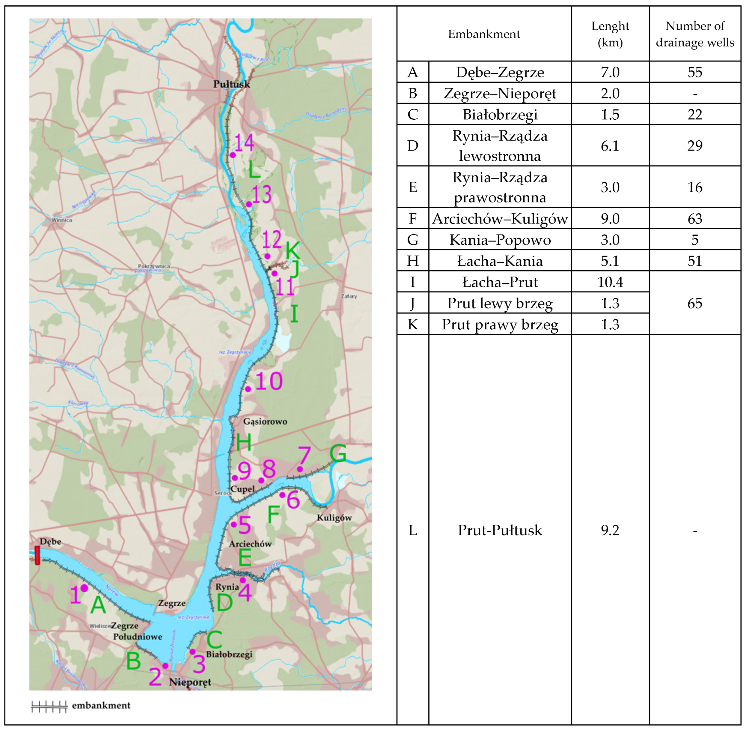
2.1. Lake Zegrze and Embankments

Lake Zegrze is an artificial reservoir located in central Poland, connected to Warsaw by the 19-kilometer-long Żerań Canal. It was created in 1963 by separating the Narew riverbed with a dam in the village of Dębe. The area of the reservoir is 3030 ha, and the capacity is 94.3 million m3. The right shoreline of the reservoir consists of a high bank of the Narew River (Figure 1).
The left banks of the Narew and Bug rivers were embanked with embankments that protect the eastern and southern parts of the catchment, including the villages of Nieporęt, Białobrzegi, Rynia and Arciechów. The embankments of Lake Zegrze have a total length of approximately 59 km. Some of the areas on the other side of the embankments are depressed in relation to the water level of Lake Zegrze. This hindered the gravitational drainage of the area. The solution turned out to be the construction of drainage wells and a system of 14 water pumping stations to the lake. The scale of this project is presented in the list of embankments along with the number of boreholes draining individual sections [25].
In the design phase, resignation from part of the embankments was considered, which would translate into a larger area of the basin. Protests from the inhabitants, who would have had to move in such a case, resulted in the abandonment of this solution. Embankments were built along with drainage ditches and pumping stations. The original protections were made of reinforced concrete slabs which were 10–12 cm thick, laid wet and dilated every 2–3 m above the turf slabs. After a few after the construction began, the ground under the slabs began to slide, which caused their deformation. Employees of the Inspectorate in Dębe strengthened them in an innovative way by filling the dams with refilled sand. The embankment was planted with wicker over a length of about 10 km. A renatured shore was created—constituting an excellent habitat for various species of birds and animals [26].
In 2021, 9 km of the embankments on the Arciechów–Kuligów section was renovated. The body and base of the embankments were sealed from the level of the existing crown over a length of 2200 m and at a depth of 7 m. The dam crown was raised over a section of 7 km, and the embankment was reconstructed (50 m, closing the section of the dam from the side of Kuligów). The entrances and exits to the dam were also reconstructed, and the embankment ditch and pavement were repaired. The cost of carrying out all the works was PLN 4.5 million [27].

2.2. Differences between an Embankment and a Floodbank

According to Article 85, Section 1, Point 4 of the Water Law Act, it is forbidden to perform “construction works consisting in the construction of building structures, digging wells, ponds, pits and ditches at a distance of less than 50 m from the foot of the floodbank on the air side”. “Building structure”, within the meaning of the Act of 7 July 1994—Construction Law, means: a building with technical installations and devices, a building constituting a technical and utility whole with installations and devices, as well as a small architectural object (Art. 3 point 1 of the Construction Law) [28]. The above legal restrictions do not apply to the embankment. There are no restrictions regarding the minimum distance that a building construction can be erected from an embankment. This is because embankment dams are equipped with outlet work appurtenances that release the water from a reservoir in order to supply water to downstream areas or to decrease the level of water in the reservoir. The differences make it possible to plan the spatial development of the areas at the embankments differently than at the floodbanks in Poland.

2.3. Anti-Flooding Importance of Lake Zegrze

The reservoir was not designed to perform a strictly anti-flood function, but it has a retention capacity resulting from the large flood area. Preemptive discharges make it possible to lower the damming level below the Min PP (MinPP = 78.52 m above sea level) and prepare a sufficiently large reserve (approximately 26 million m3). During the flood in May and June 2010, when the alert level on the Vistula River was forecast to be exceeded, actions were taken in Annopol to reduce the flood risk in the area. The water level was lowered to the minimum damming level, obtaining a flood reserve in the reservoir, which aimed to reducing discharges from the reservoir during the movement of the culminating flood wave on the Vistula. The upper water level in the reservoir was slowly lowered by 1–2 cm/h, bearing in mind the risk of landslides on the right high bank of the reservoir. Once the minimum water damming level was reached, the outflow from the reservoir was equal to the inflow, and the upper water level was close to the PP min [26].

2.4. Collisions and Spatial Conflicts

There are many collisions and spatial conflicts in the territory of the Mazowieckie Voivodship. These are a consequence of the organization of the spatial structure and primarily concern multifunctional areas where there is a natural collision of spatial development functions between urbanization pressure—the need to develop transport systems and technical infrastructure as well as the need to ensure environmental protection. One of the 8 outlined conflicts is the pressure of urbanization around Lake Zegrze, Narew and Bug, with unresolved water and sewage management. Nevertheless, in Poland, as in many other countries, the construction of any water reservoir attracts development. In such cases, a consequent policy of water and sewage management is implemented. Both gravity and pressure sewage systems are built. Examples of such reservoirs in Poland include the Świnna Poręba, Czorsztyn and Sulejów reservoirs, as well as many others where there were very high concerns regarding environmental risks. In the case of Lake Zegrze, local governments are taking care of the environment in larger settlements by introducing a wastewater management model based on a combined sewer system transporting wastewater to a central treatment plant, which has been successfully used for decades, whilst in other cases, domestic wastewater treatment plants are being installed. Spatial conflicts are usually of a social nature and result from collisions between functions and the operation of concentrating and deconcentrating factors, or the contradictory aspirations of several entities managing in a common space [29]. Despite advancing urbanization, it can be considered that Lake Zegrze is still a wild man-made water reservoir with poorly developed shores.

2.5. Analysis of Fragments of Shorelines at the Emankments of Lake Zegrze

The research question that arose during the development of the case study for the Riva Zegrze Apartments Complex was concerned with the possibility of creating facilities in close proximity to the embankments in order to determine the possibility of using the potential of these places. This area has not been previously analyzed in terms of new conditions, expectations and social standards, which include the increase in wealth and the need to invest in real estate, as well as the increasing mobility of Polish citizens and the related search for attractive tourist destinations for weekend trips. The authors of this publication see the need for research into new urban and architectural solutions in the natural context of Lake Zegrze at the current time.
An important factor conducive to the use of attractive places near Lake Zegrze is Polish legislation, in which there are no restrictions regarding the minimum distance from an embankment that a building can be erected.
The four fragments of the left-side shore of Lake Zegrze mentioned above, located at the embankments, were subjected to this study (Figure 2), namely:
The choice of the 4 aforementioned embankments out of all 12 on Lake Zegrze is related to the assessment of the attractiveness of the entire basin. The most impressive part of the lagoon, the so-called “pan”, is an area of great landscape value. The large expanse of water gives the opportunity to practice water sports, as well as develop tourism- and recreation-related industries on the waterfront. This region has the largest concentration of hotels and recreational services. Based on the analysis of existing services destined for the tourism industry, it was concluded that the area requires a deeper analysis of the possibilities of using its potential. Such a large body of water in close proximity to the capital of the country with an urban population of over 3 million is a popular destination for leisure trips. The region’s tourist base is small, consisting of a few scattered buildings. The density of urban fabric with new tourist or residential buildings seems to be needed in this place. This area could be improved for better uses with investments.
Figure 3 shows that, in the towns of Rynia and Białobrzegi, the share of shoreline protected by a side dam is the largest, amounting to 90% and 60%, respectively, and there is no flood risk in the above towns. In Zegrze Południowe and Nieporęt, embankments account for 50% and 40%, respectively, with a flood risk of 50–60%. It follows, therefore, that where there is a smaller share of embankments on the shoreline, the flood risk is higher.
As shown in Figure 4, the longest embankment is that of Rynia–Rządza, which is almost 3 km—almost equal to the length of waterfront itself. In Białobrzegi and Nieporęt, the embankments are almost 1.5 km long, and in Zegrze Południowe, the embankment is 1 km long, whilst the waterfronts are twice (Białobrzegi and Zegrze Południowe) and three times (Nieporęt) shorter. In Nieporęt, the ratio of the embankment to the length of the waterfront is the worst, whilst in Rynia–Rządza, the ratio is the best.
Comparing the data on flood risk and the percentage share of the embankment between Figure 4 and Figure 3, a certain relation of dependence can be seen. Where the share of the embankment is small, the flood risk is higher (in the case of Nieporęt and Zegrze Południowe). In order to increase the potential of places on the embankments, it would be reasonable to increase their share of the embankment (especially in Zegrze Południowe and Nieporęt) and take care of the existing ones by subjecting them to the necessary repairs and inspections. Thanks to this, the risk of hundred-year-old water would be limited. The costs associated with securing the building against possible flooding would be lower. For each area, the analysis of flood protection in a basic planning document—a local Study of Conditions and Directions of Spatial Development—is carried out. For the purpose of this analysis, the zones of (direct and indirect) flood threats are indicated. The document is usually actualized due to substantial changes in spatial planning, and then the solutions for flood protection are also included in it.
Proposals for the course of new embankment development in critical places in Nieporęt and Zegrze Południowe, under the threat of hundred-year-old water, are presented in Figure 5.
At the discussed embankments, there are buildings with various functions, mainly related to tourism and recreation, in addition to gastronomy as well as residential buildings. Polish legislation does not treat embankments (in Polish: zapora boczna) as restrictively as it does foodbanks (in Polish: wał przeciwpowodziowy). For this reason, buildings can be erected within 50 m from an embankment. Table 1 presents what kind of buildings have been erected in close proximity to the embankments. At the 4 embankments mentioned above, only 9 tourist or residential buildings were distinguished, including one which no longer existed, as well as one group of single-family houses. The buildings were analyzed in terms of the distance from the embankments and the estimated risk of flooding with hundred-year-old water. Whether these have been given special features that protect against high water can be determined based upon how the ground floors are shaped. On the basis of the analysis, further conclusions will be formulated to outline the advantages and disadvantages of the examined investments.
After analyzing the data on the development at the selected side dams, it can be assumed that:
  • There are only 8 existing tourism and residential buildings as well as a group of single-family houses on the 4 analyzed embankments.
  • It can be considered that the areas near the embankment dams have great potential in terms of touristic value, as evidenced by new investments related to tourism, gastronomy and the hotel industry. It may be considered necessary to densify the already existing urban fabric in order to create undispersed tourist areas.
  • The place where the Mazowsze Restaurant previously existed in Białobrzegi can be associated with high investment hopes. The area located close to the embankment would be perfect for a tourist or gastronomic base. There is no flood risk here. The proximity of water and green areas gives a wide range of possibilities to create an object that uses the potential of the place.
  • Existing buildings examined herein meet the requirements of local development plans related to the required shaping of building basements, e.g., raised ground floors, proximity to an embankment, etc., that minimize the risk of flooding. Basements and underground garages were abandoned by investments. Investors ensured that the foundations and anti-moisture insulations met the necessary standards of care.
  • Shaping the architecture on the embankment basically does not go beyond the framework of a classic building. However, in some investments (Apartamenty pod Żaglami, Riva Zegrze, Hotel Marina Diana), the buildings were given features which are characteristic of waterside areas, including, e.g., marine details or wooden elements resembling parts of boats or ships.
  • Many investments lack comprehensive solutions for a well-designed landscape architecture that would reduce surface run-off and increase rainwater retention. The Riva Zegrze complex uses dug wells to collect rainwater and has green roofs and green terraces. In this study area, the groundwater level is relatively low, i.e., approximately 80 cm below the ground level.
  • The problem of investments at Lake Zegrzyńskie, which also concerns many other newly built facilities in tourist areas, is related to the insufficient quality of the road infrastructure. There are also no parking spaces around the lake, so the streets are saturated with vehicles. In addition, dilapidated roads in floodplains, which have cracks, puddles and damage, could not withstand the increasing traffic volume.
  • The increasing intensity of residential development in floodplains already has and will have an increasing impact on the reduction in biologically active areas that can absorb excess water.

2.6. Land Development in the Floodplain

Drawing up a land use plan for a floodplain requires the joint effort of many specialists. In addition to architectural and urban analyses, soil, geological, water and natural conditions should also be examined.
In this work, a scheme modeled on the British Planning Policy Statement 25 (PPS 25) standards was used [30], which shows the zoning of flood risk depending on the distance from the source of the threat. Each area lying in the flood zone can be divided into areas exposed to very high, high, medium, or low flood risk. According to the hazard zone, the area should be appropriately developed (as shown in Figure 6) by adjusting the land function in terms of its sensitivity to flood damage. Using the method consisting in the selection of the terrain function corresponding to the hazard zone, the floodplain can be safely shaped using solutions that minimize the effects of flooding.
The floodplain area was divided into 4 zones based on British PPS 25 practice guide, depending on the distance from the potential flood source (Table 2). These are zones of very high (red), high (orange), medium (yellow) and low flood risk (green). They are related to the probability of flooding in a given area. In the zone most exposed to flood risk, it is 5%; in the zone of high probability, it is 1%; in the zone of medium probability, it is 0.1–1%; and in the zone with the lowest probability, it is less than 0.1%. For each of the zones, possible land functions and development opportunities were proposed. The diagram below is an example of the possible organization of the floodplain, taking into account the shaping of the architectural form of buildings and landscape architecture.
Land development in individual flood zones is related to the sensitivity of the function to flooding. Some water-related functions can be established in the zones with a very high flood risk, including river harbors with yachts and floating houses as well as sport and recreational areas with walking paths, which increase water retention capacity. In an area with a high flood risk, functions related to water and less sensitive to water, e.g., warehouse and industrial buildings, shops, restaurants, residential houses with security measures, may be established; however, educational services, schools, public buildings, hospitals, and functions of strategic importance including police, power plants may not. In the medium-risk zone, all of the aforementioned functions may be established, which may require the use of smaller or larger forms of flood protection. In areas at very high and medium flood risk, special protections for buildings against flooding may include, for example, embankments or an amphibious structure that can float during a flood, as well as buildings on stilts and waterproof buildings. The area is also shaped in a way that provides many possibilities for retention, such as ponds, seasonal watercourses, grassy areas and planting trees and shrubs to support water absorption. Rainwater is drained from the roofs of houses to surface reservoirs, and then, in the form of interesting forms of landscape architecture, it subsequently flows towards receivers (e.g., rivers). All functions can be located in the low flood risk zone, taking into account flood protection and water-resistance protections for the more vulnerable (e.g., hospitals, nursing homes, schools, police stations, and public buildings). The buildings in this zone also have green roofs and home gardens shaped in a way that allows rainwater retention and the efficient transfer of excess water to the surface rainwater drainage system. The above diagrams and table show how the floodplain can be shaped, taking into account the specificity of floodplains and how to select land functions due to their sensitivity (susceptibility) to flood damage.

3. Results

This section presents the case study of the Riva Zegrze development. It is an aparthotel-type building with residential units for rent, located on a plot of land between Lake Zegrze and Rybaki Street. The tourist infrastructure in the vicinity of Lake Zegrzyńskie is very poor. The municipality of Nieporęt, where Riva Zegrze is located, has a number of actions planned to stimulate the development of tourism infrastructure. In its development strategy for 2022–2030, the municipality envisages, among other things, investments in the area around Lake Zegrzyńskie, whilst also seeking to improve the seasonal rental offer [32].
The Riva Zegrze building consists of four, four-story ‘towers’ placed on a single-story ground floor block, comprising a garage and circulation routes. Piotr Bujak, co-author of this article, is also one of the architects of this project. The other architects are Łukasz Barej, Rafał Bujnowski and Hubert Szczęsny. This case study presents the problem of the location of the facility in an area with a particular flood risk in the immediate vicinity of the embankment. The design decisions discussed in this section were made, in part, based on the analysis, the description of which was included in Section 2. The characteristics of the existing facilities located in the vicinity of the embankments of Lake Zegrze (cited in Section 2) and the solutions adopted therein served as a catalog of potential possibilities in the field of architectural and technical solutions. In the latter aspect (the technical protection of the embankment), the most important guidelines were the recommendations issued by the embankment manager.

3.1. Landscape Conditions

The area which is the subject of this study is located in the eastern part of the Warsaw Basin mesoregion, belonging to the Central Mazovian Lowland macroregion. Three large river valleys converge within this mesoregion: Vistula, Narew, and Bug, forming the largest hydrographic junction of the country.
Moreover, it is located in a protected landscape area which, according to Polish legislation, is subject to agreement with local environmental authorities. The law also provides for special treatment for investments that may have a significant impact on the environment. This refers to facilities where the transformable area exceeds 5000 m2 [33].

3.2. Flood Risk (Surface Waters)

The project site falls under the Flood Risk Management Plan (FMP) [34] for the Vistula River basin area. According to this plan, the plot is partly located in an area of special flood risk for the Vistula River basin—this is the area between the shoreline and the embankment. Special flood risk areas are understood as areas with a medium flooding probability of 1% and areas with a high flooding probability of 10%.
Characteristic damming levels in the reservoir are as follows:
Minimum damming levelMinPP = 78.52 m above sea level Kronstadt
Normal damming levelNPP = 79.02 m above sea level Kr
Maximum damming levelMaxPP = 79.22 m above sea level Kr
Level of damming at Qp = 10%PP Q10% = 79.29 m above sea level Kr
Level of damming at Qp = 1%PP Q1% = 79.97 m above sea level Kr
The site is also situated in an area prone to flooding in the event of the destruction or damage of the Dębe–Zegrze embankment, and the level of flooding in the event of the destruction scenario of the Dębe–Zegrze embankment is 78.67 m above sea level.

3.3. Planning Regulations

The planning regulations for the area of Lake Zegrze located in the belt along the embankment allow for the establishment of tourist and recreational functions with permissible development in the form of tourist service facilities (hotels, aparthotels, guest houses). For these facilities, it is obligatory to consult design solutions with the embankment administrator. The project area is located within the boundaries of the regional masterplan (Study of Conditions and Directions of Spatial Development of the Nieporęt Municipality).
The direct neighborhood consists of areas of single-family housing with extensive residential and farm buildings, as well as recreational and leisure areas located on the banks of the Zegrzyński Reservoir. A four-story “Pod Żaglami” development with a similar function was built on Rybaki Street (Figure 7). At a distance of approximately 300 m from the plot, there are areas of residential development on Ks. K. Radziwiłł Street upon which five-story-high prefabricated residential buildings and two-story-high historical residential buildings made of brick have been erected.
Detailed regulations concerning the shape of the new development were specified by a separate decision and allowed for the construction of an apartment building with a touristic function, in the designated development zone, with a height of five stories, a total area of development and pavements on the plot not exceeding 50% of its total area, flat or multi-pitched roofs with an angle of up to 25° and a length of the front elevation not exceeding 120 m. The regulations also required that the local administrator of the Dębe embankment be consulted with regard to design solutions for flood protection.

3.4. Preliminary Analyses

The design analyses in the preliminary phase focused on solutions involving flood risk and landscape protection issues. The flood risk had to be considered in two zones: first (I) there is the area between the shoreline and the slope of the embankment (excluded from the possibility of the building location); and second (II) there is the area that lies on the other side of the barrier, within which the building was planned (Figure 8).
These zones are distinguished by the risk of flooding, which is much higher in zone I and which must be taken into account when development planning. The vegetation growing along the shoreline of Lake Zegrze is mostly wild rushes and dune grasses constituting natural shoreline reinforcement.
For zone “II”, the existing embankment is the flood protection. The flood risk maps indicate a flood level of 79.97 m above sea level in the case of the Q1% damming (once in 100 years) and 78.67 m above sea level in the case of the embankment being damaged or destroyed. In the case of the Q1% damming, this means a flood depth of up to 150 cm.
It is important to note, however, that according to the simulation shown on the flood hazard map, this is the level of damming that threatens this part of the site even if the embankment remains fully functional (Figure 9). The water in this case will flood the area on the eastern side of the non-reinforced bank of Warszawska Street. The earth embankment that forms the structure of the Warszawska Street route is interrupted by a tunnel that provides a connection to Rybaki Street (the access street to the plot under study). The embankment is therefore not sufficient to provide full protection against flooding.

3.5. Design Solutions for Flood Protection

The function of the building (tourist facility, aparthotel), which is listed in the aforementioned flood risk classification (Table 2), makes its location in a special flood risk zone acceptable. As such, it is a temporary residence, which makes it potentially easier to evacuate. However, the aim of the analyses of possible design solutions was to protect the most exposed parts of the building.

3.5.1. Adopted Solutions in Zone “I”

Zone “I” is a zone where, in addition to the analyzed damming level of Q1%, periodic flooding and inundation may also occur. The shoreline is not permanent and, depending on the water level in Lake Zegrze, it is subject to change. This is demonstrated by comparing the 2017 and 2019 maps (Figure 10).
In that case, significant intervention and the major transformation of the area was unjustified. As shown in the analysis of selected examples of investments in the vicinity of the embankment of Lake Zegrze, the shoreline arrangement consists of natural and commonly found plants in this area, such as dune grasses and rushes. The project therefore assumed limited intervention, i.e., the necessary cleaning of the area, construction of fixed and floating gangways, as well as the maintenance and possible supplementation of natural vegetation characteristic for the local landscape.
The boundary of zone ‘I’ is the scarp of the embankment, which required additional reinforcement. It was decided that the previously degraded scarp profile should be reconstructed with a ratio of 1:1.75 (height to width ratio) and that an anti-filtration screen made of bentonite-cement was to be built to protect the dam against water seepage in the case of large surges (≥Q1%). The basic parameters of the screen are as follows: depth of 10 m below the top of the embankment (70.50 m above sea level); width of 0.3–0.4 m; length of 130 m; and filtration coefficient of the screen material of k ≤ 1 × 10⁻⁶ m.

3.5.2. Selected Solutions for Zone “II”

The nature of the flood risk with the Q1% water damming scenario made the development of zone “II” particularly challenging and required the adoption of solutions providing safety for users and the building structure. As an initial scenario, we adopted a building with a ground floor in which the functional program also included hotel units (Figure 11A). In this case, the water in the Q1% damming level reached approximately half of the height of the ground floor. The second scenario examined was that of elevating the building above the danger level, with the functional program reduced to the necessary communication and parking spaces for cars in the cleared ground floor area (Figure 11B). This proposal, however, was rejected by the developer. The problem was the lack of parking facilities. An analysis of the objects located in the vicinity of the embankments of Lake Zegrze showed the necessity of elevating the most fragile parts of the planned object above the danger zone.
Eventually, a solution was decided upon, which was a synthesis of the two previously cited options, namely raising the first floor of the building with the hotel units above the danger level and locating a built-in garage on the ground floor (Figure 12). On the south side, i.e., the front of the building, the buffer for the garage is a corridor connecting the entrances to all stairwells. Above 150 cm from the floor level, i.e., the highest predicted water level of Q1%, a ribbon window was located along the corridor to provide natural light. Moreover, the possibility of making the vulnerable part of the ground floor fully watertight by constructing the foundation slab together with the garage walls in watertight concrete technology with the additional protection of the necessary openings (entrance doors) with flood curtains, activated in case of emergency, was also investigated. However, the considerable cost of such additional protection was judged to be unjustified and the decision to reduce the most vulnerable parts in the danger zone to be sufficient to adequately protect people, the building and property in the event of flooding.
A recreational area is located on the garage slab. It consists of gardens belonging to first-floor apartments. In this case, an unquestionable advantage of elevating the residential stories above the ground floor level is the view of Lake Zegrze, unobstructed by the scarp of the embankment. This also makes it possible to connect the recreational area above the garage to the embankment top by means of removable gangways (Figure 13 and Figure 14).
A separate issue that deserves consideration is rainwater management (Table 3). The site has a very limited absorption capacity due to the high level of ground water, while the planned building, in zone ‘II’, occupies more than 90% of its area. It was therefore not possible to adopt retention as the primary means of rainwater management. However, it is possible at the level of the flat roof above the garage, if a sufficiently thick soil layer is used. This will reduce the amount of rainwater to be managed from this surface to 30%. From the remaining roof surfaces, for which light non-absorbent materials (aluminum standing seam sheeting) have been provided for covering, rainwater will be collected in a tank located under the pool basin and used in part to water the greenery. The remaining part can be discharged into a drainage ditch located along the side barrier.
The amount of rainwater to be surface discharged was calculated, taking into account the occurrence of a rainfall intensity of 130 L/sxha lasting 15 min:
V = qd × t × i
where qd—quantity of rainwater for a 130 L/sxha heavy rain; t—duration of heavy rain, assumed t = 15 min = 900 s; and i—quantity of heavy rainfall.

4. Discussion

The example of Lake Zegrze presented herein is part of a broader water demand management policy, particularly important in the event of possible shortages or flood hazards [35,36,37,38]. The increase in the broadly understood risk related to water management in this area is related to the increase in the world population, the expansion of irrigation areas, economic development and severe water shortages in many regions of the world [39,40,41]. Water supply depends to a large extent on climatic, economic and political factors, which results in a high complexity of factors affecting flood risk assessment and water demand [42]. The described solutions for the design of embarkments are in line with the sustainable principles of water management. Stable water management enables a greater security and stability of water supply, and helps in adapting to climate change and reduces the depletion and degradation of water resources [43,44,45,46].
Planning embarkments is part of a broader regional water management policy. An example here is the problem of deficits in the commune of Vila Pouca de Aguiar in northern Portugal, where, in order to balance the water supply system, the study proposed its transition to conjunctive water management based on surface water being stored in small dams and groundwater [47,48,49].
The technological and material solutions presented in the project fit into the wider context of water and air pollution, indicating the possibility of changing the shape of the embankment for natural water and air purification sites with the effective use of plants in these activities, such as rushes with high parameters of transpiration and efficiency in water purification, and willows as an example of plants that catalyze harmful compounds, with the effects of cleaning the earth, water and air. The proper selection of solutions in this category requires an analysis in terms of the synergy of social and eco-system services and green and blue infrastructure. Air and water parameters and quality should also be determined by both examining the state before the changes and by specifying the parameters to be achieved by using the selected solution. The selection of solutions presented in the examples of embarkments refers to: the strategy for sustainable development, adaptation and re-urbanization. The integration of the actions specified in these three strategies is the basis for planning transformations, which can be an example of implementing Green Deal and Resilience solutions [50]. Water management related to the planning of construction investments in flood risk areas should directly refer to the policy related to the Green Deal and, in the case of urban zones, be based on the idea of a smart city [51,52,53,54]. One of the institutions dealing with these fields is the European Environmental Agency, which recognizes the adverse impacts of the physical modifications of anthropomorphic rivers not only on their ecological but also social functions (lack of accessibility of rivers and streams, lack of attractive open spaces next to water, inadequate perception of rivers by the public) and spatial and landscape functions (separation of urban spaces and rivers owing to technical infrastructure, neglected areas along rivers, blurring of the natural boundaries of urban landscapes and creating monotonous landscapes) [55]. Water policy regarding water management and restoration strategies in Europe is evidenced by the collected data: the River Wiki online database—one of the effects of the EU cross-border LIFE+ RESTORE program—contains the descriptions of over a thousand projects implemented within the EU borders; and the River Restoration Center’s (RRC) database in the same area in Great Britain recognized over 5000 completed and planned projects on this subject, among which over 3000 are available for viewing in the online database [56,57].
Water management and the flood crisis are also related to the EU Biodiversity Strategy, which assumes the protection of water resources and increasing the role of biodiversity in decision making, both in public and business matters. To this end, the strategy assumes the development of criteria and standards describing the characteristics of biodiversity, its functions, values and sustainable use. This activity must include the measuring of the carbon footprint of products and organizations, including taking into account the life cycle and accounting for natural capital, as well as in the international scope. This requires specific design solutions, which have also been used in the presented implementations, which are part of the processes of protecting the broadly understood environmental diversity [58].
Solutions for planning water management systems when planning embarkments and designing buildings on waterfronts whilst taking into account flood risk are based on various interpretations of nature-based solutions (NBSs), which constitute the basis of modern city planning in the spirit of smart city [59,60,61,62,63,64]. The indicated method of treating water resources and greenery is built in the sense of the blue and green infrastructure (BGI) structure in the sense of multi-level multi-structural resilience and controlled development processes sensitive to it, taking into account the importance of the carbon footprint in urban and architectural design [65,66,67,68,69,70,71]. The methods of the protection and modern development of the structure of water elements are related to legislative solutions and their procedural implementation in infrastructure, as in the case of the American Best Management Practices (BMP) developed since 1970 in the USA. The low-impact development system is also used there and in New Zealand (since the 1990s) [21]. In Great Britain, the Sustainable Urban Drainage System (SUDS) has been used since the 1980s [72].
Climate change, high frequency of floods in Europe, losses caused by historical floods and numerous forecasts indicate that European countries are at a significant risk of such disasters in the near future [73]. Taking this into account, flood protection is necessary and includes both technical solutions (e.g., soil protection, afforestation, construction of dams, reservoirs and river embankments) and hydrological analyses for flood forecasting (e.g., informing and alerting affected communities [74]. All flood prevention measures, including risk assessment, should lead to the reduction in flood risk and minimize the effects of flooding. Flood risk assessment is used to estimate the expected effects and probability of flooding. It leads to the strengthening of immunity through appropriate preparation for an event of a certain scale [75]. The assessment should be understood as a comprehensive, cross-sectional risk identification process, including risk analysis and assessment by determining the likelihood of various threat scenarios and their potential consequences. In the flood risk assessment procedure, after risk assessment, it is necessary to prioritize actions aiming to reduce the flood risk to an acceptable level [74,76]. In the case of flood risk in Europe, attempts to develop a risk assessment methodology were undertaken at the beginning of the 21st century, in connection with the entry into force of the Directive 2007/60/EC of the European Parliament and of the Council of 23 October 2007 on flood risk assessment and management, requiring EU member states to develop publicly available preliminary flood risk assessments, flood risk maps and flood risk management plans [77]. Detailed objectives and provisions regarding flood risk assessments are included in the Decision of the European Parliament and of the Council on the Union Civil Protection Mechanism in Article 6 [78]. European safety regulations are consistent with global regulations [79] as well as the local regulations in accordance with the legal systems of individual European countries and, apart from general guidelines on the risk assessment methodology, they also contain recommendations related to the possible threat associated with the influence of 100-year and 500-year-old water [80,81,82,83,84].
The above-mentioned legal regulations are related to global and local sustainable development policies, where the issues related to the protection of the environment and water resources are one of the key issues. The need to combine rational water management, particularly with regard to drinking water, is combined in most of the above-mentioned directives with flood risk monitoring, taking into account resilience, ecosystems and ecological protection.
Despite not having been mentioned in the text of this article thus far, many sections of flood embankments and side dams have undergone modernization works involving the sealing of the subsoil as well as the embankment. Depending on the geological structure of the subsoil and the type and condition of the soil from which the embankment is constructed, different technologies have been used. In most cases, there is a subsoil made of fine and medium sands of varying thicknesses which is relatively permeable. Therefore, in some places, anti-filtration barriers with different depths are used, the purpose of which is to increase the flow path and thus reduce the hydraulic gradients which represent a danger to the subsoil of embankments and downstream areas. In each case, the method of modernization is selected on a case-by-case manner so that its effectiveness is maximized and does not change the hydrogeological conditions of the subsoil, thus preserving the regime of water and soil conditions as well as the stability of embankments and other structures. Figure 15 shows an example of a sealing scheme for both the subsoil and the embankment [85].
The author’s project described in the results, in addition to the above-mentioned aspects regarding the protection of waterfronts and the accompanying natural environment, takes into account the need to improve the process of water retention in the river basin [86,87,88].

5. Conclusions

Despite numerous studies on embankments and blue-green architecture and the threats of climate change, such studies are generally carried out separately. The originality of this study is based on a synergistic approach to the problem. The issue was presented in a broader context of flood risk and water management in connection with architectural and urban solutions, wherein collisions and spatial conflicts were analyzed and implementation solutions were indicated. Conclusions are as follows:
  • We live in an era of urbanization and population growth, which bring with them potential opportunities and threats. The history of the development of civilization has always been one of creation at the interface between humans and nature. In today’s world, there are fewer and fewer wild places untouched by humans. However, this does not significantly apply to Lake Zegrze, which in no way resembles regulated Western European lakeside resorts. The Polish Lake Zegrze is an area of little investment, presenting a rather poor tourist base and attractions. There is a lot of wild, wet and inaccessible nature there—the so-called thickets. The Riva Zegrze, which is described in this paper, enriches areas intended for development, including tourism. It does not pose a threat to the nature at Lake Zegrze, which is in fact a man-made artificial lake.
  • The areas in the close vicinity of the embankments at the artificial Lake Zegrze analyzed herein have great investment potential, as has been shown through the nine examples of investments close to embankments and the case study of the Riva Zegrze team. Under Polish conditions, the development of the shore of Lake Zegrze is not as dynamic as in many other countries. The climate in Poland is definitely not so favorable for enjoying good weather and waterside recreation. The average wealth of Poles is also lower than that of residents in most developed countries, which translates into less opportunities to invest in luxury goods, such as a second apartment or a house by the lake. This is slowly changing and there is an increasing trend in the number of investors willing to own real estate in areas with increasing tourist potential.
  • The existing water situation in the area under development may become a contribution to the search for completely new solutions and creative interpretations in architecture and water management. This was demonstrated through the example of the Riva Zegrze project, the architects of which included one of the co-authors of this paper—Piotr Bujak. The scheme of flood hazard zones, possible functions and land development in terms of sensitivity to flood damage was presented in this paper on the basis on of Eliza Maciejewska’s research—another co-author of this publication. Taking into account groundwater, flood water or torrential rain and the associated surface run-off in the design process dictates certain limitations and therefore determines the designers’ decisions.
  • Numerous examples of new buildings erected in the vicinity of water show that, with the use of various protections, such as appropriate foundations or the location of sensitive functions on upper floors, buildings can be erected in attractive, previously difficult to access places. It should be noted that these areas are not natural habitats, but are created as a result of the construction of a reservoir such as Lake Zegrze.
  • The investment in areas at risk of flooding should be adjusted in function of the existing area. The specificity of flood zones and the selection of land functions due to their sensitivity (susceptibility) to flood damage should be taken into account, which was demonstrated through the example of Riva Zegrze. The process of floodplain development, despite the fact that it is a debatable issue, is progressing and is difficult to stop. Currently, one in six homes in the UK is in an area at risk of flooding, a proportion which is increasing. The same is happening in other countries as well. It should be emphasized that floodplains, if designed in accordance with their specific character, could be an interesting if not the only alternative for the development of cities and housing estates.
The research presented in this article presents a pioneering approach to this problem. It complements the knowledge about the dependence on embankments and the possibilities of developing spaces in their close proximity. This research may be useful for investors and designers at the stage of planning and designing investments in areas at risk of flooding.

Author Contributions

Conceptualization, A.S., J.M., E.M., P.B., K.R.-N., M.G.-S. and Z.S.; methodology, A.S., E.M. and P.B.; software, E.M. and P.B.; validation, A.S., E.M. and P.B.; formal analysis, J.M., A.S., E.M. and P.B.; investigation, A.S., E.M. and P.B.; resources, A.S., J.M., E.M., P.B., K.R.-N., M.G.-S. and Z.S.; data curation, A.S., J.M., E.M., P.B., K.R.-N. and M.G.-S.; writing—original draft preparation, A.S., E.M., P.B., K.R.-N. and M.G.-S.; writing—review and editing, A.S. and J.M.; visualization, E.M. and P.B.; supervision, A.S.; project administration, J.M. and M.G.-S. All authors have read and agreed to the published version of the manuscript.

Funding

This research received no external funding.

Institutional Review Board Statement

Not applicable.

Informed Consent Statement

Not applicable.

Data Availability Statement

Not applicable.

Conflicts of Interest

The authors declare no conflict of interest.

References

  1. Moraci, F.; Errigo, M.F.; Fazia, C.; Burgio, G.; Foresta, S. Making Less Vulnerable Cities: Resilience as a New Paradigm of Smart Planning. Sustainability 2018, 10, 755. [Google Scholar] [CrossRef] [Green Version]
  2. Chan, F.; Chuah, C.J.; Ziegler, A.; Dąbrowski, M.; Varis, O. Towards resilient flood risk management for Asian coastal cities: Lessons learned from Hong Kong and Singapore. J. Clean. Prod. 2018, 187, 576–589. [Google Scholar] [CrossRef] [Green Version]
  3. Qi, Y.; Chan, F.K.S.; Thorne, C.; O’Donnell, E.; Quagliolo, C.; Comino, E.; Pezzoli, A.; Li, L.; Griffiths, J.; Sang, Y.; et al. Addressing Challenges of Urban Water Management in Chinese Sponge Cities via Nature-Based Solutions. Water 2020, 12, 2788. [Google Scholar] [CrossRef]
  4. Marchwiński, J.; Starzyk, A.; Kopylov, O. Energy context of building materials’ use in designing energy-efficient kindergarten buildings—Architectural outlook (Kontekst energetyczny wykorzystania materiałów budowlanych w projektowaniu energoefektywnych budynków). Mater. Bud. 2022, 6, 34–38. [Google Scholar] [CrossRef]
  5. Marchwiński, J.; Starzyk, A.; Kopylov, O. Energy-efficient material solutions in the architecture of pre-school buildings (Energooszczędne rozwiązania materiałowe w architekturze budynków przedszkolnych). Mater. Bud. 2022, 8, 48–51. [Google Scholar] [CrossRef]
  6. European Commission. A European Green Deal: Striving to Be the First Climate-Neutral Continent. 2019. Available online: https://ec.europa.eu/info/strategy/priorities-2019-2024/european-green-deal_en (accessed on 5 May 2023).
  7. European Commission. Annual Sustainable Growth Strategy (ASGS) 2021; European Commission: Brussels, 2021; Available online: https://eur-lex.europa.eu/legal-content/en/TXT/?uri=CELEX%3A52020DC0575 (accessed on 5 May 2023).
  8. EU Commission. Commission Welcomes the Political Agreement on the Transitional Rules for the Common Agricultural Policy (CAP). 2022. Available online: https://ec.europa.eu/commission/presscorner/detail/en/IP_20_2236 (accessed on 5 May 2023).
  9. EU Commission. European Climate Law. 2020. Available online: https://ec.europa.eu/clima/policies/eu-climate-action/law_en (accessed on 5 May 2023).
  10. EU Commission. 2020 European Semester: Country Specific Recommendations/Commission Recommendations. 2020. Available online: https://ec.europa.eu/info/publications/2020-european-semester-country-specific-recommendations-commission-recommendations_en (accessed on 5 May 2023).
  11. European Commission. European Climate Pact Initiative/16/December 2020. Available online: https://ec.europa.eu/clima/policies/eu-climate-action/pact_en (accessed on 5 May 2023).
  12. Sachs, J.D.; Schmidt-Traub, G.; Mazzucato, M.; Messner, D.; Nakicenovic, N.; Rockstrom, J. Six Transformations to Achieve the Sustainable Development Goals. Nat. Sustain. 2019, 2, 805–814. [Google Scholar] [CrossRef]
  13. Grochulska-Salak, M. Re-urbanization in a model of sustainable development of an eco-city. Acta Sci. Pol. Arch. Bud. 2021, 20, 3–12. [Google Scholar] [CrossRef]
  14. McDonald, R.I.; Green, P.; Balk, D.; Fekete, B.M.; Revenga, C.; Todd, M.; Montgomery, M. Urban growth, climate change, and freshwater availability. Proc. Natl. Acad. Sci. USA 2011, 108, 6312–6317. [Google Scholar] [CrossRef] [Green Version]
  15. McDonald, R.I.; Weber, K.; Padowski, J.; Flörke, M.; Schneider, C.; Green, P.A.; Gleeson, T.; Eckman, S.; Lehner, B.; Balk, D.; et al. Water on an urban planet: Urbanization and the reach of urban water infrastructure. Glob. Environ. Chang. 2014, 27, 96–105. [Google Scholar] [CrossRef] [Green Version]
  16. O’Neill, B.C.; Tebaldi, C.; van Vuuren, D.P.; Eyring, V.; Friedlingstein, P.; Hurtt, G.; Knutti, R.; Kriegler, E.; Lamarque, J.-F.; Lowe, J.; et al. The Scenario Model Intercomparison Project (ScenarioMIP) for CMIP6. Geosci. Model Dev. 2016, 9, 3461–3482. [Google Scholar] [CrossRef] [Green Version]
  17. Montgomery, M.R. The urban transformation of the developing world. Science 2008, 319, 761–764. [Google Scholar] [CrossRef] [PubMed] [Green Version]
  18. United Nations. World Urbanization Prospects—Population Division; United Nations: New York, NY, USA, 2019. [Google Scholar]
  19. He, C.; Liu, Z.; Wu, J.; Pan, X.; Fang, Z.; Li, J.; Bryan, B.A. Future global urban water scarcity and potential solutions. Nat. Commun. 2021, 12, 4667. [Google Scholar] [CrossRef] [PubMed]
  20. Wang, W.W.; Wang, Q.; Lin, H.; Gong, D.J.; Zhang, S.W. Summarization and prospection for the studies on China’s urban water logging. Urban Probl. 2015, 10, 24–28. [Google Scholar]
  21. Bai, Y.; Zhao, N.; Zhang, R.; Zeng, X. Storm Water Management of Low Impact Development in Urban Areas Based on SWMM. Water 2019, 11, 33. [Google Scholar] [CrossRef] [Green Version]
  22. Amirzadeh, M.; Sobhaninia, S.; Sharifi, A. Urban resilience: A vague or an evolutionary concept? Sustain. Cities Soc. 2022, 81, 103853. [Google Scholar] [CrossRef]
  23. Nowak, S. Metodologia Badań Społecznych; Wydawnictwo Naukowe PWN: Warsaw, Poland, 2011; p. 19. [Google Scholar]
  24. Regionalny Zarząd Gospodarki Wodnej w Warszawie. Available online: https://wodypolskie.bip.gov.pl/regionalne-zarzady-gospodarki-wodnej/regionalne-zarzady-gospodarki-wodnej.html (accessed on 5 May 2023).
  25. Chowaniec, S. Zapora Dębe—Historia Powstania. Jak to Jest Zbudowane? 2017. Gazeta Powiatowa. Available online: https://gazetapowiatowa.pl/wiadomosci/serock/zapora-debe/ (accessed on 5 May 2023).
  26. Tomoń, U. Stopień Wodny Dębe—Zbiornik Wielofunkcyjny, Technologia Wody nr 15 (1/2012). Available online: https://docplayer.pl/6228700-Zbiornik-wielofunkcyjny.html (accessed on 5 May 2023).
  27. Madej, Ł. Zmodernizowano Zaporę Boczną Jeziora Zegrzyńskiego. 2021. Available online: https://inzynieria.com/geoinzynieria/wiadomosci/61267,zmodernizowano-zapore-boczna-jeziora-zegrzynskiego (accessed on 5 May 2023).
  28. Prawo Wodne. 2017. Available online: https://www.google.com.hk/url?sa=t&rct=j&q=&esrc=s&source=web&cd=&cad=rja&uact=8&ved=2ahUKEwimvrCM_aX_AhWZq1YBHU-rCkwQFnoECBYQAQ&url=https%3A%2F%2Fisap.sejm.gov.pl%2Fisap.nsf%2Fdownload.xsp%2FWDU20170001566%2FU%2FD20171566Lj.pdf&usg=AOvVaw21KSTlqRbfsRzSrx6vVT4K (accessed on 5 May 2023).
  29. Choromański, K.; Kamiński, I.; Wawer, K.; Wiszniewska, A. Analiza Funkcjonalna Zalewu Zegrzyńskiego. Instytucja Zarządzająca Programem Operacyjnym “Zrównoważony Rozwój Sektora Rybołówstwa i Nadbrzeżnych Obszarów Rybackich 2007–2013”—Minister Rolnictwa i Rozwoju Wsi. Available online: http://www.lgrzz.pl/pliki/aktualnosci/2014/Analiza_funkcjonalna_ZZ/Analiza_funkcjonalna_ZZ.pdf (accessed on 5 May 2023).
  30. Department for Communities and Local Government. Planning Policy Statement 25: Development and Flood Risk Practice Guide; Communities and Local Government Publications: London, UK, 2009.
  31. Maciejewska, E. Woda Jako Czynnik Wpływający na Kształtowanie Architektury i Krajobrazu w Dobie Zmian Klimatu. Ph.D. Thesis, Politechnika Warszawska, Warszawa, Poland, 2018. [Google Scholar]
  32. Nieporęt Commune Office. The Development Strategy of the Nieporęt Commune for 2022–2030; Nieporęt Commune Office: Warsaw, Poland, 2022; pp. 5–6. [Google Scholar]
  33. Rozporządzenie Rady Ministrów z dnia 10 Września 2019 r. w Sprawie Przedsięwzięć Mogących Znacząco Oddziaływać na Środowisko [Decree of the Council of Ministers of 10 September 2019 on Projects That May Significantly Affect the Environment] Dz. U. 2019 Item 1839. Available online: https://isap.sejm.gov.pl/isap.nsf/DocDetails.xsp?id=WDU20190001839 (accessed on 5 May 2023).
  34. Decree of the Council of Ministers of 18 October 2016 on the Acceptance of the Flood Risk Management Plan for the Vistula River Basin Area. Available online: https://www.google.com.hk/url?sa=t&rct=j&q=&esrc=s&source=web&cd=&cad=rja&uact=8&ved=2ahUKEwi_zuqN_qX_AhX-pVYBHeFKChQQFnoECBAQAQ&url=https%3A%2F%2Feur-lex.europa.eu%2FLexUriServ%2FLexUriServ.do%3Furi%3DSWD%3A2019%3A0079%3AFIN%3AEN%3APDF&usg=AOvVaw2YhxyRqlFu3FwbVfzxCAR8 (accessed on 5 May 2023).
  35. OECD. Water and Cities: Ensuring Sustainable Futures, OECD Studies on Water; OECD Publishing: Paris, France, 2015. [Google Scholar]
  36. Molinos-Senante, M.; Donoso, G. Water scarcity and affordability in urban water pricing: A case study of Chile. Util. Policy 2016, 43, 107–116. [Google Scholar] [CrossRef]
  37. Misra, A.K.; Masoodi, M.; Poyil, R.P.; Tewari, N.K. Water demand and waste management with respect to projected urban growth of Gurugram city in Haryana. Beni-Suef Univ. J. Basic Appl. Sci. 2018, 7, 336–343. [Google Scholar] [CrossRef]
  38. Doungmanee, P. The nexus of agricultural water use and economic development level. Kasetsart J. Soc. Sci. 2016, 37, 38–45. [Google Scholar] [CrossRef] [Green Version]
  39. Kifle Arsiso, B.; Mengistu Tsidu, G.; Stoffberg, G.H.; Tadesse, T. Climate change and population growth impacts on surface water supply and demand of Addis Ababa, Ethiopia. Clim. Risk Manag. 2017, 18, 21–33. [Google Scholar] [CrossRef]
  40. Udimal, T.B.; Jincai, Z.; Ayamba, E.C.; Mensah Owusu, S. China’s water situation; the supply of water and the pattern of its usage. Int. J. Sustain. Built Environ. 2017, 6, 491–500. [Google Scholar] [CrossRef]
  41. Sharma, B.; Molden, D.; Cook, S. Water use efficiency in agriculture: Measurement, current situation and trends. In Managing Water and Fertilizer for Sustainable Agricultural Intensification; International Fertilizer Industry Association (IFA): Paris, France, 2015. [Google Scholar]
  42. Han, S.; Zhou, J.; Liu, Z.; Zhang, L.; Huang, X. Influence of Community Factors on Water Saving in a Mega City after Implementing the Progressive Price Schemes. Water 2021, 13, 1097. [Google Scholar] [CrossRef]
  43. Stavenhagen, M.; Buurman, J.; Tortajada, C. Saving water in cities: Assessing policies for residential water demand management in four cities in Europe. Cities 2018, 79, 187–195. [Google Scholar] [CrossRef]
  44. Curran, S.R.; De Sherbinin, A. Completing the Picture: The Challenges of Bringing “Consumption” into the Population- Environment Equation. Popul. Environ. 2016, 26, 107–131. [Google Scholar] [CrossRef]
  45. Boholm, Å.; Prutzer, M. Experts’ understandings of drinking water risk management in a climate change scenario. Clim. Risk Manag. 2017, 16, 133–144. [Google Scholar] [CrossRef]
  46. Aubin, D.; Riche, C.; Vande Water, V.; La Jeunesse, I. The adaptive capacity of local water basin authorities to climate change: The Thau lagoon basin in France. Sci. Total Environ. 2019, 651, 2013–2023. [Google Scholar] [CrossRef]
  47. Soares, S.; Terêncio, D.; Fernandes, L.; Machado, J.; Pacheco, F.A.L. The Potential of Small Dams for Conjunctive Water Management in Rural Municipalities. Int. J. Environ. Res. Public Health 2019, 16, 1239. [Google Scholar] [CrossRef] [Green Version]
  48. Vidal Gonçalves, G.; Borges Pereira, D.; Gómez-Ullate, M.; da Silva Mano, A. Water Heritage in the Rural Hinterland Landscapes of the UNESCO Alto Douro Wine Region, Portugal: A Digital Humanities Approach. Heritage 2023, 6, 3706–3721. [Google Scholar] [CrossRef]
  49. Hu, L.; Yang, X.; Li, Q.; Li, S. Numerical simulation and Risk Assessment of Cascade Reservoir Dam-Break. Water 2020, 12, 1730. [Google Scholar] [CrossRef]
  50. Rybak-Niedziółka, K. The Origin of the Crisis in the Spatial Development of Contemporary Cities: A Review of Selected Historical and Modern Mechanisms. Sustainability 2022, 14, 10482. [Google Scholar] [CrossRef]
  51. Sokolov, A.; Veselitskaya, N.; Carabias, V.; Yildirim, O. Scenario-based identification of key factors for smart cities development policies. Technol. Forecast. Soc. Chang. 2019, 148, 119729. [Google Scholar] [CrossRef]
  52. Monfaredzadeh, T.; Berardi, U. Beneath the smart city: Dichotomy between sustainability and competitiveness. Int. J. Sustain. Build. Technol. Urban Dev. 2015, 6, 140–156. [Google Scholar] [CrossRef]
  53. Negre, E.; Rosenthal-Sabroux, C.; Gasco, M. A knowledge-based conceptual vision of the smart city. In Proceedings of the 48th Hawaii International Conference on System Science, Kauai, HI, USA, 5–8 January 2015; pp. 2317–2325. [Google Scholar] [CrossRef] [Green Version]
  54. Plieninger, T.; Draux, H.; Fagerholm, N.; Bieling, C.; Bürgi, M.; Kizos, T.; Kuemmerle, T.; Primdahl, J.; Verburg, P.H. The driving forces of landscape change in Europe: A systematic review of the evidence. Land Use Policy 2016, 57, 204–214. [Google Scholar] [CrossRef] [Green Version]
  55. EEA. Rivers and Lakes in European Cities Past and Future Challenges, Technical Report No. 26/2016; European Environment Agency: Copenhagen, Denmark, 2016. [Google Scholar] [CrossRef]
  56. River Restoration Centre, National River Restoration Inventory, River Restoration Centre Website. 2021. Available online: https://www.therrc.co.uk/ (accessed on 23 December 2022).
  57. Langie, K.; Rybak-Niedziólka, K. Renaturisation of local rivers in city landscape, based on Sokolowka Trail Valley design. Desalination Water Treat. 2021, 232, 387–403. [Google Scholar] [CrossRef]
  58. Communication from the Commission, The European Green Deal, COM (2019) 640 Final, Brussels, 2019 in Portal Internetowy EUR-Lex. Available online: https://eur-lex.europa.eu/legal-content/EN/TXT/?qid=1576150542719&uri=COM%3A2019%3A640%3AFIN (accessed on 21 December 2022).
  59. Baldi, G.; Megaro, A.; Carrubbo, L. Small-Town Citizens’ Technology Acceptance of Smart and Sustainable City Development. Sustainability 2023, 15, 325. [Google Scholar] [CrossRef]
  60. Zhang, D.; Sial, M.S.; Ahmad, N.; Filipe, A.J.; Thu, P.A.; Zia-Ud-Din, M.; Caleiro, A.B. Water Scarcity and Sustainability in an Emerging Economy: A Management Perspective for Future. Sustainability 2021, 13, 144. [Google Scholar] [CrossRef]
  61. Cettner, A.; Ashley, R.; Hedström, A.; Viklander, M. Sustainable development and urban stormwater practice. Urban Water J. 2014, 11, 185–197. [Google Scholar] [CrossRef]
  62. Kabisch, N.; Frantzeskaki, N.; Pauleit, S.; Naumann, S.; Davis, M.; Artmann, M.; Haase, D.; Knap, S.; Korn, H.; Stadler, J.; et al. Nature-based solutions to climate change mitigation and adaptation in urban areas: Perspectives on indicators, knowledge gaps, barriers, and opportunities for action. Ecol. Soc. 2016, 21, 39. [Google Scholar] [CrossRef] [Green Version]
  63. Ribeiro, P.J.G.; Pena Jardim Gonçalves, L.A. Urban resilience: A conceptual framework. Sustain. Cities Soc. 2019, 50, 101625. [Google Scholar] [CrossRef]
  64. Dushkova, D.; Haase, D. Not Simply Green: Nature-Based Solutions as a Concept and Practical Approach for Sustainability Studies and Planning Agendas in Cities. Land 2020, 9, 19. [Google Scholar] [CrossRef] [Green Version]
  65. Ghofrani, Z.; Sposito, V.; Faggian, R. A Comprehensive Review of Blue-Green Infrastructure Concepts. Int. J. Environ. Sustain. 2017, 6, 15–36. [Google Scholar] [CrossRef]
  66. Wu, T.; Song, H.; Wang, J.; Friedler, E. Framework, Procedure, and Tools for Comprehensive Evaluation of Sustainable Stormwater Management: A Review. Water 2020, 12, 1231. [Google Scholar] [CrossRef]
  67. O’Donnell, E.; Thorne, C.; Ahilan, S.; Arthur, S.; Birkinshaw, S.; Butler, D.; Dawson, D.; Everett, G.; Fenner, R.; Glenis, V.; et al. The blue-green path to urban flood resilience. Blue-Green Syst. 2019, 2, 28–45. [Google Scholar] [CrossRef] [Green Version]
  68. Kapetas, L.; Fenner, R. Integrating blue-green and grey infrastructure through an adaptation pathways approach to surface water flooding. Philos. Trans. R. Soc. A Math. Phys. Eng. Sci. 2020, 378, 20190204. [Google Scholar] [CrossRef] [PubMed] [Green Version]
  69. Rosenzweig, C.; Solecki, W.D.; Hammer, S.A.; Mehrotra, S. (Eds.) Climate Change and Cities: Second Assessment Report of the Urban Climate Change Research Network; Cambridge University Press: Cambridge, UK, 2018. [Google Scholar]
  70. Pardo-Bosch, F.; Aguado, A.; Pino, M. Holistic model to analyzeand prioritize urban sustainable buildings for public services. Sustain. Cities Soc. 2019, 4, 227–236. [Google Scholar] [CrossRef]
  71. Guerry, A.D.; Polasky, S.; Lubchenco, J.; Chaplin-Kramer, R.; Daily, G.C.; Griffin, R.; Ruckelshaus, M.; Bateman, I.J.; Duraiappah, A.; Elmqvist, T.; et al. Natural capital and ecosystem services informing decisions: From promise to practice. Proc. Natl. Acad. Sci. USA 2015, 112, 7348–7355. [Google Scholar] [CrossRef] [Green Version]
  72. Duan, Y.; Xiong, J.; Cheng, W.; Li, Y.; Wang, N.; Shen, G.; Yang, J. Increasing Global Flood Risk in 2005–2020 from a Multi-Scale Per-spective. Remote Sens. 2022, 14, 5551. [Google Scholar] [CrossRef]
  73. Kundzewicz, Z.W.; Kanae, S.; Seneviratne, S.I.; Handmer, J.; Nicholls, N.; Peduzzi, P.; Mechler, R.; Bouwer, L.M.; Arnell, N.; Mach, K.; et al. Flood risk and climate change: Global and regional perspectives. Hydrol. Sci. J. 2014, 59, 1–28. [Google Scholar] [CrossRef] [Green Version]
  74. van Herk, S.; Rijke, J.; Zevenbergen, C.; Ashley, R. Understanding the transition to integrated flood risk management in the Netherlands. Environ. Innov. Soc. Transit. 2015, 15, 84–100. [Google Scholar] [CrossRef]
  75. Bralewski, A.; Bralewska, K. Publicly Available Data-Based Flood Risk Assessment Methodology: A Case Study for a Floodplain in Poland. Water 2022, 14, 61. [Google Scholar] [CrossRef]
  76. Kanchan, M.; Rajiv, S. Flood risk assessment in the Kosi megafan using multi-criteria decision analysis: A hydro-geomorphic approach. Geomorphology 2020, 350, 106861. [Google Scholar]
  77. European Parliament and of the Council. Directive 2007/60/EC of the European Parliament and of the Council of 23 October 2007 on the Assessment and Management of Flood Risks 2007. (OJ L 288, 6.11.2007, pp. 27–34). Available online: https://eur-lex.europa.eu/eli/dir/2007/60/oj (accessed on 23 December 2022).
  78. Decision No 1313/2013/EU of the European Parliament and of the Council of 17 December 2013 on a Union Civil Protection Mechanism. Available online: https://eur-lex.europa.eu/legal-content/EN/TXT/?uri=celex%3A32013D1313 (accessed on 23 December 2022).
  79. Public Safety Canada. All Hazards Risk Assessment Methodology Guidelines 2012–2013; Public Safety Canada: Ottawa, ON, Canada, 2012. [Google Scholar]
  80. National Directorate for Fire and Emergency Manage. A Framework for Major Emergency Management; National Directorate for Fire and Emergency Manage: Dublin, Ireland, 2010. [Google Scholar]
  81. Federal Office of Civil Protection and Disaster Assistance. Method of Risk Analysis for Civil. Protection; Federal Office of Civil Protection and Disaster Assistance: Bonn, Germany, 2011. [Google Scholar]
  82. Eriksson, J.; Juhl, A.K. Guide to Risk and Vulnerability Analyses; Swedish Civil Contignencies Agency (MSB): Karlstad, Sweden, 2012. [Google Scholar]
  83. Ministry of Security and Justice. Working with Scenarios, Risk Assessment and Capabilities in the National Safety and Security Strategy of the Netherlands; Ministry of Security and Justice: The Hague, The Netherlands, 2014. [Google Scholar]
  84. Cabinet Office. National Risk Register; Cabinet Office: London, UK, 2021. [Google Scholar]
  85. Skutnik, Z.; Bajda, M.; Lech, M. The selection of sealing technologies of the subsoil and hydrotechnical structures and quality assurance. Open Eng. 2019, 9, 420–427. [Google Scholar] [CrossRef]
  86. Rybak-Niedziólka, K.; Grochulska-Salak, M.; Maciejewska, E. Resilience of riverside areas as an element of the green deal strategy—Evaluation of waterfront models in relation to re-urbanization and the city landscape of Warsaw. Desalination Water Treat. 2021, 232, 357–371. [Google Scholar] [CrossRef]
  87. Marchwiński, J. Greenery in ecological buidlings’ design and their surroundings (Zieleń w ekologicznym projektowaniu budynków i ich otoczenia). Zieleń Miejska 2013, 3. Available online: https://portalkomunalny.pl/plus/artykul/zielen-w-ekologicznym-projektowaniu-budynkow-i-ich-otoczenia/ (accessed on 20 December 2022).
  88. Addanki, C.; Venkataraman, H. Greening the economy: A review of urban sustainability measures for developing new cities. Sustain. Cities Soc. 2017, 32, 1–8. [Google Scholar] [CrossRef]
Figure 1. Zegrzyńskie Lake with marked embankments (letters A–L in green color) and pumping stations (numbers 1–14 in pink color). Data from the Regional Water management Board (RZGW) of Warsaw [24].
Sustainability 15 09064 g001
Figure 2. Zegrzyńskie Lake with marked embankments: A—Dębe–Zegrze embankment; B—Zegrze–Nieporęt embankment; C—Białobrzegi embankment; and D—Rynia–Rządza left-side embankment.
Sustainability 15 09064 g002
Figure 3. The percentage share of the waterfront protected by the embankment and the percentage share of the waterfront at risk of flooding.
Sustainability 15 09064 g003
Figure 4. The length of the embankment in relation to the length of the waterfront.
Sustainability 15 09064 g004
Figure 5. The proposed course of the embankment.
Sustainability 15 09064 g005
Figure 6. Scheme of floodplain development divided into flood hazard zones based on the British RIBA Planning Policy Statement 25 (PPS 25), based on E. Maciejewska—an author of this paper [31].
Sustainability 15 09064 g006
Figure 7. The area of the study plot specifying the most important elements: Lake Zegrze, the embankment and Rybaki street.
Sustainability 15 09064 g007
Figure 8. The zoning based on flood risk. Shown herein are the Q1% damming levels for zones “I” and “II” and the flooding of zone “II” in the event of the damage or destruction of an embankment.
Sustainability 15 09064 g008
Figure 9. Simulated flooding of the site according to the flood risk map for a damming level of Q1% (once in 100 years).
Sustainability 15 09064 g009
Figure 10. Comparison of the shoreline changes according to the 2017 and 2019 maps.
Sustainability 15 09064 g010
Figure 11. (A,B) Analysis of the possibility of locating buildings in zone “II” with water damming level Q1%.
Sustainability 15 09064 g011
Figure 12. Cross-section scheme of the RIVA ZEGRZE building with the garage and corridor located on the ground floor.
Sustainability 15 09064 g012
Figure 13. Scheme of plot development RIVA ZEGRZE, designers: Łukasz Barej, Piotr Bujak, Rafał Bujnowski and Hubert Szczęsny.
Sustainability 15 09064 g013
Figure 14. Bird’s-eye view from the north-west, designers: Łukasz Barej, Piotr Bujak, Rafał Bujnowski and Hubert Szczęsny.
Sustainability 15 09064 g014
Figure 15. A view of the flood embankment modernization. Connection of Geosyntetic Clay Liner (GCL) with the cut-off wall.
Sustainability 15 09064 g015
Table 1. Analyzed buildings near four chosen embankments.
EmbankmentEstimated Distance from EmbankmentBasement of the BuildingNumber of Stories Flood Risk 1% (100-Year-Old Water)Parking
Sustainability 15 09064 i001
Dębe–Zegrze
1. Riva Zegrze—apartment building
20 m
-
No residential functions on the ground floor.
-
Services
-
Parking
4 50% of the investment
-
Above-ground car parks
2. Apartamenty pod Żaglami—apartment building
60 m
-
No residential functions on the ground floor
-
Less sensitive functions: parking, services
3100% of the investment
-
Parking spaces in the garage on ground floor
3. Harbor “Przy Starym Moście”—service building
15–30 m
-
Building is located on a natural hill
1-
-
Above-ground car parks
Sustainability 15 09064 i002
Zegrze–Nieporęt
4. Szafran Residence
50–60 m in front of the embankment
-
elevation, artificial hill
3-
-
Above-ground car parks
5. Magnacka Guest Room
15–20 m in front of the embankment
-
elevation, artificial hill
-
Wall from the side of the lake
2-
-
Above-ground car parks
Sustainability 15 09064 i003
Białobrzegi
6. No longer exists—Mazowsze Restaurant
15 mOnce a popular restaurant during the period 1970–2005, and now a recreational place with great potential2--
7. IRSS training center
45–50 m
-
Reception and restaurant in the ground floor
7-
-
Above-ground car parks
8. Hotel Marina Diana
40–45 m
-
Reception and restaurant in the ground floor
-
Raised plot area
3-
-
Above-ground car parks
Sustainability 15 09064 i004
Rynia–Rządza
9. Rewita Rynia
ca. 80–100 m
-
Reception and restaurant in the ground floor
-
Raised plot area
2–6-
-
Above-ground car parks
10. Single-family house in Rynia
Ca. 15–50 m
-
Typical single family houses
1–3-
-
Built-in and freestanding garages
Table 2. Flood hazard zones, possible functions and land development opportunities in terms of the sensitivity to flood damage. Colored balls indicate acceptable functions and land development: green—allowed function, yellow—flood protection required, orange—flood and extra protection required, red—avoid use, based on E. Maciejewska—an author of this paper.
Flood ZoneProbability of FloodingAcceptable Functions and Land Development
Connected with WaterLess Sensitive to FloodingSensitive and Very Sensitive to Flooding
Sustainability 15 09064 i005Sustainability 15 09064 i006Sustainability 15 09064 i007Sustainability 15 09064 i008Sustainability 15 09064 i009Sustainability 15 09064 i010Sustainability 15 09064 i011Sustainability 15 09064 i012Sustainability 15 09064 i013Sustainability 15 09064 i014
1. Low flood riskLower than once every 1000 years (less than 0.1%)Sustainability 15 09064 i015Sustainability 15 09064 i015Sustainability 15 09064 i015Sustainability 15 09064 i015Sustainability 15 09064 i015Sustainability 15 09064 i016Sustainability 15 09064 i016Sustainability 15 09064 i016Sustainability 15 09064 i016Sustainability 15 09064 i016
2. Medium flood riskIn the range of once every 1000–100 years (0.1–1%), from river waters; once every 200 years (0.5%) from the seaSustainability 15 09064 i015Sustainability 15 09064 i015Sustainability 15 09064 i015Sustainability 15 09064 i016Sustainability 15 09064 i016Sustainability 15 09064 i016Sustainability 15 09064 i017Sustainability 15 09064 i017Sustainability 15 09064 i017Sustainability 15 09064 i017
3a. High flood riskMore than once every 100 years (1%) from river waters; more than once every 200 years (0.5%) from the sea.Sustainability 15 09064 i015Sustainability 15 09064 i015Sustainability 15 09064 i015Sustainability 15 09064 i017Sustainability 15 09064 i017Sustainability 15 09064 i017Sustainability 15 09064 i017Sustainability 15 09064 i018Sustainability 15 09064 i018Sustainability 15 09064 i018
3b. Very high flood riskGreater than once every 20 years (5%)—floodplainsSustainability 15 09064 i015Sustainability 15 09064 i015Sustainability 15 09064 i015Sustainability 15 09064 i018Sustainability 15 09064 i018Sustainability 15 09064 i018Sustainability 15 09064 i018Sustainability 15 09064 i018Sustainability 15 09064 i018Sustainability 15 09064 i018
1. Allowed functionSustainability 15 09064 i015 3. Flood and extra protection required Sustainability 15 09064 i017
2. Flood protection requiredSustainability 15 09064 i016 4. Avoid useSustainability 15 09064 i018
Sustainability 15 09064 i005Development of ports, quays, marinasSustainability 15 09064 i009Shops, restaurantsSustainability 15 09064 i011Residential development
Sustainability 15 09064 i021Open spaces, buffer parks, agricultureSustainability 15 09064 i008Industrial and warehouse buildingsSustainability 15 09064 i013Educational services, schools, public buildings
Sustainability 15 09064 i022Recreational areas, physical activitySustainability 15 09064 i019Hotels, boarding housesSustainability 15 09064 i012Hospitals, nursing homes
Sustainability 15 09064 i007Transport—car parks, reloading hallsSustainability 15 09064 i020Offices, business centersSustainability 15 09064 i014Strategic services: police, power plant
Table 3. Rainwater balance.
Type of SurfaceArea (m2)Run-Off RatioRainwater Quantity for Rain
130 L/sxha
Rainwater Quantity for Rain
300 L/sxha
Green roof00.300
Metal roof1584.00.918.542.8
Terraces on fourth floor 472.90.95.512.8
Green terraces622.50.32.45.6
Paved area178.80.81.94.3
Total28.3565.43
Disclaimer/Publisher’s Note: The statements, opinions and data contained in all publications are solely those of the individual author(s) and contributor(s) and not of MDPI and/or the editor(s). MDPI and/or the editor(s) disclaim responsibility for any injury to people or property resulting from any ideas, methods, instructions or products referred to in the content.

