Article

Dynamic Changes in Agroecosystem Landscape Patterns and Their Driving Mechanisms in Karst Mountainous Areas of Southwest China: The Case of Central Guizhou

School of Geography and Environmental Sciences, Guizhou Normal University, Guiyang 550001, China
*
Author to whom correspondence should be addressed.
Sustainability 2023, 15(12), 9160; https://doi.org/10.3390/su15129160
Submission received: 28 April 2023 / Revised: 26 May 2023 / Accepted: 31 May 2023 / Published: 6 June 2023

Abstract

:
Puding County in central Guizhou is a typical karst ecologically vulnerable area integrating rural, mountainous, and ecological migration areas. It is essential to study the dynamic trajectory and direction of its agroecosystems (AESs) transformation to promote sustainable land use development in karst mountain areas. Based on high-resolution remote sensing images from 2004 to 2020, this study analyzes the transformation characteristics, typical landscape patterns, and their driving forces of AESs using the landscape pattern index, moving window method, and Geodetector model. The results show that: (i) The overall landscape pattern of AESs in the study area developed towards complexity and diversification from 2004 to 2020. The overall trend of woodland and grassland (WGL) is increasing, the slope cultivated land (SCL) is shrinking, the construction land (CL) is spreading and expanding along the vicinity of the town, and the economic and fruit forests (EFF) are increasing significantly. (ii) Three typical patterns are concluded according to the main transformation directions of AESs: WGL restoration type, CL growth type, and EFF growth type; middle and high mountains are dominated by the WGL restoration type with increased ecological functions, and the concentration of the new WGL increases with the increase in elevation; low mountain areas are dominated by the CL growth type with enhanced living functions, and the concentration of the new CL decreases with the increase in slope and elevation; valleys and hills are dominated by the EFF growth type with enhanced ecological and economic functions, and the concentration of the new EFF increases with the decrease in slope and elevation. (iii) Socio-economic factors are the dominant drivers of AES transformation. The WGL restoration type is dominated by slope and elevation, the CL growth type is mainly influenced by slope and urbanization rate, and the EFF growth type is primarily influenced by soil organic matter, slope, urbanization rate, and resident population. The study results have implications for rural land use, rural development, and ecological restoration of rocky desertification in karst mountain areas and other similar mountainous areas.

1. Introduction

AESs are the basic systems on which human existence depends and results from human–land interaction [1], and their unique internal components and functions greatly impact human beings. However, rapid urbanization and socio-economic development have driven the gradual transformation of the internal structure of AESs, which is shown by the transformation of the rural population structure, the transformation of the agricultural cultivation structure, and the reconstruction of the rural spatial structure. For example, in the northern Mediterranean mountains, the abandonment of cultivated land due to rapid population migration has expanded forests and shrublands [2]. In the mountainous regions of western Japan, most traditional slash-and-burn farmland has been abandoned and evolved into coniferous or deciduous forests due to factors such as population reduction [3]. The mountainous areas of southwestern Ethiopia are being transformed from traditional natural forest-dominated AESs to commercial grain agricultural cultivation-dominated AESs due to agricultural policies and farmers’ livelihoods [4]. The Three Gorges reservoir area in southwest China is driven by socio-economic impacts and AESs represented by farmers and cultivated land migrating from high mountainous regions to flat river valley areas [5]. In conclusion, although regional differences exist in the composition structure of AESs in different areas, all current global AESs have undergone different degrees of transformational changes.
Currently, the landscape pattern of AESs in rural mountainous areas of China has experienced significant changes, and human activities have profoundly influenced the sustainable development of AES landscapes [6]. For example, the transformation of agricultural land, planting structure adjustment, and the large-scale operation of farmland implemented in mountainous rural areas in recent years have transformed rural areas from extensive agriculture to intensive agriculture [7]. In addition, in mountainous rural areas, land use and development can have an impact on resources and the environment and can even aggravate the conflict between people and land in rural areas [4]. Due to rapid urbanization, the dual-track structure of urban and rural socio-economic development has caused the phenomenon of “hollowing out” in rural areas, which is characterized by two significant features: firstly, the decrease in rural population due to the massive migration of rural populations to the urban area, and secondly, the substantial increase in CL in some rural areas due to the inability of farmers to afford the high cost of living in urban areas [8]; the expansion, decline, and disappearance of CL will cause changes in rural land use and landscape patterns, which in turn will promote remarkable changes in the structure of urban and rural ecosystems [9]. Influenced by socio-economic and regional policies, traditional food crops in rural areas are gradually replaced by economic and ecological crops, and ecological and economic crops, represented by EFF, have become one of the endogenous drivers of sustainable development of transformation within AESs [10]. Since the 1950s, the Chinese government has been highly concerned about the cause of ecological restoration and has been continuously carrying out relevant conservation and ecological restoration projects, such as the return of cultivated land to forest and grass and the ecological reconstruction of abandoned farmland, which have had a great influence on the transformation of rural ecosystems in mountainous areas [11,12]. In summary, The transformation of mountain AESs is mainly reflected visually through changes in the landscape of CL, SCL, EFF, and WGL.
Current studies on AESs have focused on assessing the services and functions of AESs, such as using crop yield changes to evaluate the effects of different crops on the structural transformation of AESs [13], studying the transformation of highland villages based on a socio-ecological system institutional transformation perspective [14], using socio-ecological resilience to examine the effects of changes in AES productivity on transformation in mountainous areas [15], or judging whether mountain AESs are transformed based on cultivated land distance from settlements [5]. Existing studies tend to use the agricultural output to represent AESs, explore system transformation through the value of AES services, and limit the use of agricultural landscapes to explore AES change. AESs result from the interaction between social and ecological systems, and WES research should integrate social and ecological landscapes to explore system changes. However, current research is less concerned with exploring the response and transformation trends of the main transformation elements within the system in different socio-economic contexts from the perspective of AESs as a whole, summarizing typical patterns of change in AESs, and studying their landscape pattern characteristics, driving mechanisms, and functional changes.
As a sensitive AES, the karst mountain areas in southwest China are highly susceptible to land degradation problems due to their vulnerable ecological environment and special karst landforms [16]. Meanwhile, as important ecological safety barriers in karst mountainous areas of southwest China, the state and government departments have used various ecological projects to improve the ecological environment in recent years [17], and some studies have shown that land use changes within AESs will have a more significant impact on karst area rock desertification [18]. Karst is very porous land where the treatment of agricultural land affects underground water. Therefore, the current transformation of AESs in karst mountainous areas needs to consider effectively promoting the retreat of karst rock desertification and improving the quality of the regional ecological environment [19]. Intensive agriculture is the main direction of transformation in the evolution of karst mountain AES, with high productivity and development potential, while crude agriculture has less output, and massive agricultural reclamation will cause a series of serious negative impacts on the vulnerable karst AES, such as damage to the ecological environment [20]. Land use in karst mountains has changed dramatically due to high-intensity human activities and policy interventions, with the most significant trend of forest transformation [21], mainly through the abandonment of SCL to show the restoration growth of WGL. Whether human–land interactions in karst mountain areas, such as quantitative and functional changes in land use, reconstruction of living and production spaces, and changes in agricultural structures, drive the transformation of AESs in karst mountain areas, the landscape pattern and functional changes in the part of AESs undergoing transformation and their driving mechanisms are worthy of in-depth exploration. Therefore, revealing the transformation of AESs in karst mountain areas and the landscape characteristics and driving mechanisms of the transformation is enlightening for the future development of karst mountain areas and the transformation of land use in other mountainous areas.
Based on this, we selected Puding County in central Guizhou as the study area, which has a high degree of karst landscape continuity, with karst areas accounting for 79.2% of the total area [22] and serious rock desertification. Meanwhile, this county is a typical karst ecologically sensitive area integrating mountainous, rural, and migration areas, which can effectively reflect the characteristics of karst mountain AESs in southwest China and has extremely representative and typical characteristics. Based on the development process of karst mountain AESs, we review the changes in rural landscapes in karst mountain areas, select representative landscape elements with social and ecological characteristics to deeply analyze the spatial and temporal changes and trends of AES transformation, and explore the landscape patterns and driving mechanisms of transformation elements to provide new ideas for revealing the transformation of karst mountain AES.

2. Materials and Methods
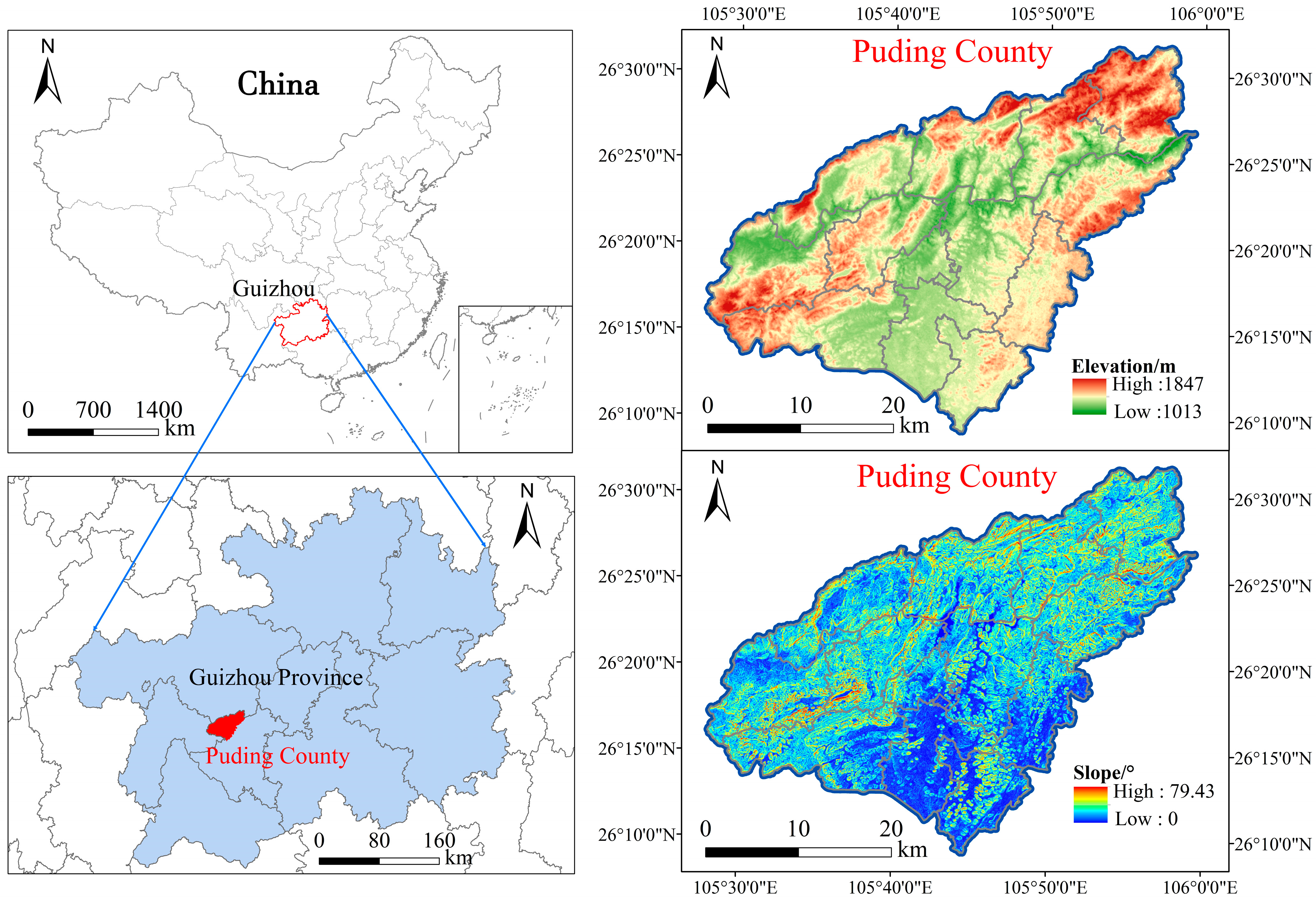
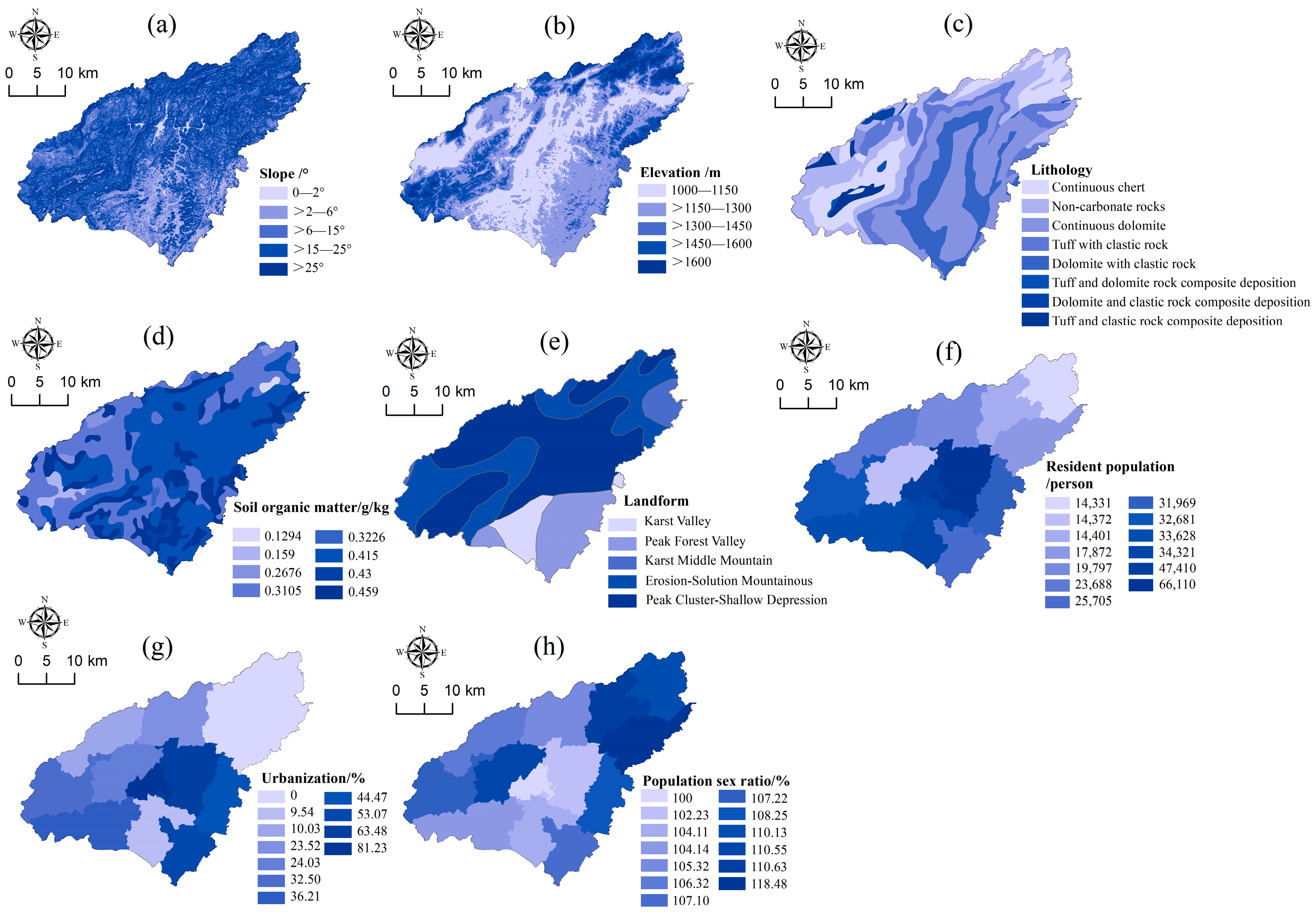
2.1. Study Area

Puting County (26°09′36″ N~26°31′42″ N, 105°27′49″ E~105°58′51″ E) is located in the central region of Guizhou (Figure 1), with an area of about 1090.49 km2, and the region is dominated by mountainous hills [23]. It is a typical karst landform growth area in southwest China, where carbonate rocks account for 79.2% of the study area, with an exposed area of 863.7 km2 [22] and a vulnerable ecological environment. The county is a key county in the construction project of the comprehensive management protection system for the Yangtze River and Pearl River basin. In recent years, implementing environmental projects such as returning farmland to forest and grass and migrating ecological relocation has caused the gradual abandonment of sloping arable land at high altitudes, and the center of gravity of human activities and construction land has moved to lower altitudes. Slope-cultivated land is mainly distributed on slopes from 2° to 20°, and soil erosion is serious due to the dual pressure of a vulnerable ecological environment and high-intensity planting conditions. Several ecological restoration projects have been carried out in Puding County to improve the soil erosion resistance of sloping arable land. The most significant effect comes from bio-measures such as the government’s efforts to develop high-efficiency special agriculture in mountainous areas and achieve excellent results. Our field research found that the transformation of land use quantity and function within karst mountain AESs have happened differently. As a typical and special area in the karst mountain region of southwest China, the transformation of the AES in Puding County has a high level of universality, and the transformation changes can represent a wide area in the karst mountain area of southwest China.

2.2. Data Source and Processing

The land use data of the study area were obtained from ASTER images (15 m spatial resolution) and Système Probatoire d’Observation de la Terre images (2.5 m spatial resolution) in 2004, and Google Earth high-resolution remote sensing image data in 2015 and 2020 with a resolution of 0.54 m. We used ArcGIS 10.7 software based on remote sensing data for human–computer interaction interpretation. We refer to the Classification of Land Use Status (GB/T21010-2017) and classify the land use types in the study area into seven types: woodland, grassland, garden land, waters, slope cultivated land, construction land, and unutilized land, regarding the practical conditions of the study area and the purpose of the study. We verified the classification accuracy of the classified images through field research and evaluated the classification accuracy by the Kappa indices of each year, which showed that the overall accuracy of vector data exceeded 90%. The Advanced Land Observing Satellite-1 provides ALOS-12m DEM data (12.5 m). After we obtained the classification maps of landscape components in different periods, we calculated and generated thematic maps for analysis in ArcGIS 10.7 software. The study area’s socio-economic and population data were obtained from the China County Statistical Yearbook (Township Volume) and the Anshun Statistical Yearbook.

2.3. Research Methods

2.3.1. Selection of Typical Landscape and Determination of Transformation

AESs are coupled by social and ecological systems [24] and linked to socio-economic and ecological environments mainly through the agricultural landscape and land use. Their internal changes can reflect the specific changes in socio-economic and ecological systems. We select typical landscapes for studying the transformation of AESs in karst mountain areas based on the actual landscape conditions in the study area and determine the dominant functional types of the landscape based on the subjective land use intentions of the actors [25]. SCL is closely related to socio-economic and food security [26] and can represent production land; CL is the main place for human production and life and means living land, so SCL and CL are chosen to represent “people”, i.e., as social subsystems. WGL is of relatively high ecological value and is closely linked to the regional environment, classifying them as ecological land. The economic and ecological benefits of the EFF are integrated, and it is classified as an ecological and economic land. WGL and EFF play an important role in the ecological safety and health of the region; therefore, they represent “land,” i.e., as an ecological subsystem. The transformation of AES results from human–land interaction, and the changes in typical landscapes can be used as a basis for the transformation of AES components and functions.

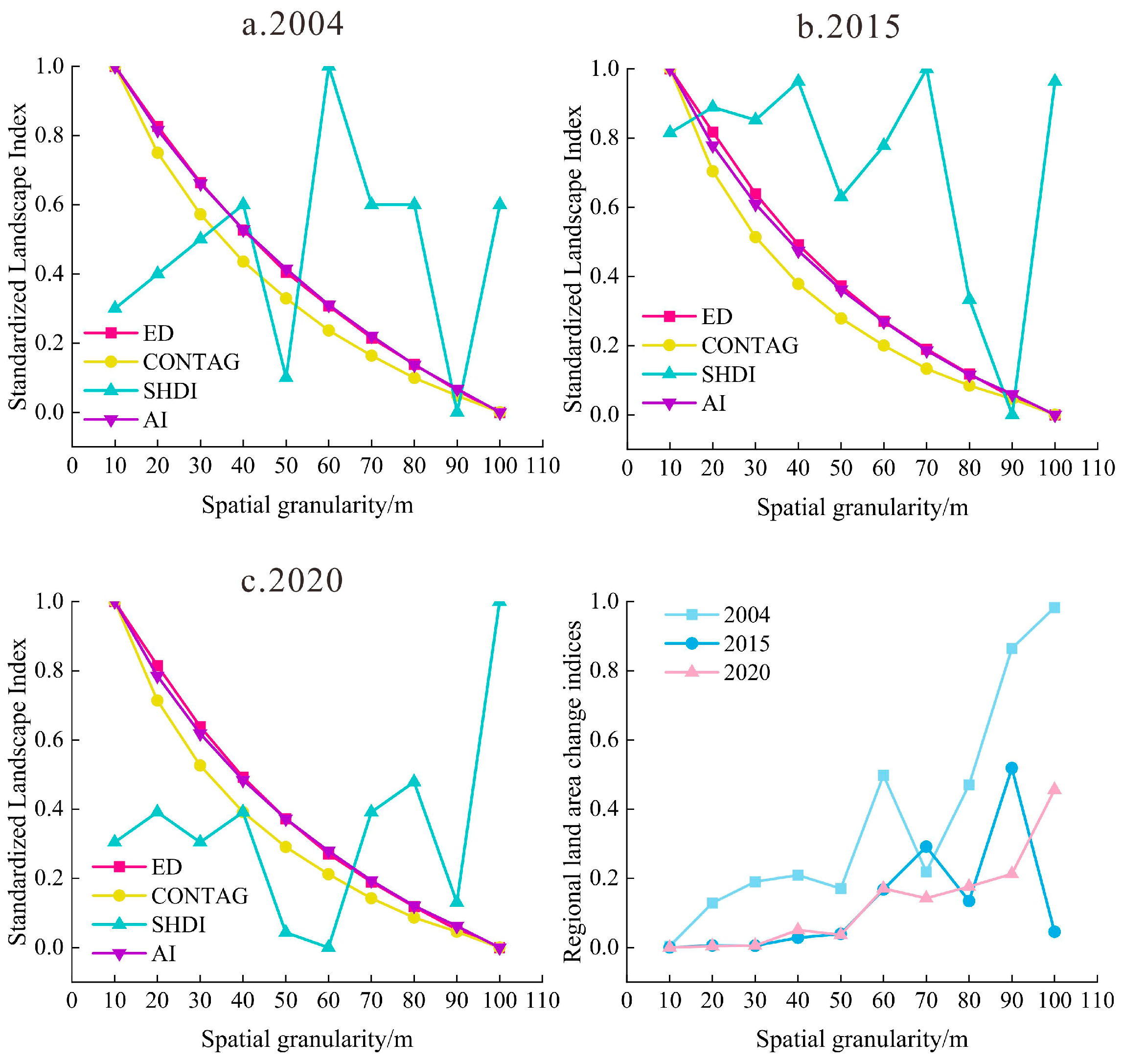
2.3.2. Landscape Index Selection

The landscape pattern index can effectively reflect the landscape pattern characteristics of AES and is an indicator for quantitative analysis of landscape structural composition and spatial configuration. To fully reflect the landscape pattern characteristics of AESs and to avoid redundant analysis [27,28], we used the software Fragstats 4.2 and selected landscape percentage (PLAND), patch density (PD), edge density (ED), shape index (LSI) and agglomeration index (AI) at the class level for landscape characterization of typical patterns of change in the study area regarding previous relevant studies and the actual situation of the study area (Table 1).
Furthermore, we also selected the contagion index (CONTAG), aggregation index (AI*), Shannon’s diversity index (SHDI), and edge density (ED*) at the landscape level for studying the spatial and temporal distribution of the overall landscape pattern of AESs, and their ecological significance and related algorithms are detailed in Ref. [29]. The granularity size affects the extraction of effective information, and the amount of information varies with the granularity size [30]. We used the analysis of the spatial granularity effect of landscape pattern to select the suitable granularity for landscape pattern analysis in the study area and converted the interpreted three-phase land use type data into raster data, with 10 m as the starting point, 100 m as the endpoint, and 10 m as the distance between them to generate 30 raster maps with different granularity levels, and found that 20 m was the most suitable spatial granularity for analysis in the study area according to the results of the analysis of the spatial granularity effect of landscape pattern and area information conservation evaluation (Figure 2).
Based on 20 m granularity to calculate the optimal magnitude, to reduce the computational redundancy, we selected the 2020 landscape classification data close to the current AES change trend as an example and picked 100 m, 200 m, 300 m, 400 m, and 500 m moving window sizes to calculate the landscape index values under different moving windows. We randomly extracted each landscape index value from 21 sample points and analyzed the effect of magnitude change on landscape index values. From Figure 3, we can see that the moving window size of 200 can ensure the gradient characteristics and will not cause large fluctuations in the landscape index, and we can use the landscape index change characteristics to reflect the spatial pattern changes truly [31]. Therefore, we calculated the landscape index by 20 m granularity and 200 m amplitude.

2.3.3. Geodetector

We used the factor detection and interaction detection of Geodetector to detect the causes affecting the transformation patterns of AESs. The natural environment factors mainly include slope (X1), elevation (X2), lithology (X3), soil organic matter (X4), and landform (X5), while the socio-economic factors mainly include resident population (X6), urbanization rate (X7), and population sex ratio (X8) (Figure 4). The driving factors were discretized by ArcGIS 10.7 and then used as independent variables of the Geodetector. The calculation formula is as follows:
q = 1 1 N δ 2 i = 1 L N i δ i 2
where q denotes the spatial differentiation of an indicator, q ∈ [0, 1]; N is the total number of samples in the study area; δ 2 denotes the variance of the indicator; and i denotes the partition ( i = 1, 2, …, L). Larger values of q indicate stronger explanatory power for the attribute’s independent variable and vice versa. When q = 0, it indicates that a factor has no relationship with the study object; when q = 1, it indicates that a factor completely controls the spatial distribution of the study object [32].

3. Results

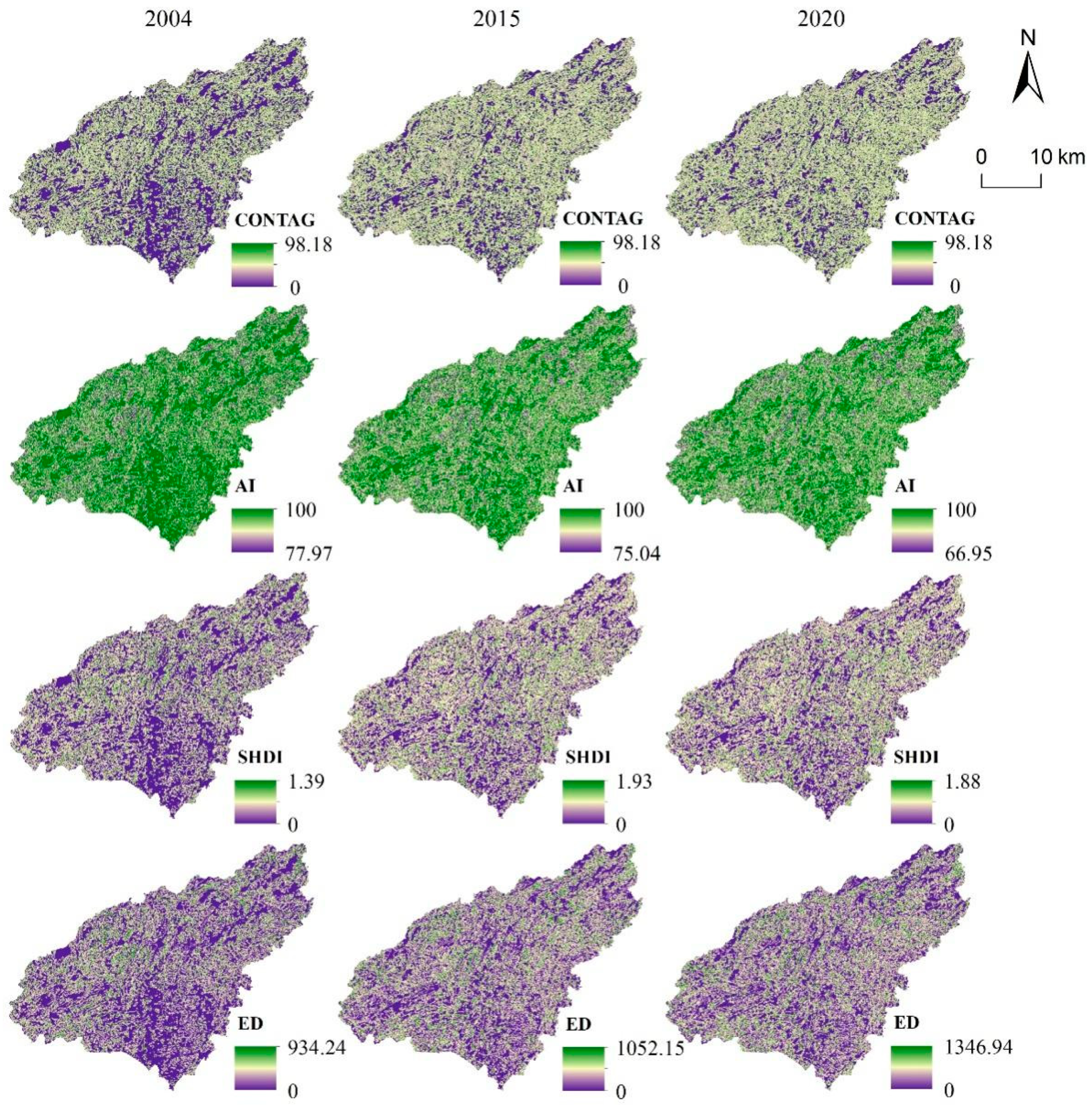
3.1. Spatial and Temporal Evolutionary Characteristics of the Overall Landscape Pattern of AES

The contagion and agglomeration indices can reflect the degree of landscape fragmentation, Shannon’s diversity index can reflect landscape diversity and complexity, and the edge density can reflect landscape stability [33,34]. From 2004 to 2020, CONTAG and AI in the study area decreased year by year, and SHDI and ED increased year by year (Table 2), showing that the AES landscape in the study area tended to diverse and complex, the dominant patches gradually decreased toward fragmentation, and the landscape agglomeration weakened. The diversified development of the landscape pattern was closely related to the abandonment of SCL and the expansion of EFF in the study area. Because of the spatial changes (Figure 5), the overall difference in contagion in the study area was slight, with the high-value areas mainly concentrated in the northwest in 2004 and gradually transferred to the areas with better development of EFF in the south in 2020. The agglomeration shows a small increasing trend in the low-value area spatially, and the agglomeration of the landscape is relatively weakened. Topography strongly influences AESs’ landscape diversity in the study area, with the development of diversified agricultural landscapes in gently sloping areas and the homogenization of landscapes on steep slopes at high altitudes. The landscape shows complexity, diversity, and stability development with an overall increase in patch density.

3.2. Spatial Pattern Characteristics of AES Subsystems

Figure 6 shows the spatial and temporal changes of PLAND values for each subsystem of the AES. WGL was more evenly distributed in the region in 2004, with a stronger concentration in the northwestern region with steeper slopes and higher elevations. In 2020, WGL showed an increasing trend in the region, further enhancing the landscape advantage. In 2004, the distribution of SCL was more evenly distributed in the region as a whole, and the dominant areas were mainly located in the southeastern part of the study area where the slope was flatter, and in 2020, the PLAND of SCL showed an obvious decreasing trend, and the SCL shrank and developed towards fragmentation. In 2004, the CL was relatively scattered, except for the central major urban area; other regions have a point-like disorderly distribution of CL. By 2020, the density of CL patches across the region will have increased, spreading outward with the major urban areas as the center. In 2004, the PLAND of EFF was weak, the patches were fragmented, and there were only a few EFF. By 2020, EFF increased significantly and spread to the whole area, mainly concentrated in the central part of the study area where the slope is gentle, the altitude is lower, and the patch area of EFFs increased remarkably.

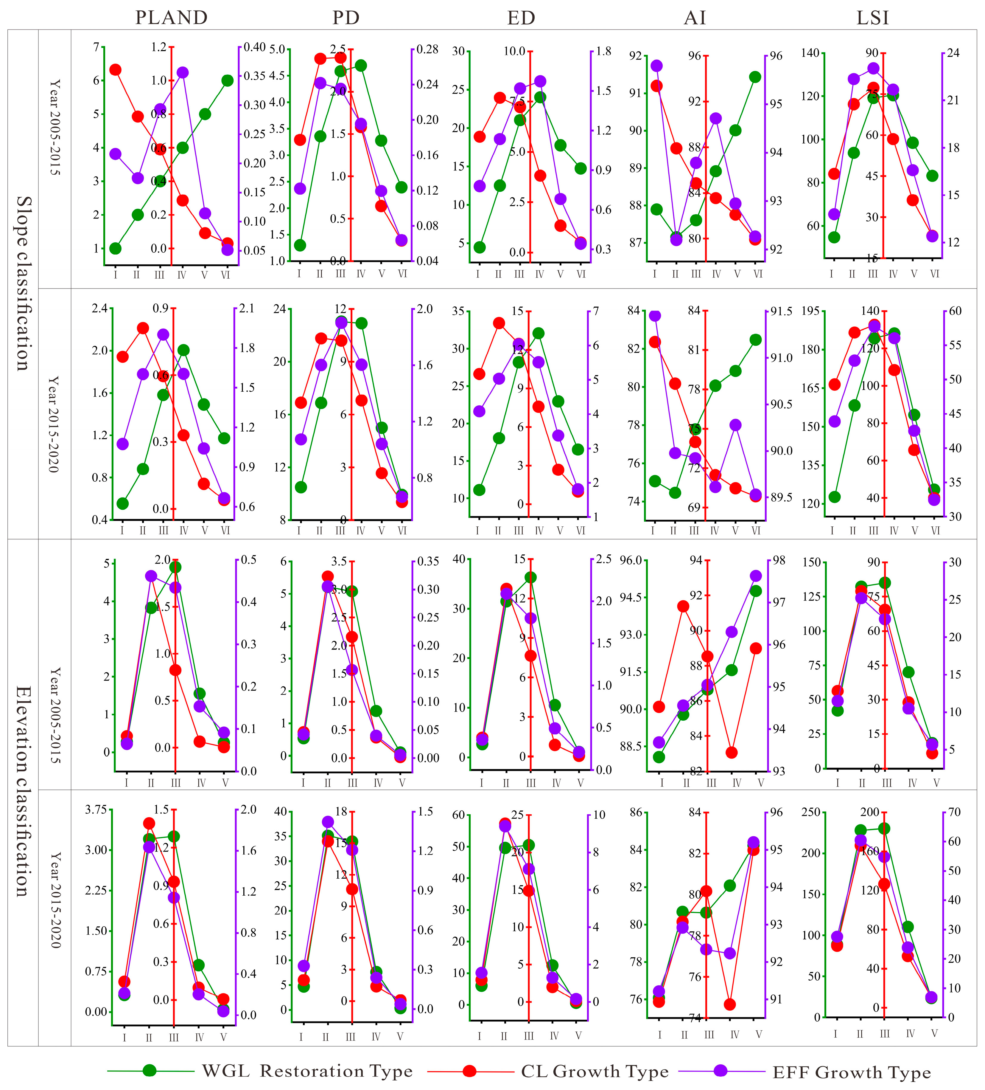
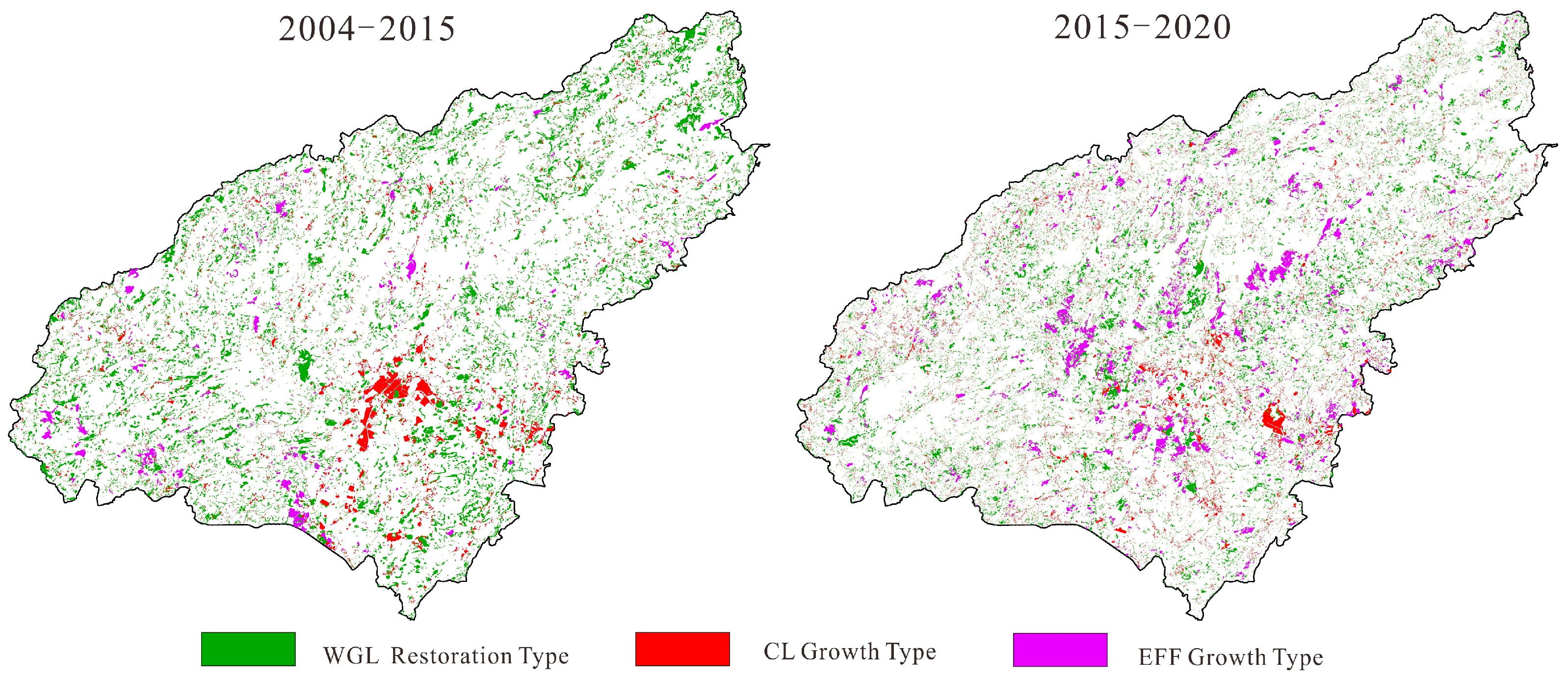
3.3. Landscape Pattern Analysis of Typical Patterns of AES Transformation

The AES transformation was classified into three models: WGL restoration type, CL growth type, and EFF growth type, according to the change characteristics of typical elements within the AES (Figure 7). The WGL restoration type PLAND increased with the increase in slope from 2004 to 2015, and the WGL restoration effect was significant in the steep-slope area, and PLAND showed a first increase and then decreased with the increase in slope from 2015 to 2020. From 2004 to 2020, PD, ED, and LSI showed a trend of increasing and then decreasing with the increase in slope. The peak of the new WGL was concentrated in the range of slope between 10° and 20°, with a high degree of landscape fragmentation and irregular shape, and the AI showed an overall increasing trend with the increase in slope. PLAND, PD, ED, and LSI showed a rising trend with the rise in elevation, and the WGL restoration type was concentrated in the range of elevation 1150–1450 m, and AI increased with the rise in elevation.
The CL growth type PLAND and AI of the landscape types in 2004–2015 and 2015–2020 decreased with the slope increase; the higher the slope, the less new CL and the lower the agglomeration. PD, ED, and LSI show a steady upward trend in the slope range between 0° and 10° and decrease with the increasing slope in the area above 15°. The index of each landscape pattern of the CL reaches its peak at the elevation of 1300 m, which indicates that the new CL is concentrated within this elevation.
The EFF growth type in 2004–2015 and 2015–2020 PLAND peaks are concentrated in the area with slopes between 0° and 20°. The AI value is highest in the slope less than 5° area, and this range mainly develops specialty industries such as leek, buddha gourd, edible mushroom, etc. The AI reaches another peak in the area with a slope between 15° and 20°, and this range concentrates on the development of EFF, such as walnut, plum, pokeweed, and tea. PLAND showed an increase and then decreased with the rise in elevation, the AI of new EFF increased with the increase in elevation from 2004 to 2015, and the AI was relatively stable in the range of elevation between 1150 m and 1600 m from 2015 to 2020, and PD, ED, and LSI showed an increase and then decrease with the increase in slope and elevation.
In summary, it can be seen that there are certain patterns within different AES transformation patterns, and the transformation of AESs in karst mountainous areas is gradually occurring through ecological and economical ways such as abandonment of SCL, expansion of the scale of EFF, concentrated and continuous development of CL, changes in planting structure, and development of land use toward intensification, and ecological and economic agricultural transformation is a new path applicable to the development of karst mountain areas. WGL, CL, and EFF grow mainly from SCL shrinkage. Thus, SCL shrinkage patterns are embedded in the above three transformation patterns. In addition to the above three typical patterns, other types of transformation patterns also exist in each pattern of the study area, and only three typical patterns are analyzed in this paper.

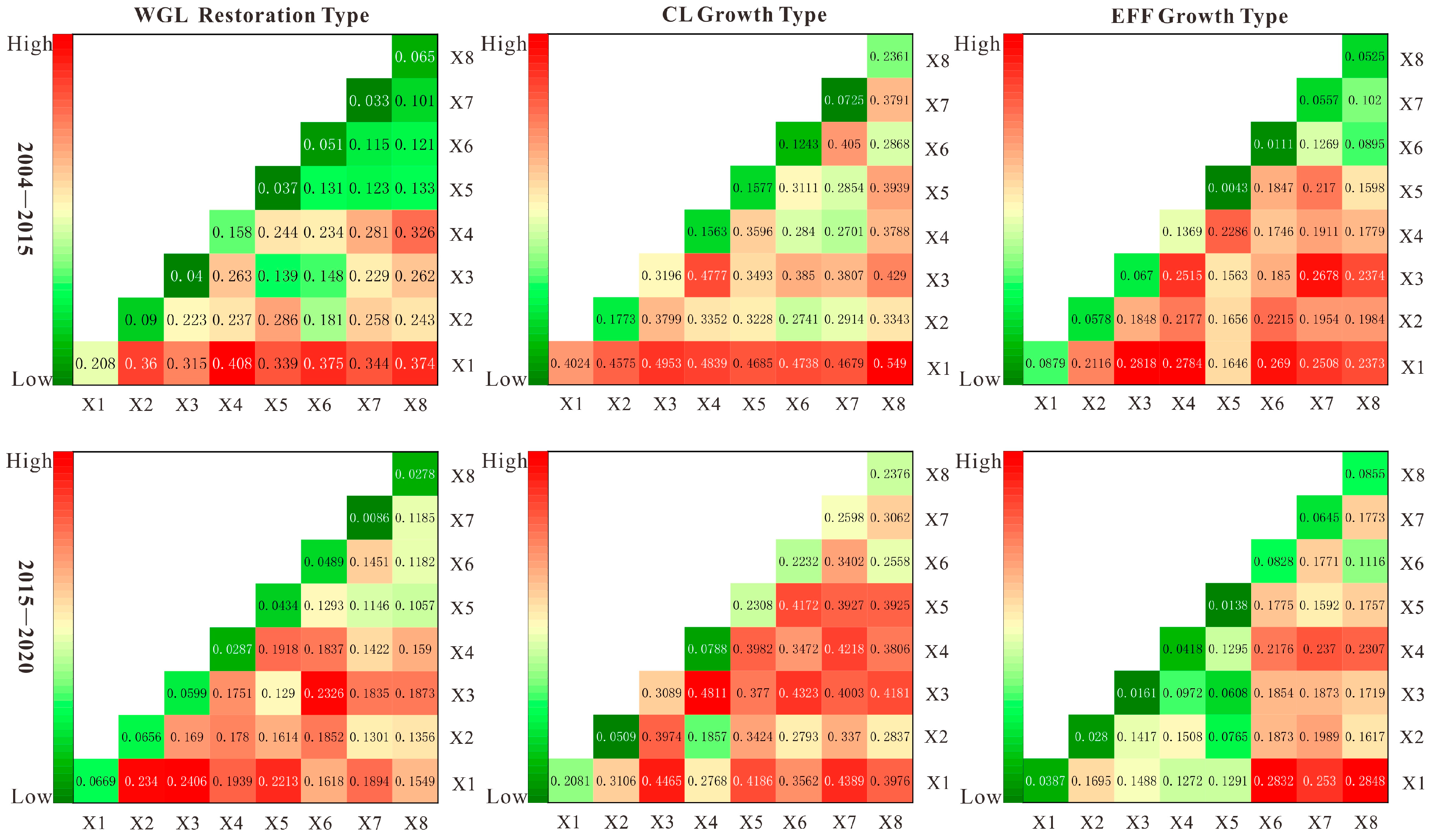
3.4. Analysis of the Drivers of AES Transformation Patterns

We used a combination of quantitative and qualitative approaches to explore the drivers of AES transformation in the karst mountain areas of southwestern China in natural, population, urbanization, and policy aspects. The factor analysis results using the Geodetector showed (Figure 8, p < 0.05) that the natural environment mainly influenced the WGL restoration type in AES transformation. The slope and elevation factors had the greatest influence on the restoration of WGL in the transformation process. The SCL with poor stand conditions moved to the gently sloping areas due to high input and low output, and a huge amount of SCL abandoned in the steep areas was transformed into WGL, and WGL was restored. The CL growth type is influenced by natural factors (slope) in the early transformation process, and socio-economic factors influence the growth of CL in the later transformation process. The urbanization rate is the main influencing factor for the growth of CL, rapid urbanization competition for land with agricultural land, and large-scale expansion of CL. Socio-economic influences dominate the evolution of the EFF growth type. The main influencing factors of EFF growth in the early stage include the soil organic matter, slope, and urbanization rate, and the resident population, urbanization rate, and population sex ratio mainly influence the later stage of growth.
Collectively, the transformation of ecological subsystems in AESs is mainly influenced more by natural environmental factors, and social subsystems, closely related to human beings, are influenced more by socio-economics. However, the transformation of the ecological subsystem mainly evolved from SCL, which, as the main part of the social subsystem, is influenced primarily by socio-economic development, so socio-economic factors dominate the main driving force of AES transformation in karst mountain areas.
AES transformation results from multiple factors, and the interaction of the driving factors of different AES transformation patterns is shown in Figure 9. The factor interactions are dominated by two-factor enhancement, and a few show non-linear enhancement, i.e., the intensity of different factor interactions is greater than the intensity of a single factor. Forest restoration type in 2004–2015 slope ∩ elevation (q = 0.3598), slope ∩ soil organic matter (0.4082), and slope ∩ resident population (0.375) have a greater influence on forested grassland growth, and any factor and slope interactions have high explanatory power. Slope ∩ elevation (0.234), slope ∩ landform (0.2213), and lithology ∩ resident population (0.2326) are the main factors that interact to influence the growth of WGL in 2015–2020, and the interaction of natural and socio-economic factors has a high explanatory power on the growth of WGL.
The CL growth type has high explanatory power for CL growth in 2005–2015 for slope ∩ population sex ratio (0.519), slope ∩ lithology (0.4953), slope ∩ soil organic matter (0.4839), slope ∩ resident population (0.4738), and slope ∩ urbanization rate (0.4679). The ecological migration policy in the karst mountain areas of southwest China caused CL in areas with poor surviving conditions to be abandoned. The government forced the new CL to migrate and expand to the gently livable areas through the unified expansion of resettlement houses, and the influence of slope on the expansion of CL in this period was large. The interaction with either factor had high explanatory power. The interaction factors with higher explanatory power for the CL growth type in 2015–2020 are slope ∩ urbanization rate (0.4389), lithology ∩ resident population (0.4323), and lithology ∩ soil organic matter (0.4811), and the CL is more significantly influenced by socio-economic factors in the later stage.
The EFF growth type had high explanatory power for EFF growth in 2005–2015 for slope ∩ lithology (0.2818), slope ∩ soil organic matter (0.2784), slope ∩ resident population (0.269), lithology ∩ urbanization rate (0.2678), and slope ∩ urbanization rate (0.2508). The interaction factors with high explanatory power in 2015–2020 were slope ∩ resident population (0.2832), slope ∩ population sex ratio (0.2818), slope ∩ urbanization rate (0.253), soil organic matter ∩ urbanization rate (0.237), resident population ∩ soil organic matter (0.2176), and population sex ratio ∩ soil organic matter (0.2307). Socio-economic factors more strongly influence the new EFF, and with the increasing professionalization and scale of the EFF industry in the study area, the relationship between the planting of EFF and the regional economy is becoming closer. Therefore, the transformation process of karst mountain AESs is not driven by a single factor but by a combination of natural and socio-economic factors [35].
AES transformation is a process that changes with the natural environment, socio-economics, and policies. Changes in regional agricultural policies have a guiding role in the direction of AES transformation [36] (Figure 10). In 2004, Guizhou Province vigorously carried out the policy of returning farmland to forest and grass to promote the abandonment of sloping farmland in high-altitude and steep-slope areas and accelerate the growth of WGL. The reform of forest land resources in Guizhou and the comprehensive management of rock desertification further promote structural changes within the AES, ecological environment restoration, and ecological function enhancement become the primary problems the government solves, the higher ecological pursuit of regional land use. In 2015, the construction of ecological civilization and ecological migration projects in Anshun City promoted regional ecological restoration and settlement changes, agricultural land far from settlements is gradually abandoned, and high-altitude and steep-slope areas have poor production conditions and are therefore further marginalized. Farmers have a significant impact on the transformation of AESs. In the pre-transformation period, farming conditions in the karst mountains were difficult, and farmers went to work in the urban areas in search of higher economic rewards, which resulted in serious rural emigration and caused regional agricultural land to be abandoned and transformed into WGL over time. The strategy of strengthening the province by industry has led to competition for land between towns and agricultural land, and a large amount of SCL has been transformed into CL. Poverty alleviation and overall well-being drive structural changes in agriculture and transform farmers’ livelihoods towards diversification. In 2020, the beautiful mountain county strategy, agricultural structure adjustment, and the modernization of mountain agriculture in Puding County drove the transformation of agriculture to modern economic and ecological agriculture. The government’s support for the development of EFF makes the development of EFF continuous and concentrated, the intensive scale is obvious, and modern agriculture is concentrated in the low and medium mountain expansion. The direction of agricultural land change and marginalization’s spatial and temporal characteristics can provide evidence for the study of AES transformation. Overall, AES transformation is transitioning from the SCL-dominated agricultural production-based landscape to ecologically dominated and eco-economic landscapes, driven primarily by socio-economics.

4. Discussion

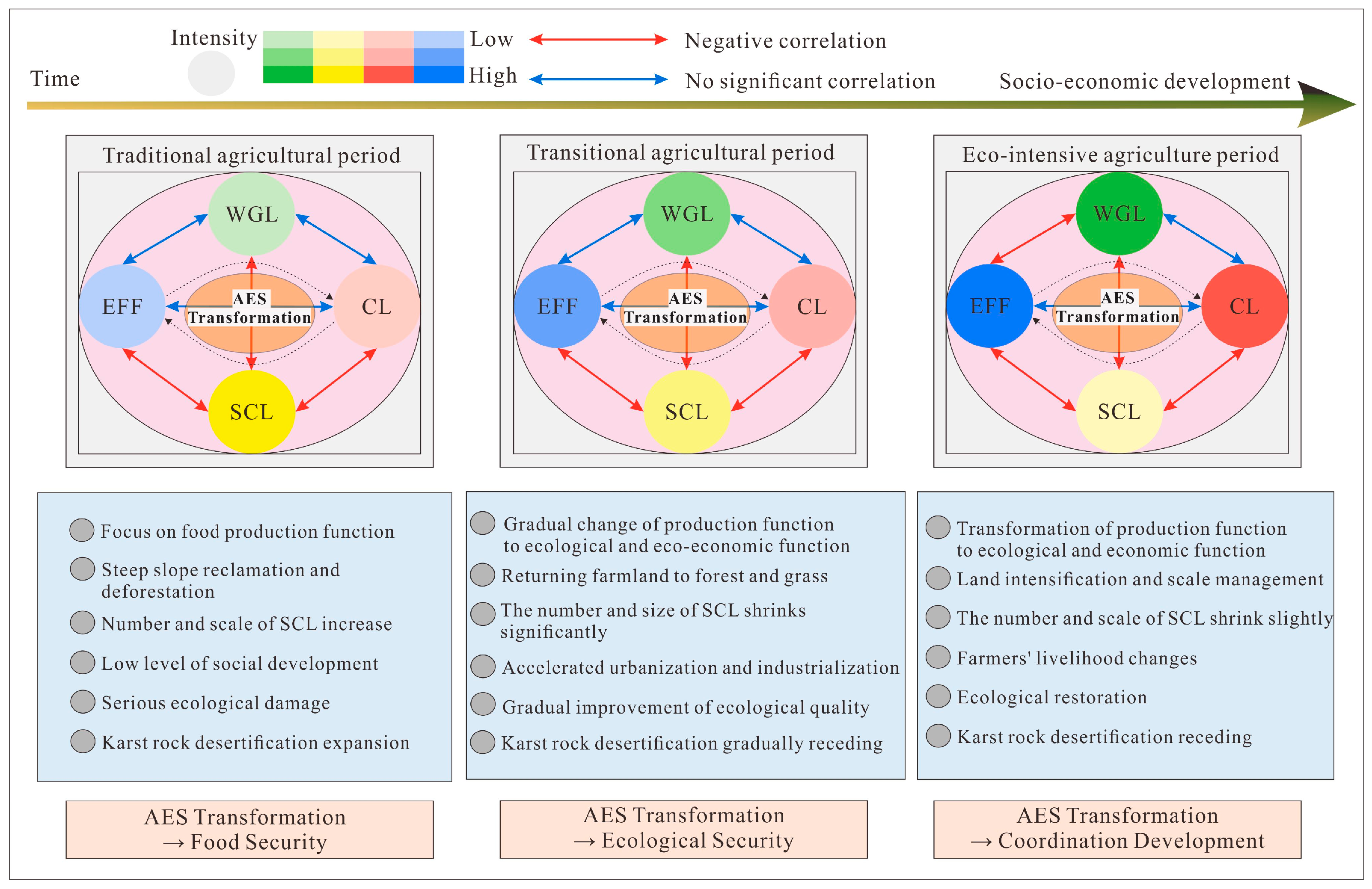
4.1. Summary of Transformation Trends and Changes in Dominant Functions of AESs in Karst Mountains

The rugged topography and fragmented landscape in the karst mountain areas of southwest China are the fundamental reasons for their relatively poor socio-economic development, and the remarkable verticality of their topography makes the verticality of the regional AES transformation process obvious. The AES transition patterns and their dominant functions change, as shown in Figure 11 and Figure 12; with increasing topographic gradients, different transition patterns dominate the AES transition. The transformation of AES in river valleys and hilly areas is mainly toward ecological and economic function-oriented development, and this is mainly due to the transformation of farmers’ livelihoods and the agricultural adjustment promoting a significant increase in the ecological and economic land use in the EFF in the southwestern karst mountainous areas. The concentration of settlements and modern ecological and economic agriculture in the low-altitude and gentle slope areas indicates the concentration of human activities in karst mountain areas to the gentle slope areas and the intensification of land use in areas with better production conditions to enhance the ecological recovery within the mountainous AESs, so that the region as a whole can obtain an economic and ecological win-win effect. With the increase in the topographic gradient, the ecological function orientation of the transformation of AESs in the middle and high mountain regions becomes increasingly apparent, and their production function gradually decreases. In addition, the landscape pattern changes of AES transformation patterns on different topographic gradients also reveal the dynamic change process of karst mountain AES. With the socio-economic development, human activities in the AES transformation process gradually gather in the low-elevation and gentle slope area, and the living and ecological–economic functions of the AESs in this area are enhanced. The social and ecological aspects within the AES are gradually segregated, with significant ecological aspects in the high-elevation region and significant social aspects in the low-elevation area, and the contraction situation is presented in the SCL of different topographic gradients.
The transformation of the internal structure of the AES in karst mountain areas is based on the transformation from traditional extensive farming to modern intensive agriculture, mainly through the ecological restoration of SCL abandonment, planting of EFF, and returning farmland to WGL, etc. The transformation of the primary production of food crops to economic and ecological crops on SCL. The center of gravity of human activity development in AESs is concentrated in low-altitude gentle slope areas with enhanced living functions, EFF agriculture is rapidly developing with enhanced ecological and economic functions, and farmers’ livelihoods are developing from traditional farming to modern ecological and economic complexes, and WGL is concentrated in high-altitude and steep-slope areas with enhanced ecological functions. The transformation of AESs in the karst mountain areas of southwest China has promoted ecological environment improvement, rock desertification retreats, and improved regional economic development. In other words, the AES internal subsystem functions show a harmonious development trend, and the human–land relationship develops toward harmony and win-win. This paper reveals the unique characteristics of the transformation trends and functional changes of AESs in karst mountainous areas of southwest China with a typical case study, which is a development based on previous studies and has guiding significance for the development of karst mountain areas.
Current global research also indicates that modernization of agriculture is the main trend in AES transformation, with increasing emphasis on the application of modern agricultural production methods and increasing concern for the environment [37], meaning that AES transformation is increasingly pursuing sustainable development of social systems and ecosystems. Sustainable land management and increased productivity are necessary prerequisites for the current AES transition, which tends to develop eco-economic landscapes [38]; for example, it has been confirmed in Ethiopia [39], Uganda [40], southern Europe [38], the Mediterranean [41], and New Zealand [42], among other countries. Our study further revealed trends in the transformation of AESs on different topographies on this basis.

4.2. Analysis of the Transformative Effect of Karst Mountain AESs

The transformation of AESs in karst mountainous areas is closely related to socio-economic and ecological environment and shows a dynamic evolution process with socio-economic development and time (Figure 13). Studies on the transformation of AESs in typical karst mountainous areas in southwest China show that the number and function of subsystems within AESs have changed significantly. During the traditional agricultural period in the southwestern karst mountains of China (1950–2000), to meet the growing population’s demand for food production, large-scale land clearing in the karst mountains area has caused tremendous damage to the ecological environment, and the scope of karst rock desertification has expanded, with agricultural cultivation being mainly extensive and the level of socio-economic development being low. The rapid socio-economic development during the transitional agricultural period (2000–2010), the ecological security of karst mountain areas became the primary goal of regional solving, and the large-scale implementation of the policy of returning farmland to forests and grasses caused a significant overall shrinkage of the traditional food crop agricultural landscape (SCL). The degree of SCL abandonment is significant, especially in the area with slopes above 20° and altitudes above 1450 m. It transforms into ecological lands such as WGL with the development of time and the conversion of SCL and WGL to each other, and the competition is fierce. The system’s transformation within the karst mountain area is mainly ecological restoration, and the production function within the AES changes to an ecological function. In addition, in the gentle slopes and low-altitude areas, SCL is transformed into intensive and continuous SCL driven by economic interests, and the production function gradually begins to change to ecological and economic functions. The ecological and eco-economic benefits of AESs were significantly enhanced during the transformation process in this period, providing a basis for the overall environmental greening in the karst mountainous areas of southwest China, in line with the findings of the scholars [43]. During eco-intensive agriculture (2010–present), the main concern was the pursuit of coordinated development of the social economy and the ecological environment. The internal functions of AESs have mainly changed from production to ecological and economic functions. The SCL has been transformed into a large area of WGL and EFF, and the EFF has also replaced part of the WGL for expansion, which has greatly improved the ecological environment of the karst mountains. The positive effects of SCL shrinkage and the growth of WGL and EFF on the ecological environment of karst mountain areas are consistent with the findings of other scholars’ studies on the ecological effects of land use transition [44]. In general, the transformation process of AESs in karst mountainous areas has developed in line with the improvement of the socio-economic level of mountainous areas, the livelihoods of farmers have diversified, human activities have concentrated in the middle- and low- altitude areas, the quality of the ecological environment in high-altitude and steep-slope areas has improved significantly, the ecology has recovered, the karst rock desertification has gradually retreated [45], and the overall ecological environment and socio-economy of karst mountainous areas have tended to develop in a coordinated way.

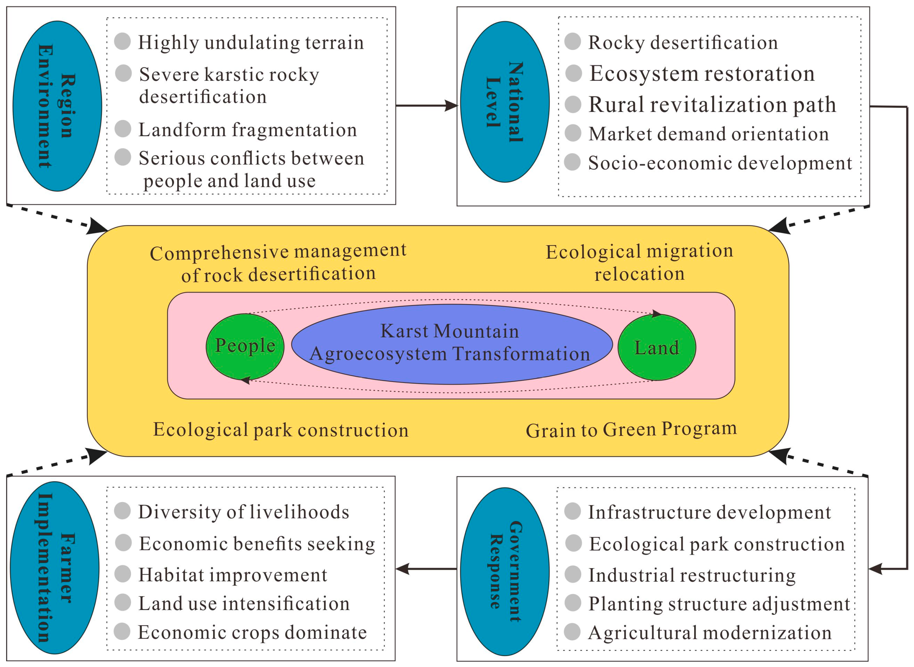
4.3. Agricultural Policy Suggestions for the Transformation of Future Karst Mountain AESs

The sustainable development of AESs has always been a hot concern for the government and academia. As a highly representative ecologically vulnerable area in the world, the karst mountain areas of southwest China have gradually recovered from rock desertification and ecological damage with socio-economic development in the region. Although the Chinese government has carried out a series of ecological restoration policies to improve the environment in recent decades, there are still some problems in the balance of agricultural management and land use. Based on this, to enhance the ecological and economic sustainability of the future AES transformation process, we offer some guiding measures for the future development of AES, and we believe that government policymakers could consider the following recommendations: (1) WGL and SCL are the main components of the AES in the study area, and the distribution of WGL and SCL has topographic gradient characteristics. Therefore, the subsequent development can be based on “ecological conservation in high mountains, ecological restoration in middle mountains, and agricultural development in low mountains”, WGL and agricultural land can be controlled and zoned. (2) Agriculture is the dominant industry in the economic development of the study area. Farmers are still mainly engaged in traditional farming and self-employment, the landscape of agricultural land is more fragmented, and the ecosystem is less restorative. Future agricultural development should consider improving agricultural planting technology and intensive management to reduce the intensity of agricultural land landscape utilization. For example, the multi-core industrial form of farmers and companies and cooperatives should be adopted in the organizational form, greenhouse planting should be carried out on a large scale in areas with better productivity, and high-tech agricultural planting technology should be introduced. (3) Follow the principle of adapting to local conditions, establish differentiated land use policies, and adjust ecological restoration measures according to the characteristics of AES in different areas. For example, reasonable planning of the growth boundary of CL, keeping the red line of cultivated land and ensuring the stable development of the AES structure in karst mountainous areas. (4) Policy-making departments should continue to increase the efforts of returning farmland to forest, rock desertification treatment and restoration in areas with slopes above 25°, consolidate the results of returning farmland to the forest in karst mountainous areas, and at the same time, to ensure that farmers’ benefits are not damaged, also implement the compensation system for farmers to return farmland to forest. (5) To improve farmers’ knowledge and realize the change in farmers’ planting consciousness, and to continue to promote the transfer of SCL in low mountain areas to ecological and economic win-win EFF in the future AES transformation process, as well as to strengthen farmers’ awareness of land conservation through environmental regulations to reduce the damage to ecosystems in the agricultural production process [46]. These measures need to coordinate with each other at the national and regional levels to jointly promote the socio-economic and ecological balance in karst mountain areas, improve the status of regional rock desertification, and enable the steady development of AES. Promoting AESs’ social and ecological balance in future research is an academic issue worthy of in-depth exploration.

4.4. Limitations and Prospects

This paper researches the characteristics of changing landscape patterns of karst mountain AESs and their driving mechanisms, which effectively reflect the transformation trajectory of AESs and contribute to the sustainable development of mountain AESs. However, our study has some limitations. First, the resolution of our remote sensing images is inconsistent, but we used high-resolution remote sensing images from the study period with small resolution gaps, which does not affect our findings. In addition, this paper classifies according to landscape uses and selects representative landscapes for study from both social and ecological perspectives. Therefore, our study does not classify abandoned land individually but includes abandoned land in WGL and unifies it as ecological land. Future research can further subdivide the land types and explore the deagriculturalization of agricultural land in depth from different perspectives. At the same time, a further distinction can be made between rural and urban areas, focusing the research on mountainous rural areas and strengthening the guidance of research results to rural areas.

5. Conclusions

Based on the people–land relationship and social-ecological system theory, we selected typical landscapes with “people” and “land” representations to explore the transformation trend of AESs in the karst mountain areas of southwest China, which is a new idea combined with the theory of forest transformation and rural land use transformation, and also a new concept based on the demand for the sustainability of social systems and ecosystems in the perspective of rural transformation. We selected Puding County, a typical representative of karst mountain areas, as the research object and, to some extent mapped the evolution of AESs in karst mountain areas in southwest China. By studying the transformation direction and characteristics of AESs in karst mountainous areas, summarizing typical patterns of AES transformation, and exploring the landscape patterns and their driving mechanisms of different patterns, we concluded the following:
(1)
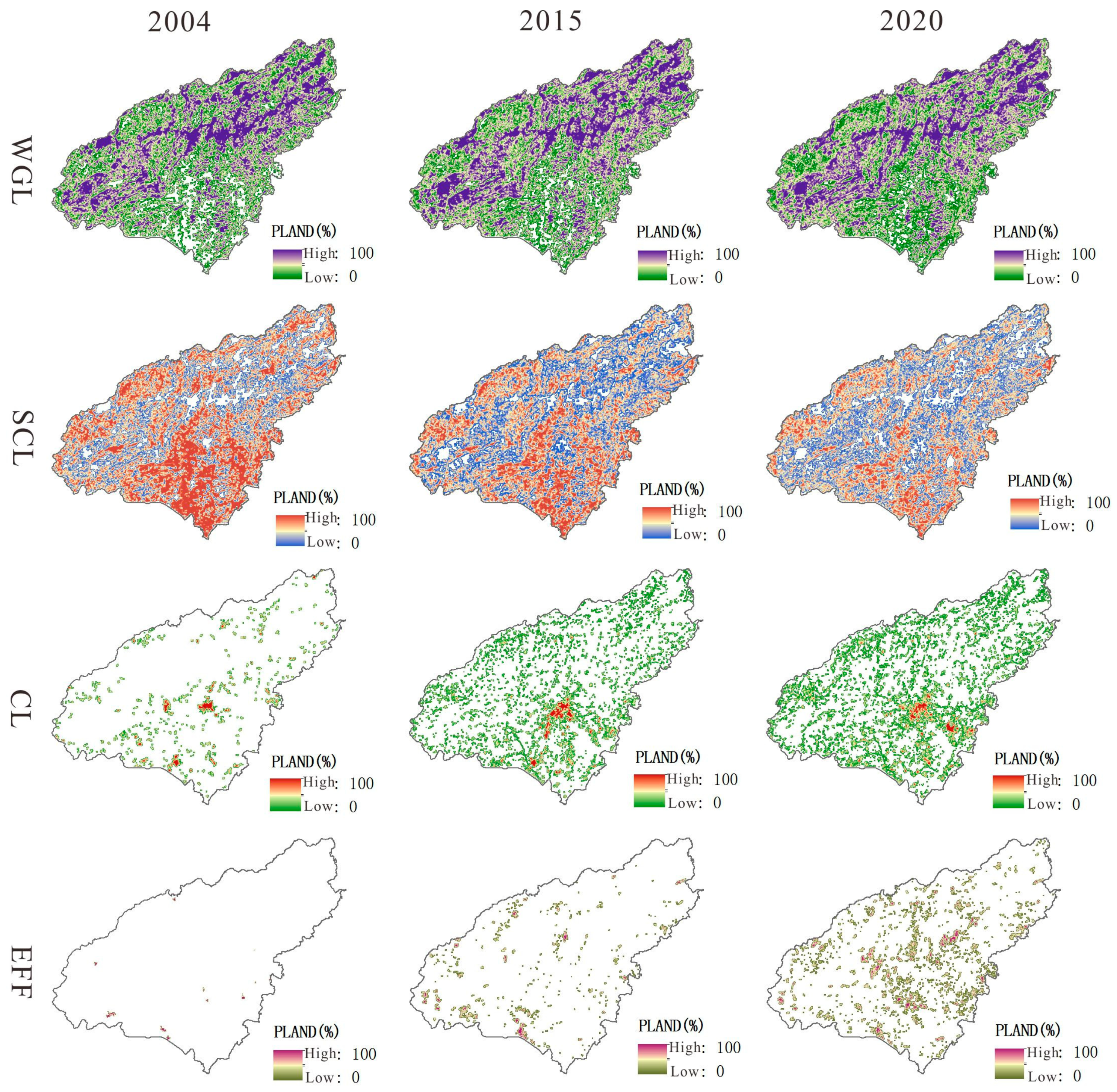
From 2004 to 2020, the overall landscape of AESs in the study area showed complex and diversified development, with smaller differences in CONTAG as a whole, decreasing AI in space year by year, stronger SHDI in gentle areas, and increasing ED year by year. In addition, the PLAND of each subsystem within the AES has changed significantly, with WGL showing an increasing trend in the whole area, the dominant area concentrated in the northwestern high-altitude and steep-slope area, the SCL showing a significant decreasing trend, the CL showing a trend of spreading outward with the main urban area as the center, and the EFF increasing significantly in the central part of the study area with lower altitude.
(2)
According to the main directions of the AES transformation, we summarized three typical transformation patterns of WGL restoration, CL growth, and EFF growth in this study. There are differences in the dominant transformation patterns on different topography. The WGL restoration mode is dominant in high-altitude areas, where the higher the altitude, the more aggregation of new WGL, the higher the fragmentation of patches, the irregular shape, and the enhanced ecological function. The low mountain areas are dominated by CL growth type, the new CL decreases with the increase in slope and elevation, and the aggregation is weakened, but its shape is regular, and the living function is enhanced. The EFF growth type dominates river valleys and hilly areas. The lower the slope and elevation, the higher the concentration of new EFF, the more concentrated and large-scale development, the more regular shape, and the significant enhancement of ecological and economic functions.
(3)
WGL restoration type is most influenced by slope and elevation in the transition process; CL growth type is most influenced by slope in the early period, and urbanization rate is the main influencing factor in the later transition process; EFF growth type is mainly influenced by soil organic matter, slope, and urbanization rate in the early transition period, and mainly influenced by population and urbanization rate in the later transition process. In general, socio-economic factors are the main driving force of AES transformation.

Author Contributions

Conceptualization and methodology, Y.L.; project administration, Y.L.; resources, Y.L.; supervision, Y.L.; drafting, L.Y. (Limin Yu); data processing, L.Y. (Limin Yu), M.Y., M.C. and L.Y. (Linyu Yang); writing, L.Y. (Limin Yu); review and editing, L.Y. (Limin Yu), M.Y., M.C. and L.Y. (Linyu Yang); language modification and check, L.Y. (Limin Yu), Y.L., M.Y., M.C. and L.Y. (Linyu Yang). All authors discussed the results and contributed to the final manuscript. All authors have read and agreed to the published version of the manuscript.

Funding

This work was supported by the National Natural Science Foundation of China (Grant number: 42061035) and funding from Guizhou Normal University (Grant Number: [2021]A22).

Institutional Review Board Statement

Not applicable.

Informed Consent Statement

Not applicable.

Data Availability Statement

The data presented in this study are available on request from the corresponding author. The data are not publicly available due to privacy.

Conflicts of Interest

The authors declare no conflict of interest.

References

  1. Bethwell, C.; Burkhard, B.; Daedlow, K.; Sattler, C.; Reckling, M.; Zander, P. Towards an Enhanced Indication of Provisioning Ecosystemservices in Agro-Ecosystems. Environ. Monit. Assess. 2021, 193, 269. [Google Scholar] [CrossRef]
  2. Nadal-Romero, E.; Cammeraat, E.; Pérez-Cardiel, E.; Lasanta, T. Effects of Secondary Succession and Afforestation Practices on Soil Properties after Cropland Abandonment in Humid Mediterranean Mountain Areas. Agric. Ecosyst. Environ. 2016, 228, 91–100. [Google Scholar] [CrossRef] [Green Version]
  3. Kamada, M.; Nakagoshi, N. Influence of Cultural Factors on Landscapes of Mountainous Farm Villages in Western Japan. Landsc. Urban Plan. 1997, 37, 85–90. [Google Scholar] [CrossRef]
  4. Kassa, H.; Dondeyne, S.; Poesen, J.; Frankl, A.; Nyssen, J. Transition from Forest-Based to Cereal-Based Agricultural Systems: A Review of the Drivers of Land Use Change and Degradation in Southwest Ethiopia. Land Degrad. Dev. 2017, 28, 431–449. [Google Scholar] [CrossRef] [Green Version]
  5. Liang, X.; Li, Y.; Shao, J.; Ran, C. Traditional Agroecosystem Transition in Mountainous Area of Three Gorges Reservoir Area. J. Geogr. Sci. 2020, 30, 281–296. [Google Scholar] [CrossRef]
  6. Nair, V.D.; Nair, P.K.R.; Dari, B.; Freitas, A.M.; Chatterjee, N.; Pinheiro, F.M. Biochar in the Agroecosystem–Climate-Change–Sustainability Nexus. Front. Plant Sci. 2017, 8, 2051. [Google Scholar] [CrossRef]
  7. Liang, X.; Li, Y.; Ran, C.; Li, M.; Zhang, H. Study on the Transformed Farmland Landscape in Rural Areas of Southwest China: A Case Study of Chongqing. J. Rural Stud. 2020, 76, 272–285. [Google Scholar] [CrossRef]
  8. Long, H.; Li, Y.; Liu, Y.; Woods, M.; Zou, J. Accelerated Restructuring in Rural China Fueled by ‘Increasing vs. Decreasing Balance’ Land-Use Policy for Dealing with Hollowed Villages. Land Use Policy 2012, 29, 11–22. [Google Scholar] [CrossRef]
  9. Tan, M.; Li, X. The Changing Settlements in Rural Areas under Urban Pressure in China: Patterns, Driving Forces and Policy Implications. Landsc. Urban Plan. 2013, 120, 170–177. [Google Scholar] [CrossRef]
  10. Lu, Q.; Liang, F.; Bi, X.; Duffy, R.; Zhao, Z. Effects of Urbanization and Industrialization on Agricultural Land Use in Shandong Peninsula of China. Ecol. Indic. 2011, 11, 1710–1714. [Google Scholar] [CrossRef]
  11. Wenhua, L. Degradation and Restoration of Forest Ecosystems in China. For. Ecol. Manag. 2004, 201, 33–41. [Google Scholar] [CrossRef]
  12. Zhao, G.; Mu, X.; Wen, Z.; Wang, F.; Gao, P. Soil Erosion, Conservation, and Eco-Environment Changes in the Loess Plateau of China. Land Degrad. Dev. 2013, 24, 499–510. [Google Scholar] [CrossRef]
  13. Viglizzo, E.F.; Roberto, Z.E.; Filippin, M.C.; Pordomingo, A.J. Climate Variability and Agroecological Change in the Central Pampas of Argentina. Agric. Ecosyst. Environ. 1995, 55, 7–16. [Google Scholar] [CrossRef]
  14. Araral, E. What Makes Socio-Ecological Systems Robust? An Institutional Analysis of the 2000 Year-Old Ifugao Society. Hum. Ecol. 2013, 41, 859–870. [Google Scholar] [CrossRef]
  15. Enfors, E. Social–Ecological Traps and Transformations in Dryland Agro-Ecosystems: Using Water System Innovations to Change the Trajectory of Development. Glob. Environ. Chang. 2013, 23, 51–60. [Google Scholar] [CrossRef]
  16. Peng, J.; Tian, L.; Zhang, Z.; Zhao, Y.; Green, S.M.; Quine, T.A.; Liu, H.; Meersmans, J. Distinguishing the Impacts of Land Use and Climate Change on Ecosystem Services in a Karst Landscape in China. Ecosyst. Serv. 2020, 46, 101199. [Google Scholar] [CrossRef]
  17. Tong, X.; Brandt, M.; Yue, Y.; Horion, S.; Wang, K.; Keersmaecker, W.D.; Tian, F.; Schurgers, G.; Xiao, X.; Luo, Y.; et al. Increased Vegetation Growth and Carbon Stock in China Karst via Ecological Engineering. Nat. Sustain. 2018, 1, 44–50. [Google Scholar] [CrossRef]
  18. Verburg, P.H.; Van De Steeg, J.; Veldkamp, A.; Willemen, L. From Land Cover Change to Land Function Dynamics: A Major Challenge to Improve Land Characterization. J. Environ. Manag. 2009, 90, 1327–1335. [Google Scholar] [CrossRef]
  19. Li, S.; Zhao, X.; Pu, J.; Miao, P.; Wang, Q.; Tan, K. Optimize and Control Territorial Spatial Functional Areas to Improve the Ecological Stability and Total Environment in Karst Areas of Southwest China. Land Use Policy 2021, 100, 104940. [Google Scholar] [CrossRef]
  20. Guo, B.; Zang, W.; Luo, W. Spatial-Temporal Shifts of Ecological Vulnerability of Karst Mountain Ecosystem-Impacts of Global Change and Anthropogenic Interference. Sci. Total Environ. 2020, 741, 140256. [Google Scholar] [CrossRef] [PubMed]
  21. Cai, H.; Yang, X.; Wang, K.; Xiao, L. Is Forest Restoration in the Southwest China Karst Promoted Mainly by Climate Change or Human-Induced Factors? Remote Sens. 2014, 6, 9895–9910. [Google Scholar] [CrossRef] [Green Version]
  22. Wang, J.; Zou, B.; Liu, Y.; Tang, Y.; Zhang, X.; Yang, P. Erosion-Creep-Collapse Mechanism of Underground Soil Loss for the Karst Rocky Desertification in Chenqi Village, Puding County, Guizhou, China. Environ. Earth Sci. 2014, 72, 2751–2764. [Google Scholar] [CrossRef]
  23. Qin, L.; Bai, X.; Wang, S.; Zhou, D.; Luo, G.; Zhang, S.; Li, P.; Li, Y. Landscape Pattern Evolution of Typical Karst Plateau in Puding, Guizhou during Last 40 Years. Chin. J. Ecol. 2014, 33, 3349. [Google Scholar]
  24. Liu, Y.; Yang, C.; Tan, S.; Zhou, H.; Zeng, W. An Approach to Assess Spatio-Temporal Heterogeneity of Rural Ecosystem Health: A Case Study in Chongqing Mountainous Area, China. Ecol. Indic. 2022, 136, 108644. [Google Scholar] [CrossRef]
  25. Han, D.; Qiao, J.; Zhu, Q. Rural-Spatial Restructuring Promoted by Land-Use Transitions: A Case Study of Zhulin Town in Central China. Land 2021, 10, 234. [Google Scholar] [CrossRef]
  26. Wang, Q.; Li, Y.; Luo, G. Spatiotemporal Change Characteristics and Driving Mechanism of Slope Cultivated Land Transition in Karst Trough Valley Area of Guizhou Province, China. Environ. Earth Sci. 2020, 79, 284. [Google Scholar] [CrossRef]
  27. Fang, S.; Zhao, Y.; Han, L.; Ma, C. Analysis of Landscape Patterns of Arid Valleys in China, Based on Grain Size Effect. Sustainability 2017, 9, 2263. [Google Scholar] [CrossRef] [Green Version]
  28. Lustig, A.; Stouffer, D.B.; Roigé, M.; Worner, S.P. Towards More Predictable and Consistent Landscape Metrics across Spatial Scales. Ecol. Indic. 2015, 57, 11–21. [Google Scholar] [CrossRef]
  29. Naveh, Z.; Lieberman, A.S. Landscape Ecology: Theory and Application; Springer Science & Business Media: Berlin/Heidelberg, Germany, 2013. [Google Scholar]
  30. Zhang, N.; Li, H. Sensitivity and Effectiveness and of Landscape Metric Scalograms in Determining the Characteristic Scale of a Hierarchically Structured Landscape. Landsc. Ecol. 2013, 28, 343–363. [Google Scholar] [CrossRef]
  31. Whittaker, R.H. Vegetation of the Siskiyou Mountains, Oregon and California. Ecol. Monogr. 1960, 30, 279–338. [Google Scholar] [CrossRef]
  32. Zhu, L.; Meng, J.; Zhu, L. Applying Geodetector to Disentangle the Contributions of Natural and Anthropogenic Factors to NDVI Variations in the Middle Reaches of the Heihe River Basin. Ecol. Indic. 2020, 117, 106545. [Google Scholar] [CrossRef]
  33. Palmer, G.C. Principles and Methods in Landscape Ecology: Towards a Science of Landscape. Ecol. Soc. 2008, 33, 361–362. [Google Scholar] [CrossRef]
  34. Fu, F.; Deng, S.; Wu, D.; Liu, W.; Bai, Z. Research on the Spatiotemporal Evolution of Land Use Landscape Pattern in a County Area Based on CA-Markov Model. Sustain. Cities Soc. 2022, 80, 103760. [Google Scholar] [CrossRef]
  35. Ding, X.; Cai, Z.; Fu, Z. Does the New-Type Urbanization Construction Improve the Efficiency of Agricultural Green Water Utilization in the Yangtze River Economic Belt? Environ. Sci. Pollut. Res. 2021, 28, 64103–64112. [Google Scholar] [CrossRef]
  36. Guo, B.; Yang, F.; Fan, Y.; Zang, W. The Dominant Driving Factors of Rocky Desertification and Their Variations in Typical Mountainous Karst Areas of Southwest China in the Context of Global Change. CATENA 2023, 220, 106674. [Google Scholar] [CrossRef]
  37. Kozar, R.; Djalante, R.; Leimona, B.; Subramanian, S.M.; Saito, O. The Politics of Adaptiveness in Agroecosystems and Its Role in Transformations to Sustainable Food Systems. Earth Syst. Gov. 2023, 15, 100164. [Google Scholar] [CrossRef]
  38. Salvia, R.; Egidi, G.; Vinci, S.; Salvati, L. Desertification Risk and Rural Development in Southern Europe: Permanent Assessment and Implications for Sustainable Land Management and Mitigation Policies. Land 2019, 8, 191. [Google Scholar] [CrossRef] [Green Version]
  39. Gebrelibanos, T.; Assen, M. Land Use/Land Cover Dynamics and Their Driving Forces in the Hirmi Watershed and Its Adjacent Agro-Ecosystem, Highlands of Northern Ethiopia. J. Land Use Sci. 2015, 10, 81–94. [Google Scholar] [CrossRef]
  40. Banadda, N. Gaps, Barriers and Bottlenecks to Sustainable Land Management (SLM) Adoption in Uganda. Afr. J. Agric. Res. 2010, 5, 3571–3580. [Google Scholar]
  41. Marchi, M.; Ferrara, C.; Biasi, R.; Salvia, R.; Salvati, L. Agro-Forest Management and Soil Degradation in Mediterranean Environments: Towards a Strategy for Sustainable Land Use in Vineyard and Olive Cropland. Sustainability 2018, 10, 2565. [Google Scholar] [CrossRef] [Green Version]
  42. Moller, H.; MacLeod, C.J.; Haggerty, J.; Rosin, C.; Blackwell, G.; Perley, C.; Meadows, S.; Weller, F.; Gradwohl, M. Intensification of New Zealand Agriculture: Implications for Biodiversity. N. Z. J. Agric. Res. 2008, 51, 253–263. [Google Scholar] [CrossRef] [Green Version]
  43. Macias-Fauria, M. Satellite Images Show China Going Green; Springer: Berlin/Heidelberg, Germany, 2018. [Google Scholar]
  44. Wang, M.; Qin, K.; Jia, Y.; Yuan, X.; Yang, S. Land Use Transition and Eco-Environmental Effects in Karst Mountain Area Based on Production-Living-Ecological Space: A Case Study of Longlin Multinational Autonomous County, Southwest China. Int. J. Environ. Res. Public Health 2022, 19, 7587. [Google Scholar] [CrossRef]
  45. Xiong, L.; Bai, X.; Zhao, C.; Li, Y.; Tan, Q.; Luo, G.; Wu, L.; Chen, F.; Li, C.; Ran, C.; et al. High-Resolution Data Sets for Global Carbonate and Silicate Rock Weathering Carbon Sinks and Their Change Trends. Earth’s Future 2022, 10, e2022EF002746. [Google Scholar] [CrossRef]
  46. Ding, X.; Chen, Y.; Li, M.; Liu, N. Booster or Killer? Research on Undertaking Transferred Industries and Residents’ Well-Being Improvements. Int. J. Environ. Res. Public Health 2022, 19, 15422. [Google Scholar] [CrossRef] [PubMed]
Figure 1. Location of the study area (drawing review No. GS (2019) 1822).
Sustainability 15 09160 g001
Figure 2. Change in landscape indices with the different spatial granularity from 2004 to 2020 ((a) 2004, (b) 2015, (c) 2020).
Sustainability 15 09160 g002
Figure 3. Variation curves of landscape index along sample points at different spatial magnitudes.
Sustainability 15 09160 g003
Figure 4. Spatial distribution of agroecosystem transformation drivers in the study area in 2020: (a) slope (X1); (b) elevation (X2); (c) lithology (X3); (d) soil organic matter (X4); (e) landform (X5); (f) resident population (X6); (g) urbanization rate (X7); (h) population sex ratio (X8).
Sustainability 15 09160 g004
Figure 5. Spatial and temporal distribution of the overall landscape pattern in the study area.
Sustainability 15 09160 g005
Figure 6. Spatial and temporal distribution patterns of AES subsystems in the study area.
Sustainability 15 09160 g006
Figure 7. Landscape transformation pattern of AESs in the study area (Slope Ⅰ, Ⅱ, Ⅲ, Ⅳ, Ⅴ, Ⅵ indicates 0–5°, >5–10°, >10–15°, >15–20°, >20–25°, >25°; elevation Ⅰ, Ⅱ, Ⅲ, Ⅳ, Ⅴ corresponds to 1000–1150 m, >1150–1300 m, >1300–1450 m, >1450–1600 m, >1600 m).
Sustainability 15 09160 g007
Figure 8. Drivers of AES transformation in karst mountainous areas (X1: slope; X2: elevation; X3: lithology; X4: soil organic matter; X5: landform; X6: resident population; X7: urbanization rate; X8: population sex ratio).
Sustainability 15 09160 g008
Figure 9. Interaction results of AES transformation drivers (X1: slope; X2: elevation; X3: lithology; X4: soil organic matter; X5: landform; X6: resident population; X7: urbanization rate; X8: population sex ratio).
Sustainability 15 09160 g009
Figure 10. Mechanisms driving the transformation of AESs in Karst mountains.
Sustainability 15 09160 g010
Figure 11. Results of typical landscape transformation of AESs in the study area from 2004 to 2020.
Sustainability 15 09160 g011
Figure 12. Summary of transformation patterns of karst mountain AESs and their functional changes.
Sustainability 15 09160 g012
Figure 13. AES transformation effects.
Sustainability 15 09160 g013
Table 1. Illustrative table of landscape indices at the class level [29].
Landscape IndexMathematical ModelsMeaningEcological Significance
landscape percentage
(PLAND)
P L A N D = j = 1 n a i j A n is the number of patches of landscape type i , a j i is the area of the j th patch of landscape type i , and A is the total area of the landscape. The range of values:
0 ≤ P L A N D ≤ 100
Indicates the percentage of total landscape area accounted for by a particular landscape type and is one of the bases to help determine the dominant landscape element in the landscape.
patch density
(PD)
P D = N B N denotes the number of patches of a certain type in the landscape, B denotes the area of patches of a certain type, and the formula denotes the number of patches per square kilometer. Range of values:
P D > 0
Reflects the degree of spatial heterogeneity of the landscape, and the fragmentation of landscape patches within agroecosystems.
edge density
(ED)
E D = k = 1 m e i k A × 1000 e i k denotes the length of the boundary between the patches of landscape elements of category i and the patches of adjacent landscape elements of category j in the landscape; A denotes the total area of the landscape—unit: m/ha.Reflects the edge length between heterogeneous landscape elements patches per unit area within the landscape. The larger the value, the more heterogeneous landscape patches and the more fragmented the landscape.
shape index
(LSI)
L S I = 0.25 E A E is the total length of the boundaries of all patches in the landscape; A is the total area of the landscape. Range of values:
L S I ≥ 1
When there is only one square patch in the landscape, L S I = 1; when the plate shape in the landscape is irregular or deviates from the square, L S I increases.
agglomeration index
(AI)
A I = g i j max g i j × 100 g i j indicates the number of similar neighboring patches of the corresponding landscape patch type. Range of values:
0 < A I ≤ 100
The length of the common boundary between the image elements of the patches judges the degree of aggregation and dispersion of the patches. The smaller the length of the common boundary among the image elements, the smaller the degree of aggregation; the larger the common boundary, the greater the degree of patch aggregation.
Table 2. Changes in the overall landscape pattern index in the study area.
YearsCONTAG/%AI */%SHDIED *
200460.102789.81871.1532101.6691
201550.948284.90171.3268150.8765
202047.012884.71061.4529152.8342
Note: The asterisk * is used to distinguish the AI and ED at the class level and the landscape level in this paper, and with * indicates the AI and ED at the landscape level.
Disclaimer/Publisher’s Note: The statements, opinions and data contained in all publications are solely those of the individual author(s) and contributor(s) and not of MDPI and/or the editor(s). MDPI and/or the editor(s) disclaim responsibility for any injury to people or property resulting from any ideas, methods, instructions or products referred to in the content.

