Article

Linear Parks as Urban Commons—Considerations from Mexico City

by
Simone Buratti
1,* and
Leticia Merino-Pérez
2
1
Posgrado en Ciencias de la Sostenibilidad, Universidad Nacional Autónoma de México, Mexico City 04510, Mexico
2
Instituto de Investigaciones Sociales, Universidad Nacional Autónoma de México, Mexico City 04510, Mexico
*
Author to whom correspondence should be addressed.
Sustainability 2023, 15(12), 9542; https://doi.org/10.3390/su15129542
Submission received: 22 March 2023 / Revised: 30 May 2023 / Accepted: 8 June 2023 / Published: 14 June 2023
(This article belongs to the Special Issue Sustainable Urban Planning: In Search for Alternatives)

Abstract

:
This article aims to understand, from the conceptual proposal of urban commons, the social processes of use and appropriation of infrastructures developed in the framework of urban sustainability policies in cities of the Global South. Specifically, it is part of the debate on the type of interventions needed to promote non-motorized mobility, based on a case study developed in the Ferrocarril de Cuernavaca, the first linear park built in Mexico City, which is 59 km long and covers several areas of the city. The spaces, actors, and uses of the linear park were documented using a mixed methodology that included participant observation, semi-structured interviews, and systematic image capture using a modification of the SOPARC system. Our fieldwork exposed substantial socioeconomic inequalities within areas intersecting the linear park, in conjunction with a pronounced imbalance of public funding dedicated to its maintenance and enhancement. Regardless of these disparities, we observed an array of diverse uses initiated by urban infrastructure users, adapting the space to cater to their individual requirements, interests, and endeavors. This variability plays a decisive role in shaping the public space management policies in several instances. Based on these results, we stress the necessity of fostering inclusive access to public spaces, as this is a crucial component of urban sustainability.

1. Introduction

In Latin American cities, there is a marked residential segregation caused by gentrification, economic, cultural, and even military displacements that have promoted the concentration of jobs in areas close to the habitat of the most economically privileged groups, expelling large sectors of the population to the peripheries of cities [1,2,3,4]. These movements have resulted in long daily commutes from the periphery to the center during rush hours [5] causing the poorest to allocate more time and resources to transport. On the other hand, the increase in per capita income has allowed an enormous expansion of private vehicles, a determining factor in road congestion, atmospheric pollution, and greenhouse gas emissions [6].
In recent decades, international urban development paradigms have proposed improving the sustainability of cities. This purpose, present in both “Agenda 21” [7] and the Sustainable Development Goals 2030 of the United Nations (UN) [8], has become one of the priorities of the international cooperation agenda. Urban sustainability has been defined as a process that seeks to raise the quality of life of city dwellers, improving their environmental conditions and creating more inclusive, well-planned cities with opportunities for good services for all [9], while proponents have sought to include the concept of sustainable city in the design and implementation of national and international policies [10].
Urban sustainability plans propose higher urban density to curb sprawl, the promotion of social diversity, mixed land use, more common spaces for interaction, multimodal mobility over private vehicles, and multifunctional and livable public spaces that promote social, economic, and cultural exchange [11,12,13,14,15,16]. Other proposed dimensions of sustainability in cities include increasing productivity and equitable access to the benefits generated in cities, developing infrastructure that allows more efficient use of natural resources and facilitates equitable access to services, and promoting social inclusion and environmental sustainability. However, the implementation of policies in this area has had divergent, sometimes contradictory, results [17,18].
The role of dense urban patterns and a more efficient public transport system has been a central theme in the international debate on sustainable cities and has been used as a powerful justification for promoting urban real estate development. From the paradigm of urban sustainability, along with densification, cities should develop policies and actions to promote equitable access to and sustainable use of public goods, spaces, and services. From this perspective, it is argued that well-planned and -designed urban environments, with pedestrian areas, bicycle paths, mixed land uses and sufficient public goods attract people and businesses that, in turn, contribute to financing more public goods and services. However, urban planning has been instrumentalized by the real estate business industry and implemented based on strategic economic interventions that generate capital gains in certain areas, resulting in the creation of enclaves of prosperity that respond to the interests of the wealthiest sectors.
Urban requalification processes for the sake of sustainability and urban greening [19,20,21] have led to adaptive reuse interventions in pre-existing urban infrastructure globally. However, these projects have often resulted in forced displacement and inequitable access to the benefits of these transformations. The analysis of their performance shows the effects of unequal use and the exploitation of those areas by different social groups [18,22,23,24,25,26,27,28,29].
In this context, the analysis of urban sustainability must document as a priority the disparity of opportunities associated with the urbanization models that have predominated until now, and describe the mechanisms through which those models operate, as well as focusing efforts on improving the quality of life for the majority living on the margins of the economic, social, or cultural “centrality”.
The present research is part of the debate on the type of interventions needed to promote non-motorized mobility, based on the case of the Ferrocarril de Cuernavaca linear park, built between 2002 and 2004 on what used to be the tracks of a railroad, and which currently extends for 59 km. It was designed to be an exclusively pedestrian and cycling space, which shows the advantages of transforming the infrastructure for motorized traffic into alternative schemes of mobility and use. This approach allows us to consider the convenience of converting not only disused railroads into linear parks, as has been carried out in several cities, but also to transform streets designed and intended for cars into “pan-urban” linear parks that place the human being at the center of the city, without perpetrating the inequality present in the context of “parks for profit” [30].
In this work, we use the lenses of the theory of the commons and the urban commons. We consider the linear park as a public good because of the public property regime of this infrastructure, due to its lack of excludability and apparently low rivalry, and because, theoretically, there are no relevant appropriation or provision problems [31,32,33,34]. However, Elinor Ostrom recognized that in conditions of saturation of use and deficient public investment, public goods “behave” as commons. In these situations, as in our case study, collective action dilemmas are present and the collective action of relevant actors becomes critical. Thus, from this approach, we seek to understand the incentives and contexts in which collective action around common goods is possible, its dynamics and dilemmas, the origins of the obstacles it faces, and its scope and limitations.
Although research on collective action from this perspective was originally focused on the analysis of “natural” goods managed by local communities, since the 2000s this framework has been applied to the analysis of intangible goods such as knowledge, culture, information, peace, and security that the literature in the field calls “new commons” [35,36]. In recent years, it has also been widely used in the analysis of a diversity of urban goods, such as public transportation, educational opportunities, health care, public spaces, recreational areas, and other open spaces [37,38,39]. Security and access to information are identified as urban common goods that positively affect inclusion and quality of life in cities [40,41].
The theory of urban commons proposes that there are common goods in cities that share collective action dilemmas with “traditional-natural” commons [42]. These dilemmas include the costs of generating and maintaining collective action around the use and management of urban goods for collective use, and are related to the social, economic, environmental and spatial conditions that enable the construction, conservation or development of common goods when these are perceived as valuable by groups; it is assumed that their hypothesis, which assumes collective action is needed to protect them, requires the collective action of the group.
This paper conceptualizes bikeways and linear parks as “urban commons”, analyzing, from this framework, the ways in which urban interventions that seek sustainability are used and appropriated in urban contexts of the Global South, with disorganized urban growth, high inequality, and segmented public investments.
From this perspective, this work explores the following questions:
How do the different uses of the “linear park” respond to the needs and perspectives of the diverse users and stakeholders involved in its development, use, and management, beyond an explicit policy agenda?
In what ways does the linear park represent a “common” space that presents appropriation and provision challenges in its various sections? How do the users in different sections collectively act to address these challenges, and what are the outcomes of these efforts?
To what extent do the interventions in the different sections of the linear park result from the collective action and agency of its users and actors, and how do they interrelate with political actors and local governments?
In order to address these questions, we propose the following hypothesis:
  • The diverse uses of the sections of the linear park reflect the different needs and cultures of their uses, beyond the officially designated purpose. These also reflect processes of gentrification and disposition resulting from profound asymmetric power relations and elite capture.
  • The collective action of the users of the park has different levels of success in addressing the main challenges faced in the maintenance of the space, from relatively high participation and maintenance in some areas of the sections, to abandon and decay in others.
  • The collective action of the users of the park enables them to influence local policy and investment according to their needs, cultures, and priorities.
This discussion results from the priority given to car-centered mobility in urban streets, a reality rapidly normalized from the massification of the automobile, which caused a 180-degree turn in the conception and modes of use and appropriation of the streets, beginning in the early twentieth century. These streets ceased to be spaces of social interaction to become spaces of exclusive or preferential use for automobiles.
The temporary and/or permanent conversion of pre-existing infrastructure into a use other than its original one has been key for the promotion of sustainable mobility and alternative transportation and entertainment systems. As part of this trend in recent years, Mexico and Latin America have seen an increase in the number of linear parks and urban recreational pathways [43]. However, most of these interventions have been carried out in central areas of cities, de facto excluding the dwellers of peripheral areas with lower socioeconomic status from the access to these spaces and the services they provide. The case of the Ferrocarril de Cuernavaca is relevant in this sense because, extending for 59 km, it crosses very different areas of the city, peri-urban areas, socioeconomically impoverished areas, middle-class neighborhoods and some of the most exclusive areas of the city. This diversity allows us to analyze the patterns of use and appropriation by members of a variety of social groups.

2. Materials and Methods

2.1. Methodology

This study is part of a larger research project that examines Mexico City’s first linear park as an urban commons. The research was conducted between 2017 and 2021, and focused on Ferrocarril de Cuernavaca, an expansive green space that was constructed along an old railway track. The study used a variety of methods, including interviews, surveys, and spatial analysis, to investigate the park’s social, environmental, and economic impacts. Through this combination of quantitative and qualitative data, we established correlations between user classifications and corresponding recreational activities, offering a holistic perspective. This approach is expected to enrich the existing knowledge about bikeway utilization and leisure pursuits, providing valuable insights for policymakers, urban planners, and community members to enhance bikeway design, administration, and development.

2.2. Research Design

In consideration of the nature of our research inquiries, a choice was made to employ exploratory sequential mixed methods [44,45,46] as the most suitable approach, allowing a comprehensive exploration of the research topic. In our study, the following methods were utilized: (A) participant observation, (B) semi-structured interviews, and (C) registration of the users of the bikeway through tours conducted across four distinct segments.
Participant observation was employed as a means of actively immersing in the environment under investigation. By directly observing the participants and their behaviors within the context of the bikeway, valuable insights were gained regarding their interactions, preferences, and overall experiences. This method enabled us to capture the subtleties and nuances of bikeway usage, shedding light on the complex dynamics at play. Semi-structured interviews were conducted to obtain in-depth perspectives and narratives from key stakeholders. These interviews provided an opportunity to engage in meaningful conversations with individuals who possessed relevant knowledge and experiences related to the bikeway, allowing a deeper understanding of the motivations, challenges, and perceptions of the bikeway users and the local community. To augment the empirical data gathered through observation and interviews, registration of the bikeway users was carried out through tours conducted across four distinct stretches.
The decision to select four stretches of equal length, each spanning 1.6 km, was deliberate in order to capture a diverse range of conditions, particularly in terms of the socioeconomic status of the residents residing in proximity to each stretch. This variation in the socioeconomic background of the dwellers provided contextual information, enabling a comparative analysis of the bikeway’s utilization and its impact on different communities. For the geo-codes of the linear park, we obtained data from the government of Mexico City’s online database [47]. For the construction of the data on the socioeconomic status of the different sections of the linear park, we managed data with the use of the program QGIS v.3.2. The characterization of the socioeconomic conditions of the areas surrounding the four stretches under examination was performed with a buffer of 500 m being established for each stretch and its intersection, with the geostatistical data of the urban AGEB being used for analysis at the unit level (Urban AGEBs (Área GeoEstadística Básica) are part of the INEGI Geostatistical Framework, a system designed to reference the statistical information generated by the different census projects or surveys, and are composed of urban blocks varying between 1 and 50 streets) [48]. The buffer is widely accepted as the desirable walkable distance, as proposed in a wide variety of urban studies, and walkability was used as the minimal variable for accessing the linear park [49,50,51]. We then intersected each buffer with the analysis units, thus determining the areas around each track and including demographic data of the population from the 2020 National Mexican Census.
For the socioeconomic levels of the areas crossed by the linear park, we used the socioeconomic levels index (NSE) as defined by the Mexican Association of Market and Opinion Intelligence Agencies (AMAI) which is a statistical model, that allows the grouping and classification of Mexican households into seven levels, from A/B to E, according to their capacity to satisfy the needs of their members [52]. The index is constructed from six variables composed, for each dwelling surveyed by the census, of the schooling of the head of the household; number of bedrooms; number of complete bathrooms; number of occupied persons aged 14 and over; number of cars; internet ownership. To independently confirm and check the validity of the index, we additionally acquired data from the 2020 National Mexican Census of the National Institute of Statistics and Geography for both the shape files and the correspondent socioeconomic variables at the AGEB level.
By adopting this exploratory sequential mixed methods approach, we were able to capitalize on the strengths of both qualitative and quantitative data collection methods. The qualitative component, consisting of participant observation and semi-structured interviews, allowed an in-depth exploration of the participants’ lived experiences, motivations, and perceptions. In contrast, the quantitative component, achieved through the registration of bikeway users, enabled the collection of objective data regarding frequency and demographic characteristics. Overall, this comprehensive research design facilitated a holistic examination of the bikeway phenomenon, accounting for the multifaceted nature of the research questions.

2.3. Research Process

(A)
The participant observation reconnaissance rides were conducted throughout the period 2017–2018 and included general observation sessions with which we sought knowledge of the conditions of the environment and the quality of the infrastructure present in the linear park. For each of the four sections of the selected bikeway, eight tours were conducted, as well as open interviews with different users.
(B)
In 2019, 59 semi-structured interviews were conducted to learn about local histories, the perception of users, the ways in which they experience the bikeway, security, and connections with the areas crossed, and recreational uses. These interviews made it possible to find correspondence between geostatistical data on living conditions and the perception of the users, identifying the areas with the highest levels of degradation, and those with unsecure conditions that posed risks, even for the development of the research. In the selection of the interviewees, we sought to interview people from each of the 4 sections, including users of different genders, age groups, socioeconomic sectors and relationships with the territory. The interviews conducted as follows: 13 in the Miguel Hidalgo track; 16 in the Álvaro Obregón track; 17 in the Magdalena Contreras track; 12 in the Tlalpan track.
(C)
In order to strengthen the information, a systematic record of the tours was made, in which 16 photographic sequences of the 4 sections of the bicycle path were recorded. A modification of SOPARC (System for Observing Play and Recreation in Communities) was used to count users and characterize them. The SOPARC system is based on momentary time sampling techniques in which systematic and periodic scans of individuals and contextual factors are conducted within predetermined target areas in community recreation settings. The system also includes linear parks in its protocol dictionary [53,54,55]. Photographic sequences were taken by a digital camera programmed to take photographs every three seconds, installed on a bicycle whose speed was maintained at 15 km/h (or 4.2 m/s) to generate a photograph every 12.6 m. Three photographs were established as the unit of analysis, to obtain a deep field of view of 37.8 m for the count. To capture the variety of situations, uses and users of the linear park, a tour was carried out simultaneously by 4 trained people, 1 for each section in both directions, at 8 a.m. in the North–South direction, 8:30 a.m. in the South–North direction, 3 p.m. in the North–South direction and 3:30 p.m. South–North. The rides were conducted on Mondays, Wednesdays, Fridays, Saturdays and Sundays in January and February 2020. The scanning of the units of analysis was performed by systematically and repeatedly observing, from left to right, the presence of users in the visual units of analysis recorded. We examined the utilization patterns and leisure activities associated with a bikeway, integrating observational techniques with quantitative annotations. We categorized users based on age (adults and juveniles) and gender (males and females), and documented the recreational activities such as jogging, standing, pedestrian endeavors, walking with pets, and cycling. Supplementing the quantitative data, we employed generalized, qualitative observational techniques to provide a deeper understanding of the diverse activities along the bikeway. These observations captured the broader context and motivations of individuals interacting with the bikeway. By merging the quantitative notation of users with qualitative observations, we sought to fully comprehend the various aspects of bikeway utilization. This integration of the demographic dispersion of users and the prevalence of specific recreational activities provided a nuanced analysis of the bikeway’s impact on diverse user groups.

2.4. Limitations

Unlike other parks or public spaces that may have distinct entry and exit points, the Ferrocarril de Cuernavaca linear park is designed as an open space with no closed access points throughout its entire length. This unique feature of the park presents methodological challenges when attempting to establish a consistent and comprehensive system of measurement. One of the main issues that arose was determining the exact boundaries of the park. Due to its continuous intertwining with the pre-existing urban fabric, it can be difficult to determine where the park begins and ends, making it challenging to gather accurate data about the park’s size and features. Another challenge that we faced when studying the Ferrocarril de Cuernavaca linear park was determining the adequate way to measure the park’s impact on the surrounding environment and community. Because the park is open and accessible from multiple points, it may be difficult to track the specific behaviors and activities of park visitors, making it challenging to assess the park’s impact on issues such as public health, safety, and community engagement [25,56,57].
It is important to note that in 2016, during the initial development of this research, the government of Mexico City wanted to intervene in a section of the linear park in the Miguel Hidalgo municipality that coincided with the urban development called Nuevo Polanco. The latter was the name suggested by a set of real estate developers who, investing in the requalification of the area, turned it into one of the most important financial and commercial centers of the city and the country [58], due to which the population density of the area increased in 15 years from just over 4000 inhabitants to 75,000 [22]. The intervention allowed the funding of a MXN 19,500,000 project to the Catalan architectural firm Gaeta Springall Arquitectos which, based on the route of the Cuernavaca Railway, requalified 4.6 km of the linear park for a total of 135,000 square meters. The work officially ended in 2018 but it was not before 2020 that the park was allowed to be used without works in progress. This late opening has not allowed us to include the stretch in the overall design of this study, but we consider it essential to mention it because it clearly expresses the inequality of conditions prevalent in the city and the capture of surplus value from public space and investment.

3. Results

The research findings will be organized and presented within a structured framework comprising four distinct parts. The first one, “Characterization of Sections,” will detail the distinct partitions of the bikeway, focusing on the unique aspects of each section that influence utilization patterns and recreational activities. This will provide a spatial context that is integral to understanding the user interactions and experiences along the bikeway. In the second segment, “Actors,” we will identify and categorize the key participants involved in the use of the bikeway. This will include a classification based on age, gender, and their associated recreational activities, which will facilitate a nuanced understanding of the demographic distribution and user preferences. The third segment, “Uses, Exclusion, Rivalry, Appropriation, and Provisioning,” will delve deeper into the qualitative and quantitative dimensions of bikeway utilization. This part will include an analysis of the activities undertaken by the users, instances of exclusion and rivalry, patterns of appropriation of space, and the provisioning of resources associated with the bikeway. Finally, in “Collective Action—Policy Responses,” we will discuss the implications of our findings for collective action, including policy responses. We will explore how our insights could inform decision-making processes and policy formulation, with the aim of enhancing the design, management, and development of bikeways to better serve the diverse needs of the user population.
During the last 20 years, the importance of cycling and sustainable mobility has gained recognition in Mexico City. The Ferrocarril de Cuernavaca (the data available from the government of Mexico City describes the infrastructure with different typology names: shared trail, cycle path, bidirectional cycle way, and linear park) linear park, the first one built in the city, represents an important stage in this history. The will to provide the city with the first infrastructure for cycling and pedestrian use expressed the intention of its creators, civic society actors, activists, and part of government, to contribute to urban sustainability and social inclusion in the use of urban and peri-urban spaces. Its construction began in 2002, concluded in 2004 and was formally inaugurated in 2006 (Figure 1 and Figure 2).
The real and symbolic significance of its development for the cycling infrastructure in the city is illustrated in Figure 3. This figure showcases the total length of bicycle lanes constructed in the past nineteen years. It took nine years before an equivalent or larger number of kilometers was constructed since its inception, and sixteen years before an equal or larger quantity of lanes was built within a single year.

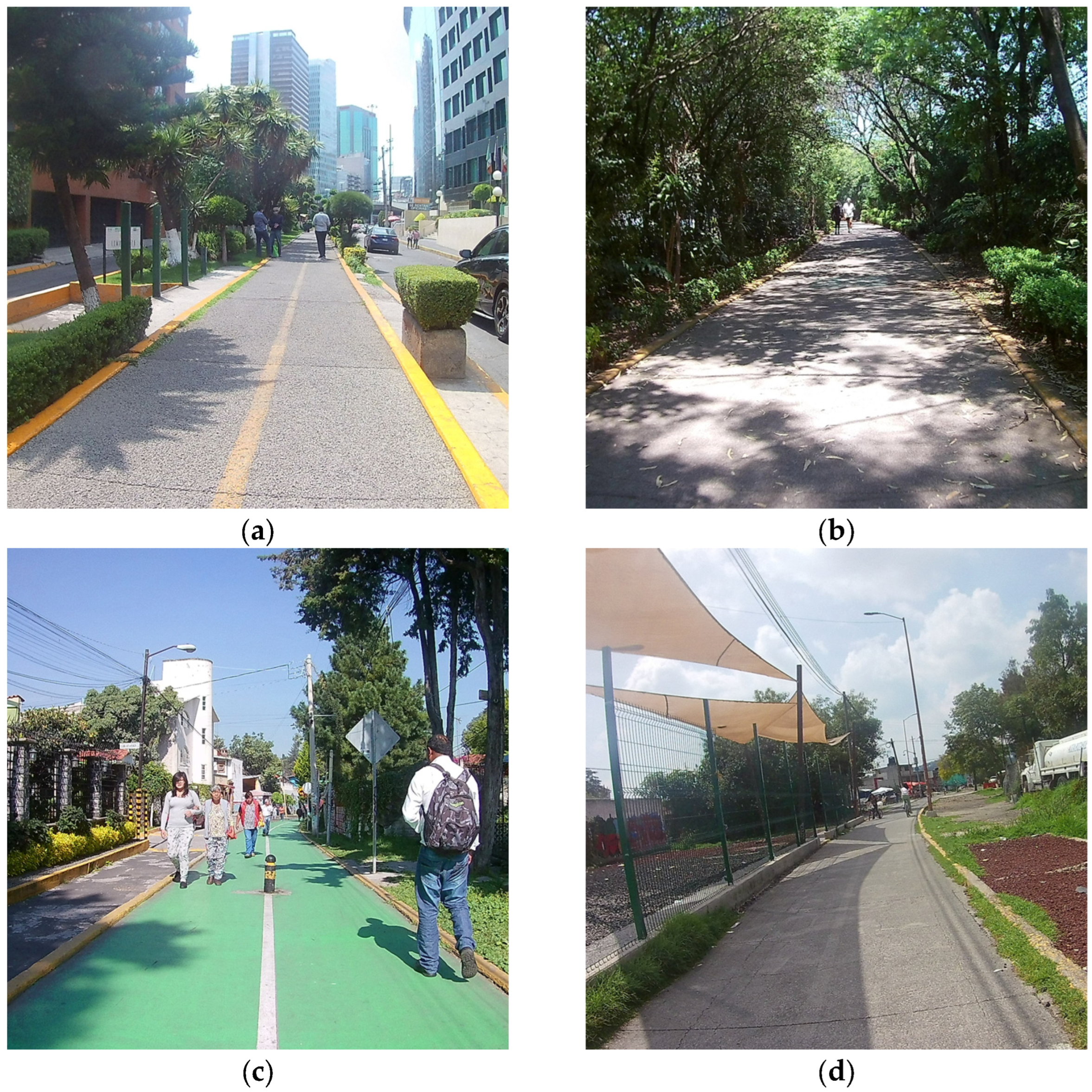
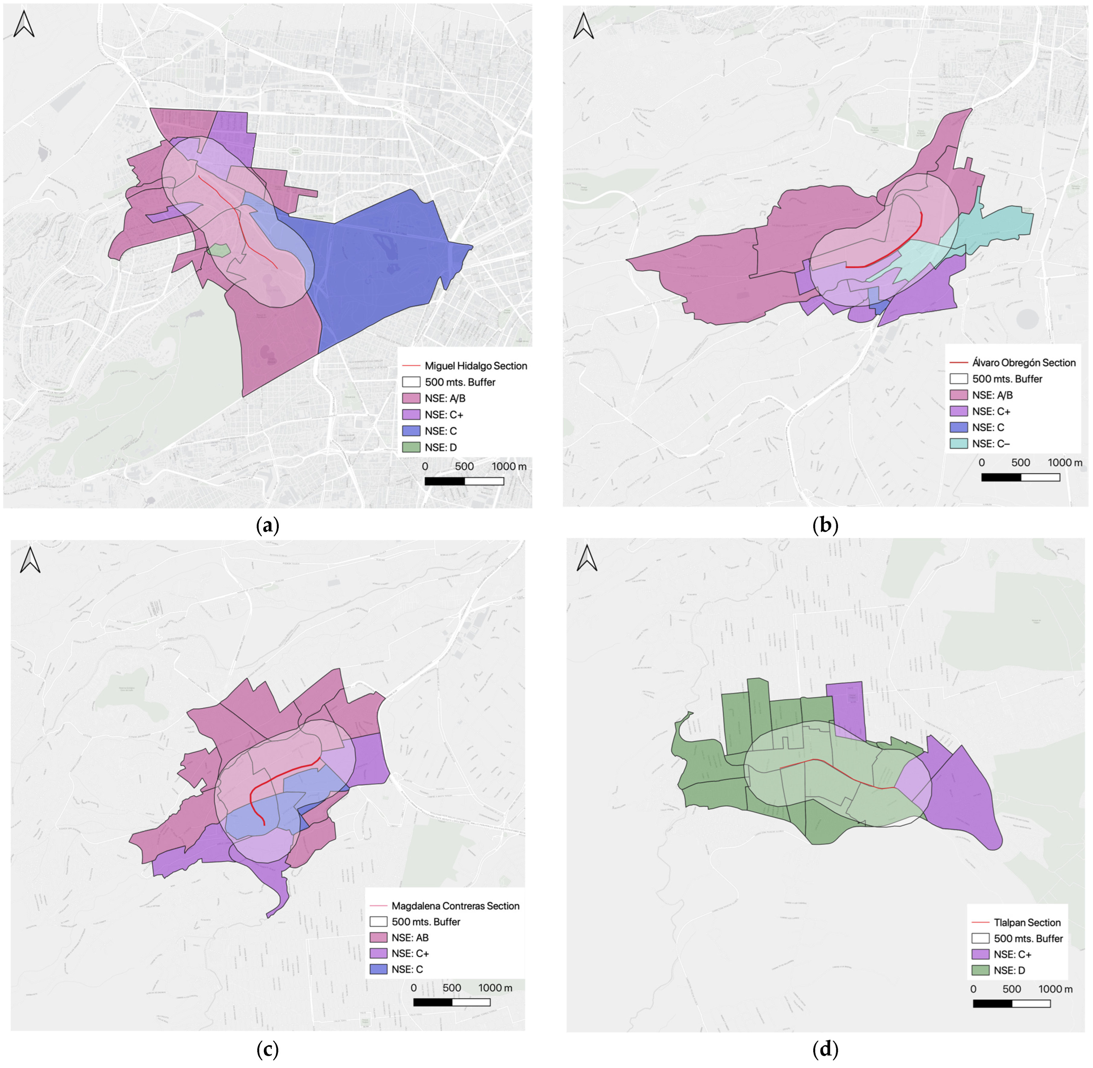
3.1. Characterization of Sections

“Miguel Hidalgo” section: from Boulevard Manuel Ávila Camacho to Fernando Alencastre Street (Figure 4a).
“Álvaro Obregón” section: from Cabrio Street to Don Manuelito Street (Figure 4b).
“Magdalena Contreras” section: from Querétaro Street to Francisco del Olmo Street (Figure 4c).
The “Tlalpan” section: from Tetiz Avenue to Lirios Street (Figure 4d).
The Miguel Hidalgo section of the linear park runs through modern high-rise office buildings and connects to major avenues, making it a crucial financial and touristic hub in Mexico City. This area is home to several significant monuments and museums, making it a site of numerous events and social celebrations, which underscores its cultural and economic significance. As shown in Table 1, the total area of the region is 7.5 km2, with a population density of 3067 inhabitants per km2. From a socioeconomic perspective, the majority of the population (71.4%) belongs to the highest level of socioeconomic status, while the rest are split between the second-highest level (14.3%), the middle level (7.1%), and the lowest level (7.1%).
Álvaro Obregón is marked by significant income inequality, with wealthy areas characterized by closed streets and privatized security, and areas of poverty and insecurity where using the linear park for walking or cycling is often difficult. Factories still line the linear park in this area. The total area of this section is 6.27 km2, with a population density of 9803 inhabitants per km2. In terms of socioeconomic status, the highest level and the second-highest level each comprise 38.5% of the population, with the middle level and second-lowest level making up 7.7% and 15.4%, respectively.
Magdalena Contreras, in contrast, is primarily residential, with fewer offices and buildings. Along the linear park, one can find various schools, both private and public. The area covers 5.38 km2 and has a population density of 11,772 inhabitants per km2. In terms of socioeconomic status, the majority of the population (64.7%) falls into the highest level, with the second- and third-highest levels comprising 17.6% each.
Tlalpan is the most underprivileged section of the four studied. It is primarily residential and contains several large bus parking lots and informal businesses. Tlalpan serves as a gateway to one of the peri-urban areas of Mexico City, and as a result, the region has a degraded urban environment with numerous land conflicts and violations of Mexico City’s prohibition of housing construction in protected natural areas. The area measures a total of 5.36 km2 and has a population density of 15,520 inhabitants per km2, with 80% of the population belonging to the lowest socioeconomic level and only 20% to the second-highest level. Figure 5 visually summarizes the NSE levels of each section.

3.2. Actors

As shown in the scheme of Figure 6, it should be noted that in “Ferrocarril de Cuernavaca”, various types of actors from different social status participated in the design, use and governance of urban infrastructure.
From 2002 to 2004, some members of the first advocacy groups for bicycles in Mexico City, Bicitekas A.C., were part of the team that designed and implemented the linear park under the direction of Mexico City’s Secretary for the Environment.
As A.S. explained in our interview: “We were several people who collaborated in this bicycle path/linear park; the landscape architect P.C.; the communicologist A.C., R.S., the biologist A.C., the architect P.M. and many other people, with great enthusiasm and few resources.” A.C. reported that the bike path over the Cuernavaca Railroad was Mexico City’s first of its kind: “No one knows who first thought of it, but there is documentation that this was a demand since the old days of the Mexico City Bicycle Movement in the 1980s. […] Good ideas have many fathers and mothers, sometimes it is hard to know who came up with a good proposal first, it usually takes the effort of hundreds or even thousands of people to make them come true. What matters is that they exist and make people’s lives better.” R.S. expressed the main effort during the start of that initiative: “It’s great that the people who live there can enjoy it by walking, running, or playing. And I prefer merchants shouting “what are you going to take” or even clothes hanging out, than cars. Sure, there would have to be better urban planning in some specific places. A strategic plan of political work with the leaders, a small investment in infrastructure on the sides of the bikeway, and a permanent program of supervision would achieve greater respect for those who travel the bikeway.” A.S. added “That stretch was about to become a street for cars, in fact, in a section of the second floor it is, this ended with the space (available for the linear park, ed.).”
After this first phase the role of municipal governments became more relevant as each municipality took charge of the eventual maintenance of the park. Through the years, the public investment in maintenance, renovation or installment of leisure and sport facilities has varied considerably among the different municipalities. “The character of the park is given by the quality and quantity of relations, and accessibility, as such, requires maintenance and much more investment. Of the 60 kms there are 30 rural kms well (maintained), about 5 unsafe, 3 kms “chic” in Polanco, the rest is like all Mexico and can be improved but with intention and public investment […]. The terrible “social closure” in our country, the same that does not allow a child to have access to education, housing, health, parks and bike paths in Mexico should not be reproduced in urban policies that feed inequalities, on the contrary, the linear park should be a flag for public investment (…) and for diversity” (A.S., interview).
Upon a review of the collected interview data, our research underscored a subsequent process implemented by each municipality’s mayor. This process displayed a stark dichotomy characterized by either a readiness to allocate local funds for the maintenance and establishment of new recreational spaces or a clear neglect, manifested through the deteriorating quality of furnishings and absence of intervention. This dichotomy was contingent upon the pressure exerted by the utilization of the infrastructure, whether it pertained to mobility, recreational activities, occupational requirements, or informality.

3.3. Uses, Exclusion, Rivalry, Appropriation, and Provisioning

Although this infrastructure was formally conceived as a bicycle path, intended exclusively for bicycles, over time it has become “[…] a long ecological corridor and a public space, both recreational area, non-motorized transport and environmental conservation space [...], a catalytic historical axis and a catalyst for the development of a new bicycle path [...], a catalytic and inclusive historical axis that connects in a 60 km route the central city with the urban periphery, and towards the city limits […], a central place for the public life of the neighborhoods it crosses, playing the role not only of a mobility axis, but of a space for meeting and development of diverse activities, in particular commercial activities” (UN-Habitat, 2018).
The different uses and perspectives of the linear park express the challenges of the reconciling public policy objectives, such as the creation of green spaces, with local needs, such as the promotion of the local economy, and the priorities of private actors involved in the design and implementation of urban infrastructure, such as the increase in land value. Public spaces and policy projects have been appropriated and re-signified by different users, as shown in Table 2. In this sense, it is relevant to underline how Ferrocarril de Cuernavaca is a space that was originally conceived for both cyclists and pedestrians who ride or walk through it daily to go to work or school and to take part in sports or as part of a ride, that through time has been appropriated according to the needs and idiosyncrasies of the neighbors of the different areas of the city it spans across.
Miguel Hidalgo is the section with the widest variety of uses and largest number of users, due to the existence of modern buildings with a high occupation density. The main use of the park in this section is pedestrian displacement of the employees of the many offices of national and transnational corporations located in the area. Recreational and sportive uses (such as running, cycling and walking with pets) of the linear park in this section are not relevant, and neither is the presence of children, which is partly due to the large presence of offices in the area and to the existence of larger public parts and green areas in the vicinity of the park, such as the two sections of the Chapultepec Park and the Reforma Corridor. Moreover, there exist expansive luxury shopping complexes within the area, wherein the median cost per meal significantly exceeds double the local minimum wage. This section has received large private investment in the maintenance of the park and its nearby areas. The perception of security in the area reported in the interviews is related to the presence of private security bodies, that operate as public security agents.
An important area of the linear park in the municipality of Álvaro Obregon had to be excluded from the fieldwork due to the conditions of insecurity, driven to a large extent by the prevalent policy abandon of this area. The interviewees reported cases of robbery with violence and a general fear to walk through some of the areas of this section. Not strangely, this is the less frequently used of the four areas considered in this work. It is also remarkable the low proportion of women walking in the Álvaro Obregon section and the very reduced recreational uses. It is also worth mentioning the existence of various fenced areas where the houses of families with higher income levels are placed, closing streets, providing private security and creating private appropriation of the public space. During the field work it was found that for many years, from February to April, particularly during windy months in the west of the city, groups of youngsters constantly flew many kites on two pedestrian bridges of the linear park. The number of kites was high enough to impede the passage of pedestrians and cyclist. Near the bridges there are areas occupied by homeless people, with a marked deterioration of the infrastructure. Nevertheless, many of the interviewees referred to the value of the park as a public space and to the absence of other public areas. In this section, there are closed streets as a private way to ensure security, where most of the people are excluded.
The section of Magdalena Contreras has been identified as having the highest level of recreational activity within the linear park, with a predominant presence of women and children, including walking with pets, cycling and running. The area is characterized by the presence of a diverse range of socioeconomic statuses, with lower-income areas being frequently occupied by informal food, clothing, and plastic vendors. While the section has undergone three maintenance interventions, including paving, installation, and/or the renovation of sports equipment, playgrounds, benches, and tables, the quality of infrastructure and presence of waste varies between different areas of the section.
The Tlalpan section of the park is distinguished by a significant presence of street markets (tianguis), occupying approximately 3.6 km of the linear park during weekends, attracting many consumers and vendors of various goods. This informal commerce plays a vital role in the livelihoods of many local families. Tlalpan is the second-largest section in terms of park users, with a higher proportion of women than men and a relatively high number of children present. Despite the limited availability of other public spaces in the area, the recreational use of this section of the park is restricted due to its current state of deterioration and lack of facilities, such as playgrounds, exercise machines, and urban furniture.
The working uses of the linear park generally pertain to the informal economy. In some areas of this section, there are food stands with sandwiches and yogurt cups in the morning, sweet bread in the afternoon, and garnachas (food consisting of small, fried, or grilled tortillas with various ingredients) in the evening, while fruit and vegetable trucks are located on the corners. Both in the Magdalena and Tlalpan sections, close to the linear park, there are pocket parks for physical activity. These modifications were developed to reduce the conflicts present on weekends between the installation of informal markets with many years of activity and the flow of recreational users in the upper part of the bikeway, that includes bike stations and resting places.

3.4. Collective Action—Policy Responses

The value given by local users to the linear park influences directly or indirectly the decisions regarding public investments. On the other hand, some local governors, particularly in the municipality of Magdalena, regardless of their political affiliation, found in the public expenditure on the park an area of political opportunity. According to the interviews, the pressure generated by users and neighbors in each area has been key for the recognition of the importance of those places by public actors. In some cases, this has become an area of opportunity in electoral terms to the administration in office. This is the case of the Magdalena Contreras section, one of the areas that has received the largest number of interventions by at least two local governments from different political parties.
These interventions, playgrounds, and outdoor exercise equipment, coherent with the mostly recreational use of this section, and the maintenance of some the most affluent areas of the Magdalena Contreras section, are promoted by local organized groups of women who walk in the park. In the less affluent area, the infrastructure and recreational equipment show signs of deterioration, and there is a presence of garbage on the streets.
There are collective actions in Tlalpan in the form of informal agreements on the use of public space occupied by the different vendors and their stalls in the street markets, and around the use of the public space of the linear park that during the weekends become a “highly rival good”. This is a more complex strategy of collective action that will lead to the total occupation of the space, with its actors imposing their own schemes on other types of users. Nevertheless, despite the general absence of public investments in the linear park, the dense occupation of the space by the street markets has prompted the municipality to try to improve the market installations, with investments in the creation of roofed surrounding areas for the passing of the flow of customers outside the transit zone for cyclists, where the infrastructure completely deteriorated shortly after the installation. Collective action around recreational use is not relevant in this section, despite of the fact that Tlalpan is the municipality with the youngest population (with a high proportion of children). It is noteworthy that this section of the park has not received any maintenance since its creation over nineteen years ago.
Collective action appears to be very limited in Álvaro Obregón, with no maintenance of the linear park by public, or private actors, particularly in the most deprived areas, resulting in a considerable level of environmental and social deterioration.

4. Discussion

The inequality present in the city is reflected in the different uses of the public space and in the unequal conditions of the infrastructure and security [59]. Recreational, cycling, and pedestrian uses tend to prevail in the most well-off areas, while informal commerce is the prevalent use in the deprived section of Tlalpan, an important livelihood option for many families, even if it only provides precarious jobs, with low remuneration, often based on family labor.
Urban commons—despite the public ownership of many of them, and the formal responsibilities of the State with their preservation—present frequent saturation and provision problems that translate into high levels of rivalry, exclusion, and risks of deterioration. In the cases of urban streets, each user has his or her own claims on the space, and strategies to occupy it, even if only temporarily; therefore, the space available for streets is considered finite, while different types of uses potentially compete [34,60].
The analysis of the different sections of the linear park shows the schemes of appropriation and resignification of cycling mobility infrastructure projects in Mexico City, expressing the needs and agency of different groups, as well as the reproduction of precariousness in a highly unequal city.
Over the years, this bicycle path has been the object of different interventions for its care and adaptation in some of its sections, while in others there is deterioration resulting from the de facto abandonment by the local administrations. This neglect reduces the incentives and commitments of local users with the sustainable use and preservation of the space, creating deterioration and conditions of insecurity, as seen in the section of Álvaro Obregon. Additionally, in the contexts of the marked elitism of the large Mexican cities, powerful actors tend to address the limited governmental capacities, “enclosing” or “privatizing” public spaces and goods [61,62], as in the cases of the closed streets in the section of Álvaro Obregon, or in the private security guards in Miguel Hidalgo. Processes of privatization often translate into “public evils”, such as exclusion and insecurity, mostly imposed on the poorest and most vulnerable, including many dwellers of Álvaro Obregón.
The distribution of and access to urban goods also reflect different values, cultures, and forms of local governance, inside a variety of types of commons expressed by the linear park (see Table 3). Thus, in different sections of some streets, one finds both highly formalized and regulated management schemes, as well as less formal forms of governance that respond to the conditions of the informal economy, low-income residential areas, and lack of planning. In this sense, it is worth mentioning, as an expression of collective action, the rather peaceful coexistence of different uses—such as transit, leisure, informal commerce and work—and the constant exchange of the priority of use agreed at any given moment [63,64,65]. This is the case of the section of Magdalena, where the linear park covers several areas of access to public schools. At times of high student influx, the stationing of many students is given priority, even if it impedes the flow of pedestrians and cyclists.
The existence and functionality of these assets and goods is the result of the intervention of governmental actions as well as that of different actors. The use and management of this space and of the different common goods that are produced, reproduced, enjoyed, and disputed there pose different problems of appropriation and provision, that relate to dilemmas of collective action. As mentioned above, the areas the park spans and the sections selected for this study are extremely heterogeneous. Not all the assets mentioned in the scheme are present or are important to all the social groups occupying the different sections.
Decision makers have assumed urban sustainability as an overarching goal; however, different stakeholders often have diverse perceptions of what constitutes the success or failure of a project and its possible alternatives. Hence, perspectives based exclusively on centralized planning and management are insufficient and even counterproductive for the solution of problems related to the sustained use and governance of urban commons, such as most urban spaces and assets. Even though guidelines have recently been developed to encourage citizen participation in the decision making and management of these projects, this has not translated into the development and implementation of effective and integrated tools to include stakeholders in the design, implementation and evaluation of the projects carried out.
Open-access parks and playgrounds have been considered “true” commons for having been intended for cost-free public use, seeking to provide a physical context for social interaction and connections, and for being subject to limitations derived from a use considered acceptable [67]. The Ferrocarril de Cuernavaca linear park was developed in the context of the de-industrialization of the city and was the first intervention to create cyclo-pedestrian infrastructure in Mexico City. As a linear park, it was also one of the first interventions aimed at advancing the achievement of the “right to the city” [68,69,70]. During its 20 years of existence, it has been a “living experiment” of the ways in which the transformation of infrastructure affects different spaces in the city and its communities.
Mexico, akin to its Latin American counterparts, has pledged to attain numerous urban sustainability goals. These include the advancement of infrastructure specifically designed for non-motorized transport and the establishment of accessible, inclusive public spaces and green areas. These commitments are embodied within the framework of Sustainable Development Goal 11 (SDG 11) of the 2030 Agenda, which is aimed at making cities and human settlements inclusive, safe, resilient, and sustainable. The crux of these efforts lies in ensuring equitable access to public spaces, thereby fostering a sense of community and promoting sustainable living. However, the path towards achieving these goals is fraught with various challenges. These difficulties stem from the inherent contradictions that exist between public spaces and green areas, which are not always accessible to all social groups. Despite their public nature, these spaces often become privy to select groups, thereby defeating their original purpose. One of the key reasons for this contradiction is the rising trend of public space management privatization. While this model can lead to well-maintained, secure spaces due to increased funding, it also tends to prioritize capital gains over equitable access and enjoyment. This approach often sees higher-end developments that cater to the affluent, while marginalizing lower-income groups who cannot afford to use these spaces. What were once intended as shared spaces that foster social cohesion and urban sustainability often transform into exclusive zones, exacerbating social inequalities. Additionally, the drive for capital gain can overshadow the sustainability aspect of these projects. There is a risk that green areas, designed to serve as urban lungs and biodiversity hotspots, may be compromised for lucrative infrastructural development. This contradiction stands as a roadblock to the realization of SDG 11 and other sustainability goals. The literature expresses the need to systematize these experiences, seeking to understand how “unexpected” and “unplanned activities” are generated, in order to produce useful, national and regional information [71,72,73]. In this sense, this case study can be seen as emblematic of what happens when the willingness to modify urban infrastructure for the sake of sustainability occurs in contexts of marked inequality, informality, insecurity, and unplanned urban growth that characterize Latin American cities. Addressing these challenges requires striking a delicate balance between private investment and public accessibility. It involves rethinking the current models of urban development and public space management.

5. Conclusions

While urban sustainable projects frequently represent a promising approach to green city development, these initiatives often grapple with the challenge of balancing profitability and accessibility, often falling prey to appropriation by real estate capital. This study aimed to delve deeper into these nuances, identify potential pitfalls, and propose viable solutions to these issues.
Our examination of the Ferrocarril de Cuernavaca linear park underscores social inequality as a pivotal factor in urban sustainability, as infrastructure development directly impacts the daily lives of city inhabitants. The notable disparities in mobility and public space accessibility in Latin America highlight the necessity for principles that guide infrastructure and public space development towards inclusivity and accessibility. To attain this, fostering participatory governance platforms is of the essence [74,75].
The Ferrocarril de Cuernavaca linear park, an initiative of civic society groups and the Mexico City government advocating for cyclist mobility, was envisioned to be a lasting addition to the city’s infrastructure. Yet, over time, unplanned interventions by local governments have sought to cater to emerging needs and uses. For instance, infrastructure has been modified to accommodate markets and pedestrians simultaneously, while “pocket parks” have been added along the walking–cycling trail, encouraging more diverse utilization of public space.
Considering the linear park as a common good—a shared space with limited exclusion and high rivalry—its preservation and potential to foster sustainability hinges on collective action and responsive policy interventions. However, as our analysis demonstrates, collective action around urban commons comes in various forms and the effectiveness of policy interventions is perceived differently among stakeholders. Therefore, gauging success requires a holistic view that considers policy responsiveness to local cultures, values, and needs. Despite the substantial socioeconomic disparities among residents in areas the linear park intersects, and the inconsistent quality of infrastructure across these areas, it is clear that the park enhances the quality of life for many of its users. It holds particular value in urban settings where access to public spaces is limited. Furthermore, the evolution of the linear park shares similarities with a growing global trend of urban space reappropriation aimed at fostering more humane environments [65].
In conclusion, the pursuit of a successful project should not be confined to a generalized view of sustainability. Rather, it should embrace the diversity of successful cases [76] and interpret success as the ‘heteronomy of ends’ that should accompany sustainable and inclusive development. From succumbing to gentrification due to surplus value creation [77], to project abandonment due to a lack of users, deterioration, and subsequent government inaction, sustainable urban requalification projects face a myriad of threats. This recognition is a vital step towards more effective and equitable sustainable urban development.

Author Contributions

Conceptualization, S.B. and L.M.-P.; methodology, S.B. and L.M.-P.; software, S.B.; validation, S.B. and L.M.-P.; formal analysis, S.B. and L.M.-P.; investigation, S.B.; data curation, S.B.; writing—original draft preparation, S.B. and L.M.-P.; writing—review and editing, S.B. and L.M.-P.; visualization, S.B.; supervision, L.M.-P.; funding acquisition, S.B. and L.M.-P. All authors have read and agreed to the published version of the manuscript.

Funding

This research was funded by Consejo Nacional de Ciencia y Tecnología (2020-1/2020-2) of the Mexican government and Proyecto PAPIIT AV300120 “Crisis ambiental en México y desigualdad”, of the Programa de Apoyo a Proyectos de Investigación e Innovación Tecnológica—Universidad Nacional Autónoma de México UNAM.

Institutional Review Board Statement

Ethical review and approval were waived for this study due to the installment of the Ethical Committee of the Postgraduate on Sustainability Science of Universidad Nacional Autónoma de México on date 13 April 2021, i.e., after the conduct of the study (https://sostenibilidad.posgrado.unam.mx/comite-etica/descripcion/, accessed on 21 March 2023).

Informed Consent Statement

All subjects gave their informed consent for inclusion before they participated in the study.

Data Availability Statement

The data presented in this study are available on request from the corresponding author.

Acknowledgments

The first author gratefully acknowledges the Program in Sustainability Sciences, UNAM (Posgrado en Ciencias de la Sostenibilidad, Universidad Nacional Autónoma de México).

Conflicts of Interest

The authors declare no conflict of interest.

References

  1. Janoschka, M.; Sequera, J. Gentrification in Latin America: Addressing the politics and geographies of displacement. Urban Geogr. 2016, 37, 1175–1194. [Google Scholar] [CrossRef]
  2. Vignoli, J.R. Movilidad cotidiana, desigualdad social y segregación residencial en cuatro metrópolis de América Latina. EURE 2008, 34, 49–71. [Google Scholar] [CrossRef]
  3. Sánchez Peña, L.L. Cambios en la Segregación Residencial Socioeconómica en México. Rev. Int. Estadística Geogr. 2012, 3, 98–115. Available online: http://www.inegi.org.mx/rde/RDE_06/Doctos/RDE_06_Art7.pdf (accessed on 6 December 2017).
  4. Sánchez-Peña, L.L. Alcances y Límites de los Métodos de Análisis Especial para el Estudio de la Pobreza Urbana. Pap. Poblac. 2012, 18, 147–179. [Google Scholar]
  5. Mollinedo, C.L. Movilidad urbana sostenible: Un reto para las ciudades del siglo XXI. Econ. Soc. Y Territ. 2006, 6, 1–35. Available online: https://www.redalyc.org/articulo.oa?id=11162202 (accessed on 21 March 2023).
  6. Hidalgo, D.; Huizenga, C. Implementation of sustainable urban transport in Latin America. Res. Transp. Econ. 2013, 40, 66–77. [Google Scholar] [CrossRef]
  7. Report of the United Nations Conference on Environment and Development. 1992. Available online: https://www.un.org/esa/dsd/agenda21/Agenda%2021.pdf (accessed on 21 March 2023).
  8. United Nations Sustainable Development Goals. (n.d.). Available online: https://sdgs.un.org/goals (accessed on 21 March 2023).
  9. Dempsey, N.; Bramley, G.; Power, S.; Brown, C. The social dimension of sustainable development: Defining urban social sustainability. Sustain. Dev. 2009, 19, 289–300. [Google Scholar] [CrossRef]
  10. Joss, S. Eco-cities: The mainstreaming of urban sustainability—Key characteristics and driving factors. Int. J. Sustain. Dev. Plan. 2011, 6, 268–285. [Google Scholar] [CrossRef]
  11. Connolly, J.J. From Jacobs to the Just City: A foundation for challenging the green planning orthodoxy. Cities 2019, 91, 64–70. [Google Scholar] [CrossRef]
  12. Anguelovski, I.; Connolly, J.; Brand, A.L. From landscapes of utopia to the margins of the green urban life. City 2018, 22, 417–436. [Google Scholar] [CrossRef]
  13. Anguelovski, I.; Connolly, J.J.; Garcia-Lamarca, M.; Cole, H.; Pearsall, H. New scholarly pathways on green gentrification: What does the urban ‘green turn’ mean and where is it going? Prog. Hum. Geogr. 2018, 43, 1064–1086. [Google Scholar] [CrossRef]
  14. Gottdiener, M.; Budd, L. Sustainable Urbanization. Key Concepts in Urban Studies; SAGE Publications: Thousand Oaks, CA, USA, 2013. [Google Scholar] [CrossRef]
  15. Karuppannan, S. Urban Planning and Sustainability in Developed and Developing Countries. In Proceedings of the 6th International Conference and Workshop on the Built Environment in Developing Countries, Adelaide, Australia, 4–5 December 2006; pp. 121–131. [Google Scholar]
  16. UN-Habitat. People and Mobility: Promoting Non-Motorised Transport Options and Compact Cities as Complements to Public Transport; UN-Habitat: Nairobi, Kenya, 2011. [Google Scholar]
  17. Campbell, S. Green Cities, Growing Cities, Just Cities? Urban Planning and the Contradictions of Sustainable Development. J. Am. Plan. Assoc. 1996, 62, 296–312. [Google Scholar] [CrossRef]
  18. Curran, W.; Hamilton, T. (Eds.) Just Green Enough: Urban Development and Environmental Gentrification; Routledge: London, UK, 2018. [Google Scholar]
  19. Ercan, M.A. Challenges and conflicts in achieving sustainable communities in historic neighbourhoods of Istanbul. Habitat Int. 2011, 35, 295–306. [Google Scholar] [CrossRef]
  20. De Sousa, C.A. Brownfields Redevelopment and the Quest for Sustainability; Elsevier: Amsterdam, The Netherlands, 2008. [Google Scholar]
  21. Zheng, H.W.; Shen, G.Q.; Wang, H. A review of recent studies on sustainable urban renewal. Habitat Int. 2014, 41, 272–279. [Google Scholar] [CrossRef]
  22. Ayala, A.A. Nuevo Polanco: Renovación Urbana, Segregación y Gentrificación en la Ciudad de México (Nuevo Polanco: Urban renewal, segregation and gentrification in Mexico). Iztapalapa Rev. Cienc. Soc. Humanid. 2016, 37, 101–123. [Google Scholar] [CrossRef]
  23. Olivera, P.; Delgadillo, V. Políticas empresarialistas en los procesos de gentrificación en la ciudad de México. Rev. Geogr. Norte Gd. 2014, 58, 111–133. [Google Scholar] [CrossRef]
  24. Delgadillo Polanco, V.M. El Derecho a la Ciudad en la Ciudad de México. ¿Una Retórica Progresista para una Gestión Urbana Neoliberal? Andamios 2012, 9, 117–139. Available online: http://www.scielo.org.mx/scielo.php?script=sci_arttext&pid=S1870-00632012000100006 (accessed on 18 February 2018). [CrossRef]
  25. Harris, B. The Invisible Walls of the 606: An Examination of the Relationship Between an Urban Greenway and Community Change, Clemson University. 2018. Available online: https://tigerprints.clemson.edu/all_dissertations (accessed on 15 August 2020).
  26. Harris, B.; Schmalz, D.; Larson, L.; Fernandez, M.; Griffin, S. Contested Spaces: Intimate Segregation and Environmental Gentrification on Chicago’s 606 Trail. City Community 2020, 19, 933–962. [Google Scholar] [CrossRef]
  27. Rigolon, A.; Fernandez, M.; Harris, B.; Stewart, W. An Ecological Model of Environmental Justice for Recreation. Leis. Sci. 2019, 44, 655–676. [Google Scholar] [CrossRef]
  28. Rigolon, A.; Németh, J. Green gentrification or ‘just green enough’: Do park location, size and function affect whether a place gentrifies or not? Urban Stud. 2019, 57, 402–420. [Google Scholar] [CrossRef]
  29. Rigolon, A.; Christensen, J. Greening without Gentrification: Learning from Parks-Related Anti-Displacement Strategies Nationwide. 2018. Available online: https://www.ioes.ucla.edu/project/prads/ (accessed on 29 December 2022).
  30. Loughran, K. Parks for Profit. Selling Nature in the City; Columbia University Press: New York, NY, USA, 2022. [Google Scholar]
  31. Ostrom, E. A General Framework for Analyzing Sustainability of Social-Ecological Systems. Science 2009, 325, 419–422. [Google Scholar] [CrossRef] [PubMed]
  32. Ostrom, E. Governing the Commons; Cambridge University Press: Cambridge, UK, 2015. [Google Scholar]
  33. Merino, L.; Cendejas, J. Peace building from a commons perspective. Int. J. Commons 2017, 11, 907. [Google Scholar] [CrossRef]
  34. Pasquier, A. Common Goods and Public Values in Changing Inter-Cultural Contexts in Europe. The ‘Piazzola’ Market, Bologna, Italy. In Governing Shared Resources: Connecting Local Experience to Global Challenges, the Twelfth Biennial Conference of the International Association for the Study of Commons; University of Gloucestershire: Cheltenham, UK, 2008; Available online: https://dlc.dlib.indiana.edu/dlc/bitstream/handle/10535/1954/Pasquier_Merino_202201.pdf?sequence=1&isAllowed=y (accessed on 19 March 2023).
  35. Hess, C. Mapping the new commons. In Proceedings of the Governing Shared Resources: Connecting Local Experience to Global Challenges, the 12th Biennial Conference of the International Association for the Study of the Commons, Cheltenham, UK, 14–18 July 2008. [Google Scholar] [CrossRef]
  36. Hess, C.; Ostrom, E. Understanding Knowledge as a Commons: From Theory to Practice; MIT Press: Cambridge, MA, USA, 2007. [Google Scholar]
  37. Gutscher, H.; Keller, C.; Mosler, H.J. Roads as new common pool resources, speed reduction as a public good—Two case studies in organizing large-scale collective action. In Proceedings of the Constituting the Commons: Crafting Sustainable Commons in the New Millennium, the Eighth Biennial Conference of the International Association for the Study of Common Property, Bloomington, IN, USA, 31 May–4 June 2000; Available online: http://dlc.dlib.indiana.edu/dlc/bitstream/handle/10535/1519/gutscherh041300.pdf?sequence=1&isAllowed=y (accessed on 18 October 2018).
  38. Huron, A. Theorising the urban commons: New thoughts, tensions and paths forward. Urban Stud. 2017, 54, 1062–1069. [Google Scholar] [CrossRef]
  39. Huron, A. Working with Strangers in Saturated Space: Reclaiming and Maintaining the Urban Commons. Antipode 2015, 47, 963–979. [Google Scholar] [CrossRef]
  40. Mehaffy, M.W.; Elmlund, P.; Farrell, K. Implementing the New Urban Agenda: The central role of public space. Urban Des. Int. 2019, 24, 4–6. [Google Scholar] [CrossRef]
  41. Merino, L. Perspectivas sobre la gobernanza de los bienes y la ciudadanía en la obra de Elinor Ostrom. Rev. Mex. Sociol. 2014, 76, 77–104. [Google Scholar]
  42. Frischmann, B.M. Infrastructure Commons in Economic Perspective. In Internet Policy and Economics; Springer: Boston, MA, USA, 2009; pp. 29–55. Available online: http://firstmonday.org/ojs/index.php/fm/article/view/1901/1783 (accessed on 13 April 2017).
  43. Ranking Ciclociudades 2021—ITDP México. Available online: https://mexico.itdp.org/download/ranking-ciclociudades-2021/ (accessed on 19 March 2023).
  44. Abrahamson, M. Studying Cities and City Life: An Introduction to Methods of Research; Oxon: Abingdon, UK; Routledge: New York, NY, USA, 2017; Available online: https://books.google.com.mx/books?hl=en&lr=&id=20AlDwAAQBAJ&oi=fnd&pg=PP1&dq=studying+cities+and+city+life&ots=1Ai8IDWC2N&sig=wnGjQhtGuig5jYiDZ71Z3iqLQ1M&redir_esc=y#v=onepage&q=studying+cities+and+city+life&f=false (accessed on 28 August 2020).
  45. Creswell, J.W.; Creswell, D.J. Research Design. Qualitative, Quantitative, and Mixed Methods Approaches, 5th ed.; SAGE: Los Angeles, CA, USA, 2018; Available online: https://us.sagepub.com/en-us/nam/research-design/book255675 (accessed on 28 December 2022).
  46. Sweetman, D.; Badiee, M.; Creswell, J.W. Use of the Transformative Framework in Mixed Methods Studies. Qual. Inq. 2010, 16, 441–454. [Google Scholar] [CrossRef]
  47. Gobierno de la Ciudad de México. Ubicación de Estaciones ECOBICI, Biciestacionamientos, Ciclovías y Puntos de Arribo de Monopatines Eléctricos y Bicicletas—Conjunto de Datos—Portal de Datos Abiertos de la CDMX. 2023. Available online: https://datos.cdmx.gob.mx/dataset/infraestructura-vial-ciclista (accessed on 19 March 2023).
  48. Instituto Nacional de Estadística y Geografía. Censo de Población y Vivienda 2020. 2020. Available online: https://www.inegi.org.mx/rnm/index.php/catalog/632/variable/F16/V523?name=AGEB (accessed on 26 February 2023).
  49. Sung, H.; Lee, S. Residential built environment and walking activity: Empirical evidence of Jane Jacobs’ urban vitality. Transp. Res. Part D Transp. Environ. 2015, 41, 318–329. [Google Scholar] [CrossRef]
  50. Gehl, J.; Svarre, B. How To Study Public Life, 2nd ed.; Island Press: Washington, DC, USA, 2013; ISBN 978-1-61091-423-9. [Google Scholar]
  51. PNUD; Ministerio de Vivienda y Urbanismo de Chile. La Dimensión Humana en el Espacio Público. Recomendaciones para el Análisis y el Diseño. 2017. Available online: http://biblioteca.digital.gob.cl/handle/123456789/232 (accessed on 21 March 2023).
  52. Asociación Mexicana de Agencias de Inteligencia de Mercado y Opinión. Índice de Niveles Socioeconómicos. 2022. Available online: https://www.amai.org/NSE/ (accessed on 26 February 2023).
  53. Evenson, K.R.; Jones, S.A.; Holliday, K.M.; Cohen, D.A.; McKenzie, T.L. Park characteristics, use, and physical activity: A review of studies using SOPARC (System for Observing Play and Recreation in Communities). Prev. Med. 2016, 86, 153–166. [Google Scholar] [CrossRef]
  54. Joseph, R.P.; Maddock, J.E. Observational Park-based physical activity studies: A systematic review of the literature. Prev. Med. 2016, 89, 257–277. [Google Scholar] [CrossRef] [PubMed]
  55. Cohen, D.A.; Setodji, C.; Evenson, K.R.; Ward, P.; Lapham, S.; Hillier, A.; McKenzie, T.L. How Much Observation Is Enough? Refining the Administration of SOPARC. J. Phys. Act. Heal. 2011, 8, 1117–1123. [Google Scholar] [CrossRef]
  56. Medina, C.; Hernández, A.; Hermosillo-Gallardo, M.E.; Gámez, C.I.G.; Resendiz, E.; Morales, M.; Nieto, C.; Moreno, M.; Barquera, S. Development and Validation of the Mexican Public Open Spaces Tool (MexPOS). Int. J. Environ. Res. Public Health 2022, 19, 8198. [Google Scholar] [CrossRef]
  57. Salvo, D.; Reis, R.S.; Stein, A.D.; Rivera, J.; Martorell, R.; Pratt, M. Characteristics of the Built Environment in Relation to Objectively Measured Physical Activity Among Mexican Adults, 2011. Prev. Chronic Dis. 2014, 11, E147. [Google Scholar] [CrossRef]
  58. Padilla Galicia, S. Morfología Urbana de Nuevo Polanco. El Caso Específico de la Ampliación Granada; Universidad Autónoma Metropolitana: Mexico City, Mexico, 2020. [Google Scholar]
  59. Castro-Coma, M.; Martí-Costa, M. Comunes urbanos: De la gestión colectiva al derecho a la ciudad. EURE 2016, 42, 131–153. [Google Scholar] [CrossRef]
  60. Dienel, H.L.; Jain, A.; Bonaker, A. Road space in Hyderabad as an Urban Common: Otto von Gierke’s cooperative law applied to the discussion on the use of road space in Hyderabad. In Proceedings of the Sustaining Commons: Sustaining Our Future, the Thirteenth Biennial Conference of the International Association for the Study of the Commons, Hyderabad, India, 10–14 January 2011; pp. 1–15. [Google Scholar]
  61. Foster, S.R.; Iaione, C. The City as a Commons. Yale Law Policy Rev. 2016, 34, 281–349. [Google Scholar]
  62. Foster, S.R.; Iaione, C. Ostrom in the city design principles and practices for the urban commons. In Routledge Handbook of the Study of the Commons; Routledge: New York, NY, USA, 2019. [Google Scholar] [CrossRef]
  63. Chen, M.A. Managing the urban commons: What space for informal livelihoods? What role for organizations of informal workers? In Proceedings of the Informality and Development: A Conference in Honor of Elinor Ostrom, Bloomington, IN, USA, 22–23 October 2016; Available online: https://dlc.dlib.indiana.edu/dlc/bitstream/handle/10535/10162/Chen%2c%20Martha_Managing%20the%20Urban%20Commons.pdf (accessed on 21 March 2023).
  64. Lombard, M.; Huxley, M. Self-made cities: Ordinary informality. Plan. Theory Pract. 2011, 12, 120–125. [Google Scholar]
  65. Porter, L.; Lombard, M.; Huxley, M.; Ingin, A.K.; Islam, T.; Briggs, J.; Rukmana, D.; Devlin, R.; Watson, V. Informality, the Commons and the Paradoxes for Planning: Concepts and Debates for Informality and Planning. Plan. Theory Pract. 2011, 12, 131–137. [Google Scholar] [CrossRef]
  66. Feinberg, A.; Ghorbani, A.; Herder, P. Diversity and Challenges of the Urban Commons: A Comprehensive Review. Int. J. Commons 2021, 15, 1–20. [Google Scholar] [CrossRef]
  67. Boydell, S.; Searle, G. Understanding Property Rights in the Contemporary Urban Commons. Urban Policy Res. 2014, 32, 323–340. [Google Scholar] [CrossRef]
  68. Lefebvre, H. Le droit à la ville. Homme Société 1967, 6, 29–35. [Google Scholar] [CrossRef]
  69. Harvey, D. The right to the city. Int. J. Urban Reg. Res. 2003, 27, 939–941. [Google Scholar] [CrossRef]
  70. Sheller, M. Mobility Justice: The Politics of Movement in an Age of Extremes; Verso: London, UK, 2018; Available online: https://books.google.com.mx/books?hl=en&lr=&id=VvhsDwAAQBAJ&oi=fnd&pg=PR7&dq=mimi+sheller&ots=kZdQk-H2ae&sig=tNmRkFWCNubKUkeu3rLjL6hNQ8M&redir_esc=y#v=onepage&q=mimi%20sheller&f=false (accessed on 20 March 2023).
  71. Kevin, D.; Fisher, A.; Kingsbury, B.; Merry, S.E. Governance by Indicators: Global Power Through Classification and Rankings, Law and Global Gove; Oxford University Press: Oxford, UK, 2012; Available online: https://books.google.com.mx/books?hl=en&lr=&id=oEN8jOw1v9oC&oi=fnd&pg=PP1&dq=Governance+by+Indicators:+Global+Power+Through+Classification+and+Rankings&ots=qcnOWsBFeH&sig=_pmb0ebIqWrQY09QbSBotyHiIhM&redir_esc=y#v=onepage&q=Governance%20by%20Indicators%3A%20Global%20Power%20Through%20Classification%20and%20Rankings&f=false (accessed on 1 February 2023).
  72. Elgert, L. Rating the sustainable city: ‘Measurementality’, transparency, and unexpected outcomes at the knowledge-policy interface. Environ. Sci. Policy 2018, 79, 16–24. [Google Scholar] [CrossRef]
  73. Myers, G. From expected to unexpected comparisons: Changing the flows of ideas about cities in a postcolonial urban world. Singap. J. Trop. Geogr. 2014, 35, 104–118. [Google Scholar] [CrossRef]
  74. Zunino Singh, D. Términos Clave para los Estudios de Movilidad en América Latina; Biblos: Buenos Aires, Argentina, 2018. [Google Scholar]
  75. Arvanitidis, P.A.; Papagiannitsis, G. Urban open spaces as a commons: The credibility thesis and common property in a self-governed park of Athens, Greece. Cities 2020, 97, 102480. [Google Scholar] [CrossRef]
  76. Sennett, R.; Burdett, R.; Sassen, S. The Quito Papers and the New Urban Agenda, 1st ed.; Routledge: New York, NY, USA, 2018; pp. 1–105. [Google Scholar] [CrossRef]
  77. Black, K.J.; Richards, M. Eco-gentrification and who benefits from urban green amenities: NYC’s high Line. Landsc. Urban Plan. 2020, 204, 103900. [Google Scholar] [CrossRef]
Figure 1. Map of the linear park. Red line is the Ferrocarril de Cuernavaca linear park. Solid black areas are the sections under study, from North to South: “Miguel Hidalgo”, “Álvaro Obregón”, “Magdalena Contreras”, and “Tlalpan”.
Sustainability 15 09542 g001
Figure 2. Selected photos from the different sections: (a) “Miguel Hidalgo” section; (b) “Álvaro Obregón” section; (c) “Magdalena Contreras” section; (d) “Tlalpan” section (photos: authors).
Sustainability 15 09542 g002
Figure 3. Length of cycling infrastructure built per year from 2004 to 2022 in Mexico City.
Sustainability 15 09542 g003
Figure 4. (a) “Miguel Hidalgo” section; (b) “Álvaro Obregón” section; (c) “Magdalena Contreras” section; (d) “Tlalpan” section.
Sustainability 15 09542 g004
Figure 5. Summary of NSE levels in percentage for each section.
Sustainability 15 09542 g005
Figure 6. Intersectoral linkage in the framework of non-motorized mobility projects. Source: personal elaboration based on field work.
Sustainability 15 09542 g006
Table 1. Summary of NSE levels, area, population, and density for each section.
Miguel HidalgoÁlvaro ÓbregónMagdalena ContrerasTlalpan
NSEN. of NSEArea (km2)PopulationDensityN. of NSEArea (km2)PopulationDensityN. of NSEArea (km2)PopulationDensityN. of NSEArea (km2)PopulationDensity
A/B105.3018,904503353.0725,7577038113.7440,65511,029
C+20.491914274152.3420,087982730.8212,27318,32630.7511,23014,410
C10.041335610.13256919,37730.82984412,467
C−11.6726515920.73805312,118
D+
D 124.6077,72617,064
E
Table 2. Demographic distribution and user activity patterns across the sections “Miguel Hidalgo”, “Álvaro Obregón”, “La Magdalena Contreras”, and “Tlalpan”.
Miguel
Hidalgo
Álvaro ObregónLa Magdalena
Contreras
Tlalpan
Adults235063111971490
Children1375160197
Male1308435624797
Female1055271733890
Total of Users236370613571687
Runners121115910
Still37674169
Pedestrian21174807351366
With pets264325416
Bicycling17195170127
Table 3. The linear park as an articulating space for urban common goods. Classification adapted from Feinberg [66].
Main Sector of CommonsSub-Sector 1Sub-Sector 3
Infrastructure commonsTransportation
Budgets
Markets as commonsExchange commons
Global commonsAtmosphere
Pollution
Public health
Infrastructure
Social Commons
Neighborhood commonsHomeless habitat
Parks and greenery
Security
Sidewalks
Streets
Silence/Noise
Cultural commonsNon-profit organizations
Public arts
Sports
TourismLandscapes
Eco-tourism
Disclaimer/Publisher’s Note: The statements, opinions and data contained in all publications are solely those of the individual author(s) and contributor(s) and not of MDPI and/or the editor(s). MDPI and/or the editor(s) disclaim responsibility for any injury to people or property resulting from any ideas, methods, instructions or products referred to in the content.

