Article

Potential for Tourism and Recreation in the Todzhinsky Kozhuun (District), Republic of Tyva, RF

1
Institute of Earth Sciences, University of Tyumen, 2, Osipenko Street, Tyumen 625002, Russia
2
V B Sochava Institute of Geography SB RAS, 1, Ulan-Batorskaya Street, Irkutsk 664033, Russia
3
Institute of High Technology, Irkutsk National Research Technical University, 83, Lermontova Street, Irkutsk 664074, Russia
4
Institute of Information Technology and Data Science, Irkutsk National Research Technical University, 83, Lermontova Street, Irkutsk 664074, Russia
5
Baikal Institute of Nature Management, SB RAS, Sakhyanovoy Street 6, Ulan-Ude 670047, Russia
*
Author to whom correspondence should be addressed.
Sustainability 2023, 15(14), 11087; https://doi.org/10.3390/su151411087
Submission received: 21 May 2023 / Revised: 4 July 2023 / Accepted: 4 July 2023 / Published: 16 July 2023
(This article belongs to the Collection Tourism Research and Regional Sciences)

Abstract

:
The paper reveals opportunities and limitations of tourism development in one of the most inaccessible areas in the mountains of Southern Siberia: Todzhinsky kozhuun, Republic of Tyva, RF. Taking into account key indicators that reflect the natural, historical, cultural, and socio-economic characteristics of the territory, using GIS technologies, a comprehensive assessment and mapping of the tourism and recreational potential (TRP) of the territory was carried out. The method of multicomponent scoring was used in this work. Consequentially, the study area was divided by means of a regular hexagonal network into many operational territorial cells; for each of those, the sum of scores was calculated according to the conditions and objects that are localized within its boundaries. The set of operational territorial cells filled with visual information made it possible to create an assessment map of the tourism and recreational potential of the Todzhinsky kozhuun territory. This map highlights the areas of the five value ranks, from the highest to the lowest. The areas with the highest scores are obviously the most suitable for the development of tourism industry. In general, the basis of the region’s TRP is picturesque virgin natural landscapes with many large lakes, unique traditional ethnocultural landscapes of the mountain–taiga reindeer herders, biological resources for hunting and fishing, and healing mineral springs (arzhany). The key limiting factor in the development of tourism is the underdeveloped transportation system and the insufficiency of special tourism infrastructure facilities. Such an assessment made it possible to identify territories favorable for the creation of three specialized tourist clusters: ethnocultural tourism, “Reindeer herders of Todzhi”; water, ecological, and fishing tourism, “Todzha Lakes”; and mountain and sports tourism, “Big Sayan”.

1. Introduction

In today’s globalizing world, where cultural differences between different ethnic groups and cultural landscapes are increasingly blurred and with enforcing anthropogenic pressure on the natural environment, the value of territories where untouched natural and traditional cultural landscapes have been preserved is growing. Such regions often become centers of tourist interest, as they can offer opportunities to immerse individuals into virgin nature as well as into the authentic cultural environment of local ethnic communities [1,2,3,4,5,6].
One of these regions is the Republic of Tyva, located in the geographical center of Asia, far from major transportation communications. A spectrum of picturesque poorly developed mountain landscapes of the Altai-Sayan mountainous country, wide biological diversity, and preserved traditional culture of the nomads of the Great Steppe and mountain–taiga reindeer herders create unique conditions for educational, ecological, fishing, and sports tourism.
At the same time, Tyva is one of the most socio-economically depressed regions of Russia. After the collapse of the USSR, there was a break in many economic ties and the privatization and redistribution of assets, which led to the wave of bankruptcies of key industrial and agricultural enterprises. The peripheral position and infrastructural underdevelopment of the territory exacerbated the situation, provoking some of the highest rates of unemployment, poverty, and related social deviations in the country (e.g., drunkenness, drug addiction, crime) [7,8,9,10,11,12,13].
Tourism is considered one of the priorities for the social and economic development of Tyva in this respect [14,15,16,17]. It is assumed that a stable tourist flow will ensure employment in the rural areas of the region not only due to the objects of the tourism industry directly (hostels, hotels, tour agencies, rental offices, etc.) but also those of related industries (transportation, catering, retail trade, etc.). One can expect additional opportunities for the marketing of agricultural products and products of local crafts as well.
Currently, with the peak demand of domestic tourism in Russia, traditional tourist destinations are experiencing unprecedented pressures with the tourist flows increasing several times. In this regard, the development of new tourist destinations seems that it would be especially successful.
However, tourism in Tyva has been realized mainly on a spontaneous basis so far, and tourist flows are generally insignificant and unstable. This is due, first of all, to the underdevelopment of transportation and special tourism infrastructure and limited investment in the industry. Therefore, at present, an extremely urgent task is to identify areas with the highest concentration of tourism and recreational potential (TRP), where investing in tourism infrastructure will give the greatest effect. Accordingly, a science-based comprehensive assessment of TRP is essential.
The largest territorial unit of the Republic of Tyva possessing the most diverse natural and cultural features is the Todzhinsky kozhuun (district) located in the east of the region.
The purpose of this study is a comprehensive assessment and mapping of the tourism and recreational potential of the Todzhinsky district of the Republic of Tyva.
To achieve this goal, the following tasks were completed:
  • Development of a methodology for a comprehensive assessment of tourism and recreational potential, which makes it possible to take into account many significant heterogeneous characteristics of a natural, historical, cultural, and socio-economic nature.
  • Implementation of procedures for assessing and mapping the TRP of the study area, using available cartographic, documentary (registries and passports of objects, etc.) materials and the results of expeditionary research.
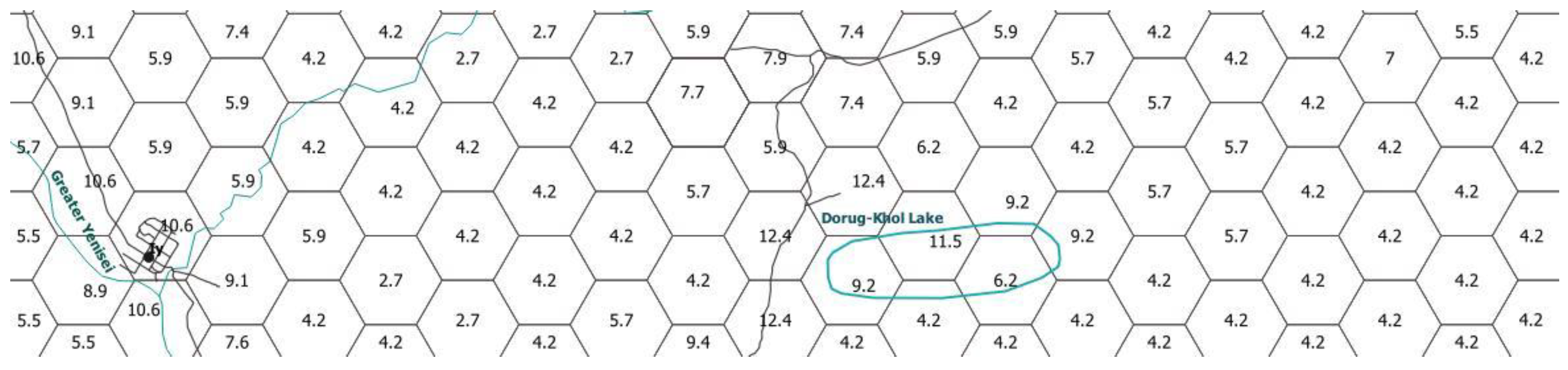
  • Analysis of the results of assessment and identification of the regularities in spatial differentiation within the Todzhinsky district in terms of the TRP value for the determination of the most promising areas in the district for tourism and recreational development.

2. Related Works

The spatial organization of tourism and recreation on a territory is always preceded by an assessment of its TRP. It is the mainstreaming and characterization of the set of tourism and recreational resources, opportunities, and limitations for economic development that determines the specialization and nature of the function of a future territorial recreational system in any region.
In addition, TRP assessments are always accompanied by methodological difficulties due to the complexity of the subject of evaluation and the diversity in the use of different types of resources. In this regard, there is a wide variety of approaches and assessment methods proper for the analysis of certain types of TRP and of the territory as a whole [18,19,20,21,22,23,24,25].
It should be noted that the theoretical and methodological foundations for assessing territorial TRP were laid by representatives of the Soviet School of Recreational Geography in the 1960s and 1980s [3,11,16,26,27,28,29,30,31].
Most of the methods for assessing TRP are focused on scoring territorial complexes, although there have been attempts at economic assessments of tourism and recreational potential, expressed in monetary terms [18,32,33,34].
At the same time, in the practice of the recreational assessment of a territory, a component-industry approach prevails. This approach envisages the suitability of an area for a particular type of tourism, and recreational activity is analyzed, or only one or several components (properties) of the territorial complex (and mainly of natural origin) are studied through the lens of their tourism and recreational significance. Within the framework of this approach, three main types of recreational assessments of a territory can be distinguished: medico-biological, psychological–aesthetic, and technological.
The medico-biological type reflects natural factors’ comfort and their impact on the human body. The leading role is played by an assessment of recreational climatic resources [27,35,36,37].
Psychological and aesthetic assessments examine the emotional impact of distinctive features of the natural landscape or its components on a person. It is known that recreational areas with high aesthetic value are in high demand. Within the framework of this approach, the papers [26,27,38,39,40,41,42] are especially noteworthy.
Technological assessments include issues of engineering and technology for the use of natural and other resources for tourism and recreational activities in general, one or another type of recreational activities, and an assessment of the possibilities of engineering and construction development of territories for the creation of recreational institutions [30,43,44,45,46].
A methodology for a comprehensive assessment of the tourism and recreational potential of a territory was first proposed by the authors of [47]. They took into account mainly the natural features of a territory, cultural and historical monuments, and transportation accessibility. Further, many authors proposed their own versions of the method for the complex assessment of TRP [48,49,50,51,52], but, in essence, they were quite similar. Thus, a territory is divided into certain areas (landscapes, tracts, regular operational cells), each of which is evaluated according to given significant indicators, the values of which give a certain score. Next, the scores are summed up, and they represent the general estimated characteristic of the analyzed area. Dividing the difference between the maximum and minimum estimated values of all areas into some intervals of scores allows us to rank these areas according to the degree of tourism and recreational suitability (i.e., by the value of TRP). The system of evaluation indicators is developed by each author independently. At the same time, researchers try to take into account as much as possible all the factors that determine the tourism and recreational attractiveness of a territory.
The most detailed and multifactorial methods were proposed in the works [53,54,55,56].
The study [55] used the methods of integral assessment of the tourism and recreational potential to characterize natural, historical, cultural, and socio-economic aspects. The magnitude of the natural and historical–cultural components of the potential is proposed to be measured on the basis of the dimensions and attractiveness of the territory’s heritage. Based on these components, territorial concentration and level of significance of monuments included in the natural and cultural heritage of the territory and fixed in regulatory documents are determined. According to the specific significance of these objects, scores are calculated.
When assessing the socio-economic component of potential, two independent parts are distinguished: transportation and special tourist infrastructure. Road density serves as a key metric in assessing the role of transportation. The assessment of the tourism infrastructure level is carried out by calculating the indicator that reflects the ratio of the number of accommodation and catering enterprises to the population of the territory. The author gave examples of calculating scores for each component and also stipulates the methodology for calculating correction factors (for example, regarding the information component of tourism and recreational potential, image characteristics of objects) [55].
The complex assessment methodology proposed by [34] is based on the following considerations: (1) the prospects of the territory for the development of various types of tourism in it (active, business, cultural, educational, etc.); (2) transportation accessibility—the density of roads and the remoteness of the territory from the starting point of the tourist route; (3) the complexity of tourist resources and their combination (landscape boundaries, contrast, diversity of relief, monuments of nature, culture, accommodation, and food); (4) density of tourist resources; (5) service, hospitality, and informatization (the minimum required level is determined); (6) tour operation (the presence of well-established routes that have been functioning for a long time); and (7) a combination of priority tourism areas (territorial location of promising tourist areas relative to each other). The authors distinguished the following stages, in which specific research methods are used: (1) building a cartoid; (2) determining the list of priority areas, or territories; (3) compiling a cadaster of tourist resources of selected territories; (4) applying SWOT analysis of selected territories; and (5) checking for objectivity (the results of the matrix analysis are compared with the results of the scoring) [56].
For a comprehensive assessment of the tourism and recreational potential of the region, Sarancha [57] used a GIS analysis of the territory. He developed an algorithm for a geoinformation assessment of the territory using the system of “operational territorial units” (OTU). The main evaluation factors (total of 103 indicators) in the methodology are the diversity of landscapes and their recreational attractiveness; the density and intensity of functioning of intercity and suburban bus routes; the density and significance of architectural, archaeological, and historical monuments; the availability and status of specially protected natural areas; the density of sports facilities, their type (15 types in total), and their capacity; the presence and number of children’s health camps and sanatorium-prophylactic institutions; the presence of tourist routes of various types (hiking, horseback riding, water, automobile, and skiing); horticultural and summer cottages; the distribution of the main commercial species of animals and the number of their prey; museums; theatres, circus, film installations; houses and recreation centers; and hotels [57].
The methodology of [54] is based on the application of a balanced approach in the evaluation of TRP. The algorithm includes scoring sets of natural, historical, cultural, and socio-economic factors, as well as those of the environmental situation and adverse ones. Each set consists of interrelated assessment components; the set of natural factors includes bioclimatic, hydrological conditions of the territory, relief, etc. In turn, the components contain a group of parameters (for example, the duration of the summer comfortable period, the frequency of favorable weather for swimming, and others). The full list of evaluation factors includes 128 indicators. The outcome of calculating TRP by the balance method was the final balance of the potential, which is composed not of the scores but of the shares of each set. The results were grouped by natural boundaries automatically in the ArcGIS program [54].
However, most of the currently available works devoted to the assessment of the TRP of the territory, along with their many advantages, are also characterized by typical shortcomings:
  • Insufficient consideration of the economic and socio-cultural components of the tourism and recreational potential. In most works, in a comprehensive assessment of TRP, at best, transportation provision (through indicators of the density of the transportation network) and the presence of objects of historical and cultural heritage (monuments of architecture, archeology, etc.) are taken into account. Meanwhile, indicators of the availability of resources and facilities (not only transportation but also financial, infrastructural, etc.), the provision of tourism infrastructure facilities, labor resources, information saturation, tolerance of the local population of tourist destinations, etc. are the most important characteristics of this areas of activity.
  • Absence (when all territorial factors significant for the development of tourism are recognized as equal in their role) or insufficient substantiation of weight coefficients in the estimated indicators. They, as a rule, are set by the authors arbitrarily without calculations and justifications, or they are the results of logical conclusions and conceptual assumptions. In this regard, it is important to search for possibilities of an objective scientifically based ranking of all estimated indicators according to their degree of significance.
  • Weakness, in general, of the level of automation of evaluation processes, especially considering the existing opportunities for large-scale application of GIS modeling in this area.
  • Abstractness of many evaluation works of the Russian scientific school, specifically their poor linkage to practical activities (unlike other world analogues), in particular, to territorial planning for development of tourism and recreational facilities.
Globally, the development of the methodology for assessing tourism and recreational potential has also been going on for more than a dozen years. A review of recent works within the domain shows a trend of transition to quantitative methods of assessment, which could bring the procedure closer to the objectivity and comparability of the results obtained for different territories [58]. Since the assessment of tourism potential is multifaceted [59,60,61,62], the choice of criteria is the first and a very important stage of this entire procedure [61]. In general, the sets of criteria in the works of different authors overlap in many respects, but there are also quite original approaches to the evaluation of TRP and the choice of evaluation criteria itself. For example, a methodology for estimating TRP based on a comparison of the number of views of videos about the locations under study in Google and YouTube has been proposed [63]. Notably, weighing the criteria for tourism potential is a difficult task for a multi-criteria assessment. Therefore, special attention is paid to the issues of comparability and significance of the selected evaluation criteria and the assignment of differentiated weighting coefficients [64].
Widely mentioned in the world’s literature is the approach to assessing tourism potential that combines geographic information systems (GIS), the process of analytical hierarchy, and the principal component method (PCA), which uses a certain number of alternatives and takes into account multi-criteria goals [58,61,65].
The authors of [64,66] emphasize the role of the time aspect in assessing tourism potential, including the importance of taking into account tourist flow seasonality, especially in the context of sustainable development, when tourism is a key factor of employment for the local population.
As for the assessment of tourism and recreational potential of the territory of the Republic of Tyva (or its certain districts) or regions similar to it, most of the research has been done for the Republics of Altai and Buryatia, and similar works are being conducted quite actively in Khakassia and the Kemerovo region. The evaluation of TRP for Tyva is just in its beginning. There are several review publications devoted to this topic [16,67,68,69], which, of course, is not enough for the effective organization of a full-fledged tourism–recreational economy. Therefore, the relevance of such studies seems extremely high.

3. Materials and Methods

In this study, the evaluation methodology proposed by [53] has been applied.
This methodology is based on the position of the need to take into account factors that are diverse in genesis and form of their manifestations, which have one or another effect on recreational activities. Accordingly, general (integral) tourism and recreational potential of a territory should be calculated for each factor.
For possible joint evaluation of such diverse indicators, a scoring approach is used, in which one or another manifestation of a certain evaluation factor allows the evaluation of its contribution to the TRP of a territory by a certain number of scores.
In addition, it is obvious that the roles of various factors in the total TRP of a territory are not the same. This fact requires introduction of correction weighting factors that increase or decrease the share of the assessment of the analyzed factors in the final score.
In the use of this technique, cartographic material for the study area is of great importance. Cartographic information is represented by separate GIS layers depending on the type of objects: points, lines, or squares. The following layers serve as a digital map base for the formation of a recreational GIS: administrative division, hydrography and settlements, relief and communication routes, vegetation contours, etc.
Within development and verification of the methodology for comprehensive assessment of the tourism and recreational potential of a territory, the next stages are comprised:
Stage 1. Organization of an expert survey to compile a list of principal evaluation factors and determine the threshold values of weighting coefficients. The evaluation indicators were selected by the authors based on the method of expert evaluations. The expert survey envisages involvement of independent experts—highly qualified and recognized specialists in the field of recreation and tourism. Based on the opinions of experts, a list of indicators potentially significant for the recreational assessment of the territory is compiled. The results are summarized in the form of a matrix representing evaluation factors with variants of their manifestation and corresponding scores.
In total [60], more than 30 indicators were analyzed, grouped into three categories: (1) natural factors—19 indicators; (2) cultural and historical factors—3 indicators; (3) socio-economic factors—9 indicators (Table 1). This was followed by ranking the obtained factors according to their degree of significance, as well as identifying those characteristics of the territory that have no direct connection with its tourism and recreational potential. To solve this problem, the analytic hierarchy process (AHP) was used, based on a pairwise comparison of values of all the indicators on an ordinal scale (scores are from 1 to 9) and the subsequent conversion of qualitative comparisons into quantitative estimates. A feature of the AHP is the possibility of obtaining grades on a metric scale based on the subjective opinions of experts [70].
The result of applying the method is the synthesis of multiple judgments and the prioritization of options. The analytic hierarchy process provides a mathematically correct and rigorous procedure for calculating priorities of indicators. Experts carry out pairwise comparisons of all potentially significant indicators using specially prepared questionnaires. Further, the data from the questionnaires are transferred to the ExpertChoice program and processed automatically.
Stage 2. Development of a network of operating territorial units (OTUs). OTU serves as an elementary territorial object of localization with a set of specific indicators of tourism and recreational potential. Initially, each expert was asked to draw up his own list of factors that, in his opinion, affect the development of tourist and recreational activities, stratifying them into natural, cultural, historical, and socio-economic. At the same time, it was clarified that these factors should have a tangible nature (for example, highways, a variety of terrain, architectural monuments, etc.). Then a general list of factors proposed by experts was formed. Further, each expert ranked the list of factors on a 5-point scale: 0—the factor has no tourist and recreational significance (TRS); 1—the factor has low TRS; 2—TRS of this factor is below average; 3—the factor has an average TRS; 4—the factor has high TRS; 5—the factor is one of the most significant in terms of its TRS. Further, using the ExpertChoice program, expert questionnaires were processed. Random factors were filtered out, and weight coefficients of significance were defined for the selected ranked factors according to their final ranks. The evaluation of the recreationally significant factors identified by experts in each OTU makes it possible to identify patterns of spatial differentiation of tourism and recreational resources and conditions for the development of tourism and recreation within the study area. At the same time, the estimated characteristics of each specific OTU include not only the objects located inside it but also recreationally significant properties that characterize the operating units themselves (for example, distance to objects located in other OTUs).
The shape and size of OTUs may vary. The most commonly used operating units are “square” (more precisely, trapezoidal) in shape, formed by cells of a regular coordinate network of latitudes and longitudes. The dimensions of the sides of the cells are determined in accordance with the scale and objectives of the study. For a regional level, cell sizes from 2 × 2 km to 10 × 10 km might be considered optimal.
To determine the influence of the geometric and topological parameters of the OTU on the detail and reliability of the obtained estimates, a number of experiments and calculations were performed [53]. As a result, a system of hexagonal operating cells with a dimension of 5 km was proposed, which reflects the pedestrian (excursion) accessibility of objects on average on the route per day. When constructing OTU, the principle of equivalence was used, according to which (in the geographical interpretation) all the properties of a given object are also possessed by its immediate surroundings (Figure 1) [71].
Stage 3. Collection and preliminary analysis of the estimated data. As part of this stage, information is collected about the study area according to the previously identified evaluation criteria. For this, cartographic and textual materials from published or archival sources are used. Plus, field research provides much more information. In this case, it is advisable to use the methods of route surveys as well as semi-stationary observations in selected representative key areas (the “keys” method). Information was collected for each OTU. Thus, this information has a cartographic reference. A significant part of the estimated indicators (for example, indicators of relief, hydrography, road network, etc.) was provided by the layers of GIS cartographic basis. Some information was taken from open global data sources, thus vector data—from the OpenStreetMap dataset (https://planet.openstreetmap.org/ (accessed on 10 January 2023))—and climate and relief data—from the WorldClim database (https://www.worldclim.org (accessed on 10 January 2023)). Also it used ESA landcover data for 2015 (https://www.esa-landcover-cci.org (accessed on 10 January 2023)). A number of materials were obtained during the expeditionary survey of the territory (objects of tourism and provision of related services that are not reflected in official sources).
Stage 4. Formation of a database (DB) with thematic information using GIS tools. This stage is implemented through several operations. The first operation involves creating a relational database in GIS environment based on the information collected at the previous stage. The second operation consists of data generation based on modeling and processing of layers in GIS (full automation). The third operation includes replenishment of individual database blocks by importing spreadsheets and geocoding, i.e., binding and identification of spatially coordinated geodata from GPS devices. The final operation is represented by augmenting missed information and editing the information already available in the database in manual mode.
Stage 5. Calculation of integral indicators for OUT and development of numerical models. Integral indicators of tourism and recreational potential are defined as the sum of all factors calculated for OTU. Pertinent calculation for the main thematic sections and concomitant conversion into points was conducted in the GIS environment for digital layers and the developed database. The indicators selected using the “Request” and “Selection” operations are converted into a scoring system with subsequent saving to the database. Note that mechanical and formal conversion into scores of each group of indicators does not yet provide conditions for their integration, since they all have different values. To correct the factors influencing tourism and recreational potential, a weighing system was introduced into the developed methodology (Table 1). Thus, each weighted indicator ( B i ), expressed in points, was defined by the formula
B i = B i × k
where k is the weighting coefficient obtained in the course of expert survey.
Stage 6. Development of a synthetic map of the tourism and recreational potential of the territory. To synthesize heterogeneous indicators, integral characteristics are calculated that evaluate the prospects of the territory as a whole for the purposes of tourism development based on the entire range of available indicators. For this, we used the technique proposed in [72].
Construction of models focused on creation of synthetic assessment maps is carried out under the condition of homogeneity of the territorial units of recreational areas that form taxa, which must be hierarchically ordered among themselves. This algorithm makes it possible to obtain synthetic characteristics of the estimated position of territorial units on the same scale and rank these territorial units based on these estimates.

4. Study Area

The Todzhinsky kozhuun (district) occupies the entire northeastern part of Tyva and borders on the Kaa-Khemsky, Kyzylsky, and Piy-Khemsky districts of the republic, the Irkutsk region, Buryatia and the Krasnoyarsk Territory (Figure 2 and Figure 3). Its area is 44.8 thousand km2, which exceeds the area of such European countries as Belgium, the Netherlands, Denmark, and Switzerland. At the same time, the population is only 6814 people (as of 1 January 2022) [53], which makes the area one of the most sparsely populated areas in the world (population density less than 0.15 people/1 km2). At the same time, 3337 people live in the administrative center of the district, Toora-Khem [73]. The population space of the district includes only 6 permanent settlements with the following numbers of inhabitants: Toora-Khem (3337), Adyr-Kezhig (1443), Ii (1448), Sastyg-Khem (150), Chazylari (152), and Yrban (269) [73]. Previously, the village of Saldam had been also separated, which has now merged with the village of Toora-Khem.
The Todzhinsky kozhuun borders other regions of the Tyva Republic (Kaa-Khemsky, Kyzylsky, and Piy-Khemsky) in the west and south, the Republic of Buryatia in the east, the Irkutsk region in the northeast, and the Krasnoyarsk Territory in the north. The borders run mainly along the watersheds of mountain ranges and uplands.
The central part of the district extends within the vast Todzha intermountain basin, surrounded on all sides by high mountain ranges and uplands. The average absolute height of the bottom of the basin is 790–840 m above sea level. From the northwest, the area is limited by the Ergek-Dyrchak-Taiga mountain range, which belongs to the Western Sayan mountain system; from the south, by the ridge of Academician Obruchev; from the northeast and north, by the Uda Range (a mountain system of the Eastern Sayan); and from the east, the Khubsugul mountain system. The absolute heights of the mountain ranges reach values from 1500 to 3000 m. The highest peaks are the Triangualators peak at 2875 m and the Topographers peak at 3044 m.
The main features of geological structure and modern relief of the region are traces of ancient volcanism—craters of extinct volcanoes and basalt plateaus with canyons cut by rivers.
The Todzha intermountain basin is a unique territory since most of the Tyva river flows are formed here, including Biy-Khem (Great Yenisei) and its tributaries—Bash-Khem, Azas, Kham-Syra, Chavash, Systyg-Khem, Serlig-Khem, and O-Khem. The upper reaches of these rivers are characterized by deep and narrow valleys, rapid currents, the presence of rapids, waterfalls, shivers, and rifts, which excludes navigation and timber rafting on them.
There are several thousand lakes of various sizes and origins in the district (including cirque, moraine-dammed, valley, etc.). The largest of them (Noyon-Khol, Azas, Ushpe-Khol, Kadysh-Khol, Many-Khol, and Ak-Attyg-Khol) are located in the Todzha depression (Figure 2).
The lakes are of great fishery importance. For example, the commercial ichthyofauna of Lake Azas is represented by such valuable fish species as taimen, lenok, whitefish, grayling, pike, burbot, ide, dace, roach, perch, and ruff. Among the invasive fish, there is a bream that has penetrated from the Yenisei [74]. Various species of waterfowl nest in the floodplains.
Many lakes of the Todzha basin have quite comfortable conditions for a beach and swimming holiday—the water temperature is +18–19 °C, with a flat bottom and a smooth entry into the water.
Mineral springs (arzhaans) are of balneological significance. In total, 32 mineral water sources are known in the territory of the Todzhinsky kozhuun. The most popular among locals and tourists are the Choigan carbonic thermal springs (more than 20 springs), the carbonic cold waters of Torp, the Left Biche-Sorug, the Right Biche-Sorug, the slightly hydrogen sulfide Azas, and Olbuk, as well as the En-Sug and Maimalysh springs on the Serlig River-Khem and the Kizhi-Khem group of springs (Aryskan, Chymchak-Khem, Uran-Sai, Shandal-oy) on the southern slope of the Eastern Sayan ridge. However, almost all mineral sources are located in hard-to-reach mountainous areas and do not have sustainable transportation services (the sites are visited mainly by the local population on horseback or deer).
The easily accessible sources of Azas, Olbuk, and En-Sug are located not far from Toora-Khem. All the arzhaans are currently insufficiently explored, and mostly used by the residents as “wild” resorts for the treatment of various diseases.
The district is dominated by taiga landscapes. Taiga covers almost the entire Todzha basin, as well as the lower tier of mountain ranges. At the same time, dark coniferous (with a dominance of Siberian cedar) taiga prevails on the slopes of the northern exposure, and light coniferous park larch forests dominate on the slopes of the southern points. Above the forest zone, subalpine and alpine meadows, mountain tundra, and bald and glacial–nival landscapes are common.
About 41% of the forest fund of the Republic of Tyva is concentrated on the territory of the district. The forested area is 62% of the total area of the district, including coniferous species, comprising more than 97%. The dominant species are cedar (Pinus Sibirica)—more than 54%—and larch (Larix Sibirica)—about 30%. Pine (Pinus Sylvestris), spruce (Picea Obovata), and deciduous species (birch, aspen) occupy a small area [75,76].
The area has colossal reserves of valuable medicinal and food plants.
The Todzhinsky kozhuun is the main hunting area of the Republic of Tyva. The territory is rich in fur-bearing animals (sable, ermine, Siberian weasel, fox, squirrel, beaver, muskrat, etc.), wild ungulates (elk, red deer, roe deer), upland game, and waterfowl.
To protect the nature of northeastern Tuva, the Azas state nature reserve was established in the Todzhinsky district in 1985. Its area is 333,884 hectares. The nature reserve includes the estuary part of Lake Azas and further extends along the Azas River to the high mountains of the Eastern Sayan bordering Buryatia. Initially, the nature reserve was created in order to save river beavers, with which it successfully copes—the population of beavers has increased four times during the existence of the protected zone [75,77].
There are quite large reserves of minerals in the territory of the region. In particular, in the mountainous taiga area in the interfluve of the Ak-Sug and Dashtyg-Oi rivers, there is the Ak-Sug porphyry copper deposit with conventional copper reserves of more than 3.26 million tons. Additionally, there are the Kyzyl-Dashtyg deposits of complex lead-zinc ores, Aryskan rare-earth ores, a number of gold deposits (Oina, Systyg-Khem group), and raw-material resources for the production of building materials (clays, sands, sand-gravel mixtures, limestones, building stone) [75,78].
The area is extremely interesting from an ethnocultural point of view. Tuvans, Russians, and Todzhans live here. A pronounced multi-ethnic composition of the population is typical for the district center, Toora-Khem. In this village, along with the predominance of Todzhans, Russians and Tuvans compose a large share of the population.
Todzhans make up almost the entire population in the villages of Adyr-Kezhig, Ii, Sastyg-Khem, and Chazylari.
The isolation of the territory of the district contributed to the preservation of the unique traditional ethnocultural landscapes of the taiga reindeer herders of Southern Siberia (Figure 4). The southernmost reindeer breeding area in the world is located here. The area of taiga reindeer herders, hunters, and gatherers has been preserved at the junction of three constituent entities of the Russian Federation and is often referred to in the scientific literature as the “Sayan crossroads” [79]. In this area, three ethnic groups have been formed, very similar in their traditions and ways of life but different in ethnic and linguistic features. In the Todzha kozhuun district of the Republic of Tyva, the range of taiga reindeer herders is represented by Tuvans-Todzhins (or simply Todzhins), in the Irkutsk region by Tofalars (Tofs), and in Buryatia by Soyots.
In the territory of the Todzhinsky kozhuun, 14 territorial-neighboring and tribal communities of the indigenous small peoples of the Tuvan-Todzhans are registered.
Established by the Order of the RF Government, the “List of places of traditional residence and types of traditional economic activities of indigenous peoples of the Russian Federation”(2009) includes rural settlements (sumons) of the Todzhinsky kozhuun: Azassky, Iysky, Systyg-Khemsky, and Chazylarsky. The economic activity and life of the population here can still be considered traditional, which is of great interest for ethnographic tourism [32]. In addition to the traditional taiga reindeer herding, the population of the Todzha region (mainly Tuvans proper) is engaged in horse breeding, cattle breeding, and forestry (hunting and collecting pine nuts, food and medicinal plants, berries, and mushrooms). Fishing plays a significant role in economic activity. Almost every household has a vegetable garden.
Thus, the key sectors of the economy of the study area are mining and agriculture, mainly livestock specialization (cattle, horses, reindeer) and meat productivity. The timber industry (wood production) and hunting (fur-bearing animals, wild ungulates, upland, and waterfowl, as well as sport hunting) are also of significant importance.
At the same time, tourism and recreation have great potential for development; however, at present, the existing TRP of the territory is used extremely poorly. The tourist flow in the district in 2018 was registered as the amount of 3693 people; in 2019, it was a little more than 6000. In 2019, for comparison, 97,900 tourists visited one of the regions of the Altai Republic (Ulagansky), which shares significant similarities in natural conditions with the Todzhinsky kozhuun of Tyva [80].
The reason for this disproportion is seen in the extreme underdevelopment of transportation infrastructure and special tourism infrastructure.
At present, the regional center Toora-Khem is connected with the capital of the Republic of Tyva, the city of Kyzyl, and other kozhuuns only by a dirt road. Only two more settlements of the Todzhinsky district, the villages of Iy and Adyr-Kezhig, have road links. The other villages can be reached by river transportation, helicopter, or horseback only.
Access to most of the sites of the district is provided only by walking and horse trails. Toora-Hem, the center of the Todzhinsky kozhuun, lies 260 km away from the nearest airport, located in the city of Kyzyl, and it is at a distance of more than 600 km from the nearest railway station, located in the city of Abakan of the Republic of Khakassia.
Most of the roadside infrastructure facilities (gas stations, service stations, cafes, etc.) are located in settlements, between which there are tens of kilometers of wilderness. However, the situation is gradually improving. In particular, the Golevskaya Mining Company, which is developing the Ak-Sugskoye porphyry copper deposit, has been working on the construction of a 220 kV power transmission line and the Turan-Yrban highway since 2020. Also, in connection with the development of mining enterprises, in May 2022, a bridge across the Biy-Khem River (Great Yenisei) was opened. Prior to this, it was possible to get into the area only by ferry crossing, which did not work at night and during floods. The opening of the bridge has become the most important factor for increasing the tourist flow to the Todzhinsky district and, in general, the growth of socio-economic activity. At the same time, as the results of the interviews showed, the local population is concerned about the increasing pressure on the natural environment in the absence of infrastructure preparedness of the territory to receive a large flow of tourists.
Even worse than the transportation infrastructure is the situation with special tourist infrastructure. In total, there are only six tourist bases and collective accommodation facilities in the territory of the Todzhinsky district.
The campsite “Azas” is located on the shore of Lake Azas, 20 km from the village of Toora-Khem. It has its own transportation, which delivers tourists from Toora-Khem to the lake and back. The campsite is a village of 42 small wooden houses that can accommodate 200 vacationers. The houses are designed for overnight accommodation for one family; in each, there are four places, with beds in two tiers. Living conditions are extremely modest, without access to warm water. Electricity is provided by a diesel generator for several hours a day. During the summer season, meals are served in the camp restaurant.
The center of ecological and educational work of the Azas nature reserve “Alan-Tos” is also located on the shore of Lake Azas in the protected zone of the reserve in the Kyzyl-Khaya tract (“red rock”). The small wooden houses here can accommodate up to 32 people. There is a volleyball court, a sauna, and a bark-covered hut with a fireplace in the center. The only way to get to the center is to cross a 7 km distance on a motorboat with local fishermen.
The fishing and hunting lodge “Biy-Khem” is located near the village of Toora-Khem. It includes several year-round log cabins, as well as a bathhouse, a boat pier, etc. The total capacity is 20–25 people. It specializes in organizing fishing and hunting tours.
Hotel “Chazilar” is located directly in Toora-Khem, the district center. The hotel offers 9 rooms for 15 people.
The recreation center is located on the shore of Lake Azas. It is a large wooden building with 13 rooms for 35 people.
The recreation center “Bukatovsky Zaton” is located in the upper reaches of the Great Yenisei, 30 km upstream from the village of Toora-Khem. Tourists are offered wooden houses and national Tuvan yurts (dwellings of nomads made of felt) for 30 year-round accommodations. There is also a Russian bath and a boat rental. Fishing and sightseeing tours are also organized.
Thus, even in the summer season, all tourist accommodation facilities in the Todzhinsky district can simultaneously accommodate no more than 350 guests. At the same time, the quality and range of services provided leave much to be desired.
There are practically no regular tourist routes. The exception is the ecological and ethnographic route “The path of deer people”, developed by the state nature reserve “Azas”.
Tourist attractions of the area and the approaches/entrances to them are practically not equipped. Hiking trails are not marked.
The tourism development strategy of the Republic of Tyva until 2030 provides for some improvement in the tourism infrastructure in the Todzhinsky district. In particular, it is planned to create a tourism and recreational and health-improving complex at the arzhaan (mineral spring) Choigan, and the implementation of the investment project “Tourist Logistics Center in the Todzhinsky District of the Republic of Tyva” has also started. The construction of a tourist base on Lake Albuk (next to the mineral spring of the same name) has been launched [81].
One of the goals for establishing central reindeer breeding bases in the places of Arga-Khol and Tokpak-Khol (along with the goal of improving the life of reindeer herders) is the development of tourism.
However, these measures do not correspond in scale to the existing tourism and recreational potential of the Todzhinsky kozhuun and the contemporary demand for domestic tourism in Russia, which is experiencing a colossal lack of tourist destinations.

5. Results and Discussion

Using the methodology described above, a map scheme of the tourism and recreational potential of the study area was produced (Figure 5). Its analysis enables users to make inferences about the main features and patterns of territorial differentiation of the TRP in the Todzhinsky district of Tyva.
The basis of the tourism and recreational potential of the district is landscape and biological diversity, as well as the ethnocultural uniqueness and authenticity of the territory. High rates of aesthetic appeal of mountain landscapes, many lakes, rivers, waterfalls, picturesque rocks, glaciers, and virgin forests provide excellent conditions for the development of ecological, mountain, water, equestrian, and commercial (hunting, fishing) tourism and mountaineering and rock climbing.
The presence of authentic traditional ethnocultural landscapes provides an opportunity for the development of cultural, educational, or ethnographic tourism. The development of this segment of tourism is promoted by such events as the Festival of Reindeer Breeders of the Todzha kozhuun, the National Holiday “Naadym”; the International Day of Indigenous Peoples of the North, Siberia and the Far East; and the Republican competition with Todzha sketches, “Tozhuayannary”.
Mineral springs also play an important role in the spatial organization of the tourism and recreational economy; these, definitely, will become also points of attraction for tourist flows.
The harsh climatic conditions of the district limit the duration of the tourist season, which lasts an average of three months (from mid-May to mid-September). However, this unfavorable factor can be partially overcome through the construction of all-season tourist complexes and the development of winter tourism and recreation (for example, ski tourism, snowmobile routes, etc.). Moreover, for some segments of tourism, the lack of good roads and bridges across rivers is not critical. Snowmobile and ski tracks can be laid almost everywhere in the winter season.
Nevertheless, in terms of microclimatic conditions, the most favorable territories in the study area are the Todzha intermountain basin and the Great Yenisei Valley.
The maximum landscape diversity and the most aesthetically attractive landscapes are situated in the conjugation zone of the mid-mountain and high-mountain tiers of relief, where various types of mountain-forest landscapes, subalpine and alpine meadows converge, and panoramas of glacial–nival landscapes open up.
The greatest biological diversity, as well as the maximum quantitative indicators of the bioresource potential, are characteristic of mountain–taiga landscapes in the valleys of large rivers and lakes. These, again, are the Todzha basin and the valley of the Bolshoy Yenisei River.
However, in assessing the TRP of the Todzhinsky district, due to its inaccessibility, emptiness, and wilderness, socio-economic and historical–cultural factors played a special role. First of all, the presence of roads sharply distinguished such territories from the background of others in terms of the prospects for the development of tourism and recreational activities. Additionally, high marks were given to operational territorial cells, in which mineral springs and traditional cultural landscapes were localized as objects of attraction of ethnographic interest.
The most important recreational resources of the territory are numerous lakes with high aesthetic appeal, high species diversity, and the biomass of ichthyofauna [74]. Lakes with their coastal landscapes are excellent hunting and fishing grounds. At the same time, many lakes of the Todzha basin have favorable conditions for a beach and swimming holiday (relatively comfortable water temperature, flat bottom, etc.).
In general, the developed hydrographic network of the Todzha basin provides excellent conditions for the development of various types of water tourism.
The areas that are characterized by a combination of several types of tourism and recreational resources and favorable socio-economic factors act as the main “cores of concentration” of the TRP of the Todzhinsky district. Such areas act as potential tourism and recreational clusters and nodes of the supporting recreational frame of the territory. In total, in the territory under consideration, at present, according to the combination of tourism and recreational resources, three promising areas can be distinguished for creating tourist clusters of various specializations.
1. The ethnocultural tourism cluster “Reindeer herders of Todzhi” occupies a swath of the Todzha basin in the interfluve of the Greater Yenisei and Khamsara. Within this cluster, Toora-Khem, the district center, is located as well as the villages of Adyr-Kezhig and Iy. The key specialization of the cluster is ethnographic and cultural tourism. The main motive to visit the cluster will be the opportunity to get acquainted with the unique traditional cultural landscapes of the mountain–taiga reindeer herders and to immerse into the authentic ethnocultural environment of the Todzhans. Accordingly, the main tourist resources of the cluster are traditional ethnocultural landscapes with reindeer herding communities in the villages of Iy and Adyr-Keig, as well as reindeer pastures in their vicinity. Objects of special tourism infrastructure (visitor centers, hotels, cafes, a museum complex, a platform for holding events, etc.) will be located in the village of Toora-Khem. The organization of regular traditional holidays, such as the Festival of reindeer herders of the Todzhinsky kozhuun, the National holiday “Naadym” will contribute to the activation of the work of this cluster and the attraction of the tourist flow. It is important to make the holidays brighter, more popular, and known not only in Tyva but also outside the region. An additional incentive for tourists to visit the cluster will be acquaintance with traditional activities: collecting edible and medicinal plants and making teas and local dishes from them (for example, pine nuts in honey, sarana bulbs, kandyk, marin root); making clothes and shoes from deer skins, deer antler carving, etc.; and producing traditional food (reindeer milk cheese, venison jerky, etc.).
2. The cluster of water, ecological, and fishing tourism of the “Todzhinsky Lakes” is located in the western part of the Todzhinsky hollow and is adjacent to the borders of the State Nature Reserve “Azas” from the south. The basis of the tourism and recreational potential of this cluster is the system of large lakes—Todzha, Noyan-Khol, Khorys-Khol, Olbuk, Kadysh-Khol, Many-Khol, etc. These areas are extremely attractive for lovers of fishing, and their surroundings are attractive for hunting. The coastal shallow waters of some lakes (for example, Todzha) provide quite comfortable conditions for organizing a beach and swimming holiday, and large water areas provide opportunities to develop such types of recreation as yachting, canoeing, etc. In addition, the combination of large lakes with the surrounding mountain slopes, covered with virgin taiga, creates magnificent landscapes that will certainly attract city dwellers seeking to find solitude in the wild during their vacation.
The visit center of this cluster is advisable to place also in the village of Toora-Khem. Directly on the lakes, there will be small tourist bases and fishing and hunting houses. The main mode of transportation for the cluster, obviously, might be waterborne.
3. The cluster of mountain and sports tourism “Big Sayan” should be placed in the eastern part of the Todzhinsky kozhuun, where it borders the Okinsky district of Buryatia and the Nizhneudinsky district of the Irkutsk region. Here, the spurs of the Bolshoi Sayan and Udinsky ridges join, and the sources of the Dodot, Choigan-Khem, and Izig-Sug rivers are located. This is the highest part of the Todzhinsky region, with peaks exceeding 2500 m. Currently, sports tourist routes leading to Buryatia (to the Topographers peak, Kropotkin volcano, and the valleys of the Sents and Oka rivers) pass through this territory. Here is the most complete range of high-altitude landscape belts in the region, with many categorical passes and peaks. All this makes this area very promising for mountain and sports tourism. For the functioning of this cluster, it will be necessary to provide a reliable transportation connection with the starting point of the routes, to mark tourist trails, and to build several tourist bases and shelters on key routes.

6. Conclusions

Based on the analysis carried out, it can be stated that the development of the tourism and recreational economy can become the main driver of the socio-economic development of the Todzhinsky district, Republic of Tyva, RF. The resource potential for this is available, and it must be used effectively and efficiently. Obviously, the key types of recreational specialization in the territory under consideration should be ecological, ethnographic, and fishing tourism.
The main conclusions of the study can be formulated as follows.
  • The territory of the Todzhinsky district of the Republic of Tyva has a tourism and recreational potential sufficient for the effective and efficient development of the tourism industry as one of the most important branches of economic specialization.
  • The basis of the tourism and recreational potential of the Todzha terrain is the multifaceted and picturesque untouched mountain landscapes, high biodiversity, and significant biological (hunting, fishing, etc.) resources, as well as the ethnocultural uniqueness and authenticity of the territory.
  • The principal limiting factor for the development of the tourism and recreational economy is the extremely weak transportation environment of the territory and the underdevelopment of the special tourist infrastructure. These shortcomings, of course, are quite surmountable on the condition of large public investments, primarily in the engineering infrastructure of the region. With good roads and power lines, there is no doubt that private investors will quickly create a modern tourism infrastructure in the district, including hotels, tourist, hunting and fishing bases, ski resorts, cafes, restaurants, etc.
  • A comprehensive assessment of the TRP of the territory identified three promising areas for the creation of tourism and recreational clusters of various specializations. Their formation and development require investments in tourism infrastructure and in the improvement of transportation accessibility.

Author Contributions

Conceptualization D.D., E.R., M.K. and A.T.; writing—original draft preparation, D.D. and A.T.; writing—review and editing, N.K.; visualization, E.R. and E.B.; supervision, G.L. and E.B.; project administration, M.K.; funding acquisition, M.K., D.D. and A.T. All authors have read and agreed to the published version of the manuscript.

Funding

The reported study was funded by RFBR and MECSS, project No. 20-57-44002 “Interdisciplinary network platform for modeling socio-economic and environmental processes in the transboundary territories of the Russian Federation and Mongolia with limited transportation accessibility” in terms of collecting field data. Landscape data analysis was funded by the state projects AAAA-A21-121012190056-4 and AAAA-A21-121012190059-5.

Institutional Review Board Statement

Approval for the study was not required in accordance with Russian national legislation.

Informed Consent Statement

Informed consent was obtained from all subjects involved in the study.

Data Availability Statement

Not applicable.

Conflicts of Interest

The authors declare no conflict of interest. The funders had no role in the design of the study; in the collection, analyses, or interpretation of data; in the writing of the manuscript; or in the decision to publish the results.

References

  1. Bekci, B. Cruise tourism directed to natural and cultural landscape areas in the Black Sea Basin. J. Multidiscip. Acad. Tour. 2022, 7, 1–17. [Google Scholar] [CrossRef]
  2. Buckley, R.; Ollenburg, C.; Zhong, L. Cultural landscape in Mongolian tourism. Ann. Tour. Res. 2008, 35, 47–61. [Google Scholar] [CrossRef] [Green Version]
  3. Li, G.; Hu, W. A network-based approach for landscape integration of traditional settlements: A case study in the Wuling Mountain area, southwestern China. Land Use Policy 2019, 83, 105–112. [Google Scholar] [CrossRef]
  4. Oliinyk, O.; Kononenko, A.; Kotsiuk, V.; Denysenko, M.; Petrovska, S. Ecological tourism as a priority for sustainable development. Acad. Entrep. J. 2020, 26, 1–6. [Google Scholar]
  5. Tiberghien, G.; Garkavenko, V. Authenticity and eco-cultural tourism development in Kazakhstan: A country branding approach. Eur. J. Tour. Hosp. Recreat. 2013, 4, 29–43. [Google Scholar]
  6. Zuo, D.; Li, C.; Lin, M.; Chen, P.; Kong, X. Tourism, Residents Agent Practice and Traditional Residential Landscapes at a Cultural Heritage Site: The Case Study of Hongcun Village, China. Sustainability 2022, 14, 4423. [Google Scholar] [CrossRef]
  7. Anisimova, T.G.; Golenkova, Z.T.; Marshak, A.L. Problems of social and economic development of the Republic of Tyva. Vestn. Inst. Sotziologii 2022, 13, 14–25. [Google Scholar] [CrossRef]
  8. Davaa, E.K. Modern sociocultural situation of Tuvinas-Tojins. In Proceedings of the Collection of Scientific Papers of the International Scientific and Practical Conference: Globalization and Ways of Preserving Traditional Culture; Kemerovo State University of Culture and Arts: Kemerovo, Russia, 2009; pp. 52–56. (In Russian) [Google Scholar]
  9. Estimation of the Permanent Population as of 1 January 2022 by Urban Districts and Municipal Districts of the Republic of Tyva/Department of the Federal State Statistics Service for the Krasnoyarsk Territory, the Republic of Khakassia and the Republic of Tyva. 2022. Available online: https://krasstat.gks.ru/folder/28037 (accessed on 2 November 2022).
  10. Kim, S.-W.; Pridemore, W.A. Poverty, Socioeconomic Change, Institutional Anomie, and Homicide. Soc. Sci. Q. 2005, 86 (Suppl. S1), 1377–1398. [Google Scholar] [CrossRef] [Green Version]
  11. Mongush, C.; Frocol, A.; Mombei-ool, S. Resilience Indicators of the Tuva Residents Living in Rural and Urban Areas. In Proceedings of the International Scientific and Practical Conference on Education, Health and Human Wellbeing (ICEDER 2019), Barnaul, Russia, 26–28 November 2019; pp. 303–306, Series: Advances in Social Science, Education and Humanities Research. [Google Scholar] [CrossRef]
  12. Purzycki, B.G. The Evolution of Gods’ Minds in the Tyva Republic. Curr. Anthropol. 2016, 57 (Suppl. S13), S88–S104. [Google Scholar] [CrossRef] [Green Version]
  13. Rimashevskaia, N.M.; Budilova, E.V.; Migranova, L.A. The Causes of Low Life Expectancy in the Regions of Russia. Sociol. Res. 2012, 51, 19–36. [Google Scholar] [CrossRef]
  14. Kuklina, M.; Dirin, D.; Filippova, V.; Savvinova, A.; Trufanov, A.; Krasnoshtanova, N.; Bogdanov, V.; Kobylkin, D.; Fedorova, A.; Itegelova, A.; et al. Transport Accessibility and Tourism Development Prospects of Indigenous Communities of Siberia. Sustainability 2022, 14, 1750. [Google Scholar] [CrossRef]
  15. Madiukova, S.A.; Persidskaia, O.A. Ethno-Economics in Action: The Case of Tuva and Altai. Russ. Soc. Sci. Rev. 2021, 62, 240–253. [Google Scholar] [CrossRef]
  16. Oorzhak, K.-D.K. Cluster potential of tourism development in the Republic of Tyva. Bull. Tuva State Univ. Soc. Sci. Human. 2019, 1, 26–36. (In Russian) [Google Scholar]
  17. Tatarova, S.P.; Zateeva, N.A. Problems of Rural Development: Republics of Buryatia and Tyva. Bull. Kemerovo State Univ. Ser. Political Sociol. Econ. Sci. 2021, 1, 58–65. [Google Scholar] [CrossRef]
  18. Bashalkhanova, L.B. Methodological approaches to the valuation of recreational resources. Actual Issues Geol. Geogr. Sib. 1998, 4, 214. (In Russian) [Google Scholar]
  19. Frolova, M.Y. Assessment of aesthetic advantages of natural landscapes. Mosc. Univ. Bull. Ser. 5 Geogr. 1994, 2, 30–33. (In Russian) [Google Scholar]
  20. Grassini, L.; Magrini, A.; Conti, E. Formative-reflective scheme for the assessment of tourism destination competitiveness: An analysis of Italian municipalities. Qual. Quant. 2023, 57, 3523–3548. [Google Scholar] [CrossRef]
  21. Yakunin, V.N. Types of tourism: Historiography of the issue. Karelian Sci. J. 2014, 2, 78–83. (In Russian) [Google Scholar]
  22. Bhattacharya, P.; Mukhopadhyay, A.; Saha, J.; Samanta, B.; Mondal, M.; Bhattacharya, S.; Paul, S. Perception-satisfaction based quality assessment of tourism and hospitality services in the Himalayan region: An application of AHP-SERVQUAL approach on Sandakphu Trail, West Bengal, India. Int. J. Geoheritage Park. 2023, 11, 259–275. [Google Scholar] [CrossRef]
  23. Herrero, C.C.; Laso, J.; Cristóbal, J.; Fullana-I-Palmer, P.; Albertí, J.; Fullana, M.; Herrero, Á.; Margallo, M.; Aldaco, R. Tourism under a life cycle thinking approach: A review of perspectives and new challenges for the tourism sector in the last decades. Sci. Total Environ. 2022, 845, 157261. [Google Scholar] [CrossRef]
  24. Santos, P.L.A.; Brilha, J.A. Review on Tourism Carrying Capacity Assessment and a Proposal for Its Application on Geological Sites. Geoheritage 2023, 15, 47. [Google Scholar] [CrossRef]
  25. Sambuu, A. Development of Ethnographic Tourism in the Republic of Tuva. J. Environ. Manag. Tour. 2020, 11, 341–345. [Google Scholar] [CrossRef] [PubMed]
  26. Faibusovich, E.L.; Chechetova, L.V. Methodology for assessing natural conditions for tourism. Local Hist. Tour. 1973, 1, 3–15. (In Russian) [Google Scholar]
  27. Prelovsky, V.I. Assessment of Recreational Suitability and Scenic Beauty of Forest Landscapes of the South of the Far East; Dalnauka: Vladivostok, Russia, 1995; p. 140. (In Russian) [Google Scholar]
  28. Preobrazhensky, B.C.; Vedenin, Y.A. Geography and Recreation; Znanie: Moscow, Russia, 1971; p. 48. (In Russian) [Google Scholar]
  29. Preobrazhensky, V.S. Physico-geographical aspects and problems of recreation organization. Geogr. Probl. Tour. Recreat. Organ. 1975, 1, 5–15. (In Russian) [Google Scholar]
  30. Preobrazhensky, V.S. (Ed.) Theoretical Foundations of Recreational Georgraphy; Nauka: Moscow, Russia, 1975; p. 223. (In Russian) [Google Scholar]
  31. Mironenko, N.S.; Tverdokhlebov, I.T. Recreational Geography; MSU: Moscow, Russia, 1981; p. 207. (In Russian) [Google Scholar]
  32. Bogolyubova, S.A. Ecological and Economic Assessment of Recreational Resources; Academy: Moscow, Russia, 2009; p. 256. (In Russian) [Google Scholar]
  33. Maksanova, L.B.-Z.; Budaeva, D.G.; Sanzheev, E.D.; Zhalsaraeva, B.D.; Munkueva, V.D. Economic Assessment of Tourism and Recreational Resources of the Tunka National Park; BNC SB RAS: Ulan-Ude, Russia, 2002; p. 63. (In Russian) [Google Scholar]
  34. Soldatova, S.A. Economic assessment of recreational resources as the basis of rational nature management. Cult. Peoples Black Sea Reg. 2001, 25, 164–170. (In Russian) [Google Scholar]
  35. Danilova, N.A. Climate and Recreation in Our Country; MYSL: Moscow, Russia, 1980; p. 160. (In Russian) [Google Scholar]
  36. Derkacheva, L.N. Methodological approaches to integrated climate analysis for recreational purposes. Geogr. Nat. Resour. 2000, 4, 124–130. (In Russian) [Google Scholar]
  37. Sukhova, M.G. Ecological and Climatological Potential of Mountain Landscape for Recreation and Life Activity of Altai and Sayan Ihabitants. World Appl. Sci. J. 2013, 26, 1252–1257. [Google Scholar]
  38. Bibaeva, A.Y. Landscape-typological mapping for the assessment of aesthetic resources of the territory. Geod. Cartogr. 2013, 5, 16–23. (In Russian) [Google Scholar]
  39. Buchatskaya, N.V. Geoecological Approaches to the Assessment of Aesthetic Resources of Landscapes (on the Example of the Republic of Mordovia). Ph.D. Thesis, Mordovian State University, Saransk, Russia, 2002; p. 223. (In Russian). [Google Scholar]
  40. Dirin, D.A. Assessment and Recreational Use of Landscape-Aesthetic Resources of Ust-Koksinsky District of the Altai Republic; Publishing House of SB RAS: Novosibirsk, Russia, 2007; p. 206. (In Russian) [Google Scholar]
  41. Dirin, D.A. Landscape-Aesthetic Resources of Mountain Territories: Assessment, Rational Use and Protection; Publishing House “ABC”: Barnaul, Russia, 2005; p. 330. (In Russian) [Google Scholar]
  42. Eringis, K.I.; Budryunas, A.-R.A. The essence and methodology of a detailed ecological and aesthetic study of landscapes. Ecol. Aesthet. Landsc. 1975, 2, 107–159. (In Russian) [Google Scholar]
  43. Preobrazhensky, V.S.; Krivosheev, V.M. (Eds.) Geography of Recreational Systems of the USSR; MYSL: Moscow, Russia, 1980; p. 219. (In Russian) [Google Scholar]
  44. Istomina, E.; Luzhkova, N.; Khidekel, V. Planning of the infrastructure of Birdwatching tourism of the “Ria Formosa” Natural Park (Portugal) using landscape-interpretative mapping method. Geogr. Nat. Resour. 2016, 4, 371–378. [Google Scholar] [CrossRef]
  45. Mukhina, L.I. Principles and Methods of Technological Assessment of Natural Complexes; Nauka: Moscow, Russia, 1973; p. 94. (In Russian) [Google Scholar]
  46. Mukhina, L.I.; Vedenin, Y.A.; Danilova, N.A.; Zorin, I.V. Approaches to assessing the conditions of recreational activity Izvestia of the USSR Academy of Sciences. Geogr. Ser. 1974, 3, 112–121. (In Russian) [Google Scholar]
  47. Vedenin, Y.A.; Miroshnichenko, N.N. Assessment of natural conditions for recreation. Izv. USSR Acad. Sci. Geogr. Ser. 1969, 4, 51–60. (In Russian) [Google Scholar]
  48. Likhanov, B.N.; Stupina, N.M. Program characteristics of natural components and landscapes in the design of recreational complexes. Geogr. Probl. Tour. Recreat. Organ. 1975, 1, 30–43. (In Russian) [Google Scholar]
  49. Likhanov, B.N. Geographical study of recreational resources of the USSR and ways of their use results of science and technology. Geogr. USSR 1973, 9, 58–69. (In Russian) [Google Scholar]
  50. Likhanov, B.N.; Krivosheev, V.M. Recreational Resources and Methods of Their Study: [Collection of Articles]; MFGO USSR: Moscow, Russia, 1981; p. 137. (In Russian) [Google Scholar]
  51. Nefedova, V.B.; Smirnova, E.D.; Shvidchenko, L.G. Methods of recreational assessment of territories. Mosc. Univ. Bull. Ser. 5 Geogr. 1973, 5, 49–54. (In Russian) [Google Scholar]
  52. Pritula, T.Y. Methodological experience of recreational assessment of the administrative region based on landscape studies. Quest. Landsc. Stud. 1974, 2, 34–42. (In Russian) [Google Scholar]
  53. Dirin, D.A.; Krupochkin, E.P.; Golyadkina, E.I. Methodology of a comprehensive assessment of the tourism and recreational potential of the region. Geogr. Nat. Manag. Sib. 2014, 18, 64–78. (In Russian) [Google Scholar]
  54. Gudkovskikh, M.V. Methodology of complex assessment of tourism and recreational potential. Geogr. Bull. 2017, 1, 102–116. (In Russian) [Google Scholar] [CrossRef] [Green Version]
  55. Khudenkikh, Y.A. Approaches to the assessment of the tourist potential of the territory on the example of the districts of the Perm Region. Geogr. Tour. A Collect. Sci. Pap. 2006, 2, 217–230. (In Russian) [Google Scholar]
  56. Shirinkin, P.S.; Pakhomova, A.S. Identification of priority territories of the Perm Region for tourism development: Theory, methodology, practice. Bull. PGIIK 2007, 5, 99–113. (In Russian) [Google Scholar]
  57. Sarancha, M.A. Recreational Potential of the Udmurt Republic: Geographical Analysis and Assessment; Candidate’s Thesis in Geography; Udmurt State University: Izhevsk, Russia, 2006; p. 187. (In Russian) [Google Scholar]
  58. Yan, L.; Gao, B.W.; Zhang, M. A mathematical model for tourism potential assessment. Tour. Manag. 2017, 63, 355–365. [Google Scholar] [CrossRef]
  59. Brzezińska-Wójcik, T. Relationship between the Geotourism Potential and Function in the Polish Part of the Roztocze Transboundary Biosphere Reserve. Geosciences 2021, 11, 120. [Google Scholar] [CrossRef]
  60. Cetin, M.; Sevik, H. Evaluating the recreation potential of Ilgaz Mountain Nationa l Park in Turkey. Environ. Monit. Assess. 2016, 188, 52. [Google Scholar] [CrossRef]
  61. Hoang, H.T.T.; Truong, Q.H.; Nguyen, A.T.; Hens, L. Multicriteria Evaluation of Tourism Potential in the Central Highlands of Vietnam: Combining Geographic Information System (GIS), Analytic Hierarchy Process (AHP) and Principal Component Analysis (PCA). Sustainability 2018, 10, 3097. [Google Scholar] [CrossRef] [Green Version]
  62. Vystoupil, J.; Šauer, M.; Repík, O. Quantitativeanalysis of tourism potential in the Czech Republic. Acta Univ. Agric. Silvic. Mendel. Brun. 2017, 6, 1085–1098. [Google Scholar] [CrossRef] [Green Version]
  63. Ballis, A.; Paravantis, J.A.; Moschovou, T. Assessing the Tourism Potential of the Greek Islands of South Aegean. In Proceedings of the 9th International Conference on Information, Intelligence, Systems and Applications (IISA), Zakynthos, Greece, 23–25 July 2018; pp. 1–7. [Google Scholar] [CrossRef]
  64. Sánchez, M.; Sánchez, J.M.; Rengifo, J.I. Methodological approach for assessing the potential of a rural tourism destination: An application in the province of Cáceres (Spain). Curr. Issues Tour. 2014, 19, 1084–1102. [Google Scholar] [CrossRef]
  65. Raha, S.; Gayen, K.S. Tourism potential zone mapping using the fuzzy analytic hierarchy process and geographical information system: A study on Jharkhand State, India. Asia-Pac. J. Reg. Sci. 2022, 7, 317. [Google Scholar] [CrossRef]
  66. Martin, J.M.; Jimenez, J.D.; Sevil, A.S.; Molina, V. Impacts of seasonality on environmental sustainability in the tourism sector based on destination type: An application to Spain’s Andalusia region. Tour. Econ. 2014, 20, 123–142. [Google Scholar] [CrossRef]
  67. Biche-ool, T.N.; Dongak, K.H. Tourism of the Republic of Tyva: Development, territorial potential. Bull. Tuva State Univ. Nat. Agric. Sci. 2021, 4, 48–55. (In Russian) [Google Scholar]
  68. Mongush, S.S. Features of tourism development in the Republic of Tyva. In Opportunities for the Development of Local History and Tourism in the Siberian Region and Adjacent Territories; Tomsk State University: Tomsk, Russia, 2018; pp. 308–313. (In Russian) [Google Scholar]
  69. Sunchugasheva, L.A. Problems of tourism infrastructure formation in the border region (on the example of the Republic of Tyva). Infrastruct. Branches Econ. Probl. Prospect. Dev. 2013, 3, 151–156. (In Russian) [Google Scholar]
  70. Saaty, T.L. On the Measurement of Intangibles. A Principal Eigenvector Approach to Relative Measurement Derived from Paired Comparisons. Not. Am. Math. Soc. 2013, 60, 192–208. [Google Scholar] [CrossRef]
  71. Krupochkin, E.P.; Dirin, D.A.; Dunets, A.N.; Rygalov, E.V. Quantitative substantiation of the parameters of regular cellular models as a method of numerical estimation and GIS mapping of territories. Polzunovsky Vestn. 2016, 4, 70–79. (In Russian) [Google Scholar]
  72. Tikunov, V.S. Modeling in Cartography: Textbook; Publishing House of Moscow State University: Moscow, Russia, 1997. (In Russian) [Google Scholar]
  73. The Number of Permanent Population of the Russian Federation by Municipalities as of 1 January 2021/Federal State Statistics Service. 2021. Available online: https://rosstat.gov.ru/compendium/document/13282 (accessed on 2 February 2023).
  74. Volkova, N.I.; Mikhaleva, T.V.; Polyaeva, K.V.; Shchur, L.A. Biological productivity and composition of the ichthyofauna of the lakes of the Todzhinskaya basin (Republic of Tyva). Probl. Fish. 2012, 13, 250–262. (In Russian) [Google Scholar]
  75. Administration of the Todzhinsky Kozhuun of the Republic of Tuva. Strategy of Social and Economic Development of the Todzhinsky Kozhuun of the Republic of Tuva until 2030. 2017. Available online: http://www.todzhinsky.ru/ (accessed on 14 November 2022). (In Russian).
  76. Kozhuun, T. Official Portal of the Republic of Tyva. Available online: https://rtyva.ru/region/msu/777/ (accessed on 1 July 2023). (In Russian).
  77. Azas State Nature Reserve. Available online: https://www.mnr.gov.ru/activity/oopt/azas_gosudarstvennyy_prirodnyy_zapovednik/ (accessed on 1 July 2023). (In Russian)
  78. Abalakov, A.D.; Lysanova, G.I.; Shekhovtsov, A.I.; Bazarova, N.B.; Novikova, L.S. Natural resources and their use in the Republic of Tuva. Successes Mod. Nat. Sci. 2017, 11, 55–62. (In Russian) [Google Scholar]
  79. Kalikhman, T.P.; Kuklina, V.; Dashpilov, T. Constructing a map of transport communication “Sayancrossroads”. Tartaria Magna 2013, 2, 12–40. (In Russian) [Google Scholar]
  80. Minaev, A.I. Spatio-temporal aspects of tourism development in the Altai Republic. In Proceedings of the II International Scientific and Practical Conference Cross-Border Regions in the Context of Global Changes: Modern Challenges and Development Prospects; Publishing Center of Gorno-Altaisk State University: Gorno-Altaysk, Russia, 2021; pp. 42–51. (In Russian). [Google Scholar]
  81. Resolution of the Government of the Republic of Tyva dated 28 December 2017 No. 596 “On Approval of the Strategy for the Development of Tourism in the Republic of Tyva for the Period up to 2030”. 2017. Available online: http://publication.pravo.gov.ru/Document/View/1700201712290005?index=0&rangeSize=1 (accessed on 2 February 2023). (In Russian)
Figure 1. Fragment of the network of operational territorial units with numerical evaluation information. Blue lines—rivers and lakes, black lines—roads.
Sustainability 15 11087 g001
Figure 2. Geographical location and administrative division of the Republic of Tyva. Symbols: 1—settlements: 1.1—more than 100,000 inhabitants, 1.2—10,000–100,000 inhabitants; 2—water bodies; 3—administrative borders: 3.1—states and subjects of the Russian Federation, 3.2.—kozhuuns of the Republic of Tyva (different kozhuuns have different colors); 4—highways: 4.1—federal, 4.2—intra-regional, 4.3—regional, 4.4—district significance.
Sustainability 15 11087 g002
Figure 3. Study area (a mosaic of Landsat images) against the background (grey color). Symbols: 1—elevations (name of the peak/altitude); 2—settlements: 2.1—more than 100,000 inhabitants, 2.2—10,000–100,000 inhabitants, 2.3—less than 100,00 inhabitants; 3—water bodies; 4—administrative borders: 4.1—states and subjects of the Russian Federation, 4.2.—kozhuuns of the Republic of Tyva; 5—highways: 5.1—federal, 5.2—intra-regional, 5.3—regional, 5.4—district significance; 6—specially protected areas.
Sustainability 15 11087 g003
Figure 4. Mountain–taiga reindeer herding is the main type of traditional nature management of the Todzhans. The tribal community of Tuvan-Todzhans, “Arbyn-Kezhiktig”, Adyr-Kezhig villagen (photo by Natalia Krasnoshtanova ©).
Sustainability 15 11087 g004
Figure 5. Alp map scheme of a comprehensive assessment of tourism and recreational potential, Todzhinsky district, Republic of Tyva, RF. Symbols: 1—altitude marks (name of the peak/altitude); 2—settlements: 2.1—more than 100,000 inhabitants, 2.2—10,000–100,000 inhabitants, 2.3—less than 100,00 inhabitants; 3—water bodies; 4—administrative borders: 4.1—states and subjects Russian Federation, 4.2.—kozhuuns of the Republic of Tyva; 5—highways: 5.1—federal, 5.2—regional, 5.3—intra-regional, 5.4—district significance; 6—specially protected areas; 7—weighted scores.
Sustainability 15 11087 g005
Table 1. Indicator system for assessing tourism and recreational potential.
Main Thematic SectionsFactorThe Name of IndicatorsPoint 0Point 1Point 2Weighing Factor
Natural factorsReliefDensity of linear erosion network, km/km2more than 2.52.5–0.8less than 0.81.2
Vertical division of the relief, mless than 300300–800over
800
1.8
Absolute height, m0–500500–1000over 10001.5
Slope steepness 0–66–12over 121.3
Average January temperature, °Cless than −25−18–−24over −181.3
ClimateAverage July temperature, °Cless than +15+16–+20over +201.7
Average annual precipitation, mm200–300; more than 1500 300–500; 700–1500500–7001.2
Duration of the period of stable snow cover, daysless than 140140–160over 1601.3
Duration of the period with average daily air temperature, above 0 °C, daysup to 120120–160over 1601.0
Average January temperature, °Cless than −25−18–−24over −181.3
HydrographyThe length of the coastline of water bodies within the OTU, kmabsenceup to 2 kmmore than 2 km1.0
Mineral springsFrequency of occurrence of mineral springsabsence1 in OTUmore than 1 in OTU2.0
Objects of mud therapyNumber of sources for mud therapyabsence availability2.0
Ecosystem characteristicsNumber of sources for mud therapyabsence availability2.0
Number of species of medicinal and food plantsabsence1 in OTUmore than 1 in OTU1.0
Number of plant species listed in the Red Book of the Tuva Republicabsence1 in OTUmore than 1 in OTU1.3
Number of animal speciesabsence1 in OTUmore than 11.4
Monuments of natureNumber of natural monumentsabsence availability0.9
Specially protected natural areasTotal area of protected areas, km2 (coverage area, %)absenceless than 50%50% or more1.1
Monuments of natureNumber of natural monumentsabsence availability0.9
Cultural and historical factorsMonuments of history, archeology, and cultureNumber of historical and archeological monuments, cultural heritage sitesabsencelocal monumentsmonuments of regional and federal significance1.4
Town-planning monumentsNumber of architectural monumentsabsencelocal monumentsmonuments of regional and federal significance1.5
Cultural objectsNumber of cultural and entertainment facilities (museums, theaters, concert halls, etc.)absencelocal monumentsmonuments of regional and federal significance1.8
Socio-economic factorsObjects of medical and health tourismThe number of objects of medical and health tourism—sanatorium-resort institutions, specialization. medical centers, etc.absence1 in OTUmore than 1 in OTU1.9
Shopping centersQuantity and quality of shopping centersabsencepresence of a point of salethe presence of a large retail chain store1.0
Public catering facilitiesNumber of catering establishmentsabsence1 in OTUmore than 1 in OTU1.0
Objects of the route infrastructure of tourism, hunting and fishingEquipped hiking trails; Equipped hunting and fishing facilitiesabsence1 in OTUmore than 1 in OTU1.2
Transportation infrastructureTotal length of the transportation network by category, km (Density of the transportation network by category, km/km2)country roadpaved road; dirt roadRailway; federal highway1.6
Number of airports, railway stations, bus stations, marinasabsence1 in OTUmore than 1 in OTU1.8
Collective tourist accommodation facilitiesNumber of motels, tourist centers, campsites, hunters’ and fishermen’s houses, rural guest housesabsencecapacity up to 20 peoplecapacity up to 20 people1.8
Disclaimer/Publisher’s Note: The statements, opinions and data contained in all publications are solely those of the individual author(s) and contributor(s) and not of MDPI and/or the editor(s). MDPI and/or the editor(s) disclaim responsibility for any injury to people or property resulting from any ideas, methods, instructions or products referred to in the content.

