Shaping Sustainable Cities: A Long-Term GIS-Emanated Spatial Analysis of Settlement Growth and Planning in a Coastal Mediterranean European City

 ,
,  ,
, 
Abstract
:1. Introduction
2. Unraveling the “Sprawl Conundrum”: The Compact City Promise and the New Paths to Sustainable Urbanization
2.1. Policies toward the “Compact City” as a Response to Urban Sprawl
2.2. Towards Sustainable Cities: Balancing Growth, Ecology, and Livability
3. Methodology
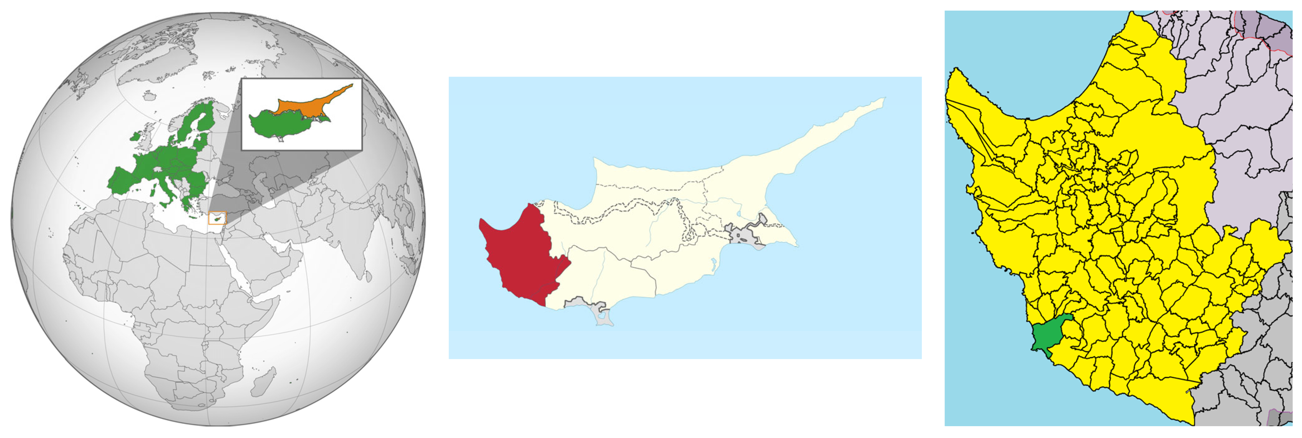
3.1. Study Area
3.2. Rationale and Logical Framework of the Study
3.3. Data Source
3.4. Implementation
4. Results
- (a)
- Building coverage factor, expressed as the maximum permissible building size in square meters relative to the plot area;
- (b)
- Area coverage factor, expressed as the maximum permissible ground level coverage of the plot in square meters relative to the plot area;
- (c)
- Maximum height factor, expressed as the tallest point the building can reach in meters).
5. Discussion
6. Conclusions
Author Contributions
Funding
Institutional Review Board Statement
Informed Consent Statement
Data Availability Statement
Acknowledgments
Conflicts of Interest
References
- Organisation for Economic Co-operation and Development-OECD. Rethinking Urban Sprawl: Moving towards Sustainable Cities; Organisation for Economic Co-operation and Development-OECD: Paris, France, 2018; ISBN 9789264189829. [Google Scholar]
- Lemonakis, C.; Alexopoulos, G.; Garefalakis, A.; Garefalakis, S. Trends and New Elements in Urban Hierarchy Research: The Greek Paradigm. Ann. Reg. Sci. 2023, 1–20. [Google Scholar] [CrossRef]
- Mitoula, R.; Gkagkosi, N. Sustainable Urban Resilience: Cities in the Face of Modern Challenges. In Case Study: The City of Elliniko-Argyroupoli, Greece, Proceedings of the 5th Symposium on Agri-Tech Economics for Sustainable Futures, Newport, UK, 19–20 September 2022; Paparas, D., Behrendt, K., Eds.; Global Institute for Agri-Tech Economics, Food, Land and Agribusiness Management Department, Harper Adams University: Newport, UK; HAU Publications: Newport, UK, 2022; pp. 45–63. ISBN 9781739818333. [Google Scholar]
- European Environment Agency. Urban Sprawl in Europe—The Ignored Challenge; Office for Official Publications of the European Communities: Copenhagen, Denmark, 2006; ISBN 92-9167-887-2. ISSN 1725-9177. [Google Scholar]
- Perrin, C.; Nougarèdes, B.; Sini, L.; Branduini, P.; Salvati, L. Governance Changes in Peri-Urban Farmland Protection Following Decentralisation: A Comparison between Montpellier (France) and Rome (Italy). Land Use Policy 2018, 70, 535–546. [Google Scholar] [CrossRef] [Green Version]
- Sadat Nickayin, S.; Bianchini, L.; Egidi, G.; Cividino, S.; Rontos, K.; Salvati, L. ‘Pulsing’ Cities and ‘Swarming’ Metropolises: A Simplified, Entropy-Based Approach to Long-Term Urban Development. Ecol. Indic. 2022, 136, 108605. [Google Scholar] [CrossRef]
- Cortinovis, C.; Haase, D.; Zanon, B.; Geneletti, D. Is Urban Spatial Development on the Right Track? Comparing Strategies and Trends in the European Union. Landsc. Urban Plan. 2019, 181, 22–37. [Google Scholar] [CrossRef]
- Salvati, L.; Carlucci, M. Patterns of Sprawl: The Socioeconomic and Territorial Profile of Dispersed Urban Areas in Italy. Reg. Stud. 2016, 50, 1346–1359. [Google Scholar] [CrossRef]
- Vinci, S.; Vardopoulos, I.; Salvati, L. A Tale of a Shrinking City? Exploring the Complex Interplay of Socio-Demographic Dynamics in the Recent Development of Attica, Greece. Cities 2023, 132, 104089. [Google Scholar] [CrossRef]
- Salvati, L.; Zambon, I.; Chelli, F.M.; Serra, P. Do Spatial Patterns of Urbanization and Land Consumption Reflect Different Socioeconomic Contexts in Europe? Sci. Total Environ. 2018, 625, 722–730. [Google Scholar] [CrossRef] [PubMed]
- Manika, S.; Karalidis, K.; Gospodini, A. Spatial Analysis of Economic Activities as a Tool for Effective Urban Policies. Smart Cities 2022, 5, 276–293. [Google Scholar] [CrossRef]
- López-Gay, A.; Andújar-Llosa, A.; Salvati, L. Residential Mobility, Gentrification and Neighborhood Change in Spanish Cities: A Post-Crisis Perspective. Spat. Demogr. 2020, 8, 351–378. [Google Scholar] [CrossRef]
- Egidi, G.; Zambon, I.; Tombolin, I.; Salvati, L.; Cividino, S.; Seifollahi-Aghmiuni, S.; Kalantari, Z. Unraveling Latent Aspects of Urban Expansion: Desertification Risk Reveals More. Int. J. Environ. Res. Public Health 2020, 17, 4001. [Google Scholar] [CrossRef]
- Tombolini, I.; Zambon, I.; Ippolito, A.; Grigoriadis, S.; Serra, P.; Salvati, L. Revisiting “Southern” Sprawl: Urban Growth, Socio-Spatial Structure and the Influence of Local Economic Contexts. Economies 2015, 3, 237–259. [Google Scholar] [CrossRef] [Green Version]
- Cervero, R.; Wu, K.-L. Polycentrism, Commuting, and Residential Location in the San Francisco Bay Area. Environ. Plan. A Econ. Space 1997, 29, 865–886. [Google Scholar] [CrossRef] [PubMed]
- Laidley, T. The Problem of Urban Sprawl. Contexts 2016, 15, 74–77. [Google Scholar] [CrossRef] [Green Version]
- Bosch, M.; Chenal, J.; Joost, S. Addressing Urban Sprawl from the Complexity Sciences. Urban Sci. 2019, 3, 60. [Google Scholar] [CrossRef] [Green Version]
- Seevarethnam, M.; Rusli, N.; Ling, G.H.T.; Said, I. A Geo-Spatial Analysis for Characterising Urban Sprawl Patterns in the Batticaloa Municipal Council, Sri Lanka. Land 2021, 10, 636. [Google Scholar] [CrossRef]
- Whyte, W.H.J. Urban Sprawl; Reprinted; Fortune: Baltimore, MD, USA, 1958. [Google Scholar]
- Smiraglia, D.; Salvati, L.; Egidi, G.; Salvia, R.; Giménez-Morera, A.; Halbac-Cotoara-Zamfir, R. Toward a New Urban Cycle? A Closer Look to Sprawl, Demographic Transitions and the Environment in Europe. Land 2021, 10, 127. [Google Scholar] [CrossRef]
- Egidi, G.; Halbac-Cotoara-Zamfir, R.; Cividino, S.; Quaranta, G.; Salvati, L.; Colantoni, A. Rural in Town: Traditional Agriculture, Population Trends, and Long-Term Urban Expansion in Metropolitan Rome. Land 2020, 9, 53. [Google Scholar] [CrossRef] [Green Version]
- Nickayin, S.S.; Salvati, L.; Coluzzi, R.; Lanfredi, M.; Halbac-Cotoara-Zamfir, R.; Salvia, R.; Quaranta, G.; Alhuseen, A.; Gaburova, L. What Happens in the City When Long-Term Urban Expansion and (Un)Sustainable Fringe Development Occur: The Case Study of Rome. ISPRS Int. J. Geo-Inf. 2021, 10, 231. [Google Scholar] [CrossRef]
- Escolano, J.J.; Pedreño, J.N.; Lucas, I.G.; Almendro Candel, M.B.; Zorpas, A.A. Decreased Organic Carbon Associated With Land Management in Mediterranean Environments. In Soil Management and Climate Change. Effects on Organic Carbon, Nitrogen Dynamics, and Greenhouse Gas Emissions; Muñoz, M.Á., Zornoza, R., Eds.; Academic Press Books-Elsevier: Cambridge, MA, USA, 2018; pp. 1–13. [Google Scholar]
- Rodríguez-Espinosa, T.; Navarro-Pedreño, J.; Gómez-Lucas, I.; Jordán-Vidal, M.M.; Bech-Borras, J.; Zorpas, A.A. Urban Areas, Human Health and Technosols for the Green Deal. Environ. Geochem. Health 2021, 43, 5065–5086. [Google Scholar] [CrossRef]
- Morelli, V.G.; Salvati, L. Ad Hoc Urban Sprawl in the Mediterranean City: Dispersing a Compact Tradition? Edizioni Nuova Cultura: Rome, Italy, 2010; ISBN 9788861345720. [Google Scholar]
- Cebrián Abellán, F.; Sánchez Ondoño, I. Urban Sprawl in Inner Medium-Sized Cities: The Behaviour in Some Spanish Cases Since the Beginning of the 21st Century. Urban Sci. 2019, 3, 10. [Google Scholar] [CrossRef] [Green Version]
- Artmann, M.; Inostroza, L.; Fan, P. Urban Sprawl, Compact Urban Development and Green Cities. How Much Do We Know, How Much Do We Agree? Ecol. Indic. 2019, 96, 3–9. [Google Scholar] [CrossRef]
- Fuladlu, K.; Riza, M.; Ilkan, M. Monitoring Urban Sprawl Using Time-Series Data: Famagusta Region of Northern Cyprus. SAGE Open 2021, 11, 215824402110074. [Google Scholar] [CrossRef]
- Chin, N. Unearthing the Roots of Urban Sprawl: A Critical Analysis of Form, Function and Methodology; CASA Working Papers 47; Centre for Advanced Spatial Analysis, UCL: London, UK, 2002. [Google Scholar]
- Sarzynski, A.; Galster, G.; Stack, L. Typologies of Sprawl: Investigating United States Metropolitan Land Use Patterns. Urban Geogr. 2014, 35, 48–70. [Google Scholar] [CrossRef]
- Cutsinger, J.; Galster, G. There Is No Sprawl Syndrome: A New Typology of Metropolitan Land Use Patterns. Urban Geogr. 2006, 27, 228–252. [Google Scholar] [CrossRef] [Green Version]
- Harvey, R.O.; Clark, W.A. V The Nature and Economics of Urban Sprawl. Land Econ. 1965, 41, 1–9. [Google Scholar] [CrossRef]
- Transportation Research Board. TCRP Report 39—The Costs of Sprawl—Revisited; National Academy Press: Washington, DC, USA, 1998. [Google Scholar]
- Brueckner, J.K. Urban Sprawl: Diagnosis and Remedies. Int. Reg. Sci. Rev. 2000, 23, 160–171. [Google Scholar] [CrossRef]
- Downs, A. Some Realities about Sprawl and Urban Decline. Hous. Policy Debate 1999, 10, 955–974. [Google Scholar] [CrossRef]
- Johnson, M.P. Environmental Impacts of Urban Sprawl: A Survey of the Literature and Proposed Research Agenda. Environ. Plan. A Econ. Sp. 2001, 33, 717–735. [Google Scholar] [CrossRef] [Green Version]
- Colantoni, A.; Grigoriadis, E.; Sateriano, A.; Venanzoni, G.; Salvati, L. Cities as Selective Land Predators? A Lesson on Urban Growth, Deregulated Planning and Sprawl Containment. Sci. Total Environ. 2016, 545–546, 329–339. [Google Scholar] [CrossRef]
- Ewing, R.H. Characteristics, Causes, and Effects of Sprawl: A Literature Review. In Urban Ecology; Marzluff, J.M., Shulenberger, E., Endlicher, W., Alberti, M., Bradley, G., Ryan, C., Simon, U., ZumBrunnen, C., Eds.; Springer: Boston, MA, USA, 2008; pp. 519–535. [Google Scholar]
- Razin, E.; Rosentraub, M. Are Fragmentation and Sprawl Interlinked? Urban Aff. Rev. 2000, 35, 821–836. [Google Scholar] [CrossRef]
- Burchfield, M.; Overman, H.G.; Puga, D.; Turner, M.A. Causes of Sprawl: A Portrait from Space. Q. J. Econ. 2006, 121, 587–633. [Google Scholar] [CrossRef] [Green Version]
- Bruegmann, R. Sprawl: A Compact History; University of Chicago Press: Chicago, IL, USA, 2005. [Google Scholar]
- Maier, G.; Franz, G.; Schrock, P. Urban Sprawl. How Useful Is This Concept? In Proceedings of the 46th Congress of the European Regional Science Association: “Enlargement, Southern Europe and the Mediterranean”, Volos, Greece, 30 August–3 September 2006; European Regional Science Association: Louvain-la-Neuve, Belgium, 2006. [Google Scholar]
- Lagarias, A.; Sayas, J. Is There a Common Typology of Urban Sprawl in Mediterranean Cities? Rev. d’Économie Régionale Urbaine 2019, 4, 813–850. [Google Scholar] [CrossRef]
- Dieleman, F.; Wegener, M. Compact City and Urban Sprawl. Built Environ. 2004, 30, 308–323. [Google Scholar] [CrossRef] [Green Version]
- Polyzos, S.; Minetos, D.; Niavis, S. Driving Factors and Empirical Analysis of Urban Sprawl in Greece. Theor. Empir. Res. Urban Manag. 2013, 8, 5–29. [Google Scholar]
- Burton, E. The Compact City: Just or Just Compact? A Preliminary Analysis. Urban Stud. 2000, 37, 1969–2006. [Google Scholar] [CrossRef]
- Shawly, H. Evaluating Compact City Model Implementation as a Sustainable Urban Development Tool to Control Urban Sprawl in the City of Jeddah. Sustainability 2022, 14, 13218. [Google Scholar] [CrossRef]
- Burgess, R. The Compact City Debate: A Global Perspective. In Compact Cities. Sustainable Urban Forms for Developing Countries; Burgess, R., Jenks, M., Eds.; Routledge: London, UK, 2000; p. 16. ISBN 9780203478622. [Google Scholar]
- Næss, P. Urban Planning and Sustainable Development. Eur. Plan. Stud. 2001, 9, 503–524. [Google Scholar] [CrossRef]
- Williams, K. Urban Intensification Policies in England: Problems and Contradictions. Land Use Policy 1999, 16, 167–178. [Google Scholar] [CrossRef]
- Salvati, L.; Sabbi, A. Identifying Urban Diffusion in Compact Cities through a Comparative Multivariate Procedure. Ann. Reg. Sci. 2014, 53, 557–575. [Google Scholar] [CrossRef]
- Banister, D. Unsustainable Transport City Transport in the New Century; Routledge: London, UK, 2005. [Google Scholar]
- Neyestani, B. A Proposed Sustainable Transportation and Urban Mobility Design. SSRN Electron. J. 2015, 1–21. [Google Scholar] [CrossRef]
- Neuman, M. The Compact City Fallacy. J. Plan. Educ. Res. 2005, 25, 11–26. [Google Scholar] [CrossRef] [Green Version]
- Rode, P. Governing Compact Cities: How to Connect Planning, Design and Transport; Edward Elgar: Cheltenham, UK, 2018. [Google Scholar]
- Burton, E.; Jenks, M.; Williams, K. (Eds.) The Compact City; Routledge: London, UK, 2003; ISBN 9781135816995. [Google Scholar]
- Bibri, S.E.; Krogstie, J.; Kärrholm, M. Compact City Planning and Development: Emerging Practices and Strategies for Achieving the Goals of Sustainability. Dev. Built Environ. 2020, 4, 100021. [Google Scholar] [CrossRef]
- Stevenson, M.; Thompson, J.; de Sá, T.H.; Ewing, R.; Mohan, D.; McClure, R.; Roberts, I.; Tiwari, G.; Giles-Corti, B.; Sun, X.; et al. Land Use, Transport, and Population Health: Estimating the Health Benefits of Compact Cities. Lancet 2016, 388, 2925–2935. [Google Scholar] [CrossRef] [Green Version]
- Holden, E.; Norland, I.T. Three Challenges for the Compact City as a Sustainable Urban Form: Household Consumption of Energy and Transport in Eight Residential Areas in the Greater Oslo Region. Urban Stud. 2005, 42, 2145–2166. [Google Scholar] [CrossRef]
- Bibri, S.E. Compact Urbanism and the Synergic Potential of Its Integration with Data-Driven Smart Urbanism: An Extensive Interdisciplinary Literature Review. Land Use Policy 2020, 97, 104703. [Google Scholar] [CrossRef]
- Cortesi, A.; Vardopoulos, I.; Salvati, L. A Partial Least Squares Analysis of the Perceived Impact of Sustainable Real Estate Design upon Wellbeing. Urban Sci. 2022, 6, 69. [Google Scholar] [CrossRef]
- Kempton, Y.; Salvati, L.; Vardopoulos, I. Long-Term Planning and Development for Urban and Regional Inclusion, Safety, Resilience, and Sustainability. Insights from Singapore. Reg. Peripher. 2022, 14, 59–79. [Google Scholar] [CrossRef]
- Vardopoulos, I.; Stamopoulos, C.; Chatzithanasis, G.; Michalakelis, C.; Giannouli, P.; Pastrapa, E. Considering Urban Development Paths and Processes on Account of Adaptive Reuse Projects. Buildings 2020, 10, 73. [Google Scholar] [CrossRef] [Green Version]
- Vardopoulos, I.; Papoui-Evangelou, M.; Nosovo, B.; Salvati, L. Smart ‘Tourist Cities’ Revisited: Culture-Led Urban Sustainability and the Global Real Estate Market. Sustainability 2023, 15, 4313. [Google Scholar] [CrossRef]
- Kyriakogkonas, P.; Garefalakis, A.; Pappa, E.; Kagias, P. Sustainable Project Management under the Light of ESG Criteria: A Theoretical Approach. Theor. Econ. Lett. 2022, 12, 1517–1538. [Google Scholar] [CrossRef]
- Voukkali, I.; Zorpas, A.A. Evaluation of Urban Metabolism Assessment Methods through SWOT Analysis and Analytical Hierocracy Process. Sci. Total Environ. 2022, 807, 150700. [Google Scholar] [CrossRef]
- Christensen, P.P. Historical Roots for Ecological Economics—Biophysical versus Allocative Approaches. Ecol. Econ. 1989, 1, 17–36. [Google Scholar] [CrossRef]
- Dovers, S.R. Sustainability: Demands on Policy. J. Public Policy 1996, 16, 303–318. [Google Scholar] [CrossRef]
- Vardopoulos, I. Industrial Building Adaptive Reuse for Museum. Factors Affecting Visitors’ Perceptions of the Sustainable Urban Development Potential. Build. Environ. 2022, 222, 109391. [Google Scholar] [CrossRef]
- Economou, A.; Mitoula, R. Sustainable Environment and Quality of Life in Coastal Urban Area of Vouliagmeni in Attica Region, Greece. Int. Rev. Soc. Sci. 2018, 6, 227–237. [Google Scholar]
- Zorpas, A.A. (Ed.) Sustainability behind Sustainability; Nova Science Publishers: Hauppauge, NY, USA, 2014; ISBN 9781633215733. [Google Scholar]
- Bai, X.; Surveyer, A.; Elmqvist, T.; Gatzweiler, F.W.; Güneralp, B.; Parnell, S.; Prieur-Richard, A.-H.; Shrivastava, P.; Siri, J.G.; Stafford-Smith, M.; et al. Defining and Advancing a Systems Approach for Sustainable Cities. Curr. Opin. Environ. Sustain. 2016, 23, 69–78. [Google Scholar] [CrossRef]
- Costa, M.S.; Silva, A.N.R.; Ramos, R.A.R. Sustainable Urban Mobility: A Comparative Study And The Basis For A Management System In Brazil And Portugal. In Urban Transport XI—Urban Transport and the Environment in the 21st Century; Brebbia, C.A., Wadhwa, L.C., Eds.; WIT Transactions on The Built Environment; WIT Press: Southampton, UK, 2005; Volume 77, pp. 323–332. [Google Scholar]
- Chavan, A.; Peralta, C.; Steins, C. (Eds.) Planetizen: Contemporary Debates in Urban Planning; Island Press: Washington, DC, USA, 2007. [Google Scholar]
- Salvati, L. A Long Way to Complexity: Nonlinear “Growth Stages” and Spatially Uncoordinated Settlement Expansion in a Compact City (Athens, Greece). Geogr. Anal. 2023, 55, 280–299. [Google Scholar] [CrossRef]
- Girardet, H. Creating Sustainable Cities; Green Books: New York, NY, USA, 2009. [Google Scholar]
- Sodiq, A.; Baloch, A.A.B.; Khan, S.A.; Sezer, N.; Mahmoud, S.; Jama, M.; Abdelaal, A. Towards Modern Sustainable Cities: Review of Sustainability Principles and Trends. J. Clean. Prod. 2019, 227, 972–1001. [Google Scholar] [CrossRef]
- Ciaschini, C.; Salvati, L. Enlarging Spatial Divides in Local Job Markets? Insights from Italy, 2004–2013. GeoJournal 2022, 87, 5087–5100. [Google Scholar] [CrossRef]
- Vardopoulos, I.; Tsilika, E.; Sarantakou, E.; Zorpas, A.A.; Salvati, L.; Tsartas, P. An Integrated SWOT-PESTLE-AHP Model Assessing Sustainability in Adaptive Reuse Projects. Appl. Sci. 2021, 11, 7134. [Google Scholar] [CrossRef]
- Salvati, L.; Morelli, V.G.; Rontos, K.; Sabbi, A. Latent Exurban Development: City Expansion Along the Rural-To-Urban Gradient in Growing and Declining Regions of Southern Europe. Urban Geogr. 2013, 34, 376–394. [Google Scholar] [CrossRef]
- Mitoula, R.; Astara, O.-E.; Kaldis, P. Βιώσιμη Aνάπτυξη: Έννοιες, Διεθνείς Και Ευρωπαϊκές Διαστάσεις; Rosili: Athens, Greece, 2008; ISBN 9608940727. [Google Scholar]
- Benassi, F.; Iglesias-Pascual, R.; Salvati, L. Residential Segregation and Social Diversification: Exploring Spatial Settlement Patterns of Foreign Population in Southern European Cities. Habitat Int. 2020, 101, 102200. [Google Scholar] [CrossRef]
- Doukas, Y.E.; Maravegias, N.; Chrysomallidis, C. Digitalization in the EU Agricultural Sector: Seeking a European Policy Response. In Food Policy Modelling Responses to Current Issues; Mattas, K., Baourakis, G., Zopounidis, C., Staboulis, C., Eds.; Springer: Cham, Germany, 2022; pp. 83–98. [Google Scholar]
- Mitoula, R.; Papavasileiou, A. Mega Infrastructure Projects and Their Contribution to Sustainable Development: The Case of the Athens Metro. Econ. Chang. Restruct. 2023, 56, 1943–1969. [Google Scholar] [CrossRef]
- Issaoui, M.; Jellali, S.; Zorpas, A.A.; Dutournie, P. Membrane Technology for Sustainable Water Resources Management: Challenges and Future Projections. Sustain. Chem. Pharm. 2022, 25, 100590. [Google Scholar] [CrossRef]
- Vardopoulos, I. Multi-Criteria Analysis for Energy Independence from Renewable Energy Sources Case Study Zakynthos Island, Greece. Int. J. Environ. Sci. Dev. 2017, 8, 460–465. [Google Scholar] [CrossRef] [Green Version]
- Vardopoulos, I.; Konstantopoulos, I.; Zorpas, A.A.; Bennici, S.; Inglezakis, V.; Voukkali, I. Sustainable Metropolitan Areas Perspectives through Assessment of the Existing Waste Management Strategies. Environ. Sci. Pollut. Res. 2020, 28, 24305–24320. [Google Scholar] [CrossRef] [PubMed]
- Vardopoulos, I.; Falireas, S.; Konstantopoulos, I.; Kaliora, E.; Theodoropoulou, E. Sustainability Assessment of the Agri-Environmental Practices in Greece. Indicators’ Comparative Study. Int. J. Agric. Resour. Gov. Ecol. 2018, 14, 368–399. [Google Scholar] [CrossRef]
- Salvati, L.; Carlucci, M. A Composite Index of Sustainable Development at the Local Scale: Italy as a Case Study. Ecol. Indic. 2014, 43, 162–171. [Google Scholar] [CrossRef]
- Ragazou, K.; Passas, I.; Garefalakis, A.; Zafeiriou, E.; Kyriakopoulos, G. The Determinants of the Environmental Performance of EU Financial Institutions: An Empirical Study with a GLM Model. Energies 2022, 15, 5325. [Google Scholar] [CrossRef]
- Zanganeh Shahraki, S.; Ahmadifard, N.; Farhadikhah, H.; Fotouhi Mehrabani, B.; Haydari, A.; Abdali, Y.; Abbasi Fallah, V.; Farhadi, E.; Cividino, S.; Vinci, S.; et al. Spatial Planning, Urban Governance and the Economic Context: The Case of ‘Mehr’ Housing Plan, Iran. Land 2020, 9, 169. [Google Scholar] [CrossRef]
- Vardopoulos, I. Adaptive Reuse for Sustainable Development and Land Use: A Multivariate Linear Regression Analysis Estimating Key Determinants of Public Perceptions. Heritage 2023, 6, 809–828. [Google Scholar] [CrossRef]
- Zakarya, Y.M.; Metwaly, M.M.; AbdelRahman, M.A.E.; Metwalli, M.R.; Koubouris, G. Optimized Land Use through Integrated Land Suitability and GIS Approach in West El-Minia Governorate, Upper Egypt. Sustainability 2021, 13, 12236. [Google Scholar] [CrossRef]
- D’Agata, A.; Quaranta, G.; Salvia, R.; Carlucci, M.; Salvati, L. Mixed Land Use as an Intrinsic Feature of Sprawl: A Short-Term Analysis of Settlement Growth and Population Distribution Using European Urban Atlas. Land 2023, 12, 972. [Google Scholar] [CrossRef]
- Di Feliciantonio, C.; Salvati, L.; Sarantakou, E.; Rontos, K. Class Diversification, Economic Growth and Urban Sprawl: Evidences from a Pre-Crisis European City. Qual. Quant. 2018, 52, 1501–1522. [Google Scholar] [CrossRef]
- Di Feliciantonio, C.; Salvati, L. ‘Southern’ Alternatives of Urban Diffusion: Investigating Settlement Characteristics and Socio-Economic Patterns in Three Mediterranean Regions. Tijdschr. Econ. Soc. Geogr. 2015, 106, 453–470. [Google Scholar] [CrossRef]
- Zitti, M.; Ferrara, C.; Perini, L.; Carlucci, M.; Salvati, L. Long-Term Urban Growth and Land Use Efficiency in Southern Europe: Implications for Sustainable Land Management. Sustainability 2015, 7, 3359–3385. [Google Scholar] [CrossRef] [Green Version]
- Duvernoy, I.; Zambon, I.; Sateriano, A.; Salvati, L. Pictures from the Other Side of the Fringe: Urban Growth and Peri-Urban Agriculture in a Post-Industrial City (Toulouse, France). J. Rural Stud. 2018, 57, 25–35. [Google Scholar] [CrossRef]
- Źróbek-Różańska, A.; Ogryzek, M.; Źróbek-Sokolnik, A. Creating a Healthy Environment for Children: GIS Tools for Improving the Quality of the Social Welfare Management System. Int. J. Environ. Res. Public Health 2022, 19, 7128. [Google Scholar] [CrossRef] [PubMed]
- Carballada, A.M.; Balsa-Barreiro, J. Geospatial Analysis and Mapping Strategies for Fine-Grained and Detailed COVID-19 Data with GIS. ISPRS Int. J. Geo-Inf. 2021, 10, 602. [Google Scholar] [CrossRef]
- Mújica, E.B.; Herdman, A.R.; Danaher, M.W.; González, E.H.; Zettler, L.W. Projected Status of the Ghost Orchid (Dendrophylax Lindenii) in Florida during the Next Decade Based on Temporal Dynamic Studies Spanning Six Years. Plants 2021, 10, 1579. [Google Scholar] [CrossRef] [PubMed]
- Silverman, B.W. Density Estimation for Statistics and Data Analysis; Chapman and Hall: New York, NY, USA, 2018. [Google Scholar]
- Kontoes, C.C.; Raptis, V.; Lautner, M.; Oberstadler, R. The Potential of Kernel Classification Techniques for Land Use Mapping in Urban Areas Using 5m-Spatial Resolution IRS-1C Imagery. Int. J. Remote Sens. 2000, 21, 3145–3151. [Google Scholar] [CrossRef]
- WELCH, R. Spatial Resolution Requirements for Urban Studies. Int. J. Remote Sens. 1982, 3, 139–146. [Google Scholar] [CrossRef]
- Dom, G.; Samochowiec, J.; Evans-Lacko, S.; Wahlbeck, K.; Van Hal, G.; McDaid, D. The Impact of the 2008 Economic Crisis on Substance Use Patterns in the Countries of the European Union. Int. J. Environ. Res. Public Health 2016, 13, 122. [Google Scholar] [CrossRef] [Green Version]
- Végh, M. Has Austerity Succeeded in Ameliorating the Economic Climate? The Cases of Ireland, Cyprus and Greece. Soc. Sci. 2014, 3, 288–307. [Google Scholar] [CrossRef] [Green Version]
- Sariannidis, N.; Garefalakis, A.; Ballas, P.; Grigoriou, E. Eco-Efficiency, Sustainable Development and Environmental Accounting in the Tourism Industry during a Crisis. Corp. Board Role Duties Compos. 2018, 14, 58–64. [Google Scholar] [CrossRef]
- Jim, C. Green-Space Preservation and Allocation for Sustainable Greening of Compact Cities. Cities 2004, 21, 311–320. [Google Scholar] [CrossRef]
- Zorpas, A.A.; Voukkali, I.; Loizia, P. The Impact of Tourist Sector in the Waste Management Plans. Desalin. Water Treat. 2015, 56, 1141–1149. [Google Scholar] [CrossRef]
- Zorpas, A.A.; Lasaridi, K.; Voukkali, I.; Loizia, P.; Inglezakis, V.J. Solid Waste from the Hospitality Industry in Cyprus. In Island Sustainability II, Proceedings of the 2nd International Conference on Island Sustainability, Brac, Croatia, 17–19 September 2012; Favro, S., Brebbia, C.A., Eds.; WIT Transactions on Ecology and the Environment; WIT Press: Southampton, UK, 2012; pp. 41–49. [Google Scholar]
- Salvati, L.; Morelli, V.G. Unveiling Urban Sprawl in the Mediterranean Region: Towards a Latent Urban Transformation? Int. J. Urban Reg. Res. 2014, 38, 1935–1953. [Google Scholar] [CrossRef]
- Tsiligiannis, A. Why Isn’t Urban Development Sustainable? J. Contemp. Urban Aff. 2020, 4, 71–78. [Google Scholar] [CrossRef] [Green Version]
- Pissourios, I. O Χωροταξικός Σχεδιασμός Στην Κύπρο: Iστορική Εξέλιξη Και Προοπτικές. In Κοινωνική, Ιστορική και Πολεοδομική Aνάλυση του Χώρου; Drakoulis, D.P., Tsotsos, G.P., Eds.; Stamoulis: Athens, Greece, 2014; pp. 465–480. [Google Scholar]
- Campbell, S. Green Cities, Growing Cities, Just Cities?: Urban Planning and the Contradictions of Sustainable Development. J. Am. Plan. Assoc. 1996, 62, 296–312. [Google Scholar] [CrossRef]
- Antrop, M. Landscape Change and the Urbanization Process in Europe. Landsc. Urban Plan. 2004, 67, 9–26. [Google Scholar] [CrossRef]
- Doukas, Y.E.; Maravegias, N.; Andreou, G. (Eds.) H Χωρική Διάσταση Της Ευρωπαϊκής Oλοκλήρωσης: Σύγκλιση ή Aπόκλιση; Dionicos: Athens, Greece, 2022. [Google Scholar]
- Cuadrado-Ciuraneta, S.; Durà-Guimerà, A.; Salvati, L. Not Only Tourism: Unravelling Suburbanization, Second-Home Expansion and “Rural” Sprawl in Catalonia, Spain. Urban Geogr. 2017, 38, 66–89. [Google Scholar] [CrossRef]
- Xie, Y.; Meng, X.; Cenci, J.; Zhang, J. Spatial Pattern and Formation Mechanism of Rural Tourism Resources in China: Evidence from 1470 National Leisure Villages. ISPRS Int. J. Geo-Inf. 2022, 11, 455. [Google Scholar] [CrossRef]
- Vardopoulos, I.; Theodoropoulou, E. Does the New ‘FIX’ Fit? Adaptive Building Reuse Affecting Local Sustainable Development: Preliminary Results. In Urban Heritage and the Modern City, Proceedings of the International Academic Forum (IAFOR) Conference on Heritage and the City (HCNY2018), New York, NY, USA, 7–9 November 2018; Official Conference Proceedings; International Academic Forum (IAFOR): Nagoya, Japan, 2018; pp. 97–114. [Google Scholar]
- Manola, M. Contribution of the Venetian Monuments of Rhodes to Cultural Tourism and the Local Development of the Island. Open J. Res. Econ. 2022, 5, 35–42. [Google Scholar] [CrossRef]
- Mitoula, R.; Theodoropoulou, E.; Karnabos, D.; Apostolopoulos, C.D. Contribution of Municipalities to the Cities’ Sustainable Physiognomy. Recording Local’s Opinions and Perceptions. The Case of Kallithea. Int. J. Sustain. Dev. Plan. 2012, 7, 345–355. [Google Scholar] [CrossRef]
- Sallustio, L.; Pettenella, D.; Merlini, P.; Romano, R.; Salvati, L.; Marchetti, M.; Corona, P. Assessing the Economic Marginality of Agricultural Lands in Italy to Support Land Use Planning. Land Use Policy 2018, 76, 526–534. [Google Scholar] [CrossRef]
- Panagiotopoulos, P.; Mitoula, R.; Georgitsoyanni, E.; Theodoropoulou, E. The Contribution of Sports Tourism to Sustainable Development Based on Sustainable Development Indicators—The Case of Greece. Int. J. Multidiscip. Res. Anal. 2022, 5, 1666–1678. [Google Scholar] [CrossRef]
- Mitoula, R.; Stathoulopoulos, T.; Genitsaropoulos, C. Die Regional Universitäten und Deren Beitrag zur Wirtschaftlichen Entwicklung der Region. Der Fall von Livadia in Griechenland. Zeitschrift für die Reg. Wiss.-Hell. Verband der Reg. Wissenschaftler 2014, 5, 71–79. [Google Scholar]
- Doukas, Y.E. Economic Activity and Productivity: The Role of Density in the Greek Urban Space. In Proceedings of the European Association of Geographers Annual Meeting “Geography: Your World—A European Perspective”, Athens, Greece, 2–5 June 2011; National and Kapodistrian University of Athens: Athens, Greece, 2011. [Google Scholar]
- Ye, Y.; Li, D.; Liu, X. How Block Density and Typology Affect Urban Vitality: An Exploratory Analysis in Shenzhen, China. Urban Geogr. 2018, 39, 631–652. [Google Scholar] [CrossRef]
- Duranton, G.; Puga, D. The Economics of Urban Density. Econ. Perspect. 2020, 34, 3–26. [Google Scholar] [CrossRef]
- Salvati, L.; Sateriano, A.; Bajocco, S. To Grow or to Sprawl? Land Cover Relationships in a Mediterranean City Region and Implications for Land Use Management. Cities 2013, 30, 113–121. [Google Scholar] [CrossRef]
- Karaveli, E.; Doukas, Y.E. Rural Development Policy: An Alternative Development Strategy for Τhe Case of Greece. Reg. Peripher. 2012, 21–36. [Google Scholar] [CrossRef]
- Papamichael, I.; Voukkali, I.; Zorpas, A.A. Mediterranean: Main Environmental Issues and Concerns. Euro-Mediterranean J. Environ. Integr. 2022, 7, 477–481. [Google Scholar] [CrossRef]
- Zhang, J.; Cenci, J.; Becue, V.; Koutra, S. Analysis of Spatial Structure and Influencing Factors of the Distribution of National Industrial Heritage Sites in China Based on Mathematical Calculations. Environ. Sci. Pollut. Res. 2022, 29, 27124–27139. [Google Scholar] [CrossRef]
- Wang, X.; Zhang, J.; Cenci, J.; Becue, V. Spatial Distribution Characteristics and Influencing Factors of the World Architectural Heritage. Heritage 2021, 4, 2942–2959. [Google Scholar] [CrossRef]


| Indicator | Description |
|---|---|
| Average population density | The average number of inhabitants in a km2 of land, urban area |
| Population-to-density allocation | The share of population living in areas where population density is below a certain threshold (e.g., 1500 inhabitants/km2) |
| Land-to-density allocation | The share of urban footprint of areas where population density lies below a certain threshold (e.g., 1500 inhabitants/km2) |
| Variation of population density | The degree to which population density varies across the city |
| Fragmentation | The number fragments of urban fabric per km2 of built-up area |
| Polycentricity | The number of high-density peaks in an urban area |
| Decentralization | The percentage of population residing outside the high-density peaks of an urban area |
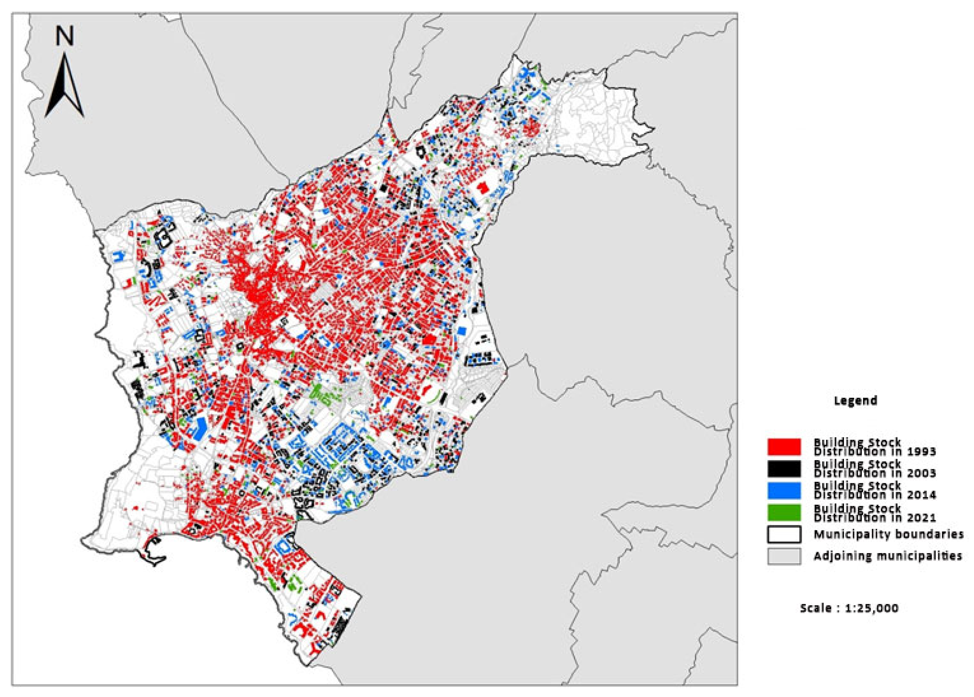
| 1993 Pafos analog map |
| 1993 Pafos orthophoto maps (Figure 2) |
| 1993 Pafos Local Plan (Figure 3) |
| 2003 Pafos Local Plan (Figure 4) |
| 2009 Pafos satellite images (Google Earth) (Figure 5) |
| 2014 Pafos high-resolution orthophoto maps (Figure 6) |
| 2021 Pafos Satellite Images (via Google Earth) |
| Shapefile map (administrative boundaries, buildings, land plots, and zoning derived from 2014 (Figure 7) and 2019 Pafos Local Plans) |
| Pafos Municipality | Building Stock Distribution in 1993 | Building Stock Distribution in 2003 | Building Stock Distribution in 2014 | Building Stock Distribution in 2021 |  | |
| land area (km2) | 16.93 | 1.46 | 1.88 | 2.3 | 2.4 | |
| proportion within Pafos (%) | 8.60 | 11 | 13.60 | 14.10 | ||
| % change (1993–2021) | 64.40% | |||||
| 1993 | % | 2003 | % | 2014 | % | 2021 | % | |
|---|---|---|---|---|---|---|---|---|
| Urban commercial center (km2) | 0.53 | 3.1 | 0.36 | 2.1 | 0.49 | 2.9 | 0.47 | 2.8 |
| Residential areas | 9.36 | 55.3 | 9.99 | 59 | 9.57 | 56.5 | 9.57 | 56.5 |
| Core areas and continuous development zones | 0.46 | 2.7 | 0.44 | 2.6 | 0.48 | 2.8 | 0.48 | 2.8 |
| Commercial activities outside the urban commercial center | 1.38 | 8.2 | 1.35 | 8 | 1.62 | 9.6 | 1.62 | 9.6 |
| Public buildings | 0.26 | 1.5 | 0.6 | 3.5 | 0.6 | 3.5 | 0.6 | 3.5 |
| Tourist zones | 1.7 | 10 | 1.63 | 9.6 | 1.65 | 9.8 | 1.64 | 9.7 |
| Industrial zones | 0.21 | 1.2 | 0.26 | 1.5 | 0.23 | 1.4 | 0.23 | 1.4 |
| Rural zones | 2.16 | 12.8 | 2.3 | 13.6 | 2.29 | 13.5 | 2.29 | 13.5 |
| Agricultural zones | 0.87 | 5.1 | - | 0.0 | - | 0.0 | 0.036 | 0.2 |
| Total | 16.93 | 100 | 16.93 | 100 | 16.93 | 100 | 16.93 | 100 |
Disclaimer/Publisher’s Note: The statements, opinions and data contained in all publications are solely those of the individual author(s) and contributor(s) and not of MDPI and/or the editor(s). MDPI and/or the editor(s) disclaim responsibility for any injury to people or property resulting from any ideas, methods, instructions or products referred to in the content. |
© 2023 by the authors. Licensee MDPI, Basel, Switzerland. This article is an open access article distributed under the terms and conditions of the Creative Commons Attribution (CC BY) license (https://creativecommons.org/licenses/by/4.0/).
Share and Cite
Vardopoulos, I.; Ioannides, S.; Georgiou, M.; Voukkali, I.; Salvati, L.; Doukas, Y.E. Shaping Sustainable Cities: A Long-Term GIS-Emanated Spatial Analysis of Settlement Growth and Planning in a Coastal Mediterranean European City. Sustainability 2023, 15, 11202. https://doi.org/10.3390/su151411202
Vardopoulos I, Ioannides S, Georgiou M, Voukkali I, Salvati L, Doukas YE. Shaping Sustainable Cities: A Long-Term GIS-Emanated Spatial Analysis of Settlement Growth and Planning in a Coastal Mediterranean European City. Sustainability. 2023; 15(14):11202. https://doi.org/10.3390/su151411202
Chicago/Turabian StyleVardopoulos, Ioannis, Sophia Ioannides, Marios Georgiou, Irene Voukkali, Luca Salvati, and Yannis E. Doukas. 2023. "Shaping Sustainable Cities: A Long-Term GIS-Emanated Spatial Analysis of Settlement Growth and Planning in a Coastal Mediterranean European City" Sustainability 15, no. 14: 11202. https://doi.org/10.3390/su151411202