Article

Examining Spatial Inequalities in Public Green Space Accessibility: A Focus on Disadvantaged Groups in England

1
College of Art and Design, Nanjing Forestry University, Nanjing 210037, China
2
School of Geography, University of Leeds, Leeds LS2 9JT, UK
*
Author to whom correspondence should be addressed.
These authors contributed equally to this work.
Sustainability 2023, 15(18), 13507; https://doi.org/10.3390/su151813507
Submission received: 1 August 2023 / Revised: 3 September 2023 / Accepted: 6 September 2023 / Published: 9 September 2023

Abstract

:
Green spaces have been recognised for their positive impact on residents’ health and well-being. However, equitable access to these spaces remains a concern as certain social groups face barriers to reaching public green areas (PGS). Existing studies have explored the relationship between green spaces and vulnerable populations but have often overlooked the spatial variations in accessibility experienced by these groups. This research aimed to investigate the spatial association between green space accessibility and five key variables representing vulnerability: age, educational deprivation, health deprivation, crime rates, and housing barriers. Ordinary least squares and multi-scale geographically weighted regression (MGWR) techniques were employed to analyse the relationship between the nearest distance to public green spaces and the challenges experienced by vulnerable groups based on socioeconomic factors in England. The findings highlight disparities in open green space access for vulnerable groups, particularly older adults and individuals with limited education and housing accessibility, who are more likely to face restricted access to green spaces. There was a negative correlation found between health deprivation and the accessibility of green spaces, indicating people who suffer from the disease may live closer to green spaces. Surprisingly, although a positive association was observed between crime risk and distance to public green space in most areas, there were specific areas that exhibit a negative correlation between them. This study emphasises the importance of considering the perspectives of vulnerable groups in addressing PGS inequality and underscores the need for inclusive public green space planning and policy development.

1. Introduction

1.1. Public Green Space and Human Well-Being

The effects of green spaces in promoting resident health and sustainable local development have gained attention in recent studies [1,2,3,4,5,6,7,8,9,10]. Previous research has demonstrated that the diverse and substantial health benefits associated with public green spaces (PGS), encompassing improvements in both physical and mental well-being [4,5] as well as reductions in morbidity and mortality rates [6]. Moreover, empirical evidence indicates an inverse relationship between green spaces and the prevalence of certain diseases, including respiratory illnesses, cardiovascular disorders, obesity, and other related conditions [1,7,8,9,10]. In addition to their health-related benefits, PGS contributes to the sustainable development of local environments through the facilitation of community integration [2].

1.2. Green Space Accessibility for Disadvantaged Groups

In previous studies, vulnerable groups mostly included older adults, low-income populations, and those with a higher prevalence of specific diseases compared to non-vulnerable populations [11]. These groups often face challenges from factors such as poverty, limited education, inadequate healthcare access, and exposure to environmental hazards [12,13,14]. Existing studies have demonstrated that disadvantaged groups have less access to public green spaces compared to non-disadvantaged groups, and this happens in both developed countries (Global North) [12] and developing countries (Global South) [15]. Disadvantaged groups may have a more pressing need for green spaces to achieve comparable levels of social well-being as non-disadvantaged groups. Environmental justice research has shown that areas with more green spaces exhibit lower rates of mortality and cardiovascular disease, suggesting that open green spaces provide significant benefits to disadvantaged areas [16]. Moreover, evidence suggests that individuals with lower socioeconomic status enjoy lower benefits from green spaces compared to wealthier groups [17]. This socio-spatial inequality may be attributed to the resource and capacity advantages enjoyed by non-disadvantaged groups, enabling them to access and benefit from public green spaces more effectively, even when the equal status of green spaces is provided to both disadvantaged and non-disadvantaged groups in a given location [15]. While existing studies examining green spaces for disadvantaged groups have focused on differences in socioeconomic variables, it is crucial to recognise that these groups do not experience equal green space accessibility as non-disadvantaged groups. Thus, it is necessary to explore the relationship between public green spaces and vulnerable socioeconomic variables specifically for disadvantaged groups, thereby investigating green space allocation for future local development.

1.3. Public Green Space Inequality

National green space indicators differ significantly between cultures [17,18,19,20,21,22]. For instance, the European Environment Agency (EEA) recommends that residents should have access to a green space within a one-kilometre radius, equivalent to approximately a 15 min walk [23]. The Trust for Public Land in the United States employs an 800 m walking distance from a park as a criterion for assessing park accessibility [24]. In China, park coverage is a primary factor considered in the evaluation of green spaces within open green space regulations for residential land use [25]. The UK advises that residents should have green spaces within a 300 m proximity to their residences [26,27]. While some scholars focus on examining the disparities in green space accessibility, quantity, and quality to identify environmental inequalities [12,28,29,30,31,32,33], fewer studies have addressed the variations in green space access among different disadvantaged groups. Furthermore, achieving sustainable local development requires addressing the mismatch between the supply and demand for green space and balancing the needs of diverse stakeholders [34]. Currently, there is a lack of research discussing the distinct needs of different social groups for green space. It is essential to investigate open green space in alignment with the needs of disadvantaged groups, thus exploring the inequality in access to green space.
However, equitable access to green spaces and the associated social benefits are not uniform among residents and communities [12,35]. The determinants of equitable access to public greenery are multifaceted. For example, the utilisation of green spaces is influenced by levels of social integration [36]. Moreover, access to green spaces can be influenced by socioeconomic status and the extent of poverty within neighbourhoods [37,38]. At the individual level, household income has been found to be correlated with the availability of green space [39]. Additionally, when considering cities with populations exceeding one million, variations in educational attainment among individuals are associated with differences in accessible green spaces in residential areas [38]. While numerous studies have explored PGS equity within different political, economic, and demographic contexts, the focus has been predominantly on entire social groups, neglecting a comprehensive examination of PGS equity disparities specifically among disadvantaged groups. The visible inequality in access to public green spaces is particularly pronounced among disadvantaged groups. Therefore, it is imperative to examine PGS inequality by specifically focusing on vulnerable groups and excluding non-vulnerable groups from the analysis.

1.4. Research Gap

Through a comprehensive literature analysis, we identified several gaps and limitations in existing research on public green space (PGS) inequality. Firstly, previous studies have primarily focused on comparing PGS inequalities between vulnerable and non-vulnerable groups, neglecting a more in-depth examination of the specific variations within vulnerable groups, particularly concerning the interactions between different vulnerability factors. Existing research has focused on which factors influence inequalities in public green space [12,13,14,15,18,19], but how each socioeconomic variable of disadvantaged groups is influenced by the allocation of green space is not considered in most studies. Comparing different socioeconomic variables of deprivation can understand which disadvantaged groups face the most serious green space inequality, further promoting environmental justice. To address this research gap, our study aims to establish a robust link between five key factors (age, education, health, crime rate, and housing barrier) which significantly impact vulnerable groups and their access to green spaces.
Secondly, the existing literature has predominantly emphasised evaluating PGS accessibility through factors such as per capita area and travel time to ensure equitable distribution of local public services [12]. However, for vulnerable groups, the paramount concern is whether they have access to nearby green spaces, prioritising proximity over the size or quality of these spaces. Therefore, considering the sensitivity of vulnerable groups to their environment, the distance to green spaces becomes a critical factor to explore. Consequently, our study adopts the distance to the nearest green space as an independent variable to investigate the association between vulnerable groups and PGS inequality.
Furthermore, the emergence of advanced spatial geographic regression techniques offers an opportunity to gain deeper insights into the relationship between vulnerable groups and green spaces at different spatial scales. Considering spatial heterogeneity and analysing inequality across various regions can provide valuable insights into the complex spatial relationships between PGS and diverse socioeconomic statuses. The application of multi-scale geographically weighted regression (MGWR) enables the identification of significant inequality phenomena at the local level, capturing the spatial variations of neighbourhood greenery and related socioeconomic variables [40]. Notably, MGWR has demonstrated superior results and explanatory power compared to traditional geographically weighted regression (GWR) models in recent studies [40,41,42,43]. Therefore, we employed the MGWR model in our research to effectively explore the spatial association between vulnerable groups and PGS inequality.
By building upon the identified research gaps, our study endeavours to examine the intricate relationship between PGS and key variables within vulnerable groups, thereby providing a more precise analysis of their access to green spaces. Utilising ordinary least squares and MGWR models, we analysed the spatial distribution characteristics of PGS inequality and socioeconomic variables in England, while simultaneously investigating the association between vulnerable groups and PGS inequality. Given England’s particular emphasis on the link between green spaces and well-being, along with its attention to health issues, it offers an ideal case study area for PGS research, especially concerning vulnerable groups [44,45,46]. Moreover, previous empirical studies on the accessibility of local public services in the UK have already revealed spatial disparities [45,46]. Our research findings are expected to provide valuable theoretical support for future PGS planning and design initiatives aimed at promoting social inclusivity. Additionally, we aim to propose appropriate strategies to address inequalities faced by vulnerable groups in relation to local planning and contribute to the advancement of sustainable development in local environments.

2. Data and Methods

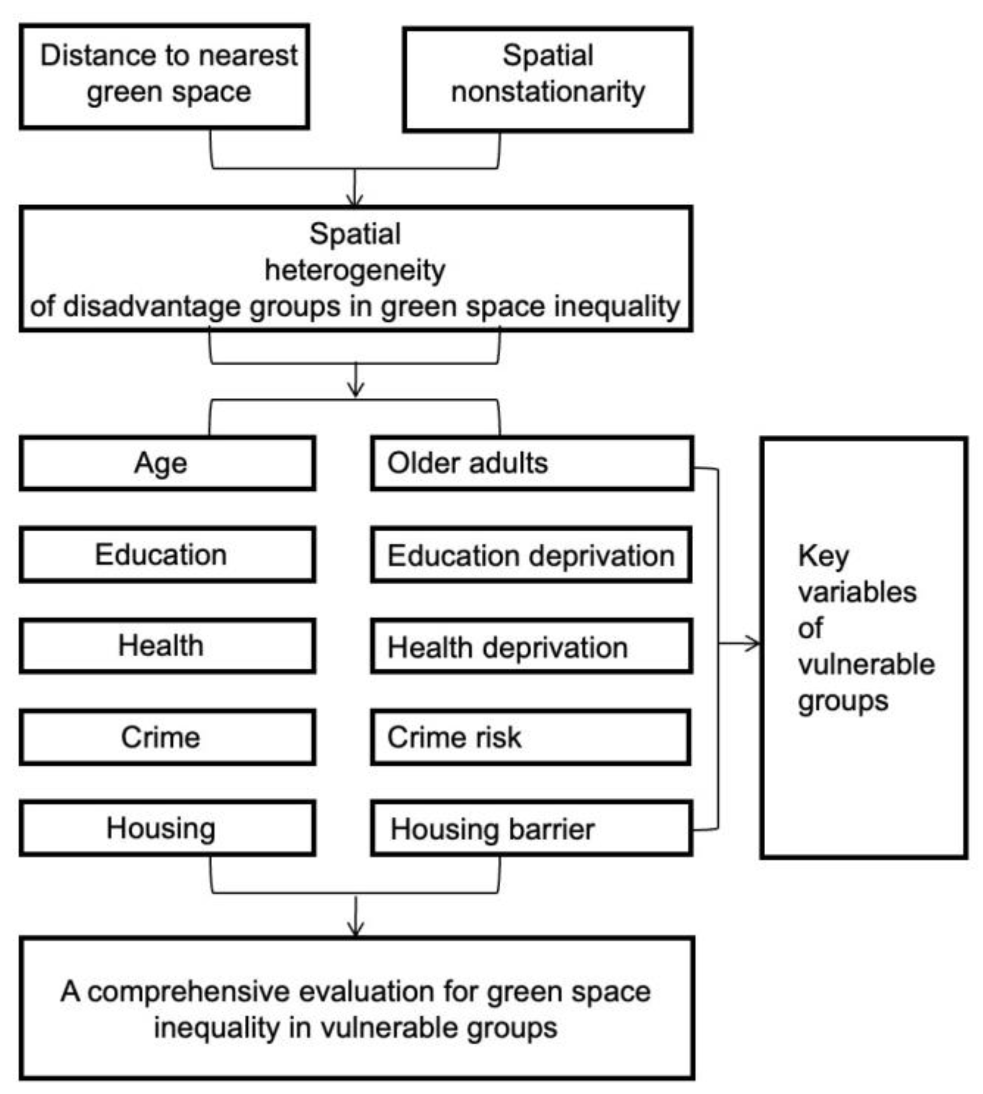
2.1. Theoretical Framework

The theoretical framework presented in Figure 1 illustrates our approach to exploring public green space inequality. Specifically, our research endeavours to investigate the relationship between the distance to the nearest green space and various disadvantaged groups. It is important to acknowledge that environmental factors can impact green space areas differently, leading to spatial non-smoothness in the relationships [47,48]. To address this complexity, we undertook the analysis by considering spatial non-stationarity, allowing us to comprehend the extent of disparities among different disadvantaged groups. To comprehensively assess green space inequality, we focused on five key socio-economic variables of deprivation, namely, age, education, health, crime rates, and housing barriers. By examining the interplay between these variables and the proximity to the nearest green space, we gained insights into the specific variations experienced by different disadvantaged groups.

2.2. Study Area

For our study conducted in England, we utilised land use data obtained from two geographical units: middle layer super output areas (MSOAs) and local super output areas (LSOAs). MSOAs, characterised by a minimum population of 5000 and an average population of 7200, are suitable for capturing the local environment accurately. In England, there are a total of 6780 MSOAs. To assess the relative poverty levels in higher-level administrative regions such as local authority districts, data at the LSOA level were often aggregated. The study area encompassed nine administrative regions, namely, Greater London, Northeast England, Northwest England, Yorkshire and the Humber, West Midlands, East Midlands, East England, Southwest England, and Southeast England. The total land area of the nation under consideration amounted to 130,279 km2.

2.3. Inequality of Green Space

While some studies have proposed remote-sensing-based approaches to evaluate the spatial distribution of green spaces within communities, the majority of these studies rely on quantitative measurements. These measurements typically involve assessing factors such as the green space area per resident or the percentage of green space coverage [49,50,51]. However, in addition to quantity, the accessibility of green spaces significantly impacts residents and is therefore considered a crucial attribute for assessing green space. Although satellite images provide a bird’s eye view, may not necessarily align with people’s ground-level perspective of green spaces [52,53]. Disadvantaged groups, in particular, may place greater importance on easy access to green spaces [17]. Therefore, this study primarily focuses on examining the accessibility of green spaces through the measurement of distances, as it serves as a fundamental component for assessing equity in green space distribution [54]. The comparative analysis of distance variations across different scales is a central aspect of this study.
We focused our research on publicly accessible green spaces, offering greater accessibility and better infrastructure amenities compared to natural green spaces. Public green spaces generally have higher levels of safety and better accessibility features (infrastructure, green space maintenance, road safety, restrooms, etc.), which have been shown to be needed by disadvantaged groups [55,56]. These spaces are particularly significant for disadvantaged groups and can address potential disparities in environmental accessibility. Therefore, studying publicly accessible green spaces can effectively investigate the issue of environmental equity faced by disadvantaged groups. Data sourced from the Office for National Statistics report titled “How has lockdown changed our relationship with nature?” underpins the investigation into new public green spaces introduced in the UK in 2021 [57]. Within this report, diverse green space categories such as public gardens, national forests, campgrounds, and other outdoor areas are delineated. Analysis of the frequency of local visits to these spaces draws from historical insights gleaned from the Monitoring of Natural Environment Engagement (MENE) survey, which specifically focuses on England.
Geographical proximity to the nearest green space was ascertained using urban zip codes, in alignment with data from Google Mobile [49]. To extrapolate findings from zip code-level data to broader geographic scales, population data at the local super output area (LSOA) level, derived from the 2011 Census, were leveraged. Additionally, estimations regarding average green space areas for individual zip code units were derived based on aggregations at the MSOA level [57]. This multifaceted approach, encompassing geographical, demographic, and historical dimensions, ensured a comprehensive understanding of the distribution, accessibility, and utilisation of publicly accessible green spaces in the UK.

2.4. Variables

Previous research has extensively investigated the link between socio-demographic and economic characteristics and green space distribution in various cities, revealing differential levels of green space exposure among residents based on age, education, and health status [36,38,58]. Building on these findings, we considered these variables as critical factors in examining green space inequality among disadvantaged groups in our study. In addition to income, poverty can be encompassed by a lack of access to essential resources beyond financial means [59,60]. Consequently, our study incorporated other aspects of vulnerability, such as crime rates and housing barriers, which can indirectly influence income status. Furthermore, certain studies have taken population density, floor area, and household size into account as socio-economic variables, potentially influencing the assessment of the green space relationship [61,62,63]. To address this aspect, we also included population density, built-up area, and household size as control variables in our model. These variables serve to control for potential confounding effects and contribute to a more nuanced understanding of the intricate relationship between green space accessibility and socio-economic characteristics within disadvantaged groups. By considering a comprehensive range of variables, our study provides a robust analytical approach to investigating green space inequality among vulnerable populations.
The socio-economic data used in this study were obtained from the Index of Deprivation in the UK 2019 (IoD 2019) [59]. The Department of Housing, Communities and Local Government, along with its predecessors, has utilised the Index of Deprivation since the 1970s to assess local levels of deprivation in England, which provides valuable socio-economic information. The IoD 2019 serves as a recently updated version of the UK Deprivation Index for 2015. The small geographical units referred to as lower level super output areas (LSOAs), which amount to 32,844 neighbourhoods in England, are employed by the UK Index of Deprivation (UKID) to measure relative disadvantage at a local level. The reason for selecting the UK deprivation index is its comprehensive data coverage, which includes specific aspects for measuring poverty. Based on this information, a selection of seven variables was made to capture various socioeconomic aspects: age, education, health, crime rate, housing barrier, population density, built-up area, and household size. Variables such as age, education, health, and crime rate are considered variables, while population density, built-up area, and household size serve as control variances. Specifically, the age group of seniors aged 70 or above was chosen as one of the age-related variables. The educational deprivation category reflects both low achievement and skill levels within the local population. This category comprises two sub-domains, one focusing on skills among children and young individuals, and the other assessing abilities among adults. These sub-domains aim to represent the existing educational disparities within a region. Regarding health deprivation, the selected variables encompass physical and mental illness, including disabilities. Health deprivation evaluates the risk of premature mortality and reduced quality of life associated with such conditions. It is important to note that this area of measurement does not account for environmental factors that may predict future health status but rather focuses on sickness, disability, and premature mortality. The crime rate serves as an indicator of the local risk of bodily harm and material damage. Housing barrier captures both the physical and economic aspects of accessing housing services and the barriers individuals may face. This indicator comprises two sub-domains: geographical barriers, which relate to the physical distance to local services, and “wider barriers”, which encompass issues related to housing affordability and access [61]. The UK Deprivation Index adheres to a well-established scientific framework and employs a comprehensive definition of deprivation that accounts for diverse individual living situations.
Table 1 presents the descriptive analysis of all variables used in this study. The average distance to the nearest public green space in England was found to be 4.24 km, which is a quite long distance for people to go on foot, especially for older adults. The relatively high rate of housing services and barriers (mean = 21.87, S.D. = 8.68) suggests that a significant portion of the residents face challenges in accessing adequate housing facilities. In terms of educational resources, the results indicate a similarly high rate of limited knowledge and skills among the local population (mean = 21.60, S.D. = 15.87), suggesting that a substantial portion of the population lacks access to quality education and the ability to acquire essential skills that can contribute to income improvement. Regarding age, the mean value of the local population as a percentage of the total population aged 70 years and above was found to be approximately 0.14, indicating that the older population constitutes a relatively small proportion of the deprived population. The relatively lower rate of health deprivation (mean = −0.12, S.D = 0.77) suggests that the majority of the population has passable quality physical and mental health status. On the crime rate, the results imply a similarly low rate of crime risk (mean = −0.01, S.D. = 0.70), suggesting that a small percentage of the population experiences the risk of personal and material victimisation at the local level.

2.5. Statistical Analysis

The statistical analysis for this study employed two models: ordinary least squares (OLS) and multiscale geographically weighted regression (MGWR). To investigate the geographic dynamics of public green space distribution, OLS was used to model spatial relationships. OLS is a widely used method in studies that allows for the prediction of the relationship between explanatory and dependent variables within a geographic information system (GIS) framework [64,65]. However, the limitation of OLS is its assumption of spatial smoothness, which overlooks spatial heterogeneity and may restrict its descriptive and predictive capabilities [66]. To address this limitation, MGWR was employed in this study, which accounts for spatial heterogeneity by calibrating a multiple regression model that allows for varying associations across different spatial locations to capture spatial variation [67]. While traditional GWR considers a single bandwidth for all parameters at a single spatial scale, the use of multiple bandwidths across parameter surfaces offers a more accurate and practical representation of the real world [68]. Therefore, in this study, both OLS and MGWR were applied to examine the spatial relationship between the distance to the nearest green space and vulnerable groups within the region.

2.5.1. Ordinary Least Squares (OLS)

All statistical analyses were conducted using ArcGIS 10.8, specifically ArcMap 10.8, for processing spatial data. To examine the relationship between disadvantaged groups and the nearest green space, ordinary least squares (OLS) was employed in this study as a widely recognised multivariate analysis method. OLS enables the prediction of values for a continuous response variable by utilising one or more explanatory variables. Additionally, it determines the strength of the relationships between these variables [69]. The following formula represents how OLS performed:
y i = β 0 + β 1 x i 1 + β 2 x i 2 + + β p x i p + ϵ ,
In Equation (1), y i represents the dependent variable under investigation; x i 1 corresponds to the independent variables in the model; β 0 denotes the intercept or constant term in the equation; β p represents the slope coefficients associated with each of the independent variables; and ∈ refers to the error term or residuals in the model, signifying the unexplained variability that remains after accounting for the relationship between the dependent and independent variables.
To examine the presence of multicollinearity among the explanatory variables, an evaluation was conducted to determine if there was a moderate or high level of interdependence. This assessment was accomplished by calculating the variance inflation factor (VIF) for each variable. VIF quantifies the extent of dependence among the independent variables and measures the inflation in the variance of the estimated regression coefficients [70].

2.5.2. Multiscale Geographically Weighted Regression (MGWR)

Geographically weighted regression (GWR) is a methodology used to investigate relationships that exhibit spatial variations and provide localised regression results. Unlike global regression approaches, GWR generates local coefficients by assigning greater weights to nearby observations, taking into account the geographical location of the county centroid. GWR is valuable in addressing the spatial non-stationarity of the relationship between the response variable and explanatory variables. Typically, the observed values of each covariate exhibit fluctuations at various spatial scales, but conventional GWR employs fixed bandwidths for all explanatory variables, oversimplifying these processes. To overcome this limitation, multiscale geographically weighted regression (MGWR) incorporates a back-fitting approach based on the general additive model (GAM). MGWR allows for the estimation of separate optimal bandwidths for each explanatory variable, accommodating the varying spatial scales of the underlying processes [67]. The equation for MGWR is listed as follows:
y i = j = 1 k β bwj μ i , υ i x ij + ε i ,
where y i indicates the distance to the nearest green space at unit i , x i j is the jth predictor variable of unit i , and β bwj μ i , υ i denotes the coefficient of unit i for location μ i , υ i , in which bwj represents the i th optimal bandwidth.

3. Results

3.1. Spatial Pattern of Public Green Space Accessibility in England

Figure 2 illustrates the spatial pattern of accessibility of public green spaces across the UK. It reveals that regions in the Northeast, Northwest, West, and Southwest generally exhibit longer distances to green spaces, ranging from approximately 17.038 to 35.419 km. These results may be influenced by the geographical location, as studies have shown that different topography may affect the accessibility of green space [71]. Specific examples are the highlands in the West Midlands, North East, and North West, and Yorkshire and the Humber in England, with heights of around 610 m and 315 m respectively. In contrast, metropolitan areas, such as Greater London, Greater Manchester, and Yorkshire, show the closest proximity to green spaces, with distances ranging from 0.974 to 3.477 km. This can be attributed to London’s abundant and diverse green spaces, as it has been designated a “National Park City” with approximately 41% of its area covered by green spaces [72]. Furthermore, the distribution of green spaces may be influenced by the level of local economic growth, as investments in afforestation projects often correlate with household income and per capita gross domestic product (GDP), reflecting the economic development of areas [43]. For instance, Newcastle-upon-Tyne and Gateshead in the northern part of England are located relatively closer to green spaces. Gateshead, which has experienced greater industrial growth, and Newcastle, known for its educational and cultural industries, both exhibit a certain degree of economic development [73]. Bristol, recognised as a “Green City” and awarded the title of European Green Capital in 2015, exemplifies the focus on promoting sustainability and environmental initiatives [74].

3.2. The Results of the Ordinary Linear Square Model

Table 2 presents the results of the ordinary least squares (OLS) model. The assessment of multicollinearity using variance inflation factor (VIF) revealed no significant collinearity issues, as all VIF values were below 3, except for the health deprivation variable. The results indicated that age exhibited a significant positive correlation with public green space (PGS) exposure, with the highest coefficient of 7.269 among all variables and a standard error (SE) of 0.774. Educational deprivation (Coef = 0.012; SE = 0.003), health deprivation (Coef = 0.254; SE = 0.059), and housing accessibility barriers (Coef = 0.110; SE = 0.005) were positively associated with PGS distance, while crime rate exhibited a significant negative correlation (Coef = −1.015; SE = 0.074). The results suggest that older populations and individuals with lower health and education levels tend to have reduced access to PGS, while, to some extent, the crime rate may facilitate people’s exposure to PGS. Among all the variables, age demonstrated the largest coefficient value, indicating that the older population (70 years and above) has the most substantial influence on PGS inequality. The adjusted R 2 value of the model was 0.434, indicating relatively weak explanatory capacity. Furthermore, the AICc value was calculated as 29,805.630. Due to the assumption of constant coefficients across the study area, the low R 2 value emphasised the need to explore local associations, leading to the adoption of geographically weighted regression (GWR) and multiscale geographically weighted regression (MGWR) models. The presence of high residual autocorrelation observed in the Jarque–Bera statistic and spatial autocorrelation test necessitated the implementation of an MGWR analysis.

3.3. The Result of the Multiscale Geographically Weighted Regression Model

After recognising the limitations of the ordinary least squares (OLS) model, we employed a multi-scale geographically weighted regression (MGWR) approach to re-examine the variables (as shown in Table 3). To assess the performance of the MGWR model, we utilised two widely used diagnostics, namely, the Akaike information criterion (AICc) and the adjusted R-squared, which have been frequently employed in previous studies employing GWR [75,76]. An elevated value of adjusted R2 (0.722) and a lower value of AICc (11,708.440) for the adjusted model indicate its superior fit compared to the OLS model in capturing the spatial relationships between socioeconomic factors and the distance to green spaces. These results highlight the superior performance of the MGWR model over the OLS model, given its adoption of a multi-scale geographical weighting scheme. This advantage of the MGWR-based model in analysing green space has been corroborated by other studies [77]. Moreover, the MGWR model demonstrates a higher accuracy in capturing the associations between socioeconomic variables and public green spaces compared to the OLS model. It provides a more comprehensive understanding of the diverse relationships between variables and public green spaces, yielding more robust outcomes.

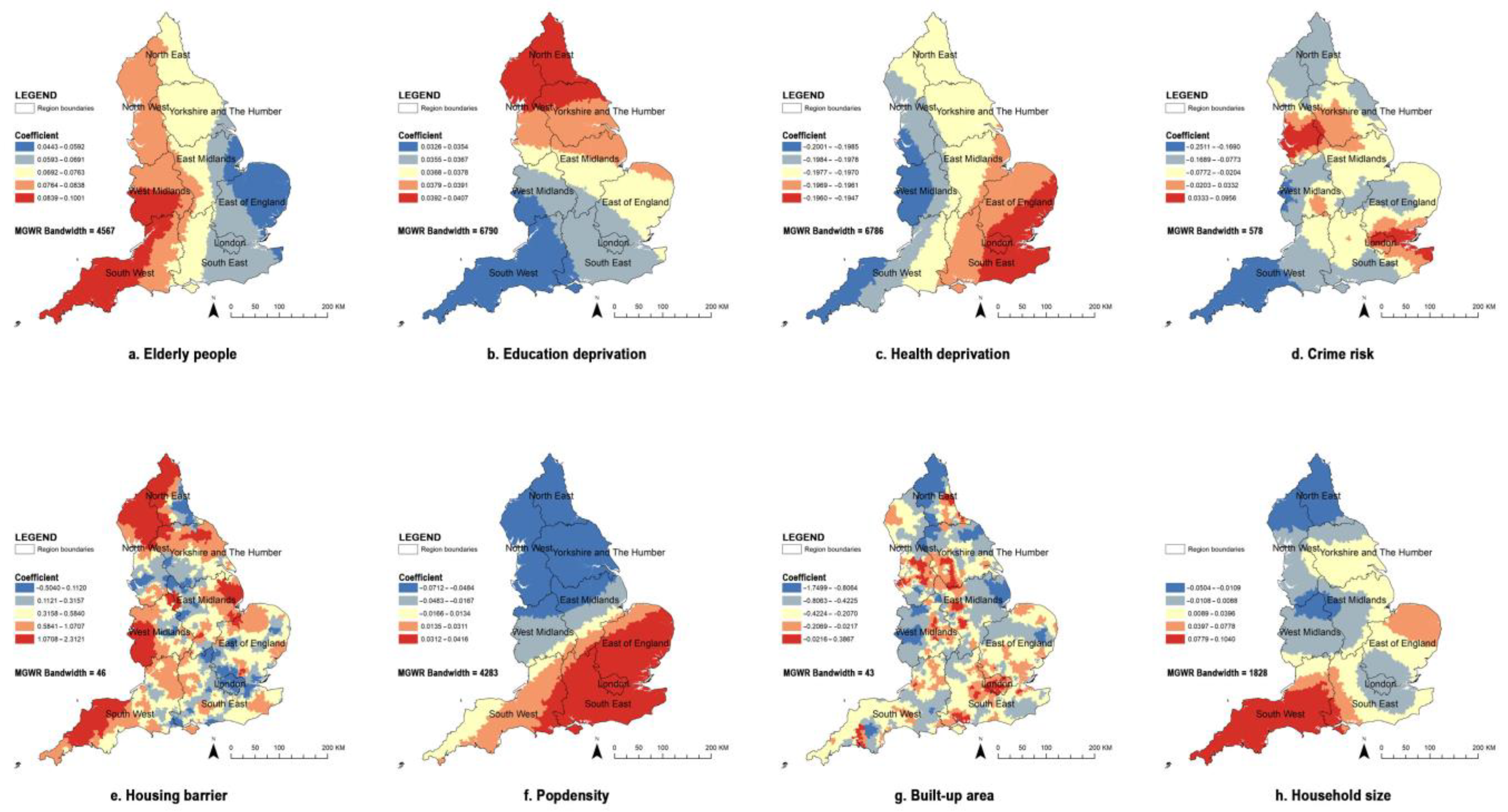
3.4. The Spatial Pattern of Variables in the MGWR Model

The multi-scale geographically weighted regression (MGWR) model leverages the varying bandwidth scales of each variable to conduct a precise regression analysis of the relationship between socioeconomic factors and green space, thereby capturing the spatial patterns at higher spatial densities (Figure 3). The coefficient values of the influencing factors in the MGWR model are assigned to each region unit, effectively illustrating the spatial associations between different socioeconomic variables and the proximity to the nearest green space. This highlights the ability of the MGWR model to accurately capture the spatial relationships and provide valuable insights into the influence of various factors on the accessibility of green spaces.

3.4.1. Older Adults

The analysis of both the OLS regression and the MGWR model consistently revealed a positive relationship between the proportion of the population aged 70 and older and the distance to the nearest green space. The average MGWR coefficient for this relationship was 0.073 (SD = 0.009). This indicates that areas with a higher percentage of older individuals tend to have greater distances to access green spaces. The MGWR model further identified spatial variations in this association, primarily concentrated in the Southwest region (Coef = 0.839~0.1001). The strength of this association gradually diminished towards the East of England region (Coef = 0.443~0.0592).

3.4.2. Education Deprivation

In the context of education, the OLS regression analyses revealed a positive association between educational deprivation and the distance to the nearest green space (Coef = 0.012; SE = 0.003). This finding suggests that areas with higher levels of educational deprivation tend to have greater distances to access green spaces. However, the MGWR model further elucidated this relationship by identifying specific geographic regions where educational inequalities in green space access are most prominent. Notably, the Northeast region of England exhibited higher coefficients ranging from 0.0392 to 0.0407, while the Southwest regions demonstrated lower coefficients ranging from 0.0326 to 0.0354.

3.4.3. Health Deprivation

In terms of health, in contrast to the findings of the OLS regression analysis (Coef = 0.254; SE = 0.059), the MGWR model revealed a significant and negative relationship between health deprivation and the distance to the nearest green space (mean: −0.197; SD = 0.001). This indicates that as the distance from the nearest green space increases, the health deprivation index decreases, suggesting higher overall health levels. Specifically, the MGWR model identified significant associations between PGS and health levels in specific regions. The Southeast region of England exhibited the highest coefficients ranging from −0.1960 to −0.1947. These associations gradually increased towards the West Midlands region and the Southwest region, with coefficients ranging from −0.2001 to −0.1985. These findings reveal the varying impacts of green space proximity on health deprivation across different geographic areas.

3.4.4. Crime Risk

Regarding the relationship between crime rates and distance to the nearest green space, the OLS model suggests a statistically significant negative correlation (Coef = −0.015; SE = 0.074). The MGWR model further investigated this relationship and confirmed that crime rates show a negative correlation with PGS inequality (Coef = −0.033; SD = 0.071). However, this relationship is reversed in specific areas, such as Northwest regions, including Lancashire, Sefton, Liverpool, East Merseyside, and Halton, as well as in London, Essex, Thurrock, and Kent (Coef = 0.0333~0.0956). These areas, along with their surrounding regions, exhibit a circular distribution pattern, where crime risk and PGS accessibility are positively associated. These findings from the MGWR model demonstrate the complex spatial patterns and variations in the relationship between crime rates and proximity to green spaces.

3.4.5. Housing Barrier

Regarding housing barriers, the MGWR model reveals that individuals facing housing service barriers are more likely to have long distances to public green spaces (Coef = 0.299; SD = 0.311). This association is particularly prevalent in regions, including most areas in the North of England and some areas in the Southwest and West Midlands of England (Coef = 1.0708~2.3121). However, the relationship reversed in specific areas, especially in Greater London (Coef = −0.5040). The coefficients of the housing barrier demonstrate the most significant variation, with the minimum coefficient (−0.5040) and the maximum coefficient (2.3121) representing the highest difference values.

4. Discussion

4.1. Main Findings

Our research contributes to the existing knowledge of the complex spatial relationships between public green spaces (PGS) and various indicators of low socioeconomic status. By employing local spatial regression techniques, we investigated the spatial variation of PGS inequality and identify regions characterised by significant deficiencies in PGS provision. In addition to uncovering regional-level trends in PGS inequality, our study offers detailed analyses that highlight the spatial heterogeneity of PGS inequality across dimensions such as crime risk, housing, age, education, and health. We discuss the underlying factors and policy implications of the relationships between specific socioeconomic variables and green spaces, which can also be relevant in other contexts. Examining PGS inequality at the local scale provides insights into the differing experiences of various social groups and can inform PGS planning and policy development strategies.

4.2. Contrasting the OLS and MGWR Models

The comparison between the ordinary least squares (OLS) model and the geographically weighted regression (MGWR) model reveals divergent findings regarding the relationship between socioeconomic characteristics and green areas. While the OLS model demonstrates a reasonable fit, it falls short of fully capturing the association between green space and socioeconomic factors, as indicated by an R 2 value of 0.434 and an AICc value of 29,805.630 (Table 1). This limitation stems from the OLS model’s inability to account for spatial information comprehensively. In contrast, the MGWR model incorporates multiple spatial scales for each impact factor, enabling localised estimation of regression parameters and spatial prediction of socioeconomic variables. Our study aligns with previous research that conducted comparative analyses, demonstrating the superior model-fitting performance of MGWR over OLS [78,79,80,81,82]. By employing the local regression coefficients of the MGWR model, we provide more explanatory results regarding the relationship between green space and various socioeconomic variables in England. The MGWR approach considers the influence of socioeconomic factors on green space across different spatial scales, thereby mitigating the impact of the number of factors on the relative magnitude of regression coefficients during the modelling process [83].

4.3. Green Space and Socioeconomic Factors

Our study unveils the spatial relationships between socioeconomic variables and green spaces contributing to a comprehensive understanding of their interplay. In our analysis, we observed distinct findings across five dimensions: crime risk, housing barrier, age, education deprivation, and health deprivation. Regarding crime risk, the OLS model initially revealed a negative association between crime risk and the distance to public green spaces. However, upon closer examination, the MGWR model identified a positive association between crime rates and green space accessibility in certain regions, especially in Greater London. These findings deviate from previous studies that often found a negative correlation between green spaces and crime rates [13,84]. However, alternative perspectives propose that specific green spaces with limited visibility might facilitate criminal activities by reducing surveillance from the community [85]. Prior studies investigating crime rates and green space often controlled for socio-demographic confounders, neglecting the combined effects of multiple factors. Our study incorporated various factors simultaneously, revealing different findings in England. While some high-crime-risk areas exhibit high green space accessibility, particularly in densely populated public centres (e.g., London, Essex, Thurrock, Kent), most regions (e.g., Cambridgeshire, Yorkshire and the Humber) show a negative association between crime risk and proximity to green spaces. Our study highlights the importance of effectively managing areas with higher crime rates to improve safety and enhance the utilisation of public green spaces (PGS). Existing research supports the notion that well-managed parks with features such as fencing, lighting, and security measures tend to have lower crime rates compared to poorly maintained ones lacking basic facilities [86]. However, the period from 2010 to 2019 witnessed a series of austerity measures in England, resulting in substantial reductions in local authority services, including park provision. These budget cuts have forced changes in governance and made it challenging to maintain existing parks [87]. As exemplified by Luxmore Gardens in the London Borough of Lewisham, neglected green spaces have earned negative reputations, discouraging their use due to a lack of maintenance and supervision, leading to them being derisively referred to as “dog poo parks” by residents. Our findings emphasise that the management of green spaces constitutes a complex system, and the maintenance and supervision of these areas significantly impact people’s exposure to green spaces.
In terms of housing barriers, our study reveals that areas in England characterised by housing barriers are often situated at a considerable distance from green spaces. This finding aligns with the discourse on the green movement in Western cities, which intersects with environmental justice and gentrification theory. Scholars have identified the phenomenon of “green gentrification”, whereby the emphasis on green spaces leads to the appreciation of surrounding properties and commercial transformations, thereby excluding disadvantaged communities and exacerbating their housing predicaments [88]. Furthermore, existing literature examining housing planning has indicated a positive correlation between green space and housing values, suggesting that proximity to desirable green spaces may demand higher housing costs, which can be unattainable for disadvantaged groups with limited financial resources [89]. The findings of a property value study in England indicate that green spaces in the region command a significant price premium, resulting in indirect inflation of environmental amenities’ prices [90]. Consequently, this phenomenon can negatively impact access to green spaces for disadvantaged groups with lower incomes. The increased property values may lead to higher living costs in areas with ample green spaces, making it challenging for individuals with limited financial means to afford housing in such neighbourhoods, thus restricting their access to these beneficial natural areas. Furthermore, the UK government’s promotion of localism and the ‘Big Society’ agenda has encouraged communities and volunteers to fill gaps in services, including the management and maintenance of green spaces. However, this approach has introduced complexities, as the responsibility for green spaces that face closure has been shifted to volunteers and residents. While this effort promotes community engagement and involvement, it can also lead to disparities in access to quality green spaces [91]. Some volunteer groups may lack the necessary time, skills, and experience required to apply for grants and effectively manage green spaces. Consequently, this may result in unequal distribution of well-maintained and properly managed green areas across different communities, further exacerbating PGS inequality for vulnerable and disadvantaged groups. Our study offers a distinct perspective from studies that primarily evaluate regional ecological, economic, and political development based on housing values. The findings underscore the pressing need for accessible green spaces among disadvantaged groups with limited housing options.
While previous studies have established connections between green space and factors such as age, education, and health [12,16,33], our research diverges by focusing on the proximity to green spaces rather than solely assessing their quality and quantity. We argue that the distance to green space serves as a crucial measure of its perceived value for vulnerable populations [42,43,88]. Our study findings indicate that communities with a higher proportion of older adults and lower educational attainment tend to experience limited access to green spaces. This suggests that these vulnerable groups may face challenges in benefiting from the positive impacts of nearby green spaces on health and well-being, which have been demonstrated in previous research [13,41]. Interestingly, our study reveals a unique observation, indicating that individuals with high health deprivation are more likely to live closer to green spaces. This may be attributed to the fact that residents with pre-existing medical conditions may actively choose to reside in neighbourhoods with low green space proximity, as easy access to green spaces can offer opportunities for physical activity, which is known to positively impact physical health [7,8,9,10]. Moreover, physically healthy residents have more modes of transportation such as (bicycles, cars, and public transportation) and are willing to choose parks that are farther away but of better quality to enjoy physical activities. Moreover, our analysis uncovers spatial heterogeneity in the presence of inequality, underscoring the significance of considering the complex relationship between the distance to the nearest green space and various socioeconomic variables in the planning and development of green spaces. These spatial disparities highlight the need for tailored interventions and policies that address the specific needs of different communities and ensure equitable access to green spaces.
Furthermore, our study’s findings highlighted the comparison between green space accessibility evident during both the COVID-19 pandemic and typical circumstances. Notably, an analysis of 190 adult physical activity reports from the British COVID-19 pandemic context demonstrated that vulnerable groups experienced reduced physical activity levels [92]. In contrast, non-vulnerable groups, particularly those with higher incomes, engaged in more intense physical activity [92]. Our research validates that the inequalities in green space access persisted for vulnerable groups not only in regular times but also amid the COVID-19 pandemic. This situation likely exacerbated pre-existing health disparities. The lockdown period amplified the need for parks that featured lower foot traffic and shorter distances, which can be an effective place for residents to decrease their depression during COVID-19 [93]. However, it is noteworthy that studies have indicated that the distribution of public green spaces in England posed challenges to meeting social distancing requirements [94]. Therefore, our study underscores the imperative of enacting policies targeted at enhancing both the accessibility and allocation of public green spaces. This emphasis on policy intervention is crucial for addressing the compounded challenges faced by vulnerable groups and ensuring equitable access to green spaces, a need that has been further highlighted by the unique circumstances of the pandemic.

4.4. Policy Implications

Our study presents substantial policy implications for public green space (PGS) planning, with a primary focus on green space inequalities experienced by disadvantaged groups. Firstly, our research highlights a prevailing oversight in current PGS planning, wherein the socio-economic characteristics of vulnerable populations are often neglected, compared with population distribution. To bridge this gap, we advocate for comprehensive measures, encompassing robust green space management, the establishment of green space registers, and documentation of community green infrastructure management. A thorough green space impact assessment across England is crucial to ensuring equitable and inclusive PGS planning.
Secondly, the findings of this study emphasised the significance of analysing and categorising the socio-economic characteristics of the population across different dimensions. For example, in our study, older adults in the South West and the West Midlands face significant green space inequalities (Coef = 0.839~0.1001), while disadvantaged groups with limited education in the East Midlands and East End of England struggle with long distances to access green spaces (Coef = 0.0392~0.0407). Housing barriers significantly hinder access for vulnerable groups in the North East and North West of England (Coef = 1.0708~2.3121), but crime rates do not exhibit the same effect (Coef = −0.1689~−0.1690). This approach yields a more nuanced understanding of the diverse needs and challenges faced by disadvantaged groups, consequently informing targeted and inclusive PGS planning strategies. Furthermore, achieving sustainable resource allocation in PGS management is essential in addressing environmental injustices and mitigating the unsustainable consequences of green gentrification. Public policy reforms are necessary to attain equitable and sustainable development outcomes, including improving the accessibility of green spaces to various disadvantaged groups by reducing walking distances.
Thirdly, our findings underscore the importance of adopting a strategic focus on the local development period, ensuring careful consideration and balance of the needs of disadvantaged groups. Inclusivity is essential for the sustainable development of a city, and the active involvement of different disadvantaged groups in the PGS planning process is imperative, allowing them to participate in decision making, providing feedback, and co-designing PGS components. This inclusive approach ensures that the unique perspectives and needs of vulnerable populations are considered, fostering a more socially just and equitable PGS development.
Moreover, developing a methodology to assess regional disparities in PGS inequality is vital, particularly for demographic analysis in PGS system design. Our study based on geographic information system (GIS) technology, proves to be effective in evaluating green space inequality, serving as a basis for conducting large-scale greening assessments and developing zoning plans. This approach facilitates the incorporation of the results from local models into PGS planning processes, considering the influence of various factors on environmental development and management. It enables us to comprehend the deprivation factors affecting vulnerable groups and assess the dynamics of different green space types. In addition, this approach helps map green space provision and offers informed recommendations for zoning planning and management, contributing to a more equitable distribution of resources.

4.5. Future Studies

Building upon our study, there are several avenues for future research. Firstly, future research should endeavour to enhance the precision of green space accessibility assessment and environmental equity evaluation. Our current study centrally scrutinises the issue of green space inequality experienced by disadvantaged groups, with a predominant focus on publicly accessible green spaces within our dataset. Public green spaces exhibit heightened safety standards and enhanced accessibility attributes including infrastructure provisions, green space maintenance, road safety considerations, gradients, restroom facilities, and more, all of which have been empirically established as prerequisites for disadvantaged groups [55,56]. Moreover, empirical research has identified a causal relationship between investments in public green spaces and regional economic development [95], while the ancillary resources surrounding public green spaces, such as medical facilities and employment opportunities, are of critical importance to disadvantaged groups [96,97]. However, the discourse surrounding environmental equity still offers considerable scope for further refinement. To illustrate, our study employs a measure of green accessibility predicated on the minimum distance to publicly accessible green spaces. This measure, however, fails to account for the immediacy with which rural residents may encounter natural green spaces such as pastures and forests upon leaving their residences, thereby benefiting from the positive attributes associated with these natural environments. Our study’s findings are circumscribed to quantifying individuals’ walking distance to the nearest publicly accessible green spaces, without considering their access to natural green spaces. This limitation underscores that assessing green accessibility solely in terms of public green spaces may offer an incomplete representation of the environmental equity experienced by individuals. Consequently, future research in the domain of environmental equity should encompass natural green spaces within its purview to facilitate a more holistic evaluation of green equity.
Moreover, future research should shift its focus towards measuring people-centric, perceived spaces rather than spatial accessibility alone. Our study employed spatial accessibility as a metric to gauge the ease with which individuals can access green spaces. However, relying solely on accessibility metrics may yield biased results and may fail to comprehensively reflect human experiences. Recent studies have shown that perceptible access may offer a better measurement of people’s perceptions of environmental equity [98]. For instance, Liu et al. examined perceptible access during the COVID-19 pandemic and found that perceived accessibility seemed to be a reasonable proxy for transportation equity [99]. Consequently, future research on environmental equity should transition from a one-dimensional spatial accessibility perspective to a more comprehensive, people-centric, and perceptible accessibility framework that allows for nuanced assessments and comparisons across different environments.
Perceived accessibility has gradually gained attention in the field of accessibility research [100,101,102]. Factors influencing green space perception encompass place uniqueness, place satisfaction, a sense of identity, and attachment, among others [103]. Additionally, perceived safety is deemed a pivotal factor influencing perception, particularly for individuals with mobility impairments [104]. However, previous research has predominantly focused on older adults or individuals with mobility impairments, limiting the generalisability of findings to broader demographic groups [101,105]. To address this gap, Ayala-Azcárraga et al. conducted a study involving multiple parks in Mexico City, investigating users’ perceptions of the park, and found that users’ experiences of green spaces varied under different time and weather conditions [106]. Nevertheless, a limitation of this study was that it only assessed the perceptions of users who had already visited the parks and did not investigate the perceptions of non-visitors. Future research on perceptible accessibility could potentially address the following key areas. Firstly, the measurement of perceivable access remains an area that warrants further investigation. Among the existing studies, the Perceived Accessibility Scale (PAC) has been developed as a tool to assess perceived accessibility [107]. Nonetheless, it is worth noting that there are studies within the domain of perceived accessibility that may not adequately capture this concept [108]. Therefore, future research on perceived accessibility must aim to deepen our understanding of the multifaceted determinants that influence perceived accessibility. This prerequisite is essential for achieving a more comprehensive grasp of environmental equity. Secondly, understanding how the perceived accessibility of green spaces changes over time has also been identified as a future research direction [109,110]. Given the considerable seasonal variations experienced by green spaces, examining perceived accessibility across different temporal periods can significantly contribute to the development of green infrastructure strategies that are adaptable to various seasons. This, in turn, can facilitate the enhancement of environmental equity and foster social inclusion, particularly among disadvantaged groups. The insights garnered from perception surveys can inform targeted interventions and guide future strategic planning efforts related to green infrastructure.
Finally, subsequent investigations should adopt more precise methodologies to delve into the effects of green spaces on the dynamics of green exercise participation. Leveraging modern movement tracking applications capable of recording and sharing trajectory data offers the potential to consolidate substantial datasets, encompassing metrics such as movement route length and walk frequency. This strategy facilitates a comprehensive assessment of movement patterns within green spaces, shedding light on the impact of attractiveness-enhancing interventions. The amalgamation of diverse data sources and methodological techniques not only provides a promising pathway for optimising green space layouts but also holds the promise of improving the seamless facilitation of physical activities within these environments. This proactive and integrated perspective not only deepens our understanding of the intricate interplay between environmental design and exercise trends but also offers practical insights that can actively shape urban planning strategies.

4.6. Limitations

This study has certain limitations that should be acknowledged. Firstly, the green space assessed in this study was measured by distance to the nearest green space area, which may not provide a comprehensive evaluation of PGS inequality. Secondly, the use of administrative divisions (neighbourhoods) as the geographical unit may compromise the interpretation of the data, as it overlooks the socioeconomic diversity within certain communities. Thirdly, despite incorporating various socioeconomic characteristics, it is important to recognise that the full range of disadvantaged groups may not have been fully accounted for due to limitations in the available data. Fourthly, our paper does not discuss the accessibility and environmental equity of natural undeveloped green spaces for disadvantaged groups. Our research scope is limited to publicly accessible green spaces, which may overlook the impact of natural green spaces on residents. Our study cannot measure the issue of green inequality for residents living around natural undeveloped green spaces.

5. Conclusions

This study aimed to comprehensively investigate spatial disparities in accessibility to public green spaces (PGS) among disadvantaged groups, focusing on key variables that encapsulate the vulnerability of such groups: age, educational deprivation, health disparities, crime rates, and housing barriers. Through the application of ordinary least squares (OLS) and multiscale geographically weighted regression (MGWR) techniques, we examined the intricate relationship between proximity to public green spaces and the challenges confronted by disadvantaged communities. The outcomes of this study revealed evident inequities in public green space access for vulnerable groups, with older adults and individuals facing educational and healthcare limitations experiencing difficulties in their access to green spaces. Moreover, the barrier of inadequate housing significantly compounds the hindrances faced by these disadvantaged groups in accessing public green spaces. An intriguing observation emerges from the positive association between crime risk and distance to public green spaces in most areas, contrasting with specific regions displaying a negative correlation. This study provides a valuable vulnerable group perspective for examining PGS inequities and presents priority areas for mitigating these inequities in future public green space system planning and policy development. By recognising the distinct needs and challenges faced by vulnerable groups, policymakers and planners can adopt targeted strategies to ensure more equitable access to green spaces. Sustainable resource allocation, addressing environmental injustices and the consequences of green gentrification, and engaging disadvantaged groups in the planning process are crucial steps toward achieving equitable and inclusive public green space environments. In addition, our findings emphasised the application of GIS techniques in evaluating the efficiency and equality of green space construction. Local authorities and policymakers should develop targeted strategies by using GIS techniques to build more resilient, liveable, and harmonious communities.

Author Contributions

Conceptualisation, Z.B. and Y.B.; methodology, Y.B.; software, Y.B. and Z.B.; validation, Z.B. and T.G.; formal analysis, Z.B. and Y.B.; investigation, Z.B. and Y.B.; resources, T.G.; data curation, Y.B.; writing—original draft preparation, Z.B. and Y.B.; writing—review and editing, Y.B., Z.B., and T.G.; visualisation, Y.B.; supervision, T.G.; project administration, T.G.; funding acquisition, T.G. All authors have read and agreed to the published version of the manuscript.

Funding

This research received no external funding.

Institutional Review Board Statement

Not applicable.

Informed Consent Statement

Not applicable.

Data Availability Statement

Data are available from the corresponding authors upon request.

Conflicts of Interest

The authors declare no conflict of interest.

References

  1. Xu, C.; Chen, G.; Huang, Q.; Su, M.; Rong, Q.; Yue, W.; Haase, D. Can Improving the Spatial Equity of Urban Green Space Mitigate the Effect of Urban Heat Islands? An Empirical Study. Sci. Total Environ. 2022, 841, 156687. [Google Scholar] [CrossRef]
  2. Yang, W.; Yang, R.; Zhou, S. The Spatial Heterogeneity of Urban Green Space Inequity from a Perspective of the Vulnerable: A Case Study of Guangzhou, China. Landsc. Urban Plan. 2022, 130, 103855. [Google Scholar] [CrossRef]
  3. Zhang, L.; Yok, P.T.; Richards, D. Relative Importance of Quantitative and Qualitative Aspects of Urban Green Spaces in Promoting Health. Landsc. Urban Plan. 2021, 213, 104131. [Google Scholar] [CrossRef]
  4. Akpinar, A. How Is Quality of Urban Green Spaces Associated with Physical Activity and Health? Urban For. Urban Green. 2016, 16, 76–83. [Google Scholar] [CrossRef]
  5. Zhang, L.; Wu, Y. Negative Associations between Quality of Urban Green Spaces and Health Expenditures in Downtown Shanghai. Land 2022, 11, 1261. [Google Scholar] [CrossRef]
  6. Mitchell, R.; Astell-Burt, T.; Richardson, E.A. A comparison of green space indicators for epidemiological research. J. Epidemiol. Community Health 2011, 65, 853–858. [Google Scholar] [CrossRef] [PubMed]
  7. Dempsey, S.; Lyons, S. Urban Green Space and Obesity in Older Adults: Evidence from Ireland. SSM-Popul. Health 2018, 4, 206–215. [Google Scholar] [CrossRef]
  8. Lambert, K.A.; Bowatte, G.; Tham, R. Residential Greenness and Allergic Respiratory Diseases in Children and Adolescents—A Systematic Review and Meta-Analysis. Environ. Res. 2017, 159, 212–221. [Google Scholar] [CrossRef]
  9. Ordóñez, C.; Wheeler, M.A.; Raynor, K.; Panza, L.; Seely, H.; Adamovic, M. Advancing Research on Urban Greenspace Experiences and Perceptions in Disadvantaged Communities: A Social Housing Perspective. Urban For. Urban Green. 2022, 77, 127754. [Google Scholar] [CrossRef]
  10. Tamosiunas, A.; Grazuleviciene, R.; Luksiene, D.; Dedele, A.; Reklaitiene, R.; Baceviciene, M.; Vencloviene, J.; Bernotiene, G.; Radisauskas, R.; Malinauskiene, V.; et al. Accessibility and Use of Urban Green Spaces, and Cardiovascular Health: Findings from a Kaunas Cohort Study. Environ. Health 2014, 13, 20. [Google Scholar] [CrossRef]
  11. Braveman, P.; Gruskin, S. Defining Equity in Health. J. Epidemiol. Community Health 2003, 57, 254–258. [Google Scholar] [CrossRef]
  12. Chen, Y.; Yue, W.; La Rosa, D. Which Communities Have Better Accessibility to Green Space? An Investigation into Environmental Inequality Using Big Data. Landsc. Urban Plan. 2020, 204, 103919. [Google Scholar] [CrossRef]
  13. Choi, Y.J.; Matz-Costa, C. Perceived Neighborhood Safety, Social Cohesion, and Psychological Health of Older Adults. Gerontologist 2018, 58, 196–206. [Google Scholar] [CrossRef]
  14. Du, Y.; Huang, W. Evaluation of Street Space Quality Using Streetscape Data: Perspective from Recreational Physical Activity of the Elderly. ISPRS Int. J. Geo-Inf. 2022, 11, 241. [Google Scholar] [CrossRef]
  15. Giatti, L.; Barreto, S.M.; César, C.C. Unemployment and Self-Rated Health: Neighborhood Influence. Soc. Sci. Med. 2010, 71, 815–823. [Google Scholar] [CrossRef] [PubMed]
  16. Mitchell, R.; Popham, F. Effect of Exposure to Natural Environment on Health Inequalities: An Observational Population Study. Lancet 2008, 372, 1655–1660. [Google Scholar] [CrossRef]
  17. Rigolon, A.; Browning, M.H.E.M.; McAnirlin, O.; Yoon, H. Green Space and Health Equity: A Systematic Review on the Potential of Green Space to Reduce Health Disparities. Int. J. Environ. Res. Public Health 2021, 18, 2563. [Google Scholar] [CrossRef]
  18. Guo, Y.; Lei, G.; Zhang, L. Quality Evaluation of Park Green Space Based on Multi-Source Spatial Data in Shenyang. Sustainability 2023, 15, 8991. [Google Scholar] [CrossRef]
  19. Hsu, Y.-Y.; Hawken, S.; Sepasgozar, S.; Lin, Z.-H. Beyond the Backyard: GIS Analysis of Public Green Space Accessibility in Australian Metropolitan Areas. Sustainability 2022, 14, 4694. [Google Scholar] [CrossRef]
  20. Nesbitt, L.; Meitner, M.J.; Girling, C.; Sheppard, S.R.J.; Lu, Y. Who Has Access to Urban Vegetation? A Spatial Analysis of Distributional Green Equity in 10 US Cities. Landsc. Urban Plan. 2019, 181, 51–79. [Google Scholar] [CrossRef]
  21. Wolch, J.R.; Byrne, J.; Newell, J.P. Urban Green Space, Public Health, and Environmental Justice: The Challenge of Making Cities ‘Just Green Enough’. Landsc. Urban Plan. 2014, 125, 234–244. [Google Scholar] [CrossRef]
  22. Xiao, Y.; Wang, Z.; Li, Z.; Tang, Z. An Assessment of Urban Park Access in Shanghai. Landsc. Urban Plan. 2017, 157, 383–393. [Google Scholar] [CrossRef]
  23. Talen, E. The Social Equity of Urban Service Distribution: An Exploration of Park Access in Pueblo, Colorado, and Macon, Georgia. Urban Geogr. 1997, 18, 521–541. [Google Scholar] [CrossRef]
  24. The Trust for Public Lands. The Trust for Public Lands United States of America. 2019. Available online: https://dopa-explorer.jrc.ec.europa.eu/wdpa/555610662 (accessed on 23 August 2023).
  25. National Bureau of Statistics of China. Compilation Regulation of Zoning Code and Urban-Rural Code for National Census. 2009. Available online: http://www.stats.gov.cn/tjsj/tjbz/200911/t20091125_8667.html (accessed on 23 August 2023).
  26. Irvine, K.N.; Warber, S.L.; Devine-Wright, P.; Gaston, K.J. Understanding Urban Green Space as a Health Resource: A Qualitative Comparison of Visit Motivation and Derived Effects among Park Users in Sheffield, UK. Int. J. Environ. Res. Public Health 2013, 10, 417–442. [Google Scholar] [CrossRef] [PubMed]
  27. Pope, D.; Tisdall, R.; Middleton, J.; Verma, A.; van Ameijden, E.; Birt, C.; Macherianakis, A.; Bruce, N.G. Quality of and Access to Green Space in Relation to Psychological Distress: Results from a Population-Based Cross-Sectional Study as Part of the EURO-URHIS 2 Project. Eur. J. Public Health 2018, 28, 35–38. [Google Scholar] [CrossRef] [PubMed]
  28. Ord, K.; Mitchell, R.; Pearce, J. Is level of neighbourhood green space associated with physical activity in green space? Int. J. Behav. Nutr. Phys. Act. 2013, 10, 127. [Google Scholar] [CrossRef] [PubMed]
  29. Schüle, S.A.; Hilz, L.K.; Dreger, S.; Bolte, G. Social Inequalities in Environmental Resources of Green and Blue Spaces: A Review of Evidence in the WHO European Region. Int. J. Environ. Res. Public Health 2019, 16, 1216. [Google Scholar] [CrossRef]
  30. Luo, S.; Jiang, H.; Yi, D.; Liu, R.; Qin, J.; Liu, Y.; Zhang, J. PM2SFCA: Spatial Access to Urban Parks, Based on Park Perceptions and Multi-Travel Modes. A Case Study in Beijing. ISPRS Int. J. Geo-Inf. 2022, 11, 488. [Google Scholar] [CrossRef]
  31. Li, Z.; Liang, Z.; Feng, L.; Fan, Z. Beyond Accessibility: A Multidimensional Evaluation of Urban Park Equity in Yangzhou, China. ISPRS Int. J. Geo-Inf. 2022, 11, 429. [Google Scholar] [CrossRef]
  32. Wang, H.; Wei, X.; Ao, W. Assessing Park Accessibility Based on a Dynamic Huff Two-Step Floating Catchment Area Method and Map Service API. ISPRS Int. J. Geo-Inf. 2022, 11, 394. [Google Scholar] [CrossRef]
  33. You, H. Characterizing the Inequalities in Urban Public Green Space Provision in Shenzhen, China. Habitat Int. 2016, 56, 176–180. [Google Scholar] [CrossRef]
  34. Schumaker, N.H. Using Landscape Indices to Predict Habitat Connectivity. Ecology 1996, 77, 1210–1225. [Google Scholar] [CrossRef]
  35. Picascia, S.; Mitchell, R. Social integration as a determinant of inequalities in green space usage: Insights from a theoretical agent-based model. Health Place 2022, 73, 102729. [Google Scholar] [CrossRef] [PubMed]
  36. Krekel, C.; Kolbe, J.; Wüstemann, H. The Greener, the Happier? The Effect of Urban Land Use on Residential Well-Being. Ecol. Econ. 2016, 121, 117–127. [Google Scholar] [CrossRef]
  37. Rehling, J.; Bunge, C.; Waldhauer, J.; Conrad, A. Socioeconomic Differences in Walking Time of Children and Adolescents to Public Green Spaces in Urban Areas. Int. J. Environ. Res. Public Health 2021, 18, 2326. [Google Scholar] [CrossRef] [PubMed]
  38. Wüstemann, H.; Kalisch, D.; Kolbe, J. Access to Urban Green Space and Environmental Inequalities in Germany. Landsc. Urban Plan. 2017, 164, 124–131. [Google Scholar] [CrossRef]
  39. Markevych, I.; Maier, W.; Fuertes, E.; Lehmann, I.; von Berg, A.; Bauer, C.-P.; Koletzko, S.; Berdel, D.; Sugiri, D.; Standl, M.; et al. Neighbourhood Greenness and Income of Occupants in Four German Areas: GINIplus and LISAplus. Urban For. Urban Green. 2017, 21, 88–95. [Google Scholar] [CrossRef]
  40. Wang, R.; Grekousis, G.; Maguire, A.; McKinley, J.M.; Garcia, L.; Rodgers, S.E.; Hunter, R.F. Examining the Spatially Varying and Interactive Effects of Green and Blue Space on Health Outcomes in Northern Ireland Using Multiscale Geographically Weighted Regression. Environ. Res. Commun. 2023, 5, 035007. [Google Scholar] [CrossRef]
  41. Zasada, I.; Loibl, W.; Berges, R.; Steinnocher, K.; Köstl, M.; Piorr, A.; Werner, A. Rural–Urban Regions: A Spatial Approach to Define Urban–Rural Relationships in Europe. In Peri-Urban Futures: Scenarios and Models for Land Use Change in Europe; Springer: Berlin/Heidelberg, Germany, 2013; pp. 45–68. [Google Scholar] [CrossRef]
  42. Aamodt, G.; Nordh, H.; Nordbø, E.C.A. Relationships between socio-demographic/socio-economic characteristics and neighborhood green space in four Nordic municipalities—Results from NORDGREEN. Urban For. Urban Green. 2023, 82, 127894. [Google Scholar] [CrossRef]
  43. Wu, L.; Kim, S.K. Does Socioeconomic Development Lead to More Equal Distribution of Green Space? Evidence from Chinese Cities. Sci. Total Environ. 2021, 757, 143780. [Google Scholar] [CrossRef]
  44. Zandieh, R.; Martinez, J.; Flacke, J. Older Adults’ Outdoor Walking, and Inequalities in Neighbourhood Green Spaces Characteristics. Int. J. Environ. Res. Public Health 2019, 16, 4379. [Google Scholar] [CrossRef]
  45. Shoari, N.; Ezzati, M.; Doyle, Y.G.; Wolfe, I.; Brauer, M.; Bennett, J.; Fecht, D. Nowhere to Play: Available Open and Green Space in Greater London Schools. J. Urban Health 2021, 98, 375–384. [Google Scholar] [CrossRef] [PubMed]
  46. Roe, J.; Aspinall, P.A.; Ward Thompson, C. Understanding Relationships between Health, Ethnicity, Place and the Role of Urban Green Space in Deprived Urban Communities. Int. J. Environ. Res. Public Health 2016, 13, 681. [Google Scholar] [CrossRef] [PubMed]
  47. Kwan, M.-P. The Stationarity Bias in Research on the Environmental Determinants of Health. Health Place 2021, 70, 102609. [Google Scholar] [CrossRef] [PubMed]
  48. Wang, J.; Lee, K.; Kwan, M.-P. Environmental Influences on Leisure-Time Physical Inactivity in the US: An Exploration of Spatial Non-Stationarity. ISPRS Int. J. Geo-Inf. 2018, 7, 143. [Google Scholar] [CrossRef]
  49. Anguluri, R.; Narayanan, P. Role of Green Space in Urban Planning: Outlook towards Smart Cities. Urban For. Urban Green. 2017, 25, 58–65. [Google Scholar] [CrossRef]
  50. Senanayake, I.P.; Welivitiya, W.D.D.P.; Nadeeka, P.M. Urban Green Spaces Analysis for Development Planning in Colombo, Sri Lanka, Utilizing THEOS Satellite Imagery—A Remote Sensing and GIS Approach. Urban For. Urban Green. 2013, 12, 307–314. [Google Scholar] [CrossRef]
  51. Shekhar, S.; Aryal, J. Role of Geospatial Technology in Understanding Urban Green Space of Kalaburagi City for Sustainable Planning. Urban For. Urban Green. 2019, 46, 126450. [Google Scholar] [CrossRef]
  52. Dong, R.; Zhang, Y.; Zhao, J. How Green Are the Streets Within the Sixth Ring Road of Beijing? An Analysis Based on Tencent Street View Pictures and the Green View Index. Int. J. Environ. Res. Public Health 2018, 15, 1367. [Google Scholar] [CrossRef]
  53. Bai, Y.; Cao, M.; Wang, R.; Liu, Y.; Wang, S. How street greenery facilitates active travel for university students. J. Transp. Health 2022, 26, 101393. [Google Scholar] [CrossRef]
  54. Toftager, M.; Ekholm, O.; Schipperijn, J.; Stigsdotter, U.; Bentsen, P.; Grønbæk, M.; Randrup, T.B.; Jørgensen, F.K. Distance to Green Space and Physical Activity: A Danish National Representative Survey. J. Phys. Act. Health 2011, 8, 741–749. [Google Scholar] [CrossRef]
  55. Kou, R.; Ruth, F.H.; Cleland, C.; Ellis, G. Physical environmental factors influencing older adults’ park use: A qualitative study. Urban For. Urban Green. 2021, 65, 1618–8667. [Google Scholar] [CrossRef]
  56. Zhang, J.; Feng, X.; Shi, W.; Cui, J.; Peng, J.; Lei, L.; Zhang, J.; Thomas, A.; Jiang, Y.; Ma, J. Health promoting green infrastructure associated with green space visitation. Urban For. Urban Green. 2021, 64, 127237. [Google Scholar] [CrossRef]
  57. Office for National Statistics. How Has Lockdown Changed Our Relationship with Nature? 2021. Available online: https://www.ons.gov.uk/economy/environmentalaccounts/articles/howhaslockdownchangedourrelationshipwithnature/latest (accessed on 6 July 2023).
  58. Wang, R.; Wu, W.; Yao, Y.; Tan, W. “Green transit-oriented development”: Eploring the association between TOD and visible green space provision using street view data. J. Environ. Manag. 2023, 344, 118093. [Google Scholar] [CrossRef] [PubMed]
  59. UK Government. Planning Practice Guidance. 2019. Available online: https://www.gov.uk/government/collections/planning-practice-guidance (accessed on 29 May 2023).
  60. Stessens, P.; Canters, F.; Khan, A.Z. Exploring Options for Public Green Space Development: Research by Design and GIS-Based Scenario Modelling. Sustainability 2021, 13, 8213. [Google Scholar] [CrossRef]
  61. Mitropoulos, L.; Karolemeas, C.; Tsigdinos, S.; Vassi, A.; Bakogiannis, E. A composite index for assessing accessibility in urban areas: A case study in Central Athens, Greece. J. Transp. Geogr. 2023, 108, 103566. [Google Scholar] [CrossRef]
  62. He, Q.; Wang, Y.; Qiu, Q.; Su, Y.; Wang, Y.; Wei, G.; Li, J. Joint effects of air PM2.5 and socioeconomic dimensions on posted emotions of urban green space visitors in cities experiencing population urbanization: A pilot study on 50 cities of East China. Sci. Total Environ. 2023, 861, 160607. [Google Scholar] [CrossRef]
  63. Anwar, M.M.; Hashim, M.; Aziz, A.; Stocco, A.; Abdo, H.G.; Almohamad, H.; Al Dughairi, A.A.; Al-Mutiry, M. Urban Green Spaces Distribution and Disparities in Congested Populated Areas: A Geographical Assessment from Pakistan. Sustainability 2023, 15, 8059. [Google Scholar] [CrossRef]
  64. Bi, S.; Dai, F.; Chen, M.; Xu, S. A New Framework for Analysis of the Morphological Spatial Patterns of Urban Green Space to Reduce PM2.5 Pollution: A Case Study in Wuhan, China. Sustain. Cities Soc. 2022, 82, 103900. [Google Scholar] [CrossRef]
  65. Xu, Z.; Zhang, Z.; Li, C. Exploring Urban Green Spaces in China: Spatial Patterns, Driving Factors and Policy Implications. Land Use Policy 2019, 89, 104249. [Google Scholar] [CrossRef]
  66. Foody, G.M. Geographical Weighting as a Further Refinement to Regression Modelling: An Example Focused on the NDVI–Rainfall Relationship. Remote Sens. Environ. 2003, 88, 283–293. [Google Scholar] [CrossRef]
  67. Lu, B.; Brunsdon, C.; Charlton, M.; Harris, P. A Response to ‘A Comment on Geographically Weighted Regression with Parameter-Specific Distance Metrics’. Int. J. Geogr. Inf. Sci. 2019, 33, 1300–1312. [Google Scholar] [CrossRef]
  68. Hanchen, Y.; Fotheringham, A.S.; Li, Z. Inference in Multiscale Geographically Weighted Regression. Geogr. Anal. 2019, 52, 87–106. [Google Scholar] [CrossRef]
  69. Hutcheson, G.D. The Multivariate Social Scientist, 2nd ed.; SAGE Publications, Ltd.: Thousand Oaks, CA, USA, 1999; pp. 76–77. [Google Scholar]
  70. Lin, D.; Dean, P.F.; Ungar, L.H. VIF Regression: A Fast Regression Algorithm for Large Data. J. Am. Stat. Assoc. 2011, 106, 232–247. [Google Scholar] [CrossRef]
  71. Zhang, J.; Liu, J.; Yang, H.; Quan, J.; Wang, L.; He, Q.; Li, F. Satisfaction Evaluation for Underpass Green Spaces in Mountainous Cities under the Perspective of Environmental Perception. Buildings 2023, 13, 1489. [Google Scholar] [CrossRef]
  72. Husqvarna. Quantifying the Greenness of Global Cities. 2019. Available online: https://www.hPGSi.green/ (accessed on 7 June 2023).
  73. Davies, C.; Santo-Tomás Muro, R. Stewardship and Green Infrastructure in England. Planning Perspectives Informed through an Investigation of Urban Green Infrastructure. J. Environ. Plan. Manag. 2023, 1, 1–26. [Google Scholar] [CrossRef]
  74. Runnymede, R. The Runnymede Trust. 2023. Available online: https://www.runnymedetrust.org/ (accessed on 20 May 2023).
  75. Chen, E.; Ye, Z.; Wang, C.; Zhang, W. Discovering the Spatio-Temporal Impacts of Built Environment on Metro Ridership Using Smart Card Data. Cities 2019, 95, 102359. [Google Scholar] [CrossRef]
  76. Ma, X.; Zhang, J.; Ding, C.; Wang, Y. A Geographically and Temporally Weighted Regression Model to Explore the Spatiotemporal Influence of Built Environment on Transit Ridership. Comput. Environ. Urban Syst. 2018, 70, 113–124. [Google Scholar] [CrossRef]
  77. An, R.; Wu, Z.; Tong, Z.; Qin, S.; Zhu, Y.; Liu, Y. How the Built Environment Promotes Public Transportation in Wuhan: A Multiscale Geographically Weighted Regression Analysis. Travel Behav. Soc. 2022, 29, 186–199. [Google Scholar] [CrossRef]
  78. Chang Chien, Y.-M.; Carver, S.; Comber, A. Using Geographically Weighted Models to Explore How Crowdsourced Landscape Perceptions Relate to Landscape Physical Characteristics. Landsc. Urban Plan. 2020, 203, 103904. [Google Scholar] [CrossRef]
  79. Chen, Y.; Xu, Z.; Byrne, J.; Xu, T.; Wang, S.; Wu, J. Can Smaller Parks Limit Green Gentrification? Insights from Hangzhou, China. Urban For. Urban Green. 2021, 59, 127009. [Google Scholar] [CrossRef]
  80. Liu, K.; Qiao, Y.; Zhou, Q. Analysis of China’s Industrial Green Development Efficiency and Driving Factors: Research Based on MGWR. Int. J. Environ. Res. Public Health 2021, 18, 3960. [Google Scholar] [CrossRef] [PubMed]
  81. Mansour, S.; Al Kindi, A.; Al-Said, A.; Al-Said, A.; Atkinson, P. Sociodemographic Determinants of COVID-19 Incidence Rates in Oman: Geospatial Modelling Using Multiscale Geographically Weighted Regression (MGWR). Sustain. Cities Soc. 2021, 65, 102627. [Google Scholar] [CrossRef]
  82. Stewart, F.A.; Li, Z. Examining the Influences of Air Quality in China’s Cities Using Multi-scale Geographically Weighted Regression. Trans. GIS 2019, 23, 1444–1464. [Google Scholar] [CrossRef]
  83. Song, X.; Mi, N.; Mi, W.; Li, L. Spatial Non-Stationary Characteristics between Grass Yield and Its Influencing Factors in the Ningxia Temperate Grasslands Based on a Mixed Geographically Weighted Regression Model. J. Geogr. Sci. 2022, 32, 1076–1102. [Google Scholar] [CrossRef]
  84. Branas, C.C.; Cheney, R.A.; MacDonald, J.M.; Tam, V.W.; Jackson, T.D.; Ten Have, T.R. A Difference-in-Differences Analysis of Health, Safety, and Greening Vacant Urban Space. Am. J. Epidemiol. 2011, 174, 1296–1306. [Google Scholar] [CrossRef] [PubMed]
  85. Groff, E.; Mccord, E.S. The Role of Neighborhood Parks as Crime Generators. Secur. J. 2012, 25, 1–24. [Google Scholar] [CrossRef]
  86. Dempsey, N.; Burton, M.; Duncan, R. Evaluating the effectiveness of a cross-sector partnership for green space management: The case of Southey Owlerton, Sheffield, UK. Urban For. Urban Green. 2016, 15, 155–164. [Google Scholar] [CrossRef]
  87. Gibbons, S.; Mourato, S.; Resende, G.M. The Amenity Value of English Nature: A Hedonic Price Approach. Environ. Resour. Econ. 2014, 57, 175–196. [Google Scholar] [CrossRef]
  88. Xiao, Y.; Miao, S.; Zhang, Y.; Xie, B.; Wu, W. Exploring the Associations between Neighborhood Greenness and Level of Physical Activity of Older Adults in Shanghai. J. Transp. Health 2022, 24, 101312. [Google Scholar] [CrossRef]
  89. Smith, A.; Whitten, M.; Ernwein, M. De-municipalisation? Legacies of austerity for England’s urban parks. Geogr. J. 2023, 1–12. [Google Scholar] [CrossRef]
  90. Melissa García, L. Green Gentrification: Urban Sustainability and the Struggle for Environmental Justice. Local Environ. 2017, 22, 12. [Google Scholar] [CrossRef]
  91. Piaggio, M. The Value of Public Urban Green Spaces: Measuring the Effects of Proximity to and Size of Urban Green Spaces on Housing Market Values in San José, Costa Rica. Land Use Policy 2021, 109, 105656. [Google Scholar] [CrossRef]
  92. Trivedy, R.N.; Naomi, R.W.; Hannah, B.; Luisa, E.; Rosalind, M.E.; Shelley, L.; Casanova, A.; Sumathi, S.; Anjana, R.M.; Kumar, R.; et al. Behavioral Change Towards Reduced Intensity Physical Activity Is Disproportionately Prevalent Among Adults with Serious Health Issues or Self-Perception of High Risk During the UK COVID-19 Lockdown. Front. Public Health 2020, 8, 2296–2565. [Google Scholar] [CrossRef]
  93. Maury-Mora, M.; Gómez-Villarino, M.T.; Varela-Martínez, C. Urban green spaces and stress during COVID-19 lockdown: A case study for the city of Madrid. Urban For. Urban Green. 2022, 69, 127492. [Google Scholar] [CrossRef]
  94. Shoari, N.; Ezzati, M.; Baumgartner, J.; Malacarne, D.; Fecht, D. Accessibility and allocation of public parks and gardens in England and Wales: A COVID-19 social distancing perspective. PLoS ONE 2020, 15, 10. [Google Scholar] [CrossRef] [PubMed]
  95. Vandermeulen, V.; Verspecht, A.; Vermeire, B.; Huylenbroeck, V.G.; Gellynck, X. The use of economic valuation to create public support for green infrastructure investments in urban areas. Landsc. Urban Plan. 2011, 103, 198–206. [Google Scholar] [CrossRef]
  96. Kambites, C.; Owen, S. Renewed prospects for green infrastructure planning in the UK. Plan. Pract. Res. 2006, 21, 483–496. [Google Scholar] [CrossRef]
  97. Grant, M. European Healthy City Network Phase V: Patterns emerging for healthy urban planning. Health Promot. Int. 2015, 30, 54–70. [Google Scholar] [CrossRef]
  98. Yang, W.; Yang, R.; Li, X. A Canonical Correlation Analysis Study on the Association Between Neighborhood Green Space and Residents’ Mental Health. Urban Health 2023, 100, 696–710. [Google Scholar] [CrossRef]
  99. Liu, Q.; An, Z.; Liu, Y.; Ying, W.; Zhao, P. Smartphone-based services, perceived accessibility, and transport inequity during the COVID-19 pandemic: A cross-lagged panel study. Transp. Res. Part D Transp. Environ. 2021, 97, 102941. [Google Scholar] [CrossRef] [PubMed]
  100. Koppen, G.; Tveit, M.S.; Sang, O.Å.; Dramstad, W. The challenge of enhancing accessibility to recreational landscapes. Nor. Geogr. Tidsskr. Nor. J. Geogr. 2014, 68, 145–154. [Google Scholar] [CrossRef]
  101. Wojnowska-Heciak, M.; Suchocka, M.; Błaszczyk, M.; Muszyńska, M. Urban Parks as Perceived by City Residents with Mobility Difficulties: A Qualitative Study with In-Depth Interviews. Int. J. Environ. Res. Public Health 2022, 19, 2018. [Google Scholar] [CrossRef] [PubMed]
  102. Wang, D.; Brown, G.; Liu, Y.; Babiano, I.M. A comparison of perceived and geographic access to predict urban park use. Cities 2015, 42, 85–96. [Google Scholar] [CrossRef]
  103. Shahraki, A.A. Urban Planning for Physically Disabled People’s Needs with Case Studies. Spat. Inf. Res. 2021, 29, 173–184. [Google Scholar] [CrossRef]
  104. Najmeddin, S.; Ahmadi, M. Tailoring Coastal Park for the Use of Veterans and People with Physical-Motion Disabilities (Case Study: Noshahr Beach Park. Eur. Online J. Nat. Soc. Sci. 2015, 3, 646–656. [Google Scholar] [CrossRef]
  105. Perry, M.; Cotes, L.; Horton, B.; Kunac, R.; Snell, I.; Taylor, B.; Wright, A.; Devan, H. “Enticing” but Not Necessarily a “Space Designed for Me”: Experiences of Urban Park Use by Older Adults with Disability. Int. J. Environ. Res. Public Health 2021, 18, 552. [Google Scholar] [CrossRef] [PubMed]
  106. Azcárraga, C.A.; Diaz, D.; Zambrano, L. Characteristics of urban parks and their relation to user well-being. Landsc. Urban Plan. 2019, 189, 27–35. [Google Scholar] [CrossRef]
  107. Lättman, K.; Friman, M.; Olsson, L. Perceived Accessibility of Public Transport as a Potential Indicator of Social Inclusion. Soc. Incl. 2016, 4, 36–45. [Google Scholar] [CrossRef]
  108. Asumoto, S.; Nakaya, T.; Jones, A.P. Quantitative Environmental Equity Analysis of Perceived Accessibility to Urban Parks in Osaka Prefecture, Japan. Appl. Spat. Anal. Policy 2020, 14, 337–354. [Google Scholar] [CrossRef]
  109. Lättman, K.; Olsson, L.E.; Friman, M. A new approach to accessibility–Examining perceived accessibility in contrast to objectively measured accessibility in daily travel. Res. Transp. Econ. 2018, 69, 501–511. [Google Scholar] [CrossRef]
  110. Christoforidi, I.; Kollaros, D.; Papadakaki, M.; Psaroudaki, A.; Antoniou, T.; Ioannis, N.; Daliakopoulos, I.N. A novel index for assessing perceived availability and public demand for urban green space: Application in a Mediterranean island. Urban For. Urban Green. 2022, 69, 1618–8667. [Google Scholar] [CrossRef]
Figure 1. Theoretical framework.
Sustainability 15 13507 g001
Figure 2. The spatial distribution of the distance (km) to the nearest green space in England.
Sustainability 15 13507 g002
Figure 3. The spatial pattern of variables in the MGWR model.
Sustainability 15 13507 g003
Table 1. Variable descriptive analysis.
IndicatorVariableAbbr.DescriptionMeanS.D.
Green space Distance to nearest public green spaceGreen_disThe distance to the nearest public green space4.242.88
AgeOlder adultsRate_70Percentage of the population aged 70 and over in the whole population0.140.06
EducationEducation deprivationEDUSThe lack of attainment and skills in the local population21.6015.87
HealthHealth deprivationHSThe risk of premature death and the impairment of quality of life through poor physical or mental health−0.020.77
CrimeCrime riskCSThe risk of personal and material victimisation at the local level−0.010.70
HousingHousing barrierBHSThe physical and financial accessibility of housing and local services21.878.68
Control variancePopulationPOPDThe ratio of the population to the land area3488.033789.84
Built-up areaRBPercentage of built-up area0.580.37
Household sizeAVESIZEAverage household size2.370.23
Table 2. Regression results of the OLS model.
IndicatorVariableCoef.Robust SERobust tRobust PVIF
intercept3.2360.27811.6330.000 *-
Agerate_707.2690.7749.3950.000 *2.374
Educationedus0.0120.0034.6490.000 *2.797
Healthhs0.2540.0594.3120.000 *3.227
Crimecs−1.0150.074−13.8060.000 *2.785
Housingbhs0.1100.00520.5120.000 *1.330
Control variablepopdensity−0.0000.000−0.0740.000 *2.682
ratebuilt−2.9270.092−31.8020.000 *2.468
avehhsize−0.4050.108−3.7600.000 *1.349
Model diagnosticsMultiple R2: 0.435, adjusted R2: 0.434, AICc: 29,805.630, Koenher (BP): 534.420 *, Jarque–Bera: 102,799.494 *
Note: Coef. = coefficient; SE = standard error; AICc = AIC (Akaike information criterion) with a correction for small sample sizes; VIF = variance inflation factor. * p < 0.01.
Table 3. Statistics of MGWR regression coefficients.
IndicatorVariableBandwidthMGWR CoefficientsDirections of Relationship in the MGWR Model
MinMaxMeanSTD+ (%)+sig. (%)− (%)−sig. (%)
Intercept144−0.7621.147−0.1580.293----
AgeRate_7045670.0440.1000.0730.009100.00100.000.000.00
EducationEDUS67900.0330.0410.0370.001100.00100.000.000.00
HealthHS6786−0.200−0.195−0.1970.0010.000.00100.00100.00
CrimeCS578−0.2510.096−0.0330.07137.62.2862.427.10
HousingBHS46−0.5042.3120.2990.31191.0241.458.980.02
Control variablePOPD4283−0.0710.042−0.0060.04553.6619.1146.3434.66
RB43−1.7500.387−0.1730.22422.220.6877.7833.94
AVESIZE1828−0.0500.1040.0150.03022.1915.1877.810.10
Model diagnosticsMultiple R2 Adjusted R2 AICc BICMultiple R2 Adjusted R2
0.760 0.722 11,708.440 17,672.9180.760 0.722
Note: AICc = AIC (Akaike information criterion) with a correction for small sample sizes; BIC = Bayesian information criterion; +sig. (%) and −sig. (%) refer to the proportion of 5% significance for positive correlation and negative correlation, respectively.
Disclaimer/Publisher’s Note: The statements, opinions and data contained in all publications are solely those of the individual author(s) and contributor(s) and not of MDPI and/or the editor(s). MDPI and/or the editor(s) disclaim responsibility for any injury to people or property resulting from any ideas, methods, instructions or products referred to in the content.

