Article

Coast Change: Understanding Sensitivity to Beach Loss for Coastal Tourism in the Colombian Caribbean

by
Luana Carla Portz
1,*,
Yacira Sheilla Pérez Torres
2 and
Rogério Portantiolo Manzolli
1,*
1
Department of Geology and Geochemistry, Universidad Autónoma de Madrid, 28049 Madrid, Spain
2
Maestría de Investigación en Desarrollo Sostenible (MIDES), Departamento de Civil y Ambiental, Universidad de la Costa, Barranquilla 080020, Colombia
*
Authors to whom correspondence should be addressed.
Sustainability 2023, 15(18), 13903; https://doi.org/10.3390/su151813903
Submission received: 22 July 2023 / Revised: 5 September 2023 / Accepted: 13 September 2023 / Published: 19 September 2023
(This article belongs to the Special Issue Development Challenges in Coastal and Marine Tourism)

Abstract

:
Beach and sun tourism in the Colombian Caribbean is an extremely important activity that leads to social practices that generate recreational and economic activities directly impacting the environment. The research focuses on assessing the sensitivity to the loss of beaches as tourist resources in four locations within the Colombian Caribbean (Santa Verónica, Salinas del Rey, Bocatocino, and Las Arenas). The sensitivity indicator was developed using GIS to process variables such as the width of the usable beach, the presence of dunes, and rates of coastal erosion spanning from 2003 to 2019. Additionally, anthropic occupation was examined through satellite images. The results allowed for identifying vulnerability indices and recognizing the critical role of dunes in beach preservation. The study revealed that the analyzed beaches exhibited varying degrees of sensitivity. Notably, historical erosion rates and dunes were the most influential variables affecting sensitivity. In conclusion, understanding the sensitivity state concerning the loss of beach areas as tourist resources helps delineate stable sectors and those more susceptible to erosion processes. This knowledge proves invaluable in prioritizing the design and implementation of protective measures in areas requiring urgent attention.

1. Introduction

Tourism is widely regarded as one of the most significant economic activities on a global scale, constituting a primary economic pillar for many nations and contributing to the surge in travel to attractive destinations, including coastal areas and their beaches. However, it is crucial to underscore that these sensitive environments are susceptible to pollution and deterioration resulting from tourism activities carried out without proper planning and environmental considerations [1]. Furthermore, coastal zones and their adjacent areas are home to a substantial percentage of the world’s population, whose activities exert a substantial impact and lead to the degradation of coastal ecosystems, particularly beaches and dune systems [2].
Beaches encompass dynamic and fragile ecosystems where the continuous movement of sand, water, and air prevails. Over extended periods, sands transport considerable distances to gradually form beaches, exhibiting distinct morphological characteristics influenced by the interplay of waves, currents, sea level, and wind patterns. Additionally, anthropogenic factors significantly contribute to the shaping and alteration of these spaces. The construction of highways, urban infrastructure, and services introduces environmental imbalances, often leading to erosion processes [3]. Erosion processes can be comprehended as the negative disparity between sediment input and output within the beach system, ultimately manifesting as observable morphological alterations denoted by shoreline retreat [4].
About 70–80% of the world’s beaches are affected by erosion processes as a function of natural phenomena and anthropogenic hazards [5], which can modify the hydrodynamic and hydrological conditions on the beaches. Among the natural phenomena is the rise in sea level and the incidence of climate, decreasing the sedimentary contribution of rivers to the coasts. On the other hand, constant population growth and the need for urban development and tourism activities in coastal areas generate a high impact and degradation of coastal ecosystems, mainly beaches and coastal dune systems [2]. Among the main aspects that create negative impacts on the coasts is the construction and/or installation of infrastructure, which is considered one of the leading anthropic causes of changes in coastal dynamics, directly affecting the processes of sediment transport by waves and, therefore, increasing the sensitivity to coastal erosion processes [6].
Erosive processes are responsible for reducing or losing sediment in the beach–dune profile, and they generate changes in the system’s morphology due to a negative balance between sediment input and output [7]. The most notable effect of coastal erosion on tourist activities is the reduction in the width of the beach strip, causing a reduction in the availability of space on the coast, changes in local conditions for the development of recreational activities, and consequently, a reduction in carrying capacity, etc. [8]. The presence of dunes, in turn, is highlighted as a vital component in the response to coastal erosion, acting not only as a natural protective barrier, but also as an essential store of sediment [9]. The constant accumulation of sand and sediment from wind and sea currents attenuates the force of waves and storms and maintains a continuous supply of materials to recover eroded areas. This action is reinforced by the presence of native vegetation, in which these plants are adapted to the saline stress of the dunes, which contributes to the fixation of sediments and thus consolidates the dunes’ stability. The strategic conservation of coastal dunes, in addition to protecting coastal communities, ecosystems, and infrastructure, ensures a constant flow of essential sediments, playing a fundamental role in the sustainability of the coastal environment.
The Colombian Caribbean is considered a very important destination for visitors. It is one of the main tourist attractions in the country, mainly due to its strategic location, diversity of ecosystems, and valuable biological heritage [10]. The main departments for beach tourism in Colombia are Magdalena and Bolívar. As for the Atlántico department, the potential for beach tourism development is considered unfavorable in relation to other equivalent destinations. However, there are factors that characterize the department’s beaches and make them attractive to a fraction of tourists, namely silence, low level of development, ecosystems in good condition, etc. These characteristics give them a competitive advantage in planning and promoting sustainable tourism of natural resources [10].
As a case study, this research aims to diagnose the sensitivity to beach loss as a tourist resource on the coast of the Atlántico department, Colombia. Furthermore, this study seeks to provide insights into the sustainable management of beaches in Atlántico and establish an analytical framework that can be applied and expanded to other coastal regions.
This diagnosis aims to understand coastal dynamics, identifying the sectors with the highest erosion rates and imbalances in hydrodynamic, atmospheric, and hydrological conditions. The study aims to provide a knowledge base to develop strategies for conserving these coastal environments, contributing to improving the region’s tourist, commercial, and cultural activities. By understanding the potential effects of changes in the use and occupation of the coastal zone, the study seeks to contribute to the management of sustainable tourism and the preservation of the natural ecosystems of the beaches of the Atlántico department, emphasizing the importance of proper management to ensure the long-term viability of this crucial economic activity.
Finally, this study seeks to answer the following questions: Which sections of the coast of the Atlántico department, Colombia, have the highest erosion rates and consequent imbalance between hydrodynamic, atmospheric, and hydrological conditions? In addition, what are the main factors contributing to the increased sensitivity of beaches in the Atlántico department?

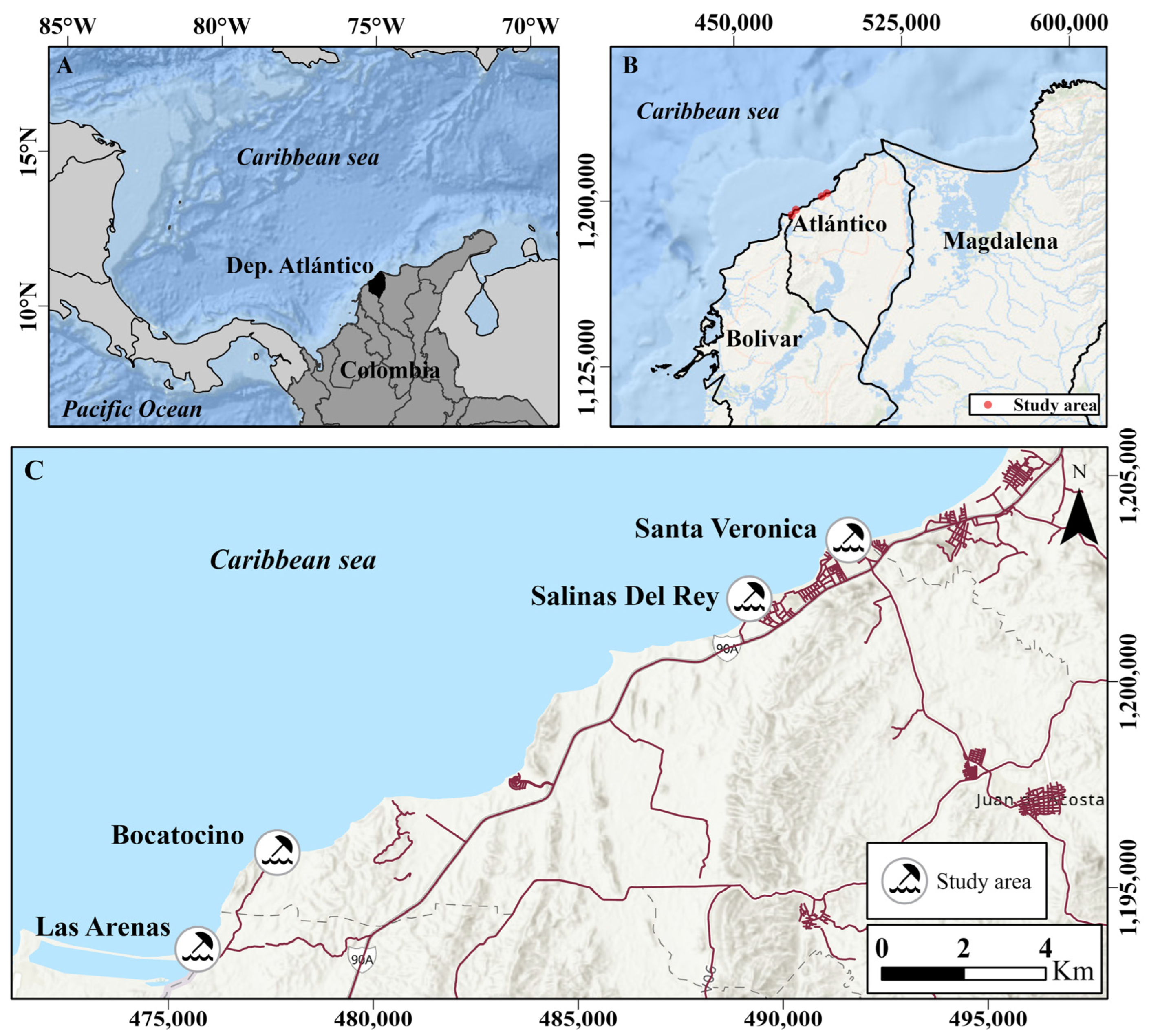
Description of the Study Area

The study area is located on the coast of the Atlántico department, Colombia. Four beaches were selected for a detailed analysis: Santa Veronica, Salinas del Rey, Bocatocino, and Las Arenas. The area is formed by sandy beaches and dune areas, is influenced by the dynamics between the Magdalena River and the Caribbean Sea, and presents a great variety of coastal ecosystems (Figure 1).
The wave heights in this area vary between 0.1 and 2.5 m [11]. Throughout the seasons, there are shifts in wave direction, which are associated with a noticeable decrease in wave height. The lowest wave heights are typically observed from August to October, whereas the most substantial swells occur between November and July [12]. The tides are mixed semidiurnal and range between 0.2 and 0.3 m, classifying as a micro-tidal beach. Liquid coastal drift occurs mainly in the southwesterly direction, and there is a slight reversal to the northeasterly direction in the rainy season [13].
Since the onset of the Quaternary period, the Magdalena River has played a crucial role in both direct and indirect intervention in erosion and coastal accretion processes, contributing to substantial sediment discharges. Colombia’s most extensive river system, the Magdalena River, carries an impressive annual sedimentary load of 144 × 106 tons/year [14].

2. Materials and Methods

This article used an innovative approach, combining Geographic Information Systems (GIS) and satellite image analysis. This approach covered the analysis of essential variables such as erosion rates, usable beach widths, the presence of dunes, and the mapping of urban structures.

2.1. Variation of Coastline—Digital Shoreline Analysis System (DSAS)

To assess the coastline variation of the beaches, we analyzed the positional changes between 2003 and 2019, focusing on the years 2003, 2011, 2013, and 2019. These specific years were selected based on a combination of factors, including the availability of relevant images and identifying significant changes within the time interval studied. Shoreline mobility was evaluated using the Digital Shoreline Analysis System-V5.0 (DSAS) software. The study considered several parameters: End Point Rate (EPR) was obtained by dividing the distance of the movement of the coast by the time elapsed between the positions of the initial and the final coast (m/year); Net Shoreline Movement (NSM) reported the distance between the oldest and youngest shorelines for each transect. Positive and negative values are provided for each measurement [15]
Shorelines were manually vectorized from medium spatial resolution imagery available in the databank in Google Software Earth Pro 7.3.6.9345 (64 bit). Using Google Earth images is a technique already established in several publications [16,17]. The scenes for each year were recorded in the UTM coordinate system and the WGS 1984 reference system, zone 18 North, and a Root Mean Square around 0.2 m were obtained. The mosaics were recorded based on an orbital satellite image available in the ArcGIS Pro software 3.1.2.
For the present study, the coastline was characterized as the position of the terrestrial interface in the sandy coastal areas, marked by the limit reached during the high tides. The limit was defined by a change of tonality in the sands of the beach [18].

2.2. Mapping of the Dune/Beach Area and Identification of Urban Structures

The vectorization of the dune and beach system was performed based on the 2019 image. Beaches formed by sand can be delimited in the terrestrial portion by the presence of dunes or cliffs and in the marine part by the change of tonality in the beach sands (according to the delimitation of the coastline). The identification of urban structures was carried out using satellite images from 2003 and 2019. The presence of occupations was observed in public or private areas.
The vectorization process in GIS involveed converting spatial features, such as dunes and urban structures, from raster images to vector format to identify geographical features accurately.

2.3. Indicator of Sensitivity to the Loss of Beaches as a Tourist Resource

The methodology used to determine the sensitivity to the loss of beaches as a tourism resource was adapted from a previous study [19]. Analyzing the beach as a tourist resource necessitates gathering information to define specific aspects, such as the portion of the beach utilized by users in relation to the available space, its stability (including reduced erosion processes or beach spreading processes), and its temporal persistence (involving high availability of sedimentary material, such as dunes, for instance) [19].
Several variables were employed to calculate the sensitivity to the loss of the beach as a tourist resource, including the available beach area, the presence of dunes, and rates of erosion and accretion of the coastline during the historical period. Geoprocessing tools were utilized to calculate these variables, and their incorporation was crucial for constructing the sensitivity index. The first step involved normalizing the variables to ensure they were expressed in the same units. This normalization process rescaled the values from 0 to 1 through linear reordering, with the highest value in the sequence assigned a score of 1 and the lowest value receiving a score of 0. The erosion rate variable was split into two components: one for beaches that exhibited a positive sedimentary balance during 2003–2019 and another for beaches that experienced erosion within the same period (resulting in negative values). Once all variables were organized and normalized, the sensitivity index was calculated. The specific expression for this calculation is described below:
S = (D + A + P) − E
where:
  • S = Normalized sensitivity indicator;
  • D = Presence of normalized coastal dune;
  • A = Normalized available beach or beach width;
  • P = Standardized coastal progradation;
  • E = Standardized coastal erosion.
The index was plotted using percentile separation thresholds of 0–20% (Very High), 20–50% (High), 50–80% (Medium), and 80–100% (Low). The results showed values between −0.84 and +1.77 (Table 1).

3. Results

3.1. Shoreline Variation Results (DSAS) and Area of Occupancy

The evolution of the coastline (erosion and accretion) and the variation of occupation (urban infrastructure used by tourists and residents) are presented below, considering the four beaches and the periods analyzed.

3.1.1. Santa Verónica Beach

Figure 2 presents the analysis of the evolution of the coastline between 2003 and 2019 through the representation of the values of the rate of movement of the coastline (EPR-DSAS). In general, the beach of Santa Verónica presents moderate accretion, varying between 1.00 and 6.70 m/year of progradation in the analyzed period. Sectors with erosion can be identified to the west with high rates between −1.70 and −1.00 m/year.
Between 2003 and 2019, there was a significant increase in occupancy on Santa Verónica beach (Figure 3). In 2003, the occupied area measured 89,369.64 m2. However, by 2019, the built area had expanded considerably, reaching 251,979.27 m2, indicating a variation of 162,609.63 m2. This expansion represents a 182% increase in the built-up area. This urban growth has profound implications for the coastal ecosystem since urbanization is often associated with the destruction of natural habitats.
An analysis of the 2003 and 2019 images also made estimating the direct impact on dune areas possible. Based on the area of dunes present in 2003, it was found that the area occupied by urban structures in 2019 increased by 873 m2 over these dune areas.

3.1.2. Salinas del Rey Beach

The coastlines of Salinas del Rey Beach, located southwest of Santa Veronica, are shown in Figure 4. On the beach of Salinas del Rey, there is a negative balance of sediments, with most of the sections in an erosive process with rates that vary between 0 and −3.2 m/year. Sectors with stability and accretion have a rate between 0 and +0.7 m/year.
In 2003, the area occupied by urban structures on the beaches in Salinas del Rey was 44,221.95 m2, increasing to 215,675.65 m2 for the year 2019, in which the occupation was 21,567.65 m2 (variation of 388%) (Figure 5).
A crucial observation comes from comparing the area occupied in 2019 with the dune system identified in the 2003 image. Specifically, the urban occupation has remarkably advanced over the dune areas. The analysis shows that, in 2019, urban structures occupied an area of dunes totaling 30,536 m2. This indicates a substantial interaction between the growth of urban areas and the loss of natural spaces, such as dunes.

3.1.3. Bocatocino

On Bocatocino Beach, erosion values are observed between the ranges −1.99 and −1.00; −1.00; and −0.50, −0.50, and 0.00. These results indicate that the coast in this sector is receding along its entire length. The analysis of variations points to a retrogradation process of the coastal strip over the fifteen years under study (Figure 6).
Regarding occupancy, Bocatocino Beach exhibits a low rate of anthropic occupancy, mostly limited to an inland section of the beach. Notably, it showed the smallest increase in development between 2004 and 2019 (Figure 7). In 2004 (Figure 7A), the total occupied area measured 7822.19 m2 while in 2019 (Figure 7B), it expanded to 8818.57 m2. This variation represents an increase of 996.38 m2 (13%). On Bocatocino beach, human occupation had a low impact and did not affect the dune areas.

3.1.4. Las Arenas

Figure 8 shows the End Point Rate (EPR) values, which classify this beach as stable with rates ranging from 0.00 to 0.50 (m/year), 0.50 to 1.00 (m/year), and 1.00 to 2.40 (m/year). According to the results, most of the Las Arenas sector presents values of 1.00 to 2.40 m/year, indicating a marked tendency to accrete processes. Las Arenas beach represents the second beach with the lowest growth in occupation area (Figure 9), with an increase of 3607.23 m2 (226%). The satellite image shows that the construction core remains concentrated in the same sector. The expansion of the occupation area over the dune system represents an increase of 361 m2.
The results indicate that the beach with the greatest increase in area occupation by urban structures is that of Salinas del Rey, where the value corresponding to 2003 almost quadrupled in 2019; then follows Las Arenas, a sector in which the occupation doubled. On the other hand, Santa Veronica also reached a considerable increase of almost double the occupation. Bocatocino was the sector with the least modification of the occupied area, with an increase of just over a tenth. These results reinforce the complex relationship between built elements and the natural processes that shape the coastal environment.

3.2. Sensitivity to the Loss of the Beach as a Tourist Resource

Figure 10 presents the results of the indicator of sensitivity to the loss of the beach as a tourist resource for the shores of Santa Verónica (Figure 10A), Bocatocino (Figure 10B), Salinas del Rey (Figure 10C), and Las Arenas (Figure 10D).
The beach of Las Arenas presented the highest values of the indicator in relation to the other sectors studied. The entire area analyzed in Las Arenas had a result of sensitivity “Low” and “Medium” predominated the first, so it is understood that the site presents conditions that give it resistance to erosive phenomena, especially by a positive sedimentary balance, with coastal dunes of expressive length that act as sediment storage (Figure 11D). In this order of ideas, the useful surface that the beach has for the development of tourist activities by users is not in threat of reduction or loss.
The beach of Santa Verónica presented variable sensitivity indices throughout its extension. It demonstrates a “medium” sensitivity indicator in most of the coastline, with some points with “Low” sensitivity in the central part. On the other hand, the extremes present “High” and “Very High” sensitivities and are associated with the sector where the dune area is reduced or nonexistent (Figure 11A), which indicates that the availability of sediments is lower than in the rest of the beach. The sectors with low sensitivity correlate with areas with dunes and a significant extension of beaches. This beach does not display processes of a retreating coastline. However, the western sector presented very high sensitivity because it does not have areas of dunes and beaches. Hence, the influence of the other factors in the construction of the indicator is notorious.
As for the sector of Bocatocino, the results indicate that the condition of sensitivity that predominates on the beach is that of “High,” which is related to the absence of dunes in those sections. “Very High” sensitivity values were also obtained. This indicates that the beach does not have characteristics that allow it to cope with coastal dynamics to prevent erosive processes.
Finally, the beach of Salinas del Rey has about 50% of its extension in the coastline’s retreat processes. It presents a “Medium” sensitivity to beach loss value in most of the extension of the coastline, finding sensitivity values “Very High”, “High”, and, in some points, “Low”. These results indicate a condition like that of Bocatocino, with the difference that the state of sensitivity is greater in this last sector.

4. Discussion

The Colombian Caribbean’s beach–dune system is destabilized due to natural factors and anthropic intervention [3,20,21,22]. Human activities control the recent evolution of the coastal environment, potentially interfering with dune dynamics and natural phenomena, such as sea level rise, climate-related erosion processes, and vegetation loss [20,21]. Other impacts observed are related to human settlements, specifically the development of beach use activities (sports, leisure, among others) and exploitation of resources, such as sand, causing alteration and degradation of these fragile ecosystems. Disorganized expansion in the coastal zone of the Colombian Caribbean begins with the destruction or adaptation of land for settlement construction and subsequent development [23].
Gathering detailed information is essential to analyze the tourism potential of a beach and ensure its long-term sustainability. Sensitivity analysis is a fundamental tool in delineating the most vulnerable sectors and for identifying the most suitable beach sections for tourism (known as dry beaches) and the evaluation of their long-term stability in relation to erosive processes and the availability of sedimentary reserves, such as coastal dunes [19].
The beaches analyzed in this study presented sensitivity values in different degrees; for example, Bocatocino Beach has very high sensitivity values, but Las Arenas Beach has low sensitivity. The Bocatocino sector demonstrates rates of coastline retreat along its entire length. The sensitivity values are reduced in the sections where dunes are located in the central sector of the beach. The beach of Salinas del Rey also presents the highest sensitivity values correlated to sectors with high rates of retreat of the coastline and sectors with small areas of dunes or without the presence of these. On the other hand, the sections with medium and low sensitivity correlate with areas in progradation or areas with a significant presence of dunes. The beach of Las Arenas presents low sensitivity values throughout its extension. In fact, when observing the variation of the coastline, it is possible to identify a progradation in this sector and the presence of a well-developed beach–dune system.
The variable “Variation of coastline” (erosion and progradation) significantly influences the result of the index and can be considered a factor of concern by coastal managers. Land loss can become more extreme through erosion [24]. This is a growing concern for governments and local communities around the world. Including medium/long-term erosion rates emerges as a critical factor in estimating the future carrying capacity of the beach under current conditions [25]. The term “beach carrying capacity” refers to the number and type of visitors that can be accommodated within a given area (the beach) without unacceptable social consequences and negative impacts on resources [26]. The load capacity directly correlates with the space available to the visitor.
Coastal erosion is an important factor, not only for tourism and its economic impact, but also for preserving biological diversity and the defense of the coast, thus increasing the adverse effects in several aspects [27]. An example is the Hoi An World Heritage site in Vietnam, which has faced increasing coastal erosion due to natural and anthropogenic causes since 2010, affecting the tourist appeal of this area and, thus, the local economy that depends heavily on tourism [28].
The variable “dune area” was also important in defining the values of the Index. In terms of coastal protection, dunes help maintain the integrity of the beach line and prevent coastal erosion [9,29,30]. The presence of dunes depends on the availability of sediments in the coastal zone. When enough sediment is on the coast, wind and currents can accumulate, forming dunes along the beach. These dunes are essential because they act as natural barriers against coastal erosion, reducing wind and current speeds and allowing the beach to retain its area extent [27,31,32]. The availability of sediment is a factor of care in coastal areas; when the amount of this material decreases in the beach area, the dunes can provide sediment, keeping part of the area available for tourism.
Maintaining the natural characteristics of dune systems reduces their susceptibility to degradation. Studies on the relative vulnerability of dunes to the loss of their ability to retain their geomorphological function indicate that vulnerability is directly related to the use pressure [9].

4.1. Beach as a Tourist Resource

The tourism sector was boosted by advances related to means of transport, which made it possible to speed up travel anywhere. In addition, the reason that a particular place becomes a tourist site is the existence of an attraction, which causes tourists to decide to visit specific destinations, such as beaches. In this sense, tourism can contribute to generating local development processes, allowing the inhabitants access to generating jobs. However, it can also have adverse effects since the presence of tourists in a place can create conflicts and environmental impacts [33].
The continuity of tourism cannot be guaranteed without a rational use of natural and cultural resources. This future forecast speaks of sustainable development, another paradigm shift to which the tourism industry is beginning to adapt. A rational use of resources ensures a better preservation of these in the natural and cultural environment, which helps to ensure that tourism activity can continue to generate income for local communities.
Natural and cultural resources are protected by sustainable use, that is, when they are respected and used responsibly to meet the needs of local communities and tourists without causing damage to the environment. When these conditions are met and community expectations are considered, the results can be positive economically and culturally. Nevertheless, it is crucial to bear in mind that achieving this goal requires collaboration among community, public, and private stakeholders. They must collectively develop clear and feasible strategies, considering both temporal and economic aspects [34].
The shortage of beach space for recreational use has been identified as an engineering challenge, which can be addressed by implementing groins and seabed sand to relocate and deposit sand in front of resorts. In the Colombian Caribbean, most methods used to minimize the adverse effects of erosion are performed through rigid engineering methods. Erosive processes in the Caribbean produce the loss of beaches and the deterioration of scenic quality and other financial investments for hard coastal protection structures (breakwaters, mainly) [35].
Unfortunately, the value beaches bring to the Caribbean economy through tourism is threatened by the impact of anthropogenic activities [36]. Some human activities (breakwaters, ports) cause gradual changes in the local nature on the beaches. In addition, changes in river flow regimes lead to changes in the regional scale of sedimentation potential of coastal areas [37].
The increase in the occupation of these areas has caused demographic pressures and impacts on coastal ecosystems, which may be related to the extraction of excessive resources, pollution, and deterioration of water quality [20]. According to Romero [38], with the construction of the double track of Route 90 (Barranquilla-Cartagena), urbanization is expected to increase in a few years with a significant urban expansion of holiday homes, tourist hotels, farms, and resorts, thus losing an area of ecosystems. In the long term, increased urbanization coupled with rigid structures has only exacerbated the beach erosion problem in Colombia.
To understand the future of Atlántico department beaches, it is crucial to understand the dynamics that mark long-term erosion processes and sediment availability. The increase in erosion processes aggravates the reduction of the beach area devoted to tourism. In addition to the loss of space in the sand, disturbances are observed in the infrastructures near the coastline, such as damage to dikes, breakwaters, and ports, among others. Although structures such as breakwaters have been built to combat erosion, these have not had the desired effect and, on the contrary, are associated with negative impacts on landscapes and ecosystems [39]. Similarly, the presence of groins disturbs the balance of coastal transport [40]. This indicates that, although the installation of such coastal infrastructure is carried out to mitigate erosive processes, it may end up having negative consequences for the conservation of the beach due to interference with the development of the natural dynamics of these places. It should be considered that the impacts of the loss of the beach as a resource will never be homogeneous and will have a greater incidence in the most deteriorated coastal areas, with important morpho-sedimentary imbalances and with the incidence of extreme climatic events.
Tourism as an economic activity can be considered an activity of great resistance to the crisis and easy redistribution of work. However, during the pandemic caused by COVID-19, the economic conditions of the coastal sectors dedicated to tourism were affected to such an extent that it caused a wave of massive layoffs of employees in the tertiary sector: restaurants, parks, and especially hotels [41]. The impacts of decreased economic resources resulting from reduced beach use activities could be more intense in more vulnerable areas (beaches with intense erosive processes), with substantial economic consequences. In this sense, considering tourism as an essential activity for the economy of coastal regions, the loss of beaches as a tourist resource can move users from the beach to another location, generating significant local economic losses.

4.2. Actions for the Conservation and Sustainable Use of Beach

Around the world, beach areas have been lost because of the coastline retreat. Governments and the population, in general, have tried to stop the erosive process with different techniques that often do not generate positive results.
In the extension of the Colombian coast, it is possible to observe different protection works, some of which are built by hand. In some cases, these works do not consider in their design and construction the morpho-dynamic characteristics of the area, the processes of erosion and accretion in the long term, and the dynamics of winds and currents, causing generally negative alterations in the adjacent beaches [39]. To contextualize the intensive use of works on the coast, in a stretch of approximately 11 km near the city of Cartagena, 23 works of protection and accretion of the coastline are identified, among which are 12 breakwaters and 10 spurs, built to achieve sediment accumulation [42]. Installing rigid structures on the coast is considered one of the events responsible for this instability [35].
In this context, where rigid engineering approaches dominate the fight against coastal erosion, it is essential to consider alternatives that are more sustainable and consistent with the natural dynamics of marine and coastal environments. Instead of relying solely on structures such as breakwaters and spikes, the implementation of soft measures could be explored, such as submerged breakwaters, underwater structures designed to break up wave energy before it reaches the shore [43]. These breakwaters can reduce erosion by dissipating wave energy and allowing sediment to settle on the beach. This approach would be more in line with coastal dynamics when compared to emerged breakwaters and could minimize negative impacts on the landscape and ecosystem [44].
In addition, beach nourishment operations can be an effective solution to prevent sand loss in coastal areas. These operations include the controlled addition of sand to the beach to restore its beach profile [45]. Considering the economic importance of tourism, protecting and maintaining healthy and at-risk beaches is fundamental for sustainable development.
Alternative approaches, such as nature-based solutions (NBS), can be an innovative and tangible approach to coastal protection [46]. For example, restoring dunes, mangroves, and coastal wetlands can provide natural protection against waves and storms, help stabilize coastlines, and reduce erosion.
On the beaches analyzed, a dune system significantly reduces the sensitivity to loss of beach area. On the other hand, in the Atlántico department, the dunes are destabilized by natural factors and anthropic intervention. An example of this is the recent evolution of the spike of the Puerto Velero sector, depending on the development of human activities. Changes in sediment input and tourism development interfered with recent morphological dynamics and dune vegetation structure [20]. Other impacts observed are related to human settlements, exploitation of resources, and tourism and sports activities, producing the degradation and alteration of these highly fragile ecosystems. This anthropic intensification (urban and coastal infrastructure) has dramatically impacted coastal dunes that have disappeared or have been greatly reduced and has also altered the coastal sedimentary balance, leading to increased erosion rates in some areas.
Various methods can address the problem, including increasing the height and stability of existing dunes, repairing damaged dunes, stimulating sand accumulation near the beach, or constructing dunes where sediment supply is insufficient to maintain the systems [47]. An example of these methods is the installation of wooden fences to retain and increase the volume of sand in the dune system [9]. They work very well in some cases, but in others, where the system does not have enough sediment, it is simply ineffective as a dune restoration mechanism. When this situation occurs, wooden fences can be used to limit and direct the flow of people through pre-established sectors, thus reducing the impact of trampling on dune vegetation, which is an element for conserving its integrity.
In Rio Grande do Sul, Brazil, strategies to increase the area of dunes and make the beach more stable have been described by Portz et al. [48]. The objectives were achieved by implementing a coastal management plan, which included measures such as the construction of fences to protect the dunes, the reintroduction of native vegetation, and the removal of alien species. In addition, actions were taken to raise awareness among the local population about the importance of preserving the dunes and the beach and the transit of people over footbridges. The success of these measures has been evaluated through regular monitoring of the area.
Likewise, the effectiveness of dune system rehabilitation as a disaster risk reduction measure under current and future sea level scenarios was analyzed for the rapidly eroding coastline at Bellocchio (Italy, Northern Adriatic Sea) [49]. The results of this study showed that the combination of dune reconstruction and revegetation provides the best solution for minimizing the impacts of coastal erosion and flooding under current and future sea level scenarios. Furthermore, vegetation-induced wave energy dissipation is a first-order factor that can drastically reduce coastal flooding and erosion.

5. Conclusions

The research allowed us to determine the degree of sensitivity of the coasts of Santa Verónica, Bocatocino, Salinas del Rey, and Las Arenas against the erosive processes that cause the loss of beach areas, a vital tourist resource. Differences were found in the degree of sensitivity of each sector, even though they are continuous along the coast. During the period analyzed (2003/2004—2019), no constant movement of the coastline towards the sea (accretion) or towards the coast (erosion) was observed in any of the four beaches.
Understanding a beach’s tourism potential and maintenance requires essential tools such as sensitivity analysis and long-term stability assessment. The beaches analyzed present different degrees of sensitivity, the coastline variation, and dunes, two factors that affect the sensitivity of a beach. The beaches of Las Arenas and Santa Verónica presented medium and low indicators of sensitivity, which suggests that the usable space for tourism does not run the risk of disappearing in the short term due to the advance of the sea on the coast, especially in Las Arenas, where there is a greater presence of dunes that decreases sensitivity. On the other hand, the beach of Bocatocino showed high and very high values throughout its length, being the sector with the highest sensitivity among the four analyzed. As for Salinas del Rey, indicators of medium and high sensitivity were found in most of the length of its beach. These results indicate the need to strengthen recommendations for protecting the region’s dunes. Further in-depth studies are suggested before opting for rigid structures along the coast. This not only preserves the ecological integrity of the coast, but also ensures the sustainability of the coastal environment.
Regarding the occupation of the coasts, an increase in the built area was observed in the four coastal sectors studied. However, urban growth has not been uniform in all of them, suggesting that some sectors have specific environmental, social, and/or economic characteristics that make them more attractive to users. Beaches with high sensitivity, such as Bocatocino, and with low urban growth values must structure their urban design to maintain a beach–dune-urbanization protection zone that considers the high erosion rates. In this sense, the relatively remote location and less urban development of the beaches suggest positive characteristics that can be improved to attract more conscious and responsible tourism. To preserve the uniqueness and originality of the beach, development strategies should consider preserving these characteristics.
The theme of sustainable tourism on beaches emerges in the Atlántico department as a critical component of this research. The aim is to promote beaches for tourism purposes in a responsible and balanced way, emphasizing the conservation of dune systems. By carefully identifying and analyzing the different levels of coastal sensitivity, this study provides a solid basis for decision-making.
The destabilization of the beach–dune system is not only a challenge faced in the Caribbean region of Colombia, but also in many other coastal regions around the world. Both natural factors and human activities contribute to this problem. The conservation and sustainable use of beaches becomes imperative in global contexts, requiring the implementation of appropriate coastal protection measures. In addition, the promotion of responsible tourism practices and the search for strategies that preserve both natural resources and cultural aspects are fundamental not only for safeguarding beaches, but also for the benefit of local communities and stimulating long-term economic growth.

Author Contributions

Conceptualization, L.C.P. and R.P.M.; methodology, L.C.P. and R.P.M.; software, L.C.P.; validation, L.C.P. and R.P.M.; formal analysis, L.C.P., Y.S.P.T. and R.P.M.; investigation, L.C.P., Y.S.P.T. and R.P.M.; resources, L.C.P., Y.S.P.T. and R.P.M.; data curation, L.C.P. and R.P.M.; writing—original draft preparation, L.C.P., Y.S.P.T. and R.P.M.; writing—review and editing, L.C.P.; visualization, L.C.P., Y.S.P.T. and R.P.M.; supervision, L.C.P. and R.P.M. All authors have read and agreed to the published version of the manuscript.

Funding

This research received no external funding.

Institutional Review Board Statement

Not applicable.

Informed Consent Statement

Not applicable.

Data Availability Statement

The data presented in this study are available on request from the corresponding author.

Conflicts of Interest

The authors declare no conflict of interest.

References

  1. Verdugo, M.C.; Orgaz Agüera, F. Potencialidades Ecoturísticas de La República Dominicana. Rev. De Tur. Y Desarro. Local 2013, 6, 1–9. [Google Scholar]
  2. Moreno Castillo, I. Manejo Integral Costero por una Costa Más Ecológica, Productiva y Sostenible La Imagen de Portada Del Libro No Está Disponible; Universitat de les Illes Balears: Palma de Mallorca, Spain, 2007; Volume 1. [Google Scholar]
  3. Posada, P.B.O.; Henao, P.W. Diagnóstico de La Erosión En La Zona Costera Del Caribe Colombiano; INVEMAR, Serie Publicaciones Especiales No. 13; INVEMAR: Santa Marta, Colombia, 2008. [Google Scholar]
  4. Barrantes-Castillo, G.; Arozarena-Llopis, I.; Sandoval-Murillo, L.F.; Valverde-Calderón, J.F. Playas Críticas Por Erosión Costera En El Caribe Sur de Costa Rica, Durante El Periodo 2005–2016. Rev. Geográfica De América Cent. 2019, 1, 95–122. [Google Scholar] [CrossRef]
  5. Bird, E.C.F. Coastal Geomorphology: An Introduction, 2nd ed.; Wiley and Sons: Chinchester, UK, 2008. [Google Scholar]
  6. Prieto, A.; Díaz, M.; Ojeda, J.; Ignacio, J. Tasas de Erosión En Las Playas de Andalucía: El Efecto de Infraestructuras Costeras Longitudinales y Urbanización. Geotemas 2017, 17, 243–246. Available online: https://hdl.handle.net/11441/89862 (accessed on 21 July 2023).
  7. Nordstrom, K.F. Beaches and Dunes on Developed Coasts; Cambridge University Press: Cambridge, UK, 2000. [Google Scholar] [CrossRef]
  8. UNEP. Sustainable Coastal Tourism an Integrated Planning and Management Approach; United Nations Environment Programme: Paris, France, 2009; Available online: https://wedocs.unep.org/20.500.11822/7819 (accessed on 21 July 2023).
  9. Portz, L.; Manzolli, R.P.; Hermanns, L.; Alcántara Carrió, J. Evaluation of the Efficiency of Dune Reconstruction Techniques in Xangri-Lá (Rio Grande Do Sul, Brazil). Ocean Coast. Manag. 2015, 104, 78–89. [Google Scholar] [CrossRef]
  10. Gallardo, G. Evaluación Del Potencial Turístico de Las Playas Del Departamento Del Atlántico—Colombia, Desde La Perspectiva Ambiental. Rev. Dimens. Empres. 2013, 11, 62–69. [Google Scholar] [CrossRef]
  11. Rodríguez, E.R.; Rondón, A.F.O.; Civil, I. Simulación Numérica de Marea Meteorológica En El Mar Caribe Colombiano. Master’s Thesis, Universidad Industrial de Santander, Bucaramanga, Colombia, 2009. [Google Scholar]
  12. Restrepo, J.C.; Otero, L.; Casas, A.C.; Henao, A.; Gutiérrez, J. Shoreline Changes between 1954 and 2007 in the Marine Protected Area of the Rosario Island Archipelago (Caribbean of Colombia). Ocean Coast. Manag. 2012, 69, 133–142. [Google Scholar] [CrossRef]
  13. INVEMAR. Diagnóstico y Evaluación de La Calidad de Las Aguas Marinas y Costeras En El Caribe y Pacífico Colombianos; Espinosa, L.F., Obando, P., Garcés, O., Eds.; REDCAM: INVEMAR, MINAMBIENTE, CORALINA, CORPOGUAJIRA, CORPAMAG, CRA, CARDIQUE, CARSUCRE, CVS, CORPOURABÁ, CODECHOCÓ, CVC, CRC Y CORPONARIÑO. Informe técnico 2019; Serie de Publicaciones Periódicas No. 4 del INVEMAR; INVEMAR: Santa Marta, Colombia, 2019. [Google Scholar]
  14. Restrepo, J.D.; Kjerfve, B.; Hermelin, M.; Restrepo, J.C. Factors Controlling Sediment Yield in a Major South American Drainage Basin: The Magdalena River, Colombia. J. Hydrol. 2006, 316, 213–232. [Google Scholar] [CrossRef]
  15. Thieler, E.R.; Himmelstoss, E.A.; Zichichi, J.L.; Ayhan, E. Digital Shoreline Analysis System (DSAS) Version 4.0-an ArcGIS Extension for Calculating Shoreline Change: USA. 2009. Available online: https://pubs.usgs.gov/publication/ofr20081278 (accessed on 21 July 2023).
  16. Hu, Q.; Wu, W.; Xia, T.; Yu, Q.; Yang, P.; Li, Z.; Song, Q. Exploring the Use of Google Earth Imagery and Object-Based Methods in Land Use/Cover Mapping. Remote Sens. 2013, 5, 6026–6042. [Google Scholar] [CrossRef]
  17. Manzolli, R.P.; Portz, L.; Villate-Daza, D.; Pulido-Nossa, D.; García-Becerra, D.; Alcántara-Carrió, J. Recent Geomorphological Evolution of Channel Bar in Magdalena River (Colombia) Due to Natural and Anthropogenic Interferences. Estuar Coast. Shelf Sci. 2022, 275, 107959. [Google Scholar] [CrossRef]
  18. Crowell, M.; Leatherman, S.; Buckley, M.K. Historical Shoreline Change: Error Analysis and Mapping Accuracy. J. Coast. Res. 1991, 7, 839–852. [Google Scholar]
  19. Ojeda Zújar, J.; del Pilar, D.C.M.; Prieto Campos, A.; Álvarez Francoso, J.I. Línea de Costa y Sistemas de Información Geográfica: Modelo de Datos Para La Caracterización y Cálculo de Indicadores En La Costa Andaluza. Investig. Geográficas 2013, 60, 37–52. [Google Scholar] [CrossRef]
  20. Villate, D.A.; Portz, L.; Manzolli, R.P.; Alcántara-Carrió, J. Human Disturbances of Shoreline Morphodynamics and Dune Ecosystem at the Puerto Velero Spit (Colombian Caribbean). J. Coast. Res. 2020, 95, 711–716. [Google Scholar] [CrossRef]
  21. Manzolli, R.P.; Portz, L.; Villate Daza, D.A.; Contreras, M.D.; Padilla Jimenez, L.C.; Alcántara-Carrió, J. Magnitude and Causes of Beach Accretion on the Eastern Margin of the Tayrona National Natural Park (Colombian Caribbean). J. Coast. Res. 2020, 95, 299–303. [Google Scholar] [CrossRef]
  22. Correa, I.D.; Alcántara-Carrió, J.; González, D.A. Historical and Recent Shore Erosion along the Colombian Caribbean Coast. J. Coast. Res. 2005, 52–57. Available online: https://www.jstor.org/stable/25737404 (accessed on 21 July 2023).
  23. Rangel Buitrago, N. Contribución Antropogénica a Los Cambios Geomorfológicos y Evolución Reciente de La Costa Caribe Colombiana. Gestión y Ambiente 2009, 12, 43–56. [Google Scholar]
  24. Gujar, A.R.; Ganesan, P.; Iyer, S.D.; Gaonkar, S.S.; Ambre, N.V.; Loveson, V.J.; Mislankar, P.G. Influence of Morphodynamic Variability over Seasonal Beach Sediments and Its Probable Effect on Coastal Development. Ocean Coast. Manag. 2011, 54, 514–523. [Google Scholar] [CrossRef]
  25. Alexandrakis, G.; Manasakis, C.; Kampanis, N.A. Valuating the Effects of Beach Erosion to Tourism Revenue. A Management Perspective. Ocean Coast. Manag. 2015, 111, 1–11. [Google Scholar] [CrossRef]
  26. Jiménez, J.A.; Osorio, A.; Marino-Tapia, I.; Davidson, M.; Medina, R.; Kroon, A.; Archetti, R.; Ciavola, P.; Aarnikhof, S.G.J. Beach Recreation Planning Using Video-Derived Coastal State Indicators. Coast. Eng. 2007, 54, 507–521. [Google Scholar] [CrossRef]
  27. Hesp, P.A. Dune Coasts. In Treatise on Estuarine and Coastal Science; Wolanski, E., McLusky, D.S., Eds.; Academic Press: Waltham, MA, USA, 2011. [Google Scholar]
  28. Thinh, N.A.; Thanh, N.N.; Tuyen, L.T.; Hens, L. Tourism and Beach Erosion: Valuing the Damage of Beach Erosion for Tourism in the Hoi an World Heritage Site, Vietnam. Environ. Dev. Sustain. 2019, 21, 2113–2124. [Google Scholar] [CrossRef]
  29. Packham, J.R.; Willis, A.J. Ecology of Dunes, Salt Marsh and Shingle; Chapaman & Halll: London, UK, 1997. [Google Scholar]
  30. Tamura, T.; Ta, T.K.O.; Saito, Y.; Bateman, M.D.; Murray-Wallace, C.V.; Nguyen, T.M.L.; Sato, T.; Nguyen, V.L. Seasonal Control on Coastal Dune Morphostratigraphy under a Monsoon Climate, Mui Ne Dunefield, SE Vietnam. Geomorphology 2020, 370, 107371. [Google Scholar] [CrossRef]
  31. Hesp, P.A. Coastal Dunes: Form and Function; CDNV Technical Bulletin, n.4; Massey University: Palmerston North, New Zealand, 2000. [Google Scholar]
  32. Hesp, P. Foredunes and Blowouts: Initiation, Geomorphology and Dynamics. Geomorphology 2002, 48, 245–268. [Google Scholar] [CrossRef]
  33. Costa, L.L.; Tavares, D.C.; Suciu, M.C.; Rangel, D.F.; Zalmon, I.R. Human-Induced Changes in the Trophic Functioning of Sandy Beaches. Ecol. Indic. 2017, 82, 304–315. [Google Scholar] [CrossRef]
  34. Botero, C.; Zielinski, S. Evaluación Del Potencial Para El Desarrollo de Turismo Sostenible Evaluación Del Potencial Para El Desarrollo de Turismo Sostenible. Tur. y Soc. Univ. Extern. De Colomb. 2010, XI, 10–34. [Google Scholar]
  35. Rangel-Buitrago, N.G.; Anfuso, G.; Williams, A.T. Coastal Erosion along the Caribbean Coast of Colombia: Magnitudes, Causes and Management. Ocean Coast. Manag. 2015, 114, 129–144. [Google Scholar] [CrossRef]
  36. Defeo, O.; McLachlan, A.; Schoeman, D.S.; Schlacher, T.A.; Dugan, J.; Jones, A.; Lastra, M.; Scapini, F. Threats to Sandy Beach Ecosystems: A Review. Estuar Coast. Shelf. Sci. 2009, 81, 1–12. [Google Scholar] [CrossRef]
  37. Rangel-Buitrago, N.; Williams, A.T.; Anfuso, G. Hard Protection Structures as a Principal Coastal Erosion Management Strategy along the Caribbean Coast of Colombia. A Chronicle of Pitfalls. Ocean Coast. Manag. 2018, 156, 58–75. [Google Scholar] [CrossRef]
  38. Romero, L. Metropolización En Zonas Costeras (Zc) Del Corredor Barranquilla-Cartagena (BAQ-CTG): Formación de Un Nuevo Tejido Metropolitano a Partir de La Producción Del Espacio; Universidad Nacional De Colombia—Sede Medellín: Medellin, Colombia, 2018. [Google Scholar]
  39. Cantasano, N.; Boccalaro, F.; Ietto, F. Assessing of Detached Breakwaters and Beach Nourishment Environmental Impacts in Italy: A Review. Environ. Monit. Assess. 2023, 195, 127. [Google Scholar] [CrossRef]
  40. van der Spek, B.-J.; Bijl, E.; van de Sande, B.; Poortman, S.; Heijboer, D.; Bliek, B. Sandbar Breakwater: An Innovative Nature-Based Port Solution. Water 2020, 12, 1446. [Google Scholar] [CrossRef]
  41. Manzo Herrera, X. Impactos Espaciales Del COVID-19 En Playa Del Carmen: Tercerización Turística y Explotación Laboral. URBS Rev. de Estud. Urbanos y Cienc. Soc. 2022, 12, 45–58. [Google Scholar]
  42. Carvajal, J.H.; Ruge, G.J.; Gómez, F.; Castiblanco, C.R. Evaluación Morfodinámica de La Línea de Costa Entre Los Sectores de Punta Barú y Galerazamba En El Departamento de Bolívar. Inst. Colomb. De Geol. Y Minería INGEOMIN 2010, 1, 1–122. Available online: https://recordcenter.sgc.gov.co/B11/23008000024478/documento/pdf/2105244781101000.pdf (accessed on 21 July 2023).
  43. Morgan Young, D.; Testik, F.Y. Wave Reflection by Submerged Vertical and Semicircular Breakwaters. Ocean Eng. 2011, 38, 1269–1276. [Google Scholar] [CrossRef]
  44. Saengsupavanich, C.; Ariffin, E.H.; Yun, L.S.; Pereira, D.A. Environmental Impact of Submerged and Emerged Breakwaters. Heliyon 2022, 8, e12626. [Google Scholar] [CrossRef] [PubMed]
  45. Finkl, C.W.; Walker, H.J. Beach Nourishment; Springer: Berlin/Heidelberg, Germany, 2002; pp. 1–22. [Google Scholar] [CrossRef]
  46. Unguendoli, S.; Biolchi, L.G.; Aguzzi, M.; Pillai, U.P.A.; Alessandri, J.; Valentini, A. A Modeling Application of Integrated Nature Based Solutions (NBS) for Coastal Erosion and Flooding Mitigation in the Emilia-Romagna Coastline (Northeast Italy). Sci. Total Environ. 2023, 867, 161357. [Google Scholar] [CrossRef] [PubMed]
  47. Nordstrom, K.F. Beach and Dune Restoration; Cambridge University Press: Cambridge, UK, 2008. [Google Scholar] [CrossRef]
  48. Portz, L.; Manzolli, R.P.; Alcántara-Carrió, J. Dune System Restoration in Osório Municipality (Rio Grande Do Sul, Brazil): Good Practices Based on Coastal Management Legislation. In Beach Management Tools—Concepts, Methodologies and Case Studies; Springer: Berlin/Heidelberg, Germany, 2018; pp. 41–58. [Google Scholar] [CrossRef]
  49. Fernández-Montblanc, T.; Duo, E.; Ciavola, P. Dune Reconstruction and Revegetation as a Potential Measure to Decrease Coastal Erosion and Flooding under Extreme Storm Conditions. Ocean Coast. Manag. 2020, 188, 105075. [Google Scholar] [CrossRef]
Figure 1. Study area. (A) Global background; (B) Regional context; and (C) Selected beaches in the Atlántico department.
Sustainability 15 13903 g001
Figure 2. Erosion rates for Santa Veronica beach. End Point Rate (EPR) values.
Sustainability 15 13903 g002
Figure 3. Representation of the area occupied by buildings (infrastructure) in 2003 (A) and 2019 (B) on the Santa Verónica beach.
Sustainability 15 13903 g003
Figure 4. Erosion rates for Salinas del Rey beach. End Point Rate (EPR) values.
Sustainability 15 13903 g004
Figure 5. Representation of the area occupied by buildings (infrastructure) in 2003 (A) and 2019 (B) on the Salinas del Rey beach.
Sustainability 15 13903 g005
Figure 6. Erosion rates for Bocatocino Beach. End Point Rate (EPR) values.
Sustainability 15 13903 g006
Figure 7. Representation of the area occupied by buildings (infrastructure) in 2003 (A) and 2019 (B).
Sustainability 15 13903 g007
Figure 8. Erosion rates for Las Arenas beach. End Point Rate (EPR) values.
Sustainability 15 13903 g008
Figure 9. Representation of the area occupied by buildings (infrastructure) in 2003 (A) and 2019 (B) on Las Arenas beach.
Sustainability 15 13903 g009
Figure 10. Result of the indicator of sensitivity to the loss of the beach as a tourist resource. (A) Salinas del Rey beach, (B) Las Arenas beach, (C) Bocatocino beach and (D) Santa Veronica beach.
Sustainability 15 13903 g010
Figure 11. Beach and dunes area. (A) Salinas del Rey beach, (B) Las Arenas beach, (C) Bocatocino beach and (D) Santa Veronica beach.
Sustainability 15 13903 g011
Table 1. Classification of the Index of sensitivity to beach loss as a tourist resource.
ClassRated SensitivityIndex Value
Very High 1(−0.84; −0.32]
High2(−0.32; 0.47]
Medium3(0.47; 1.26]
Low4(1.26; 1.77]
Disclaimer/Publisher’s Note: The statements, opinions and data contained in all publications are solely those of the individual author(s) and contributor(s) and not of MDPI and/or the editor(s). MDPI and/or the editor(s) disclaim responsibility for any injury to people or property resulting from any ideas, methods, instructions or products referred to in the content.

