Article

Exploring Land-Cover Types and Their Changes in the Open-Pit Mining Area of Ordos City Using Sentinel-2 Imagery

1
Inner Mongolia Research Institute, China University of Mining and Technology (Beijing), Ordos 017004, China
2
College of Geoscience and Surveying Engineering, China University of Mining and Technology (Beijing), Beijing 100083, China
3
North Weijiamao Power and Coal Co., Ltd., Ordos 017000, China
4
Inner Mongolia North Union Power Energy Development Co., Hohhot 010000, China
*
Author to whom correspondence should be addressed.
Sustainability 2023, 15(19), 14053; https://doi.org/10.3390/su151914053
Submission received: 16 August 2023 / Revised: 13 September 2023 / Accepted: 20 September 2023 / Published: 22 September 2023

Abstract

:
Exploring the land-cover types and their changes in open-pit mining areas is of great significance to the ecological restoration of Ordos City and its sustainable development. Therefore, in this study, the temporal features, spectral features, and the derived features from intra-annual images combined with the random forest method were used to determine the land-cover types and their changes in the open-pit mining area of Ordos City in 2019 and 2022. The results show that the land-cover types in the open-pit mining area of Ordos City are construction land, bare land, water, vegetation, and coal. The main land-cover types in the western open-pit mining area of Ordos City are different from those in the eastern open-pit mining area. The main land-cover type changes in the open-pit mining area from 2019 to 2022 are the conversion of bare land to vegetation and the conversion of coal to bare land, as well as the conversion of vegetation to bare land. This study provides the possibility of dynamic monitoring for the realization of green mine planning in Ordos City.

1. Introduction

As a fossil fuel, coal plays an important role in the energy sector in areas such as power generation, heating, and industrial production [1,2]. However, coal mining has led to extensive land stripping and the destruction of vegetation, causing irreversible damage to the ecosystem [3,4,5]. Ecological restoration and environmental remediation work must be carried out in the mining area after mining is completed to return it to a natural or sustainable state of utilization [6,7,8]. Due to the planning and implementation of the above work, understanding the land-cover types and their changes in mining areas is of great significance in formulating corresponding environmental management measures, assessing the level of sustainable development of the mining area, and guiding the rational utilization and protection of resources in the mining area [9,10].
With the continuous development of remote sensing technology, researchers and scholars have proposed a variety of land-cover classification and change detection methods. For example, Xia et al. (2022) used a convolutional neural network to classify mining areas in Pingshuo, Shanxi Province [11]. Guan et al. (2022) used Gaofen-5 imagery to classify mining zones in Wuhan and Xinjiang provinces by combining a clustering-based band selection method with residual and capsule networks [12]. Liu et al. (2023) used Sentinel-2 remote sensing imagery and a lightweight densely connected network to identify open-pit coal mining areas in north-central Xinzhou City [13]. Although the above methods can achieve decent results, deep learning methods usually require many human-labeled samples, which is time-consuming and labor-intensive. Therefore, traditional methods are still preferred for applications and research. For example, Hai et al. (2022) used unsupervised classification methods, supervised classification methods, and object-oriented classification methods to identify and monitor Landsat 8 images of the Wucaiwan mining area and GF-2 images of the Tebian coal mine [14]. Tang et al. (2022) used Landsat imagery from 2000 to 2020 to carry out an ecological evaluation of typical mining areas in Tongling using principal component analysis and a remote-sensing-based ecological index, combining greenness, humidity, dryness, and heat indicators [15]. Hong et al. (2023) used object-oriented classification methods and vegetation parameters to monitor land cover and vegetation changes over the last 20 years in the mining area of the Muli Coalfield using SPOT 4, GF, and Landsat data [16]. However, the above studies fail to comprehensively utilize and consider spectral information, temporal information, and information derived from the images in remote sensing image feature extraction. This deficiency may have an impact on the accuracy of the land-cover classification and change detection results.
Ordos City is located in the Inner Mongolia Autonomous Region of China and is one of the most important coal production bases in China [17]. The scale of coal mining in Ordos City is huge, with several large coal mines and coal industrial parks. Some of these large-scale coal mines, including open-pit and underground mines, are being extensively and intensively mined, leading to a variety of environmental problems [18,19]. With the increased emphasis on environmental protection, Ordos City is also actively promoting the greening and sustainability of coal production [19,20,21]. Therefore, it is of great significance to explore the land-cover types and their changes in the open-pit mining area in Ordos City in order to promote the environmental restoration of mines and the construction of green mining areas.
This paper investigates the land-cover types and their changes in the open-pit mining area of Ordos City by utilizing Sentinel-2 imagery from 2019 and 2022. First, the boundary of the open-pit mining area is determined using a global-scale mining polygon. Then, multiple features of the images are extracted to identify the land-cover types within the open-pit mining area. Finally, an analysis of land-cover changes in the open-pit mining area of Ordos City is conducted.
The main innovation and contribution of this paper lie in the comprehensive utilization of spectral features, temporal features, and other features derived from the images to extract the land-cover types and detect changes in these types in the open-pit mining areas. This approach provides an effective and efficient means of dynamically monitoring green mines and is highly significant for promoting the sustainable development of Ordos City.

2. Materials and Methods
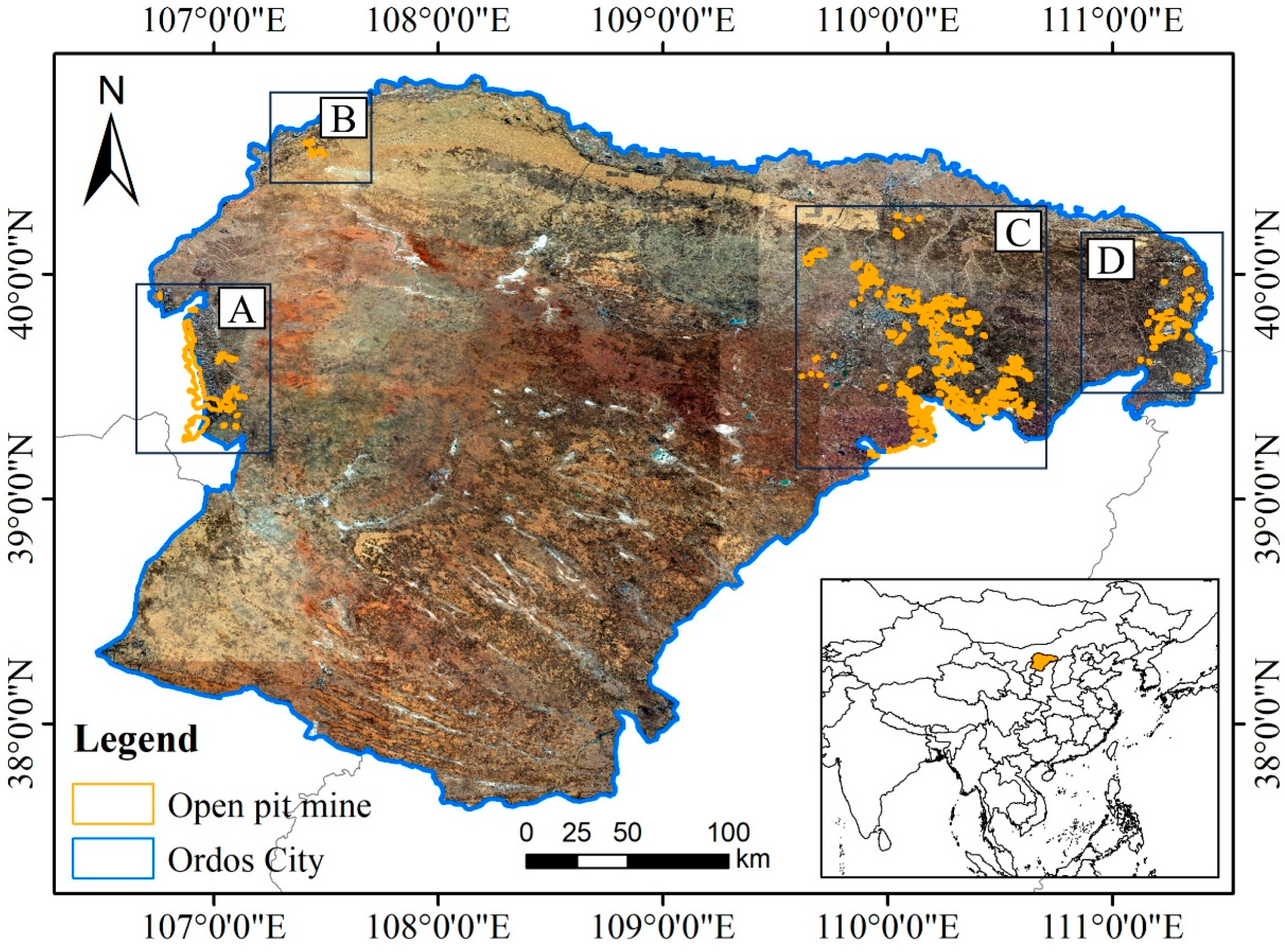
2.1. Study Area

Ordos City is situated in the Inner Mongolia Autonomous Region of China, lying between latitude 37°35′24″~40°51′40″ north and longitude 106°42′40″~111°27′20″ east, with a total area of 87,000 square kilometers [22,23,24]. Figure 1 shows the geographic location of Ordos City and its spatial distribution of open-pit mining areas. Ordos City has abundant mining energy, with 167.6 billion tons of proven coal reserves, which is one sixth of the country’s total [25,26].
However, due to the exploitation of coal energy, Ordos City is also facing a series of environmental problems. For example, the combustion of coal releases a large number of pollutants such as carbon dioxide, sulfur dioxide, and particulate matter, which have a significant impact on the quality of the atmosphere [27,28]. Solid waste such as coal gangue and coal ash generated during coal mining and utilization may lead to soil pollution and further affect farmland and ecosystems if not handled properly [29,30,31]. The discharge of coal dust, wastewater, and other waste may lead to the poisoning and death of nearby vegetation, further exacerbating ecological problems. Monitoring land-cover types and their changes in open-pit mining areas is not only essential for ecological protection, but also helps to assess the impacts of coal mining on vegetation and the ecological restoration needs that may be triggered [32,33]. It can help us to assess the ecological condition of the mining area, and identify and correct potential environmental problems in time. In this regard, it has an important impact on the provision of ecosystem services and is an important basis for sustainable development planning in mining areas [34,35]. Furthermore, it provides a basis for assessing the disaster risk of the mining area and providing early warning of possible disasters [36,37].

2.2. Data

The boundaries of the open-pit mining area in Ordos City were obtained using version 1 of the global-scale mining polygon. It contains over 21,000 polygons of mining-related activities, mainly coal and metal ores [38]. The derived polygons cover land directly used by mining activities, including open-pit mining, tailings dams, waste rock dumps, ponds, and processing infrastructure. Sentinel-2 remote sensing images, collected from January to December 2019 and January to December 2022, are used to synthesize a view every two months. The bands of the images utilized are the Red, Green, Blue, Red Edge 1, Red Edge 2, Red Edge 3, Red Edge 4, Near Infrared, Short-wavelength Infrared 1, and Short-wavelength Infrared 2 bands.

2.3. Methods

The framework of this study is shown in Figure 2. Combined with the band information, the temporal–spectral feature information is constructed by calculating the NDVI, NDWI, NDBI, RVI, and EVI of the images in the open-pit mining area. The corresponding training samples and validation samples of the mining area are selected, and the multidimensional feature information is extracted for classification using the random forest method to obtain the land-cover classification results in the open-pit mining area.

2.3.1. Acquisition of Temporal–Spectral Features in Remote Sensing Images

The derived features are calculated using the bands of the remote sensing images, i.e., the normalized difference vegetation index (NDVI) [39], the normalized difference water index (NDWI) [40], the normalized difference built-up index (NDBI) [41], the radar vegetation index (RVI) [42], and the enhanced vegetation index (EVI) [43]. The Sentinel 2 data are synthesized for each 2-month period and the 10 m and 20 m band information from the images are combined with the calculated derived features to obtain 90 features per year. The formulae for the derived features are as follows:
N D V I = ( N I R R e d ) ( N I R + R e d )
N D W I = ( G r e e n N I R ) ( G r e e n + N I R )
N D B I = ( M I R N I R ) ( M I R + N I R )
R V I = N I R R e d
E V I = 2.5 × N I R R e d N I R + 6 × R e d 7.5 × B l u e + 1
where G r e e n , B l u e   R e d , N I R , and M I R denote the corresponding remote sensing image bands.

2.3.2. Determination of Land-Cover Types Based on Random Forest

The random forest method [44] is a commonly used method for land-cover classification. The principle of this method is as follows: first, random sampling with putback is performed from the training data to generate multiple random training subsets. Second, the decision tree splits the samples according to the different features, generates a series of nodes and branches, and finally realizes the classification of the samples. Then, in the process of constructing the decision tree, each split is selected based on a random subset of features. This ensures that each decision tree is different from each other and increases the diversity of the model. Finally, when a new sample arrives, the random forest feeds that sample into each decision tree for classification. Each decision tree votes to give its own classification, and the random forest ultimately chooses the classification with the most votes as the final prediction.
The land-cover types in the study area include vegetation, bare land, coal, water bodies, and building land. Vegetation refers to the land in the mining area that is covered by plants, including natural vegetation and artificially planted vegetation. Vegetation can comprise different types of plant communities such as grassland, forest, scrubland, etc. Bare land means the land cover within a mine site that is not covered by vegetation and is usually exposed as bare soil or rock. Coal means the type of land cover created by the extraction of coal within a mine site. This type may include exposed coal dumps, pits, or mine excavation faces. Water bodies are the types of water cover within a mine site, including lakes, reservoirs, rivers, and ponds. Building land refers to the type of land cover used within a mine site for the construction of human-made buildings and sites such as facilities, office buildings, roads, warehouses, vehicle parking, etc.
In this study, for the random forest classification, we selected 134 pixels as building land training samples, 787 pixels as vegetation training samples, 565 pixels as bare land training samples, 409 pixels as coal training samples, and 95 pixels as water body training samples for the 2019 remote sensing image data. For the 2022 remote sensing image data, 171 pixels were selected for the building land training sample, 299 pixels for the vegetation training sample, 340 pixels for the bare land training sample, 183 pixels for the coal training sample, and 111 pixels for the water body training sample. On this basis, the overall accuracy and kappa coefficient were adopted as the accuracy evaluation indexes of land-cover classification results.

2.3.3. Calculation of Changes in Land-Cover Types

Changes in land-cover types can be obtained and evaluated from the land-cover type change rate and the land-cover change transfer matrix. The land-cover type change rate is an indicator used to assess the change of land-cover types between years. The land-cover change transfer matrix offers a quantitative picture of changes in land-cover types over time in the same area [45,46]. The specific formula is as follows.
c h a n g e   r a t e = A b A a A a × 100 %
where A a and A b are the areas of land cover types corresponding to years a and b , respectively.
s i j = s 11 s 12           s 1 n s 21 s 22           s 2 n                                           s n 1 s n 2           s n n
where s is the land cover area; n is the number of land cover types; i and j are the land cover types before and after conversion, respectively; s i j is the area converted from land type i to land type j .

3. Results

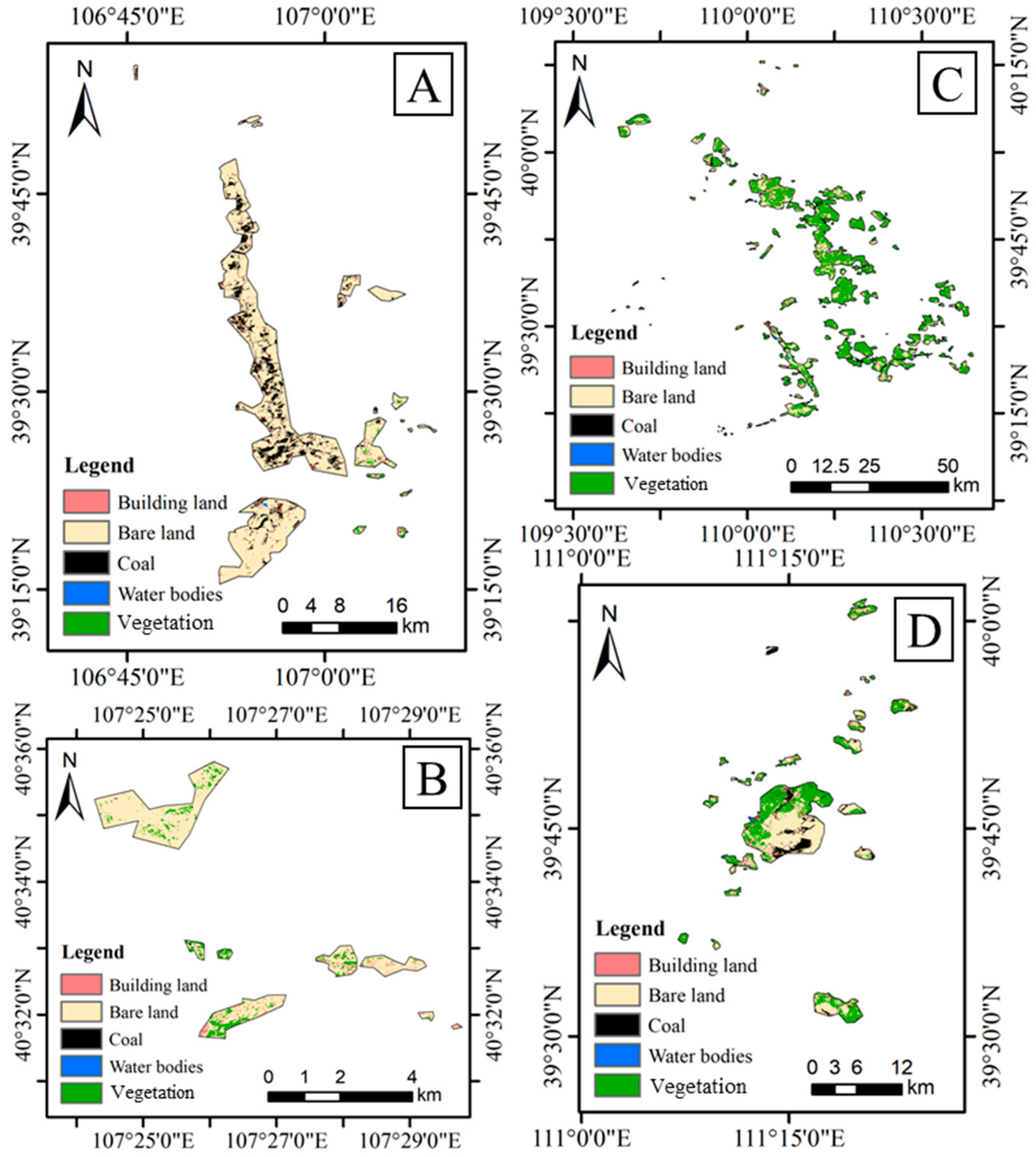
3.1. Land-Cover Types for Open-Pit Mining Areas in Ordos City, 2019

Figure 3 shows the spatial distribution of land-cover types in the open-pit mining areas of Ordos City in 2019. Subarea A is located in the western part of Ordos City, and its main land-cover types are bare land and coal, along with a small amount of building land, with very few water bodies and little vegetation. Subarea B is located in the northern part of Ordos City, and its main land-cover types are bare land and vegetation, alongside a small amount of building land. Subarea C is located in the central-eastern part of Ordos City, and its main land-cover types are vegetation and building land. Subarea D is located in the eastern part of Ordos City, and its main land-cover types include vegetation, a small amount of bare land, and building land.
As shown in Table 1, the total area of the open-pit mining area in Ordos City is 1323.52 km2. Of this, 9.82 km2 or 0.74% is building land, 576.59 km2 or 43.57% is bare land, 631.80 km2 or 47.74% is vegetation, 100.93 km2 is coal, and 4.37 km2 comprises water bodies. Vegetation was the land-cover type occupying the largest share of the open-pit mining area in 2019, followed by bare land; water bodies are the land-cover type with the smallest share of the area.

3.2. Land-Cover Types for Open-Pit Mining Areas in Ordos City, 2022

As shown in Figure 4, the spatial distribution of land-cover types in the open-pit mining area in Ordos City in 2022 is basically the same as that in 2019. The predominant land-cover types in subarea A are still bare land and coal. The predominant land-cover types in subarea B are bare land and vegetation. Subarea C largely comprises vegetation. The predominant land-cover types in subarea D are also bare land, vegetation, and coal. It can be seen that vegetation has increased significantly between 2019 and 2022.
Table 2 shows the area and percentage of land-cover types in surface mining areas in 2022. It is clear that the area of vegetation accounts for 49.31% of the total area of the mine, with an area of 652.67 km2. The next largest area is bare land, with an area of 519.91 km2, accounting for 39.28%. Water bodies are the smallest, accounting for only 0.25% of the total area, with an area of 3.34 km2. The areas of building land and coal are 59.24 km2 and 88.35 km2, respectively.

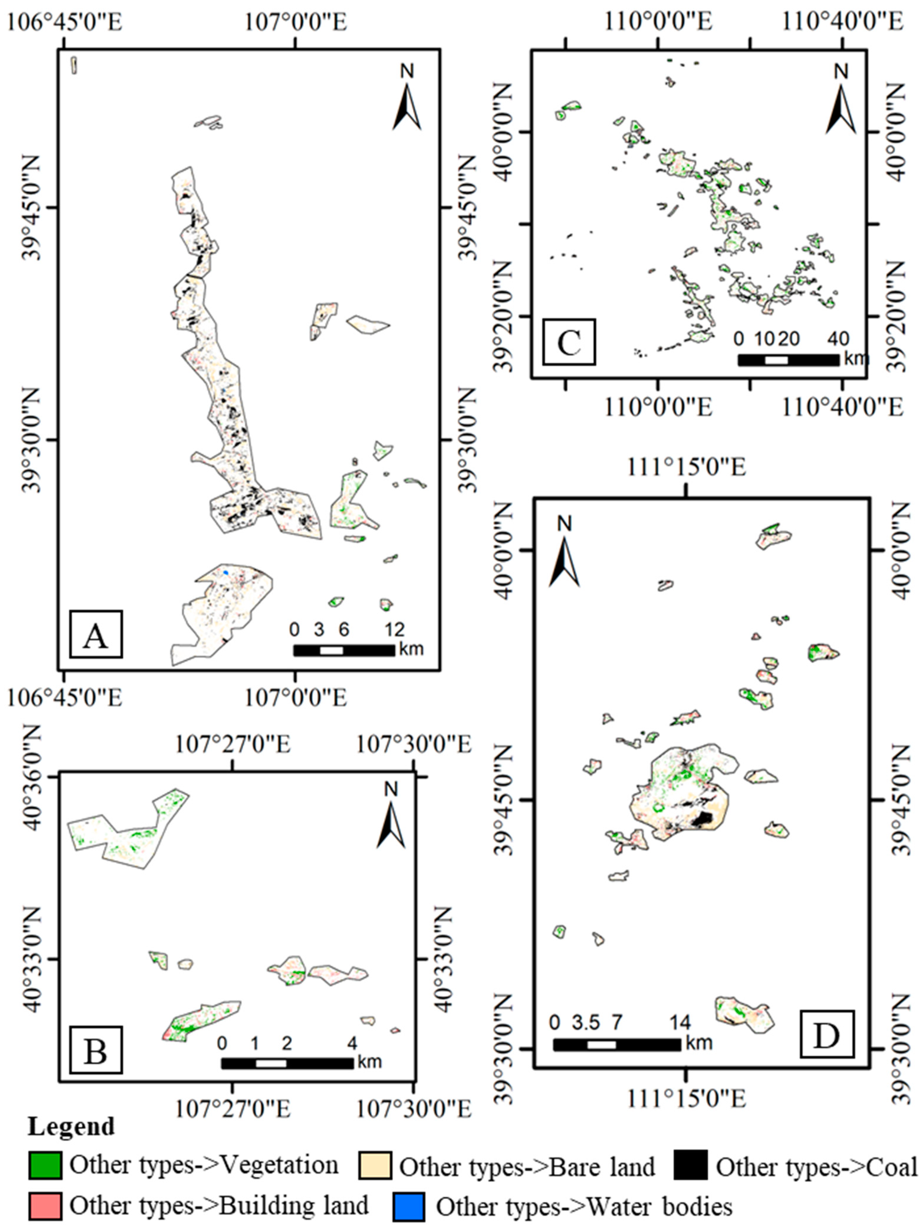
3.3. Changes in the Land Cover of Open-Pit Mining Areas in Ordos City, 2019–2022

Table 3 shows the amount and rate of change of land-cover types in the open-pit mining area of Ordos City between 2019 and 2022. Vegetation and building land present an increasing trend, bare land, and coal exhibit a decreasing trend, and water bodies show a slight decrease. Specifically, the area of coal and bare land decreased by 12.58 km2 and 56.68 km2, respectively, and the area of building land and vegetation increased by 49.42 km2 and 20.87 km2, respectively.
Table 4 shows the land-cover change transfer matrix for open-pit mining areas. During the period from 2019 to 2022, bare land was mainly converted to vegetation, building land, and coal, with areas of 121.24 km2, 25.82 km2, and 35.32 km2 respectively. The area of building land converted to other land-cover types in 2019 is insignificant. Coal was mainly converted to bare land, with an area of 46.45 km2 converted. A smaller area of water bodies was converted to other land-cover types in 2019. Vegetation was mainly converted to bare land, with an area of 77.10 km2, followed by conversion to built-up land with an area of 19.79 km2. Figure 5 shows the spatial distribution of land-cover type changes in 2019 and 2022. Subarea A primarily experienced the conversion of other land-cover types to coal and a small amount of the conversion of other land-cover types to building land during the period from 2019–2022. Subarea B primarily experienced changes in the conversion of other land-cover types to vegetation and bare land, as well as a small amount of other land-cover types being converted to building land. Subarea C, like subarea B, mainly experienced the conversion of other land-cover types to vegetation and bare land. Subarea D primarily experienced the conversion of other land-cover types to coal, bare land, restored land, and a small amount of building land.

4. Discussion

4.1. Evaluation of Land-Cover Type Accuracy

In order to verify the accuracy of the 2019 and 2022 land-cover type results, we selected 3675 pixels of building land validation samples, 3863 pixels of water body validation samples, 41,014 pixels of vegetation validation samples, 10,491 pixels of coal validation samples, and 31,073 pixels of bare land validation samples for the 2019 land-cover type results. The land-cover type results for 2022 were selected from a 5770-pixel building land validation sample, a 5516-pixel water body validation sample, a 68,931-pixel vegetation validation sample, a 22,057-pixel coal validation sample, and a 44,921-pixel bare land validation sample. The overall accuracy and kappa coefficients were used to evaluate the results of land-cover type for 2019 and 2022 [47,48,49].
Table 4 shows the accuracy evaluation of the results of land-cover types for 2019 and 2022. The overall accuracy of the assessments of the land-cover types of the open-pit mining area in 2019 was 94.32%, with a kappa coefficient of 0.91. The overall accuracy of the assessment of the land-cover types of the open-pit mining area in 2022 was 95.19%, with a kappa coefficient of 0.92. As shown in Figure 6, combined with the Sentinel-2 data, the results of land-cover types and their changes in the open-pit mining area for 2019 and 2022 exhibit a high level of accuracy.

4.2. Recommendations for the Governance of Mining Areas in Ordos City

According to the above land-cover classification results and their changes, it is clear that study area A mainly comprises bare land and coal. Measures can be taken to facilitate ecological restoration and vegetation recovery, including replanting vegetation, carrying out soil improvements, and implementing ecological projects, in order to promote ecosystem recovery and the growth of vegetation in the mining area [50,51]. On this basis, land reuse can be carried out, such as agricultural, forestry, or sightseeing and tourism activities, producing economic, social, and ecological benefits. Furthermore, land-use patterns can be identified and optimized, comprehensive resource utilization can be implemented, and agricultural modernization can be promoted in order to maximize the benefits of the land. Study area A and study area D have more obvious coal. The coal mining methods in this area can be adjusted and the environmental and geological conditions improved, such as by adopting more advanced mining technologies, strengthening environmental protection and governance, and promoting green mining, in order to reduce environmental pollution and ecological damage. In addition, the sustainable development of the mining area will be promoted by advancing clean energy, implementing energy savings and emissions reduction, and implementing a circular economy.
Combined with the relevant policy documents of Ordos City, in order to achieve the sustainable development of mines, the following aspects can be considered. (1) The concept of green mines should be taken into consideration in mine planning. By conducting scientific and rational mine development and management, their impact on the environment can be minimized. This can include reducing land damage, protecting water resources, and undertaking waste management and energy conservation [52,53,54]. (2) A comprehensive ecological restoration plan should be established to restore the ecosystems affected by mining activities. The plan should include measures such as vegetation restoration, soil remediation, and water management, in order to promote the growth of vegetation and biodiversity recovery. (3) Reasonable waste management strategies should be formulated, including ore treatment, waste classification and treatment, and reuse. The pollution of soil and water by waste must be reduced and the utilization of resources should be maximized. (4) The protection and management of water resources should be strengthened and the consumption and pollution of water bodies by mining activities reduced [55,56]. A rational water resource management system should be established, monitored, and managed to ensure a sustainable water supply and improved water quality. (5) Energy-saving and environmentally friendly technologies and equipment should be adopted in the mining and production processes to reduce energy consumption and emissions. Clean energy sources, such as solar and wind energy, should be promoted to reduce dependence on traditional energy sources.

4.3. Limitations and Future Work

In this study, the temporal, spectral, and derived features of Sentinel-2 images are used to extract the land-cover types in the open-pit mining area of Ordos City; although decent land-cover classification accuracy is achieved, the following problems still exist. First, obtaining the results of land-cover types from the pixel perspective may still lead to the phenomenon of “salt and pepper” [57,58,59,60]. Therefore, further research should consider acquiring the land-cover types of mining areas from an object-oriented perspective to improve the accuracy of the classification results. Second, the maximum resolution of Sentinel-2 images is 10 m, which is relatively low compared to other high-resolution remote sensing images, although it is easy to obtain. Therefore, further studies should consider using higher-resolution remote sensing images to obtain more detailed land-cover types in mining areas. Finally, our assessment of the change in the land-cover types in mining areas does not consider the driving factors. Therefore, further research will explore the reasons influencing land-cover type changes from the perspectives of both natural and anthropogenic factors.

5. Conclusions

This paper explores the use of Sentinel-2 data to assess land-cover types and their changes in the open-pit mining area of Ordos City in 2019 and 2022. The corresponding land-cover types and their changes are obtained by acquiring the temporal features, spectral features, and the derived features from the images, combined with the random forest method. The specific conclusions are as follows.
(1) During the period from 2019 to 2022, the land-cover types of the open-pit mining areas in Ordos City included building land, bare land, water bodies, vegetation, and coal. The main land-cover types in the open-pit mining areas in the western part of Ordos City are bare land and coal, as well as a small amount of vegetation. The predominant land-cover types in the open-pit mining areas in the eastern part of Ordos City are vegetation and a small amount of bare land and coal.
(2) The two land-cover types that account for the largest share of the open-pit mining area in Ordos City from 2019 to 2022 are vegetation and bare land, which account for about 88–91% of the overall area, followed by coal, which accounts for about 6–7% of the overall area.
(3) The main land-cover type changes in the open-pit mining area in Ordos City from 2019 to 2022 are the conversion of bare land to vegetation, the conversion of coal to bare land, and the conversion of vegetation to bare land.
(4) Making full use of the temporal features, spectral features, and their derived features within the year provides decent results for land-cover types. It provides a feasible path for exploring the land-cover types and their changes in open-pit mining areas, facilitating the sustainable development and ecological environmental protection of the mining area.

Author Contributions

Conceptualization, L.Z. and Y.Z.; methodology, L.Z. and K.C.; software, L.Z., and W.S.; writing—original draft preparation, L.Z.; writing—review and editing, Y.Z., K.C., Q.L. and W.S. All authors have read and agreed to the published version of the manuscript.

Funding

This study is funded by the Ordos City Landmark Team Project, the key program of the National Natural Science Foundation of China (grant number 41930650), and the general program of the National Natural Science Foundation of China (grant number 42271435).

Institutional Review Board Statement

Not applicable.

Informed Consent Statement

Not applicable.

Data Availability Statement

Not applicable.

Acknowledgments

The authors would like to thank the editors and the anonymous reviewers for their constructive comments and suggestions, which greatly helped to improve the quality of the manuscript.

Conflicts of Interest

The authors declare no conflict of interest.

References

  1. Haidai, O.; Ruskykh, V.; Ulanova, N.; Prykhodko, V.; Cabana, E.C.; Dychkovskyi, R.; Howaniec, N.; Smolinski, A. Mine Field Preparation and Coal Mining in Western Donbas: Energy Security of Ukraine—A Case Study. Energies 2022, 15, 4653. [Google Scholar] [CrossRef]
  2. Hamilton, C.; Song, J.; Cui, R.; Olson, C.; Cui, D. Evaluating provincial-level employment challenge during the coal transition in China. Adv. Clim. Chang. Res. 2022, 13, 729–737. [Google Scholar] [CrossRef]
  3. Hower, J.C.; Finkelman, R.B.; Eble, C.F.; Arnold, B.J. Understanding coal quality and the critical importance of comprehensive coal analyses. Int. J. Coal Geol. 2022, 263, 104120. [Google Scholar] [CrossRef]
  4. Ponnudurai, V.; Senthil Kumar, P.; Sankar Muthuvelu, K.; Velmurugan, S.; Subhani, S.; Arumugam, L.; Rajarathinam, R. Investigation on future perspectives of ex-situ biogenic methane generation from solid waste coal and coal washery rejects. Fuel 2022, 318, 123497. [Google Scholar] [CrossRef]
  5. Kacker, K.; Lange, I. Inter-regional coal mine competition in the US: Evidence from rail restrictions. Energy Econ. 2022, 110, 105998. [Google Scholar] [CrossRef]
  6. Zhu, L.; Xing, H.; Hou, D. Analysis of carbon emissions from land cover change during 2000 to 2020 in Shandong Province, China. Sci. Rep. 2022, 12, 8021. [Google Scholar] [CrossRef]
  7. Zhu, L.; Shi, M.; Fan, D.; Tu, K.; Sun, W. Analysis of Changes in Vegetation Carbon Storage and Net Primary Productivity as Influenced by Land-Cover Change in Inner Mongolia, China. Sustainability 2023, 15, 4735. [Google Scholar] [CrossRef]
  8. Zhu, L.; Sun, W.; Wu, J.; Fan, D. Spatiotemporal Distribution of Carbon Sink Indicators—NPP and Its Driving Analysis in Ordos City, China. Appl. Sci. 2023, 13, 6457. [Google Scholar] [CrossRef]
  9. Dewan, A.; Kabir, M.H.; Nahar, K.; Rahman, Z. Urbanisation and environmental degradation in Dhaka Metropolitan Area of Bangladesh. Int. J. Environ. Sustain. Dev. 2012, 11, 118–147. [Google Scholar] [CrossRef]
  10. Zhong, C.; Guo, H.; Swan, I.; Gao, P.; Yao, Q.; Li, H. Evaluating trends, profits, and risks of global cities in recent urban expansion for advancing sustainable development. Habitat Int. 2023, 138, 102869. [Google Scholar] [CrossRef]
  11. Xia, B.; Kong, F.; Zhou, J.; Wu, X.; Xie, Q. Land Resource Use Classification Using Deep Learning in Ecological Remote Sensing Images. Comput. Intell. Neurosci. 2022, 2022, 7179477. [Google Scholar] [CrossRef] [PubMed]
  12. Guan, R.; Li, Z.; Li, T.; Li, X.; Yang, J.; Chen, W. Classification of Heterogeneous Mining Areas Based on ResCapsNet and Gaofen-5 Imagery. Remote Sens. 2022, 14, 3216. [Google Scholar] [CrossRef]
  13. Liu, Y.; Zhang, J. A lightweight convolutional neural network based on dense connection for open-pit coal mine service identification using the edge-cloud architecture. J. Cloud Comput. 2023, 12, 32. [Google Scholar] [CrossRef]
  14. Hai, W.; Xia, N.; Song, J.; Tang, M. Identification and Monitoring of Surface Elements in Open-Pit Coal Mine Area Based on Multi-Source Remote Sensing Images. Pol. J. Environ. Stud. 2022, 31, 4127–4136. [Google Scholar] [CrossRef]
  15. Tang, H.; Fang, J.; Xie, R.; Ji, X.; Li, D.; Yuan, J. Impact of Land Cover Change on a Typical Mining Region and Its Ecological Environment Quality Evaluation Using Remote Sensing Based Ecological Index (RSEI). Sustainability 2022, 14, 12694. [Google Scholar] [CrossRef]
  16. Hong, F.; He, G.; Wang, G.; Zhang, Z.; Peng, Y. Monitoring of Land Cover and Vegetation Changes in Juhugeng Coal Mining Area Based on Multi-Source Remote Sensing Data. Remote Sens. 2023, 15, 3439. [Google Scholar] [CrossRef]
  17. Su, X.; Qian, Z. Neoliberal planning, master plan adjustment and overbuilding in China: The case of Ordos City. Cities 2020, 105, 102748. [Google Scholar] [CrossRef]
  18. Zhang, H.; Guo, J.; Li, X.; Liu, Y.; Wang, T. Spatiotemporal Variation in and Responses of the NDVI to Climate in Western Ordos and Eastern Alxa. Sustainability 2023, 15, 4375. [Google Scholar] [CrossRef]
  19. Pan, W.; Li, Y.; Zhang, C.; Shi, X.; Cui, H.; Wang, B.; Li, Y.; Wang, Y. Coal Burst Prevention Technology and Engineering Practice in Ordos Deep Mining Area of China. Sustainability 2023, 15, 159. [Google Scholar] [CrossRef]
  20. Ao, Z.; Wang, Z.; Zhou, W.; Qiao, Y.; Wahab, A.; Yang, Z.; Nie, S.; Liu, Z.; Zhu, L. CFD Simulation Based Ventilation and Dust Reduction Strategy for Large Scale Enclosed Spaces in Open Pit Coal Mines—A Case of Coal Shed. Sustainability 2023, 15, 11651. [Google Scholar] [CrossRef]
  21. Zhang, B.; Zhang, R.; Han, P.-F.; Wang, J.; Wan, L. Evolution of Hydrogeochemistry in the Haolebaojinao Watershed of the Ordos Basin, China. Sustainability 2023, 15, 5091. [Google Scholar] [CrossRef]
  22. Li, J. Responses of Vegetation NDVI to Climate Change and Land. Appl. Sci. 2022, 12, 7288. [Google Scholar] [CrossRef]
  23. Wang, Z.; Hasi, E. Research on the Development of Deserticulture and Desertification Land Use Benefits Evaluation in Ordos City. Land 2023, 12, 1254. [Google Scholar] [CrossRef]
  24. Su, X.; Qian, Z. Neoliberal financial governance and its transformation under real estate boom and bust: The case of Ordos City, China. Land Use Policy 2022, 112, 104728. [Google Scholar] [CrossRef]
  25. Li, J.; Ma, Z.; Sun, H.; Chen, W. Driving factor analysis and dynamic forecast of industrial carbon emissions in resource-dependent cities: A case study of Ordos, China. Environ. Sci. Pollut. Res. 2023, 30, 92146–92161. [Google Scholar] [CrossRef]
  26. Fang, Z.; Ding, T.; Chen, J.; Xue, S.; Zhou, Q.; Wang, Y.; Wang, Y.; Huang, Z.; Yang, S. Impacts of land use/land cover changes on ecosystem services in ecologically fragile regions. Sci. Total Environ. 2022, 831, 154967. [Google Scholar] [CrossRef]
  27. Rashid, M.; Isah, U.; Athar, M.; Benhelal, E. Energy and Chemicals Production from Coal-based Technologies: A Review. ChemBioEng Rev. 2023. early view. [Google Scholar] [CrossRef]
  28. Shah, A.A.; Usto, A.; Ahmed, T.; Jatoi, A.; Hashmi, Z.; Chandio, Z.; Ahmed, S.; Iqbal, A.; Siyal, S.; Shah, A. Facile application of used engine oil in high sulfur coal briquetting to reduce the hazardous emission gases. Int. J. Coal Prep. Util. 2022, 43, 1139–1151. [Google Scholar] [CrossRef]
  29. Iglauer, S.; Akhondzadeh, H.; Abid, H.; Paluszny, A.; Keshavarz, A.; Ali, M.; Giwelli, A.; Esteban, L.; Sarout, J.; Lebedev, M. Hydrogen Flooding of a Coal Core: Effect on Coal Swelling. Geophys. Res. Lett. 2022, 49, e2021GL096873. [Google Scholar] [CrossRef]
  30. Ren, J.; Ashida, R.; Kawase, M.; Sakai, K.; Okuyama, N. Development of a Novel Mild Depolymerization Method of Coal by Combining Oxygen Oxidation and Formic Acid Reduction Reactions. ACS Omega 2023, 8, 2531–2537. [Google Scholar] [CrossRef]
  31. Labzovskii, L.D.; Belikov, D.A.; Damiani, A. Spaceborne NO2 observations are sensitive to coal mining and processing in the largest coal basin of Russia. Sci. Rep. 2022, 12, 12597. [Google Scholar] [CrossRef] [PubMed]
  32. Martus, E.; Fortescue, S. Russian coal in a changing climate: Risks and opportunities for industry and government. Clim. Chang. 2022, 173, 26. [Google Scholar] [CrossRef]
  33. Gosens, J.; Turnbull, A.B.H.; Jotzo, F. China’s decarbonization and energy security plans will reduce seaborne coal imports: Results from an installation-level model. Joule 2022, 6, 782–815. [Google Scholar] [CrossRef]
  34. Mukherjee, T.; Gupta, A.; Deodhar, A.; Runkana, V. Real-time coal classification in thermal power plants. Control Eng. Pract. 2023, 130, 105377. [Google Scholar] [CrossRef]
  35. Roy, P.; Hossain, M.N.; Uddin, S.M.M.; Hossain, M.M. Unraveling the sustainability aspects of coal extraction and use in Bangladesh using material flow analysis and life cycle assessment. J. Clean. Prod. 2023, 387, 135895. [Google Scholar] [CrossRef]
  36. Sinha, S.K.; Srikanth, R.; Mahalingam, S. Regulatory framework for India’s energy security and sustainability. Energy Policy 2022, 162, 112815. [Google Scholar] [CrossRef]
  37. Santiago, V.; Guerrero Zabala, F.; Sanchez-Barra, A.J.; Deisman, N.; Chalaturnyk, R.J.; Zhong, R.; Hurter, S. Experimental investigation of the flow properties of layered coal-rock analogues. Chem. Eng. Res. Des. 2022, 186, 685–700. [Google Scholar] [CrossRef]
  38. Maus, V.; Giljum, S.; Gutschlhofer, J.; da Silva, D.M.; Probst, M.; Gass, S.L.B.; Luckeneder, S.; Lieber, M.; McCallum, I. Global-scale mining polygons (Version 1). PANGAEA 2020. [Google Scholar] [CrossRef]
  39. Zhu, L.; Xing, H.; Zhao, L.; Qu, H.; Sun, W. A change type determination method based on knowledge of spectral changes in land cover types. Earth Sci. Inform. 2023, 16, 1265–1279. [Google Scholar] [CrossRef]
  40. Jin, S.; Liu, Y.; Fagherazzi, S.; Mi, H.; Qiao, G.; Xu, W.; Sun, C.; Liu, Y.; Zhao, B.; Fichot, C.G. River body extraction from sentinel-2A/B MSI images based on an adaptive multi-scale region growth method. Remote Sens. Environ. 2021, 255, 112297. [Google Scholar] [CrossRef]
  41. Data, S. Analysis of the Spatial and Temporal Pattern of Changes in Abandoned Farmland Based on Long Time Series of Remote Sensing Data. Remote Sens. 2021, 13, 2549–2568. [Google Scholar]
  42. Zhu, L.; Jiang, X.; Zhao, L.; Qu, H.; Sun, W. A temporal-spectral value and shape change detection method integrating thematic index information and spectral band information. Environ. Sci. Pollut. Res. 2023, 30, 47408–47421. [Google Scholar] [CrossRef] [PubMed]
  43. Khabbazan, S.; Steele-Dunne, S.C.; Vermunt, P.; Judge, J.; Vreugdenhil, M.; Gao, G. The influence of surface canopy water on the relationship between L-band backscatter and biophysical variables in agricultural monitoring. Remote Sens. Environ. 2022, 268, 112789. [Google Scholar] [CrossRef]
  44. Zhu, L.; Guo, Z.; Xing, H.; Sun, W. A coupled temporal-spectral-spatial multidimensional information change detection framework method: A case of the 1990–2020 Tianjin, China. IEEE J. Sel. Top. Appl. Earth Obs. Remote Sens. 2023, 16, 5741–5758. [Google Scholar] [CrossRef]
  45. Mugiraneza, T.; Hafner, S.; Haas, J.; Ban, Y. Monitoring urbanization and environmental impact in Kigali, Rwanda using Sentinel-2 MSI data and ecosystem service bundles. Int. J. Appl. Earth Obs. Geoinf. 2022, 109, 102775. [Google Scholar] [CrossRef]
  46. Ghazali, E.; Johari, M.A.M.; Fauzi, M.A.; Nor, N.M. An Overview of Characterisation, Utilisation, and Leachate Analysis of Clinical Waste Incineration Ash. Int. J. Environ. Res. 2022, 16, 69. [Google Scholar] [CrossRef]
  47. Yang, B.; Qin, L.; Liu, J.; Liu, X. UTRNet: An Unsupervised Time-Distance-Guided Convolutional Recurrent Network for Change Detection in Irregularly Collected Images. IEEE Trans. Geosci. Remote Sens. 2022, 60, 4410516. [Google Scholar] [CrossRef]
  48. Zhu, S.; Song, Y.; Zhang, Y.; Zhang, Y. ECFNet: A Siamese Network With Fewer FPs and Fewer FNs for Change Detection of Remote-Sensing Images. IEEE Geosci. Remote Sens. Lett. 2023, 20, 6001005. [Google Scholar] [CrossRef]
  49. Nguyen, L.H.; Joshi, D.R.; Clay, D.E.; Henebry, G.M. Characterizing land cover/land use from multiple years of Landsat and MODIS time series: A novel approach using land surface phenology modeling and random forest classifier. Remote Sens. Environ. 2020, 238, 111017. [Google Scholar] [CrossRef]
  50. Yanguas-Parra, P.A.; Malz, N.; Oei, P.-Y.; Furnaro, A.; Hauenstein, C.; Quiceno, G.; Corral-Montoya, F.; Mitterecker, T.; Hanto, J. Perspective: How a short-term relapse to coal could put exporting countries and just transition processes at risk. Energy Res. Soc. Sci. 2023, 97, 102989. [Google Scholar] [CrossRef]
  51. Arnold, B.J. A review of element partitioning in coal preparation. Int. J. Coal Geol. 2023, 274, 104296. [Google Scholar] [CrossRef]
  52. Patria, A.A.; Anggara, F. Petrological, mineralogical, and geochemical compositions of coal in the Ombilin Basin, West Sumatra, Indonesia. Int. J. Coal Geol. 2022, 262, 104099. [Google Scholar] [CrossRef]
  53. Cakmak, E.; Hower, J.C.; Mathews, J.P.; Weisenberger, M.C.; Kaplan, R.; Lacy, J.; Zhang, Y.; Lara-Curzio, E. Microstructural diversity and digestion yields of select bituminous and subbituminous coals as raw material candidates for carbon fiber precursor production. Fuel 2023, 348, 128545. [Google Scholar] [CrossRef]
  54. Delina, L.L. Coal development and its discontents: Modes, strategies, and tactics of a localized, yet networked, anti-coal mobilisation in central Philippines. Extr. Ind. Soc. 2022, 9, 101043. [Google Scholar] [CrossRef]
  55. Azam, S.; Liu, S.; Bhattacharyya, S.; Liu, A. Measurement and modeling of water vapor sorption on nano-sized coal particulates and its implication on its transport and deposition in the environment. Sci. Total Environ. 2023, 889, 164095. [Google Scholar] [CrossRef]
  56. Michieka, N.M.; Graziano, M.; Musso, M.; Fouquet, R. Energy transitions and labor market patterns in the U.S. coal industry. Struct. Chang. Econ. Dyn. 2022, 63, 501–514. [Google Scholar] [CrossRef]
  57. Manzoni, M.; Monti-Guarnieri, A.; Molinari, M.E. Joint exploitation of spaceborne SAR images and GIS techniques for urban coherent change detection. Remote Sens. Environ. 2021, 253, 112152. [Google Scholar] [CrossRef]
  58. Saha, S.; Member, S.; Solano-correa, Y.T.; Bovolo, F.; Member, S.; Bruzzone, L. Unsupervised Deep Transfer Learning-Based Change Detection for HR Multispectral Images. IEEE Geosci. Remote Sens. Lett. 2020, 99, 856–860. [Google Scholar] [CrossRef]
  59. Slingsby, J.A.; Moncrieff, G.R.; Wilson, A.M. Near-real time forecasting and change detection for an open ecosystem with complex natural dynamics. ISPRS J. Photogramm. Remote Sens. 2020, 166, 15–25. [Google Scholar] [CrossRef]
  60. Ballère, M.; Bouvet, A.; Mermoz, S.; Le Toan, T.; Koleck, T.; Bedeau, C.; André, M.; Forestier, E.; Frison, P.L.; Lardeux, C. SAR data for tropical forest disturbance alerts in French Guiana: Benefit over optical imagery. Remote Sens. Environ. 2021, 252, 112159. [Google Scholar] [CrossRef]
Figure 1. Spatial distribution of open-pit mining areas in Ordos City.
Sustainability 15 14053 g001
Figure 2. Flowchart of this study.
Sustainability 15 14053 g002
Figure 3. Land-cover types for open-pit mining areas in Ordos City, 2019. (A) The predominant land-cover types in study area A are coal and bare land. (B) The main land-cover types in study area B include vegetation and bare land. (C) Vegetation is the dominant land-cover type in study area C. (D) In study area D, vegetation, bare land, and coal are the prevailing land-cover types.
Sustainability 15 14053 g003
Figure 4. Land-cover types for open-pit mining areas in Ordos City, 2022. (AD) have bare land, coal, and vegetation as their main land-cover types, respectively.
Sustainability 15 14053 g004
Figure 5. Land-cover changes for open-pit mining areas in Ordos City.
Sustainability 15 14053 g005
Figure 6. Localized results for land-cover types and their changes.
Sustainability 15 14053 g006
Table 1. Area and percentage of land-cover types in open-pit mining areas in Ordos City, 2019.
Land-Cover TypesBuilding LandBare LandCoal Water BodiesVegetation
Area/km29.82576.59100.934.37631.80
Proportion/%0.7443.577.630.3347.74
Table 2. Area and percentage of land-cover types in open-pit mining areas in Ordos City, 2022.
Land-Cover TypesBuilding LandBare LandCoal Water BodiesVegetation
Area/km259.24519.9188.353.34652.67
Proportion/%4.4839.286.680.2549.31
Table 3. Land-cover type change rate in open-pit mining areas in Ordos City.
Land-Cover TypesBuilding LandBare LandCoal Water BodiesVegetation
Amount of change/km249.42−56.68−12.58−1.0320.87
Rate of change/%503.14−9.83−12.46−23.503.30
Table 4. Land-cover-change transfer matrix and accuracy evaluation results in open-pit mining areas in Ordos City.
Area/km2Building LandBare LandCoal Water BodiesVegetationTotal 2022
Building land6.7325.82 6.73 0.16 19.79 59.24
Bare land1.54 393.93 46.45 0.90 77.10 519.91
Coal 0.08 35.32 40.32 0.53 12.10 88.35
Water bodies0.00 0.29 0.37 2.66 0.02 3.34
Vegetation1.48 121.24 7.05 0.12 522.78 652.67
Total 20199.82 576.59 100.93 4.37 631.80 1323.52
YearOverall accuracy/%Kappa
201994.320.91
Disclaimer/Publisher’s Note: The statements, opinions and data contained in all publications are solely those of the individual author(s) and contributor(s) and not of MDPI and/or the editor(s). MDPI and/or the editor(s) disclaim responsibility for any injury to people or property resulting from any ideas, methods, instructions or products referred to in the content.

