Article

Measurement of Land Ecological Security in the Middle and Lower Reaches of the Yangtze River Base on the PSR Model

1
Nanchang Business College, Jiangxi Agricultural University, Jiujiang 332020, China
2
College of Economic Management, Henan Agricultural University, Zhenzhou 450046, China
3
College of Economic Management, Jiangxi Agricultural University, Nanchang 330045, China
4
Institute of New Rural Development, Jiangxi Agricultural University, Nanchang 330045, China
5
“Three Rural” Issues Research Center, Jiangxi Agricultural University, Nanchang 330045, China
*
Author to whom correspondence should be addressed.
Sustainability 2023, 15(19), 14098; https://doi.org/10.3390/su151914098
Submission received: 22 July 2023 / Revised: 1 September 2023 / Accepted: 16 September 2023 / Published: 23 September 2023

Abstract

:
To accurately identify the land ecological security in the middle and lower reaches of the Yangtze River, we measured the land ecological security based on the PSR model, selected a total of 19 indicators, such as population density, and applied the methods of system evaluation value conversion, comprehensive evaluation value and coordination degree measurement to study the land ecological security in the region. Research findings: The comprehensive evaluation level showed that Jiangxi, Shanghai, and Hunan had comprehensive evaluation values according to the regional forefront. The subsystem evaluation level showed that Shanghai and Hunan had higher pressure subsystem evaluation values relative to other provinces; Shanghai, Zhejiang, and Anhui had higher state subsystem evaluation values relative to other provinces; and Jiangxi was much more responsive to land ecological security issues than were other provinces and cities in the region. The system coordination degree showed that the comprehensive evaluation value of land ecological safety and the coordination degree evaluation value of other provinces except Shanghai and Hunan showed a negative correlation, indicating certain land ecological safety problems in the region. Finally, suggested reflections based on the conclusions are presented.

1. Introduction

Land is a vital material carrier for human survival and development, and its ecological safety is directly related to the sustainable development of human society [1,2]. Regarding the definition of land ecological security, some studies point out that land ecological security originates from ecological safety, or the ecological environment in which the land is located can maintain a balanced and stable state in the long term [3,4]. Some studies also note that land ecological security is a kind of social security [5] and includes a continuous supply and self-assurance of land resources [6,7]. However, with China’s rapid economic growth in recent years, the total population has continued to increase. The scale of cities and towns continues to expand, leading to a series of ecological security problems, such as the growing conflict between people and land, the rapid deterioration of the ecological environment leading to the impairment of ecological functions and the gradual reduction of ecological space [8,9], which puts the regional ecology at risk. The situation of land ecological security in China is not optimistic, so it is necessary to explore the issues related to land ecological security and find a solution for the country’s current land ecological security dilemma.
To this end, many valuable discussions have been carried out in the academic field, and the research results are fruitful. The focus of the academic community is on the selection of research areas and the construction of evaluation index systems and research methods. Regarding the level of study area selection, there are provincial [10], municipal [11], county-based [12] and township [13] perspectives, as well as watershed [14], agricultural production area [15] and landscape features [16,17]. Regarding the evaluation index system construction level, there are studies based on DPSIR [18], IDRISI [19] and MATLAB [20], and multiple models have also been combined for empirical analysis [21]. Regarding the analysis level of research methods, there are GIS grid-based analysis [22], BP neural networks [23], the OWA model [24], and the TOPSIS method [25]. However, compared with other modelling methods, the PSR model is the most accurate and most suitable for policy implementation, and it can visually reveal the current pressure and status problems threatening regional land ecological security. The PSR model refers to an ecological evaluation model jointly proposed by the World Organization for Economic and Cooperative Development (OECD) and the United Nations Environment Programme (UNEP) in the 1970s. The model comprises three subsystems, Pressure, State and Response, and mainly explains the questions of Why, What and How. The academic community has conducted a series of explorations to enrich the theoretical content of the model further. Studies have been based on the macroscale perspective, such as Zhu X’s reflection on optimizing the spatial pattern of rural ecological security [26]. It has also been explored from a microscale perspective, such as Zeng dissecting the risk of cultural heritage flooding in Chengdu [27] and Cao evaluating the health of the water environment in the wetlands of Panan Lake [28].
Scholars have produced many research results on land ecological security, but some things still need to be improved. For example, in selecting land ecological security evaluation indicators, more consideration has been given to economic and social factors, and other factors (such as food and energy supply) that impact land ecological security have yet to be included in the research. Therefore, this paper is based on systematic thinking and integrated consideration of land ecological security and land social security based on past literature. Among them, land ecological security is mainly reflected by the comprehensive evaluation value, that is, according to the construction of the indicator system to quantify the regional land ecological security status to derive the ranking of the land ecological security status of the region as a whole; the value of the harmonization coefficient reflects land social security, that is, the degree of dispersion between the various subsystems of the indicator system; the higher the harmonization coefficient is, the degree of disintegration is favorable, and the multiple subsystems can coordinate the development of each other. This research also uses the PSR model and ArcGIS visualization and analysis software to analyze and evaluate the current land ecological security situation in the middle and lower reaches of the Yangtze River to reveal the land ecological security situation in different provinces; this information allows us to provide references for regional land planning and layout adjustments at both theoretical and practical levels.

2. Study Area and Data Sources

2.1. Overview of the Study Area

The middle and lower reaches of the Yangtze River mainly refer to the middle and lower reaches of Yangtze River Plain, which is the coastal strip plain in the middle and lower reaches east of the Three Gorges of the Yangtze River in China, and it is one of the three major plains in China. The region includes Hubei, Hunan, Jiangxi, Anhui, Jiangsu, Zhejiang and Shanghai, whose total land area is 915,300 km2, accounting for 9.4% of China’s total land area, and a total population of 404 million (total population by the end of 2020).
In recent years, as China’s economy has entered a new phase of development, the areas’ economies have been expanding, and the rapid growth of the population and the increasing rate of urbanization have exacerbated the demand for land resources. However, the lack of scientific and rational land use development planning in some areas has led to irreversible damage to the land.
There are several reasons for selecting the middle and lower reaches of the Yangtze River as the study area in this paper. First, the middle and lower reaches of the Yangtze River are essential industrial bases in China. Industries such as iron, steel, textiles, and chemicals are relatively well-developed. The problem of land surface pollution caused by wastewater and slag discharged from iron and steel smelting is a severe threat to the ecological security of the land in the region. Second, the middle and lower reaches of the Yangtze River are essential construction areas for China to build the Yangtze River Economic Belt, which is densely populated and economically dense within the region and has a greater demand for land resources. Third, the area has a complex topography and diverse soil types, and there are significant differences between provinces due to resource endowment and economic development levels, which make the triggering factors of land ecological security problems in each province have apparent regional characteristics.
Analysis of China’s land ecological security situation can, on the one hand, help to solve the dilemmas of land ecological security in the region, such as the increasing intensification of conflicts between people and land, the impairment of ecological functions due to the rapid deterioration of the ecological environment and the gradual shrinkage of ecological space; on the other hand, it also provide a reference for other developing countries around the world in dealing with land ecological security.

2.2. Data Sources

This research mainly analyzed the land ecological security situation in the middle and lower reaches of the Yangtze River. It formed a subsystem of land ecological security pressure by selecting indicators, such as the population density, elasticity coefficient of population and economic growth, urbanization rate, wastewater discharge per unit of industrial output, energy waste emission per unit of area, pesticide use per unit of arable land, fertilizer application per unit of arable land, energy consumption intensity and replanting index. The subsystem of land ecological security comprises indicators such as economic density, forest cover, proportion of arable land, grain yield per acre, water resources per unit of arable land and energy self-sufficiency rate. The land ecological security response subsystem is composed of indicators such as the change rate of the harmless treatment of domestic waste, the change rate of comprehensive utilization of industrial waste, the change rate of afforestation area as a proportion of total land area and the change rate of investment in ecological management as a proportion of GDP. The data of the indicators were obtained from the China Statistical Yearbook, China Environmental Statistical Yearbook, China Industrial Statistical Yearbook, China Rural Statistical Yearbook, China Energy Statistical Yearbook, the Statistical Yearbook of each province in the middle and lower reaches of the Yangtze River and the Statistical Bulletin of each area.

3. Research Design

3.1. Data Processing

3.1.1. Data Standardization

Due to the difference in the scale of each indicator in this study, it wasn’t easy to use the original value of the indicator for direct measurement, so we had to standardize the data and unify the units and scale of each indicator. Referring to relevant studies, the data were normalised using the standard deviation method [29]. The equation is as follows:
M x y = | m x y m ¯ y δ y |
Mxy and mxy refer to the standardized and original values of indicator y in province x, respectively, and m ¯ y and δ y refer to the mean and standard deviation of indicator y, respectively.

3.1.2. Calculation of Indicator Weights

The indicator weighting formulas are as follows:
V c o e f f i c i e n t = δ y m ¯ y
W y = V c o e f f i c i e n t y n V c o e f f i c i e n t
V c o e f f i c i e n t refers to each indicator’s variation coefficient; Wy is the weight of the y indicator.

3.2. Indicator Construction

3.2.1. Pressure Subsystem

The research group has done much research work in the early stage through extensive discussions with relevant departments, experts, and scholars. Regarding relevant literature, it is found that the pressure faced by regional land ecological security mainly comes from the provincial land carrying capacity, regional land pollution, regional water quality and water source, and regional arable land sustainable development potential. In addition, this group analyzes the intensity of regional energy consumption in the regional pressure subsystem, mainly due to the current energy security risks in the middle and lower reaches of the Yangtze River [30], and also to further explore the influence of factor resource endowment on the regional land ecological security situation. Based on the above analysis, the pressure subsystem of this study included natural population growth rate, urbanization rate, wastewater discharge per unit of industrial output, energy and waste emissions per unit of area, pesticide use per unit of arable land, fertilizer application per unit of arable land, energy consumption intensity and replanting index. Among them, population density, natural population growth rate and urbanization are the main indicators of interest in considering land-carrying capacity [31,32]. The indicators of wastewater and energy waste emissions are used for the consideration of soil pollution and agricultural water quality. The input of pesticides and fertilizer has the characteristic of diminishing marginal returns on land output; when applying pesticides and fertilizer is within a reasonable range, it has a positive effect on land output. However, once the equilibrium point of application is exceeded, it will harm land output. The replanting index considers the sustainable use of arable land and has an essential impact on land ecological security [33]. Energy consumption intensity is an important indicator of energy use efficiency, which can reflect the carbon emissions of land use in a region [34].

3.2.2. Status Subsystem

The research group also organized seminars and held extensive discussions with the relevant departments, and found that the departments consider the region’s economic, ecological, and social benefits when formulating policies on land use to understand the state of the land in the area thoroughly. Therefore, this study incorporates indicators that characterize economic, ecological, and social factors into the state subsystem of land ecological security to conduct empirical analysis. Based on the above analysis, the status subsystem of this study included indicators such as economic density, population density, forest cover, proportion of arable land area, grain yield per acre, water ownership per arable land area, and energy self-sufficiency rate. Among them, economic density refers to the economic benefits per unit area of land, which reflects the intensity of land use and the level of economic benefits per unit area of a region [35]. Population density is mainly a measure of the potential for the economic development of the region, and a high population density indicates that the region is rich in factors, broad markets, and convenient information flow, maximizing the benefits of an agglomeration economy [36]. Forest cover was mainly considered from the perspective of ecological public welfare forests, which play an essential role in conserving water, protecting biodiversity, guaranteeing national ecological security, and promoting sustainable economic and social development [37]. The proportions of arable land area and grain yield indicators elaborate the land ecological security in regions with unbalanced economic growth. They can be measured through the perspective of synergistic food production indicators and based on wholeness [38,39]. Water availability per unit of arable land is analyzed from the perspective of farmland conservation. Energy self-sufficiency can influence a region’s resource and environmental status [40].

3.2.3. Response Subsystem

The response subsystem mainly reflects the response efficiency of the region in dealing with land ecological security problems, which is used primarily to regulate the balance between the pressure and state of the land in the region. And this response is more based on the state of land ecological security in the area. Therefore, based on the previous research experience, this group constructs the response subsystem of land ecological security from the economic, ecological, and social perspectives. The response subsystem of this study included indicators such as the change rate of the harmless treatment of domestic waste, the change rate of comprehensive utilization of industrial waste, the change rate of the proportion of afforestation area to total land area, and the change rate of the proportion of investment in ecological restoration and treatment to GDP. The indicators of the change rate of the harmless treatment of domestic waste and the change rate of comprehensive utilization of industrial waste were used to measure the dynamic trend of ecological safety of land in the response state. The rate of change of afforestation area to total land area and the rate of change of investment in ecological restoration and management to GDP were mainly analyzed and studied from the perspective of regional land ecological security restoration and management. The specific system indicators can be seen in Table 1.

3.3. Indicator Measurement Methodology

3.3.1. PSR Subsystem Evaluation Value Conversion (E)

The PSR subsystem evaluation value was obtained by a weighted average of the values of the indicators after the standardization process. Moreover, to facilitate a comparative analysis of the differences between evaluation units, the subsystem evaluation values were converted into percentage scores with reference to relevant studies [41,42], and the conversion equation is as follows:
E x = M k M k m a x M k m i n × 40 + 60
Ex is the percentage transformed evaluation value. Mk, Mkmax and Mkmin are each subsystem’s evaluation value, maximum evaluation value, and minimum evaluation value, respectively.

3.3.2. PSR Integrated Evaluation Value Measurement (CE)

The PSR model comprehensive evaluation value measurement formula is as follows:
C E x = y = 1 n W y M x y
CEx refers to the composite evaluation value, Wy denotes the weight of indicator y, and Mxy represents the standardized value of each indicator y in province x.

3.3.3. PSR Coordinated Scheduling Measurements (CD)

In the PSR model, the subsystems are interrelated. The coordination degree function was introduced to measure the correlation between the subsystems. Its measurement formula is as follows:
C D = x = 1 n M l l = 1 3 M l 2
where CD is the coordination coefficient; Ml (=1, 2, 3), l = 1 for the pressure subsystem score, l = 2 for the state subsystem score, and l = 3 for the response subsystem score. The higher the value is, the stronger the correlation.

4. Empirical Measurement

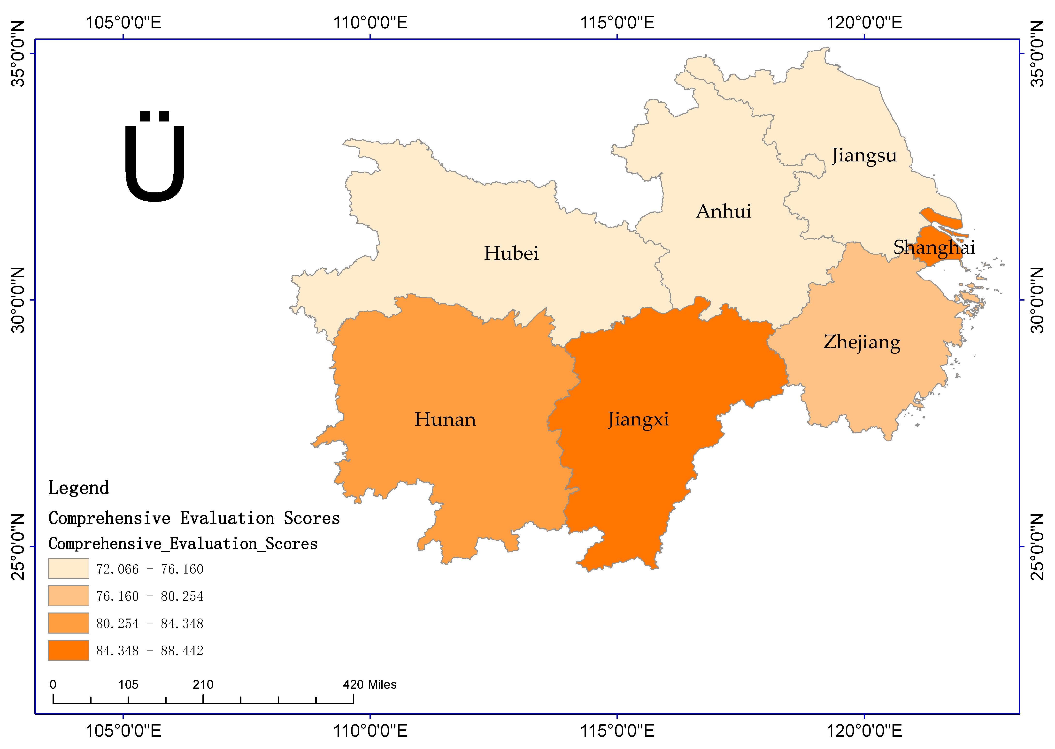
4.1. Comprehensive Evaluation of Land Ecological Safety

Figure 1 presents the comprehensive evaluation of land ecological security scores for each province and city in the middle and lower reaches of the Yangtze River. As shown in Figure 1, the comprehensive evaluation value of land ecological security in Shanghai was the highest in the middle and lower reaches of the Yangtze River, and its evaluation value was 88.442. The main reasons are twofold. First, although Shanghai has a very high population density as well as urbanization level, which is much higher than that in other provinces in the region, it has a much higher population and environmental carrying capacity than other provinces in the area due to its role as the financial and trade centre of China, where most of the energy, food and other resources converge. Second, the overall layout and planning of land in Shanghai is better, and its high degree of land intensification has led to a much higher economic density than that of other provinces in the region.
The comprehensive evaluation value of land ecological safety in Jiangxi ranked second, and its comprehensive evaluation value was 87.936. Possible causes are as follows. First, the urbanization level and pesticide and fertilizer use in Jiangxi Province is much lower than those in other provinces and cities in the region, and its economic and social development pressure, agricultural production, and living pressure have relatively less impact on the ecological safety of the land. Second, as a significant agricultural and forestry province, Jiangxi Province has the highest forest coverage rate in the region and far exceeds that of Anhui, Zhejiang, and Shanghai; additionally, its grain yield per acre and water resources per unit of arable land rank high for the region. Third, Jiangxi Province has continued to increase investment in ecological restoration and management in recent years, focusing on improving the harmless treatment of household waste and industrial waste treatment capacity, thus optimizing the ecological condition of the land in the region.
The comprehensive evaluation value of land ecological security in Hunan Province was at the top level in the middle and lower reaches of the Yangtze River, and its evaluation value was 81.481. According to the statistical data measurement, the reason for the high comprehensive evaluation value of Hunan Province is manifested in two aspects. First, the region’s population density and urbanization level are low, and energy waste emissions are low, so the pressure on land ecological security is relatively low. Second, the region’s forest cover and grain yield are relatively high, and land ecological security is better. The remaining four provinces, Zhejiang (76.614), Jiangsu (73.325), Hubei (72.069), and Anhui (72.068), had relatively low evaluation scores, and their land ecological security status was classified as poor.
Overall, the average value of the comprehensive land ecological evaluation score of the provinces and municipalities in the middle and lower reaches of the Yangtze River was 78.848. In contrast, the evaluation scores of Jiangxi, Hunan and Shanghai were higher than the average level in the middle and lower reaches of the Yangtze River, indicating that the provinces and municipalities’ land ecological security status was superior.

4.2. Evaluation of Land Ecological Safety Subsystem

4.2.1. Pressure Subsystem Analysis

Figure 2 presents the evaluation scores of the land ecological security pressure subsystem for each province and city in the middle and lower reaches of the Yangtze River. As shown in Figure 2, Shanghai’s pressure subsystem evaluation value score was at the top of those among the middle and lower reaches of the Yangtze River, and its value was 97.130. Hunan ranked second, with an evaluation score of 77.340. This result indicates that the two provinces are burdened by population pressure, energy use pressure, and ecological and environmental pressure, and the ecological security of the land is affected as a result. Among them, Shanghai’s pressure subsystem evaluation score is much higher than that of other regional provinces, mainly because Shanghai, as an industrial city, has greater industrial coercion on agricultural land. Hunan’s higher pressure subsystem score is because the province is a tourist city with a large migrant population, which further exacerbates the discharge of domestic waste. In contrast, the remaining five provinces, including Jiangxi (76.215), Jiangsu (70.232), Zhejiang (66.848), and Anhui (58.878), Hubei (57.130), experience less stress.

4.2.2. State Subsystem Analysis

Figure 3 presents the subsystem evaluation scores of the land ecological security status for each province and city in the middle and lower reaches of the Yangtze River. As shown in Figure 3, the ranking of the evaluation score of the subsystem of land ecological security status of each province and city in the region was as follows: Shanghai (93.622), Zhejiang (93.309), Anhui (84.89), Jiangsu (74.721), Jiangxi (66.122), Hunan (61.058), and Hubei (53.622). Among them, Shanghai had the highest ecological security status among the sites in the middle and lower reaches of the Yangtze River, and it was superior in terms of forest coverage, economic density, and water resources per unit of arable land area. As China’s financial center, Shanghai has muscular economic strength and a high level of population concentration, which, on the one hand, helps to promote regional economic growth, highlighted by higher per capita output rate, per capita output rate, and per capita consumption level; on the other hand, it can enhance the region’s potential for economic development, such as the advantages of resources, human talents, and market advantages. Thus, Shanghai can realize the integrated allocation of land resources to meet the needs of economic and social development. Zhejiang is second only to Shanghai regarding land ecological security and is superior in forest coverage and water resources per unit of arable land. Zhejiang is a significant forestry province in China, with 74.6% of its land area in the mountains, rich in forest resources, thus helping to stabilize soil and water and safeguard land ecological security. Anhui’s land ecological security is in third place in the basin, superior in energy self-sufficiency and the proportion of the arable land area. Jiangxi’s land ecological security is relatively good regarding forest coverage, forest cover, grain yield per mu, and water resources per unit of arable land. The ecological security of land in Hunan and Hubei was relatively poor. It should be optimized and improved to ensure an adequate energy supply, protect forests, continuously increase afforestation areas, and improve the efficiency of arable land use.

4.2.3. Response Subsystem Analysis

Figure 4 presents the evaluation scores of the land ecological security response subsystem for each province and city in the middle and lower reaches of the Yangtze River. According to Figure 4, the ranking of the evaluation scores of the land ecological security response subsystem of each province and city in the region was as follows: Jiangxi (90.897), Hunan (74.724), Hubei (69.332), Shanghai (60.542), Zhejiang (53.108), Anhui (51.534), and Jiangsu (50.897). According to the previous analysis, the responsiveness of land ecological security depends on the capacity of the harmless treatment of domestic waste, the ability to comprehensively utilize industrial waste, the area of afforestation and the amount of investment in ecological management. As shown by the response subsystem evaluation value scores, the degree of response to land ecological security issues in Jiangxi was superior in the region, followed by that of Hunan and Hubei. Anhui, Jiangsu, and Zhejiang, on the other hand, were relatively less responsive to land ecological security issues and need to increase the area of afforestation, the capacity of household waste harmless treatment and industrial waste treatment, and the amount of ecological restoration treatment, etc., through which the land ecological security status of the region is maintained.

4.3. Evaluation of System Coordination Degree

The PSR model system coordination degree indicates the degree of interconnection between the pressure, state, and response systems, and the higher the coefficient value is, the higher the coordination degree in a region. This response indicates that the spacing and dispersion of the region’s three pressure, state, and response subsystems are superior in the land ecological security issue. In this study, the determination of the land ecological security status of a region is not only based on the current land ecological security status of the area but also considers the future land ecological security status of the region, i.e., whether or not there is a land ecological security risk problem. Therefore, the fact that the coefficient of comprehensive land ecological security value and the coefficient of coordination are among the highest in the whole region indicates that the land ecological security status of the area is good and there is no potential risk of land environmental security. Figure 5 and Figure 6 present the coordination coefficient values and comprehensive evaluation scores of the land ecological security evaluation system for each province and city in the middle and lower reaches of the Yangtze River. Shanghai’s and Hunan’s comprehensive evaluation value and coordination coefficient are both ranked in the top three in the middle and lower reaches of the Yangtze River, and their comprehensive evaluation value is positively correlated with the coordination value of the subsystems; this result indicates that the land ecological security in the region is in a better condition. Zhejiang and other provinces have a negative correlation between the comprehensive evaluation value and the coordination coefficient, which may exist in the following situations. First, the high value of the coordination coefficient and the low value of the comprehensive evaluation indicate that the spacing and dispersion of the three subsystems of land ecological security pressure, state, and response in the region are superior, which can guarantee the synergistic development of land ecological security and land social security in the area; however, the form of its land ecological security is not optimistic, such as in Anhui and Jiangsu. Second, the low value of the coordination coefficient and the high value of the comprehensive evaluation indicate that the land ecological security status of the region is better. However, the spacing and dispersion of its three subsystems of land ecological security pressure, state, and response are in a disadvantageous position, i.e., the land ecological environment of the region is better. However, the land’s sustainable supply and self-security capacity have yet to be effectively utilized, and thus, there are potential land ecological security risk problems, such as in Jiangxi Province. The above shows that the middle and lower reaches of the Yangtze River, except Shanghai, have certain land ecological security risks, and thus, it is necessary to do an excellent job in the overall planning and layout of the land, increase ecological restoration and management efforts, constantly improve the comprehensive utilization rate of exhaust gas and the rate of harmless garbage treatment, and strive to optimize the ecological security of the land in this region.

5. Discussion

In this paper, systematic thinking is applied to incorporate land ecological security and land social security into the same land ecological security analysis framework, and the PSR model and ArcGIS mapping software are used to analyze and measure the land ecological security in the middle and lower reaches of the Yangtze River in China. Regional land ecological security is closely related to the economic development of the region, i.e., how to harmonize the relationship between land use and economic development, which is consistent with the findings of Wang [43], Huang [44], and Zhang [45]. Compared with previous studies, this study includes the indicators of regional food yield capacity per mu and regional energy self-sufficiency rate, which respond to the supply capacity of land resources and self-security of land social security, into the framework system of land ecological security analysis, which is more responsive to the sustainable utilization of land [46]. On the one hand, a lower level of regional economic development, even if the land ecological environment in the region is better, may lead to land ecological security problems because the land’s sustainable supply capacity or self-security capacity has not been effectively utilized. On the other hand, due to the rapid pace of regional economic development, some regions have fully utilized the supply and security capacity of the land. However, due to the need for more scientific and reasonable land use development planning, there is a possibility of triggering a series of land ecological security problems.
This study used the PSR model to measure land ecological security. By incorporating the region’s current land ecological security status and potential risk problems into a unified system, on the one hand, it can reflect the current land ecological security status of a region more intuitively; on the other hand, it can also be observed whether there is a risk problem of land ecological security in the future of the region, which is in line with the results of the studies conducted by GUO [47], Yang [29]. Second, this study used the mean and standard deviation of the indicators to construct the indicator coefficient of variation and adjusted the weights concerning the opinions of experts and scholars to arrive at the final weights of the indicators. This realizes the combination of subjectivity and objectivity in determining the weights and avoids the problems of the entropy assignment method, which cannot determine the weights step by step and has a significant difference in the individual weights [48], and the hierarchical analysis method, which is more subjective [49], and makes the results of the weighting evaluation more reliable.
Therefore, the following aspects can be analyzed to harmonize the relationship between economic development and sustainable land use and to safeguard regional land ecological security. First, it is necessary to formulate a reasonable land ecological mitigation plan through the radiation of large towns to drive the development of the surrounding areas, thus recruiting employment from the surrounding areas to alleviate the population pressure of large cities and optimize the demographic layout. At the same time, it is necessary to strengthen ecological and environmental protection education and enhance residents’ awareness of environmental protection. Second, the arable land protection system is being strictly implemented, and the construction of high-standard farmland is being carried out to improve land use efficiency through intensive and large-scale land management to ensure the strict fulfilment of the policy of red lines for arable land. Third, the implementation of the following policy measures is recommended: closing the mountains and planting forests, protecting existing forestland, increasing the area of afforestation, and restoring grass and forest vegetation of barren mountains and wasteland.
Additionally, while guaranteeing the actual benefits to which farmers are entitled, these policies encourage them to return their farmland to forests to develop the forest economy and optimize the ecological security of the existing land. Fourth, Shanghai and other highly urbanized areas with a relatively low share of agriculture and a high economic level need to give full play to their existing economic advantages and continue to increase scientific and technological investments in developing a circular economy. Moreover, it is necessary to strengthen the ecological monitoring of the land and to severely penalize indiscriminate discharges and emissions of industrial and energy wastes to minimize the impact of economic and social development on ecological degradation. Fifth, urban and rural land should be utilized in an integrated manner; on the one hand, urban areas should realize the intensive use of land, develop land rationally and orderly, and give full play to the land’s potential to enhance the land’s output efficiency. On the other hand, strict land-use control should be implemented in rural areas to take advantage of existing resource endowments and carry out a variety of forms of eco-agricultural innovations to promote sustainable land development.
Admittedly, this paper has certain shortcomings. First, the research area needs to be expanded. This paper analyzes only the land ecological security of a particular river basin in China, and whether its conclusions align with the characteristics of other regions still needs to be further screened. However, the research idea of the article can be used as a reference. Second, the research data needs to be further updated. The data in this paper came from the National Statistical Yearbook of China. However, due to China’s relatively vast land area and large population, data collection and processing are extremely difficult. Hence, the timeliness of the data is relatively weak, which also provides ideas for subsequent research. Therefore, the scope of the study area can be expanded, and by comparing the ecological security of land in different regions, development strategies suitable for the sustainable utilization of land in different types of regions can be derived [50]. In addition, it is also necessary to pay attention to the dynamic development of regional land and strengthen the dynamic monitoring of the ecological security of regional land [51,52].

6. Conclusions

The ecological safety status of land is related to the sustainability of human society. This paper evaluated the land ecological security of six provinces in the middle and lower reaches of the Yangtze River using the PSR model, and the objective was to analyze the influencing factors of land ecological security. The study concluded with the following points.
(1)
The stronger a region’s economy is, the better its land security. Shanghai is an international financial and trade centre where the most resources converge, and the province has a better overall land layout, better planning, and a higher degree of intensive land use, thus showing a very high level of land carrying capacity, making the province’s land ecological security situation superior.
(2)
The richer an area’s factor resources are, the better the land security status. As a major agricultural and forestry province in China, Jiangxi is rich in forest resources and has a strong food supply capacity. The province’s water resources possession per unit of arable land area and energy self-sufficiency rate are among the highest in the region, thus making the province’s land ecological security status superior.
(3)
The synergistic relationship between regional economic development and land use is essential for judging whether an area has a potential land ecological security crisis. Although Jiangxi’s land ecological security situation is relatively good because its land resources have yet to be effectively utilized, the region can potentially develop a particular land ecological security crisis.

Author Contributions

Conceptualization, B.L.; methodology, S.Y. and L.Y.; formal analysis, S.Y. and L.Y.; investigation, S.Y.; data curation, W.L. and Y.Y.; writing—original draft preparation, S.Y.; writing—review and editing, B.L. and Z.S.; supervision, Z.S.; All authors have read and agreed to the published version of the manuscript.

Funding

This research received no external funding.

Institutional Review Board Statement

Not applicable.

Informed Consent Statement

Not applicable.

Data Availability Statement

The data used in this paper are published open-source data available at http://www.stats.gov.cn/sj/zgtjnj/ (accessed on 15 September 2021).

Conflicts of Interest

The authors declare no conflict of interest.

References

  1. Liu, Q.; Chen, L.; Shu, B.; Hu, Y. Dynamic security assessment of land ecology in Changsha-Zhuzhou-Xiangtan urban agglomeration. Resour. Environ. Yangtze Basin 2010, 10, 1192–1197. [Google Scholar]
  2. Hou, H. Changes of agricultural land quantity and ecological security assessment in Shandong province. Chin. J. Agric. Resour. Reg. Plan. 2018, 2, 183–188. [Google Scholar]
  3. Yu, X.; Lv, C.; Guo, X.; Zhang, Z.; Li, S.; Hao, J. Assessment on the Status of land ecosystem in Beijing-Tianjin-Hebei region. China Land Sci. 2018, 4, 89–96. [Google Scholar]
  4. Li, J.; Yuan, W. Assessment of urban land ecological security in Yinchuan city based on the Grid method. J. Nat. Resour. 2017, 6, 988–1001. [Google Scholar]
  5. Li, H.; Li, S.; Yin, M. Research progress and prospect of land ecological security in China. J. Arid Land Resour. Environ. 2016, 9, 50–56. [Google Scholar]
  6. Huang, H.; Luo, W.; Wu, C.; Li, D. Evaluation of land eco-security based on matter element analysis. Trans. Chin. Soc. Agric. Eng. 2010, 3, 316–322. [Google Scholar]
  7. Huang, L.; Yang, P. Identification and Optimization of Land Ecological Security Pattern in Wuhan Metropolitan Area Based on Machine Learning. J. Ecol. Rural Environ. 2020, 7, 862–869. [Google Scholar]
  8. Ma, S.; Xie, D.; Zhang, X.; Peng, Z.; Hong, H.; Luo, Z.; Xiao, J. Measures of land ecological security early warning and its spatial-temporal evolution in the ecologically sensitive area of the Three Gorges reservoir area: A case study of Wanzhou District, Chongqing City. Acta Ecol. Sin. 2017, 24, 8227–8240. [Google Scholar]
  9. Zhang, L.; Chen, Y.; Wang, S.; Men, M.; Xu, H. Assessment and early warning of land ecological security in rapidly urbanizing coastal Area: A case study of Caofeidian New District, Hebei, China. Chin. J. Appl. Ecol. 2015, 08, 2445–2454. [Google Scholar]
  10. Chen, D.Q.; Lan, Z.Y.; Li, W.Q. Construction of land ecological security in Guangdong Province from the perspective of ecological demand. J. Ecol. Rural Environ. 2019, 35, 826–835. [Google Scholar]
  11. Chen, L.; Zhao, H.; Song, G.; Liu, Y. Optimization of cultivated land pattern for achieving cultivated land system security: A case study in Heilongjiang Province, China. Land Use Policy 2021, 108, 105589. [Google Scholar] [CrossRef]
  12. Li, Y.; Lian, Z.; Zhai, T.; Xie, X.; Wang, Y.; Li, M. Assessment of Land Ecological Security Based on the Boston Model: A Case Study from China. Land 2023, 12, 1348. [Google Scholar] [CrossRef]
  13. Ghosh, S.; Chatterjee, N.D.; Dinda, S. Urban ecological security assessment and forecasting using integrated DEMATEL-ANP and CA-Markov models: A case study on Kolkata Metropolitan Area, India. Sustain. Cities Soc. 2021, 68, 102773. [Google Scholar] [CrossRef]
  14. Su, S.; Chen, X.; DeGloria, S.D.; Wu, J. Integrative fuzzy set pair model for land ecological security assessment: A case study of Xiaolangdi Reservoir Region, China. Stoch. Environ. Res. Risk Assess. 2010, 24, 639–647. [Google Scholar] [CrossRef]
  15. Cheng, H.; Zhu, L.; Meng, J. Fuzzy evaluation of the ecological security of land resources in mainland China based on the Pressure-State-Response framework. Sci. Total Environ. 2022, 804, 150053. [Google Scholar] [CrossRef]
  16. Zhang, R.; Pu, L.; Li, J.; Zhang, J.; Xu, Y. Landscape ecological security response to land use change in the tidal flat reclamation zone, China. Environ. Monit. Assess. 2016, 188, 1. [Google Scholar] [CrossRef]
  17. Wei, S.; Pan, J.; Liu, X. Landscape ecological safety assessment and landscape pattern optimization in arid inland river basin: Take Ganzhou District as an example. Hum. Ecol. Risk Assess. Int. J. 2020, 26, 782–806. [Google Scholar] [CrossRef]
  18. Zhang, F.T.; Wang, L.C.; Su, W.C. Evaluation of land ecological security in Chongqing based on the matter-element analysis-DPSIR model. China Environ. Sci. 2016, 36, 3126–3134. [Google Scholar]
  19. Zhang, H.; Yan, Q.; Xie, F.; Ma, S. Evaluation and Prediction of Landscape Ecological Security Based on a CA-Markov Model in Overlapped Area of Crop and Coal Production. Land 2023, 12, 207. [Google Scholar] [CrossRef]
  20. Wang, N.; Li, S.; Kang, Q.; Wang, Y. Exploring the land ecological security and its spatio-temporal changes in the Yangtze River Economic Belt of China 2000–2020. Ecol. Indic. 2023, 154, 110645. [Google Scholar] [CrossRef]
  21. Huang, Q.; Peng, B.; Elahi, E.; Wan, A. Evolution and driving mechanism of ecological security pattern: A case study of Yangtze River urban agglomeration. Integr. Environ. Assess. Manag. 2021, 17, 573–583. [Google Scholar] [CrossRef] [PubMed]
  22. Xie, H.; He, Y.; Choi, Y.; Chen, Q.; Cheng, H. Warning of negative effects of land-use changes on ecological security based on GIS. Sci. Total Environ. 2020, 704, 135427. [Google Scholar] [CrossRef]
  23. Wu, L.; Zhou, J.; Li, Z. Applying of GA-BP neural network in the land ecological security evaluation. IAENG Int. J. Comput. Sci. 2020, 47, 11–18. [Google Scholar]
  24. Chen, T.; Peng, L.; Wang, Q. Response and multiscenario simulation of trade-offs/synergies among ecosystem services to the Grain to Green Program: A case study of the Chengdu-Chongqing urban agglomeration, China. Environ. Sci. Pollut. Res. 2022, 29, 33572–33586. [Google Scholar] [CrossRef] [PubMed]
  25. Zhou, Y.-X.; Li, Y.-X.; Sun, Y.-Y.; Li, J.-T.; Gao, G.-F.; Su, C. Evaluation of land ecological security in Shandong Province based on PSR-TOPSIS model. J. Agric. Resour. Environ. 2016, 33, 320. [Google Scholar]
  26. Zhu, X.; Li, Z. Optimization of spatial pattern of rural ecological security in metropolis based on PSR model: A case study of Wuhan. Mod. Urban Res. 2021, 10, 118–124. [Google Scholar]
  27. Zeng, Y.; Fu, H.; Shui, Y. Research on flood risk of cultural heritage in Chengdu city based on a PSR-SPA model. Bull. Soil Water Conserv. 2021, 5, 296–303. [Google Scholar]
  28. Cao, W.; Liu, X.; Zhao, T.; Tian, L.; Liu, Y. Evaluation of water environmental health of PAN’ AN lake wetland based on pressure-state-response (PSR) model. Environ. Eng. 2021, 5, 231–237+245. [Google Scholar]
  29. Yang, J.; Song, Z.; Li, Z. Assessment of cultivated land ecological safety based on PSR method the case study of main grain production area of the lower Yangtze region. Res. Soil Water Conserv. 2017, 3, 301–307+313. [Google Scholar]
  30. Liu, B.; Yu, S.; Song, Z.; Yang, L. Research on regional energy security from the perspective of energy supply and demand balance: Take 30 provinces in China as an example. J. China Univ. Pet. (Ed. Soc. Sci.) 2023, 39, 1–8. [Google Scholar]
  31. Zeng, P.; Wang, J. Spatiotemporal characteristics of land pressure-bearing and pressure-applying coupling curves of China’s urban agglomerations. Stat. Decis. 2021, 2, 56–59+63. [Google Scholar]
  32. Liu, W. On the methodology of land population-supporting capacity study. Areal Res. Dev. 1992, 1, 26–28+63. [Google Scholar]
  33. Du, G.; Xie, J.; Hou, D.; Yu, F. Regional differences in the green use level of cultivated land in the Heilongjiang reclamation area. Front. Environ. Sci. 2023, 11, 411. [Google Scholar] [CrossRef]
  34. Chen, J.; Zhou, C.; Wang, S.; Li, S. Impacts of energy consumption structure, energy intensity, economic growth, urbanization on PM2. 5 concentrations in countries globally. Appl. Energy 2018, 230, 94–105. [Google Scholar] [CrossRef]
  35. Liang, L.; Yang, N.; Ou, Z.; Wang, S.; Shi, Y.; Chen, X.; Sun, Y. Multi-scale spatial pattern of urban land economic density and its influencing factors in the Yellow River basin. Sci. Geogr. Sin. 2021, 8, 1336–1344. [Google Scholar]
  36. Liu, S.; Cai, Y.; Wang, Z. China’s Potential Economic Growth fromthe Perspective of Population Density. Econ. Rev. J. 2023, 1, 41–60. [Google Scholar]
  37. Cao, L.; Zhou, T.; Luo, H.; Li, Z.; Xu, P.; Liu, X. The mediation of forest coverage in the responses of forest to climate drought. J. Beijing Norm. Univ. (Nat. Sci.) 2019, 2, 240–247. [Google Scholar]
  38. Zhao, H.-B.; Ma, Y.-J. Spatial-temporal pattern and obstacle factors of cultivated land ecological security in major grain producing areas of northeast China: A case study in Jilin Province. Chin. J. Appl. Ecol. 2014, 2, 515–524. [Google Scholar]
  39. Wang, J.; Huang, X.; Zheng, Z.; Shao, X. Improving the quality of cultivated land is more important for food security. China Land Sci. 2011, 5, 35–38. [Google Scholar]
  40. Xue, F.; Kong, R.; Zhong, W. Energy self-supply rate and carbon dioxide emission in Qinghai province. Resour. Ind. 2016, 3, 73–79. [Google Scholar]
  41. Xu, H.; Lei, G.; Cui, D.; Zhao, H. Study on evaluation for ecological security of cultivated land—A case study of Ning’an city in Heilongjiang province. Res. Soil Water Conserv. 2021, 6, 180–184+189. [Google Scholar]
  42. Li, Z.; Zhu, Q.; Hua, M.; Zhou, M. Evaluation of ecological civilization construction based on the PSR model in Jiangxi. Guizhou Agric. Sci. 2014, 12, 180–184+189. [Google Scholar]
  43. Wang, W.; LI, M. Spatiotemporal change of land ecological security in Hunan based on DPSIR. Chin. J. Ecol. 2020, 39, 2724–2736. [Google Scholar]
  44. Huang, L.; Yang, P. Spatio-temporal Evolution Characteristics and Influencing Factors of Land Ecological Security in the Yangtze River Economic Belt. Resour. Environ. Yangtze Basin 2019, 28, 1780–1790. [Google Scholar]
  45. Zhang, D.; Wang, X.; Qu, L.; Li, S.; Lin, Y.; Yao, R.; Zhou, X.; Li, J. Land use/cover predictions incorporating ecological security for the Yangtze River Delta region, China. Ecol. Indic. 2020, 119, 106841. [Google Scholar] [CrossRef]
  46. Duan, Z. Some reflections on the concept of land in land science. China Land Sci. 2000, 4, 18–21. [Google Scholar]
  47. Guo, D.; Wang, D.; Zhong, X.; Yang, Y.; Jiang, L. Spatiotemporal changes of land ecological security and its obstacle indicators diagnosis in the Beijing–Tianjin–Hebei Region. Land 2021, 10, 706. [Google Scholar] [CrossRef]
  48. Yang, C.; He, K.; Li, C. Dynamic evaluation of land ecological security in Hunan Province. Land Resour. Her. 2008, 5, 41–43. [Google Scholar]
  49. Wang, P.; Tang, L.; Tian, Y.; Deng, Y.; Kuang, F. Evaluation on ecological security of land resource in Hunan Province. Resour. Dev. Mark. 2012, 28, 257–261. [Google Scholar]
  50. Wang, L.; Chang, J.; He, B.; Guo, A.; Wang, Y. Analysis of oasis land ecological security and influencing factors in arid areas. Land Degrad. Dev. 2023, 34, 3550–3567. [Google Scholar] [CrossRef]
  51. Liu, J.; Cao, X.; Zhao, L.; Dong, G.; Jia, K. Spatiotemporal differentiation of land ecological security and its influencing factors: A case study in Jinan, Shandong Province, China. Front. Environ. Sci. 2022, 10, 8. [Google Scholar] [CrossRef]
  52. Wen, M.; Zhang, T.; Li, L.; Chen, L.; Hu, S.; Wang, J.; Liu, W.; Zhang, Y.; Yuan, L. Assessment of land ecological security and analysis of influencing factors in Chaohu Lake Basin, China from 1998–2018. Sustainability 2021, 13, 358. [Google Scholar] [CrossRef]
Figure 1. Comprehensive Evaluation Scores.
Sustainability 15 14098 g001
Figure 2. Evaluation Value of the Pressure Subsystem.
Sustainability 15 14098 g002
Figure 3. Evaluation Scores of the State Subsystem.
Sustainability 15 14098 g003
Figure 4. Response subsystem evaluation scores.
Sustainability 15 14098 g004
Figure 5. Coordination Coefficient.
Sustainability 15 14098 g005
Figure 6. Comprehensive Evaluation Score.
Sustainability 15 14098 g006
Table 1. Comprehensive evaluation index system of land ecological security in the middle and lower reaches of the Yangtze River.
Target LayerIndicatorsSecondary IndicatorsIndicator DirectionIndicator Weights
Composite system of land ecological security, energy security and food security in the Yangtze River BasinPressureNatural population growth rateNegative0.055
Urbanization rateNegative0.037
Wastewater discharge per unit of industrial outputNegative0.026
Energy waste emissions per unit areaNegative0.088
Pesticide use per unit of arable land areaNegative0.047
Fertilizer application per unit of arable land areaNegative0.047
Energy consumption intensityNegative0.064
Replanting indexNegative0.076
StatusEconomic densityPositive0.075
Population densityPositive0.058
Forest coverPositive0.062
Share of arable landPositive0.048
Grain yield per acrePositive0.080
Water possession per unit of arable land areaPositive0.080
Energy self-sufficiency ratePositive0.084
ResponseChange rate of harmless treatment of domestic wastePositive0.092
The rate of change in the comprehensive utilization of industrial wastePositive0.108
Rate of change of afforestation area as a proportion of total land areaPositive0.071
Rate of change of investment in ecological management as a share of GDPPositive0.125
Disclaimer/Publisher’s Note: The statements, opinions and data contained in all publications are solely those of the individual author(s) and contributor(s) and not of MDPI and/or the editor(s). MDPI and/or the editor(s) disclaim responsibility for any injury to people or property resulting from any ideas, methods, instructions or products referred to in the content.

