
Evaluation of Living Environment Quality in Urban Residential Areas under the Concept of Urban Renewal—A Case Study of Binjiang District, Hangzhou, China


Abstract
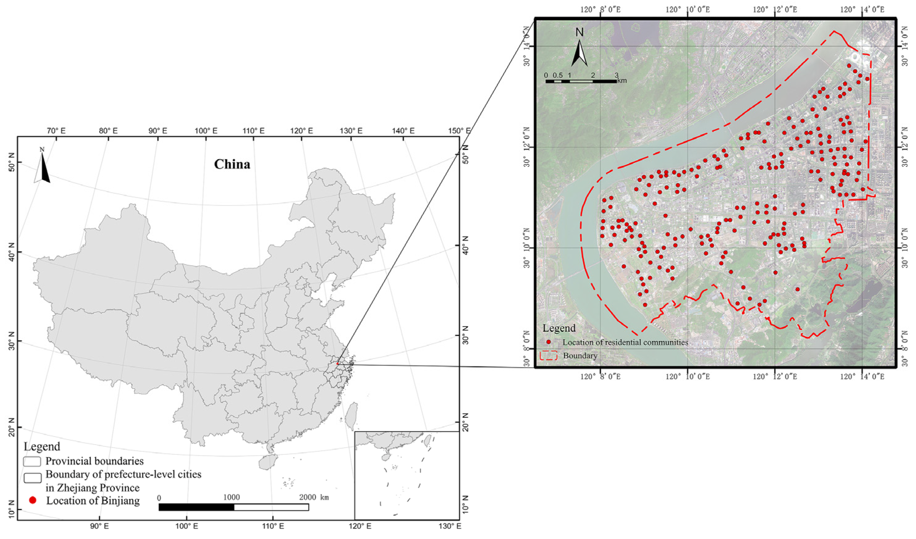
:1. Introduction
2. Materials and Methods
2.1. Indicator Selection
2.2. Measurement of Indicators
2.3. Determination of Weights
2.4. Hotspot Analysis
3. Results
3.1. Overall Evaluation
3.2. Dimensional Evaluation
3.3. Spatial Pattern of Hotspots
4. Discussion
5. Conclusions and Suggestions
5.1. Conclusions
- (1)
- The quality of the living environment in Binjiang District exhibits distinct spatial variations. Consistent with previous research findings, areas with higher living environment quality are primarily concentrated around the university campus and the district government center and gradually decrease to the suburbs. Future urban renewal planning needs to comprehensively consider both the revitalization of central areas and the balanced development of peripheral regions to promote sustainable progress in the economy, society, and environment.
- (2)
- In terms of specific criteria for the living environment, there is an overall pattern of higher residential and environmental quality along the riverside areas, lower quality in the inner regions, higher quality in the new districts, and lower quality in the old districts. The quality of transportation and communication shows a trend of multiple core points radiating outward with decreasing quality. Other criteria indicate that high-quality residential areas are mainly concentrated in the district government zone and the vicinity of Binjiang University City. Future urban renewal will focus on improving spatial efficiency and social equity.
- (3)
- Hotspot analysis reveals a positive correlation between the quality of the living environment and the degree of aggregation. Communities with high living environment quality have higher agglomeration degrees than those with low living environment quality. Future urban renewal planning should not only concentrate on enhancing the quality of life in highly clustered areas but also adopt a decentralized development strategy to create a livable environment in the surrounding areas, achieving a rational distribution of population and resources.
5.2. Suggestions
Author Contributions
Funding
Institutional Review Board Statement
Informed Consent Statement
Data Availability Statement
Conflicts of Interest
References
- Chen, C.Y.; Zhang, W.Z.; Zhan, D.S.; Li, X.L. Quantitative evaluation of human settlement environment and influencing factors in the Bohai Rim area. Prog. Geogr. 2017, 36, 1562–1570. [Google Scholar]
- Reeves, D. Putting women and gender in the frame–A consideration of gender in the Global Report on Human Settlement Planning Sustainable Cities 2009. Habitat. Int. 2014, 43, 293–298. [Google Scholar] [CrossRef]
- Charoenkit, S.; Kumar, S. Environmental sustainability assessment tools for low carbon and climate resilient low income housing settlements. Renew. Sust. Energ. Rev. 2014, 38, 509–525. [Google Scholar] [CrossRef]
- Adewunmi, Y.; Chigbu, U.E.; Mwando, S.; Kahireke, U. Entrepreneurship role in the co-production of public services in informal settlements− A scoping review. Land Use Pol. 2023, 125, 106479. [Google Scholar] [CrossRef]
- McNeill, L.H.; Kreuter, M.W.; Subramanian, S.V. Social environment and physical activity: A review of concepts and evidence. Soc. Sci. Med. 2006, 63, 1011–1022. [Google Scholar] [CrossRef]
- Schetke, S.; Haase, D.; Kötter, T. Towards sustainable settlement growth: A new multi-criteria assessment for implementing environmental targets into strategic urban planning. Environ. Impact Assess. Rev. 2012, 32, 195–210. [Google Scholar] [CrossRef]
- Sebti, M.; Alkama, D.; Bouchair, A. Assessment of the effect of modern transformation on the traditional settlement ‘Ksar’of Ouargla in southern Algeria. Front. Archit. Res. 2013, 2, 322–337. [Google Scholar] [CrossRef]
- Kim, H.W.; Aaron McCarty, D.; Lee, J. Enhancing Sustainable Urban Regeneration through Smart Technologies: An Assessment of Local Urban Regeneration Strategic Plans in Korea. Sustainability 2020, 12, 6868. [Google Scholar] [CrossRef]
- Wang, J.; Yang, Y.; Huang, H.; Wang, F. Stakeholder Management in Government-Led Urban Regeneration: A Case Study of the Eastern Suburbs in Chengdu, China. Sustainability 2022, 14, 4357. [Google Scholar] [CrossRef]
- Pollard, J.S. From Industrial District to “Urban Village”? Manufacturing, Money and Consumption in Birmingham’s Jewellery Quarter. Urban Stud. 2004, 41, 173–193. [Google Scholar] [CrossRef]
- Kipfer, S.; Keil, R. Toronto Inc? Planning the competitive city in the new Toronto. Antipode 2002, 34, 227–264. [Google Scholar] [CrossRef]
- Sacco, P.; Tavano Blessi, G. The Social Viability of Culture-led Urban Transformation Processes: Evidence from the Bicocca District, Milan. Urban Stud. 2009, 46, 1115–1135. [Google Scholar] [CrossRef]
- Zheng, H.W.; Shen, G.Q.; Wang, H. A review of recent studies on sustainable urban renewal. Habitat Int. 2014, 41, 272–279. [Google Scholar] [CrossRef]
- Olabisi, Y.S. Gender issue and urban renewal development: An examination of challenges of evicted market women in Lagos State, Nigeria. Am. J. Rural. Dev. 2013, 1, 19–25. [Google Scholar]
- Wang, Y.T.; Wang, X.R.; Dou, Z. Study on the application of the index system of urban human settlements quality evaluation: Based on the practice of pilot cities. J. Hum. Settl. West China 2021, 36, 50–56. [Google Scholar]
- Cui, F.Q.; Tang, H.P.; Zhang, Q. Evaluation of urban livability and analysis of influencing factors in Beijing-Tianjin-Hebei region: Empirical research based on panel data from 2010 to 2016. J. Beijing Norm. Univ. Nat. Sci. 2018, 54, 666–673. [Google Scholar]
- Gawai, N.; Phadke, A. Quality of urban life: Identification of livable urban spaces within Mumbai metropolitan region. Int. Arch. Photogramm. Remote Sens. Spat. Inf. Sci. 2018, XLII-5, 117–121. [Google Scholar] [CrossRef]
- Liu, S.; Liu, B.Y. Study on Evaluation Index System of Sustainable Development for Urban Human Settlement. Urban Plan. Rev. 1999, 5, 35–37. [Google Scholar]
- Bao, J.; Zhang, Y.; Li, X.; Guo, Q. From Survival to Self-Actualization: Quantitative evaluation of human settlement environment from the perspective of hierarchy of needs theory: A case study of An hui Province. Urban Stud. 2020, 27, 88–95. [Google Scholar]
- Zhang, Z.B.; Ju, J.L.; Chen, Z.J. Evaluation of urban livability and its spatial characteristics in Lanzhou. Acta Ecol. Sin. 2014, 34, 6379–6389. [Google Scholar]
- Fu, B.; Yu, D.; Zhang, Y. The livable urban landscape: GIS and remote sensing extracted land use assessment for urban livability in Changchun Proper, China. Land Use Pol. 2019, 87, 104048. [Google Scholar] [CrossRef]
- Long, Y.; Li, M.Y.; Li, J. Monitoring of Chinese human settlement environment quality based on new data: Indicator system and typical cases. Urban Dev. Res. 2018, 25, 86–96. [Google Scholar]
- Ta, N.; Zhao, Y.; Chai, Y.W. Built environment, peak hours and route choice efficiency: An investigation of commuting efficiency using GPS data. J. Transp. Geogr. 2016, 57, 161–170. [Google Scholar] [CrossRef]
- Xiong, W.Y. The Urban Settlement Research in the Perspective of Public Facilities: A Case Study of Nanjing. Mod. Urban Res. 2010, 25, 35–42. [Google Scholar]
- Shen, Y.; Chai, Y. Daily activity space of suburban mega-community residents in Beijing based on GPS data. Acta Geogr. Sin. 2013, 68, 506–516. [Google Scholar]
- Zhang, W.Z. The core framework of livable urban construction. Geography 2016, 35, 205–213. [Google Scholar]
- Zhang, Z.; Wei, Z.Q. Study and application of urban human settlements assessment system. Ecol. Environ. 2006, 15, 198–201. [Google Scholar]
- Xiao, L.Y. Study on indicator system of global livable cities and international comparison of Guangzhou. J. Urban Stud. 2019, 40, 58–63. [Google Scholar]
- Shen, S.; Ma, Y.; Hu, T.H. Research on evaluation of urban human settlements quality based on multi-source data. J. Hum. Settl. West China 2022, 37, 48–54. [Google Scholar]
- Chen, J. Temporal-spatial assessment of the vulnerability of human settlements in urban agglomerations in China. Environ. Sci. Pollut. Res. 2023, 30, 3726–3742. [Google Scholar] [CrossRef]
- Zhou, J.; Liu, L.; Li, H.; Pei, D. Evaluation and analysis on suitability of human settlement environment in Qingdao. PLoS ONE 2021, 16, e0256502. [Google Scholar]
- Guan, Y.; Li, X.; Yang, J.; Li, S.; Tian, S. Spatial differentiation of comprehensive suitability of urban human settlements based on GIS: A case study of Liaoning Province, China. Environ. Dev. Sustain. 2022, 24, 4150–4174. [Google Scholar] [CrossRef]
- Zhai, G.; Min, X. Perceptual image quality assessment: A survey. Sci. China-Inform. Sci. 2020, 63, 84–135. [Google Scholar] [CrossRef]
- Min, X.; Gu, K.; Zhai, G.; Yang, X.; Zhang, W.; Le Callet, P.; Chen, C.W. Screen content quality assessment: Overview, benchmark, and beyond. ACM Comput. Surv. 2021, 54, 1–36. [Google Scholar] [CrossRef]
- Min, X.; Zhai, G.; Zhou, J.; Zhang, X.P.; Yang, X.; Guan, X. A multimodal saliency model for videos with high audio-visual correspondence. IEEE Trans. Image Process. 2020, 29, 3805–3819. [Google Scholar] [CrossRef] [PubMed]
- Min, X.; Zhai, G.; Gu, K.; Yang, X. Fixation Prediction through Multimodal Analysis. ACM Trans. Multimed. Comput. Commun. Appl. 2016, 13, 1–23. [Google Scholar]
- Min, X.; Gu, K.; Zhai, G.; Liu, J.; Yang, X.; Chen, C.W. Blind quality assessment based on pseudo-reference image. IEEE Trans. Multimed. 2017, 20, 2049–2062. [Google Scholar] [CrossRef]
- Min, X.; Ma, K.; Gu, K.; Zhai, G.; Wang, Z.; Lin, W. Unified blind quality assessment of compressed natural, graphic, and screen content images. IEEE Trans. Image Process. 2017, 26, 5462–5474. [Google Scholar] [CrossRef]
- Min, X.; Zhou, J.; Zhai, G.; Le Callet, P.; Yang, X.; Guan, X. A Metric for light field reconstruction, compression, and display quality evaluation. IEEE Trans. Image Process. 2020, 29, 3790–3804. [Google Scholar] [CrossRef]
- Min, X.; Zhai, G.; Gu, K.; Zhu, Y.; Zhou, J.; Guo, G.; Yang, X.; Guan, X.; Zhang, W. Quality evaluation of image dehazing methods using synthetic hazy images. IEEE Trans. Multimed. 2019, 21, 2319–2333. [Google Scholar] [CrossRef]
- Min, X.; Zhai, G.; Gu, K.; Liu, Y.; Yang, X. Blind image quality estimation via distortion aggravation. IEEE Trans. Broadcast. 2018, 64, 508–517. [Google Scholar] [CrossRef]
- Min, X.; Zhai, G.; Zhou, J.; Farias, M.C.; Bovik, A.C. Study of subjective and objective quality assessment of audio-visual signals. IEEE Trans. Image Process. 2020, 29, 6054–6068. [Google Scholar] [CrossRef] [PubMed]
- Min, X.; Zhai, G.; Gu, K.; Yang, X.; Guan, X. Objective quality evaluation of dehazed images. IEEE Trans. Intell. Transp. Syst. 2018, 20, 2879–2892. [Google Scholar] [CrossRef]


| Typical Case | Indicator Coverage | Subject of Evaluation | Evaluation Methodology | Data Sources |
|---|---|---|---|---|
| One New York: The Plan for a Strong and Just City (2015), The London Plan: Spatial Development Strategy for Greater London (2015), Creating the Future: Tokyo Metropolitan Long-Term Vision (2020), Sydney City Strategic Plan: Sustainable Sydney 2030, et al. | The assessment criteria for the cases commonly encompass indicators such as economic development, environmental preservation, energy efficiency, residential conditions, sustainable transportation, employment, healthcare, elderly care, education, historical and cultural preservation, and community development. These indicators underscore the challenges and opportunities that cities face within specific time frames. For instance, New York City places a prominent focus on the key principle of “equity and fairness.” Tokyo, leveraging the occasion of the 2020 Olympic Games, aims to mitigate issues like stagnant economic growth, population decline, and regional development imbalances. London emphasizes the concept of comprehensive planning, accentuating the quality and excellence of urban development. Meanwhile, Sydney highlights the pursuit of sustainable urban growth and enhanced livability. | The assessment focuses on the execution of urban planning initiatives and the advancement of planning policies. | Indicators encompass both qualitative and quantitative types. The evaluation methods employed comprise assigning scores or computing indices. | The data are primarily sourced from government data. |
| ISO 37120 Urban Sustainable Development Indicator System, International Green Model New Town Standard 3.0, United Nations Sustainable Development Goals Index, and others. | The case evaluation indicators cover major areas including resource and environment, economic development, and social equity. | The evaluation targets include urban service level, quality of life, and degree of sustainable development. | Indicators encompass both qualitative and quantitative types. The evaluation methods employed comprise assigning scores or computing indices. | The data are primarily reported by the cities themselves. |
| Asian Green City Index, European Green Capital Evaluation Indicator System. | The case indicators are primarily focused on “green” aspects such as energy supply, resource utilization, and ecological environment. | The evaluation targets include urban service level, quality of life, and degree of sustainable development. | Indicators encompass both qualitative and quantitative types. The evaluation methods employed comprise assigning scores or computing indices. | International organizations obtain evaluation data from publicly available official databases or collect them through various channels from government officials and relevant individuals. |
| Green Development Indicator System. | The case evaluation indicators include municipal facilities, transportation, ecological environment, economic development, resource conservation, rural living conditions, and other indicators. | The evaluation targets the quality of urban living environment. | The indicator type is quantitative indicators. The green development score of cities is calculated using a composite index method. | The data are submitted by various regions and departments. |
| Evaluation Indicator System for China Habitat Environment Award, Scientific Evaluation Criteria for Livable Cities. | The case evaluation indicators include municipal facilities, transportation, ecological environment, economic development, resource conservation, social security, community development, public services, public safety, housing conditions, public participation, and indicators related to historical and cultural heritage as well as urban characteristics. | The evaluation targets the quality of urban living environment. | Indicators encompass both qualitative and quantitative types. The evaluation methods employed comprise assigning scores or computing indices. | The data are submitted by various regions and departments. |
| Indicator systems for the establishment and evaluation of Chinese Civilization Cities, Chinese National Hygiene Cities, Chinese National Garden Cities, and Chinese National Environmental Protection Demonstration Cities. | The case evaluation content is highly targeted, generally including three aspects: general socio-economic and cultural indicators, specific indicators, and management indicators. The indicators emphasize horizontal comparability and post-evaluation supervision and regulatory requirements. In the setting of the indicator system, there are often preconditions and veto items. | The evaluation targets specific aspects of the quality of urban living environment. | Indicators encompass both qualitative and quantitative types. The evaluation methods employed comprise assigning scores or computing indices. | The evaluation data are primarily submitted by various regions and departments, and they are cross-verified through expert reviews, on-site investigations, questionnaire surveys, satellite remote sensing, and other methods. |
| Evaluation Indicator System for Building Beijing into an Internationally First-Class Harmonious and Livable Capital, Indicator System for Shanghai Urban Master Plan (2017–2035), Indicator System for Sino-Singapore Tianjin Eco-City, and so on. | The content of case evaluation aligns with the city’s positioning and strategic goals, typically including indicators related to economic innovation, green ecology, public services, resilience and safety, and urban governance. As a core legal document guiding urban development, the indicator standards possess a certain level of foresight. In recent years, emphasis has been placed on the dynamic update of indicators and their linkage with implementation and monitoring mechanisms. | The assessment focuses on the execution of urban planning initiatives. | The evaluation method relies on the assessment of monitoring departments involved in the implementation of the plan. | The data are primarily reported by government departments on a regular basis, supplemented by comprehensive analysis of multi-source big data. |
| Dimensional Layer | Weights | Indicator Layer | Data Sources | Indicator Characteristic | Weights |
|---|---|---|---|---|---|
| education and culture | 0.166 | Distance to kindergarten | POI | − | 0.068 |
| Distance to primary school | POI | − | 0.036 | ||
| Distance to secondary school | POI | − | 0.044 | ||
| Distance to cultural venues | POI | − | 0.018 | ||
| healthcare and well-being | 0.158 | Distance to elderly care facilities | POI | − | 0.030 |
| Distance to comprehensive hospitals | POI | − | 0.051 | ||
| Density of basic medical services | POI | + | 0.045 | ||
| Density of sports facilities | POI | + | 0.032 | ||
| residential and environmental factors | 0.349 | Housing prices in the neighborhood | Real estate websites | + | 0.138 |
| Age of housing in the neighborhood | Real estate websites | − | 0.083 | ||
| Greening rate of the neighborhood | Real estate websites | + | 0.059 | ||
| Distance to parks and green spaces | Remote sensing imagery | − | 0.069 | ||
| transportation and communication | 0.127 | Distance to public parking lots | POI | − | 0.025 |
| Density of bus stops | POI | + | 0.062 | ||
| Density of communication service points | POI | + | 0.015 | ||
| Density of logistics and courier service points | POI | + | 0.025 | ||
| lifestyle and leisure | 0.201 | Distance to commercial centers | POI | − | 0.065 |
| Density of convenience stores and supermarkets | POI | + | 0.045 | ||
| Density of dining establishments | POI | + | 0.026 | ||
| Density of entertainment venues | POI | + | 0.065 |
Disclaimer/Publisher’s Note: The statements, opinions and data contained in all publications are solely those of the individual author(s) and contributor(s) and not of MDPI and/or the editor(s). MDPI and/or the editor(s) disclaim responsibility for any injury to people or property resulting from any ideas, methods, instructions or products referred to in the content. |
© 2023 by the authors. Licensee MDPI, Basel, Switzerland. This article is an open access article distributed under the terms and conditions of the Creative Commons Attribution (CC BY) license (https://creativecommons.org/licenses/by/4.0/).
Share and Cite
Chen, Y.; Ren, X.; Xu, X.; Wang, R.; Xu, Y. Evaluation of Living Environment Quality in Urban Residential Areas under the Concept of Urban Renewal—A Case Study of Binjiang District, Hangzhou, China. Sustainability 2023, 15, 14104. https://doi.org/10.3390/su151914104
Chen Y, Ren X, Xu X, Wang R, Xu Y. Evaluation of Living Environment Quality in Urban Residential Areas under the Concept of Urban Renewal—A Case Study of Binjiang District, Hangzhou, China. Sustainability. 2023; 15(19):14104. https://doi.org/10.3390/su151914104
Chicago/Turabian StyleChen, Yong, Xingchao Ren, Xiangcheng Xu, Rui Wang, and Yingying Xu. 2023. "Evaluation of Living Environment Quality in Urban Residential Areas under the Concept of Urban Renewal—A Case Study of Binjiang District, Hangzhou, China" Sustainability 15, no. 19: 14104. https://doi.org/10.3390/su151914104
APA StyleChen, Y., Ren, X., Xu, X., Wang, R., & Xu, Y. (2023). Evaluation of Living Environment Quality in Urban Residential Areas under the Concept of Urban Renewal—A Case Study of Binjiang District, Hangzhou, China. Sustainability, 15(19), 14104. https://doi.org/10.3390/su151914104