Abstract
This study aims to provide a scientific reference for rural reconstruction and revitalization in the areas covered by Eco-Urban Agglomeration Around Poyang Lake. Rural development and restructuring is a comprehensive process involving multiple elements and a long-time sequence. Accordingly, scientific knowledge concerning the evolution and characteristics of the spatial and temporal patterns of rural development and reconstruction is crucial for successively facilitating rural revitalization and ensuring the sustainable development of rural areas. In this study, a framework of rural development and restructuring was constructed for areas around Poyang Lake Eco-Urban Agglomeration based on the data regarding population, land, and industrial elements in the rural regional system, as well as the data of counties covered by Poyang Lake Eco-Urban Agglomeration. For this purpose, the entropy value and other research methods were used to analyze the level of rural development and the degree of rural reconstruction, as well as to identify the characteristics of rural reconstruction types. The study results revealed the following: (1) Rural Comprehensive Development Level has increased from 0.218 to 0.347, and the geographical development gap of the countryside has narrowed; however, the development level of each region and each factor continues to remain uneven. (2) The results demonstrated a wave-like advancement in the Rural Comprehensive Restructuring Degree, with a decreased Rural Population Restructuring Degree, an increased Rural Industry Restructuring Degree, and a decreased Rural Land Restructuring Degree. (3) Rural restructuring in the study area can be divided into six zones according to the level of rural development and the degree of rural restructuring, with Type I and Type III being the main types. Based on the above results, this research proposes optimizations for different rural development and reconstruction type zones.
1. Introduction
Rural restructuring is a process of optimizing internal and external factors affecting rural development, reshaping social and economic structures in rural areas, and optimizing the regional spatial pattern through optimal allocation of the factors determining rural development. Consequently, rural restructuring facilitates structural optimization and functional enhancement of urban-rural regional systems [1,2]. The changes brought about by reform and opening-up in China have accelerated urbanization and industrialization, as well as the flow of factors between urban and rural areas. Furthermore, rural development has been increasingly influenced by urban and regional development, coupled with the current effects of globalization and informatization; the elements of social and economic development are intertwined and reorganized, and the vast rural areas are undergoing different degrees of change and restructuring [3,4,5]. The change has advanced the modernization process of the rural areas but widened the development gap between urban and rural areas and geographical areas, with “rural diseases” coming to the fore [6,7]. For successfully facilitating rural revitalization, a scientific understanding of rural development and restructuring patterns and characteristics and promotion of sustainable development of rural areas remain one of the crucial research contents of geography.
Current research on rural restructuring focuses on theoretical perceptions of rural restructuring [8,9]; the spatial and temporal patterns of evolution and the regional response of rural restructuring [10,11,12]; analysis of rural restructuring patterns and mechanisms in typical regions [13,14,15]; and optimization and regulation of rural restructuring paths [16,17,18]. Particular emphasis has been placed on rural spatial restructuring and land use change [19,20,21], rural industrial and economic restructuring [22,23], and rural restructuring of special villages [24,25,26]. From the viewpoint of existing studies, some areas still need further improvement. Most existing studies have focused on the social, economic, and spatial aspects of the rural area [20,27]. In terms of theory, urban and rural areas are separated, and rural areas are discussed in terms of rural areas, while there are fewer studies on rural restructuring combining urban and rural elements with the theory of urban-rural organism [28]. Furthermore, the degree of rural restructuring is mostly evaluated based on the static data in a certain year [13,29]. Only a few studies have been conducted within a dynamic period time, failing to combine the analysis with rural development. Moreover, a unified understanding of the connotation of rural restructuring in the domestic academic community is lacking. The concepts of rural restructuring and transformation remain unclear, and the use of related concepts continues to remain ambiguous [30]. In addition, numerous scholars have combined rural restructuring with rural development, rural transformation, rural revitalization, and other themes from macro and micro perspectives [31,32,33]. Therefore, based on the dynamics and differences of rural regional systems [3], the study of rural restructuring across spatial and temporal scales and geographical types is the basis for identifying rural development types and successively promoting rural revitalization. From the regional perspective, the study on rural restructuring should be extended to underdeveloped areas, traditional agricultural production areas, and other special geographical types. Further, the development path of “population-land-industry” should be regulated according to local conditions to promote regional rural revitalization.
With the improvement of regional infrastructure and implementation of the Eco-Urban Agglomeration Around Poyang Lake Plan (2015–2030) and Nanchang Metropolitan Area Plan (2015–2030), the flow of elements between urban and rural areas and across other regions has greatly increased. Moreover, the process of rural population, land, and industry restructuring has accelerated [34]. Therefore, how do the elements within the rural regional system evolve in this process? What are the differences in the characteristics of the geographical differences in rural restructuring? This study constructs a rural development and restructuring evolutionary model, which offers an improved understanding of the process of rural development and restructuring. In addition, a case study is conducted regarding the Eco-Urban Agglomeration Around Poyang Lake to clarify the framework.
2. Theoretical Framework
A rural area is a complex, open regional system encompassing intertwining elements within a certain geographic area, population, land, and industry are the key elements of the rural regional system, and it is the interaction of these three key elements that leads to the rural development and restructuring [35,36]. Population, as the main element of rural area, has an impact on food security and poverty trends [37]; land, as an important production element and spatial carriage, has an impact on the sustainability of rural resources and reasonable spatial development [38]; and industry development is an important driving power for sustainable development of rural area [39]. Over time, each element plays a role in shaping the structure of a rural system, and a certain element is evolving itself while driving the development of other elements. The aim is to achieve a harmonious and stable development of the rural regional system under the premise that the key elements of population, land, and industry are reorganized and coordinated with each other [40,41]. Therefore, we construct a rural development and restructuring evolution model based on the three elements of population, land, and industry, and adopt a three-dimensional perspective to graphically express the development levels of rural population, land, and industry elements and the degree of rural restructuring of each element in different periods (Figure 1).
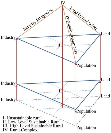
Figure 1.
Rural development and restructuring evolutionary model.
Specifically, the model uses each edge of the bottom triangle to represent the development level of the population factor, land factor, and industry factor in a certain time period, and measures the coupling and coordination level of the factors through their point characteristics [42]. The side edges represent the comprehensive development level of the rural areas in that period time and researches the restructuring degree of the rural areas by comparing the comprehensive development levels of the rural areas in different time periods. When the rural development is at stage I, although the development of each element is relatively coordinated, the comprehensive development level of the rural area is low, which is called unsustainable rural. When the rural development is at stage II, the rural area is initially restructured and the development level of the rural area is improved, but it is still low, which is called low-level sustainable rural. When the rural development is continued to stage III, the degree of restructuring of the rural area is enhanced and the comprehensive development level of the rural area is higher, which is called high-level sustainable rural. Finally, the level of coupling and coordination of all elements and the level of comprehensive development of the rural area are at a high level, and the rural area is in a relatively stable state, which is called the rural complex [43]. In this process, there will be three states between development and restructuring: the level of development is synchronized with the degree of restructuring, the level of development is higher than the degree of restructuring, and the degree of restructuring is higher than the level of development.
3. Materials and Methods
3.1. Study Area and Data
The Eco-Urban Agglomeration Around Poyang Lake (29°96′ N–30°04′ N, 113°65′ E–118°51′ E) is a strategic plan proposed by the Jiangxi Provincial Party Committee and the Provincial Government of China. At the end of 2015, the plan for the Eco-Urban Agglomeration Around Poyang Lake was approved by the Chinese government and improved the national development strategy of China. Its purpose is to protect and develop this area, making it a unique ecological zone with rapid economic development and coordinated urban and rural development scientifically and reasonably.
The study area included 56 counties covered by the Eco-Urban Agglomeration Around Poyang Lake Plan (2015–2030) (Figure 2). In 2020, the resident population of the area was 3 million, and the urbanization rate was 63.32%. The arable land area was 28,900 km2, constituting 31.31% of the regional area. Furthermore, the total value of GDP was CNY 1.77 trillion, of which the added value of primary industry constituted 14.55%. As a traditional agricultural production region in China, the areas covered by Eco-Urban Agglomeration Around Poyang Lake have diverse regional landscapes, varied rural resource and development types, and unique rural production, ecology, and life functions. Furthermore, as one of the most important members of the urban agglomeration in the middle reaches of the Yangtze River, the area has an obvious urban-rural dual structure, uneven urban-rural development, and insufficient rural development. The area is aimed at building a green urbanization model area, which is of great significance for exploring the temporal and spatial evolution pattern and characteristics of rural restructuring in the Great Lake Basin, as well as the characteristics of rural development and restructuring paths in traditional agricultural areas.
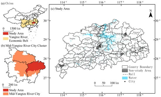
Figure 2.
The study area: (a) locations in China; (b) locations in Mid-Yangtze River City Cluster; (c) basic information of the study area.
With reference to related study [44], urban counties with urbanization rates over 80 % were excluded, and 56 counties were finally identified as the study area, and the study period was from 2000 to 2020. To ensure the consistency of the study units in different study periods, the administrative division of Jiangxi in 2020 prevailed. The basic geographic data were obtained from the Resource and Environment Science Data Center of the Chinese Academy of Sciences (https://www.resdc.cn, accessed on 16 May 2022), the socio-economic statistics were obtained from the China County Statistical Yearbook, the Jiangxi Statistical Yearbook and the statistical yearbooks of each county (2000, 2005, 2010, 2015, 2020), land use data were obtained from GlobeLand30 (2000, 2010, 2020) (http://www.globeland30.org, accessed on 16 May 2022) and Landsat TM image interpretation data (2005, 2015) provided by the Resource and Environment Science Data Center of the Chinese Academy of Sciences.
3.2. Methods
3.2.1. Measurement of the Rural Development Level
The evaluation index system of the rural development level (RDL) was constructed with the three key elements of population, land, and industry (Table 1). The entropy value method was used to measure the rural population development level (RDLP), rural land development level (RDLL), rural industry development level (RDLI), and rural comprehensive development level (RDLC) in the study area from 2000 to 2020. In reference to existing studies and the unique characteristics of this study area, the urbanization rate, non-farm employment rate, and population outflow rate were selected to reflect RDLP. RDLP is higher when the urbanization rate is higher, the nonfarm employment rate is higher, and the outflow rate is lower [13,17]. The per capita arable land area, per capita rural construction land area, and per capita grain cultivation area were selected to reflect RDLL. RDLL is higher when the arable land area per capita is higher, the rural built-up land area per capita is lower, and the food cultivation area per capita is higher [4,19]. The proportion of agricultural output value, agricultural production efficiency, and agricultural mechanization level were used to reflect RDLI. RDLI is higher when the proportion of agricultural output is lower, agricultural production is more efficient and the level of agricultural mechanization is higher. [17] (Table 1). The entropy method was used to measure the level of rural development, which, as an objective evaluation method, can help effectively overcome the superposition of information among indicators [45]; the formula is as follows:
where G denotes the level of rural development; is the standard value of the index; is the information entropy of the indicator; denotes the weight; denotes the information entropy; denotes the weight of rural i under indicator j; and z denotes the number of study units. The extreme value method was used to make the data dimensionless.

Table 1.
Evaluation index system of RDL.
3.2.2. Measurement of the Rural Restructuring Degree
Rural restructuring is a process of quantitative to qualitative change of the elements of the rural regional system and has an obvious chronological evolution [1]. The RDL at the beginning and ending of the study period was used to determine the degree of restructuring. Based on the evaluation index system of RDL, the rural population restructuring degree (RRDP), the rural land restructuring degree (RRDL), the rural industrial restructuring degree (RRDI), and the rural comprehensive restructuring degree (RRDC) were measured by analyzing the degree of change of each index. The formula is as follows:
where, anddenote the development levels of indicator i at the ending and beginning of the period.
4. Results
4.1. Spatio-Temporal Characteristics of RDL
The rural development level in the study area has greatly improved in the past two decades, and the rural development level gap, although existing, is narrowing. Especially from 2010 onward, the rural development level has improved by an average of 0.133, and some rural areas have reached a rural development level of 0.500 (Figure 3a). In terms of the development level of each element, the rural development of the study area has undergone a transformation process from land element-led to industry elements-led and finally to population elements-led (Figure 3b). The RDL was classified into six classes by using the Jenks classification tool in ArcGIS 10.6 software to obtain the geographical pattern of rural development in the study area between 2000 and 2020 (Figure 4).
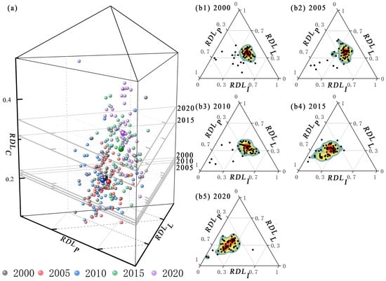
Figure 3.
Rural Development Levels by County between 2000 to 2020 (a), level of element development in each period (b1–b5). Note: The largest point in each color indicates the average value of rural development for that year.
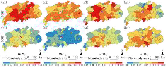
Figure 4.
Spatio-temporal patterns of RDL. RDLC, RDLP, RDLL, RDLI in 2020 (a1–a4). RDLC, RDLP, RDLL, RDLI in 2000 (b1–b4).
The RDLC improved greatly between 2000 and 2020. Furthermore, the distribution of high-value and low-value areas was relatively stable, indicating a spatial pattern of “high in the middle and low around” during both years. The high-value area was centered on Nanchang, counties around Poyang Lake, and counties near the main traffic lines; the low-value area was observed around the study area, mostly in the area with higher elevation and poorer natural conditions. In 2000, the RDLC was mostly below 0.30, with only Linchuan, Xiajiang, and Qingshanhu having an RDLC above 0.30; in 2020, 42 counties had an RDLC above 0.30, constituting 75% of the study area, indicating that the RDLC has greatly improved.
The RDLP is rapidly increasing. In 2000, 46 counties had an RDLP below 0.08, constituting 82% of the study area, and only Changjiang and Qingshanghu had an RDLP above 0.16. In 2020, 36 counties had an RDLP above 0.16, constituting 64% of the study area, and none of the counties had an RDLP below 0.08, mainly forming a high-value area for population development along the Shanghai-Kunming Railway. The level of population development and its changes reflect the richness of human resources to a certain extent. The increase in the RDLP between 2000 and 2020 may be attributed to the increase in the level of urbanization, the widening of labor force employment channels, and the return of the outgoing population in some areas during this period.
The RDLL has improved significantly. In 2000, 47 counties had an RDLL below 0.10, constituting 84% of the study area, and the high-value areas were scattered. In 2020, 20 counties had an RDLL above 0.10, constituting 54% of the study area, and the high-value areas were connected to patches on an original basis and expanded to Jiujiang and Nanchang. The level of and change in land development reflect the structure of land resource use and the tension between human and land. The high-value area has a low percentage of land under non-agriculture use and a rich rural land resource. The low-value area has a higher percentage of land under non-agriculture use, a tighter land resource, and more intensive land use.
Furthermore, the RDLI has declined. In 2000, the RDLI was roughly higher in the south than that in the north and more balanced in the east and west. In 2020, the RDLI was lower in the east than in the west and the gap between the north and the south was narrow. High-value areas clustered around Nanchang, and low-value areas expanded to the periphery based on the original. The number of counties with an RDLI lower than 0.05 has increased from 6 to 15. The industrial development reflects the development condition of agriculture, which is subject to the influence of labor force and comparative income in the development process. The development of secondary and tertiary industries also leads to the decline of the status of local agriculture and the lower level of industrial development.
4.2. Spatio-Temporal Characteristics of RRD
Between 2000 and 2020, the RRD in the study area improved greatly. The RDDC between 2000 and 2020 was 0.060. In terms of each element, RRDI is the largest with 0.04, RRDP is the second largest with 0.019, and RRDL is the smallest with 0.016. Rural restructuring of the study area displayed a wave-like advancement. The structure and degree of restructuring of each element change with the acceleration of the industrial restructuring trend, slowing down of the population restructuring trend, and slowing down of the land restructuring trend. We measure the restructuring degree of each element in four study periods (between 2000 and 2005, between 2005 and 2010, between 2010 and 2015 and between 2015 and 2020) and analyze the evolution of the degree of rural restructuring in different periods (Figure 5).
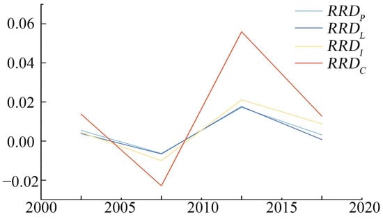
Figure 5.
RRD Index from 2000 to 2020.
The mean values of the RRDC for the four periods were 0.014, −0.023, 0.056, and 0.013, except for the periods 2005 to 2010, and were positively restructured, with restructuring being the most remarkable from 2010 to 2015. The high-value areas of RRDC show a characteristic from scattering to clustering, with the high-value areas of restructuring sporadically between 2000 and 2005; between 2005 and 2010, they are located at the edge of the study area; between 2010 and 2015, they expand toward the center based on the previous period; they are located at the central and southeastern part between 2015 and 2020. Overall, the average value of the RRDC between 2000 and 2020 is 0.060, and 57.14% of the counties had a restructuring degree higher than the average value, with the high-value areas being widely distributed in Shangrao, Yichun, and Jingdezhen and some rural in Jiujiang, and Pingxiang (Figure 6).
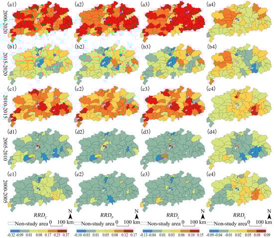
Figure 6.
Spatio-temporal patterns of RRD. RRDC, RRDP, RRDL, RRDI between 2000 and 2020 (a1–a4). RRDC, RRDP, RRDL, RRDI between 2015 and 2020 (b1–b4). RRDC, RRDP, RRDL, RRDI between 2010 and 2015 (c1–c4). RRDC, RRDP, RRDL, RRDI between 2005 and 2010 (d1–d4). RRDC, RRDP, RRDL, RRDI between 2000 and 2005 (e1–e4).
The mean values of the RRDP for the four study periods were 0.005, −0.006, 0.017, and 0.003, respectively. The restructuring of high-value areas indicated the characteristics of decentralization, followed by clustering and decentralization. Between 2000 and 2005, only three counties were restructured to a more drastic extent; between 2005 and 2010, new high-value areas appeared around the original high-value areas; between 2010 and 2015, contiguous high-value areas appeared, in a roughly “Z” shape throughout the study area; between 2015 and 2020, high-value areas were scattered in the central and southeastern parts of the study area. In general, the mean value of the RRDP between 2000 and 2020 is 0.019, and 64.29% of the counties have a degree higher than the mean value. The high-value areas are mainly distributed in Shangrao, Jingdezhen and Yingtan and some counties in the southwest. The RRDP is lower in Jiujiang and Yichun border counties.
The mean values of the RRDL for the four study periods were 0.004, −0.007, 0.018, and 0.001, respectively. The restructuring of high-value areas exhibited the characteristics of scattering and then clustering, with a sporadic distribution of high-value areas between 2000 and 2010; the emergence of high-value centers with scattered distribution between 2010 and 2015; and the centralized distribution of high-value centers between 2015 and 2020. Overall, the mean value of the RRDL between 2000 and 2020 was 0.016, and 66.07% of the counties had a degree higher than the mean value, with high-value areas located mainly in the eastern counties of the study area and lower degrees of restructuring in the western counties.
The mean values of the RRDI for the four study periods were 0.004, −0.010, 0.021, and 0.009, respectively. The restructuring of high-value area exhibited a migration trend from southeast to northwest. The high-value area was distributed in the southeastern counties of the study area between 2000 and 2010. The migration trend started between 2010 and 2015, and the restructuring of the high-value center occurred in the central part of the study area. The high-value center was located at the northwestern counties between 2015 and 2020. Overall, the average value of the RRDI between 2000 and 2020 was 0.024, and 4.64% of the counties have a degree higher than the average value, with the high-value areas at Yichun, Jiujiang, and some counties in Shangrao and Jingdezhen and the other regions have a lower RRDI.
4.3. Rural Development and Reconstruction Type Characteristics
The combined RRDC from 2000 to 2020 and RDLC during 2020 were used to identify the characteristics of rural development and restructuring types. Taking the mean value of two indexes as the coordinate origin and adding the Y = X function, the plane right angle coordinate system was classified into six zones, and the type of rural development and restructuring of the study area was classified by the point characteristics of the county in the coordinate system. The results demonstrated 14 types I, 2 types II, 17 types III, 9 types IV, 5 types V, and 9 types VI zones (Figure 7).
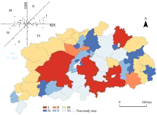
Figure 7.
Rural development and restructuring type.
The RDLC and the RRDC in type I zones were higher than the average value, and rural development was ahead of rural restructuring. This type was mainly observed in the central of the study area, with the regional characteristics of flatter topography, lower elevation, higher socio-economic development level, and thereby higher rural development level. However, rural restructuring in Type 1 zones needs to be further strengthened.
The RDLC and the RRDC in Type II zones were higher than the average value, and rural restructuring was ahead of rural development. This type was mainly observed in Lingshan and Yongxiu, located at the border of Type I, with better socio-economic conditions and higher development level but a higher degree of rural restructuring due to their better transportation conditions.
Type III zones have a lower-than-average RDLC and a higher-than-average RRDC. This type was mainly observed in the mountainous areas to the west and east of the study area, with poorer natural conditions and lower socio-economic development levels, leading to a lower level of rural development. The unique location adjacent to other provinces led to these rural areas being more susceptible to the influence of adjacent areas and a higher degree of rural restructuring.
The RDLC and the RRDC in Type IV zones were lower than the average, and rural restructuring was ahead of rural development. This type was scattered in the southwestern, north-central, and eastern parts of the study area, with different characteristics in each county, namely Dexing, Hengfeng, Guangfeng, and Fenyi, where the mountainous and hilly topographic conditions had been restricting rural development and restructuring. Hukou, Duchang, and Gongqingcheng, which are adjacent to Poyang Lake and have a fragile ecological environment, and Qingshanghu and Changjiang, which are located at the edge of the city, were affected by the siphoning effect of the main cities and lagged in rural development and restructuring, in addition to being affected by urbanization and industrialization, in these regions, the rural restructuring process was ahead of rural development.
Both the RDLC and the RRDC in Type V zones were below the average, and rural development was ahead of rural restructuring. This type was observed in Yiyang, Lushan, Xinjian, Yushui, and Xiangdong, the town development level was high, and the urban-rural integration level was lower, resulting in low rural development and restructuring.
The RDLC in Type VI zones was higher than the average, and the RRDC was below the average value. This type was concentrated in the central and southern parts of the study area. The superior natural and socio-economic conditions led to rapid rural development; however, rural development was relatively stable, and the degree of restructuring was low.
In general, the formation of each rural development type reflects the role of geographical factors and is the result of the joint action of topographic conditions, location conditions, economic development, and many other factors, reflecting the evolution process of the regional human-earth relationship. Type I and Type III were the main types of rural development and restructuring in the study area, and these two types constitute 55.36% of the number of study units. These two types with concentrated distribution, both were more similar in the RRDC, but the RDLC of the former was higher than the latter, implying that the level of rural development within the study area was still heterogeneous. Most of the rural area types have been in the process of restructuring, and the heterogenous has been smaller. Rural development and restructuring in the study area are typical of those of less-developed regions in China.
5. Discussion
5.1. The Relationship between Rural Development and Rural Reconstruction
Rural development is a static concept that measures the development state of a rural regional system at a certain point in time, and rural restructuring is a dynamic concept, and the degree of intensity of rural restructuring varies with time. The rural restructuring degree can be obtained by comparing the state of rural development at the end and beginning of the study period to obtain [46]. The rural restructuring degree is closely related to the rural development level in the study period, but there may be a misalignment between the rural development level and the rural restructuring degree [17]. In this process, there will be three states between development and restructuring: the level of development is synchronized with the degree of restructuring, the level of development is higher than the degree of restructuring, and the degree of restructuring is higher than the level of development. That is, the RDLC in 2020 is 0.347, but the RRDC is 0.013; while the RDLC in 2015 is 0.209, but the RRDC is 0.056.
5.2. Features of Rural Restructuring
Relevant research has indicated that rural development and restructuring is a complex and non-linear process, it can be divided into different stages, including the initial stage, development stage, stabilization stage, and stabilization stage [15,47,48]. The findings of this study indicate that rural restructuring is characterized by wave-like advancement, which is consistent with the findings of previous studies. The RRDC between 2020 and 2000 is 0.060, but at different stages, RRDC presents different characteristics. RRDC was 0.014 between 2000 and 2005, then dropped to −0.023 between 2000 and 2005, then rose again to 0.056, then dropped again to 0.013 between 2000 and 2005.
In addition, in the process of rural restructuring, the elements show different characteristics. Population, land, and industry are the three key elements of rural development and restructuring, as well as the main elements of social, natural, and economic systems. The population is affected by, and benefits from, rural development and restructuring; the land is an important spatial carrier, and the industry is the driving force and foundation [49]. The elements in the rural development and restructuring process are not perfectly balanced. At a certain stage, a particular element may be ahead or backward [50,51]. In the rural restructuring process in the study area, the land element is dominant at first, and then the industrial element is dominant for a short period time. After 2010, the population element has been gradually dominating over other elements.
5.3. Space Zoning and Policy Control
Rural development and restructuring is characterized by stages [52,53], at different stages, the key elements are different. The land element plays a greater role in the initial stage of rural development and restructuring, in which the land use structure should be optimized to avoid an expansive land economy. In the second stage of rural development and restructuring, industrial elements gradually take up a major role, which should accelerate the industrial development of rural areas, optimize the industrial structure, and accelerate the development of industrial integration. The third stage is population-oriented. After the land improvement and industrial development, we need to accelerate the improvement of rural human resources, optimize the population structure, and train a group of rural capable people.
By classifying the types and stages of rural development and reconstruction in the study area, we suggest that the local government should adopt different policy measures for different rural areas [54,55]. For Types IV, V, and VI with a low degree of rural restructuring, we should accelerate the development of the rural industrial system and mechanisms compatible with urbanization; promote the local urbanization of population; optimize the “production-life-ecology space”; accelerate the deep integration of rural industries; and improve regional functions. For Types I, II, and III with a high degree of rural restructuring, we should strengthen the construction of rural talents, attract talents to return to villages for employment, cultivate numbers of new farmers, and promote rural land and industrial restructuring with demographic factors.
Due to the long research period, the inclusion of numerous index data, and the lack of some statistical data in rural area, only a few key indicators with strong representativeness could be selected, which may introduce some errors in the analysis results. Second, there is no study of the inter-evolutionary and intrinsic mechanisms of interaction between population, land, and industry. In addition, this paper only analyzes the three key elements within the rural regional system, lacks attention to the significant diversity and dynamism of the current rural areas, and does not investigate the mutual flow and interaction between various types of multiple heterogeneous subjects in the process of rural development and restructuring. In the future, we will choose typical regions of rural development and restructuring and make further research on the differences in rural development and restructuring patterns and mechanisms among different types of districts.
6. Conclusions
This paper considers population, land, and industry as the key elements; builds a rural development and restructuring evolutionary model; analyzes the degree of rural restructuring by evaluating the level of rural development; considers the areas covered by Eco-Urban Agglomeration Around Poyang Lake as the research areas; and analyzes the spatiotemporal pattern and characteristics of rural development and restructuring. The main research findings include the following three aspects:
In general, the level of rural development in the study area is rapidly improving, and the regional development gap is narrowing. The average value of the RDLC in the study area increased from 0.218 to 0.347. In terms of each element, rural development in the study area has undergone a transformation process from being led by the land element to the industrial element and finally to the population element. The development level of the population element is the fastest and most rapidly improving along the Shanghai–Kunming Railway. Followed by the development level of land element, the development level of the western part of the study area is high, whereas that of the eastern part is low. The development level of industrial element is low, and the spatial pattern is relatively stable. The development level of the plain area along the lake is high and that of the surrounding mountainous area is low.
The degree of rural restructuring in the study area is high; however, the degree of restructuring is unbalanced. From the perspective of time, rural restructuring indicates the characteristics of a wave-like advance. From the perspective of each element, the restructuring process of the population element is relatively steady, with RRDP decreasing from 0.005 to 0.003. The restructuring of the land element is relatively slower, with RRDL decreasing from 0.004 to 0.001. The degree of restructuring of the industry element is more variable, with RRDI increasing from 0.004 to 0.021 and then decreasing to 0.009.
Based on the analysis results of RDL and RRD, rural development and restructuring of the study area is classified into six zones. The spatial distribution characteristics of each zone are the result of the interaction region between human and earth. Types I, III, and V show a distinct spatially clustered distribution, while Types II, IV, and VI are relatively dispersed. In terms of numbers, among these types, Type I and Type III are the main zones, accounting for 55.36% of all types and exhibiting a concentrated distribution.
Author Contributions
Conceptualization, D.Y. and X.Y.; methodology, D.Y. and X.Y.; software, D.Y.; validation, D.Y., L.Z. and X.Y.; formal analysis, D.Y.; investigation, D.Y. and X.Y.; resources, D.Y.; data curation, D.Y. and X.Y.; writing—original draft preparation, D.Y. and X.Y.; writing—review and editing, D.Y. and L.Z.; visualization, D.Y.; supervision, L.Z. and X.Y.; project administration, D.Y. and L.Z.; funding acquisition, L.Z. All authors have read and agreed to the published version of the manuscript.
Funding
This research was funded by the National Natural Science Foundation of China (Grant No. 41661114) and Jiangxi Normal University Graduate Innovation Fund Project (Grant No. YJS2021015).
Institutional Review Board Statement
Not applicable.
Informed Consent Statement
Not applicable.
Data Availability Statement
The data presented in this study are available on request from the corresponding author.
Conflicts of Interest
The authors declare no conflict of interest.
References
- Long, H.; Liu, Y. Rural Restructuring in China. J. Rural Stud. 2016, 47, 387–391. [Google Scholar] [CrossRef]
- Tu, S.; Long, H. Rural Restructuring in China: Theory, Approaches and Research Prospect. J. Geogr. Sci. 2017, 27, 1169–1184. [Google Scholar] [CrossRef]
- Liu, Y. Research on the urban-rural integration and rural revitalization in the new era in China. Acta Geogr. Sin. 2018, 73, 637–650. [Google Scholar]
- Long, H. Land Consolidation: An Indispensable Way of Spatial Restructuring in Rural China. J. Geogr. Sci. 2014, 24, 211–225. [Google Scholar] [CrossRef]
- Hu, X.; Li, H.; Zhang, X.; Yuan, Y. On the re-cognition of rural definitions. Acta Geogr. Sin. 2020, 75, 398–409. [Google Scholar]
- Liu, Y.; Yan, B.; Wang, Y. Urban-Rural Development Problems and Transformation Countermeasures in the New Period in China. Econ. Geogr. 2016, 36, 1–8. [Google Scholar]
- Liu, Y.; Li, Y. Revitalize the World’s Countryside. Nature 2017, 548, 275–277. [Google Scholar] [CrossRef]
- Long, H.; Tu, S. Rural Restructuring: Theory, Approach and Research Prospect. Acta Geogr. Sin. 2017, 72, 563–576. [Google Scholar]
- Long, H.; Tu, S.; Ge, D.; Li, T.; Liu, Y. The Allocation and Management of Critical Resources in Rural China under Restructuring: Problems and Prospects. J. Rural Stud. 2016, 47, 392–412. [Google Scholar] [CrossRef]
- Lobley, M.; Potter, C. Agricultural Change and Restructuring: Recent Evidence from a Survey of Agricultural Households in England. J. Rural Stud. 2004, 20, 499–510. [Google Scholar] [CrossRef]
- Long, H.; Zou, J.; Pykett, J.; Li, Y. Analysis of Rural Transformation Development in China since the Turn of the New Millennium. Appl. Geogr. 2011, 31, 1094–1105. [Google Scholar] [CrossRef]
- Li, Y.; Yan, J.; Wu, W.; Liu, Y. The process of rural transformation in the world and prospects of sustainable development. Prog. Geogr. 2018, 37, 627–635. [Google Scholar]
- Yu, B.; Li, Y.; Zhu, Y.; Zhuo, R.; Zeng, J. Characteristics and regional model of rural restructuring in main agricultural production regions in Central China: A case study of Jianghan Plain. J. Nat. Resour. 2020, 35, 2063. [Google Scholar] [CrossRef]
- Li, Y.; Liu, Y.; Long, H. Characteristics and Mechanism of Village Transformation Development in Typical Regions of Huang-Huai-Hai Plain. Acta Geogr. Sin. 2012, 67, 771–782. [Google Scholar]
- Zhou, L.; Wang, L.; Su, K.; Bi, G.; Chen, H.; Liu, X.; Yang, Q. Spatiotemporal Characteristics of Rural Restructuring Evolution and Driving Forces in Mountainous and Hilly Areas. Land 2022, 11, 848. [Google Scholar] [CrossRef]
- Li, Y.; Liu, Y.; Long, H.; Guo, Y. Village transformation development, resources and environment effects and their optimal regulation in the metropolitan suburbs: The case of Beicun in Shunyi District, Beijing. Acta Geogr. Sin. 2013, 68, 825–838. [Google Scholar]
- Tu, S.; Zheng, Y.; Long, H.; Wan, S.; Liang, X.; Wang, W. Spatio-temporal pattern of rural development and restructuring and regional path of rural vitalization in Guangxi, China. Acta Geogr. Sin. 2020, 75, 365–381. [Google Scholar]
- Jain, M.; Korzhenevych, A.; Hecht, R. Two Decades of Urban and Rural Restructuring in India: An Empirical Investigation along Delhi-Mumbai Industrial Corridor. Habitat Int. 2021, 117, 102444. [Google Scholar] [CrossRef]
- Li, H.B.; Zhang, X.; Wu, Q.; Wang, Y. Characteristics and Mechanism of Rural Settlements Spatial Reconstruction in Developed Areas—A Case Study of Southern Jiangsu. J. Nat. Resour. 2015, 30, 591–603. [Google Scholar]
- Chen, Y.; Xi, E.B. The spatial evolution and restructuring of rural settlements in Jiangnan hilly region: A case study in South Jiangxi. Geogr. Res. 2016, 35, 184–194. [Google Scholar]
- Tu, S.; Long, H.; Zhang, Y.; Ge, D.; Qu, Y. Rural Restructuring at Village Level under Rapid Urbanization in Metropolitan Suburbs of China and Its Implications for Innovations in Land Use Policy. Habitat Int. 2018, 77, 143–152. [Google Scholar] [CrossRef]
- Yang, R. The actor-network perspective on the reconstruction process and internal mechanism of typical Taobao villages in the Pearl River Delta region. Acta Geogr. Sin. 2021, 76, 3076–3089. [Google Scholar]
- Gong, L.; Yang, R.; Yang, F. Rural Economic Spatial Reconstruction Process and Mechanism in Pearl River Delta Region Driven by Rural Land Capitalization. Econ. Geogr. 2021, 41, 152–161. [Google Scholar]
- Gao, C.; Cheng, L. Tourism-Driven Rural Spatial Restructuring in the Metropolitan Fringe: An Empirical Observation. Land Use Policy 2020, 95, 104609. [Google Scholar] [CrossRef]
- Ding, J.; Wang, Z.; Yu, F.; Liu, Y. Targeted poverty alleviation drives the process and mechanism of rural reconstruction: A case study of Shibadong Village. Acta Geogr. Sin. 2021, 76, 2568–2584. [Google Scholar]
- Hedlund, M.; Lundholm, E. Restructuring of Rural Sweden—Employment Transition and out-Migration of Three Cohorts Born 1945–1980. J. Rural Stud. 2015, 42, 123–132. [Google Scholar] [CrossRef]
- Tan, L.; Chen, L. The driving mechanism and path analysis of the coupling development of rural spatial reconstruction and land use transformation. J. Nat. Resour. 2022, 37, 1829. [Google Scholar] [CrossRef]
- Xu, C.; Qian, C.; Yang, W.; Li, B.; Kong, L.; Kong, F. Spatiotemporal Pattern of Urban-Rural Integration Development and Its Driving Mechanism Analysis in Hangzhou Bay Urban Agglomeration. Int. J. Environ. Res. Public. Health 2022, 19, 8390. [Google Scholar] [CrossRef]
- Jiang, L.; Luo, J.; Zhang, C.; Tian, L.; Liu, Q.; Chen, G.; Tian, Y. Study on the Level and Type Identification of Rural Development in Wuhan City’s New Urban Districts. ISPRS Int. J. Geo-Inf. 2020, 9, 172. [Google Scholar] [CrossRef]
- Hu, S.; Yu, B.; Wang, M. Rural restructuring and transformation: Western experience and its enlightenment to China. Geogr. Res. 2019, 38, 2833–2845. [Google Scholar]
- Ren, Y.; Yansui, L.; Hualou, L.; Yijun, Z. Research progress and prospect of rural transformation and reconstruction in China: Paradigms and main content. Prog. Geogr. 2015, 34, 1019–1030. [Google Scholar]
- Ren, Y.; Yanchun, C. Change in key research area and prospect of Chinese rural geography. Prog. Geogr. 2018, 37, 601–616. [Google Scholar]
- Hoggart, K.; Paniagua, A. What Rural Restructuring? J. Rural Stud. 2001, 17, 41–62. [Google Scholar] [CrossRef]
- Yang, X.; Wang, Z.; Chen, Y.; Lei, J.; Zhang, A. Analysis of Structureal Characteristics of Poyang Lake Ecological Agglomeration in Jiangxi Province under Different Scales: A Study Based on Data of Passenger and Train Movements. Mod. Urban Res. 2019, 12, 90–95. [Google Scholar]
- Liu, Y.; Zhou, Y.; Li, Y. Rural regional system and rural revitalization strategy in China. Acta Geogr. Sin. 2019, 74, 2511–2528. [Google Scholar]
- Li, X.; Ma, X.; Hu, M. The mutual feedback mechanism of human-land-industry factors of the rural regional system. Geogr. Res. 2022, 41, 1981–1994. [Google Scholar]
- Liu, Z.; Liu, S.; Jin, H.; Qi, W. Rural Population Change in China: Spatial Differences, Driving Forces and Policy Implications. J. Rural Stud. 2017, 51, 189–197. [Google Scholar] [CrossRef]
- Liu, Y. Introduction to Land Use and Rural Sustainability in China. Land Use Policy 2018, 74, 1–4. [Google Scholar] [CrossRef]
- Zhu, F.; Zhang, F.; Ke, X. Rural Industrial Restructuring in China’s Metropolitan Suburbs: Evidence from the Land Use Transition of Rural Enterprises in Suburban Beijing. Land Use Policy 2018, 74, 121–129. [Google Scholar] [CrossRef]
- Zhang, R.; Zhang, X. Spatial–Temporal Differentiation and the Driving Mechanism of Rural Transformation Development in the Yangtze River Economic Belt. Sustainability 2022, 14, 2584. [Google Scholar] [CrossRef]
- Woods, M. Rural Geography III: Rural Futures and the Future of Rural Geography. Prog. Hum. Geogr. 2012, 36, 125–134. [Google Scholar] [CrossRef]
- Wan, H.; Mao, N.; Song, H.; He, Y.; Wang, Z.; Zhu, C. Type variability research of agro-ecosystem vulnerability in Yulin, Shaanxi, China, based on triangle method. J. DESERT Res. 2021, 41, 224–234. [Google Scholar]
- Li, L.; Qu, L.; Liu, Y. Research on identification method and application of rural regional multi-body system. Geogr. Res. 2019, 38, 563–577. [Google Scholar]
- Fang, C. Theoretical analysis on the mechanism and evolution law of urban-rural integration development. Acta Geogr. Sin. 2022, 77, 759–776. [Google Scholar]
- Cao, M.; Zheng, L.; Li, P.; Tian, Q.; Xu, J. The Dynamics of Farmers’ Livelihoods in the Lakeside Area of Poyang Lake and Its Influencing Factors. J. Jiangxi Norm. Univ. Sci. Ed. 2021, 45, 103–110. [Google Scholar]
- Long, H.; Tu, S. Theoretical thinking of rural restructuring. Prog. Geogr. 2018, 37, 581–590. [Google Scholar]
- Tu, S.; Long, H.; Zhang, Y.; Zhou, X. Process and driving factors of rural restructuring in typical villages. Acta Geogr. Sin. 2019, 74, 323–339. [Google Scholar]
- Zhang, J.; Yu, H.; Qiao, W.; Xu, Z.; Cheng, S. Progress of research on the transformation and restructuring of rural development in China. Prog. Geogr. 2022, 41, 896–904. [Google Scholar] [CrossRef]
- Li, Y.; Westlund, H.; Liu, Y. Why Some Rural Areas Decline While Some Others Not: An Overview of Rural Evolution in the World. J. Rural Stud. 2019, 68, 135–143. [Google Scholar] [CrossRef]
- Yang, Y.; Liu, Y.; Li, Y.; Li, J. Measure of Urban-Rural Transformation in Beijing-Tianjin-Hebei Region in the New Millennium: Population-Land-Industry Perspective. Land Use Policy 2018, 79, 595–608. [Google Scholar] [CrossRef]
- Cheng, M.; Liu, Y.; Jiang, N. Study on the spatial pattern and mechanism of rural population-land-industry coordinating development in Huang-Huai-Hai Area. Acta Geogr. Sin. 2019, 74, 1576–1589. [Google Scholar]
- Ma, L.; Chen, M.; Che, X.; Fang, F. Research on Population-Land-Industry Relationship Pattern in Underdeveloped Regions: Gansu Province of Western China as an Example. Sustainability 2019, 11, 2434. [Google Scholar] [CrossRef]
- Long, H.; Liu, Y.; Li, X.; Chen, Y. Building New Countryside in China: A Geographical Perspective. Land Use Policy 2010, 27, 457–470. [Google Scholar] [CrossRef]
- Belton, B.; Filipski, M. Rural Transformation in Central Myanmar: By How Much, and for Whom? J. Rural Stud. 2019, 67, 166–176. [Google Scholar] [CrossRef]
- Markey, S.; Halseth, G.; Manson, D. Challenging the Inevitability of Rural Decline: Advancing the Policy of Place in Northern British Columbia. J. Rural Stud. 2008, 24, 409–421. [Google Scholar] [CrossRef]


Publisher’s Note: MDPI stays neutral with regard to jurisdictional claims in published maps and institutional affiliations. |
© 2023 by the authors. Licensee MDPI, Basel, Switzerland. This article is an open access article distributed under the terms and conditions of the Creative Commons Attribution (CC BY) license (https://creativecommons.org/licenses/by/4.0/).