Abstract
The Three Gorges Dam project and other human activities, including regional urbanization and industrialization, have had a substantial influence on the biological environment of the Three Gorges Reservoir Area (TGRA). They have changed the surface land use pattern, disrupted ecosystem structure and function, and influenced changes in the value of ecosystem services. The human activity intensity (HAI) assessment model, the ecosystem services value (ESV) assessment model, and the bivariate spatial autocorrelation model were used based on the spatiotemporal evolution data of towns along the Yangtze River in the TGRA in 1995, 2000, 2005, 2010, 2015, and 2020. At the same time, the spatiotemporal impact of the HAI on land use patterns was evaluated and the magnitude of the spatiotemporal influences on the ESV was investigated. The findings demonstrate the following: (1) The TGRA’s higher reaches are occupied by forested land, while the middle and lower portions are characterized by agricultural land. Land change in the reservoir region has mostly featured transitions between wooded land, agricultural land, grassland, and building land during the last 25 years. Because of differences in natural geography and administrative divisions, the intensity of human activity in the TGRA changes throughout the Yangtze River, with higher intensity in Chongqing and lower intensity in Hubei. By comparing the ESV and the HAI and validating with Moran scatter plots, it was determined that there is a negative relationship between the value of ecosystem services and the intensity of human activities. (2) The ESV rose from CNY 1017.16 × 108 in 1995 to CNY 1052.73 × 108 in 2020, suggesting that the policies of converting farmland back into forests, eliminating outdated production capacity, and developing green industries, among other ecological conservation measures, are effective. (3) In the research area, the effect coefficient of HAI on ESV ranges from −0.02 to −0.032 to −0.031. This coefficient represents the correlation between the HAI and ESV and can preliminarily judge the change in the degree of correlation between the HAI and ESV. The increase in HAI leads to a decrease in the value of ecosystem services, and there is a clear negative spatial correlation between the two. The low human activity area and low ecosystem service value area in the Chongqing section have been transformed into a high ecosystem service value area through years of returning farmland to forest and ecological management measures for sustainable development.
1. Introduction
Human socioeconomic activities have become essential drivers and dominant forces in the new Anthropocene period, influencing the spatial patterns of human–land relationships and the services provided by natural ecosystems [1]. High-intensity and large-scale human activities, such as infrastructure development, urbanization, industrialization, and commercialization, have substantial effects on the pattern of the “human–nature community” (which includes mountain, river, forest, agricultural, lake, grassland, and desert systems) [2,3]. These actions affect ecosystem structure and function [4,5,6], reducing the capacity of ecosystem services and product supply [7,8,9]. This has resulted in a plethora of environmental challenges, such as ecosystem degradation [10], decreased biodiversity [11], pollution [12], and a deteriorating watershed hydrological environment [13], all of which pose hazards to regional residential environmental safety and socioeconomic development. According to the United Nations Environment Programme’s Living Planet Report 2022, the level of human activity has worsened the serious problems confronting the Earth’s natural ecosystems, with an average decline of 69% in wildlife populations over the last 50 years. The primary causes of this reduction are habitat degradation, development, invasive species, pollution, climate change, and diseases caused by human activity [14]. Exploring the spatiotemporal link between human activity intensity and ecological service capacity has therefore become a hot issue in global research.
International organizations have performed considerable joint research based on the idea of human–nature coexistence. The UNESCO Man and the Biosphere (MAB) Programme and its World Network of Biosphere Reserves (WNBR) have launched collaborative study and action in 727 protected areas in 131 nations across the world. The goal is to investigate the dynamic link between humans and nature and to create a wealthy society in which humans and the Earth’s biodiversity coexist peacefully. Furthermore, the Intergovernmental Science-Policy Platform on Biodiversity and Ecosystem Services (IPBES) undertakes valuations of ecosystem services among its 139 member countries around the world. Experts and scholars in subjects such as geography, ecology, and urban studies have been investigating the theoretical and methodological elements of the link between human activities and dynamic ecosystems in recent years. To understand this association, they have focused on conceptual frameworks, intrinsic traits, and functional mechanisms. Meanwhile, they have conducted an extensive empirical study based on quantitative evaluation analysis, taking into consideration the unique circumstances of many countries and areas. Scholars have investigated how human actions affect the structure and function of ecosystems on factors like land use [15,16,17], protected areas [18,19,20], biodiversity [21,22], water environment [23,24,25], climate [26,27,28], and landscape patterns [29,30]. They have taken into account both individual elements and the cumulative impact of several variables [31,32], including human activity and climate change. Scholars hope [33,34] to gain a better understanding of the function of human activities in ecosystem services by investigating spatiotemporal variations and interrelationships. The analysis and measurement of human activity intensity are primarily separated into two ways in research methods: the mathematical and physical index assessment method and the GIS-based spatial analysis method. Methods such as the vegetation index and human appropriation of net primary productivity are examples of the former [35,36]. For example, Chinese scholar Xie Gaodi used GIS-based methods to determine the ecosystem service value coefficients in China [37]. Subsequently, more scholars conducted various studies using GIS spatial research methods. Methods such as land type change, composite index, and human footprint are examples of the latter [38,39,40]. There are two techniques for analyzing and measuring ecosystem services: the value-equivalent assessment method based on ecosystem state features [41,42,43] and the material-equivalent assessment method based on ecological processes and functions [44,45]. Meanwhile, ecosystem service evaluation models include the Artificial Intelligence for Ecosystem Services (ARIES) model, the Social Values for Ecosystem Services (SoLVES) model, and the Integrated Valuation of Ecosystem Services and Tradeoffs (InVEST) model. The research methods employed to examine the dynamic relationship between the HAI and ESV have been expanded upon to include simulation methods such as the Markov-FLUS model and cellular automata as systems thinking and big data analysis, and spatial analysis techniques have improved and become more widely used.
In conclusion, tremendous progress has been made in the study of the correlation between the HAI and ESV. However, the existing research has certain drawbacks that need to be addressed further. On the one hand, earlier research has largely concentrated on densely inhabited places and economically developed metropolitan cities, with few studies on small-scale county-level towns. Previous studies, on the other hand, have largely examined the spatial association between the HAI and ESV from a perspective that lacks in-depth research on the extent of the HAI’s impact on the ESV.
Based on the current characteristics of sensitive and fragile ecosystem structure and function in the TGRA, the ecosystem service process is diverse and complex, and combined with the Three Gorges Project construction, high-speed urbanization, and other high-intensity human activities, the disturbance of ecosystem services in the TGRA was taken as the research object. The temporal and spatial data of 1995, 2000, 2005, 2010, 2015, and 2020 were selected to analyze the effects of the type and intensity of human socioeconomic activities on regional ecosystem services in the TGRA. The purposes of this study are the following: (1) to analyze the spatiotemporal trends of ESV, land use patterns, and human activity intensity in the TGRA at different periods; (2) to determine the correlational trend between the HAI and ESV; and (3) to evaluate the impact of the HAI on the regional ESV.
2. Study Area and Data Sources
2.1. Study Area
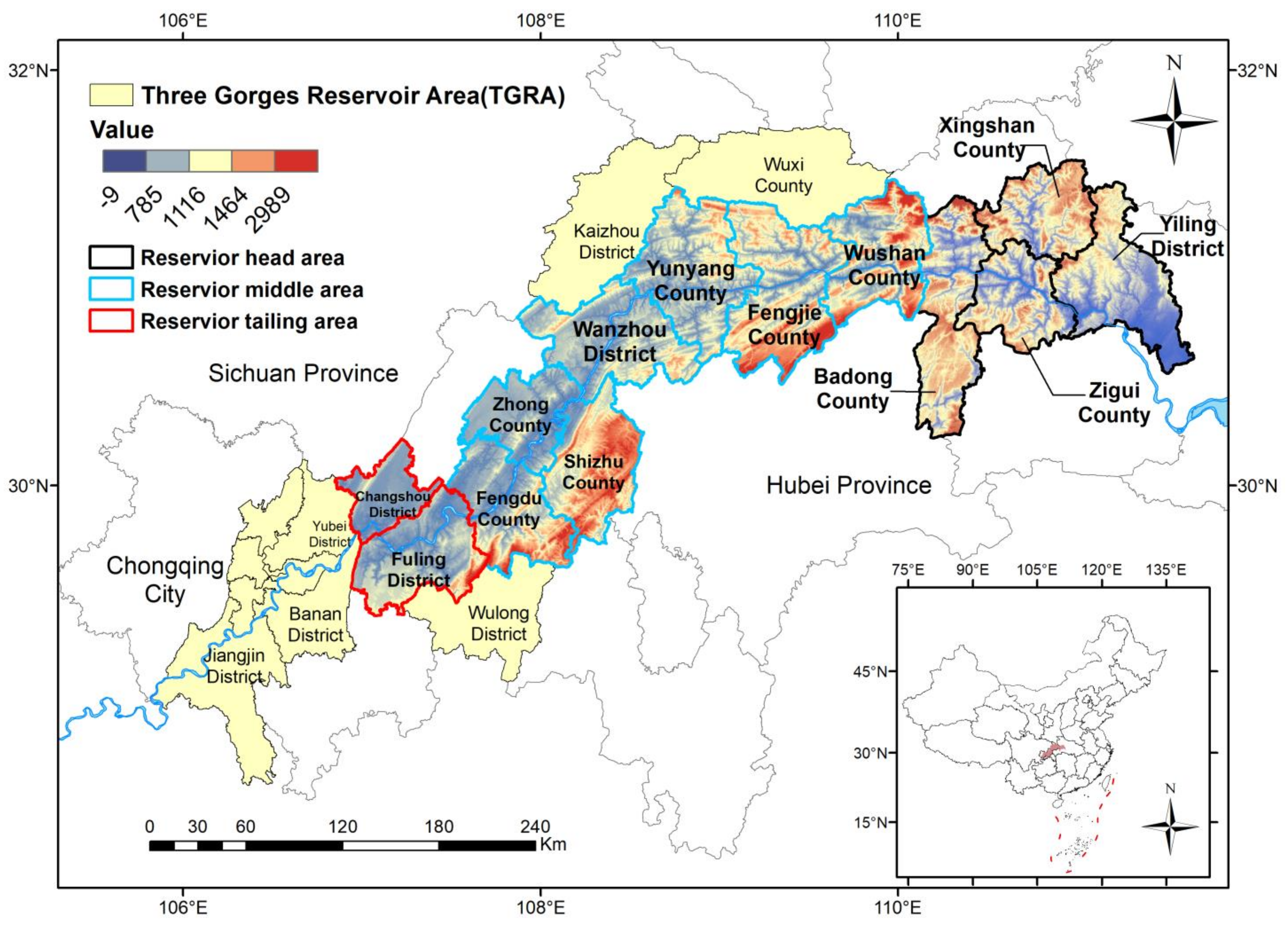
The TGRA is a unique geographical unit developed in the Yangtze River basin which resulted from the Three Gorges Project. It consists of 20 nations, cities, and districts in Hubei Province and Chongqing Municipality, covering an area of about 58,000 km2 [46]. The ecological environment in the region is sensitive and fragile, the contradiction between people and land is prominent, and the social and economic development is relatively lagging behind. In order to control and develop the Yangtze River basin, the construction of the Three Gorges Water Conservancy Project began in December 1994. Around October 2008, the offshore power station unit was put into operation, and the reservoir water level was 175 m [47]. In January 2010, the Three Gorges Project was completed and accepted after 16 years. After the completion of the project, the water level of the upper reaches of the Yangtze River basin increased by 113 m, involving the inundation of relocation counties in Yiling, Zigui, Xingshan, Badong, Wushan, Fengjie, Yunyang, Wanzhou, Zhong County, Shizhu, Fengdu, and Changshou, totaling 13 counties and districts in Chongqing Municipality, as well as the main urban area of Chongqing. A total of 1.31 million people were resettled and relocated with the intensification of human activities such as the construction of the Three Gorges Project and the urbanization and patterns of land use in the reservoir area changing significantly in stages, resulting in the decrease in the value of regional ecosystem services.
Based on the sustainable development goals and the development needs of ecological and environmental protection and restoration in the Yangtze River basin, the state has successively implemented the post-Three Gorges Work Plan (2009), main functional zoning (2010), and new urbanization (2014) in the TGRA. In 2016, the country implemented the Yangtze River Economic Belt Strategy to promote the ecological–social–economic development of cities along the Yangtze River basin. As a national key ecological function zone, the TGRA is also a key hub connecting the Chengdu-Chongqing urban agglomeration and the middle reaches of the Yangtze River urban agglomeration. Balancing the HAI and ESV and promoting the sustainable planning and management of land use have become the primary issues for the relevant departments in the TGRA.
The research region for this study was 13 counties and districts (small-scale towns) in the Yangtze River basin (Figure 1), with temporal bounds set at six distinct stages of the TGRA’s development (i.e., 1995, 2000, 2005, 2010, 2015, 2020).
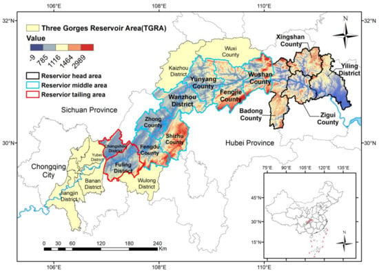
Figure 1.
Study Area.
2.2. Data Sources
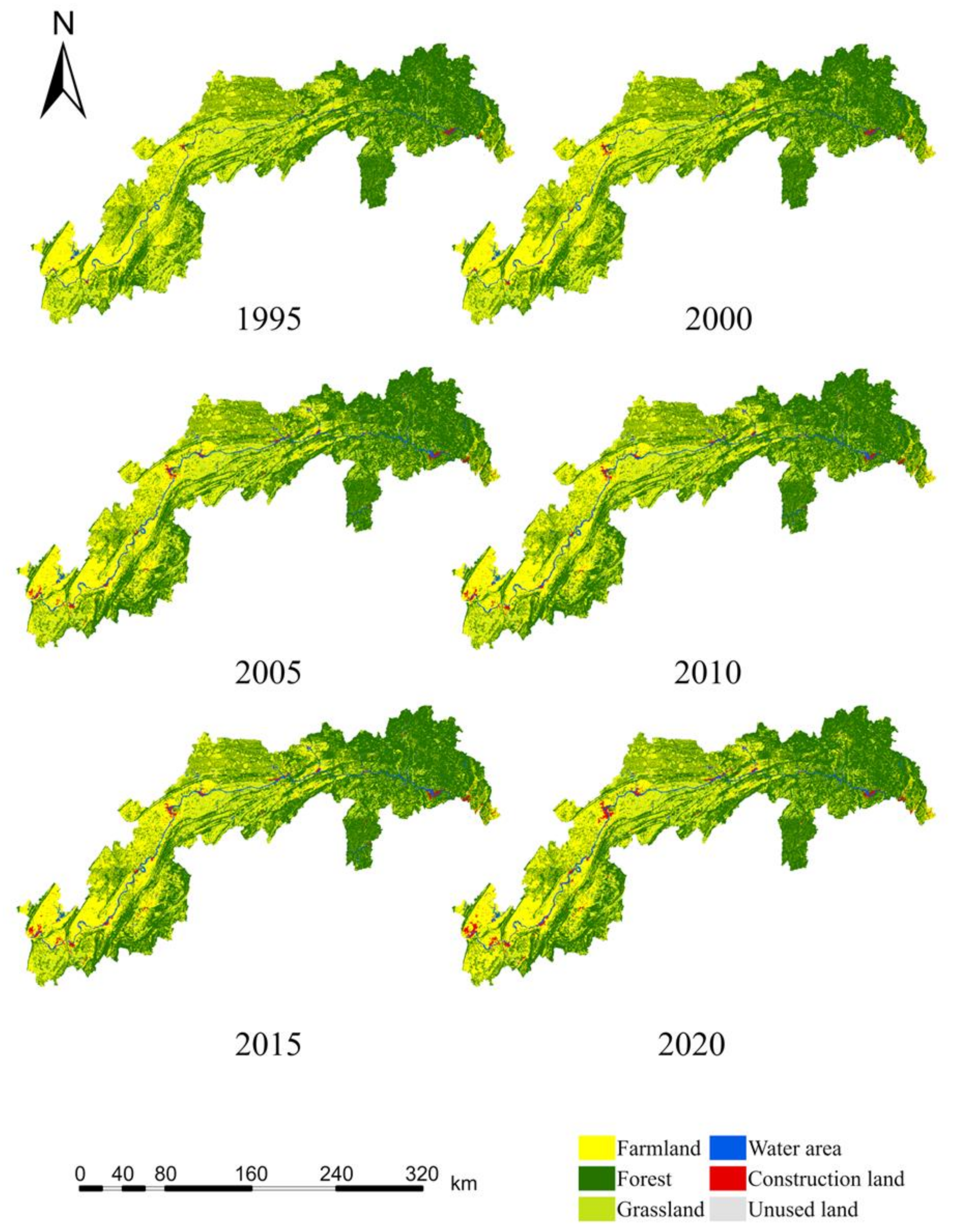
The Chinese Academy of Sciences Resource and Environmental Science Statistics Center (http://www.resdc.cn, accessed on 30 September 2023) provided land use statistics for the years 1995, 2000, 2005, 2010, 2015, and 2020. The data have a spatial resolution of 30 m × 30 m. The land types in the research region are classified into six groups based on the Chinese Academy of Sciences classification method of land use monitoring data and the classification standard for land use status in China (GB/T 21010-2017; Current land use classification. National Land and Resources Standardization Technical Committee: Beijing, China, 2017.): forest, farmland, grassland, construction land, water area, and unused land. Grain prize statistics included in the article came from the China Statistical Yearbook (2000–2020), the Hubei Statistical Yearbook (2000–2020), and the Chongqing Statistical Yearbook (2000–2020) (Figure 2).
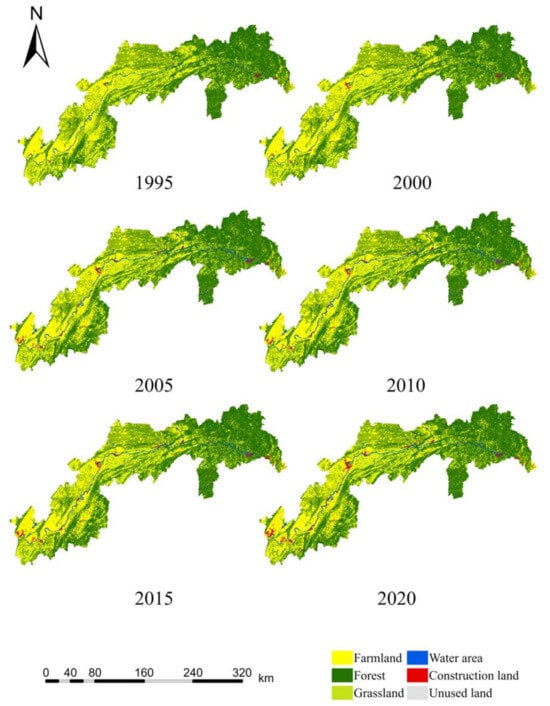
Figure 2.
Three Gorges Reservoir Area Land Use Type Map.
3. Methods
3.1. Ecosystem Service Valuation Model Adjustment Coefficient
3.1.1. Ecosystem Service Valuation Model
Costanza and others have presented approaches for valuing ecological services on a global scale based on extensive study [48]. The method consists of three steps: First, the ecosystems in the research region are classified using certain criteria. Second, different computation standards and methodologies are used to calculate the ecosystem service values of diverse land types. Finally, the data are summarized and aggregated to provide a regional ecosystem services valuation table
In Equation (1), ESV stands for the ecosystem service value, Ai represents the area of the i-th land type, and VCi represents the value coefficient, which represents the ESV per unit area of the i-th land type.
Domestic scholars, such as Xie Gaodi, have developed an analogous factor table for China’s terrestrial ecosystem service value based on the model presented by Costanza and others. Xie Gaodi and colleagues revised the comparable parameters for the ecosystem service value as their research progressed (Table 1) [49].

Table 1.
Equivalent Factor Table of Terrestrial Ecosystem Service Values in China (2007).
3.1.2. Modification of Ecosystem Service Value Assessment Method
- (1)
- Economic Calculation of Unit Grain Yield
The corresponding factor used in the study findings of Xie Gaodi and other scholars is the net value of grains, which is the value of real grains minus production expenses. It is calculated to be one-seventh of the value of grain yield [50].
Taking the crop cultivation situation in the TGRA into account, modifications are made to the economic value of one equivalent factor depending on the planted area and the production value of grains, tubers, and legumes. Furthermore, owing to volatility in agricultural product prices caused by economic variables, all agricultural production data are transformed into constant prices in the calculations using the benchmark year 1995 [51]. The Consumer Price Index (CPI) was created to modify grain prices, guaranteeing that agricultural product prices are unaffected by economic swings and currency value changes. The particular economic value of unit area grain yield is calculated using Formula (2):
In Formula (2), Et represents the economic value of unit area grain yield, Tt represents the total annual grain value in the study area, and Xt represents the annual grain sown area in the study area. Based on the China Statistical Yearbook from 1995 to 2020, the Hubei Statistical Yearbook from 1995 to 2020, and the Chongqing Economic Statistical Yearbook from 1995 to 2020, applying Formula (2), the average grain price per unit area of the TGRA from 1995 to 2020 was calculated as 1.56 CNY/kg, and the average grain yield in the TGRA was 4563 CNY/hectare. This yielded an Et value for the study area of 1016.89 CNY/hm2.
- (2)
- Regional Disparity Coefficient Adjustment
The magnitude of ecosystem service values within regions is influenced by differences in the geographical location, ecological environment, and regional biodiversity. To achieve higher accuracy in the outcomes of ecosystem service value assessment, a wide variety of parameters must be included throughout the evaluation process. Environmental variables, temporal features, geographical disparity factors, and varied assessment subject characteristics are among these factors. This study takes into account regional disparity coefficient modifications on a regional scale, using net primary productivity (NPP) rather than biomass. A ratio between the NPP value of a certain kind of vegetation’s natural vegetation net primary productivity potential and the average net primary productivity of all vegetation types was used to modify the regional disparity coefficient (Qt) of ecosystem services. The following is the particular calculating formula:
In Formula (3), Qt represents the regional disparity coefficient for the t-th year, NPP represents the net primary productivity of natural vegetation (t·hm−2·a−1), and NPPmean represents the average NPP of all vegetation types.
There are now several models available for predicting NPP. This work used the Thornthwaite Memorial model to estimate NPP based on the actual conditions of the study region and the availability of data.
In the formula, Z represents the actual annual evapotranspiration in the study area (mm), e represents the natural constant, H represents the average annual evapotranspiration in the study area (mm), t represents the average annual temperature in the study area (°C), and R represents the total annual precipitation in the study area (mm).
The NPP value of the TGRA and the regional difference coefficient Qt were estimated as 0.96 using Formulas (3)–(6) and the actual evapotranspiration, average temperature, and annual precipitation in the TGRA from 1995 to 2020.
3.1.3. Ecosystem Service Value Assessment Modified Model
Based on the preceding study, this work extensively references Xie Gaodi and others’ research efforts about the coefficient table of ecosystem service values in China. Adjustments to the Xie Gaodi value coefficients were made to incorporate the special development context of the Three Gorges Reservoir Area through the calculation of the economic value of crop yield (Et) and the modification of the regional difference coefficient (Qt). The updated regional ecosystem service value assessment model was created using a coefficient adjustment approach, as explained below:
In Formula (6), ESV represents the total value of ESV in the TGRA, Ai represents the area of the i-th land use type, VCi represents the numerical values corresponding to equivalent factors for the ESV functions of the i-th land use type. Et represents the economic value of the unit area of crop yield, Qt represents the regional difference coefficient correction value for ESV, and i denotes the number of land use types. Ultimately, the table of coefficients of ESV per unit area was derived (Table 2).

Table 2.
ESV Coefficients per Unit Area in the TGRA (CNY/×104 m2).
3.2. Calculation of ESV Loss and Gain
The ESV change produced by land use variations under the impact of human activities can be quantitatively calculated using the ESV evaluation method based on the land matrix transfer [52], and the following is the calculating formula:
In Formula (7), Pnj denotes the value change caused by converting land from the nth to the j-th type, VCn and VCj denote the ESV coefficients of the n-th and j-th land types, respectively, and Anj denotes the land area changed from type n to type j.
3.3. HAI Assessment and Estimation Model
Various human social production activities disturb land use patterns on the Earth’s surface, resulting in a loss of natural land type integrity. The HAI is reflected in changes in land use patterns. The HAI coefficients for each land use category were derived based on previous studies [53]. These coefficients were then employed in the assessment model to quantify the HAI, revealing the effects on the ESV. A higher numerical value implies that human activities have created a bigger disturbance to changes in ecosystem service values, whereas a lower value indicates a smaller disturbance. The human socioeconomic activity intensity index is divided into categories of low impact (HAI ≤ 0.2), relatively low impact (0.2 ≤ HAI ≤ 0.4), average impact (0.4 ≤ HAI ≤ 0.6), relatively high impact (0.6 ≤ HAI ≤ 0.8), and high impact (HAI ≥ 0.8) [54,55]. The specific formula is the following:
In Formula (8), HAI is the human activity intensity index, n is the number of land types (in this study, there were six), Ai is the area of the i-th land type, Pi is the coefficient for the i-th land type’s human activity intensity, and TA is the total area of land use types. As shown in Table 3, the values of Pi were calculated using methods such as the Lohani inventory method, the Leopold matrix approach, and the Delphi method.

Table 3.
HAI Coefficients for Different Land Types.
3.4. Bivariate Spatial Autocorrelation Model
Spatial autocorrelation models can show a factor’s degree of spatial correlation. They are classified into two types: global spatial autocorrelation and local spatial autocorrelation. This study employed a bivariate spatial autocorrelation model for analysis in order to investigate the spatial correlation characteristics between the ESV and HAI [56,57]. The following is the calculating formula:
I indicates the bivariate global spatial autocorrelation coefficient between the unit area ecosystem service value (E) and the intensity of human activity (H). The ESV and HAI indexes for the i-th unit area are denoted by and , respectively, while and reflect their variances. LISA clustering is used to describe clustering and dispersion effects in local spatial autocorrelation studies. The computed results were classified into four groups: H–H type, high-HAI and high-ESV clusters; L–L type, low-HAI and low-ESV clusters; H–L type, high-HAI and low-ESV clusters; and L–H type, low-HAI and high-ESV clusters.
3.5. Multiscale Geographically Weighted Regression Model
Understanding not only the correlation among human activity intensity and the ecosystem service value but also the strength of their influence was required for this research. As a result, the Multiscale geographically weighted regression (MGWR) model was used to investigate the impact of the HAI on the ESV [58]. The following is the formula:
In the equation, yi is the observed value, β0 is the regression coefficient for the research unit i, (ui,vi) represents the central coordinates for location i, βk is the regression parameter for variable k, which is a function of both the research unit i and the geographic location, p is the number of independent variables, and εi is the error term at location i, which has a normal distribution.
4. Results
4.1. Land Use Change over Time
The influence of human socioeconomic activities on land use patterns is most visible in the rate of change and intensity of land use and direction of land conversion [17]. Farmland, forest, and grassland are the three principal land use types in the study region. The aggregate area of these three land types in the TGRA accounts for 96.48% of the urban areas along the Yangtze River. Forest has the highest share, accounting for more than 50% in five of the six periods and 49.84% in one, which is close to 50%. In terms of regional distribution, the research area’s forestland area exceeded 1.96 × 10¹⁰ m2, accounting for more than 45% of the total area across the 25-year period. Farmland covers more than 88% of the study area in the Chongqing portion and dominates the land use distribution in the Chongqing area, while forest dominates the land use distribution in the Hubei portion.
In terms of land use change intensity (Table 4), the most substantial change occurred in the study area’s construction land. The area of construction land was 1.13 × 10⁸ m2 in 1995 and rose to 1.87 × 10⁸ m2 in 2005. Over a ten-year period, the reservoir area’s construction land rose by 7.46 × 10⁷ m2, at a change rate of 66.05%. This period corresponded with the rapid construction of the Three Gorges Project, and the extra construction land was primarily used to build new towns for resettlement purposes. The building land in the region expanded rapidly in the roughly 15 years following the completion of the Three Gorges Project. It climbed from 1.87 × 10⁸ m2 in 2005 to 5.59 × 10⁸ m2 in 2020, a 3.71 × 10⁸ m2 growth over 15 years and a 198.07% change rate. This indicates that the completion of the Three Gorges Project, the commencement of the post-Three Gorges era, and strategic initiatives such as new urbanization and the Yangtze River Economic Belt have fueled the reservoir area’s urbanization, industry, and infrastructural development. According to this study, farmland decreased by 1.32 × 10⁷ m2, grassland decreased by 1.23 × 10⁹ m2, unused land decreased by 1.06 × 10⁶ m2, forest expanded by 5.36 × 10⁸ m2, and water area increased by 2.76 × 10⁸ m2. The advancement of afforestation and reforestation initiatives in the TGRA, as well as the effective implementation of regional ecological environment conservation and restoration activities, can be ascribed to the rise in forest. The Three Gorges Reservoir’s progressive impoundment is principally responsible for the growth of water areas. The total water area has gradually increased. The Three Gorges Project began impounding in 2003 and was finished in 2006. As a result of the reservoir’s first impoundment, the water area increased rapidly between 2000 and 2005. In 2010, the water area had expanded to 7.96 × 10⁸ m2 compared to 2005, thanks to the successful impoundment of the Three Gorges Dam to a height of 175 m.

Table 4.
Changes in Land Use Area for Various Land Uses (×104 m2).
The analysis of land use transition matrices (Table 5) demonstrates that farmland, forest, grassland, and construction land are the key land use changes in the research area. Farmland demonstrates a particularly active conversion to forest and construction land, indicating that urban buildings and farmland in the study area were drowned during the construction of the Three Gorges Project. Because of the pressing demand for migrant resettlement, there has been a rise in land for the development of new communities and agricultural production for migrants. Forest actively converts to farmland and grassland, whereas grassland converts to both forest and farmland. This denotes the execution of national and local techniques such as afforestation, grassland-to-cropland conversion, and forest restoration during the Three Gorges Project’s construction and post-construction phases. Farmland preservation and forestland ecological efficiency have garnered attention. Some forest and grassland have been transformed into water areas and construction land, demonstrating major disturbances to land site use patterns throughout time as urbanization and industrialization progressed in the studied area. These high-intensity human activities have had an impact on the reservoir area’s ecological service functions and efficiency.

Table 5.
Land Use Transition Matrix (×104 m2).
4.2. ESV Analysis
4.2.1. ESV Measurement and Spatial and Temporal Evolution
The ESV of the reservoir area from 1995 to 2020 (Table 6) and its modifications (Table 7) were calculated using GIS spatial processing techniques and integrating them with the TGRA database of ecological service values per unit area. The calculations and analysis show that the total ESV in the study area declined marginally from CNY 101.706 billion in 1995 to CNY 101.361 billion in 2000, owing mostly to the initial disturbance created by the Three Gorges Project’s construction. There was a continuous increase from 2000 to 2010, with growth rates of 1.05% and 3.06% in subsequent stages. There was a modest fluctuation between 2010 and 2020, with change rates of −0.33% and 0.21%, respectively. From greatest to smallest, the share of the ESV for each land type is the following: forest, farmland, water area, grassland, unused land, and construction land. The ESV of farmland, grassland, and unused land in the research region generally decreased over a 25-year period, with change rates of −0.10%, −21.39%, and −20.64%, respectively. The ESV of the forest and water areas, on the other hand, increased generally, with change rates of 2.81% and 56.01%, respectively. Specifically, the ESV of farmland increased first, then declined gradually with slight oscillations. The ESV of forest dropped at first, then increased, and then gradually declined. The ESV of the water area increased initially, then gradually fell, followed by an increase. The ESV of grassland and construction land decreased year after year.

Table 6.
ESV of Various Land Types in the TGRA from 1995 to 2020.

Table 7.
Changes in the ESV of Various Land Types in the TGRA from 1995 to 2020.
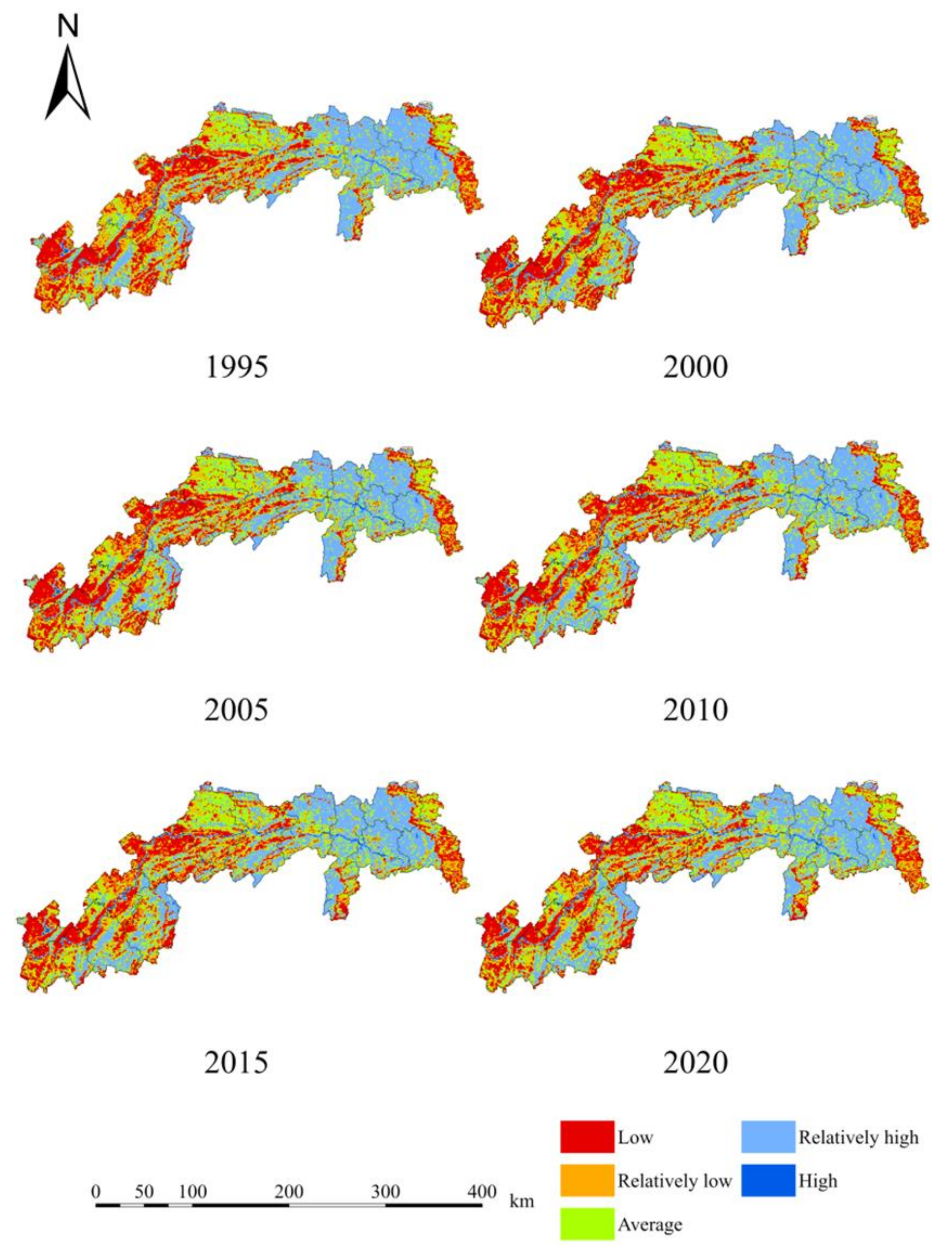
The research area in this study was small-scale towns, and a fine-scale unit of 1 km × 1 km was chosen for the spatial analysis of ecosystem service values. To classify the ESV into five levels for different time periods, the natural breakpoints method in GIS classification was used as the following: low (0–1.4 × CNY 106), relatively low (1.4 × 10⁶ − 2.3 × CNY 106), average (2.3 × 10⁶ − 3.2 × CNY 106), relatively high (3.2 × 10⁶ − 5.1 × CNY 106), and high (above 5.1 × CNY 106). The spatial distribution maps of the per unit area ESV for the six time periods in the study area were generated using spatial analysis and visualization using GIS (Figure 3).
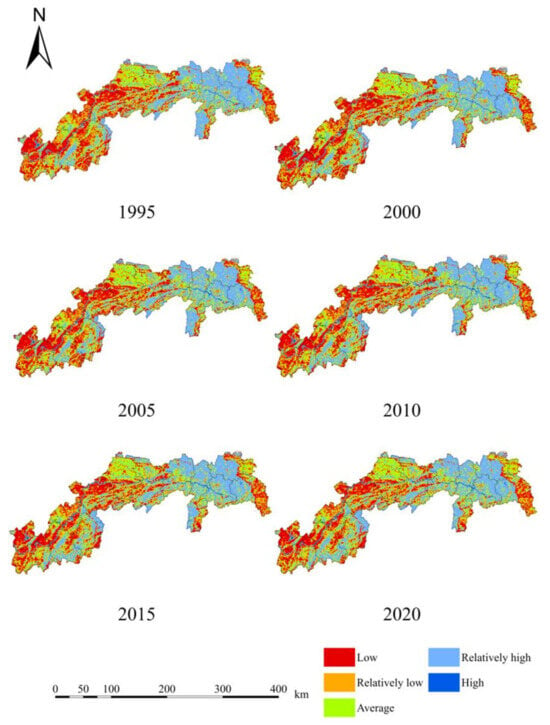
Figure 3.
Spatial Distribution of ESV in the TGRA from 1995 to 2020.
The graph shows that the unit area ESV is primarily classified into three situations: high, moderate, and low. Higher ESV values are predominantly located in the western half of Yiling in the TGRA’s northern sector, Zigui, Badong, Xingshan, and the far bank sections of Wushan and Fengjie in the Chongqing section. Furthermore, districts in Fuling and certain sections of Shizhu have higher ESV values. Furthermore, the geographical distribution of the ESV in this region has expanded during the last 25 years. The main cause for this is the presence of wooded terrain in this location, which has a greater ESV per unit area. This tendency can also be ascribed to the effective execution of long-term ecological conservation and afforestation initiatives. Within the region, areas with intermediate ESV levels have a dispersed distribution pattern. They only exhibit a scaled distribution pattern in a few localities, especially Yunyang in the short Chongqing segment and certain sections of Yiling District in the Hubei segment. Lower ESV values are concentrated in the reservoir’s Wanzhou, Zhong, Fuling, and tail segments in the Chongqing section. Cropland is the major land use type in the Chongqing section, resulting in somewhat lower unit area ecosystem service values. Since Yiling was absorbed into Yichang’s major urban area, the region has experienced fast urban growth and industry, resulting in significantly lower ESV values. In terms of geographical distribution, locations with a low ESV have shown a tendency to migrate to moderate and higher levels during the last 25 years. According to the analysis, the post-Three Gorges stage, as well as the execution of the Yangtze River Conservation and Yangtze River Economic Belt plans, has played a positive role in boosting environmental preservation and ecological restoration in the research region.
4.2.2. ESV Gain/Loss Analysis
Table 8 shows the gains and losses of ESV during a 25-year period based on the land use transfer matrix in the TGRA from 1995 to 2020. The majority of farmland was converted into forest, leading to an ESV loss of CNY 1.823 billion. A total of CNY 920 million was lost because some farmlands were transformed into a water area. The change in grassland to forest led to an ESV loss of CNY 2.825 billion. The increase in ESV was primarily due to the conversion of forest to farmland, which resulted in a CNY 1.979 billion gain. It can be seen that the post-Three Gorges stage, Yangtze River conservation, and Yangtze River Economic Belt strategy have strengthened ecological environment protection and measures to return farmland to the forest in the study area, yielding positive results. However, due to the resettlement of people affected by the Three Gorges Project, as well as the needs of the urban economy and population development, a substantial section of forest, which has a relatively big area, has been transformed into farmland and construction land. The primary driver of ESV loss in the study area is therefore the substitution of higher-value forestland with farmland and construction land. As a result, future building and development should place a great emphasis on encouraging high-quality urban development and prioritizing both ecological environment protection and “forest–grassland–water area” conservation awareness.

Table 8.
ESV Loss and Gain in the TGRA from 1995 to 2020 (×108 CNY).
4.3. Analysis of HAI
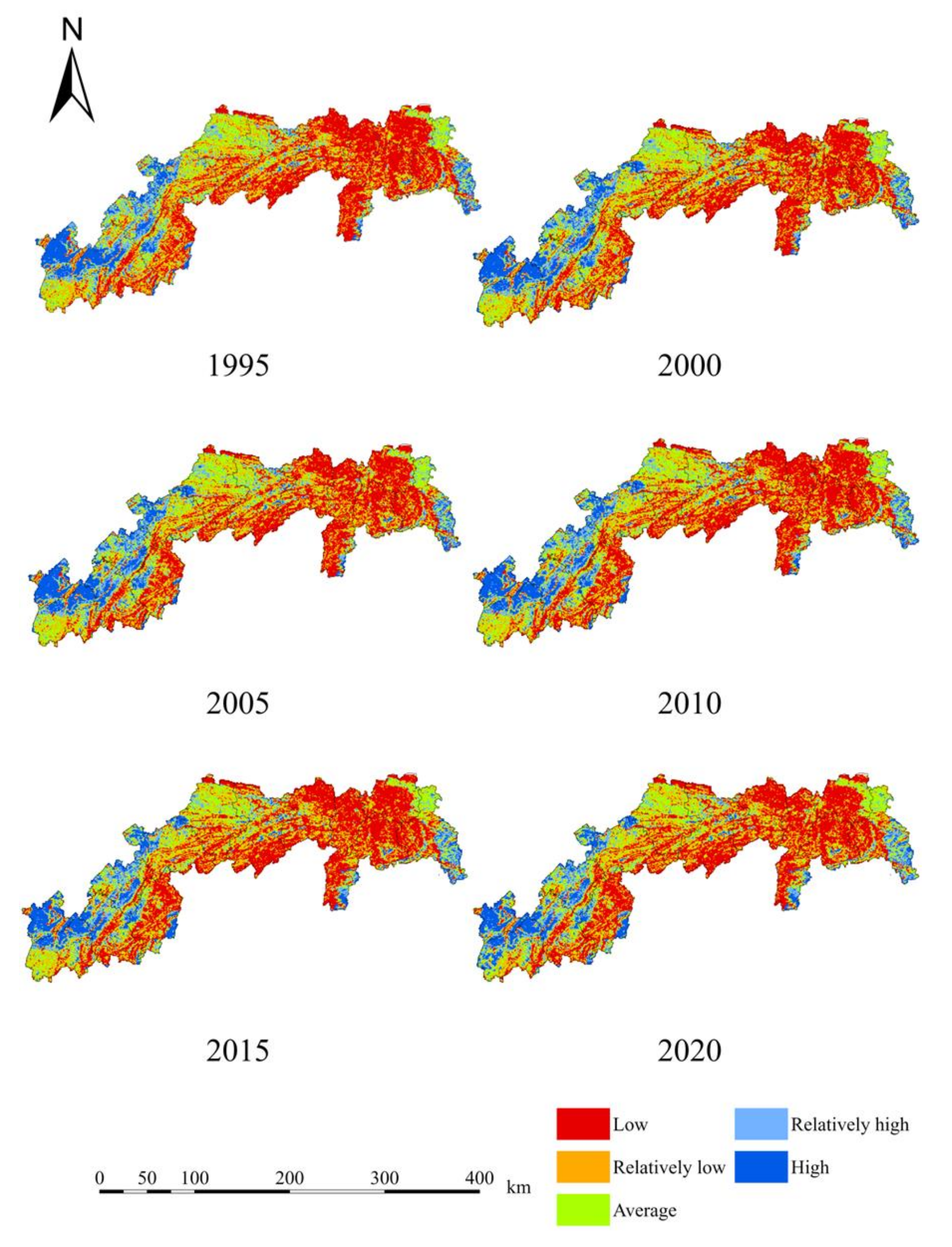
Figure 4 depicts the spatiotemporal fluctuations of the HAI in the TGRA from 1995 to 2020. Based on natural classification scales, activity intensity was divided into five categories: low, relatively low, average, relatively high, and high (Table 9). Throughout the research period, the spatial distribution of the HAI in the TGRA counties along the Yangtze River showed distinct trends between the Hubei and Chongqing parts. The spatial distribution of the HAI, notably in the relatively high and high categories, exhibited a more active trend in the Chongqing area and a relatively slower trend in the Hubei section over the 25-year period. The spatial distribution analysis suggests that the HAI is much greater in the Chongqing part than in the Hubei region. Within the Hubei sector, the HAI decreased from west to east, with high-intensity areas primarily centered in Yiling of Yichang and areas of moderate intensity scattered in Yiling and certain sections of Xingshan. The radiation-driven effect of social and economic development in Yichang has had the biggest impact on the spatial distribution of the HAI. The HAI decreased from west to east in the Chongqing region, with greater intensity seen on the northern bank compared to the southern bank. High-intensity locations include Changshou and Fuling, as well as the northern and southern areas near the Yangtze River in Fuling, Fengdu, and Zhong County, which are located close to Wanzhou and its surrounding areas. Areas of moderate intensity are found in Fuling’s eastern and southern regions, as well as in Yunyang. The radiation-driven effect of Chongqing’s social and economic development pattern, known as “one circle, two wings”, influences the spatial distribution of HAI in this region. This pattern contains Chongqing’s primary urban commuting circle, a northeastern wing centered on Wanzhou and a southeastern wing centered on Qianjiang. Chongqing, one of China’s four main municipalities has witnessed fast social and economic development, resulting in an increase in the HAI within its jurisdiction as a consequence of urban construction, industrialization, and economic development. The combined study of Figure 3 and Figure 4 indicates a robust regional link between the HAI and ESV.
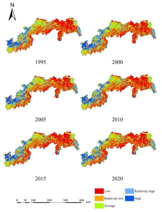
Figure 4.
Spatial Distribution Map of the HAI per Unit Area in the TGRA.

Table 9.
Structural Table of HAI Levels in the TGRA from 1995 to 2020.
4.4. Correlation Analysis of the ESV and HAI
4.4.1. Bivariate Spatial Correlation Analysis
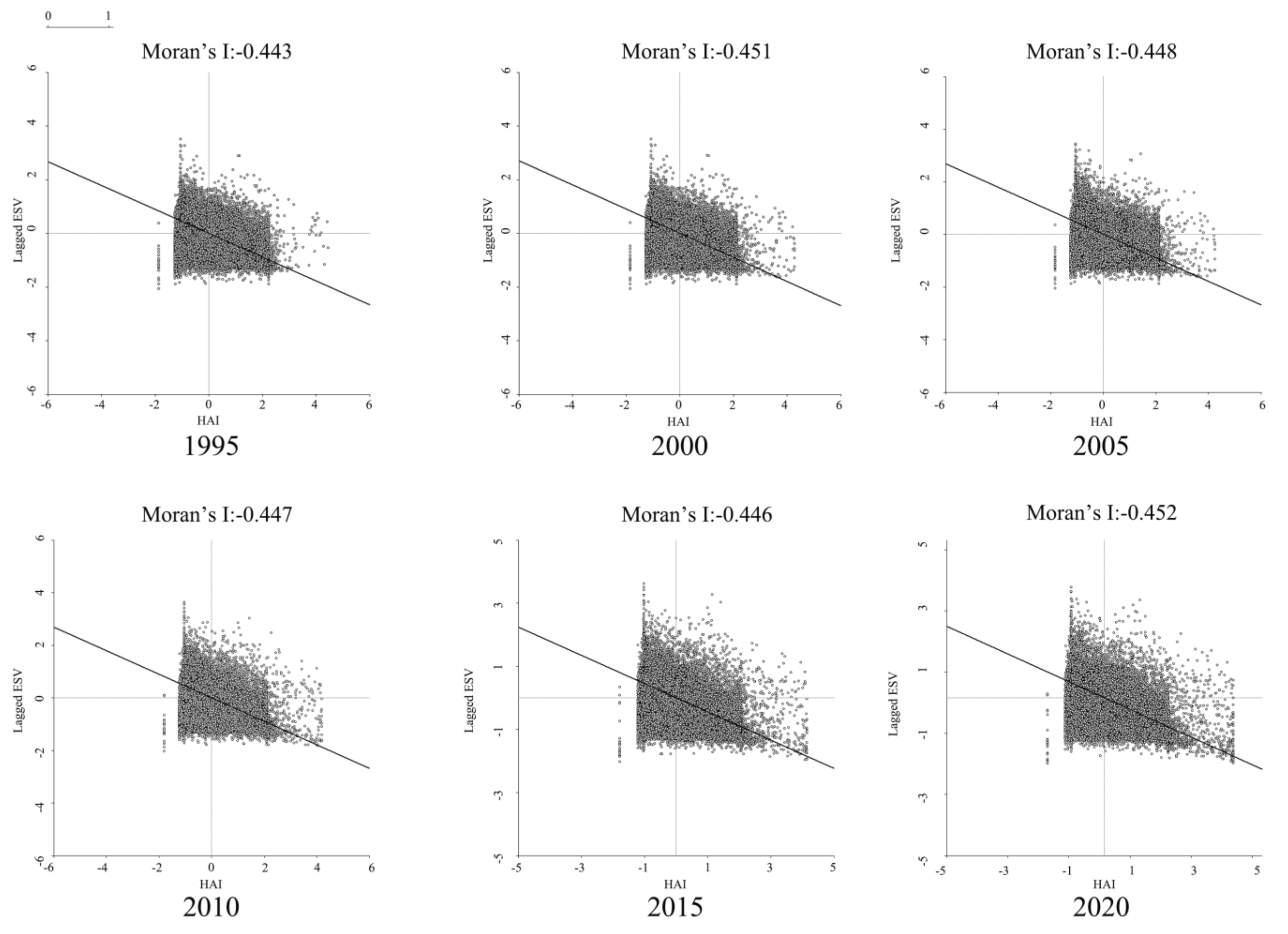
Figure 5 depicts the findings of a bivariate spatial autocorrelation model and scatter plot analysis of the unit grid’s per unit area ecosystem service value and HAI over six time periods. The indices of correlation between the two variables were computed. For 1995, 2000, 2005, 2010, 2015, and 2020, the bivariate spatial autocorrelation indices were −0.443, −0.451, −0.448, −0.447, −0.446, and −0.452, respectively. These indices show that the two variables had a reasonably substantial negative spatial association. Throughout the research period, the negative spatial relationship among them increased at first, then reduced, and then increased again.
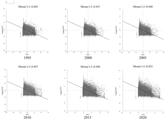
Figure 5.
Scatterplot of ESV and HAI in the TGRA based on Moran’s Index.
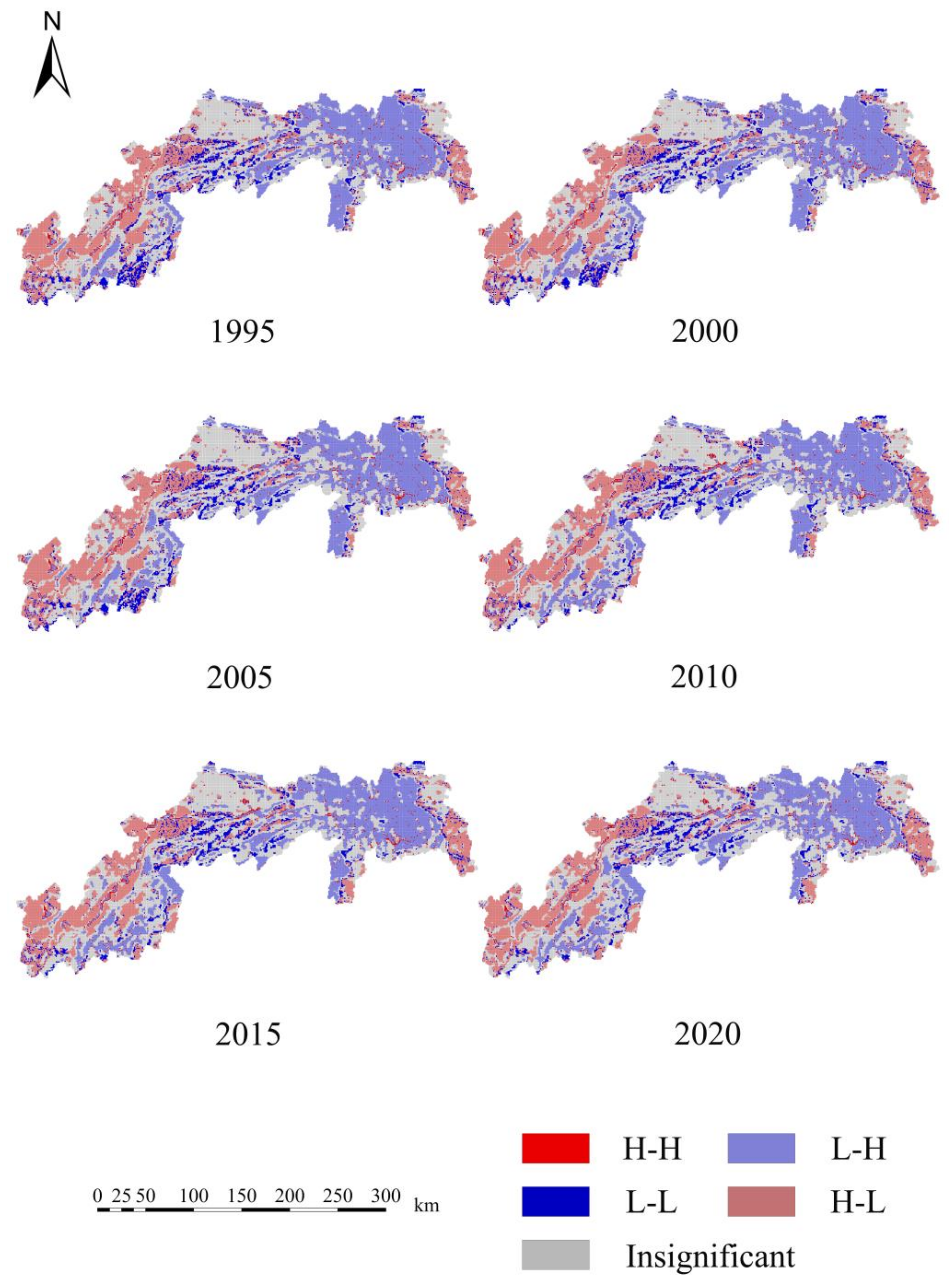
Figure 6 indicates the LISA cluster maps of the HAI and ESV based on bivariate spatial autocorrelation analysis using GeoDa 1.20.36 software. Low HAI–high ESV (L–H) clusters dominate the spatial clustering patterns of the ESV and HAI in the TGRA. High HAI–high ESV (H–H) clusters are mostly scattered, while low HAI–low ESV(L–L) clusters are sporadically distributed in the reservoir’s Chongqing part. In terms of spatial distribution, low activity–high service value clusters dominate the Hubei section of the research region, while high HAI–low ESV(H–L) clusters dominate the eastern and southern parts of the Hubei section. The northern bank of the Yangtze River in the Chongqing sector of the reservoir region is dominated by high HAI–low ESV clusters, and the southern bank is dominated by low HAI–high ESV clusters. In terms of temporal patterns, the Chongqing section’s random distribution of low HAI–low ESV clusters has decreased with time, resulting in the establishment of low HAI–high ESV cluster zones. This can be linked to the implementation and rising effectiveness of environmental protection and restoration initiatives such as the post-Three Gorges stage, Yangtze River protection, and Yangtze River Economic Belt policies.
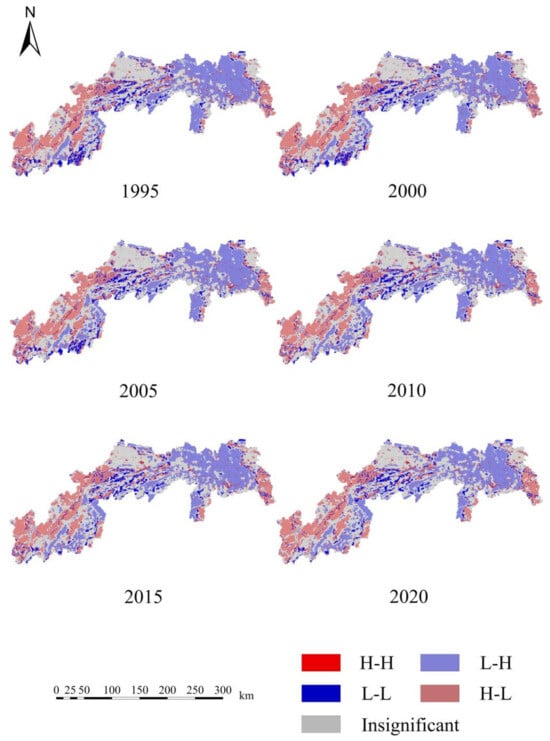
Figure 6.
Spatial Correlation Distribution Map of the HAI and ESV in the TGRA.
4.4.2. Analysis of the Degree of Spatial and Temporal Influence of the HAI on the ESV
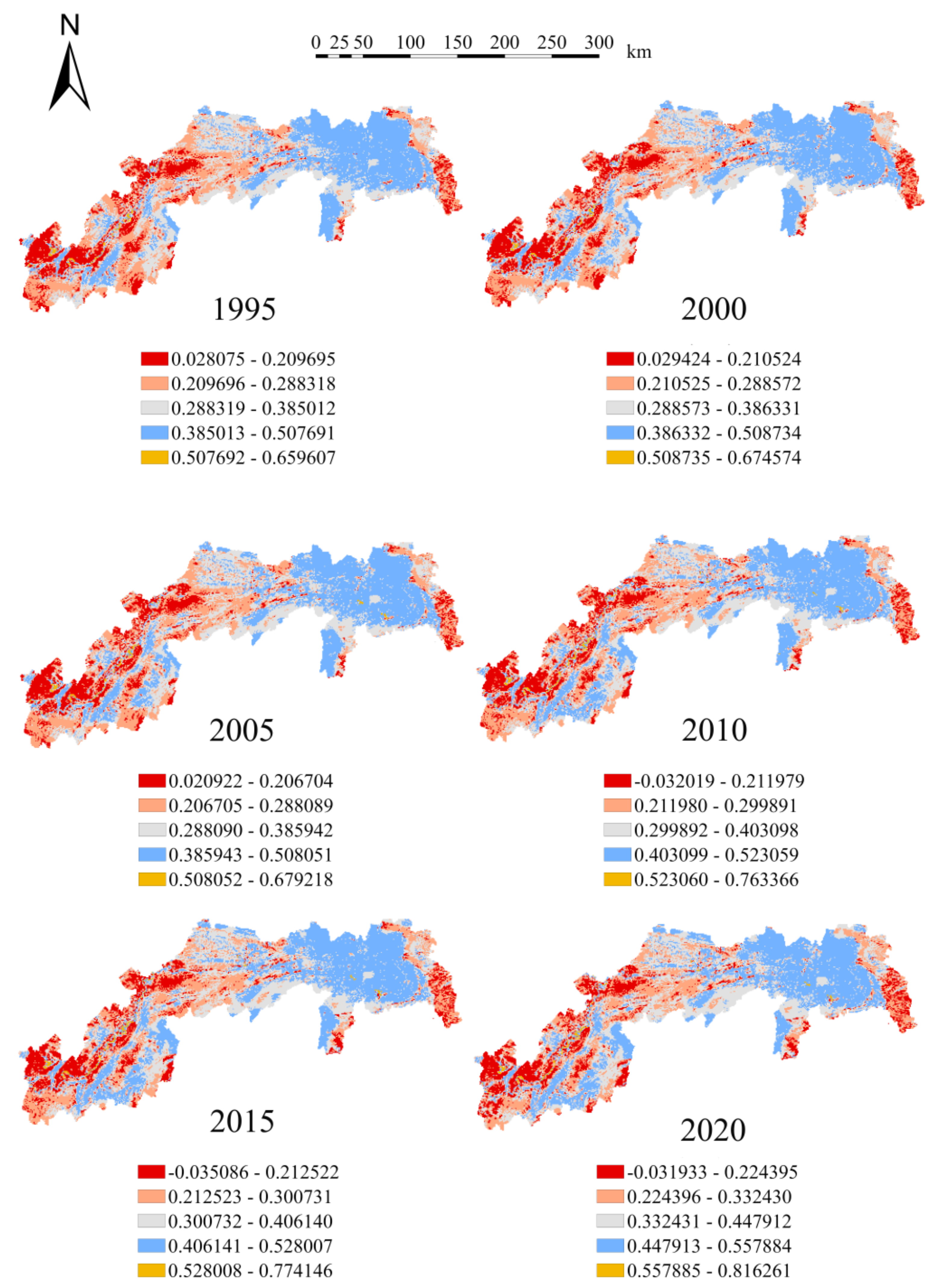
As can be seen in Figure 7, the GWR model was used to determine the influence of the HAI on the ESV in the TGRA. This was completed in order to shed light on the interaction mechanisms that exist between the ESV and HAI. The number of studies that find a negative connection between the HAI and ESV is expected to increase between the years 1995 and 2020. The negative association is most noticeable in the regions of Shizhu, Fengdu, Fengjie, and Wushan in the Chongqing sector, which is characterized by a dense distribution of land use types including forest, farmland, and grassland. These regions are located in Southwest China. The decrease in available land area that was created by the impoundment of the Three Gorges Project has had a substantial influence on human activities, which in turn has had an impact on the ESV. Higher regression coefficients were obtained in the southeastern portion of Badong and Yiling in the Hubei region, which shows that the overall negative association between the HAI and ESV is getting stronger as the section progresses. This suggests that urbanization has been steadily progressing over the several decades, resulting in a rise in the quantify of land available for building. The expansion of human urban activities has led to the transformation of certain agricultural land and forest into land suitable for construction, which has had an effect on the ESV as a whole.
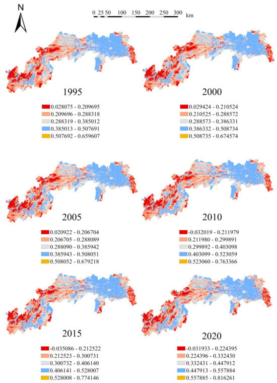
Figure 7.
The Spatial Heterogeneity Pattern of the HAI’s Impact on the ESV in the TGRA.
The overall spatial distribution reveals that the HAI has a rather broad overall spatial distribution on the ESV. Furthermore, the overall regression coefficient displays two high segments and one low segment across the board. The overall regression coefficient is shown to be greater in the Changshou, Fuling, and Zhongxian, which are located in the reservoir’s tail part. This is due to the fact that these places are located in close proximity to the primary metropolitan area of Chongqing and have flatter terrain, which makes them ideal for the growth of human urban activities and, as a consequence, greater HAI levels. The geographical distribution of regression coefficients in the central region of Zhong County exhibits a steady shift from a single core in 1995 to many scattered cores over the course of the intervening years. The effect that the HAI has had on the value of ecosystem services has been gradually decreasing. The middle region, which includes the cities of Fuling, Shizhu, Fengjie, and Wushan, has a lower prevalence of the HAI as a result of its higher elevation and predominant land types, which are cropland, woodland, and grassland. As a direct consequence of this, the impact of the HAI on the ESV is reduced in these areas. The region places a strong emphasis on ecological conservation and protection, which may be one of the reasons why ESV levels in the reservoir area have remained relatively stable in relation to the HAI.
5. Discussion
5.1. Causal Relationship between HAI–Land Use–ESV
Land serves as the medium and link between human activities and the natural ecosystem, with human socioeconomic activities being interconnected with the natural environment through land utilization. This study analyzed the changes in the HAI and land use patterns in the TGRA over a period of 20 years, revealing an overall increase in the HAI and a significant increase in construction land in the land use patterns. During the period from 1995 to 2005, there was a noticeable increase in high-impact areas of the HAI (HAI ≥ 0.8) Additionally, there was a substantial expansion of construction land in the land use patterns, while grassland and unused land decreased, and water area increased. Between 2005 and 2010, high-impact areas of the HAI decreased, and low-impact areas (HAI ≤ 0.2) increased. In terms of land use patterns, construction land nearly doubled, water area increased, and the areas of grassland and unused land decreased. Between 2010 and 2020, the high-impact areas of the HAI remained stable, ranging from 10.56% to 10.86%. In terms of land use patterns, construction land increased by nearly double, while the grassland and water area decreased. Over the past two decades, human activities in the Three Gorges Reservoir Area have primarily revolved around the construction of the Three Gorges Project, urbanization development, and industrial structural adjustments.
According to statistical yearbook data, the urbanization rate in the TGRA increased from 9.36% in 1995 to 51.68% in 2020, indicating a rapid expansion of urban construction land. The rising urbanization rate has also led to population growth. The increased demand for agricultural products, especially grains, has resulted in the encroachment on forests and grasslands to expand farmland and construction land. Additionally, human activities such as the construction of the Three Gorges Project and the impoundment of the TGRA have led to an increase in water area, a reduction in grasslands, and a decrease in unused land.
The changes in land use patterns directly impact the ESV. The main land use types in the study area are primarily farmland, forest, and grassland. In terms of regional distribution, farmland dominates in the Chongqing section, while forest prevails in the Hubei section. Regarding the total ESV, it increased from CNY 1017.16 × 108 in 1995 to CNY 1052.73 × 108 in 2020, with a growth rate of 3.51%. Compared to related studies in the same region, this value estimation is generally consistent. The ESV of various land types, ranked from high to low, are the following: forest, farmland, water area, grassland, unused land, and construction land. Due to changes in land use patterns, the conversion between forests, farmland, grassland, and construction land has resulted in varying shifts in ESV. During the period of reservoir construction from 1995 to 2000, rapid urbanization led to an increased demand for construction land, causing a decline in ESV. This is attributed to policies such as reforestation initiatives and active promotion of green transformation, which have contributed to an enhancement of the ESV in the TGRA.
5.2. Driving Factors of ESV Changes
Construction of the Three Gorges Project took place from 1995 to 2000. The construction activities occupied previously used ecological lands such as farmland, forests, and grasslands. This led to an increase in construction land due to the production facilities and residential areas required for supporting infrastructure. The combination of these factors resulted in a reduction in the regional ESV. From 2000 to 2005, the Three Gorges Project completed its initial impoundment in 2003, leading to an increase in water area. Additionally, the “grain for green” policy led to an increase in forestland area. As a result, the ESV showed growth during this period. From 2005 to 2010, the Three Gorges Project continued to raise the impoundment level to 175 m, further increasing the water area and consequently boosting the ESV in the study area. From 2010 to 2020, the TGRA was designated as a nationally important ecological functional area. Particularly, after 2016, with the advancement of the Yangtze River protection and the high-quality development strategy for the Yangtze River Economic Belt, strict controls were imposed on ecological protection redlines and urban development boundaries. This effectively managed the expansion of construction land. Simultaneously, the deepening implementation of the “grain for green” policy led to an increase in ecological land, including forested areas, resulting in an overall increase in the ESV during this period. Through the comparison of the relevant studies of Zhao [59], the overall ESV value of Chongqing is less than that of Zhao because the main urban area is not included in the research scope. However, the overall spatiotemporal variation trend of ESV is consistent with other studies.
5.3. Limitations and Improvements
In previous studies, most of them have employed large-scale grid units (2 km × 2 km) to calculate and analyze the numerical evolution characteristics of land use and the ESV. In contrast, this study, recognizing the small urban scale and significant small-scale variations in ecological environments within the TGRA, employed a finer grained grid division of 1 km × 1 km grid cells, yielding more precise results. Additionally, to enhance the accuracy of ESV estimation, we incorporated modifications to the ESV model based on regional variations, utilizing NPP data. We also employed an MGWR to assess and predict the impact of the HAI on ESV in the TGRA. This study aimed to explore the mechanisms through which the HAI affected the ESV from the perspectives of policy, society, and technology.
In the assessment of ecosystem service values, the equivalent factor method is more intuitive and requires less data. Therefore, this study employed the equivalent factor method to assess the ESV in the TGRA. However, due to variations in the correction methods, parameter selection, and the method’s reliance on equivalent factor values, there can be differences in the calculated ESV results. Additionally, the resolution of land use data can affect the accuracy of ESV assessments. Future research should be conducted on a foundation of more precise ESV assessment methods and finer resolution data, through the use of higher resolution land use remote sensing data and fine models of various ecological services. This could include the use of the USLE equation for soil conservation through which intermediate material conversion is performed for the regulation of service precipitation to obtain more accurate results.
6. Conclusions
The HAI has a significant impact on land use pattern changes. A series of human activities have collectively driven changes in the land use patterns within the TGRA. The land use patterns in the TGRA can be characterized as follows in descending order of land use types: forest > farmland > grassland > water area > construction land > unused land. With changes in the HAI, the land use patterns exhibited characteristics such as the conversion of farmland into construction land and water area, the conversion of forest into farmland and water area, and the conversion of grassland into forest and farmland.
The phase changes in the HAI in the TGRA have led to alterations in the regional land use patterns, subsequently affecting the regional ESV. During the construction of the Three Gorges Project, the original houses, farmland, and villages in the TGRA were submerged, and farmland, forest, and grassland were converted into construction land to relocate the residents. As a result, during this phase, the ESV showed a declining trend. In the post-Three Gorges era, the TGRA, as an important ecological functional zone in the Yangtze River basin, has witnessed a reduction in high-impact areas of the HAI and an increase in low-impact areas. Additionally, efforts were made to strengthen ecological environmental protection and restoration. The “grain for green” project was further promoted, and there was a noticeable trend of grassland and farmland being converted into forest. In addition, with the increase in water area, the regional ESV showed a growing trend. During the implementation of the Yangtze River Economic Belt strategy, guided by the principles of sustainable development, the high-impact areas of the HAI were effectively constrained. These zones were primarily concentrated in areas with well-developed urban construction, such as the surrounding areas of Chongqing’s main urban area, Wanzhou, and Yiling District. In contrast, the low-impact areas have shown a gradual increase, leading to an overall increase in the ESV in the TGRA.
The urbanization process in the TGRA along with human activities such as regional socioeconomic development have caused significant disruptions to the regional land use patterns, ultimately leading to a decrease in the ESV. The intensified human activity has resulted in a reduction in the ESV. The TGRA, as an important ecological functional zone, plays a vital role in the Yangtze River basin. It is a crucial component of the Yangtze River Economic Belt and a key hub within the Yangtze River and Chengdu-Chongqing urban agglomerations. The study of strategies to improve regional ecological security and ecological resilience is of great significance to further promoting the high-quality development strategy of the Yangtze River Economic Belt.
Author Contributions
Conceptualization, G.L. and Z.W.; methodology, Z.W., G.C. and G.L.; software, Z.W. and Y.Y.; investigation, Z.W. and G.C.; data curation, Z.W. and Y.Y.; writing—original draft preparation, Z.W., G.C. and Y.Y.; writing—review and editing, G.L.; visualization, Z.W.; supervision, G.L. and Y.H.; funding acquisition, G.L. and H.W. All authors have read and agreed to the published version of the manuscript.
Funding
This research was funded by the National Natural Science Foundation of China’s “Research on Multidimensional Coupling Enhancement of the Resilience of the “City–Rural” Space Complex Giant System in the Three Gorges Reservoir Area” project (52078193), the Doctoral Fund of Hubei University of Technology for the project “Study on the vulnerability multi-dimensional coupling coercion of the complex system of “city–town” space in the Three Gorges Reservoir Area” (BSQD2020047), the National Natural Science Foundation of China’s “Research on the formation mechanism and development evolution of Nanjing modern educational architecture from the perspective of pedagogy (1840–1949)” project (52008157), and the International Science and Technology Cooperation Project of Hubei Province: “The research on multi-scenario simulation and early warning system for urban disaster resilience: A case study of Wuhan.” (GJHZ2023000054).
Institutional Review Board Statement
Not applicable.
Informed Consent Statement
Not applicable.
Data Availability Statement
The case analysis data used to support the findings of this study are available from the corresponding author upon request.
Acknowledgments
The authors would like to extend special thanks to the municipal and county-level government departments in the Hubei and Chongqing Sections of the Three Gorges Reservoir Area for providing statistical data.
Conflicts of Interest
The authors declare no conflict of interest.
References
- Cendrero, A.; Forte, L.M.; Remondo, J.; Cuesta-Albertos, J.A. Anthropocene Geomorphic Change. Climate or Human Activities? Earth’s Future 2020, 8, e2019EF001305. [Google Scholar] [CrossRef]
- Reed, P.M.; Hadjimichael, A.; Moss, R.H.; Brelsford, C.; Burleyson, C.D.; Cohen, S.; Dyreson, A.; Gold, D.F.; Gupta, R.S.; Keller, K.; et al. Multisector Dynamics: Advancing the Science of Complex Adaptive Human-Earth Systems. Earth’s Future 2022, 10, e2021EF002621. [Google Scholar] [CrossRef]
- Shi, P.; Fang, W.; Liu, J.; Zhou, M.; He, F.; Pu, Q.; Du, J.; Zheng, J. Research on Earth-Surface Interaction Mechanism, Process and Dynamics of Human-Earth System: Case Study on the Geographic Belt Transect from Shenzhen in Guangdong Province to Bayanhaote in Inner Mongolia Province of China. Geogr. Inf. Sci. 2008, 14, 1–11. [Google Scholar] [CrossRef]
- Perry, C.T.; Alvarez-Filip, L. Changing Geo-Ecological Functions of Coral Reefs in the Anthropocene. Funct. Ecol. 2019, 33, 976–988. [Google Scholar] [CrossRef]
- Lazarina, M.; Devalez, J.; Neokosmidis, L.; Sgardelis, S.P.; Kallimanis, A.S.; Tscheulin, T.; Tsalkatis, P.; Kourtidou, M.; Mizerakis, V.; Nakas, G.; et al. Moderate Fire Severity Is Best for the Diversity of Most of the Pollinator Guilds in Mediterranean Pine Forests. Ecology 2019, 100, e02615. [Google Scholar] [CrossRef] [PubMed]
- Cinner, J.E.; Barnes, M.L. Social Dimensions of Resilience in Social-Ecological Systems. One Earth 2019, 1, 51–56. [Google Scholar] [CrossRef]
- Han, Z.; Cui, S.; Yan, X.; Liu, C.; Li, X.; Zhong, J.; Wang, X. Guiding Sustainable Urban Development via a Multi-Level Ecological Framework Integrating Natural and Social Indicators. Ecol. Indic. 2022, 141, 109142. [Google Scholar] [CrossRef]
- Moreno-Llorca, R.; Vaz, A.S.; Herrero, J.; Millares, A.; Bonet-García, F.J.; Alcaraz-Segura, D. Multi-Scale Evolution of Ecosystem Services’ Supply in Sierra Nevada (Spain): An Assessment over the Last Half-Century. Ecosyst. Serv. 2020, 46, 101204. [Google Scholar] [CrossRef]
- Xue, C.; Zhang, H.; Wu, S.; Chen, J.; Chen, X. Spatial-Temporal Evolution of Ecosystem Services and Its Potential Drivers: A Geospatial Perspective from Bairin Left Banner, China. Ecol. Indic. 2022, 137, 108760. [Google Scholar] [CrossRef]
- Nematollahi, S.; Fakheran, S.; Kienast, F.; Jafari, A. Application of InVEST Habitat Quality Module in Spatially Vulnerability Assessment of Natural Habitats (Case Study: Chaharmahal and Bakhtiari Province, Iran). Environ. Monit. Assess. 2020, 192, 487. [Google Scholar] [CrossRef]
- Veldhuis, M.P.; Ritchie, M.E.; Ogutu, J.O.; Morrison, T.A.; Beale, C.M.; Estes, A.B.; Mwakilema, W.; Ojwang, G.O.; Parr, C.L.; Probert, J.; et al. Cross-Boundary Human Impacts Compromise the Serengeti-Mara Ecosystem. Science 2019, 363, 1424–1428. [Google Scholar] [CrossRef] [PubMed]
- Adeyeri, O.E.; Laux, P.; Ishola, K.A.; Zhou, W.; Balogun, I.A.; Adeyewa, Z.D.; Kunstmann, H. Homogenising Meteorological Variables: Impact on Trends and Associated Climate Indices. J. Hydrol. 2022, 607, 127585. [Google Scholar] [CrossRef]
- Murali, G.; de Oliveira Caetano, G.H.; Barki, G.; Meiri, S.; Roll, U. Emphasizing Declining Populations in the Living Planet Report. Nature 2022, 601, E20–E24. [Google Scholar] [CrossRef] [PubMed]
- Corbau, C.; Zambello, E.; Rodella, I.; Utizi, K.; Nardin, W.; Simeoni, U. Quantifying the Impacts of the Human Activities on the Evolution of Po Delta Territory during the Last 120 Years. J. Environ. Manag. 2019, 232, 702–712. [Google Scholar] [CrossRef] [PubMed]
- Cao, M.; Zhu, Y.; Quan, J.; Zhou, S.; Lü, G.; Chen, M.; Huang, M. Spatial Sequential Modeling and Predication of Global Land Use and Land Cover Changes by Integrating a Global Change Assessment Model and Cellular Automata. Earth’s Future 2019, 7, 1102–1116. [Google Scholar] [CrossRef]
- Zalles, V.; Hansen, M.C.; Potapov, P.V.; Parker, D.; Stehman, S.V.; Pickens, A.H.; Parente, L.L.; Ferreira, L.G.; Song, X.-P.; Hernandez-Serna, A.; et al. Rapid Expansion of Human Impact on Natural Land in South America since 1985. Sci. Adv. 2021, 7, eabg1620. [Google Scholar] [CrossRef] [PubMed]
- Zhang, X.; Wang, X.; Zhou, Z.; Li, M.; Jing, C. Spatial Quantitative Model of Human Activity Disturbance Intensity and Land Use Intensity Based on GF-6 Image, Empirical Study in Southwest Mountainous County, China. Remote Sens. 2022, 14, 4574. [Google Scholar] [CrossRef]
- Huang, A.; Xu, Y.; Sun, P.; Zhou, G.; Liu, C.; Lu, L.; Xiang, Y.; Wang, H. Land Use/Land Cover Changes and Its Impact on Ecosystem Services in Ecologically Fragile Zone: A Case Study of Zhangjiakou City, Hebei Province, China. Ecol. Indic. 2019, 104, 604–614. [Google Scholar] [CrossRef]
- Wei, H.; Xiong, L.; Tang, G.; Strobl, J.; Xue, K. Spatial–Temporal Variation of Land Use and Land Cover Change in the Glacial Affected Area of the Tianshan Mountains. CATENA 2021, 202, 105256. [Google Scholar] [CrossRef]
- Xie, J.; Lu, Z.; Feng, K. Effects of Climate Change and Human Activities on Aeolian Desertification Reversal in Mu Us Sandy Land, China. Sustainability 2022, 14, 1669. [Google Scholar] [CrossRef]
- Cafaro, P.; Hansson, P.; Götmark, F. Conserving Biodiversity Means Limiting Our Numbers: A Response to Green et al. 2022. Biol. Conserv. 2022, 273, 109701. [Google Scholar] [CrossRef]
- Nunes, C.A.; Berenguer, E.; França, F.; Ferreira, J.; Lees, A.C.; Louzada, J.; Sayer, E.J.; Solar, R.; Smith, C.C.; Aragão, L.E.O.C.; et al. Linking Land-Use and Land-Cover Transitions to Their Ecological Impact in the Amazon. Proc. Natl. Acad. Sci. USA 2022, 119, e2202310119. [Google Scholar] [CrossRef] [PubMed]
- Liu, Y.; Cao, S.; Li, X.; Li, F.; Zhang, X. Combined Effect of Climate Change and Human Activities on the Hydrological Processes of an Urban River: Case Study of the Xiaoqing River, China. Hydrol. Sci. J. 2019, 64, 2105–2114. [Google Scholar] [CrossRef]
- Wang, Y.; Gu, X.; Yang, G.; Yao, J.; Liao, N. Impacts of Climate Change and Human Activities on Water Resources in the Ebinur Lake Basin, Northwest China. J. Arid Land 2021, 13, 581–598. [Google Scholar] [CrossRef]
- Li, Y.; Fang, L.; Yuanzhu, W.; Mi, W.; Ji, L.; Guixiang, Z.; Yang, P.; Chen, Z.; Bi, Y. Anthropogenic Activities Accelerated the Evolution of River Trophic Status. Ecol. Indic. 2022, 136, 108584. [Google Scholar] [CrossRef]
- Gries, T.; Redlin, M.; Ugarte, J.E. Human-Induced Climate Change: The Impact of Land-Use Change. Theor. Appl. Climatol. 2019, 135, 1031–1044. [Google Scholar] [CrossRef]
- Zhao, Y.; Feng, Q.; Lu, A. Spatiotemporal Variation in Vegetation Coverage and Its Driving Factors in the Guanzhong Basin, NW China. Ecol. Inform. 2021, 64, 101371. [Google Scholar] [CrossRef]
- Dariane, A.B.; Pouryafar, E. Quantifying and Projection of the Relative Impacts of Climate Change and Direct Human Activities on Streamflow Fluctuations. Clim. Change 2021, 165, 34. [Google Scholar] [CrossRef]
- Su, S.; Wang, Y.; Luo, F.; Mai, G.; Pu, J. Peri-Urban Vegetated Landscape Pattern Changes in Relation to Socioeconomic Development. Ecol. Indic. 2014, 46, 477–486. [Google Scholar] [CrossRef]
- Huang, M.; Li, Y.; Xia, C.; Zeng, C.; Zhang, B. Coupling Responses of Landscape Pattern to Human Activity and Their Drivers in the Hinterland of Three Gorges Reservoir Area. Glob. Ecol. Conserv. 2022, 33, e01992. [Google Scholar] [CrossRef]
- Liu, X.; Zhang, Z.; Li, M.; Fu, Y.; Hui, Y. Spatial Conflict Simulation of Land-Use Based on Human-Land-Landscape Elements Intercoordination: A Case Study in Tianjin, China. Environ. Monit. Assess. 2022, 194, 317. [Google Scholar] [CrossRef] [PubMed]
- Zolfagharpour, F.; Saghafian, B.; Delavar, M. Hydrological Alteration and Biodiversity Change along the River Network Caused by Anthropogenic Activities and Climate Variability. Ecol. Process. 2022, 11, 19. [Google Scholar] [CrossRef]
- Carreño, L.; Frank, F.C.; Viglizzo, E.F. Tradeoffs between Economic and Ecosystem Services in Argentina during 50 Years of Land-Use Change. Agric. Ecosyst. Environ. 2012, 154, 68–77. [Google Scholar] [CrossRef]
- Li, Y.; Liu, W.; Feng, Q.; Zhu, M.; Yang, L.; Zhang, J. Quantitative Assessment for the Spatiotemporal Changes of Ecosystem Services, Tradeoff–Synergy Relationships and Drivers in the Semi-Arid Regions of China. Remote Sens. 2022, 14, 239. [Google Scholar] [CrossRef]
- Liu, Y.; Li, Y.; Li, S.; Motesharrei, S. Spatial and Temporal Patterns of Global NDVI Trends: Correlations with Climate and Human Factors. Remote Sens. 2015, 7, 13233–13250. [Google Scholar] [CrossRef]
- Jahelnabi, A.E.; Zhao, J.; Li, C.; Fadoul, S.M.; Shi, Y.; Bsheer, A.K.; Yagoub, Y.E. Assessment of the Contribution of Climate Change and Human Activities to Desertification in Northern Kordofan-Province, Sudan Using Net Primary Productivity as an Indicator. Contemp. Probl. Ecol. 2016, 9, 674–683. [Google Scholar] [CrossRef]
- Gaodi, X.; Shuyan, C.; Chunxia, L.; Changshun, Z.; Yu, X. Current Status and Future Trends for Eco-Compensation in China. J. Resour. Ecol. 2015, 6, 355–362. [Google Scholar] [CrossRef]
- Rabby, Y.W.; Li, Y.; Abedin, J.; Sabrina, S. Impact of Land Use/Land Cover Change on Landslide Susceptibility in Rangamati Municipality of Rangamati District, Bangladesh. ISPRS Int. J. Geo Inf. 2022, 11, 89. [Google Scholar] [CrossRef]
- Zhang, F.; Zeng, B.; Yang, T.; Zheng, Y.; Cao, Y. A Multi-Perspective Assessment Method with a Dynamic Benchmark for Human Activity Impacts on Alpine Ecosystem under Climate Change. Remote Sens. 2022, 14, 208. [Google Scholar] [CrossRef]
- Mu, H.; Li, X.; Wen, Y.; Huang, J.; Du, P.; Su, W.; Miao, S.; Geng, M. A Global Record of Annual Terrestrial Human Footprint Dataset from 2000 to 2018. Sci. Data 2022, 9, 176. [Google Scholar] [CrossRef]
- Ruiz-Sandoval, D.; Arana-Coronado, J.J.; Godbout, S.; Sandoval-Salas, F.; Brambila-Paz, J.J.; Ruiz-Sandoval, D.; Arana-Coronado, J.J.; Godbout, S.; Sandoval-Salas, F.; Brambila-Paz, J.J. Economic Valuation of Three Ecosystem Services before the Establishment of a Greenbelt of Quebec City Forest, Canada. Rev. Chapingo Ser. Cienc. For. Ambiente 2019, 25, 3–15. [Google Scholar] [CrossRef]
- Zhao, X.; He, Y.; Yu, C.; Xu, D.; Zou, W. Assessment of Ecosystem Services Value in a National Park Pilot. Sustainability 2019, 11, 6609. [Google Scholar] [CrossRef]
- Tilahun, M.; Damnyag, L.; Anglaaere, L.C.N. The Ankasa Forest Conservation Area of Ghana: Ecosystem Service Values and on-Site REDD+ Opportunity Cost. For. Policy Econ. 2016, 73, 168–176. [Google Scholar] [CrossRef]
- Tang, S.; Wang, L.; Wu, X.; Xu, Z.; Chen, L. Dynamic Evaluation and Spatial Mapping of Wetland Ecosystem Services Value—A Case Study on Nanjing Jiangbei New Area. Environ. Eng. Manag. J. 2019, 18, 2519–2532. [Google Scholar]
- Logsdon, R.A.; Chaubey, I. A Quantitative Approach to Evaluating Ecosystem Services. Ecol. Model. 2013, 257, 57–65. [Google Scholar] [CrossRef]
- Li, G.; Cheng, G.; Wu, Z.; Liu, X. Coupling Coordination Research on Disaster-Adapted Resilience of Modern Infrastructure System in the Middle and Lower Section of the Three Gorges Reservoir Area. Sustainability 2022, 14, 14514. [Google Scholar] [CrossRef]
- Li, G.; Cheng, G.; Wu, Z. Resilience Assessment of Urban Complex Giant Systems in Hubei Section of the Three Gorges Res ervoir Area Based on Multi-Source Data. Sustainability 2022, 14, 8423. [Google Scholar] [CrossRef]
- Gaodi, X.; Lin, Z.; Chunxia, L.; Yu, X.; Wenhua, L. Applying Value Transfer Method for Eco-Service Valuation in China. J. Resour. Ecol. 2010, 1, 51–59. [Google Scholar] [CrossRef]
- Costanza, R.; d’Arge, R.; de Groot, R.; Farber, S.; Grasso, M.; Hannon, B.; Limburg, K.; Naeem, S.; O’Neill, R.V.; Paruelo, J.; et al. The Value of the World’s Ecosystem Services and Natural Capital. Nature 1997, 387, 253–260. [Google Scholar] [CrossRef]
- Xie, G.; Zhang, C.; Zhen, L.; Zhang, L. Dynamic Changes in the Value of China’s Ecosystem Services. Ecosyst. Serv. 2017, 26, 146–154. [Google Scholar] [CrossRef]
- Liu, Z.; Wu, R.; Chen, Y.; Fang, C.; Wang, S. Factors of Ecosystem Service Values in a Fast-Developing Region in China: Insights from the Joint Impacts of Human Activities and Natural Conditions. J. Clean. Prod. 2021, 297, 126588. [Google Scholar] [CrossRef]
- Guo, S.; Wu, C.; Wang, Y.; Qiu, G.; Zhu, D.; Niu, Q.; Qin, L. Threshold Effect of Ecosystem Services in Response to Climate Change, Human Activity and Landscape Pattern in the Upper and Middle Yellow River of China. Ecol. Indic. 2022, 136, 108603. [Google Scholar] [CrossRef]
- Zhang, Z.; Xia, F.; Yang, D.; Huo, J.; Wang, G.; Chen, H. Spatiotemporal Characteristics in Ecosystem Service Value and Its Interaction with Human Activities in Xinjiang, China. Ecol. Indic. 2020, 110, 105826. [Google Scholar] [CrossRef]
- Ranta, E.; Kaitala, V.; Lindström, J.; Helle, E. The Moran Effect and Synchrony in Population Dynamics. Oikos 1997, 78, 136–142. [Google Scholar] [CrossRef]
- Kelejian, H.H.; Prucha, I.R. On the Asymptotic Distribution of the Moran I Test Statistic with Applications. J. Econom. 2001, 104, 219–257. [Google Scholar] [CrossRef]
- Griffith, D.A. Spatial-Filtering-Based Contributions to a Critique of Geographically Weighted Regression (GWR). Environ. Plan A 2008, 40, 2751–2769. [Google Scholar] [CrossRef]
- Wang, S.; Fang, C.; Ma, H.; Wang, Y.; Qin, J. Spatial Differences and Multi-Mechanism of Carbon Footprint Based on GWR Model in Provincial China. J. Geogr. Sci. 2014, 24, 612–630. [Google Scholar] [CrossRef]
- Zhu, C.; Zhang, X.; Zhou, M.; He, S.; Gan, M.; Yang, L.; Wang, K. Impacts of Urbanization and Landscape Pattern on Habitat Quality Using OLS and GWR Models in Hangzhou, China. Ecol. Indic. 2020, 117, 106654. [Google Scholar] [CrossRef]
- Zhao, X.; Yi, P.; Xia, J.; He, W.; Gao, X. Temporal and Spatial Analysis of the Ecosystem Service Values in the Three Gorges Reservoir Area of China Based on Land Use Change. Environ. Sci. Pollut. Res. 2022, 29, 26549–26563. [Google Scholar] [CrossRef]
Disclaimer/Publisher’s Note: The statements, opinions and data contained in all publications are solely those of the individual author(s) and contributor(s) and not of MDPI and/or the editor(s). MDPI and/or the editor(s) disclaim responsibility for any injury to people or property resulting from any ideas, methods, instructions or products referred to in the content. |
© 2023 by the authors. Licensee MDPI, Basel, Switzerland. This article is an open access article distributed under the terms and conditions of the Creative Commons Attribution (CC BY) license (https://creativecommons.org/licenses/by/4.0/).

