Article

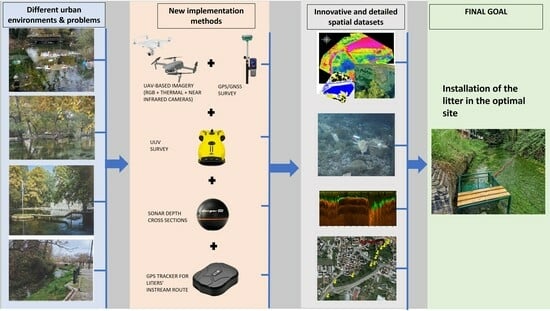
New Technologies to Assess and Map an Urban Riparian Area in Drama, Greece, and Determine Opportunity Sites for Litter Traps

by
Paschalis Koutalakis
1,
Georgios Gkiatas
1,
Valasia Iakovoglou
2 and
George N. Zaimes
1,2,*
1
Geomorphology, Edaphology and Riparian Areas Laboratory (GERi Lab), Department of Forestry and Natural Environment Science, International Hellenic University, University Campus in Drama, 66100 Drama, Greece
2
Unesco Chair Con-Ε-Ect, 66100 Drama, Greece
*
Author to whom correspondence should be addressed.
Sustainability 2023, 15(21), 15620; https://doi.org/10.3390/su152115620
Submission received: 21 August 2023 / Revised: 25 October 2023 / Accepted: 2 November 2023 / Published: 4 November 2023
(This article belongs to the Special Issue Assessment and Sustainable Management of Riparian Ecosystems)

Abstract

:
Riparian areas offer many ecosystem services, especially in urban settings. Their conservation can be complex because of the many urban anthropogenic pressures they face. Adopting new technological approaches can provide insights on the most cost-effective and sustainable management for riparian areas. In this study, different new technological approaches were implemented to assess and map environmental variables and find the optimal location of nature-based solutions (e.g., litter traps). The study area was Agia Varvara Park in Drama, Greece, a unique natural urban riparian area. The approaches utilized were categorized as aerial, terrestrial, and surface/underwater. Specifically, these approaches included unmanned aerial vehicles that incorporated high-resolution regular and thermal cameras to capture the surface environmental conditions and unmanned underwater vehicles to capture the underwater environmental conditions. The produced orthomosaics and digital surface models enabled us to estimate the boundaries of the water surface in Agia Varvara Park. A GPS tracker was also used to record the potential movement route of litter. Finally, a sonar device was utilized to estimate the water depth of potential cross-sections of Agia Varvara’s stream where the litter trap could be installed. The above datasets were used to develop spatial datasets and accompanying maps that were utilized to find the optimal opportunity sites for the litter trap. A litter trap is a floating device that gathers and maintains litter, vegetation, and other debris. Two specific locations were proposed based on water presence, water depth, channel’s width, limited vegetation for accessibility, wildlife existence, litter’s water route, and stopping location time. Such traps enable the collection of anthropogenic litter. In one location, a litter trap has been installed and is being tested. Overall, the above approaches could be used to suggest other nature-based solutions and/or their optimal location, thus enhancing the sustainable management of urban riparian areas.

Graphical Abstract

1. Introduction

Unmanned Aerial Vehicles (UAVs), commonly known as drones, are a tool that continues to expand its applicability in many scientific sectors. This is a result of the many brands and different types of drones (micro, light-weighted, small-scale, rotorcraft, flying wing, etc.) available in the global market [1,2]. The use of UAV systems has seen exponential growth during the 21st century [3]. Furthermore, their cost has decreased, although their technological capabilities and applications have improved [4].
UAVs have proven to be important in many environmental applications, particularly in water resource management [5]. Video and time-averaged images have been used to calculate the surface velocity and water level that allow for the estimation of water discharge [6,7,8,9]. Since they are non-intrusive and safe for the users (they do not need to enter the stream water), they can be used during flooding conditions. UAVs have also been utilized to visualize stream/river water temperature [10], monitor degraded environments, map algae blooms [11], and carry a variety of sensors for water sampling and analysis [12,13]. In addition, UAV-based images have been utilized to categorize riparian areas, streams, and river quality, validated by environmental visual protocols [14,15]. Finally, studies have assessed their utility for monitoring various natural disasters [16,17].
Unmanned underwater vehicles (UUVs) have been used for aquatic monitoring for the last 30–40 years [18]. Their application is primarily for marine, estuary, or coastal environments [19,20]. In contrast, their utilization in rivers, lakes, ponds, and wetlands has been limited [21]. The combination of UUVs and UAVs to study riparian zones, despite the many promising monitoring and assessment applications, has not been exploited to its full potential.
A riparian area is the interface between a land and freshwater body (e.g., stream, river, or lake) [22]. They are semi-aquatic ecotones, transition zones between aquatic and terrestrial ecosystems. As transition areas, they are highly productive and biodiverse because they have characteristics of both adjacent ecosystems [23]. Consequently, riparian areas can offer many ecosystem services and are ecological hotspots [24].
To continue offering the many ecosystem services, riparian areas need to maintain their functions and structures. Unfortunately, many anthropogenic disturbances have degraded these areas, which are further deteriorating because of climate change pressures [25]. These disturbances and pressures might shift stream and river flows in the Mediterranean from perennial to intermittent and from intermittent to ephemeral [23]. These flow alterations also impact riparian vegetation communities. Overall, the riparian areas of the Mediterranean region are considered very sensitive to climate change impacts [23].
Urbanization can have severe negative impacts on riparian areas [26]. It typically does not impact large areas of riparian ecosystems but can still cause severe impacts. Since riparian areas are corridors, their fragmentation by urban areas disrupts many ecosystem services, such as connectivity. In the worst scenarios in urban environments, the native vegetation of riparian areas is completely removed, and in its place, infrastructure is developed, while the streams contain an artificial instream and bank protection structure and are channelized [27]. When the natural vegetation is maintained, the extensive use by the urbanites and the runoff that reaches it from the surrounding impervious environments can lead to extensive pollution, making these biodiversity hotspots extremely vulnerable [28]. Garbage (especially plastics) and chemical contamination are common in urban streams that also impact adjacent riparian areas. The increased impervious area in the watershed and increased stormwater flows substantially contain pollutants entering the stream and altering natural ecosystem processes [29]. Macro- and microplastics in water bodies are becoming one of the most serious environmental concerns [30,31].
In contrast, the sustainable management of urban riparian areas can help the ecological and socioeconomic revitalization of these settings [32]. Specifically, they can improve stream water quality, protect from flood events, enhance aesthetics and recreational opportunities, reduce urban heat island, and mitigate climate change effects. Common management practices include fluvial and geomorphic restoration, active replanting of native trees, and re-establishment of the natural floodplain [33].
Nature-based solutions (NbS) are a valid alternative to gray infrastructure development and/or redesign in urban settings [28]. Healthy, functional urban riparian forests are a common NbS for climate change adaptation in cities [34,35]. The advantages of NbS are that they utilize ecosystem services, are self-sustaining, and help address societal challenges such as climate change, food security, or natural disasters [34]. A key element for successful NbS is the incorporation of socio-ecological, cultural, and ethnographic information during their development [36]. This allows for the implementation of solutions that are sustainable and also more readily adopted by the local communities. In regard to reducing plastics in water bodies, ideal NbS are litter traps [37]. Overall, NbS can be a sustainable tool to mitigate the negative impacts of urbanization while also building resilience for climate change impacts [38]. At the same time, NBS can be a challenge, especially in urban settings, because their implementation requires interdisciplinarity and the complexity of urban governance and planning due to the many and diverse stakeholders. At the same time, if policymakers, stakeholders, and the general public are convinced to mainstream NbS, it will lead to the revolutionization of urban planning practices by supporting the sustainability triangle of societal, economic, and environmental challenges [39]. NbS are living systems [40], which means that urban planning and design need to adopt new approaches. To comprehend and capture the dynamic nature of NbS, more accurate, frequent, and at larger scale data are required (utilizing new technologies) and presented in a user-friendly format to showcase clearly and effectively NbS benefits.
Ecotourism is another management method for safeguarding riparian ecosystems [26]. Riparian areas are an oasis in an urban environment and provide unique ecotourism opportunities. Through ecotourism, urbanites can be educated about the benefits of riparian areas, improve their quality of life, and promote the growth of the local economy [40].
Urban riparian areas in Greece have not been studied extensively, despite their importance in maintaining sustainable cities and mitigating climate change impacts [26]. This study presents the first application in Greece of different new approaches based on new technologies (different UAVs and cameras, a UUV, a sonar, and a GPS tracker) in the urban riparian area of Agia Varvara Park. This is a unique, well-maintained natural riparian ecosystem within the urban fabric of Drama City. The first aim of the study was to assess and map Agia Varvara Park by showcasing the use of new technologies that will allow more quick and/or accurate estimations of different environmental variables. These variables could be utilized by the land and water managers to better understand the current condition and enable them to sustainably manage and implement nature-based solutions. The second aim was, based on some of these variables, to determine optimal opportunity sites to install litter traps. The frequent visitation to the park has led to plastic litter being a major problem, especially during certain events.

2. Materials and Methods

2.1. The Study Area

Drama is the capital of the Drama Regional Unit. It belongs to the Eastern Macedonia and Thrace Region located in Northern Greece (see Figure 1). The city was originally named Ydrama or Dyrama because of the abundant water sources (e.g., springs and streams). The city of Drama has an area of 59 km2 and an altitude of 118 m above sea level. The population of the city is approximately 44,257 people, based on the population’s census of 2021 [41]. The Köppen-Geiger climate classification is Csa (typical Mediterranean climate). The average temperature in Drama is 14.2 °C, and the precipitation is 520 mm yr−1. Recently, there have been efforts to exploit the unique natural ecosystems that are in or surround the city for ecotourism opportunities. An example is the environmentally friendly development of Agia Varvara Park. The Agia Varvara Park (or Saint/Ayia and Barbara/Varvara) is a recreational riparian area that includes a natural pond, natural underground springs, and a perennial stream and is located in the city center (WGS84: 41.149324, 24.141168) (Figure 1). The stream has its lowest flows during the summer months, while the highest have been recorded from February to April. The area showcases high flora and fauna biodiversity, and efforts need to be made to conserve this unique ecosystem. Agia Varvara Park (from this point on) is the most naturally maintained riparian area in an urban setting in all of Greece [26]. It should be used as a successful example of an urban NbS that could be applied to other towns in Greece, the Balkans, and the Mediterranean.
Most of the natural riparian vegetation in the park has been maintained. In addition, eco-friendly paths have been constructed, and especially during the spring and summer, the park is a “hot spot” for leisure and recreational activities, concerts, and festivals. This should be of concern since excessive human utilization could degrade the area. The heaviest pressures occur on the eve of the feast of Agia Varvara (4 December), because of the traditional celebratory custom carried out by the locals and mainly by the children. Handmade miniature boats from matches, twines, wood, styrofoam, and other materials are placed as lanterns on the surface of Agia Varvara pond (Figure 2). The activities of this event require monitoring to assess the potential negative impacts (e.g., pollution by the boats) on its ecosystem’s services. Since NbS addresses socio-cultural-ecological aspects of a problem [40], they are the ideal type of management to resolve this environmental problem that has been created with the miniature boats while at the same time allowing the continuation of this long-lasting tradition. Specifically, an easy solution is the installation of permanent or temporary litter traps at key locations and during key periods to capture the miniature boats. Suggesting easy-to-implement NbS with their technical specifications and new practical approaches for their optimal location should facilitate their further adaptation by municipalities and citizens.

2.2. Assessment and Mapping Approaches, Tools, and Software

The dynamic nature of NbS, along with many and diverse anthropogenic pressures in urban settings, indicates that their implementation and sustainable maintenance require frequent and detailed assessment, mapping, and monitoring. New technologies and approaches can really be beneficial to land and water managers in urban riparian areas. In this study, these assessment approaches were categorized as (a) aerial, (b) terrestrial, (c) surface, and (d) under water.
For the aerial approach, two drones were used: the UAVs DJI Phantom 4 Pro and the DJI Enterprise advanced. Each one is equipped with different types of cameras to provide different environmental data. Specifically, the UAVs DJI Phantom 4 Pro had a Red-Green-Blue (RGB) and near-infrared (NIR) camera, while the DJI Enterprise advanced had an RGB and thermal camera. The UAV DJI Phantom 4 Pro can provide regular images of the area of interest but also NIR images in order to develop the Normalized Difference Vegetation Index (NDVI). The DJI Enterprise advanced also provides regular images but also thermal images.
Two different photogrammetric software programs, Pix4D 4.5.6. and OpenDroneMap, were utilized for the UAV images. Pix4D compiled the regular photos from both drones and produced the orthomosaics and the Digital Surface Models (DSMs) (two different types of maps). The OpenDroneMap compiled the NDVI orthomosaic based on the photos of the DJI Phantom 4 Pro (NIR camera). This index allowed for the determination of the presence of water and vegetation, along with the condition and canopy cover of the vegetation (aerial approach).
The analysis of the products was done in ArcGIS 10.4. Based on the orthomosaic, the boundaries of the water bodies were digitized, and the perimeter and area of the bodies were estimated (utilizing the spatial analysis tool). These measurements were also validated by actual field measurements. The detailed information of the orthomosaic can be readily deciphered in the spatial analysis in ArcGIS 10.4. Specifically, land or water managers can determine the boundaries of different areas of interest (e.g., ponds, parks, etc.).
The Thermal Analysis Tool 2 software was used to compile the captured images by DJI Enterprise advanced and produce the thermal map of the park. This map can indicate thermal differences depending on land cover and also highlight wildlife congregation areas during the night compared to regular images that have limited visibility.
The terrestrial approach measured control points using the Global Position System/Global Navigation Satellite System (GPS/GNSS) Ruide Pulsar R6P. These terrestrial control points were used for the orthorectification of the produced orthomosaics in order to increase their accuracy.
For the surface/underwater approach, the Tristar GPS tracker was used to monitor the floating litter route and the places that they stopped. For floating litter, a miniature boat was used. In addition, for this approach, the Nemo underwater submarine was used to record the underwater environment and the Deeper Smart Sonar Pro to measure bathymetry and temperature at specific cross-sections of interest. Details of the tools and software used follow.

2.2.1. The UAV “DJI Phantom 4 Pro”

The DJI Phantom 4 Pro (Shenzhen DJI Sciences and Technologies Ltd., located in Shenzhen, China) captured the initial airborne images to create the orthomosaic of Agia Varvara Park for the spatial analysis. The specific UAV had the regular RGB camera and the near-infrared (NIR) Agrocam Geo (Norward Expert LLC, located in Debrecen, Hungary) attached. The Agrocam Geo is designed to monitor crop health and provides NGB images with GPS coordinates. The NGB images have three channels, i.e., NIR, G, and B [42]. These images can be used to develop the NDVI index [43]. The UAV flight was conducted on 25 February 2022. The ground sampling distance of the orthomosaic was 1.38 cm and covered an area of 44,000 m2.

2.2.2. The UAV “DJI Enterprise Advanced”

The DJI Enterprise Advanced (Shenzhen DJI Sciences and Technologies Ltd., located in Shenzhen, China) has a dual system including an RGB (Red-Green-Blue) and a thermal camera capable of taking images of particular object categories [44]. These categories included urban areas, water, vegetation, open land, settlements, and industrial factories. Thermal images are useful because they identify objects that are less visible with traditional imagery [45]. The UAV images were used to create an RGB and a thermal orthomosaic. The thermal orthomosaic depicts the surface temperature during the specific flight. The UAV flights were conducted on 25 February and 5 October 2022. The ground sampling distance of the thermal orthomosaic was 2.20 cm and covered an area of 46,000 m2.

2.2.3. The Photogrammetric Software “Pix4D 4.5.6.”

The Pix4Dcapture (Pix4D S.A., located in Prilly, Switzerland) is a mobile application that enables autonomous flight missions and also provides an estimated flight time [46]. The Pix4Dmapper generated the point cloud, the mesh model, the texture, the orthomosaic, the 3D model, and the DSM from the images that were captured from both UAVs.

2.2.4. The Photogrammetric Software “OpenDroneMap”

The NDVI (see Equation (1)) is one of the most worldwide-used remote sensing products for vegetation assessment [47]. It takes values from −1 to +1 [48]. A decrease in “greenness” (values closer to zero) reflects vegetation degradation. The NDVI was produced from the NGB images by utilizing the AgroCam tool and the online software OpenDroneMap [49]. OpenDroneMap is written in Python 3 [50].
NDVI = (NIR − Red)/(NIR + Red)

2.2.5. The Spatial Analysis Software “ArcGIS”

The generated orthomosaics were further analyzed in ArcGIS 10.4 (Environmental Systems Research Institute, Inc., known as ESRI, located in Redlands, CA, USA) [51]. The boundaries of the water surface were digitized manually based on all produced outputs (RGB orthomosaic, DSM, NDVI, thermal), and the spatial analysis toolbox was used to acquire and compare the spatial information (perimeter and area).

2.2.6. The Software “Thermal Analysis Tool 2”

The DJI Thermal Analysis Tool 2 (Shenzhen DJI Sciences and Technologies Ltd., located in Shenzhen, China) analyzed and processed the outputs (as a thermal map) from the thermal camera. The software can identify the temperature information of critical targeted areas [52]. It depicts the image on a colored thermal scale, and the user can select points to check the captured surface temperature [53]. The results are presented as a thermal map.

2.2.7. The GPS/GNSS—RUIDE PULSAR R6P

The GPS/GNSS RUIDE PULSAR R6P (Guangzhou, China) recorded the real coordinates (in WGS 84) to orthorectify the produced outputs (orthomosaic and DSM). The PULSAR R6p can deliver a horizontal accuracy of up to 2 cm [54]. Ground control points (GCPs) are required to improve the geometric accuracy and quality of DSMs and orthomosaic maps [55]. The total number of GCPs used was six, with an accuracy of 10 cm.

2.2.8. The UUV

The Nemo underwater submarine UUV (Shenzhen Aquarobotman Science Technology Co. LTD, Qianhai Shenzhen and Hong Kong Cooperat, Shenzhen, China) is controlled via the free smartphone app for an Apple or an Android. Its connectivity works via a waterproof tether cable and has a quick-swap battery for continuous sea exploration [56]. Nemo uses four thrusters in order to be stable while conducting underwater missions. It has a high-resolution 4K camera (16 MP) [57] to record the underwater environment, including the fauna and flora, but also to spot littering. UUV images were captured on 10 December 2022.

2.2.9. The GPS Tracker

The Tristar GPS tracker was used to perform real-time tracking of floating and sub-floating litter in the stream network. The GPS tracker has an accuracy of 3 m. Its dimensions are 112 × 78 × 28 mm, and its weight is 300 g. The tool can connect to the network with a Global System for Mobile Communication (GSM) or a General Packet Radio Service (GPRS) by utilizing four different bands. A mobile phone called the GPS tracker to retrieve its GPS signal via text message. A miniature boat was constructed to carry a GPS tracker in an airtight container attached to it. This allowed us to monitor and map the route of the boat used in the Agia Varvara event as it traveled through its stream network.

2.2.10. The Sonar Device

Bathymetry measurements were performed with the Deeper Smart Sonar PRO+ (Deeper, Vilnius, Lithuania). This was complimentary to the UUV measurements. The specific device is versatile and provides powerful sonar scans up to a depth of 80 m. Through its secure Wi-Fi connection, it sends detailed information directly to a smartphone or tablet [58]. The sonar device was used for underwater bathymetric measurements. This allows for the determination of the cross-sectional area at specific locations (width and depth) along with the existence of vegetation.

2.3. Litter Trap—Determine Opportunity Sites

Litter in water bodies is increasing exponentially, so cost-effective, durable, and passive (no use of energy) methods need to be employed [59,60]. An example is the litter trap, which is a floating device able to gather and maintain litter, vegetation, and other debris [37]. Typically, barriers that do not obstruct wildlife, fish, or water flow gather the litter in the trap. Once captured, the materials are removed and disposed of. Their popularity seems to be gaining interest because of their effectiveness and efficiency. In addition, they are suitable for most water bodies (e.g., streams, rivers, lakes, and ports) since they can have different designs, dimensions, and holding capacities. Finally, another advantage is that the material gathered can be recycled.
An important element of their effectiveness is selecting the optimal location for their installation. Important parameters to determine the optimal site for the litter trap are: limited human presence (avoid degrading aesthetics); limited presence of wildlife (avoid degrading their habitat); minimal stream bank and stream vegetation; proper width and depth of the stream channel cross-section (disrupt the functionality of the trap); current-carrying capacity; river bed (e.g., too narrow, too shallow, or too wide); stream water level (fluctuations, too high); and ease of emptying. The dimensions of the litter trap in this study were 1 (width) × 2 (length) × 0.5 (height) m. This meant the depth of the channel should be greater than 0.5 m in order for a floating litter trap to be functional.
To find the optimal opportunity sites for the litter trap, the three different assessment approaches described in the previous section were used: (a) aerial, (b) terrestrial, and (c) surface and under water (see Figure 3). The datasets and maps developed based on the assessment approaches were integrated and interpreted for the specified parameters by being overlayed in ArcGIS 10.4 to select opportunity sites optimal for the installation of a litter trap. The cross-sections were selected based on the spatial analysis of the GPS tracker route. Specifically, the different maps indicated areas with human and wildfire activities but also the location where litter accumulates. This information allowed us to select five specific cross-sections as potential opportunity sites. Afterwards, the sonar device tested the cross-sections, assessing their dimensions and the presence of vegetation in the cross-section to see if they were appropriate for the placement of the specific litter trap.
Overall, in this study, we wanted to develop a more practical and applicable approach compared to past studies [61,62]. The reasoning was to be more readily adopted by land and water managers for the installation of litter traps.

3. Results

3.1. Orthomosaic RGB—General Characteristics

The images of the UAV flights enabled us to produce the RGB orthomosaics in the Pix4D software of the studied park and estimate its general characteristics. Through the orthomosaic map (Figure 4), the perimeter (235.6 m) and area (2298.0 m2) of the main pond of Agia Varvara were calculated. This is the proper area where the miniature boats during the celebration event should be placed (blue boundaries in Figure 4). The GPS/GNSS topographic survey estimated a perimeter of 238.8 m and an area of 2309.7 m2. The estimates based on the RGB orthomosaic calculations were very close to the field measurements by the GPS/GNSS. The perimeter and area of the rest of the water surfaces (see yellow boundaries) according to the RGB orthomosaic (including the other ponds/streams) were estimated at 2168.3 m and 11,737.1 m2, respectively. An area of 454.46 m2 with a perimeter of 128.40 m that also represents water surfaces was not captured in the specific orthomosaic because of the vegetation canopy. This missing area was captured by the topographic survey (see red boundaries). The total actual area of the water surfaces in Agia Varvara Park is 14,489.6 m2.
The RGB orthomosaic also enabled the identification of the underwater old ruins of the Agia Varvara church. The ruins are highlighted inside the yellow square (Figure 5A). Furthermore, an experienced “eye” can spot the presence of wildlife, e.g., ducks (Anas), geese (Anser), and swans (Cygnus), as indicated in the white circle (see Figure 5A). The presence of fish (in blue circles) is also visible due to the clear water (Figure 5A,B).

3.2. Digital Surface Model (DSM)

The DSM not only identified the water boundaries but also allowed for the estimation of elevation differences. The lowest elevation values identified corresponded to the water surface (123.4 m). In addition, the DSM provided the height of the trees or buildings in the studied area, which had the highest elevation values. The height of the tallest tree in the park was 31 m, based on the DSM. This is calculated as the difference between the elevation of the water surface and the tallest point (154.8 m) based on the DSM. The canopy cover was also extracted from the DSM (red circles in Figure 6). This is the part of the riparian zone that acts as a shelter for the birds.
The DSM also allows the delineation of human construction and recreation areas (yellow squares) (Figure 6). These structures have easily recognizable patterns (aligned, rounded, or squared forms). The boundaries of the captured image are not of high accuracy. For highly accurate elevation measurements, the UAV should have flown at lower altitudes and also captured oblique angles that were impossible due to the electricity wires and the surrounding buildings. This is a very common and expected disadvantage in delineating boundaries based on orthomosaics because there are not enough common points or images to overlay. Still, it gives the land and water managers preliminary data for the area of interest.

3.3. NDVI

The NIR camera-captured images were used to develop the NDVI in the OpenDroneMap software, which focused on the main permanent pond (the northern part of Agia Varvara Park). The NDVI map (Figure 7) was colorized (red mainly showing the water surface) to validate the water boundary results produced by the RGB orthomosaic. The NDVI map provided information on the vegetation’s conditions in the studied area. Specifically, it helped select cross-sections that had sparse vegetation in order to be able to install the litter trap and easily collect the litter. In addition, the NDVI can indicate where vegetation degradation is happening.

3.4. Thermal Orthomosaic

The thermal camera images enabled the development of a thermal orthomosaic (colorized scale) of the study area (Figure 8A). The Thermal Analysis Tool 2 depicts the temperature for each individual pixel (Figure 8B). The temperature values themselves were not a focal point because the calibration of the images for the entire park was not possible. A validation of the thermal UAV-based surface temperatures on the water’s surface (5 October 2022) was done by using the sonar device to record the temperature. The highest recorded temperature was depicted in running car engines. Interestingly, the temperature of the water bodies was higher than the temperature of the urban environment, such as roads, pavement, and buildings (Figure 8). The vegetated part of the park had lower temperatures compared to the buildings and roads/pavements, as expected (Figure 8).
Thermal imaging was also used to highlight the presence of wildlife, e.g., ducks (Anas) and swans (Cygnus). This information allows us to find potential places to install a litter trap that do not negatively impact wildlife. Real-time movement of these animals can also be recorded, if needed, on the water’s surface (Figure 9).

3.5. Unmanned Underwater Vehicle

The UUV captured underwater positions that can act as litter gathering points or underwater constructions, such as the old ruins of the church (Figure 10). Places with dense underwater vegetation and standing water due to low water levels, places with vorticity, or places with the absence of currents’ activity were identified. In addition, the presence of wildlife, e.g., ducks and fish, was located (Figure 10). These are important parameters to consider in order to find the optimal location for the placement of a litter trap.

3.6. GPS Tracker

The GPS tracker was used to show the potential course of a miniature boat (considered a potential litter pollutant) through the stream network (Figure 11 and Table 1). The GPS tracker finally stopped at a human-built structure (a small dam) and afterwards malfunctioned; thus, its signal (location) was lost after 5 days of recording. During its course, the tracked boat systematically stopped at various locations, from minutes to hours or even days. Since no rainfall phenomena were recorded during the monitoring period, weather conditions had no impact on the route or locations where it stopped. The parameters that affected the tracker were the vegetation, the geomorphology of the channel, and the human intervention (water barriers/small dams). This route is showcased in Figure 11, and the stopping locations were validated by actual field observations. The results showed that the residence time of these litters is much longer than the transit time of water. This is important because it offers the opportunity to collect them before they get fragmented into macroplastics or miscroplastics and/or reach the sea or other water bodies.

3.7. Sonar Results—Optimal Litter Trap Location

The sonar surveyed five cross-sections as potential locations where the litter trap could be placed. These locations were selected based on where the GPS tracker stopped and the characteristics described in Table 2 at potential opportunity sites for the installation of the litter trap. Figure 12 presents the initial cross-sections at these five locations. The water temperature captured by the sonar was compared with the same cross-sections depicted in the thermal images in Thermal Analysis Tool 2. The cross-section results for the thermal orthomosaic (see Figure 8) and the sonar (see Figure 12) were identical. The numbering of each cross-section is based on the GPS tracker stopping locations (see Table 1). The sonar images in Figure 12 depict the cross-section width and depth, the vegetation, the stream bed, and the water depth. According to these images, cross-section No. 4 would not be suitable to install a litter trap since the water level does not exceed 0.5 m. This would not fit the dimensions of the litter trap. In addition, the area is very close to wildlife habitat and is frequently visited, so the installation will degrade its aesthetic value. In cross-section No. 5, the depth of the water varies from 0.5 m to 1.5 m. This particular cross-section is ideal for the installation of the trap, not only in regard to its depth but also because of the lack of wildlife. In the first 13 m of cross-section No. 6, the water depth varies from 0.6 m to 1 m. In the remaining 10 m, the depth is less than 0.4 m. So, within 0–13 m of the cross-section, the litter trap could be placed. Cross-section No. 8 could be a location for the installation of the trap due to its water depth but also its short width, which means more efficient litter collection. Unfortunately, the man-made construction (there is a bridge) creates water eddies that sink the litter, making it very difficult to collect it. In addition, the specific location has underwater vegetation, as depicted in the image, which also reduces the utility of the litter trap. Finally, cross-section No. 18 appears to be a suitable location to place the litter trap because it is far away from the main routes of Agia Varvara Park, thus not interfering with the wildlife and the tourists. Another advantage is that it could gather litter originating from a greater area, including agricultural and industrial areas. Unfortunately, this location has dense vegetation and is characterized by high stream flows that could result in the possible malfunction of the litter trap. In summary, after the analysis of the parameters (e.g., water depth and flow, cross-section width, vegetation, wildlife, human, and infrastructure presence), the optimal locations to install the litter trap were cross-sections No. 5 or 6.
The litter trap was placed in cross-section No. 6 in order to test its functionality in the summer months of 2023 (Figure 13). The litter trap was placed on the left bank of the channelized stream next to infrastructure that acts as a platform; thus, the litter trap is easily accessible by humans and vehicles to collect the litter. The litter trap is placed safely, and there is no way for it to be removed by the water flows. There is a floating pattern of chained pieces of wood, which leads and accumulates the floating litter into the litter trap. There are already recorded results, with a considerable volume of litter that is collected periodically, especially plastic bottles and straws but also Platanus leaves. Still, the litter trap needs to be checked during a longer and wetter period, as well as during the Agia Vavara celebratory event.

4. Discussion

The application of different new technologies to assess and map environmental parameters and to find the optimal opportunity sites for the installation of a NbS to mitigate the plastic pollution in the urban riparian area of Agia Varvara Park in Drama, Greece, is showcased in this study. Three different approaches were utilized: (a) aerial, (b) terrestrial, and (c) surface and under water. The methods of each approach were applied initially separately, and afterwards their results were integrated to provide the final assessment. Depending on the objectives of the land and water managers, all or part of the methods and approaches should be utilized.
Initially, the water surface boundaries (assessed by the RGB orthomosaic’s analysis and field topographic survey) were determined. The new technologies allow the accurate and large-scale estimation of boundaries (e.g., water bodies) that can improve management plans. Next, any infrastructure close to the streams was identified (by the DSMs) since they could act as a platform for the placement and monitoring of the litter trap. The next step was to map the riparian vegetation’s presence and health (assessed by the NDVI orthomosaic’s analysis). The vegetation maps are important for the placement of the litter trap in order to avoid dense deciduous vegetation that may fill the litter trap with a great volume of leaves and to also have easy access by responsible authorities to gather the collected material without difficulties. Additionally, the presence and paths of local wildlife habitats (assessed by the thermal images’ analysis and the UUV survey) showcased locations to be avoided for the placement of litter traps since the trip would impact their habitat. The route, time, and concentration locations of the floating litter (assessed by the GPS tracker) and the selected cross-section dimensions (assessed by the bathymetric sonar measurements) were the final data to find the optimal places to install the litter trap. The routes enabled us to find any location of standing water, thus standing floating litter that could be gathered, while the cross-section dimensions were necessary for the selection of optimal sites based on the dimensions of the floating device and the capacity and ability not to affect the wildlife paths and presence. The approaches presented provide accurate science-based data that can be utilized by others to help with the proper and efficient installation of NbS.
UAV-based RGB images have been successfully used worldwide to produce photogrammetric products (e.g., orthomosaics) for various environmental applications, assessments, and mapping [63,64,65]. Such assessments and maps have been utilized in riparian areas [66,67,68], but have been limited in their application in urban riparian environments [69,70]. Thermal cameras, although more expensive, are helpful for the environmental-ecological assessment of water resources. The analysis of the produced images provides detailed and accurate data, particularly when coupled with UAVs, on water temperature, quality, and wildlife presence [11,71]. The images from these cameras can provide detailed temperature data, thus providing information that can be utilized by decision-makers for the implementation of best management practices. For example, this study shows that the presence of vegetation can reduce the urban heat island effect. Furthermore, during the night, when visibility is low or absent, temperature differences can showcase the presence of wildlife from the surrounding environment, which allows for the location of habitat hotspots [72,73]. This allows land and water managers to protect them effectively.
Urban riparian areas face many diverse pressures, particularly anthropogenic [26,74]. Remote sensing technologies and UAV-based imagery can capture and analyze the environmental status of the riparian areas by providing very detailed and accurate information at larger scales [75,76,77,78]. This information includes a mapping of the vegetation and an assessment of its health, along with the locations of frequently flooded areas [79]. Such information can be utilized by land and water managers to implement NbS cost-effectively. Potential solutions for urban riparian areas could be replanting trees in bare areas, reinforcing or reshaping banks that are eroding, and protecting certain areas that show degradation by restricting access or altering trails [80]. In this study, the produced NDVI imagery assessed the presence of riparian areas (see Figure 7). This allows us to find areas that need better conservation (restrict access) or areas where riparian vegetation should be re-established (fallen trees or bare areas). Overall, the products based on the study approaches can help citizens and policymakers better understand activities that are harmful to riparian ecosystems.
The study area is a unique aquatic and semi-aquatic ecosystem in an urban environment. It provides many ecosystem services to its citizens (e.g., relaxation and recreation areas), but it is also an ecotouristic attraction for visitors. Without proper measures, its degradation is very likely to occur, as it is already visible in some cases. For example, the images from this study captured degradation activities such as littering in the stream channel (see Figure 10). The public’s awareness is the most preemptive protection option that should be implemented. It can improve, immediately, the sustainable management of urban and sub-urban riparian areas. Awareness activities should focus on presenting to the public the many ecosystem services that riparian areas can offer to humans. This can be done by developing ecotouristic paths in Agia Varvara that also highlight simple conservation activities that each citizen can do to protect their urban treasure. The GERi lab from the International Hellenic University has taken such an initiative. Specifically, information signs (a total of 5) and one information board have been placed in the area with important historical information and the ecological benefits of the area. This activity should be further developed with additional signs and boards. In addition, GERi lab has suggested ecotouristic routes to the municipality that connect the environmental and cultural characteristics of Drama City, which could help improve its attractiveness to tourists [81].
An advantage of maintaining or establishing green vegetated places in cities and towns is to mitigate the urban heat island effect [82,83]. This was clearly indicated by the thermal imaging of this study (see Figure 8 and Figure 9). Actions in the relatively “green” city of Drama should be taken to further promote the greening of the infrastructure instead of implementing classic engineering infrastructure solutions. The conversion of gray to green infrastructure, along with the existing green-blue infrastructure, would benefit urban and peri-urban areas. Such approaches have been implemented successfully in other urban areas, e.g., Sunnyside, Houston, USA [84]. In addition, such solutions are promoted by the EU Green Deal [85]. Ideally, Drama City should try to connect its green areas, e.g., Agia Varvara Park and Central City Park, throughout its urban fabric, which should reduce temperatures during the summer. If such actions are implemented, this would establish Drama as a pioneering and prototype eco-friendly city in Greece. The methods utilized in this study can provide the necessary background and spatial information to land and water managers and decision-makers to assess and map current conditions for the optimal placement of urban green and blue NbS. The results of these tools are easy to read and interpret, making them more likely to be accepted by the general public.
The miniature boats that are placed in the water bodies of the park during the celebration event may eventually turn into litter. Since this tradition will continue, the municipality and local NGOs need to find sustainable solutions for this environmental issue. These boats can be a major source of different-size plastics, one of the most serious environmental problems for water bodies [86,87]. The GPS tracking identified the potential route of surface water-moving litter, their chronic distribution in the channel, and the areas where stopping was more frequent and intense. If rainfall events had occurred, it would result in higher and faster water velocities and discharges that would alter the time scale, increasing the speed of litter movement. The lower temperatures (the event is in the winter) can cause water to freeze, thus increasing accumulation in certain positions. Different climatic or hydrologic conditions alter water flow and also litter concentration, which could range from hours/days (high/low flows) to weeks/months (spring flows, typically the highest) and years (seasonal river flow, vegetation, and geomorphological aspects limiting movement) [88]. Thus, the route of plastic litter is highly chaotic, with many parameters interacting (e.g., weather conditions, water level, water flow, vegetation, geomorphology of the water courses, human constructions, etc.) [89]. One of the most promising solutions appears to be the public’s involvement. For example, volunteer teams of youngsters (university and high school) have tried to collect litter in its riparian zones, while scuba divers have removed litter from the underwater areas.
Another focal point for the sustainable management of the park is the proper placement of the released miniature boats to minimize their environmental impacts. Based on the digitization of the water bodies and the maps developed, the proper placement location is in the main constructed pond, and all other flowing water channels in the park should be excluded. In the constructed pond, the boats are in a controlled environment and can easily be collected. This is important for the sustainability of the riparian area and the stream network as it transports the material and pollutes downstream. A campaign has started with a video that was produced and uploaded to a YouTube channel [90] by AMKE ROOTS NGO. This video informs the locals and visitors about the proper release location and the proper construction material of the miniature boats.
Since it is very likely that people might still place the miniature boats in incorrect locations, the placement of permanent or temporary litter traps in the stream network of Agia Varvara Park is another promising, efficient, and practical NbS to capture the boats and other litter. These traps should be made of environmentally friendly material and will collect anthropogenic litter (e.g., handmade miniature boats). The litter traps could also be assisted by an alarm system to help the responsible authorities monitor their status (e.g., to provide a signal when they are filled with litter and need to be cleaned). The municipality, volunteer groups, or ideally both in collaboration, should be responsible for litter trap preservation and clean-up [91]. The approaches utilized in the study allow us to find their optimal location utilizing science-based, accurate datasets. Specifically, in cross-section No. 6 a litter trap was placed. In the future, more parameters could be studied, such as vorticity and streamflow, to provide better information on the proper way to best secure the litter trap from high-flow events.

5. Conclusions

The assessment datasets and accompanying maps of this park, based on the three approaches, allowed us to suggest best management practices and where there is a need to install NbS. Two optimal opportunity sites for litter traps (NbS) to capture the traditional miniature boats were determined, and in one of them, the litter trap was installed. The spatially detailed data developed by the innovative approaches allows the effective, efficient, science-based, and targeted implementation of NbS (e.g., litter traps) that will enhance the sustainable management of urban riparian areas. These approaches increase the temporal frequency of the measurements needed for sustainable management under urban anthropogenic pressures. Limitations occur when the vegetation density and tree cover are high, which can lead to images with incomplete coverage of the studied area. The updated management suggestions of the study can enhance the protection of this vulnerable ecotone by reducing anthropogenic litter and improving current ecotourism activities. At the same time, the protection of the park will also promote climate change mitigation and adaptation and enhance the overall quality of life for the citizens of Drama.
Overall, these methods can easily be applied in other urban riparian areas of Greece and the Mediterranean. Land and water managers would benefit from accurate and detailed spatial data with high temporal frequency to implement sustainable management practices. In addition, because the results are easy to understand and interpret by decision-makers and the general public, the suggested management solutions will most likely be accepted and eventually transformed into policy measures. The utilization of the proposed approaches can lead to the science-based and target installation of NbS. The main initial deterrent is the cost of the tools.
Further recommended actions to achieve sustainable management of the park include: (a) enhancing locals’ awareness; (b) promoting opportunities to receive subsidies to develop private NbS projects from regional or national governance bodies; and (c) developing proper restoration plans for the current or future green and blue areas by the land and water managers. The sustainability of Agia Varvara Park can also provide economic benefits by increasing ecotourism visitors, mitigating climate change impacts, and providing recreation opportunities, healthier lifestyles, and overall better welfare for its citizens.

Author Contributions

Conceptualization, P.K. and G.N.Z.; methodology, P.K. and G.G.; software, P.K. and G.G.; validation P.K., G.N.Z. and V.I.; analysis, P.K., G.N.Z. and G.G.; writing—original draft preparation, P.K.; writing—review and editing, G.N.Z. and V.I.; visualization, P.K. and G.G.; supervision, G.N.Z.; project administration, G.N.Z.; funding acquisition, G.N.Z. All authors have read and agreed to the published version of the manuscript.

Funding

This research (Project BSB963 Protect-Streams-4-Sea) was funded by the Joint Operational Black Sea Programme 2014–2020 with the financial assistance of the European Union. The content of this publication is the sole responsibility of the authors, and it does not reflect the views of the European Union.

Institutional Review Board Statement

Not applicable.

Informed Consent Statement

Not applicable.

Data Availability Statement

Data are contained within the article.

Conflicts of Interest

The authors declare no conflict of interest.

References

  1. Mohsan, S.A.H.; Khan, M.A.; Noor, F.; Ullah, I.; Alsharif, M.H. Towards the unmanned aerial vehicles (UAVs): A comprehensive review. Drones 2022, 6, 147. [Google Scholar] [CrossRef]
  2. Cai, G.; Dias, J.; Seneviratne, L. A survey of small-scale unmanned aerial vehicles: Recent advances and future development trends. Unmanned Syst. 2014, 2, 175–199. [Google Scholar] [CrossRef]
  3. Estrada, M.A.R.; Ndoma, A. The uses of unmanned aerial vehicles–UAV’s-(or drones) in social logistic: Natural disasters response and humanitarian relief aid. Procedia Comput. Sci. 2019, 149, 375–383. [Google Scholar] [CrossRef]
  4. Zohdi, T. The Game of Drones: Rapid agent-based machine-learning models for multi-UAV path planning. Comput. Mech. 2020, 65, 217–228. [Google Scholar] [CrossRef]
  5. Vélez-Nicolás, M.; García-López, S.; Barbero, L.; Ruiz-Ortiz, V.; Sánchez-Bellón, Á. Applications of unmanned aerial systems (UASs) in hydrology: A review. Remote Sens. 2021, 13, 1359. [Google Scholar] [CrossRef]
  6. Koutalakis, P.; Tzoraki, O.; Zaimes, G. UAVs for hydrologic scopes: Application of a low-cost UAV to estimate surface water velocity by using three different image-based methods. Drones 2019, 3, 14. [Google Scholar] [CrossRef]
  7. Fujita, I.; Notoya, Y.; Tani, K.; Tateguchi, S. Efficient and accurate estimation of water surface velocity in STIV. Environ. Fluid Mech. 2019, 19, 1363–1378. [Google Scholar] [CrossRef]
  8. Ridolfi, E.; Manciola, P. Water level measurements from drones: A pilot case study at a dam site. Water 2018, 10, 297. [Google Scholar] [CrossRef]
  9. Koutalakis, P.; Zaimes, G.N. River Flow Measurements Utilizing UAV-Based Surface Velocimetry and Bathymetry Coupled with Sonar. Hydrology 2022, 9, 148. [Google Scholar] [CrossRef]
  10. Handcock, R.N.; Torgersen, C.E.; Cherkauer, K.A.; Gillespie, A.R.; Tockner, K.; Faux, R.; Tan, J.; Carbonneau, P.E. Thermal infrared remote sensing of water temperature in riverine landscapes. In Fluvial Remote Sensing for Science and Management; John Wiley & Sons: New York, NY, USA, 2012; pp. 85–113. [Google Scholar]
  11. Kislik, C.; Dronova, I.; Kelly, M. UAVs in support of algal bloom research: A review of current applications and future opportunities. Drones 2018, 2, 35. [Google Scholar] [CrossRef]
  12. Lally, H.T.; O’Connor, I.; Jensen, O.P.; Graham, C.T. Can drones be used to conduct water sampling in aquatic environments? A review. Sci. Total Environ. 2019, 670, 569–575. [Google Scholar] [CrossRef]
  13. Adão, T.; Hruška, J.; Pádua, L.; Bessa, J.; Peres, E.; Morais, R.; Sousa, J.J. Hyperspectral imaging: A review on UAV-based sensors, data processing and applications for agriculture and forestry. Remote Sens. 2017, 9, 1110. [Google Scholar] [CrossRef]
  14. Rivas Casado, M.; Ballesteros Gonzalez, R.; Kriechbaumer, T.; Veal, A. Automated identification of river hydromorphological features using UAV high resolution aerial imagery. Sensors 2015, 15, 27969–27989. [Google Scholar] [CrossRef]
  15. Latsiou, A.; Kouvarda, T.; Stefanidis, K.; Papaioannou, G.; Gritzalis, K.; Dimitriou, E. Pressures and status of the riparian vegetation in Greek rivers: Overview and preliminary assessment. Hydrology 2021, 8, 55. [Google Scholar] [CrossRef]
  16. Antoine, R.; Lopez, T.; Tanguy, M.; Lissak, C.; Gailler, L.; Labazuy, P.; Fauchard, C. Geoscientists in the sky: Unmanned aerial vehicles responding to geohazards. Surv. Geophys. 2020, 41, 1285–1321. [Google Scholar] [CrossRef]
  17. Erdelj, M.; Natalizio, E.; Chowdhury, K.R.; Akyildiz, I.F. Help from the sky: Leveraging UAVs for disaster management. IEEE Pervasive Comput. 2017, 16, 24–32. [Google Scholar] [CrossRef]
  18. Watson, S.; Duecker, D.A.; Groves, K. Localisation of unmanned underwater vehicles (UUVs) in complex and confined environments: A review. Sensors 2020, 20, 6203. [Google Scholar] [CrossRef]
  19. Kalwa, J.; Tietjen, D.; Carreiro-Silva, M.; Fontes, J.; Brignone, L.; Gracias, N.; Ridao, P.; Pfingsthorn, M.; Birk, A.; Glotzbach, T.; et al. The european project morph: Distributed uuv systems for multimodal, 3d underwater surveys. Mar. Technol. Soc. J. 2016, 50, 26–41. [Google Scholar] [CrossRef]
  20. Mahrad, B.E.; Newton, A.; Icely, J.D.; Kacimi, I.; Abalansa, S.; Snoussi, M. Contribution of remote sensing technologies to a holistic coastal and marine environmental management framework: A review. Remote Sens. 2020, 12, 2313. [Google Scholar] [CrossRef]
  21. Basu, S.; Ahmed, A.; Debnath, A. Hydrone: IoT enabled Autonomous Underwater Vehicle for Aquatic Ecosystem Monitoring. In Applications of Machine Intelligence in Engineering, 1st ed.; Mandal, J.K., SMisra, S., Banerjee, J.S., Nayak, S., Eds.; CRC Press: Boca Raton, FL, USA, 2022; pp. 591–598. [Google Scholar]
  22. Naiman, R.J.; Decamps, H. The ecology of interfaces: Riparian zones. Annu. Rev. Ecol. Evol. Syst. 1997, 28, 621–658. [Google Scholar] [CrossRef]
  23. Zaimes, G.N.; Iakovoglou, V. Assessing riparian areas of Greece—An overview. Sustainability 2020, 13, 309. [Google Scholar] [CrossRef]
  24. Monk, W.A.; Compson, Z.G.; Choung, C.B.; Korbel, K.L.; Rideout, N.K.; Baird, D.J. Urbanisation of floodplain ecosystems: Weight-of-evidence and network meta-analysis elucidate multiple stressor pathways. Sci. Total Environ. 2019, 684, 741–752. [Google Scholar] [CrossRef] [PubMed]
  25. Chiu, M.-C.; Leigh, C.; Mazor, R.; Cid, N.; Resh, V. Anthropogenic threats to intermittent rivers and ephemeral streams. In Intermittent Rivers and Ephemeral Streams: Ecology and Management; Datry, T., Bonada, N., Boulton, A.J., Eds.; Elsevier, Inc.: Cambridge, MA, USA, 2017; pp. 433–454. [Google Scholar]
  26. Iakovoglou, V.; Zaimes, G.N.; Gounaridis, D. Riparian areas in urban settings: Two case studies from Greece. Int. J. Innov. Sustain. Dev. 2013, 7, 271–288. [Google Scholar] [CrossRef]
  27. Barnosky, A.D.; Hadly, E.A.; Bascompte, J.; Berlow, E.L.; Brown, J.H.; Fortelius, M.; Getz, W.M.; Harte, J.; Hastings, A.; Marquet, P.A.; et al. Approaching a state shift in Earth’s biosphere. Nature 2012, 486, 52–58. [Google Scholar] [CrossRef] [PubMed]
  28. Cao, Y.; Natuhara, Y. Effect of Urbanization on Vegetation in Riparian Area: Plant Communities in Artificial and Semi-Natural Habitats. Sustainability 2020, 12, 204. [Google Scholar] [CrossRef]
  29. White, M.D.; Greer, K.A. The effects of watershed urbanization on the stream hydrology and riparian vegetation of Los Peñasquitos Creek, California. Landsc. Urban Plan. 2006, 74, 125–138. [Google Scholar] [CrossRef]
  30. Barboza, L.G.A.; Cózar, A.; Gimenez, B.C.G.; Barros, T.B.; Kershaw, P.J.; Guilhermino, L. Chapter 17—Macroplastics Pollution in the Marine Environment. In World Seas: An Environmental Evaluation, 2nd ed.; Sheppard, C., Ed.; Academic Press: Cambridge, MA, USA, 2019; pp. 305–328. [Google Scholar]
  31. Anik, A.H.; Hossain, S.; Alam, M.; Sultan, M.B.; Hasnine, M.D.T.; Rahman, M.M. Microplastics pollution: A comprehensive review on the sources, fates, effects, and potential remediation. Environ. Nanotechnol. Monit. Manag. 2021, 16, 100530. [Google Scholar]
  32. Stella, J.C.; Rodríguez-González, P.M.; Dufour, S.; Bendix, J. Riparian vegetation research in Mediterranean-climate regions: Common patterns, ecological processes, and considerations for management. Hydrobiologia 2013, 719, 291–315. [Google Scholar] [CrossRef]
  33. González, E.; Sher, A.A.; Tabacchi, E.; Masip, A.; Poulin, M. Restoration of riparian vegetation: A global review of implementation and evaluation approaches in the international, peer-reviewed literature. J. Environ. Manag. 2015, 158, 85–94. [Google Scholar] [CrossRef]
  34. Haase, D. Urban Wetlands and Riparian Forests as a Nature-Based Solution for Climate Change Adaptation in Cities and Their Surroundings. In Nature-Based Solutions to Climate Change Adaptation in Urban Areas—Linkages between Science, Policy and Practice; Theory and Practice of Urban Sustainability Transitions; Kabisch, N., Korn, H., Stadler, J., Bonn, A., Eds.; Springer: Cham, Switzerland, 2017; pp. 111–122. [Google Scholar]
  35. Koutsovili, E.I.; Tzoraki, O.; Kalli, A.A.; Provatas, S.; Gaganis, P. Participatory approaches for planning nature-based solutions in flood vulnerable landscapes. Environ. Sci. Policy 2023, 140, 12–23. [Google Scholar] [CrossRef]
  36. Lemes de Oliveira, F.; do Carmo de Lima Bezerra, M.; Teba, T.; Oliveira, A.d.N. The Environment-Culture-Technology Nexus Framework: An Approach for Assessing the Challenges and Opportunities for Implementing Nature-Based Solutions in Brazil. In Nature-Based Solutions for Sustainable Urban Planning; Contemporary Urban Design Thinking; Mahmoud, I.H., Morello, E., Lemes de Oliveira, F., Geneletti, D., Eds.; Springer: Cham, Switzerland, 2022; pp. 69–102. [Google Scholar]
  37. Raymond, C.M.; Frantzeskaki, N.; Kabisch, N.; Berry, P.; Breil, M.; Nita, M.R.; Geneletti, D.; Calfapietra, C. A framework for assessing and implementing the co-benefits of nature-based solutions in urban areas. Environ. Sci. Policy 2017, 77, 15–24. [Google Scholar] [CrossRef]
  38. Mahmoud, I.H.; Morello, E.; Vona, C.; Benciolini, M.; Sejdullahu, I.; Trentin, M.; Pascual, K.H. Setting the social monitoring framework for nature-based solutions impact: Methodological approach and pre-greening measurements in the case study from CLEVER cities Milan. Sustainability 2021, 13, 9672. [Google Scholar] [CrossRef]
  39. Frantzeskaki, N.; Mahmoud, I.H.; Morello, E. Nature-Based Solutions for Resilient and Thriving Cities: Opportunities and Challenges for Planning Future Cities. In Nature-Based Solutions for Sustainable Urban Planning; Contemporary Urban Design Thinking; Mahmoud, I.H., Morello, E., Lemes de Oliveira, F., Geneletti, D., Eds.; Springer: Cham, Switzerland, 2022; pp. 3–17. [Google Scholar]
  40. Arif, M.; Behzad, H.M.; Tahir, M.; Li, C. The impact of ecotourism on ecosystem functioning along main rivers and tributaries: Implications for management and policy changes. J. Environ. Manag. 2022, 320, 115849. [Google Scholar] [CrossRef]
  41. Hellenic Statistical Authority—Census 2021. Available online: https://www.statistics.gr/2021-census-pop-hous-results (accessed on 15 March 2023).
  42. AgroCam NDVI Camera. Available online: https://www.agrocam.eu/ (accessed on 25 January 2023).
  43. Duffy, J.P.; Pratt, L.; Anderson, K.; Land, P.E.; Shutler, J.D. Spatial assessment of intertidal seagrass meadows using optical imaging systems and a lightweight drone. Estuar. Coast. Shelf Sci. 2018, 200, 169–180. [Google Scholar] [CrossRef]
  44. Darettamarlan, R.R.; Hidayat, H.; Darminto, M.R. Correlation analysis of Land Surface Temperature (LST) measurement using DJI Mavic Enterprise Dual Thermal and Landsat 8 Satellite Imagery (case study: Surabaya City). IOP Conf. Ser. Earth Environ. Sci. 2021, 936, 012037. [Google Scholar] [CrossRef]
  45. Metcalfe, M.W. Investigating the Potential for Hazard Tree Identification Using Thermal Imagery from the DJI Mavic 2 Enterprise Dual. Bachelor’s Thesis, Lakehead University, Thunder Bay, ON, USA, 2019. [Google Scholar]
  46. Aliane, N.; Muñoz, C.Q.G.; Sánchez-Soriano, J. Web and MATLAB-Based Platform for UAV Flight Management and Multispectral Image Processing. Sensors 2022, 22, 4243. [Google Scholar] [CrossRef]
  47. Huang, S.; Tang, L.; Hupy, J.P.; Wang, Y.; Shao, G. A commentary review on the use of normalized difference vegetation index (NDVI) in the era of popular remote sensing. J. For. Res. 2021, 32, 1–6. [Google Scholar] [CrossRef]
  48. Meneses-Tovar, C.L. NDVI as indicator of degradation. Unasylva 2011, 62, 39–46. [Google Scholar]
  49. Vacca, G. Overview of open source software for close range photogrammetry. In Proceedings of the 2019 Free and Open Source Software for Geospatial, FOSS4G 2019 of International Society for Photogrammetry and Remote Sensing, Bucharest, Romania, 26–30 August 2019. [Google Scholar]
  50. Drone Mapping Software—OpenDroneMap. Available online: http://opendronemap.org/ (accessed on 25 January 2023).
  51. Palma, M.; Rivas Casado, M.; Pantaleo, U.; Cerrano, C. High resolution orthomosaics of African coral reefs: A tool for wide-scale benthic monitoring. Remote Sens. 2017, 9, 705. [Google Scholar] [CrossRef]
  52. DJI Thermal Analysis Tool 2.1. Available online: https://www.dji.com/gr/downloads/softwares/dji-dtat2 (accessed on 25 January 2023).
  53. Rodríguez, M.V.; Melgar, S.G.; Márquez, J.M.A. Assessment of aerial thermography as a method of in situ measurement of radiant heat transfer in urban public spaces. Sustain. Cities Soc. 2022, 87, 104228. [Google Scholar] [CrossRef]
  54. RUIDE PULSAR R6p. Available online: https://www.ruide.xyz/r6p (accessed on 25 January 2023).
  55. Han, X.; Thomasson, J.A.; Xiang, Y.; Gharakhani, H.; Yadav, P.K.; Rooney, W.L. Multifunctional ground control points with a wireless network for communication with a UAV. Sensors 2019, 19, 2852. [Google Scholar] [CrossRef]
  56. NEMO Underwater Drone. Available online: https://hse-uav.com/products/nemo-underwater-drone (accessed on 25 January 2023).
  57. Allotta, B.; Brandani, L.; Casagli, N.; Costanzi, R.; Mugnai, F.; Monni, N.; Natalini, M.; Ridolfi, A. Development of Nemo remotely operated underwater vehicle for the inspection of the Costa Concordia wreck. J. Eng. Marit. Environ. 2017, 231, 3–18. [Google Scholar] [CrossRef]
  58. Deeper Sonar PRO+. Available online: https://deepersonar.com/us/en_us/products/deeper-smart-sonar-pro-plus (accessed on 25 January 2023).
  59. Beaumont, N.J.; Aanesen, M.; Austen, M.C.; Börger, T.; Clark, J.R.; Cole, M.; Hooper, T.; Lindeque, P.K.; Pascoe, C.; Wyles, K.J. Global ecological, social and economic impacts of marine plastic. Mar. Pollut. Bull. 2019, 142, 189–195. [Google Scholar] [CrossRef]
  60. Jambeck, J.R.; Geyer, R.; Wilcox, C.; Siegler, T.R.; Perryman, M.; Andrady, A.; Narayan, R.; Law, K.L. Plastic waste inputs from land into the ocean. Science 2015, 347, 768–771. [Google Scholar] [CrossRef]
  61. Battawi, A.; Mallon, E.; Vedral, A.; Sparks, E.; Ma, J.; Marufuzzaman, M. In-Stream Marine Litter Collection Device Location Determination Using Bayesian Network. Sustainability 2022, 14, 6147. [Google Scholar] [CrossRef]
  62. Geneletti, D.; Cortinovis, C.; Orta-Ortiz, M.S.; Kato-Huerta, J.; Longato, D.; Falco, E. Mainstreaming Nature-Based Solutions in Cities Through Performance-BasedPlanning: A Case Study in Trento, Italy. In Nature-Based Solutions for Sustainable Urban Planning; Contemporary Urban Design Thinking; Mahmoud, I.H., Morello, E., Lemes de Oliveira, F., Geneletti, D., Eds.; Springer: Cham, Switzerland, 2022; pp. 19–46. [Google Scholar]
  63. Eisenbeiss, H.; Sauerbier, M. Investigation of UAV systems and flight modes for photogrammetric applications. Photogramm. Rec. 2011, 26, 400–421. [Google Scholar] [CrossRef]
  64. Mancini, F.; Salvini, R. Applications of photogrammetry for environmental research. ISPRS Int. J. Geo-Inf. 2019, 8, 542. [Google Scholar] [CrossRef]
  65. Rusnák, M.; Goga, T.; Michaleje, L.; Šulc Michalková, M.; Máčka, Z.; Bertalan, L.; Kidová, A. Remote Sensing of Riparian Ecosystems. Remote Sens. 2022, 14, 2645. [Google Scholar] [CrossRef]
  66. Dunford, R.; Michel, K.; Gagnage, M.; Piégay, H.; Trémelo, M.L. Potential and constraints of Unmanned Aerial Vehicle technology for the characterization of Mediterranean riparian forest. Int. J. Remote Sens. 2009, 30, 4915–4935. [Google Scholar] [CrossRef]
  67. Huylenbroeck, L.; Laslier, M.; Dufour, S.; Georges, B.; Lejeune, P.; Michez, A. Using remote sensing to characterize riparian vegetation: A review of available tools and perspectives for managers. J. Environ. Manag. 2020, 267, 110652. [Google Scholar] [CrossRef] [PubMed]
  68. Lobo Torres, D.; Queiroz Feitosa, R.; Nigri Happ, P.; Cué La Rosa, E.L.; Marcato Junior, J.; Martins, J.; Olã Bressan, P.; Nunes Gonçalves, W.; Liesenberg, V. Applying fully convolutional architectures for semantic segmentation of a single tree species in urban environment on high resolution UAV optical imagery. Sensors 2020, 20, 563. [Google Scholar] [CrossRef]
  69. Sessanna, R.; Iavorivska, L.; Kelleher, C. Applying multispectral UAV imagery to delineate in and near stream cover along a small urban stream. River Res. Appl. 2022, 38, 717–726. [Google Scholar] [CrossRef]
  70. Langhammer, J. UAV monitoring of stream restorations. Hydrology 2019, 6, 29. [Google Scholar] [CrossRef]
  71. Dimitriou, E.; Stavroulaki, E. Assessment of riverine morphology and habitat regime using unmanned aerial vehicles in a Mediterranean environment. Pure Appl. Geoph. 2018, 175, 3247–3261. [Google Scholar] [CrossRef]
  72. Andraši, P.; Radišić, T.; Muštra, M.; Ivošević, J. Night-time detection of uavs using thermal infrared camera. Transp. Res. Proc. 2017, 28, 183–190. [Google Scholar] [CrossRef]
  73. Goddijn-Murphy, L.; Williamson, B.J.; McIlvenny, J.; Corradi, P. Using a UAV thermal infrared camera for monitoring floating marine plastic litter. Remote Sens. 2022, 14, 3179. [Google Scholar] [CrossRef]
  74. Zaimes, G.N. Mediterranean riparian areas–climate change implications and recommendations. J. Environ. Biol. 2020, 41, 957–965. [Google Scholar] [CrossRef]
  75. Xie, Y.; Sha, Z.; Yu, M. Remote sensing imagery in vegetation mapping: A review. J Plant Ecol. 2008, 1, 9–23. [Google Scholar] [CrossRef]
  76. Boon, M.A.; Tesfamichael, S. Wetland vegetation integrity assessment with low altitude multispectral UAV imagery. Int. Arch. Photogramm. Remote Sens. Spat. Inf. Sci. ISPRS Arch. 2017, 42, 55. [Google Scholar] [CrossRef]
  77. Silva, T.S.; Costa, M.P.; Melack, J.M.; Novo, E.M. Remote sensing of aquatic vegetation: Theory and applications. Environ. Monit. Assess 2008, 140, 131–145. [Google Scholar] [CrossRef]
  78. Jamali, A.A.; Zarekia, S.; Keshavarz, S.R. Assessing climatic, edaphic, vegetation cover data, and their trends around cities located in desert environments using online remote sensing. Environ. Dev. Sustain. 2023. [Google Scholar] [CrossRef]
  79. Zaimes, G.N.; Tardio, G.; Iakovoglou, V.; Gimenez, M.; Garcia-Rodriguez, J.L.; Sangalli, P. New tools and approaches to promote soil and water bioengineering in the Mediterranean. Sci. Total Environ. 2019, 693, 133677. [Google Scholar] [CrossRef] [PubMed]
  80. Zaimes, G.Ν.; Tamparopoulos, A.E.; Tufekcioglu, M.; Schultz, R.C. Understanding stream bank erosion and deposition in Iowa, USA: A seven year study along streams in different regions with different riparian land-uses. J. Environ. Manag. 2021, 287, 112352. [Google Scholar] [CrossRef]
  81. Gkiatas, G.; Kasapidis, I.; Koutalakis, P.; Iakovoglou, V.; Savvopoulou, A.; Germantzidis, I.; Zaimes, G.N. Enhancing urban and sub-urban riparian areas through ecosystem services and ecotourism activities. Water Supply 2021, 21, 2974–2988. [Google Scholar] [CrossRef]
  82. Wong, P.P. A microclimate study of traffic and pedestrianization scenarios in a densely populated urban city. Adv. Meteorol. 2020, 2020, 8741049. [Google Scholar] [CrossRef]
  83. Krehbiel, C.P.; Jackson, T.; Henebry, G.M. Web-enabled Landsat data time series for monitoring urban heat island impacts on land surface phenology. IEEE J. Sel. Top. Appl. Earth Obs. Remote Sens. 2015, 9, 2043–2050. [Google Scholar] [CrossRef]
  84. Newman, G.; Sansom, G.T.; Yu, S.; Kirsch, K.R.; Li, D.; Kim, Y.; Horney, J.A.; Kim, G.; Musharrat, S. A Framework for Evaluating the Effects of Green Infrastructure in Mitigating Pollutant Transferal and Flood Events in Sunnyside, Houston, TX. Sustainability 2022, 14, 4247. [Google Scholar] [CrossRef]
  85. Haines, A.; Scheelbeek, P. European Green Deal: A major opportunity for health improvement. Lancet 2020, 395, 1327–1329. [Google Scholar] [CrossRef]
  86. Julienne, F.; Delorme, N.; Lagarde, F. From macroplastics to microplastics: Role of water in the fragmentation of polyethylene. Chemosphere 2019, 236, 124409. [Google Scholar] [CrossRef]
  87. Akdogan, Z.; Guven, B. Microplastics in the environment: A critical review of current understanding and identification of future research needs. Environ. Pollut. 2019, 254, 113011. [Google Scholar] [CrossRef]
  88. Tramoy, R.; Gasperi, J.; Colasse, L.; Silvestre, M.; Dubois, P.; Noûs, C.; Tassin, B. Transfer dynamics of macroplastics in estuaries–New insights from the Seine estuary: Part 2. Short-term dynamics based on GPS-trackers. Mar. Pollut. Bull. 2020, 160, 111566. [Google Scholar] [CrossRef] [PubMed]
  89. Nex, F.; Remondino, F. Preface: Latest developments, methodologies, and applications based on uav platforms. Drones 2019, 3, 26. [Google Scholar] [CrossRef]
  90. Let’s Launch the Right Boat This Year in the Waters of Agia Varvara. Available online: https://www.youtube.com/watch?v=rs48up3xrKg&ab_channel=ROOTSAMKE (accessed on 25 January 2023). (In Greek).
  91. Arif, M.; Jiajia, L.; Tahir, M.; Jie, Z.; Changxiao, L. Environmental literacy scenarios lead to land degradation and changes in riparian zones: Implications for policy in China. Land Degrad. Dev. 2022, 4450, 1–17. [Google Scholar] [CrossRef]
Figure 1. The study area is Agia Varvara Park in Drama: (A) its location in Greece; (B) an UAV photo of Park; and (C) a representative area of the park with its wildlife.
Sustainability 15 15620 g001
Figure 2. (A) The incorrect placement of the miniature boats near the exit of Agia Varvara Park that becomes litter and disturbs the ecosystem and the nearby wildlife; (B) collection of the miniature boats after the event. The main pond can be seen behind the collection, which is the correct location for the placement of miniature boats since it allows the authorities to collect them easily and not get lost.
Sustainability 15 15620 g002
Figure 3. The steps and procedure for the selection of the optimal location of the litter trap.
Sustainability 15 15620 g003
Figure 4. The orthomosaic of Agia Varvara Park was developed from the images from the DJI drone Phantom 4 Pro.
Sustainability 15 15620 g004
Figure 5. Airborne captured images from the DJI drone Mavic Enterprise Advanced: (A) the old ruins of Agia Varvara church (yellow square), ducks and swans (in the white circle), and fish (blue circle); (B) a close-up of the fish and a duck.
Sustainability 15 15620 g005
Figure 6. The DSM of Agia Varvara Park. Human construction and recreation areas are shown in the yellow squares, and tree canopies are shown in the red circles.
Sustainability 15 15620 g006
Figure 7. The NDVI produced a map (the water landcover is mainly depicted in blue). The bottom yellow/black areas are the vegetation, while the top yellow/black areas represent the buildings.
Sustainability 15 15620 g007
Figure 8. (A) The thermal orthomosaic of Agia Varvara Park. The specific images were captured on 25 February 2022. (B) The Thermal Analysis Tool is used to visualize, edit, or extract information from the thermal images (e.g., distance, temperature, etc.). The specific image was captured on 25 February 2022 (mean air temperature of 5.3 °C).
Sustainability 15 15620 g008
Figure 9. A comparison between (A) a thermal and (B) an RGB image. The water has a lower temperature than its surroundings. Wildlife is also depicted. Vehicles have a higher temperature because of their metallic structure. The specific image was captured on 5 October 2022 (mean air temperature of 15.9 °C). The temperatures were detected in real time during the flight.
Sustainability 15 15620 g009
Figure 10. Underwater captured images by the UUV showing: (a) litter in the red rectangle; (b) the old ruins of Agia Varvara church in the red rectangle and the presence of wildlife in the yellow square (legs of a duck); (c) litter and fish; (d) a close-up of curious fish, specifically Phoxinus strymonicus.
Sustainability 15 15620 g010
Figure 11. The different stopping locations (yellow pins) during the GPS tracker route from Agia Varvara Park and along the mainstream network. In addition, representative photographs of stopping locations are presented.
Sustainability 15 15620 g011
Figure 12. The five cross-sections’ images are based on the sonar device. These locations were selected for the potential placement of the litter trap based on the GPS tracker. Specifically, these are the locations where the miniature boat stopped during its flowing route. The water temperature was also recorded by the sonar device. The five images depict the width and depth in meters, the presence of vegetation in green, the stream bed in orange, and the water depth in black.
Sustainability 15 15620 g012
Figure 13. The five opportunity sites for the installation of the litter trap in Agia Varvara Park. Cross-sections 5 and 6 were optimal. The litter trap was installed in cross-section 6, as can be seen in the inset photo.
Sustainability 15 15620 g013
Table 1. The coordinates (in WGS84) of the stopping locations are seen in Figure 12. In addition, the date and time recorded by the GPS tracker are presented.
LocationLatitudeLongitudeDate (Day/Month/Year)Time
141°9′0.43″24°8′31.26″12 March 202210:00
241°8′59.93″24°8′31.25″12 March 202210:05
341°8′59.71″24°8′30.49″12 March 202210:10
441°8′59.02″24°8′29.81″12 March 202210:13
541°8′58.30″24°8′28.68″12 March 202210:20
641°8′56.92″24°8′27.17″12 March 202211:00
741°8′55.47″24°8′26.49″12 March 202211:02
841°8′53.74″24°8′25.93″12 March 202211:03
941°8′53.31″24° 8′2 4.69″12 March 202211:15
1041°8′50.18″24°8′17.97″12 March 202211:17
1141°8′48.40″24°8′11.65″12 March 202211:20
1241°8′44.51″24°8′9.14″12 March 202211:27
1341°8′40.15″24°8′8.98″12 March 202211:35
1441°8′40.15″24°8′7.62″12 March 202211:37
1541°8′33.49″24°8′1.95″12 March 202211:40
1641°8′29.08″24°8′0.11″12 March 202211:44
1741°8′24.97″24°8′1.15″12 March 202212:52
1841°8′20.70″24°7′59.22″12 March 202213:20
1941°8′13.32″24°8′0.30″12 March 202218:00
2041°8′6.01″24°7′52.34″12 April 202219:20
2141°7′45.97″24°7′48.60″12 May 20229:37
2241°7′40.65″24°7′42.39″12 May 202210:00
2341°7′36.41″24°7′34.36″12 May 202210:15
2441°7′29.51″24°7′26.52″12 May 202210:26
2541°7′17.44″24°7′17.44″12 June 202211:00
2641°7′8.55″24°7′9.76″12 June 202214:39
2741°6′57.42″24°6′41.97″12 June 202219:11
2841°6′48.14″24°6′28.60″12 July 202209:33
2941°6′44.01″24°6′31.34″12 July 202212:46
3041°6′41.66″24°6′32.58″12 July 202215:51
Table 2. The characteristics that were investigated helped identify suitable locations for the installation of the litter trap.
LocationUAV (RGB)
Orthomosaic
UAV (RGB + NIR)
DSM and NDVI
UAV (Thermal, RGB)
+ UUV
UUV +
GPS Tracker
Sonar
NrWater
Presence
Vegetation
Density—
Environmental Conditions
Infrastructure
Proximity
+ Aesthetics
Wildlife
Terrestrial
Non
Disturbance
Wildlife
Underwater
Non
Disturbance
Litter
Concentration
Cross-Sections Adequate Depth
1-
2-
3-
4
5
6
7-
8
9-
10-
11-
12-
13-
14-
15-
16-
17-
18
19-
20-
21-
22-
23-
24-
25-
26-
27-
28-
29-
30-
—Favors the installation of the litter trap; —Unfavors the installation of the litter trap; -—Not selected.
Disclaimer/Publisher’s Note: The statements, opinions and data contained in all publications are solely those of the individual author(s) and contributor(s) and not of MDPI and/or the editor(s). MDPI and/or the editor(s) disclaim responsibility for any injury to people or property resulting from any ideas, methods, instructions or products referred to in the content.

