Article

Spatial Risk Assessment of the Effects of Obstacle Factors on Areas at High Risk of Geological Disasters in the Hengduan Mountains, China

1
College of Geographical Sciences, Qinghai Normal University, Xining 810008, China
2
Academy of Plateau Science and Sustainability, Xining 810008, China
3
Big Data Center of Geospatial and Nature Resources of Qinghai Province, Xining 810008, China
4
Qinghai Basic Surveying and Mapping Institute, Xining 810001, China
*
Author to whom correspondence should be addressed.
Sustainability 2023, 15(22), 16111; https://doi.org/10.3390/su152216111
Submission received: 11 April 2023 / Revised: 6 June 2023 / Accepted: 19 June 2023 / Published: 20 November 2023

Abstract

:
The Hengduan Mountains in China are known for their complex geological environment, which leads to frequent geological disasters that pose significant threats to the safety and economic and social development of the local population. In this study, we developed develop a multi-dimensional evaluation index system from the aspects of economy, society, ecology, and infrastructure, and the resilience inference measurement (RIM) model was developed to assess resilience to regional disasters. The clustering evaluation of exposure, damage, and recovery variables in four states was conducted by way of K-means clustering. The results of K-means clustering are confirmed by discriminant analysis, and the disaster resilience index was empirically verified once. At the same time, the obstacle factor was further analyzed with the obstacle degree model. The results indicate that there are 8 susceptible areas, 23 recovering areas, 27 resistant areas, and 7 usurper areas. The classification accuracy of the model is 95.4%. The disaster resilience of high-risk areas was found to be low, with “extremely poor” differentiation, where the majority of the areas had low resilience and only a minority had high resilience. A “high in the southeast and low in the northwest” spatial distribution was observed. High-resilience areas were “dotted” and mainly concentrated in core areas with a high population density and strong economic activity, while low-resilience areas had a pattern of “edge extension” and were mainly distributed in the transition zone between the Qinghai–Tibet and Yunnan Plateaus. There were clear differences in the barriers of disaster resilience among the 65 counties (cities). The economic barrier degree was found to be the largest barrier to disaster resilience, followed by ecological, social, and infrastructure barrier degrees. The main factors affecting the distribution of disaster resilience in the high-risk areas were topographic relief, proportion of female population, cultivated land area, industrial structure, number of industrial enterprises above a designated size, and drainage pipeline density in the built-up area. Additionally, primary barrier factors classify the 65 counties (cities) into three types: economic constraint, natural environment constraint, and population structure constraint.

1. Introduction

In recent years, with the spread of population and economic urbanization, frequent geological disasters have become an important limiting factor for the sustainable development of regional economies and societies. In 1987, the United Nations General Assembly adopted the period 1990–2000 as the “International Decade for Natural Disaster Reduction (IDNDR)” [1] to implement the Disaster Reduction plan with the main purpose of strengthening disaster assessment, prediction, and prevention. The actions of the World Conference on Disaster Reduction (Risk) held in 2003, 2005, and 2015 respectively reflect the increasing status of the international comprehensive disaster prevention capacity and regional disaster resilience in sustainable development [2,3,4]. In this process, traditional passive risk prevention can no longer meet the needs of regional development going forward. Therefore, the concept of disaster resilience was introduced from a new perspective of regional disaster prevention and reduction [5,6,7].
The word “resilient” derives from the Latin “resilio”, referring to the ability of an object to return to its original state [8]. It was first introduced in the field of ecology by Holling et al. (1973) [9]. Since then, resilience has gradually become a research hotspot in the fields of psychology [10] and disaster science [11]. Disaster resilience, as an early field of resilience research, has been studied by different scholars. For instance, the concept of resilience was first studied from the perspective of “catastrophology” by Mileti (1999) [12], who argued that disaster resilience was the level of acceptable loss of a region due to extreme natural events. Furthermore, some scholars believe that disaster resilience is the ability to resist and adapt to disasters, which has certain dynamic balance characteristics [13,14,15]. Some scholars believe that disaster resilience is the process and ability of social adaptation and recovery after disasters [16]. Some scholars believe that disaster resilience refers to the adaptability of the environment after disasters, the self-organization ability of the social system, the timely adjustment ability of decision making, and the ability to learn from historical disasters [17]. However, most scholars believe that disaster resilience is the ability to resolve external shocks and maintain its main functions in times of crisis [18,19,20,21,22,23]. Numerous scholars have also studied disaster resilience from global, urban, and community dimensions [5,24,25,26,27,28]. The disaster resilience index of a community to floods was assessed through a questionnaire survey, applied to a flood-prone area in Pakistan [29]. Disaster resilience began to be studied and was applied relatively late in China; however, it developed rapidly. For example, the concept of disaster resilience has been redefined based on the concepts and theory of resilience, and trends in its development and measurement indicators have been discussed [17,30,31]. The quantitative analysis of disaster resilience has been used in specific regions under the action of a disaster type [32,33,34]. At the same time, based on the baseline resilience model (BRIC), the disaster resilience of prefecture-level cities was evaluated using an evaluation index system by Ya Li and Zhai (2017) [35]. At present, the research methods for disaster resilience mainly use the index evaluation, scorecard scoring, and tool evaluation models [36,37,38,39,40,41,42,43,44]. To date, various concepts, theories, and measurement indicators have been used to research disaster resilience in China and elsewhere. In terms of the research methods, most studies on disaster resilience remain qualitative, while few quantitative studies have been performed. Authoritative and recognized research paradigms and index systems have not yet been developed.
Traditional disaster resilience studies have difficulty in selecting and incorporating relevant indicators and lack follow-up verification of the resulting indicators. In this paper, resilience inference measurement (RIM) and barrier degree models were used to evaluate the resilience of the Hengduan Mountain high-risk area of geological disasters and analyze the barrier factors. On the one hand, the disaster resilience level of Hengduan Mountain high-risk area of geological disasters is objectively reflected. It provides reference value for disaster resilience research. On the other hand, it provides reference for regional disaster risk management and sustainable development.

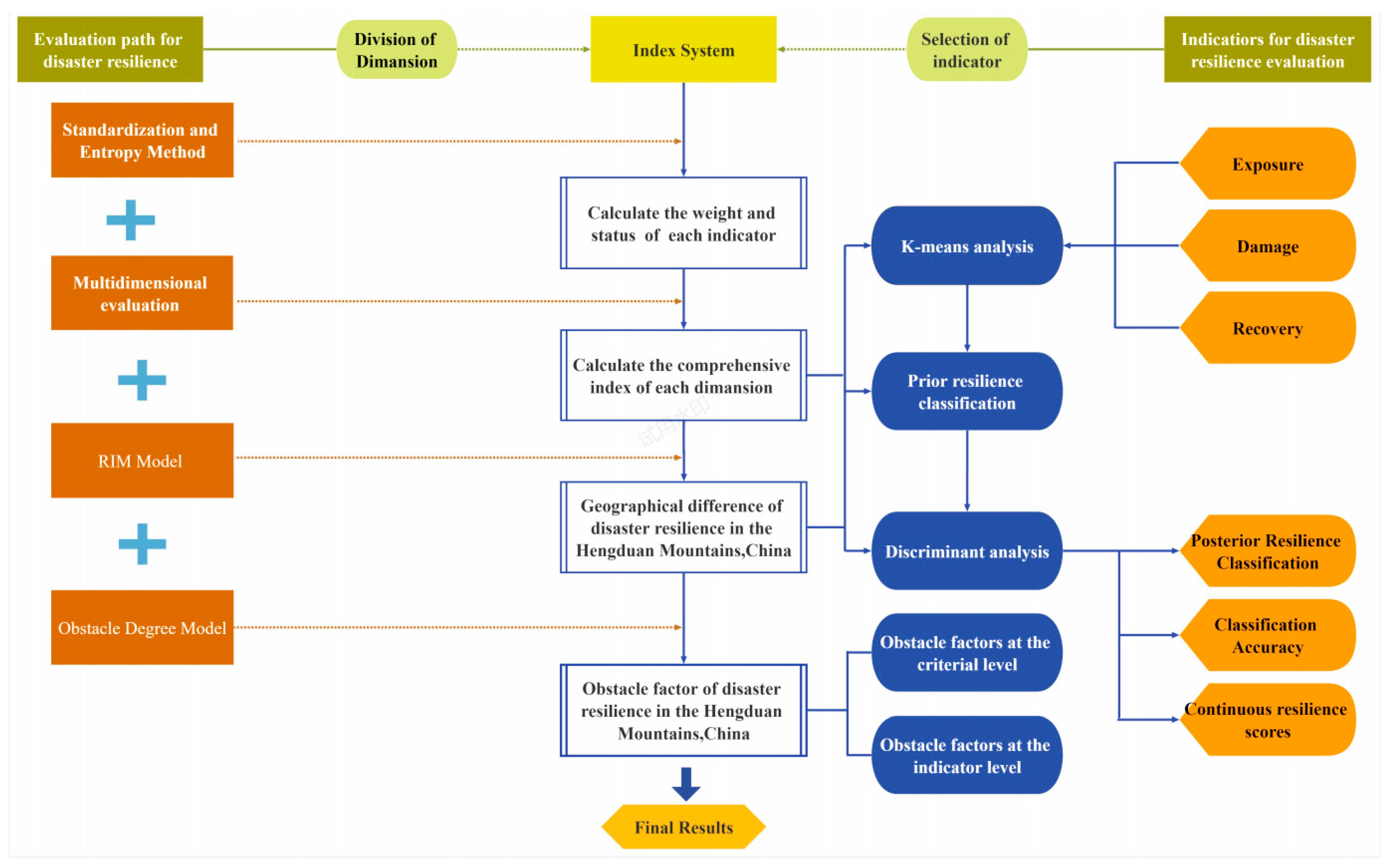
2. Materials and Methods

2.1. Study Area

In terms of administrative division, the Hengduan Mountain area mainly comprises Sichuan Province, Yunnan Province, and some districts and counties of the Tibet Autonomous Region [45]. The altitude decreases from northwest to southeast, with the highest altitude of 7713 m and the lowest of 76 m. The topology is dominated by inter-mountain basins, lakes, and ancient glacial erosion and deposition features, forming a geomorphology with high mountains and deep valleys and a great relative elevation difference [46]. Under the control of monsoon circulation and the influence of topography, the climate in the region varies greatly. According to the data from meteorological stations, the annual average rainfall in the region is as high as 1137 mm. Rainfall is mainly concentrated from May to October and mainly occurs as heavy, torrential, night, and topographic rain. In terms of the spatial distribution, rainfall is abundant in the south and northeast; however, it is lower in the north and west. Owing to the natural environment, the area is sparsely populated, transportation is difficult, and it has a relatively underdeveloped economy. Driven by earthquakes, extreme rainfall events, disturbance by human engineering activities, among other factors [47], geological disasters, such as debris flows, collapses, and landslides, frequently occur in the Hengduan Mountains [48], aggravating regional poverty and environmental deterioration, and severely restricting the economic and social development of this area.
Based on the ArcGIS platform, Xu et al. (2019) [49] built an index system based on two aspects of vulnerability and risk and provided a dynamic risk assessment of the Hengduan Mountain area every 5 years from 2000 to 2015. The results show that the northwest Hengduan Mountain area is large and sparsely populated, and industry and commerce are relatively underdeveloped; therefore, vulnerability is relatively low and the risk levels are medium to low. By contrast, the high- and extremely high-risk regions of the south and northeast are densely populated and economically active; therefore, their vulnerability levels are relatively high and the corresponding risk levels are also relatively high. As this region is constantly affected by disasters and is under great threat, how to effectively resist, absorb, accommodate, adapt, and transform the impact of disasters and how to actively recover from them and move towards sustainable development is a major challenge for disaster prevention and mitigation. In this paper, 65 counties (cities) located in the area at a high risk of geological disasters in the south and northeast of the Hengduan Mountains (Figure 1) were selected as case studies to evaluate their resilience in the face of high-risk geological disasters, explore the factors that affect resilience coping ability, and provide a scientific basis for regional effective response to natural disasters.
The Hengdian Mountain area with a high risk of geological disasters is mostly located in the southeast of the Qinghai–Tibet Plateau. The terrain is high in the northwest and low in the southeast, spanning 98° E~104° E and 25° N~32° N. The administrative region covers 26 counties (cities) of Sichuan Province and 39 counties (cities) of Yunnan Province, with a total land area of 193,000 km2 and a total population of 17.95 million. The local climate in the area is varied, the soil is relatively moderate and low, the plants and animals are diverse, and the land-use types are diverse. The mountainous terrain has a large relief degree and the ground is rugged. By 2021, the GDP of the region was CNY 7.23 million, with a low GDP output and relatively backward economy.

2.2. Methods and Data Collection

2.2.1. Data Collection

Annual precipitation data from 2015 to 2020 were obtained from NOAA (National Oceanic and Atmospheric Administration). Topographic relief data were retrieved from the grid data setdataset of Chinese land relief in kilometers calculated by Zhen You et al. using the digital elevation model (SRTM90m) [50]. Geological disaster data were derived from the spatial distribution data of geological disaster sites and field surveys. The social and economic data used in this paper, such as per- capita green area of parks, industrial structure, per- capita GDP, urban registered unemployment rate, population density, and per- capita urban disposable income, were derived from the 2021 Statistical Yearbook of Yunnan Province [51], Sichuan Statistical Yearbook [52], Sichuan Yearbook [53], Yunnan Yearbook [54], China County Statistical Yearbook [55], and China County Statistical Yearbook of Regional Construction [56], and the statistical bulletin of national economic and social development of counties (cities). The natural population growth rate, aging rate, working population ratio, female population ratio, and other data were derived from the main data bulletins of the seventh National Population Census of each county (city) (Table 1). Some missing data were averaged for completion.
Among them:
To   both   GDP = Gross   regional   product Area   of   region
This indicator reflects the degree of economic concentration in a region:
Investment   density   of   fixed   assets = Gross   fixed   asset   formation Area   of   region
This index reflects the exposure degree of a region in urban construction:
Fiscal   expenditure   ratio = General   public   budget   revenue General   public   budget   expenditures × 100 %
This indicator reflects a region’s level of local financial self-sufficiency.

2.2.2. Standardized Processing

Raw data can be divided into vector data and raster data. Due to the different dimensions and quantities of raw data, direct analysis with raw data will highlight the role of indicators with higher data in the comprehensive analysis, while weaken the role of indicators with lower values. Therefore, in order to make sure the reliability of the analysis results, it is necessary to standardize the original data of each index. In this paper, Z-score standardization is adopted to standardize the original data, and the data is scaled to make them fall into a specific interval. After standardization, the mean value of all features was 0 and the standard deviation was 1, avoiding the influence caused by different sizes of different dimensions.
Z ( x ) = ( X X ¯ ) / σ X
where, respectively, X, σX are the mean and standard deviation of the variable X.

2.2.3. Entropy Model

At present, there are many methods to determine index weights, which can be roughly divided into subjective weighting and objective weighting methods. The analytic hierarchy process (AHP) and expert scoring method are subjective weighting methods, and to some extent, they are subjective arbitrary. Therefore, this paper selected the entropy method of the objective weighting method to conduct data standardization according to the size value and influence of indicators, and then determined the weight of the disaster resilience index for the Hengduan Mountain geological disaster high-risk area, so as to eliminate the deviation caused by subjective human factors to a certain extent. Using the data entropy of the regional disaster resilience index, the weight vector was Wj = (W1, W2, …, Wn). The indicator weight was then calculated by:
W j =   d j / j = 1 m d j
d j   = 1 e j
e j   = ( 1 / ln n )   ×   i = 1 n P ij ln ( P ij )
where dj is the index information entropy; ej is the proportion of index value in the i year of the j indicator; n is the number of evaluation years; and m is the number of indicators [57].

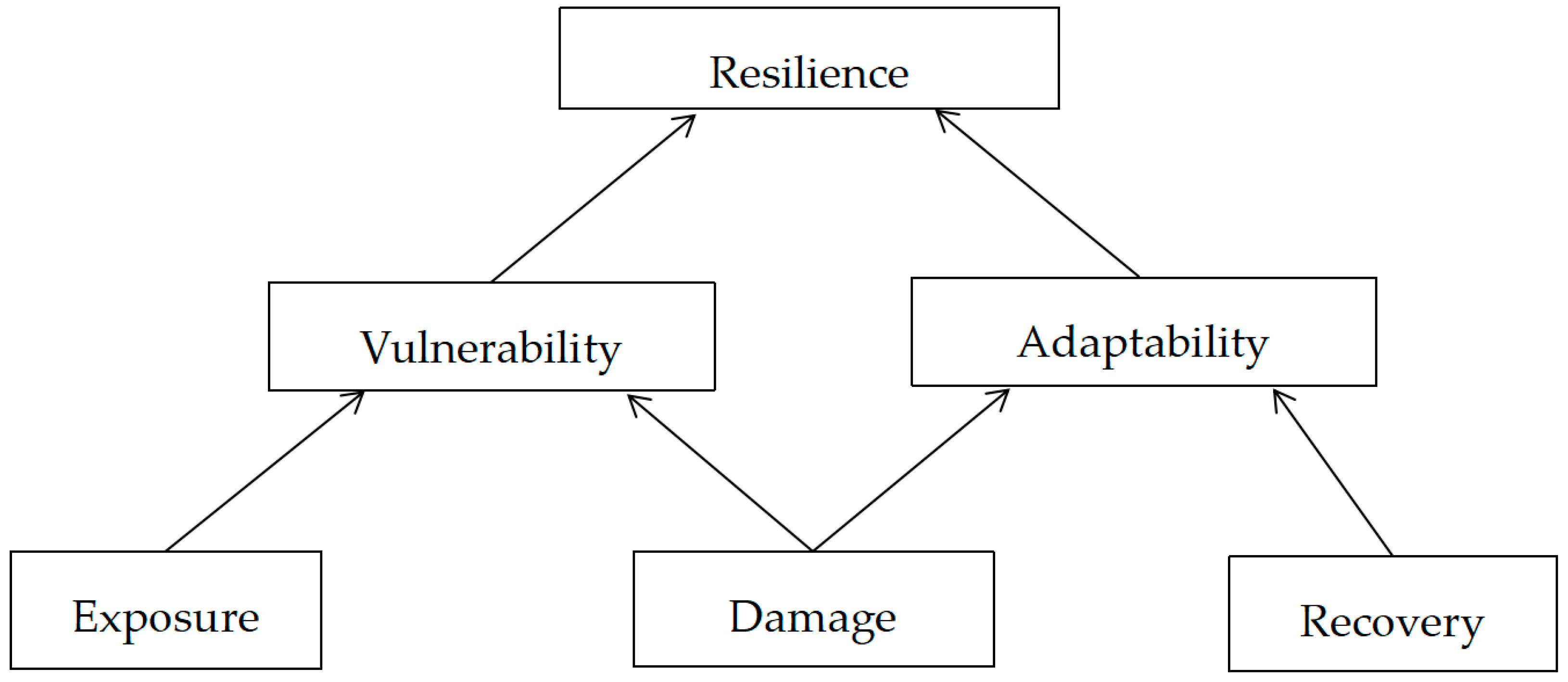
2.2.4. The Resilience Inference Measurement (RIM) Model

The RIM model is a method used to indirectly evaluate observed resilience and validate the selection of external and internal variables. The RIM model is evaluated based on vulnerability and adaptability. Vulnerability refers to the adverse impact of carrier exposure to disasters [58,59,60], while adaptability refers to the ability of a region to recover over time after disasters [59,60,61]. These two attributes can be measured by exposure (the number of times a region is exposed to disasters, such as geological disasters), damage (the losses suffered by a region, such as property losses and casualties), and recovery [60,62]. Vulnerability and adaptation are expressed as slopes between exposure and damage and between damage and recovery (Figure 2). From low to high, different regions are divided into four disaster resilience states: susceptible (with high vulnerability and low adaptability characteristics), recovering (with average vulnerability and adaptability characteristics), resistant (with low vulnerability and average adaptability characteristics), and usurper (with low vulnerability and high adaptability characteristics) in the RIM framework [60]. Vulnerability and adaptability indicate the relationship between exposure to damage and damage to recovery, respectively (Figure 3).
The application of the RIM model involves two statistical techniques: K-means cluster and discriminant analyses. (1) K-means cluster analysis is a prior classification method to determine the number of clusters, while (2) discriminant analysis is a method used to verify the relative importance of K-means clustering results and indicators.
The continuous disaster resilience of each region can be calculated using Equation (1):
DR = i m i × PR
where DR is the disaster resilience index, m is the number of disaster resilience groups in K-means clustering, i is the ranking of disaster resilience groups, and PR(i) represents the posterior probability of belonging to a particular disaster resilience group i.

2.2.5. Obstacle Degree Model

The main feature of the obstacle degree model is that it can calculate the obstacle degree of each evaluation index in the comprehensive evaluation, find out the key factors that restrict the further development of things, clarify the factors that have the main influence on the evaluation results, clarify the influence degree of the key constraints, and provide scientific basis for the formulation of scientific and reasonable policies. After calculating the continuous disaster resilience for the area at high risk of geological disasters in the Hengduan Mountain, the obstacle degree model was built to diagnose the main obstacle factors restricting the disaster resilience of this high-risk area. The specific calculation process is as follows:
O j = { 1 P j           P j 1 0         P j > 1  
V j = F j ×   O j j   = 1 65 F j × O j
where Pj is the standardized value of each index, Oj is the index deviation degree (i.e., the difference between the evaluation value of a single index and 100%), Fj is the factor contribution degree, and the optimal combination weight of the JTH index is adopted here, and Vj represents the obstacle degree index [63].

2.3. Index System Construction

2.3.1. Evaluation Index Construction

By referring to the existing research results at home and abroad [35,64,65], this paper comprehensively considered the local characteristics and development differences of Hengduan Mountain counties (cities) and the difficulty of data acquisition. Forty-one indexes were selected from four subsystems (economic, social, eco-, and infrastructure systems) and two aspects (vulnerability and adaptability) to evaluate the disaster resilience of the Hengduan Mountain geological disaster high-risk area (Table 2).

2.3.2. Index Weight Determination and Evaluation

First of all, this paper needed to conduct z-score standardized processing on the acquired original data. Then, in order to eliminate the deviation caused by subjective factors, this paper used the entropy method to determine the weight of the criterion and index layers. The combined weight was obtained by multiplying the weights of the criterion and index layers (Figure 4).

3. Results

3.1. Spatial Distribution of Disaster Resilience in High-Risk Areas for Hengduan Mountain Geological Hazards

The final clustering center values (Table 2) and spatial distribution of the four disaster resilience types were obtained by K-means clustering calculation (Figure 5a). The 65 counties (cities) were classified into four disaster resilience states from low to high, among which seven counties (cities), including Fumin county, Lushui city, and Fugong county, were classified as “Susceptible”. These counties (cities) were mainly distributed in the west and south, where infrastructure and the ecological environment were subject to a high level of exposure, and the damage degree of disasters was the highest following disasters. The final cluster center value of restoration was low, and following a geological disaster, it cannot be completely restored by itself. Miyi county, Huize county, Yongsheng county, and 25 other counties (cities) were clustered as “Recovering”. This type was mainly distributed in the northwest, center, and southeast, with lower-than-average exposure, damage, and recovery. After geological disasters, the unbalanced state is restored to an equilibrium state over time, and the recovery cycle is relatively long. Twenty-six counties (cities), including Renhe district, Shimian county, and Weixi county, were classified as “Resistant”, and these were mainly distributed in the central and northern regions. These counties (cities) only had low damage and recovered well, even after high exposure. Seven counties (cities), such as Dong district, Xichang city, and Dali city, were clustered as “Usurper”, and mainly distributed in the northeast and southwest. These counties (cities) can not only withstand disasters, but also have good prospects for sustainable development.
According to the results of the step-based discriminant analysis (Figure 5b), eight counties (cities) were classified as “Susceptible”, 23 as “Recovering”, 27 as “Resistant”, and seven as “Usurper”. Xundian county was classified as “Susceptible” to “Recovering”, Tianquan and Wuding counties as “Recovering” to “Resistant”, and Ninglang county as “Resistant” to “Recovering”. The classification accuracy of the discriminant analysis was 95.4%, indicating that the 41 indicators could be used to explain the disaster resilience of 65 counties (cities). Meanwhile, the average prediction results of 65 iterations showed that the accuracy of missed cross-validation was 93.4%, and the difference between classification and missed cross-validation accuracies was low, indicating that the RIM model was quite robust.
The four disaster resilience states were expressed as 1–4 in the discriminant analysis. Then, based on the probability of group members, the continuous disaster resilience scores of each county (city) were calculated via Equation (1). According to the data characteristics of the calculated results, the continuous disaster resilience scores were divided into five levels from high to low, expressed as high resilience (2.0–2.5), medium–high resilience (1.5–2.0), medium resilience (1.0–1.5), medium–low resilience (0.5–1.0), and low resilience (<0.5). The average continuous disaster resilience score for the 65 counties (cities) in high-risk areas was 0.942, which was at a low resilience level. Dong district had the highest continuous disaster resilience score (2.45), followed by Yao‘an county and Xi district (1.93 and 1.61, respectively), and Gongshan county had the lowest score (0.036). The highest continuous disaster resilience score was 68-times higher than the lowest value. There were significant differences among counties (cities), among which the counties (cities) with high resilience accounted for 3% of the total, and the medium–high resilience scores accounted for 9%. The number of counties (cities) with medium–high resilience, medium resilience, and medium–low resilience was significantly higher than that with high and low resilience levels, indicating that there was no obvious “polarization” phenomenon in the disaster resilience of the high-risk area. As can be seen from Figure 6, the spatial distribution of disaster resilience in the Hengduan Mountain area with a high risk of geological disasters is significant, showing a distribution pattern of “high in the southeast and low in the northwest”. Those counties (cities) with high and medium–high resilience levels showed a “spot-like” distribution pattern, mainly in the core areas with high population density and strong economic activity. The distribution pattern of medium-resilience counties (cities) was “clumpy”, mainly distributed in the central and southeastern regions. Those counties (cities) with medium–low and low resilience levels showed a “marginal extension” distribution pattern, mainly in the transition zone between the Qinghai–Tibet and Yunnan Plateaus.

3.2. Analysis of Obstacle Factors

3.2.1. Criterion Layer Obstacle Degree Analysis

According to the obstacle degree model, the obstacle degree of the disaster resilience criterion layer of the Hengduan Mountains high-risk area was calculated. According to these results (Figure 7), each subsystem has different obstacle degrees to disaster resilience of the high-risk area; however, the overall performance was: economic barriers (32%) > ecological barriers (31%) > social barriers (22%) > infrastructure barriers (15%). Economic strength was the most important factor affecting the spatial differentiation of disaster resilience of most counties (cities) in the Hengduan Mountains area at high risk of geological disasters, which restricted improvements to the disaster resilience of other subsystems, such as society, ecology, and infrastructure. The geography in the region limited the space for economic growth, resulting in a single level of industrial economic structure in the region, a small number of factories of a certain scale, a lack of industrial support in the face of uncertain disaster impacts, and poor ability to resist risks and recovery ability, which was not conducive to the improvement of disaster resilience. The main obstacle factor in the northeastern and western regions was infrastructure construction. Key infrastructure construction in the region was relatively short term, especially regarding investments in disaster prevention engineering and support facilities, disaster early warning systems, post and telecommunications, drainage pipes, and other facilities in the built-up area. Therefore, the region had a low-risk prevention ability, was vulnerable to disaster stress during a disaster, and was relatively limited in its ability to recover following a disaster. The normal operation of regional functions could not be guaranteed. The northern region was mainly affected by social factors. In this region, the natural population growth rate was low, the number of workers in tertiary industries was relatively small, and the number of women and the elderly was relatively high. This not only increased the financial burden of the government, but also made it vulnerable to the impact of disasters, and it lacked the main workforce needed for recovery after disasters. It hindered improving regional disaster resilience. The main obstacle factor in the northeast and northwest regions was the ecological environment. In this region, there are many mountains and few rivers, and there are many ravines and valleys. The natural environment is extremely complex and fragile, and the ecological environment carrying capacity is low.

3.2.2. Obstacle Degree Analysis of the Indicator Layer

The obstacle degree model was used to analyze the obstacle factors of disaster resilience in 65 counties (cities) at a high risk of geological disasters in the Hengduan Mountains, determine the resistance factors affecting disaster resilience, and select the top-five obstacle factors in each county (city) to explore the source of the improvement of disaster resilience in this high-risk region (Table 3).
In the region as a whole, the top-five disaster resilience barrier factors and occurrence numbers were, respectively, E4 appearing 23 times; S2 appearing 21 times; S8, S3, and E2 appearing 15 times each; S4 and D6 appearing 14 times each; and I2 and I5 appearing 13 times each (Table 3). Among them, topographic relief had the greatest obstacle degree to disaster resilience in the high-risk area and most counties (cities) were affected by it. Due to the particular natural geographical conditions of the Hengduan Mountain area, mountain barrier and undulating terrain were the key factors restricting the development of the social economy and population, resulting in poor transportation, a low degree of contact with the outside world, difficulty in population movement, and relatively slow development of social and economic activities, which, to a large extent, limited the improvement of disaster resilience. S2 and E2 belonged to the human–land relationship elements and were the most basic elements of regional development. For the Hengduan Mountains area at a high risk of geological disasters, excessive population growth will lead to the continuous expansion of the scale of built-up areas, resulting in the encroachment on and occupation of a large amount of cultivated land, and at the same time increased the burden for resources and the environment supporting capacity, which means that the human–land relationship will continue to suffer. Thus, the ecological space is disjointed and occupied, and the regional bearing capacity to geological disasters is constantly being reduced, which affects improvements to disaster resilience. Slow population growth will cause wastage and extensive land resources and will make the carrier overly exposed to disasters, which will have an adverse impact on disaster resilience. S3 and S4 belong to the vulnerable groups. They are relatively weak in terms of escape ability, emergency response ability, disaster resistance and relief ability, self-protection awareness, and other aspects in response to geological disasters, and are vulnerable to the impact of geological disasters. The increase in their numbers is not conducive to improving disaster resilience within the region. S8, D6, I2, and I5 belong to the construction of infrastructure and the level of regional industrialization. In the final analysis, they reflect the level of economic development. The higher the level of economic development, the higher the level of industrialization, the better the infrastructure construction, and the higher the disaster resilience of the high-risk area. Therefore, the main obstacle factors for disaster resilience in the 65 counties (cities) at high risk of geological disasters in the Hengduan Mountains can be summarized as three factors: economic development level, human–land relationship, and the natural environment.
From the perspective of the primary obstacle factors, the different counties (cities) can be divided into three types as follows. (1) Natural environment barrier type: the state of the natural environment in the counties (cities) with this obstacle type has a negative impact on improving disaster resilience. The natural environment in 40% of the counties (cities) is complex and fragile, with rugged mountains, closed inter-regional links, few available land resources, and poor production conditions, as well as underdeveloped infrastructure and poor transportation accessibility, which limit the space for economic growth in the area and are not conducive to improving disaster resilience. Among them, the most important obstacle factor is topographic relief, such as in Yongren and Midu counties. These counties (cities) need to adapt to local conditions, undertake the reasonable and effective development and utilization of resources, reduce the consumption of various resources, reduce the environmental damage caused by urbanization and other human activities, steadily promote the development of the overall regional economy, and improve the carrying capacity of the natural environment to geological disasters to improve disaster resilience. (2) Economic barrier type: in this obstacle-type region, the economic structure and urbanization rate are low, the industrial structure is characteristically single, and the degree of resource exploitation and utilization is not high, resulting in a lack of overall economic development in the region, which directly affects investments in infrastructure, basic social security, and improving the ecological environment. For example, Dong district, Renhe district, and Mianning county need to optimize the industrial structure and resource allocation, extend the industrial chain, improve the level of industry and the added value of products, and promote improvements to the overall regional economy. (3) Demographic barrier type: in this obstacle-type area, vulnerable groups, such as those younger than 14 years old, older than 65 years old, and the female population occupy a dominant position. A possible reason is that the area is relatively underdeveloped economically and prone to geological disasters. Poverty and a return to poverty are prominent due to disasters. The lack of basic mass resources for disaster prevention, mitigation, and relief is not only detrimental to the development of counties (cities), but also increases the burden on the government and is not conducive to improving disaster resilience. Examples include Butuo, Huaping, and Nanhua counties. On the one hand, such counties (cities) need to develop regional characteristics, improve the regional economy, create job opportunities, improve incentive mechanisms, and retain young and middle-aged labor forces. On the other hand, the government needs to actively create a cultural atmosphere for disaster prevention, resistance, reduction, and relief, and strengthen the knowledge and skills relating to disaster prevention through scientific and effective training exercises (Table 4).

4. Discussion

In the Section 4, we explored the findings of the study in depth and investigated the reasons for spatial patterns of risk and resilience in the Hengduan Mountain area. The distribution of risk and resilience in the Hengduan Mountain region was influenced by many factors, which are worthy of further exploration.
First, topographical relief plays a significant role in shaping the spatial patterns of risk and resilience. The rugged terrain and steep slopes of the north-west increase the risk of geological catastrophes. High altitudes and the challenging terrain increase the risk of landslides, rockfalls, and other disasters, reducing the resilience of these areas. In contrast, the relatively mild topography of the south-east offers more favorable conditions for enhancing resilience, because the region is less prone to geological risks. Second, the demographics also influence spatial patterns of risk and resilience. The resistant core is characterized by a densely populated population and strong economic activity. These regions have benefited from improved resource allocation, a robust infrastructure, and economic opportunities, improving their response and resilience. Skilled workers, easy access to basic services, and a high degree of social cohesion also contribute to overall resilience. In contrast, the transition zone between the Qinghai–Tibet and Yunnan Plateaus may face specific challenges, including low population density, limited economic development, and inadequate infrastructure, resulting in low levels of resilience in these areas. Third, spatial risk and resilience profiles are influenced by economic, ecological, social, and infrastructure factors. Economic obstacles, such as limited resources and income disparities, call into question the resilience of high-risk areas. The unequal distribution of wealth and resources can affect the preparation and resilience of communities. Ecological barriers also play an important role because areas where ecosystems are degraded are more susceptible to geological disasters. The protection and restoration of ecosystems can increase resilience through the provision of natural defenses. Social barriers relate to education, awareness and community involvement, and in areas with low levels of education and awareness, pre-disaster preparedness, and post-disaster responses may be weaker. In conclusion, our study provided invaluable information on spatial risk assessment and resilience in high-risk areas of the Hengduan Mountain region. By establishing a multi-dimensional evaluation index system and using the research in motion (RIM) model, we evaluated the disaster resilience of high-risk areas in the Hengduan Mountains and identified patterns of spatial risk and resilience. The results suggest the need for effective risk management strategies and targeted interventions to increase the resilience of high-risk sectors. This conclusion was consistent with the research conclusions determined by Bai et al. (2019) [66], Li and Zhai (2017) [35], Zhiming Feng et al. (2011) [67], and Chen et al. (2016) [68], indicating that the overall disaster resilience evaluation index system in this paper was reasonable.
Furthermore, the importance of conducting similar studies and considering other criteria cannot be overlooked. By incorporating other factors and indicators, future studies can more comprehensively assess risk and resilience, thereby providing more targeted recommendations and decisions for disaster risk management and sustainable development in the Hengduan Mountain region. Exploring the changes in space models under different conditions will contribute to a more in-depth understanding of the dynamic relationship between risk and resilience. This will not only benefit the Hengduan Mountain area, but will also provide valuable references for similar regions facing geological disasters and seeking to improve resilience.
In general, the resilience assessment of high-risk areas in the Hengduan Mountain region is important to reduce regional disaster risks and promote sustainable development. Our study enriched the research content in the field of disaster resilience, objectively and truly reflected the resilience level of the Hengduan Mountain geological disaster high-risk area, and provided a reference for the future research and disaster risk management policy intervention.

5. Conclusions

It is of great significance to evaluate the resilience of the Hengduan Mountain high-risk area for reducing regional disaster risks and promoting regional sustainable development. In this paper, 65 counties (cities) in the Hengduan Mountain were selected as the research objects, and the disaster resilience evaluation index system for the Hengduan Mountain high-risk area of geological disasters was constructed from four subsystems of economy, society, ecology, and infrastructure, as well as the two aspects of vulnerability and adaptability. The RIM model was used to analyze the regional resilience of the Hengduan Mountain high-risk area for geological disasters. Combined with the obstacle degree model, the obstacle factors affecting disaster resilience were analyzed, and the conclusions are as follows:
(1)
The four coupling coordination states showed that 27 counties (cities) were classified as “Resistant”, which showed reduced losses after the disaster and recovered well, even after a high level of exposure. A total of 23 counties (cities) were classified as “Recovering”, which showed that the exposure level was high before the disaster, the unbalanced state could not be rapidly changed to the equilibrium state after the disaster, and the recovery period was relatively long. Eight counties (cities) were classified as “Susceptible”, showing that the carrier suffered from a high level of exposure before the disaster and could not fully recover by itself after the disaster. Seven counties (cities) were grouped into “Usurper”, showing that they could not only withstand disasters, but also presented broad prospects for sustainable development. The classification accuracy rate was 95.4%, indicating that disaster resilience was composed of multi-element capability. The accuracy of missing cross-validation was 93.4%, which confirmed the robustness of the model.
(2)
The disaster resilience of 65 counties (cities) in the Hengduan Mountains with a high risk of geological disasters was evaluated, and the average score of continuous disaster resilience was 0.942, which was at a low resilience level. From the perspective of the number of counties (cities) with different disaster resilience levels, the number of counties (cities) with low resilience accounted for the majority, while the number of counties (cities) with high resilience accounted for a relatively small proportion, an “extreme” differentiation. From the perspective of spatial distribution, the distribution pattern was “high in the southeast and low in the northwest”. Those counties (cities) with high and medium–high resilience levels showed a “dot” distribution pattern, mainly distributed in the core areas with a gentle terrain, high population density, strong economic activity, complete infrastructure, and good ecological environment quality. The distribution pattern of medium resilience was “clumpy”, mainly distributed in the central and southeastern regions. Those counties (cities) with medium–low and low resilience levels showed a “marginal extension” pattern of distribution, mainly distributed in the transition zone between the Qinghai–Tibet and Yunnan Plateaus.
(3)
There were clear differences in the disaster resilience barrier degree of this high-risk area: criterion layer barrier degree, economic barrier degree > ecological barrier degree > social barrier degree > infrastructure barrier degree. From the perspective of the index layer obstacle degree, the main factors affecting the disaster resilience distribution in this high-risk area included topographic relief, proportion of female population, natural growth rate, cultivated land area, industrial structure, number of industrial enterprises above a designated size, gas penetration rate, and drainage pipe density in built-up areas, among others. In addition, according to the difference in the primary obstacle factors, the different regions can be classified into three types: natural environmental obstacle type, economic obstacle type, and population structure obstacle type.
There remain deficiencies in the study of disaster resilience. First, improving disaster resilience is affected by multiple factors. This paper only selected some indicators from economy, society, ecology, and infrastructure to evaluate the disaster resilience of the Hengduan Mountain area at high risk of geological disasters, and further explorations and optimizations are needed with regard to the selection of indicators and system construction. Secondly, this study evaluated the disaster resilience of this high-risk area only for 2015 and therefore does not provide a dynamic assessment of disaster resilience for a long time series. Finally, due to the limited availability of the disaster data, the lack of formal statistics on disaster data, and relevant disaster literacy, it was not possible to determine how and how strongly disaster shocks affect resilience during the assessment process. Therefore, how to construct an index system suitable for evaluating disaster resilience and how to conduct targeted empirical research on disaster resilience still need further in-depth research.

Author Contributions

H.G. conducted the research, analyzed the data, and wrote the paper; B.N., Z.Z. and S.Z. made suggestions for this paper; Q.Z. conceived the research and provided support for the project. All authors have read and agreed to the published version of the manuscript.

Funding

This research was funded by the Second Tibetan Plateau Scientific Expedition and Research (STEP) (Grant No. 2019QZKK0906-02).

Institutional Review Board Statement

Not applicable.

Informed Consent Statement

Not applicable.

Data Availability Statement

No new data were created or analyzed in this study. Data sharing is not applicable to this article.

Acknowledgments

In the process of writing this article, I have received the help of Zhou Yuantao and Gao Yuan from Qinghai Normal University. I would like to express my thanks to all.

Conflicts of Interest

The authors declare no conflict of interest.

References

  1. Lechat, M.F. The international decade for natural disaster reduction: Background and objectives. Disasters 1990, 14, 1–6. [Google Scholar] [CrossRef]
  2. The United Nations International Strategy for Disaster Reduction. Hyogo Framework for Action 2005–2015: Building the Resilience of Nations and Communities to Disasters; The United Nations International Strategy for Disaster Reduction: Geneva, Switzerland, 2005. [Google Scholar]
  3. United Nations Office for Disaster Risk Reduction (UNISDR). Sendai Framework for Disaster Risk Reduction 2015–2030. 2020. Available online: https://reliefweb.int/report/world/sendai-framework-disaster-risk-reduction-2015-2030-aconf224crp1?gclid=EAIaIQobChMI3YOZ_oby_wIVCYXCCh1GywfzEAAYASAAEgLJ-vD_BwE (accessed on 10 April 2023).
  4. Shi, P.; Jeager, C.; Qian, Y. Integrated Risk Governance: IHDP—Integrated Risk Governance Project Series; Beijing Normal University Press: Beijing, China, 2012. [Google Scholar]
  5. Cutter, S.L.; Barnes, L.; Berry, M.; Burton, C.; Evans, E.; Tate, E.; Webb, J. A place-based model for understanding community resilience to natural disasters. Glob. Environ. Chang. 2008, 18, 598–606. [Google Scholar] [CrossRef]
  6. Bruneau, M.; Chang, S.E.; Eguchi, R.T.; Lee, G.C.; O’Rourke, T.D.; Reinhorn, A.M.; Shinozuka, M.; Tierney, K.; Wallace, W.A.; Von Winterfeldt, D. A Framework to quantitatively assess and enhance the seismic resilience of communities. Earthq. Spectra 2003, 19, 733–752. [Google Scholar] [CrossRef]
  7. Shi, P. Disaster Risk Science; Beijing Normal University Press: Beijing, China, 2017. [Google Scholar]
  8. Manyena, S.B. Disaster resilience: A question of ‘multiple faces’ and ‘multiple spaces’? Int. J. Disaster Risk Reduct. 2014, 8, 1–9. [Google Scholar] [CrossRef]
  9. Holling, C.S. Resilience and stability of ecological systems. Annu. Rev. Ecol. Syst. 1973, 4, 1–23. [Google Scholar] [CrossRef]
  10. Wang, L.; Shi, Z.; Zhang, Y. Psychometric properties of the 10-item Connor Davidson Resilience Scale in Chinese earthquake victims. Psychiatry Clin. Neurosci. 2010, 64, 499–504. [Google Scholar] [CrossRef] [PubMed]
  11. Renschler, C.S.; Frazier, A.; Arendt, L.; Cimellaro, G.P.; Reinhorn, A.M.; Bruneau, M. Developing the ‘PEOPLES’ resilience framework for defining and measuring disaster resilience at the community scale. In Proceedings of the 9th US National and 10th Canadian Conference on Earthquake Engineering, Toronto, ON, Canada, 25 July 2010. [Google Scholar]
  12. Mileti, D.S. Disasters by Design: A Reassessment of Natural Hazards in the United States, Natural Hazards and Disasters; Joseph Henry Press: Washington, DC, USA, 1999; pp. 45–49. [Google Scholar]
  13. Zhai, C.; Liu, W.; Xie, L. Progress of research on city seismic resilience evaluation. J. Build. Struct. 2018, 39, 1–9. [Google Scholar]
  14. Wu, B.; Chen, A. Framework of the evaluation model resilient cities. Sci. Technol. Rev. 2018, 36, 94–99. [Google Scholar]
  15. Shao, Y.; Xu, J. Understanding urban resilience: A conceptual analysis based on integrated international literature review. Urban Probl. 2015, 30, 48–54. [Google Scholar]
  16. Wang, B.; Zhang, H.; Zhang, W. Definition, connotation and measurement of the concept of community resilience. Urban Probl. 2016, 6, 75–81. [Google Scholar]
  17. Fei, X.; Wen, J.; Du, S. Research progress of natural disaster resilience. J. Nat. Disasters 2014, 23, 19–31. (In Chinese) [Google Scholar]
  18. Cai, J.; Guo, H.; Wang, D. Review on the resilient city research overseas. Prog. Geogr. 2012, 31, 1245–1255. [Google Scholar]
  19. Jones, L.; Ballon, P. Tracking changes in resilience and recovery after natural hazards: Insights from a high-frequency mobile-phone panel survey. Glob. Environ. Chang. 2020, 62, 102053. [Google Scholar] [CrossRef]
  20. Paton, D.; Johnston, D. Disasters and communities: Vulnerability, resilience and preparedness. Disaster Prev. Manag. Int. J. 2001, 10, 270–277. [Google Scholar] [CrossRef]
  21. Li, X.C.; Yu, L.; Xu, Y.D. Ten years after Hurricane Katrina: Monitoring recovery in new orleans and the surrounding areas using remote sensing. Sci. Bull. 2016, 61, 1460–1470. [Google Scholar] [CrossRef]
  22. Cutter, S.L.; Burton, C.G.; Emrich, C.T. Disaster resilience indicators for benchmarking baseline conditions. J. Homel. Secur. Emerg. Manag. 2010, 7, 1–22. [Google Scholar] [CrossRef]
  23. Ahmed, S. The resilience dividend: Being strong in a world where things go wrong. In Resilience International Policies Practices and Discourses; Public Affairs: New York, NY, USA, 2014. [Google Scholar] [CrossRef]
  24. Susi, M. Resilience in the Face of Global Environmental Change; Community and Regional Resilience Initiative: Oak Ridge, CA, USA, 2008. [Google Scholar]
  25. Susan, L.C.; Lindsey, B.; Melissa, B. Community and Regional Resilience: Perspectives from Hazards, Disasters and Emergency Management; Community and Regional Resilience Initiative: Oak Ridge, CA, USA, 2008. [Google Scholar]
  26. Betty, H.M. Community Resilience: A Social Justice Perspective; Community and Regional Resilience Initiative: Oak Ridge, CA, USA, 2008. [Google Scholar]
  27. Shaw, R.; Razafindrab, B. Climate Disaster Resilience: Focus on Coastal Urban Cities in Asia. Asian J. Environ. Disaster Manag. 2009, 1, 101–116. [Google Scholar]
  28. Thomas, T.; Mitchell, T.; Polack, E. Urban Governance for Adaptation: Assessing Climate Change Resilience in Ten Asian Cities; The Institute of Development Studies at the University of Sussex: Brighton, UK, 2009; pp. 34–36. [Google Scholar]
  29. Qasim, S.; Qasim, M.; Prasad Shrest-ha, R. Community resilience to flood hazards in Khyber Pukhthunkhwa province of Pakistan. Int. J. Disaster Risk Reduct. 2016, 18, 100–106. [Google Scholar] [CrossRef]
  30. Yang, M.; Huang, B.; Cui, C. Review and prospect of disaster prevention research based on resilient city theory. Urban Plan. Forum 2016, 1, 48–55. [Google Scholar]
  31. Liu, J.; Shi, P.; Ge, Y.; Wang, J.; Lu, H. Review on research progress of disaster resilience. Adv. Earth Sci. 2006, 2, 211–218. [Google Scholar]
  32. Yan, J. Assessment of Agricultural Economic Resilience after Flood Disaster—A Case Study of Dongting Lake Region; Hunan University of Science and Technology: Xiangtan, China, 2012. [Google Scholar]
  33. Chen, Y. Study on Evaluation of Flood Resilience in Sichuan Province; Chongqing Normal University: Chongqing, China, 2012. [Google Scholar]
  34. Jin, S. Study on Earthquake Disaster Risk and Resilience of Urban Water Supply System; Harbin Institute of Technology: Harbin, China, 2014. [Google Scholar]
  35. Li, Y.; Zhai, G. Urban disaster resilience assessment and improvement strategies. Planners 2017, 33, 5–11. (In Chinese) [Google Scholar]
  36. Cutter, S.L. The landscape of disaster resilience indicators in the USA. Nat. Hazards 2016, 80, 741–758. [Google Scholar] [CrossRef]
  37. Sharifi, A. A critical review of selected tools for assessing community resilience. Ecol. Indic. 2016, 69, 629–647. [Google Scholar] [CrossRef]
  38. Asadzadeh, A.; Kötter, T.; Zebardast, E. An augmented approach for measurement of disaster resilience using connective factor analysis and analytic network process (F’ANP) model. Int. J. Disaster Risk Reduct. 2015, 14, 504–518. [Google Scholar] [CrossRef]
  39. Kusumastuti, R.D.; Husodo, Z.A.; Suardi, L.; Danarsari, D.N. Developing a resilience index towards natural disasters in Indonesia. Int. J. Disaster Risk Reduct. 2014, 10, 327–340. [Google Scholar] [CrossRef]
  40. Miles, S.; Chang, S. Resilience: A community based disaster resilience model. Cartogr. Geogr. Inf. Sci. 2011, 38, 36–51. [Google Scholar] [CrossRef]
  41. Rose, A. Economic resilience to natural and man-made disasters: Multidisciplinary origins and contextual dimensions. Glob. Environ. Chang. B Environ. Hazards 2007, 7, 383–398. [Google Scholar] [CrossRef]
  42. Francis, R.; Bekera, B. A metric and frameworks for resilience analysis of engineered and infrastructure systems. Reliab. Eng. Syst. Saf. 2014, 121, 90–103. [Google Scholar] [CrossRef]
  43. Feofilovs, M.; Romagnoli, F. Dynamic assessment of urban resilience to natural hazards. Int. J. Disaster Risk Reduct. 2021, 62, 102328. [Google Scholar] [CrossRef]
  44. Sen, M.; Dutta, S.; Kabir, G. Modelling and quantification of time-varying flood resilience for housing infrastructure using dynamic Bayesian network. J. Clean. Prod. 2022, 361, 132266. [Google Scholar] [CrossRef]
  45. Shi, Z.; Deng, W.; Zhang, S. Spatial pattern and spatial-temporal change of Hengduan Mountain Area in recent 25 years. Geogr. Res. 2018, 37, 607–621. [Google Scholar]
  46. Xu, R.; Li, X.; Hu, K. Dynamic risk assessment of mountain disasters in Hengduan Mountain Area. J. Catastrophol. 2019, 34, 196–201, 208. [Google Scholar]
  47. Bian, J.; Li, X.; Hu, K. Regional distribution characteristics and dynamic evolution law of mountain hazards in Hengduan Mountain Area. In Proceedings of the 2018 National Engineering Geology Annual Conference, Beijing, China, 12–16 October 2018; pp. 15–22. [Google Scholar]
  48. Mao, G.; Hu, Y.; Chen, Y. Exploration on settlement safety in mountainous area with frequent geological disasters: A case study of market towns and villages in Hengduan Mountain System. J. Xi’an Univ. Archit. Technol. (Nat. Sci. Ed.) 2014, 46, 101–108. [Google Scholar] [CrossRef]
  49. Xu, R.; Li, X.; Hu, K.; Nie, Y.; Bian, J. Dynamic risk assessment of mountain hazards in Hengduan Mountain Area. J. Mt. Sci. 2020, 38, 222–230. [Google Scholar]
  50. You, Z.; Feng, Z.; Yang, Y. China relief degree of km grid data set [DB/OL]. Glob. Chang. Data Storage 2018, 1, 5. [Google Scholar] [CrossRef]
  51. Yunnan Provincial Bureau of Statistics. Yunnan Statistical Yearbook; China Statistics Press: Beijing, China, 2021; p. 11. [Google Scholar]
  52. Sichuan Provincial Bureau of Statistics. Sichuan Statistical Yearbook; China Statistics Press: Beijing, China, 2021; p. 10. [Google Scholar]
  53. Director of the General Office of Sichuan Provincial People’s Government, Sichuan Provincial Local Chronicles Work Office. Sichuan Yearbook; Sichuan Yearbook Society: Chengdu, China, 2021; p. 12.
  54. People of Yunnan Province, Office of Yunnan Provincial Local Chronicles Compilation Committee. Yunnan Yearbook; Yunnan Yearbook Society: Kunming, China, 2021; p. 11. [Google Scholar]
  55. Department of Rural Socioeconomic Survey, National Bureau of Statistics. China County Statistical Yearbook; China Statistics Press: Beijing, China, 2022; p. 2.
  56. Ministry of Housing and Urban-Rural Development of the People’s Republic of China. China County Construction Statistical Yearbook; China Statistics Press: Beijing, China, 2021; p. 9.
  57. Nikkhah, A.; Firouzi, S.; Ei Haj Assad, M.; Ghnimi, S. Application of analytic hierarchy process to develop a weighting scheme for life cycle assessment of agricultural production. Sci. Total Environ. 2019, 665, 538–545. [Google Scholar] [CrossRef]
  58. Folk, C.; Carpenter, S.; Elmqvist, T.; Gunderson, L.; Holling, C.S.; Walker, B.; Bengtsson, J.; Berkes, K.; Colding, J.; Danell, K.; et al. Resilience and Development: Building Adaptive Capacity in a World of Transformations; ICSU Series on Science for Sustainable Development: Resilience and Sustainable Development; International Council for Science: Stockholm, Sweden, 2002. [Google Scholar]
  59. Norris, F.H.; Stevens, S.P.; Pfefferbaum, B.; Wyche, K.F.; Pfefferbaum, R.L. Community resilience as a metaphor, theory, set of capacities, and strategy for disaster readiness. Am. J. Community Psychol. 2008, 41, 127–150. [Google Scholar] [CrossRef]
  60. Lam, N.S.N.; Reams, M.; Li, K.; Li, C.; Mata, L.P. Measuring community resilience to coastal hazards along the Northern Gulf of Mexico. Nat. Hazards Rev. 2015, 17, 04015013. [Google Scholar] [CrossRef]
  61. Brooks, N.; Adger, W.N.; Kelly, P.M. The determinants of vulnerability and adaptive capacity at the national level and the implications for adaptation. Glob. Environ. Chang. 2005, 15, 151–163. [Google Scholar] [CrossRef]
  62. Li, K. Temporal Changes of Coastal Community Resilience in the Gulf of Mexico Region; Louisiana State University: Baton Rouge, LA, USA, 2011. [Google Scholar]
  63. Wang, C.; Long, Z.; Fan, R. Adaptation evaluation and obstacle factors analysis of rural production space system in Jiangjin District of Chongqing. Geogr. Res. 2019, 39, 1609–1624. [Google Scholar]
  64. Cutter, S.L.; Ash, K.D.; Emrich, C.T. The geographies of community disaster resilience. Glob. Environ. Chang. 2014, 29, 65–77. [Google Scholar] [CrossRef]
  65. Li, X.; Lam, N.; Qiang, Y.; Li, K.; Yin, L.; Liu, S.; Zheng, W. Measuring county resilience after the 2008 Wenchuan Earthquake. Int. J. Disaster Risk Sci. 2016, 7, 393–412. [Google Scholar] [CrossRef]
  66. Bai, L.; Xiu, C.; Feng, X.; Mei, D.; Wei, Y. Comprehensive assessment of urban resilience in China and its spatial-temporal differentiation. World Geogr. Stud. 2019, 28, 77–87. (In Chinese) [Google Scholar]
  67. Feng, Z.; Zhang, D.; Yang, Y. China points county relief degree and its correlation with population distribution and economic development. J. Jilin Univ. J. Soc. Sci. 2011, 1, 146–151, 160. [Google Scholar] [CrossRef]
  68. Chen, T.; Peng, L.; Liu, S.; Wang, X.; Xu, D. The relationship between topographic relief and population and economy in Hengduan Mountain based on GIS. J. Univ. Chin. Acad. Sci. 2016, 33, 505–512. [Google Scholar]
Figure 1. Counties (cities) examined in this study.
Sustainability 15 16111 g001
Figure 2. Four disaster resilience states in the RIM framework. The y-axis shows deviations in exposure, damage, and recovery from their means redrawing from [60,62].
Sustainability 15 16111 g002
Figure 3. The conceptual framework of the disaster resilience inference measurement (RIM) model redrawing from [60,62].
Sustainability 15 16111 g003
Figure 4. Study workflow showing key steps in the evaluation of disaster resilience.
Sustainability 15 16111 g004
Figure 5. Disaster resilience classification from K-means clustering (a) and discriminant analysis (b).
Sustainability 15 16111 g005
Figure 6. Spatial distribution of disaster resilience in the Hengduan Mountains high-risk area.
Sustainability 15 16111 g006
Figure 7. Barrier types of the disaster resilience criterion layer in the Hengduan Mountains geological disaster high-risk area.
Sustainability 15 16111 g007
Table 1. Data source table.
NameData SourceData TypeYear
Annual precipitationNational Oceanic and Atmospheric AdministrationVector Data2015~2020
Degree of reliefGrid dataset of Chinese land relief in kilometers calculated by Zhen You et al. using the digital elevation model (SRTM90m) [50]Vector Data2018
Administrative area, registered population, personnel in the secondary industry, personnel in the tertiary industry, gross regional product, general public budget revenue, general public budget expenditures, household savings deposits, number of industrial enterprises above a designated size, fixed-line subscribers, number of regular middle-school students, number of beds in medical and health institutions, number of social welfare institutionsStatistical Yearbook of Yunnan Province [51],
Statistical Yearbook of Sichu Province [52],
Sichuan Yearbook [53], Yunnan Yearbook [54], China County Statistical Yearbook [55]
Vector Data2021
Population density, road density, cultivated area, living area of urban residents, daily domestic water consumption per capita, penetration rate of gas, density of water supply pipelines in built-up area, green-covered area as a percentage of built-up area, road surface area per capita, garden green area, area of park green land per capita, ratio of water treated centrally, harmless disposal rate of household garbageChina County Statistical Yearbook of Regional Construction [56]Vector Data2021
Frequency of natural disasters, threat to property, damage to the house, damaged roads, threats to the populationField Survey ResearchVector Data2020
Natural population growth rate, aging rate, working population proportion, female population proportionMain data bulletins of the seventh National Population Census of each county (city)Vector Data2020
Table 2. Weight of evaluation indicators.
System LayerDimensionCriterion LayerIndicator LayerWeightCombination Weight
Disaster ResilienceEcological Resilience (0.116)ExposureE1 Proportion of built-up area to land area (%) (+)0.2290.027
E2 Cultivated area (m2) (+)0.1890.022
E3 Annual precipitation (mm) (−)0.0430.005
E4 Degree of relief (°) (−)0.0760.009
RecoveryE5 Area of park green land per capita (person/m2) (+)0.1110.013
E6 Garden green area (m2) (+)0.2160.025
E7 Green-covered area as a percentage of built-up area (%) (+)0.0450.005
E8 Ratio of water treated centrally (%) (+)0.0350.004
E9 Harmless disposal rate of household garbage (%) (+)0.0150.002
DamageE10 Frequency of natural disasters (number) (−)0.0410.005
Economic Resilience (0.465)ExposureD1 GDP per capita (CNY 104/
person) (+)
0.0890.041
D2 To both GDP (CNY 104/km2) (+)0.3140.146
D3 Fixed asset investment density (CNY 104/km2) (+)0.2450.114
D4 Urbanization rate (%) (+)0.0320.015
RecoveryD5 Fiscal expenditure ratio (%) (+)0.1460.068
D6 Industry structure (%) (+)0.0160.007
D7 Savings deposits per capita (CNY/person) (+)0.0820.038
D8 Number of industrial enterprises above a designated size (number) (+)0.0650.030
DamageD9 Threat to property (CNY 104) (−)0.0040.002
D10 Damage to the house (number) (−)0.0070.003
Infrastructure Resilience (0.179)ExposureI1 Density of highways (km/km2) (+)0.1370.025
I2 Density of water supply pipelines in built-up area (km/km2) (+)0.0550.010
I3 Living area of urban residents per capita (m2/person) (+)0.0580.010
I4 Daily domestic water consumption per capita (L) (−)0.0170.003
I5 Penetration rate of gas (%) (+)0.0650.012
RecoveryI6 Number of beds in health institutions per 1000 people (number) (+)0.1600.029
I7 Number of social welfare institutions (number) (+)0.1330.024
I8 Fixed-line subscribers (number)0.3080.055
I9 Road surface area per capita (m2/person) (+)0.0600.011
DamageI10 Damaged roads (km) (−)0.0070.001
Social Resilience (0.240)ExposureS1 Population density (person/km2) (−)0.0110.003
S2 Natural population growth rate (‰) (–)0.0560.013
S3 Female population proportion (%) (−)0.1040.025
S4 Aging rate (%) (−)0.0310.007
S5 Urban registered unemployment rate (%) (−)0.0130.003
RecoveryS6 Proportion of labor force (%) (+)0.050.012
S7 Urban disposable income per capita (CNY/person) (+)0.0220.005
S8 Proportion of employees in tertiary industries (%) (+)0.1140.027
S9 Number of health technicians per 1000 people (number) (+)0.2830.068
S10 Number of regular secondary school students per 1000 people (number) (+)0.280.067
DamageS11 Threats to the population (104 person) (−)0.0360.009
Note: (1) Systems are represented by the first letter of the English alphabet and economic systems are represented by D for disaster resilience; (2) “+” represents a positive indicator and “−” represents a negative indicator.
Table 3. Z-scores of final clustering center values of the four disaster resilience states the three dimensions.
SusceptibleRecoveringResistantUsurper
Exposure−0.07−0.160.110.25
Damage1.22−0.47−0.13−0.24
Recovery−0.19−0.140.211.15
Table 4. Top-five obstacle factors of disaster resilience in the Hengduan Mountains geological disaster high-risk area.
AreaObstacle Factor RankingAreaObstacle Factor Ranking
1234512345
MiyiD6E3I2I9I1WudingI3I2E4S2S11
YanbianD6I2S11E3S3LufengE4S3S5D9I10
ShimianI5E2E10I1S11XiangyunE4I5S2E10I2
TianquanI2E2S3I3I1BinchuanD6S2S8E4D10
BaoxingE9E2I3E6I1MiduE4I5S2D10I3
LudingE9E2I3E6I1YongpingI5S8I4S2D8
YanyuanD6I5E3S3E7YunlongE10S8S11I3E1
DechangE10I4I1S9S11EryuanS8S2D8D8D1
HuiliE10I1D6E4D10JianchuanE10S8I3E6D8
HuidongE7I2E10E6S3HeqingI4D6S2D10D8
NingnanE7S5E5I5E6FugongS7E2D4E5S5
PugeE7S6S4E6I9Xi DistrictS2D6E3E2E4
ButuoS6E8S4E7E6Dong DistrictE3E2E4S2D10
JinyangS6S4I9I4I2Renhe D6E1E10E4E3
ZhaojueS6S5S4I2E10Gucheng E2I7S4S8S9
XideE8S6S7S4E7Dongchuan I7S8E2E3I10
MianningD6I1S6E8S2Shangri-laE3S3E1S4S2
YuexiS6I4I5S4I2DaliE3S11E2D10E4
GanluoE8S4E5I5I9LushuiS3S7S5S4E1
MeiguE7S6E5S5S4XichangS5E7E8I9E10
LeiboE8E7I2I3S6ChuxiongS2E4E3I10D9
FuminS3I4E4I7E2EbianI5I9I2E2D6
SongmingE4S11S4E10D10YangbiI5D4E10I2S8
HuizeS3D4E4D7S6NanjianS8I5E4E6S2
QiaojiaS3I5S7S11D8YulongI4D4S11D8S3
YongshengS8S2E5D6S7NinglangS7S8E7S4I9
HuapingS6D4S8D6E4WeixiS3D4D8E2E3
MoudingE4D6S2I4S11LuquanS8D4S10I2S2
NanhuaS6E4S2S5I8XundianE4D4D1S8D7
YaoanE4S1E6I4E2WeishanI5I4S8S2S11
DayaoS2D6S5E4I8GongshanS7S3I4E2S4
YongrenE4S3I3D10S2LanpingS5D8S7S3D4
YuanmouE4D7S2I3S5
Disclaimer/Publisher’s Note: The statements, opinions and data contained in all publications are solely those of the individual author(s) and contributor(s) and not of MDPI and/or the editor(s). MDPI and/or the editor(s) disclaim responsibility for any injury to people or property resulting from any ideas, methods, instructions or products referred to in the content.

