Article

Bridging National Policies with Practical Rural Construction and Development: Research on a Decision Support System Based on Multi-Source Big Data and Integrated Algorithms

1
China Architecture Design and Research Group, Beijing 100044, China
2
School of Construct Management and Real Estate, Chongqing University, Chongqing 400044, China
3
School of Management Science and Engineering, Guizhou University of Finance and Economics, Guiyang 550025, China
*
Author to whom correspondence should be addressed.
Sustainability 2023, 15(23), 16152; https://doi.org/10.3390/su152316152
Submission received: 22 September 2023 / Revised: 9 November 2023 / Accepted: 10 November 2023 / Published: 21 November 2023

Abstract

:
While national policies play a crucial role in shaping local development, effective governance is essential for rural revitalization. However, the successful implementation and impact of these policies in rural areas can vary due to unique local circumstances, limited information, and a lack of sophisticated decision making tools. Closing the divide between overarching national policies and practical rural development is an immediate necessity. This study begins by creating a comprehensive five-dimensional evaluation system encompassing industrial economy, public utilities, transportation and logistics, policy and institutions, and resources and the environment. It then summarizes four typical development modes—the suburban fusion mode, the characteristic industry-oriented mode, the humanistic and ecological resource-based mode, and the balanced development mode with less distinct characteristics—through an analysis of the Chinese government’s policy framework for rural construction. Subsequently, it introduces a decision support system for rural construction and development founded on multi-source heterogeneous big data and integrated algorithms. This system was tested using 782 townships as samples for classification, evaluation, and decision support. The results leverages insights into current rural development trends to efficiently align with national policies and provide customized implementation recommendations tailored to local resource characteristics. This contributes to the practical execution of rural revitalization strategies and the advancement of scientific rural decision making.

1. Introduction

According to United Nations data, approximately 43% of the world’s population resides in rural areas. The “San Nong” (agriculture, rural areas, and farmers) issue is fundamentally related to national economy and people’s livelihoods. For a long time, the problem of imbalanced urban–rural development and inadequate rural development has been particularly prominent in developing and impoverished countries, seriously impeding the progress of global sustainable development [1].
China, as the world’s largest developing country, has a rural population that accounts for over 30% of its total population, making rural development a top priority for domestic progress. Since the founding of the People’s Republic of China 70 years ago, the country has undergone the largest and fastest urbanization process in world history, resulting in ongoing transformations and reconstructions of rural–urban relationships and development models [2]. Since 2004, the Chinese government has issued the Central Document, focusing on the agricultural and rural sectors for 18 consecutive years. In 2017, the Chinese government made a clear and deliberate commitment to advance the modernization of agriculture and rural areas through the concept of “urban-rural integration.” Then, in September 2018, they officially released the “Rural Revitalization Strategic Plan (2018–2022),” signifying the commencement of a fresh phase in rural revitalization efforts. Afterwards, national policies provided extensive guidance on various construction fields such as spatial planning, industrial development, infrastructure construction, land use, and institutional reformation. Most studies have taken the view that Chinese governments have played a leading positive role in rural development, highlighting the top–down driving effect, and given full play to its political advantages in theory, institutions, and practice [3], especially in areas such as environmental protection, infrastructure construction, and poverty reduction [4,5,6].
While national policies play a crucial role in shaping local development, effective governance is essential for rural revitalization. However, the successful implementation and impact of these policies in rural areas can vary due to unique local circumstances, limited information, and a lack of sophisticated decision making tools. This often results in unclear self-awareness among most communities regarding their unique characteristics and development patterns. Local decision-making has traditionally relied on subjective experiences, leading to inefficiencies and a failure to effectively realize policy objectives, thus creating a policy–practice gap [7]. There is an urgent need for a decision making method and tools that can align with national policies while effectively considering local conditions, and also involve targeted development and construction policy implementation.
Theoretical groundwork for rural policy formulation relies on creating a robust evaluation system and a development model [8]. Abundant researches have already been conducted on a rural construction and development evaluation index system, including the rural revitalization index, rural sustainability index, and agricultural and rural modernization evaluation index [9,10,11]. Many studies consider both physical aspects like rural resources, living conditions, ecology, and infrastructure, as well as intangible factors including the economy, society, culture, and institutions, from a construction element perspective [12,13,14,15,16]. There are also studies that approach from the perspective of breaking the urban–rural binary structure. They argue that rural areas should not solely depend on external factors like resource, capital and technology from urbanization, industrialization, and regional policies. Instead, they emphasize the importance of strengthening internal factors such as social governance capacity, sociocultural vitality, indigenous knowledge, and local cultural awareness for comprehensive rural development [17,18,19]. However, the existing research involves too many evaluation indicators, has not yet formed a unified standard, and lacks systematic studies that are guided by national policies to establish a comprehensive rural town evaluation indicator system [10].
In the context of development modes, research on village and town typology draws from geography, sociology, economics, and interdisciplinary perspectives. These studies classify villages and towns based on factors like scale, location distribution, morphology, land use, and social structure [20,21,22,23]. Existing research primarily relies on academic analysis, which lacks direct practical guidance for rural development, while policy-driven categorizations often offer clearer direction for rural town development. From China’s issued policies, the “Strategic Plan for Rural Revitalization (2018–2022)” has provided classified village development strategies with four typical modes: upgrading villages, characteristic protection villages, suburban fusion villages, and evacuation and relocation villages. However, this existing typology does not apply to higher-level township units, especially those in the evacuation and relocation mode [24]. Provincial and municipal governments have been formulating provincial land use spatial planning guidelines based on their own circumstances. For example, in Hebei Province, towns are categorized into five modes: the suburban service-oriented mode, the industry-driven mode, the characteristic preservation mode, the resource and ecology-oriented mode, and the modern agriculture-oriented mode [25]. In Hunan Province, towns are classified into seven types: the suburban service-oriented mode, the industrial development-oriented mode, the commercial and logistics-oriented mode, the modern agriculture-oriented mode, the cultural and tourism integration-oriented mode, the ecological protection-oriented mode, and other distinctive modes [26]. In Guizhou Province, towns are divided into seven types: the transportation hub-oriented mode, the tourism service-oriented mode, the green industry-oriented mode, the industrial and mining park-oriented mode, the commercial and distribution-oriented mode, the immigrant settlement-oriented mode, and other distinctive modes [27]. It can be seen that these existing typologies of rural development mode revolve around urban–rural relationships, village and town functions, and the preservation–development balance, and consider less distinct rural towns. However, they still have certain regional characteristics and cannot be generalized nationwide.
In terms of data and technology, the integration of big data and artificial intelligence with experiential decision making has become a significant agenda in government reforms and governance. Decision support systems (DSS) is a computer technology that provides support to decision-makers in complex decision making problems through the use of big data, intelligent models, and computerized knowledge bases [28,29]. Compared to subjective experiential decision-making, DSS excel in problem identification and definition, solution design, performance evaluation, and knowledge borrowing, thus enhancing the effectiveness of decision making [29]. In the context of rural development, research and practical applications related to decision support are primarily focused on specific areas such as agricultural production [30,31], medical diagnosis [32] and rural land planning [33,34], providing relatively mature technologies and methods for decision making in village and town construction, and development strategy formulation.
In this context, this study proposes a decision support system for rural construction and development based on multi-source heterogeneous big data and integrated algorithms on the basis of a content analysis of the Chinese government’s policy framework regarding village and town development, and uses 782 townships as test samples for classification, assessment, and decision support. The research methodology consists of four main components: a theoretical framework, system architecture design, empirical study, and result analysis with policy recommendations (Figure 1).
The specific research contents include the following:
(1)
Building upon a combination of a literature review and analysis of policy text related to rural development issued by the Chinese government, a development evaluation system and four typical rural development modes and are summarized. This provides the theoretical foundation for the decision support system;
(2)
The architecture of the system is proposed, which includes a database module and an algorithm library module built on multi-source heterogeneous big data and integrated algorithms;
(3)
The system is tested based on a dataset of 782 typical Chinese townships. The system’s output in village and town evaluation and development strategies is reported and verified;
(4)
Empirical findings are analyzed thoroughly, rural construction characteristics and development strategies are summarized, policy recommendations are crafted, and the study’s contributions and limitations are discussed.
We believe the main contribution of this study lies in the construction of a comprehensive rural development evaluation system via an identification of the major domains and sub-domains in China’s rural revitalization key policies. This system incorporates both internal and external factors, encompassing both soft and hard environmental elements that reveal key indicators of rural development in contemporary China. On this basis, we integrate diverse data sources with various decision making algorithms to provide an efficient and precise method for the holistic decision making process of rural construction and development. This approach offers classification and implementation recommendations that are aligned with national policies and tailored to local resources. These efforts significantly contribute to the practical execution of rural revitalization strategies and the advancement of scientific decision making in rural areas.

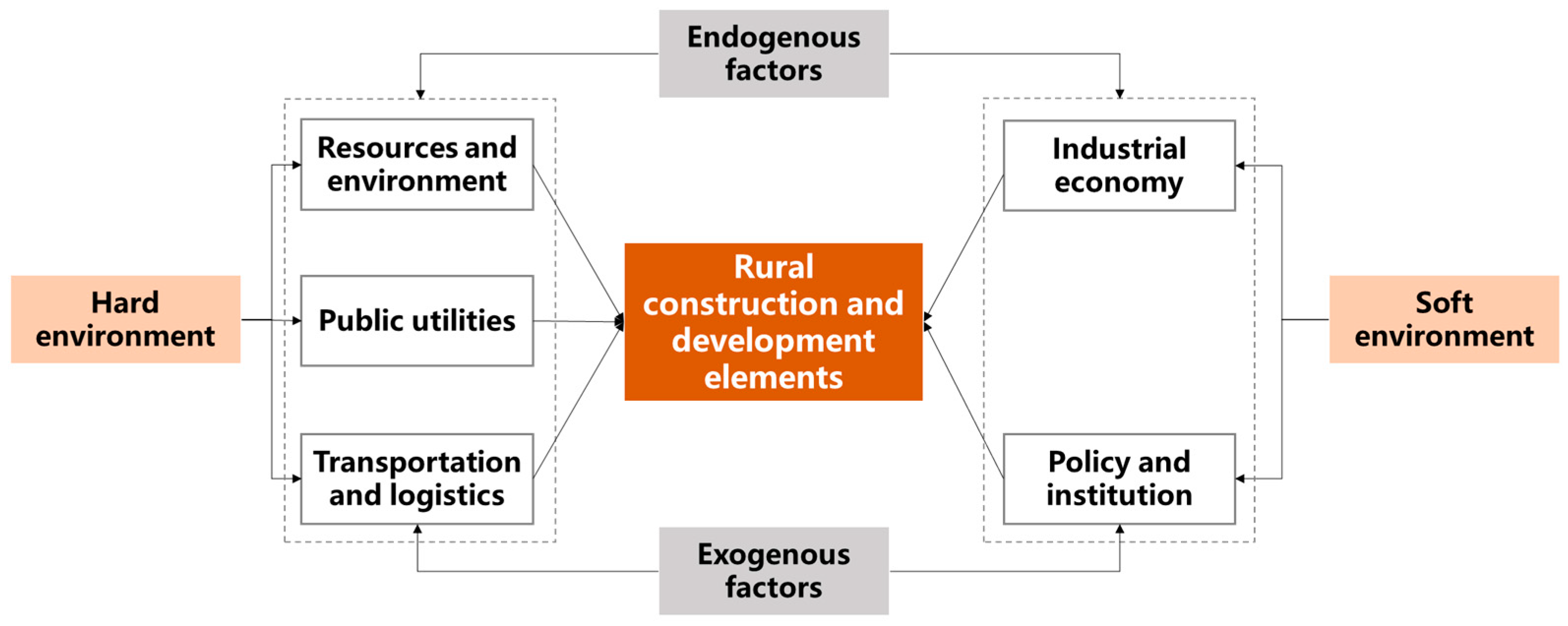
2. Evaluation Index System and Typical Development Modes for Rural Construction and Development in China

2.1. Evaluation Index System Based on Policy Text Analysis

This study aims to effectively respond to national policies and bridge the research gap in policy-oriented rural development evaluation indicator systems. It systematically analyzes policy bulletins to extract and summarize key development elements. Furthermore, it integrates insights from relevant literature reviews, balancing both soft and hard environmental elements, and aligning endogenous capabilities with exogenous driving forces to produce heterogeneity.
Systematic research on policy documents is based on departmental files and bulletins in the State Council’s policy document database. The following principles are followed in the selection of analytical data:
(1)
The keywords used for policy document title retrieval are “rural revitalization”, “rural development”, “village and town construction”, “county construction”, “urban-rural development”, and “living environment”;
(2)
The policy documents are publicly released by central ministries, their affiliated agencies, and managed national bureaus. The main issuers include the Central Committee of the Communist Party of China, the State Council, the National Development and Reform Commission, the Ministry of Housing and Urban-Rural Development, the Ministry of Agriculture and Rural Affairs, the Ministry of Natural Resources, and the Ministry of Finance, among others;
(3)
The policy documents were published between January 2018 and June 2022, which aligns with the release of the rural revitalization strategy;
(4)
The main types of policy documents include State Council documents, departmental documents of the State Council, and State Council bulletins. Specific document types include opinions, methods, plans, notifications, and outline plans, excluding replies, forwards, letters, and policy interpretations.
In the end, a database of national policy documents related to rural construction and development under the background of rural revitalization was formed, comprising a total of 217 documents. Using the titles and content of 217 documents as analysis units, the selected policy texts were encoded and analyzed using grounded theory to extract the elements of village and town development, summarize core conceptual categories, and ultimately form the framework of a feature characterization index system.
The grounded theory method generally includes three steps: open coding, axial coding, and selective coding. In our practical application, we used the first two steps. In the open coding analysis phase, we analyzed and summarized 217 pieces of data, ultimately forming 17 preliminary concepts. In the axial coding phase, we classified and processed categories with different relationships, and finally distilled them into five categories, namely industrial economy, public utilities, transportation and logistics, policy and institution, and resources and environment. These five categories essentially cover all aspects of rural construction and development and are suitable for representing the dimensions of the evaluation indicator system (Figure 2). The coding results are used as the primary and secondary indicator frameworks for characterizing the features of village and town development (Table 1).

2.2. Typical Development Modes

To offer practical guidance for rural town development, while ensuring alignment with national policies and local regulations, and considering applicability to both village and township administrative units, we present four typical rural town development models: the suburban fusion mode, the characteristic industry-oriented mode, the humanistic and ecological resource-based mode, and the balanced development mode with less distinct characteristics. For each mode, we summarize their characteristics (Table 2).

3. Decision Support System for Rural Construction and Development

3.1. System Overview

The decision support system consists of two main modules, including a multi-source information database and an integrated algorithm library for decision support.
The multi-source information database consists of two parts. Firstly, it includes a multi-source, heterogeneous big database that reflects the construction and development characteristics of villages and towns based on the five-dimensional indicator system (i.e., industrial economy, public utilities, transportation and logistics, policy and institution, resources and environment). Secondly, there is a case library of villages’ and towns’ typical construction and development experiences. The typical cases of well-developed villages and towns are collected and classified according to the four development modes (i.e., the suburban fusion mode, the characteristic industry-oriented mode, the humanistic and ecological resource-based mode, and the balanced development mode with less distinct characteristics). Furthermore, knowledge and experiences are extracted from the five dimensions proposed earlier to build the case library for benchmarking and learning purposes.
The integrated algorithm model library for decision support includes three functions for decision support: (1) typical development mode classification based on expert experience and a BP neural network; (2) evaluation and problem diagnosis using an entropy weight-based grey system comprehensive evaluation method; (3) experience benchmarking based on case matching using cosine similarity analysis.
The operation of the system is based on the classification of village and town development modes and the evaluation of feature indicators. The system establishes the benchmarking correspondence between the decision target in the big database and the learning target in the case library using integrated algorithms from the algorithm library. It accurately matches the target village and town with the most informative and similar ones in the case library and provides experience outputs. Figure 3 illustrates the operational architecture of the system. When a user selects a decision target village and town, the system first retrieves the target indicator data from the big database. It then applies the algorithm library for typical mode classification, feature characterization, and problem diagnosis. Finally, it matches the decision target with learning cases in the case library.
The system provides outputs in three aspects: (1) the mode classification result and development strategies of the decision target based on four development modes; (2) the evaluation and problem diagnosis results of the decision target based on five dimension indicator system; (3) the development experience of three matched learning cases, including the case with the highest similarity among the same mode with the decision target (as a short-term learning target, it provides references for policy formulation and implementation in the near term); the case with the highest score in problem dimension indicators among the same mode (this provides implementation plans addressing current major development issues); and the case with the highest total score among the same mode (as a long-term learning target, it provides promising directions and concepts for long-term planning and future development).

3.2. Multi-Source Information Database for Village and Town

3.2.1. Multi-Source Heterogeneous Big Database

Data sources include four aspects: (1) statistical data from the urban and rural construction statistical yearbook issued by Chinese government; (2) land use data interpreted using satellite remote sensing data (2020, 30 m resolution); (3) China STRM DEM data (2020, 30 m resolution); (4) standardized grid-based multi-source internet big data provided by a collaborative data research institute (2021). Among them, internet big data come from public electronic maps related to POI positioning, O2O websites, and online media posting websites. Village- and town-level data are obtained through geospatial-based computational processing.
The data structure is based on the five-dimensional indicator system and also takes into consideration data accessibility. It ultimately includes 48 indicators across the five dimensions (Table 1). Due to the difficulty in obtaining data at the township level, some indicators are provided at the county level as corrective data for township-level indicators.

3.2.2. Case Library of Typical Construction and Development Experiences

The data sources of the case library come from exemplary towns and villages with high levels of development and strong reference value in terms of construction and development experience, such as National Characteristic Towns, National Historical and Cultural Towns and Villages. The data on the development experience of typical cases is collected from field surveys, government websites, media news, WeChat public accounts, etc. The collected cases also need to be quantified to be entered into the big database. Initially, the cases are manually selected, structurally processed and classified according to its most prominent work aspect from the five dimensions of industrial economy, public utilities, transportation and logistics, policy systems, and resources and environment. Then, the cases are also classified into the four development modes based on system algorithms. The defined storage format and content outline of cases include five aspects: basic feature data, a background overview, supporting policy, development experience, and development achievements.

3.3. Integrated Algorithm Library for Decision Support

3.3.1. Algorithm 1: Development Modes Classification Based on BP Neural Network

The BP neural network is a nonlinear and adaptive information processing system composed of numerous interconnected processing units. It attempts to process information by simulating the way the brain’s neural network handles and stores information. Its main advantage lies in its powerful ability to perform nonlinear mappings and form feedforward neural networks with different characteristics. Consequently, it has superseded traditional models and finds extensive application in intricate fields including control systems, natural language processing, financial and economic forecasting, and other research domains [35,36,37]. Therefore, the BP neural network is used for classifying the integrated development patterns of rural areas. The specific steps are as follows: (1) Based on expert experience, out of 782 samples, 50 were manually selected from each of the four development modes, totaling in 200 samples for training the BP neural network classification prediction model (Table 3). (2) The evaluation indicators are used as the input layer after data standardization. Through multi-layer random sampling, the village samples are divided, with 25% of the samples allocated to the testing set and 75% to the training set. (3) The optimal neural network model for village classification is trained using the neuralnet() function in the R programming language.

3.3.2. Algorithm 2: Evaluation and Development Problem Diagnosis using Entropy Weight-Based Grey system Comprehensive Evaluation Method

The grey system comprehensive evaluation method is based on the Grey System Theory and aims to solve problems of small sample and insufficient information in system analysis. Considering a village or town as a multi-factorial grey system, it exhibits characteristics such as incomplete and uncertain information and hierarchical complexity. Therefore, it is suitable to employ this method for its comprehensive assessment. This method incorporates the entropy weight method driven by data to objectively adjust the weights of multiple indicators. This allows for the calculation of the grey correlation and its intensity among different factors.
The specific steps include the following: (1) Determining the reference sequence and comparison sequence. The reference sequence, denoted as x0, is composed of the optimal values of each indicator. The comparison sequence, denoted as xi, is used for correlation analysis. (2) Revising the weights of each indicator based on the entropy weight method. (3) Calculating the grey correlation coefficient (Formula (1)) and the comprehensive evaluation results for each of the five dimensions (Formula (2)).
ξ i i = Δ m i n + ξ Δ m a x x 0 j x i j + ξ Δ m a x
γ i = j = 1 m w j ξ i j
Δ m i n = min i min j x 0 j x i j indicates the minimum absolute error value of each indicator, and Δ m a x = max i max j x 0 j x i j indicates the maximum absolute error value of each indicator. ξ 0 , 1 represents the resolution coefficient, normally ξ 0.5 .
(4) Based on the classification results from the BP neural network, the average scores of the five dimensions for each mode are calculated, where the average scores are referred to as the benchmark lines within each mode. (5) The values of each dimension in the samples are compared with the corresponding benchmark line. Any dimension that falls below the benchmark line is considered a problematic dimension. (6) To facilitate a comprehensive comparison from an overall perspective, the weighted sum of the grey correlation coefficients for all five dimensions is calculated. This sum is referred to as the comprehensive score of the village (Formula (2)) and serves as a reference basis for the next step of case matching.

3.3.3. Algorithm 3: Benchmarking Learning Based on Cosine Similarity Analysis

The cosine similarity measurement method uses the cosine value of the angle between two sectors in multi-dimensional space as a measure of difference between two objects. Under this method, the similarity and difference between any two town samples can be compared using the multi-dimensional evaluation values by considering that they are two multi-dimensional sectors (x11, x12, …, x1n) and b (x21, x22, …, x2n) to find the optimal matching sample for experience learning (Formula 3).
cos ( θ ) = k = 1 n x 1 k x 2 k k = 1 n x 1 k 2 k = 1 n x 2 k 2
The range of values for the cosine similarity is [−1, 1]. A higher value indicates a smaller angle between the two vectors, indicating a greater similarity between the two vectors. This implies that the significance and effectiveness of benchmarking learning are higher when the cosine similarity is higher.

4. Implementation: Case Study of 782 Typical Chinese Towns

4.1. Study Sample

Townships serve as China’s primary governance units, providing essential public services to rural areas and driving rural industrial development. Promoting township development proactively is vital for urban–rural integration and rural revitalization. This study selects the top 1000 townships covered by the public fiscal budget revenue identified in the China Urban and Rural Construction Statistical Yearbook 2021 as basic data for the multi-source database and case library. Compared with those of other rural areas in China, these 1000 townships with higher public fiscal budget revenue have better economic conditions and larger population sizes, but still exhibit certain development gaps compared with urban areas. Generally, a higher public fiscal budget revenue indicates stronger local government financial capacity and a better quality of infrastructure and social services, which are, therefore, also suitable as benchmarking learning cases for underdeveloped rural areas.
After eliminating samples with missing data, 782 townships in total were selected as the study sample. These data samples are distributed across 24 provinces and municipalities nationwide, with a major concentration in the southeastern coastal region. Among them, Shandong, Jiangsu, Zhejiang, Shanghai, Fujian, and Guangdong provinces account for approximately 72% of the total samples.

4.2. Results

4.2.1. Result of Rural Construction and Development Evaluation and Problem Diagnosis

Using an entropy-weighted grey system evaluation method, we assessed 782 samples, obtaining composite scores ranging from 0.35 to 0.66, with an average of 0.37. These scores were used to categorize the samples into five groups, [0–5%), [5–20%), [20–40%), [40–70%), and [70–100%), indicating different levels of development from high to low.
Among the 782 townships assessed, the top 5% in high-level development have scores ranging from 0.41 to 0.66, and are mainly situated in the southeastern coastal provinces of Guangdong, Zhejiang, Jiangsu, and Fujian. Conversely, the lowest 30% in terms of development, with scores ranging from 0.35 to 0.36, are concentrated primarily in provinces such as Shandong, Fujian, Henan, and Hebei. This reflects a clear pattern: higher development levels in the southeast, moderate levels in the southwest and central regions, and lower levels in the northwest and northeast.
Among the 782 townships, the average scores for five dimensions are ranked as follows: resource and environment (0.4091), industrial economy (0.3480), transportation and logistics (0.3471), public facilities (0.3465), and policy and institutions (0.3437). Comparing the average scores of the top 5% and bottom 30% ranked townships to the overall average scores (score ratios), we find the largest differences in resource and environment (1.38), public facilities (1.29), and industrial economic (1.25) dimensions. The smallest differences are observed in the transportation and logistics (1.18) and policy and institution (1.14) dimensions (Figure 4).

4.2.2. Result of Rural Development Mode Classification

After training the BP neural network classification model, it was found that the optimal configuration includes two hidden layers with six and eight neurons, achieving accuracy rates exceeding 90% for each township type classification and an impressive average prediction accuracy of 96%, which indicates that the BP neural network model exhibits excellent predictive performance and high accuracy.
In the classification results, most townships are categorized as being in ‘balanced development mode with less distinct characteristics’ (317), followed by the ‘humanistic and ecological resource-based mode’ (205), and ‘characteristic industry-oriented mode’ (144). The fewest fall under the ‘suburban fusion mode’ (116).
Regarding their development levels, the average scores for these four township types, from highest to lowest, are as follows: the ‘suburban fusion mode’ (0.39), ‘humanistic and ecological resource-based mode’ (0.3808), ‘characteristic industry-oriented mode’ (0.3755), and ‘balanced development mode with less distinct characteristics’ (0.3553).”
Townships categorized as being in the ‘suburban fusion mode’, ‘humanistic and ecological resource-based mode’, ‘characteristic industry-oriented mode’, and ‘balanced development mode with less distinct characteristics’ exhibit relatively significant differences across three dimensions: resources and environment, industrial economy, and transportation and logistics. The extreme value ratios for these dimensions are 0.1620, 0.1290, and 0.1175, respectively. However, these townships show relatively smaller differences across two dimensions, public facility, and policy and institution, with extreme value ratios of 0.0924 and 0.0822, respectively (Figure 5).

4.3. Decision Support Results: Taking Huangjiang Township as an Example

Using Huangjiang Township in Dongguan City, Guangdong Province, as an example for learning and benchmarking, Huangjiang falls under the characteristic industry-oriented mode category. Its scores in the dimensions of industrial economy, transportation and logistics, resource environment, public facilities, and policy and institutions are 0.3801, 0.3411, 0.4738, 0.4050, and 0.3382, respectively. Notably, the transportation and logistics and policy and institutions dimensions are below the category average, indicating areas for improvement. Therefore, the system recommend benchmarking towns within the same category that excel in transportation and logistics and policy and institution development. Specifically, Humen Township from Guangdong and Chuanshaxin township from Shanghai are excellent cases for this purpose (Table 4).
Huangjiang Town is ranked 10th in its category. We used cosine similarity to benchmark it against the top nine samples in the category, and the results are in the table below. The analysis shows a high cosine similarity of 0.9999646 between Huangjiang and Qingxi Township, making them a suitable short-term benchmarking candidate due to their significant similarity. Additionally, Huangjiang exhibits a cosine similarity of 0.9779326 with the top-performing sample, Humen Township, indicating substantial feature overlap with some differences. This makes Humen a valuable long-term benchmarking target. All three recommended benchmarking cases can offer valuable development insights from the system case library (Table 5).

5. Discussion

5.1. Rural Construction and Development Evaluation System and Key Indicators

The rural construction and development evaluation system proposed in this study is based on current national policy priorities and construction elements. Its goal is to provide decision makers with guidance that harmonizes national policies and local characteristics. Many existing studies have comprehensive indicator systems, but they often originate from an academic perspective and may not align completely with national policy guidelines [10]. This misalignment can lead to regional policy disparities, resource inefficiencies, and uneven development [38]. In this study, we reviewed key policies in China’s rural revitalization phase and systematically identified and refined five major domains and twenty-one sub-domains. This approach bridges the gap between national macro policies and local practices, facilitating more effective rural township development and policy implementation.
On the other hand, the evaluation system aims to achieve a balanced development of various factors, both internal and external, and across soft and hard environmental elements in villages and towns. It serves as a valuable tool for decision makers to identify strengths and weaknesses in rural development systematically. Analyzing the characteristics of 782 sample townships based on these indicators reveals that rural townships in China generally have a strong resource environment. However, there is room for improvement in transportation and logistics, as well as in policy and institutions. This confirms the general consensus that many townships still heavily rely on their own resources for development and lack effective systems for managing external resources and enhancing self-service capabilities [39]. Furthermore, the primary factors contributing to development disparities among rural townships in China are the resource environment and public facilities. This suggests that well-developed townships often depend on resource exploitation and capital-intensive construction [40], which implies a need to reduce resource consumption and financial/material inputs to enhance sustainability.
In light of these findings, future rural township development should focus on establishing communication systems for internal and external resources, fostering resource sharing and cooperation in areas such as industries, talent, public services, and management within townships, with neighboring regions and cities. Additionally, there should be a focus on infrastructure development and optimizing public services to improve residents’ quality of life, attract talent, and investment. Ultimately, efforts should be channeled towards developing technology and innovation-driven industries to reduce reliance on traditional resources, create high-value job opportunities, and enhance the sustainability of environmental and industrial development.

5.2. Characteristics of Rural Development Modes and Tailored Policy Implications

To meet the demand for targeted policy implementation in China’s rural development, we have distinguished four typical modes by integrating central and local government guidance policies with relevant research. These modes offer guidance for both villages and higher-level township administrative units. Additionally, we have developed a machine learning-based classification model using the five-dimensional indicator system. Through a quantitative analysis of the distribution and development quality of the 782 sampled townships, we provide science-based development strategies for each township type.

5.2.1. The Suburban Fusion Mode

These townships, although few in number, boast the highest average development levels. Their proximity to major urban centers, like those in the Pearl River Delta and Yangtze River Delta regions, provides them with unique locational advantages that are hard to replicate. Across five key dimensions—resource environment, public facilities, industrial economy, transportation and logistics, and policy and institutions—they exhibit minimal weaknesses. Notably, their transportation and logistics development is outstanding.
These townships are prime candidates for expanding urban clusters, extending industrial chains, and elevating industrial transformations. Therefore, when planning and constructing such townships, it is crucial to consider the broader urban–rural spatial structure. Additionally, fostering bidirectional resource and production factor flows between urban and rural areas is essential. Prioritizing urban–rural industrial integration, infrastructure interconnectivity, and the collaborative development of public services is key. Achieving these objectives requires high-level coordination and development between urban and rural areas.

5.2.2. The Humanistic and Ecological Resource-Based Mode

This type typically comprises nationally renowned historical and cultural towns or villages, often located near national-level scenic areas. Their overall development level is slightly below that of the suburban fusion mode. These townships possess exceptional natural and historical resources and environmental advantages. However, their heavy reliance on tourism has led to underdevelopment in the other four dimensions, hampering sustainability.
To address these challenges, it is crucial to strike a balance between tourism development, environmental preservation, community protection, and cultural heritage when planning and constructing such townships. Given their abundance, it is also essential to avoid blind tourism development and homogenous competition. Leveraging their resource and environmental advantages, and improving living conditions and public services can enhance their appeal to innovative industries and talent, thereby fostering sustainable development through the integration of other sectors.

5.2.3. The Characteristic Industry-Oriented Mode

The townships under this type are relatively few in number, with an industrial economy development level just below that of the suburban fusion mode. However, as industrial growth can lead to issues like resource depletion, environmental pollution, and spatial disarray, there is significant room for overall enhancement in their development.
These townships should reinforce the pivotal role of their industries and prioritize spatial layout, transportation planning, and service facility configuration around these specialized sectors. This strategy will offer comprehensive support, fostering industrial growth and triggering a positive impact on neighboring rural areas. Furthermore, it is vital to establish appropriate policy systems and incentives that strike a balance between industrial expansion and environmental protection, encouraging a shift towards greener, more innovative, and higher-value-added industries.

5.2.4. The Balanced Development Mode with Less Distinct Characteristics

Townships of this type have the lowest average development level, with the lowest scores in all five dimensions, despite being the most common. This indicates that the prevailing future development trend for Chinese townships will involve improving their internal functionality.
Thus, when planning and developing such townships, the initial focus should be on infrastructure and public service development. Enhancing internal capabilities, including public management and community self-service capacities, and improving residents’ quality of life should be prioritized. Establishing effective operational and maintenance mechanisms is crucial. Industrial development can be pursued to the extent possible on this foundation.

5.3. Innovation of Smart Decision Support Tools

This study seamlessly integrates diverse data sources with various decision making algorithms to offer an efficient and precise method for the holistic rural construction and development decision making process. This approach covers mode classification, evaluation, problem diagnosis, and experiential benchmarking learning.
Importantly, we utilize a similarity matching approach based on the cosine similarity algorithm for benchmarking and learning in the context of rural development. Coupled with the creation of a repository of typical rural construction and development cases, we have successfully generated valuable insights. In the complex and resource-intensive realm of rural development, benchmarking is widely acknowledged as a cost-effective method that delivers immediate benefits and lays the groundwork for long-term returns [41,42]. This method is particularly well-suited for guiding rural development. Our system recommends prioritizing experiential learning from samples within the same category that are at a similar developmental stage and excel in problem diagnosis. This approach significantly boosts acceptance among grassroots management personnel and enhances decision making efficiency and success rates.
Furthermore, rural construction and development is a protracted and intricate dynamic process. Effective benchmarking and learning necessitate meticulous guidance to address crucial issues at various developmental stages. This study offers three benchmarking and learning options tailored to addressing immediate, long-term, and developmental challenges. These options aid policymakers and implementers in responding more effectively to changes and challenges in rural development, increasing their awareness of developmental trends, and facilitating timely adjustments and optimizations of policies and measures.

5.4. Limitation and Future Enhancement

This study has some limitations. First, the database and case library need to be further supplemented to cover villages and towns in different regions across the country, with more varying resource endowments and development levels. Second, the evaluation model and indicator system can be further optimized. The selection of indicators can be improved as data acquisition capabilities increase, and future research should focus on refining indicators and weights based on the resource characteristics of different regions. Third, this system currently relies on finite-state rule-based reasoning techniques, restricting its capacity to explore and uncover novel knowledge and strategies beyond the predetermined framework. In the future, it has the potential to integrate more sophisticated decision making theories, like computer-generated forces based on interactive simulation, and incorporate advanced algorithms such as multi-objective optimization and deep reinforcement learning. This integration aims to foster an open and dynamic evolution in rural decision making [43,44,45].

6. Conclusions

While national policies play a crucial role in shaping local development, effective governance is essential for rural revitalization. However, the successful implementation and impact of these policies in rural areas can vary due to unique local circumstances, limited information, and a lack of sophisticated decision making tools. Closing the gap between overarching national policies and practical rural development is an immediate necessity.
The study begins by creating a comprehensive five-dimensional evaluation system encompassing industrial economy, public utilities, transportation and logistics, policy and institutions, and resources and the environment. It then summarizes four typical development modes—the suburban fusion mode, the characteristic industry-oriented mode, the humanistic and ecological resource-based mode, and the balanced development mode with less distinct characteristics—through an analysis of the Chinese government’s policy framework for rural construction. Subsequently, it introduces a decision support system for rural construction and development founded on multi-source heterogeneous big data and integrated algorithms. This system was tested using 782 townships as samples for classification, evaluation, and decision support. The results leverage insights into current rural development trends to efficiently align with national policies and provide customized implementation recommendations tailored to local resource characteristics. These efforts significantly contribute to the practical execution of rural revitalization strategies and the advancement of scientific decision making in rural areas.

Author Contributions

Conceptualization, Y.J., W.C. and Z.J.; methodology, Z.J. and M.C.; software, M.C.; validation, Y.J.; formal analysis, M.C.; investigation, T.D.; resources, Y.J.; data curation, W.C.; writing—original draft preparation, Z.J.; writing—review and editing, Z.J.; visualization, Z.J.; supervision, Y.J.; project administration, Y.J.; funding acquisition, Y.J. All authors have read and agreed to the published version of the manuscript.

Funding

This research was funded by National Key R&D Program of China (2018YFD1100201); China Architecture Design and Research Group Research Project (1100C080220330).

Data Availability Statement

Data available on request due to restrictions privacy.

Conflicts of Interest

The authors declare no conflict of interest.

References

  1. Xing, L.; Hu, M.; Xue, M. The effect of urban–rural construction land transition on ecosystem services: A theoretical framework and empirical evidence for China. Habitat Int. 2022, 124, 102576. [Google Scholar] [CrossRef]
  2. Ma, L.; Liu, S.; Tao, T.; Gong, M.; Bai, J. Spatial reconstruction of rural settlements based on livability and population flow. Habitat Int. 2022, 126, 102614. [Google Scholar] [CrossRef]
  3. Huang, H.T. The Achievements in Poverty Alleviation Highlight China’s Powerful Political Advantages. People’s Daily. 18 February 2021. (In Chinese). Available online: http://opinion.people.com.cn/n1/2021/0218/c1003-32030340.html (accessed on 21 September 2023).
  4. She, Y.; Liu, Y.; Jiang, L.; Yuan, H. Is China’s river chief policy effective? Evidence from a quasi-natural experiment in the Yangtze River economic belt, China. J. Clean. Prod. 2019, 220, 919–930. [Google Scholar] [CrossRef]
  5. Deng, Q.; Li, E.; Yang, Y. Politics, policies and rural poverty alleviation outcomes: Evidence from Lankao County, China. Habitat Int. 2022, 127, 102631. [Google Scholar] [CrossRef]
  6. Wu, Y.; Liao, Y.; Xu, M.; He, J.; Tao, Y.; Zhou, J.; Chen, W. Barriers identification, analysis and solutions to rural clean energy infrastructures development in China: Government perspective. Sustain. Cities Soc. 2022, 86, 104106. [Google Scholar] [CrossRef]
  7. Alston, M. From local to global: Making social policy more effective for rural community capacity building. Aust. Soc. Work. 2002, 55, 214–226. [Google Scholar] [CrossRef]
  8. Wang, Y.; Cao, X. Village Evaluation and Classification Guidance of a County in Southeast Gansu Based on the Rural Revitalization Strategy. Land 2022, 11, 857. [Google Scholar] [CrossRef]
  9. Yan, Z.; Wu, F. From Binary Segmentation to Convergence Development—A Study on the Evaluation Index System of Rural Revitalization. Economies 2019, 31, 90–103. [Google Scholar]
  10. Xu, Y.; Wang, T.; Liu, W.; Zhang, R.; Hu, Y.; Gao, W.; Chen, Y. Rural system sustainability evaluation based on emergy analysis: An empirical study of 321 villages in China. J. Clean. Prod. 2023, 389, 136088. [Google Scholar] [CrossRef]
  11. Hu, S.; Yang, Y.; Zheng, H.; Mi, C.; Ma, T.; Shi, R. A framework for assessing sustainable agriculture and rural development: A case study of the Beijing-Tianjin-Hebei region, China. Environ. Impact Assess. Rev. 2022, 97, 106861. [Google Scholar] [CrossRef]
  12. Jia, Z.; Xu, S.; Zhang, Z.; Cheng, Z.; Han, H.; Xu, H.; Wang, M.; Zhang, H.; Zhou, Y.; Zhou, Z. Association between mental health and community support in lockdown communities during the COVID-19 pandemic: Evidence from rural China. J. Rural. Stud. 2021, 82, 87–97. [Google Scholar] [CrossRef] [PubMed]
  13. Lee, H.; Youn, Y. Relevance of cultural ecosystem services in nurturing ecological identity values that support restoration and conservation efforts. For. Ecol. Manag. 2022, 505, 119920. [Google Scholar] [CrossRef]
  14. Zhao, X.; Sun, H.; Chen, B.; Xia, X.; Li, P. China’s rural human settlements: Qualitative evaluation, quantitative analysis and policy implications. Ecol. Indic. 2019, 105, 398–405. [Google Scholar] [CrossRef]
  15. Liu, X.; Guo, P.; Nie, L. Applying emergy and decoupling analysis to assess the sustainability of China’s coal mining area. J. Clean. Prod. 2020, 243, 118577. [Google Scholar] [CrossRef]
  16. Huang, A.; Liu, B.; Zhang, A.; Zhan, J. Coordinated development of rural habitat in China: A study of measurement, spatio-temporal evolution and convergence. J. Clean. Prod. 2023, 398, 136651. [Google Scholar] [CrossRef]
  17. Wang, N.; Fang, M.; Beauchamp, M.; Jia, Z.; Zhou, Z. An indigenous knowledge-based sustainable landscape for mountain villages: The Jiabang rice terraces of Guizhou, China. Habitat Int. 2021, 111, 102360. [Google Scholar] [CrossRef]
  18. Jia, Z.; Gao, M.; Xu, S.; Lyu, Y.; Feng, J.; Zhou, Z.; Yu, T.; Wu, W. Sociocultural vitality versus regulation policy and tourism development in preservation of traditional rural landscape: A case from Guizhou, China. Int. J. Sustain. Dev. World Ecol. 2021, 28, 179–192. [Google Scholar] [CrossRef]
  19. Zhang, X.; Kanbur, R. Spatial Inequality in Education and Health Care in China Regional Inequality in China; Routledge: London, UK, 2009; pp. 92–110. [Google Scholar]
  20. Li, G.; Jiang, G.; Jiang, C.; Bai, J. Differentiation of spatial morphology of rural settlements from an ethnic cultural perspective on the Northeast Tibetan Plateau, China. Habitat Int. 2018, 79, 1–9. [Google Scholar] [CrossRef]
  21. Ji, Z.; Xu, Y.; Sun, M.; Liu, C.; Lu, L.; Huang, A.; Duan, Y.; Liu, L. Spatiotemporal characteristics and dynamic mechanism of rural settlements based on typical transects: A case study of Zhangjiakou City, China. Habitat Int. 2022, 123, 102545. [Google Scholar] [CrossRef]
  22. Jiang, Y.; Long, H.; Ives, C.D.; Deng, W.; Chen, K.; Zhang, Y. Modes and practices of rural vitalisation promoted by land consolidation in a rapidly urbanising China: A perspective of multifunctionality. Habitat Int. 2022, 121, 102514. [Google Scholar] [CrossRef]
  23. Tian, G.; Qiao, Z.; Gao, X. Rural settlement land dynamic modes and policy implications in Beijing metropolitan region, China. Habitat Int. 2014, 44, 237–246. [Google Scholar] [CrossRef]
  24. Xinhua News Agency. Strategic Planning for Rural Revitalization (2018–2022). Available online: http://www.xinhuanet.com/politics/2018-09/26/c_1123487123.htm (accessed on 21 September 2023).
  25. Guidelines for the Compilation of Overall Planning for Rural Land Space in Hebei Province (Trial Implementation); Department of Natural Resources of Hebei Province: Shijiazhuang, China, 2020.
  26. Guidelines for the Compilation of Overall Planning for Rural Land Space in Hunan Province (Trial Implementation); Department of Natural Resources of Hunan Province: Changsha, China, 2020.
  27. Guidelines for the Compilation of Overall Planning for Rural Land Space in Guizhou Province (Trial Implementation); Department of Natural Resources of Guizhou Province: Guiyang, China, 2021.
  28. Liao, Z.; Wang, B.; Xia, X.; Hannam, P.M. Environmental emergency decision support system based on Artificial Neural Network. Saf. Sci. 2012, 50, 150–163. [Google Scholar] [CrossRef]
  29. Mumali, F. Artificial neural network-based decision support systems in manufacturing processes: A systematic literature review. Comput. Ind. Eng. 2022, 165, 107964. [Google Scholar] [CrossRef]
  30. Fawzi, H.; Mostafa, S.A.; Ahmed, D.; Alduais, N.; Mohammed, M.A.; Elhoseny, M. TOQO: A new Tillage Operations Quality Optimization model based on parallel and dynamic Decision Support System. J. Clean. Prod. 2021, 316, 128263. [Google Scholar] [CrossRef]
  31. Capalbo, S.M.; Antle, J.M.; Seavert, C. Next generation data systems and knowledge products to support agricultural producers and science-based policy decision making. Agric. Syst. 2017, 155, 191–199. [Google Scholar] [CrossRef]
  32. Spänig, S.; Emberger-Klein, A.; Sowa, J.-P.; Canbay, A.; Menrad, K.; Heider, D. The virtual doctor: An interactive clinical-decision-support system based on deep learning for non-invasive prediction of diabetes. Artif. Intell. Med. 2019, 100, 101706. [Google Scholar] [CrossRef]
  33. Anderson, C.C.; Rex, A. Preserving the scenic views from North Carolina’s Blue Ridge Parkway: A decision support system for strategic land conservation planning. Appl. Geogr. 2019, 104, 75–82. [Google Scholar] [CrossRef]
  34. Moradi, S.; Yousefi, H.; Noorollahi, Y.; Rosso, D. Multi-criteria decision support system for wind farm site selection and sensitivity analysis: Case study of Alborz Province, Iran. Energy Strategy Rev. 2020, 29, 100478. [Google Scholar] [CrossRef]
  35. Basyal, G.P.; Rimal, B.P.; Zeng, D. A systematic review of natural language processing for knowledge management in healthcare. Comput. Sci. Inf. Technol. 2020, 275–285. [Google Scholar] [CrossRef]
  36. Zhang, P.; Yang, X.; Chen, Z. Neural network gain scheduling design for large envelope curve flight control law. J. Beijing Univ. Aeronaut. Astronaut. 2005, 31, 604–608. [Google Scholar]
  37. Zhang, H.; Luo, Y. Enterprise financial risk early warning using bp neural network under internet of things and rough set theory. J. Interconnect. Netw. 2022, 22, 2145019. [Google Scholar] [CrossRef]
  38. Farmer, J.; Philip, L.; King, G.; Farrington, J.; MacLeod, M. Territorial tensions: Misaligned management and community perspectives on health services for older people in remote rural areas. Health Place 2010, 16, 275–283. [Google Scholar] [CrossRef] [PubMed]
  39. Snyman, S. The impact of ecotourism employment on rural household incomes and social welfare in six southern African countries. Tour. Hosp. Res. 2014, 14, 37–52. [Google Scholar] [CrossRef]
  40. Kelly-Reif, K.; Wing, S. Urban-rural exploitation: An underappreciated dimension of environmental injustice. J. Rural. Stud. 2016, 47, 350–358. [Google Scholar] [CrossRef]
  41. Nair, V.; Hussain, K.; Lo, M.C.; Ragavan, N.A. Benchmarking innovations and new practices in rural tourism development: How do we develop a more sustainable and responsible rural tourism in Asia? Worldw. Hosp. Tour. Themes 2015, 7, 530–534. [Google Scholar] [CrossRef]
  42. Simms, A.; Freshwater, D.; Ward, J. The Rural Economic Capacity Index (RECI) A Benchmarking Tool to Support Community-Based Economic Development. Econ. Dev. Q. 2014, 28, 351–363. [Google Scholar] [CrossRef]
  43. Kase, S.E.; Hung, C.P.; Krayzman, T.; Hare, J.Z.; Rinderspacher, B.C.; Su, S.M. The future of collaborative human-artificial intelligence decision-making for mission planning. Front. Psychol. 2022, 13, 850628. [Google Scholar] [CrossRef]
  44. Yang, X.; Gong, G.; Tian, Y.; Yu, X. Generalized Optimal Game Theory in virtual decision-makings. In Proceedings of the 2008 Chinese Control and Decision Conference, Yantai, China, 2–4 July 2008; pp. 1960–1964. [Google Scholar]
  45. Yang, X.; Gong, G.; Tian, Y. Optimal game theory in complicated virtual-modeling and CGF decision-making with multi-granularities. In Proceedings of the 2008 International Conference on Smart Manufacturing Application, Goyangi, Republic of Korea, 9–11 April 2008; pp. 95–99. [Google Scholar]
Figure 1. Research technical process.
Sustainability 15 16152 g001
Figure 2. Theoretical framework for rural construction and development evaluation system.
Sustainability 15 16152 g002
Figure 3. System overview.
Sustainability 15 16152 g003
Figure 4. Evaluation result based on five-dimensional indicator system.
Sustainability 15 16152 g004
Figure 5. Four development modes based on five indicator dimensions.
Sustainability 15 16152 g005
Table 1. The coding process and the indicators for characterizing village and town features.
Category/
Primary Indicator
Preliminary Concepts/
Secondary Indicator
Representative Policy Documents (Analysis Sample)Indicator
A-1.
Industrial economy
B-1.
Agriculture
Notification from the General Office of the Ministry of Agriculture and Rural Affairs on Issuing the Guiding Opinions for Promoting the Construction of Ecological Farms.C-1. Number of companies and enterprises
C-2. Number of industrial enterprises
C-3. Number of large-scale industrial enterprises
B-2.
Industry
Reply from the Ministry of Agriculture and Rural Affairs Regarding Approval of the Construction of China (Zhaodong) International Agro-product Processing Industrial Park in Heilongjiang Province.
B-3.
Service industry
Notification on Issuing the Guiding Opinions on Promoting the Sustainable Development of Rural Tourism. C-4. Number of financial and insurance-related services
C-5. Business environment index
C-6. Industrial coordination level
C-7. Index of high-quality industrial development
B-4.
Macroeconomic regulation and control
Guiding Opinions of the Ministry of Agriculture and Rural Affairs on Expanding the Multi-functional Roles of Agriculture to Promote High-quality Development of Rural Industries.C-8. Population density
C-9. Labor force proportion
C-10. Proportion of elderly population
C-11. Rural per capita disposable income
C-12. Rural per capita disposable income growth rate
C-13. Urban per capita disposable income
C-14. Urban per capita disposable income growth rate
C-15. Engel Coefficient for Rural Households
A-2. Resources and environmentB-5.
Land and resources
Notice from the Office of the Ministry of Natural Resources on Strengthening Village Planning to Promote Rural Revitalization.C-16. Land Use Diversity
B-6.
Historical and cultural resources
The General Office of the Communist Party of China Central Committee and the General Office of the State Council issued Opinions on Strengthening the Protection and Inheritance of Historical and Cultural Heritage in Urban and Rural Construction. C-17. Number of scenic spots
B-7.
Clean energy resources
Notice on the issuance of the “Implementation Opinions on Accelerating Rural Energy Transition and Supporting Rural Revitalization”.C-18. Proportion of excellent air quality days
B-8.
Ecological environment
Announcement regarding the naming of the third batch of national ecological civilization construction demonstration cities and counties.C-19. Average Terrain Relief
C-20. Average Altitude
A-3.
Public utilities
B-9.
Public services
Notice from the National Radio and Television Administration on the issuance of “Guiding Opinions on Promoting the Construction of Smart Radio and Television in Rural Areas.”
Guiding opinions from the General Office of the State Council on comprehensively strengthening the construction of small-scale rural schools and rural boarding schools.
C-21. Number of sports and leisure-related services
C-22. Number of healthcare-related services
C-23. Number of automobile-related services
C-24. Number of catering-related services
C-25. Number of shopping-related services
C-26. Number of daily-life-related services
C-27. Number of science and technology culture-related services
C-28. Coverage rate of medical and healthcare institutions in towns and townships
C-29. Number of comprehensive stores or supermarkets with an operating area over 50 square meters
B-10.
Infrastructure
Notice from the Office of the Ministry of Water Resources on increasing support for rural living environment improvement through water conservancy measures.
Opinions on actively promoting the substitution of work for aid in the construction of agricultural and rural infrastructure.
C-30. Infrastructure coordination index
C-31. Urban–rural coordination index
B-11.
Rural housing
Notice from the Ministry of Housing and Urban-Rural Development on the issuance of the “Technical Guidelines for Rural Housing Safety Assessment”.C-32. Number of accommodation-related services
C-33. Number of business residences
A-4. Transportation and logisticsB-12.
Logistics and passenger transportation
Opinions from the General Office of the State Council on accelerating the construction of rural postal and logistics systems.C-34. Rural road connectivity rate
C-35. Road network density
C-36. Road network coverage score
C-37. Score of town-to-village road network
B-13.
Highway construction and management
Notice from the Ministry of Transport on the issuance of the “Measures for Quality Management of Rural Road Construction”.C-36. Number of transportation facility-related services
C-39. Number of subsidiary facilities for roads
A-5.
Policy and institution
B-14.
Social security and management
Notice from the Ministry of Civil Affairs and the National Rural Revitalization Administration on mobilizing and guiding social organizations to participate in rural revitalization work.C-40. Government institutions and social organizations
C-41. Number of public facilities
C-42. Medical service satisfaction score
C-43. Positive public sentiment volume
B-15.
Talent development policy
Notice from the Ministry of Human Resources and Social Security and the National Rural Revitalization Administration on the issuance of the “Implementation Plan for the National Rural Revitalization Key Support Areas Vocational Skills Enhancement Project”.C-44. Education service satisfaction score
C-45. Employment innovation vitality score
B-16.
Land management policy
Notice issued by the General Office of the Communist Party of China Central Committee and the General Office of the State Council on adjusting and improving the scope of land transfer revenue utilization to prioritize supporting rural revitalization.C-46. Environmental protection satisfaction score
B-17.
Fiscal and financial policy
Opinions of the Ministry of Agriculture and Rural Affairs and China Postal Savings Bank on Strengthening Financial Cooperation in the Agricultural Industrialization Field to Promote the Implementation of the Rural Revitalization Strategy.C-47. Score of public service capacity
C-48. Score of adequacy of public service supply
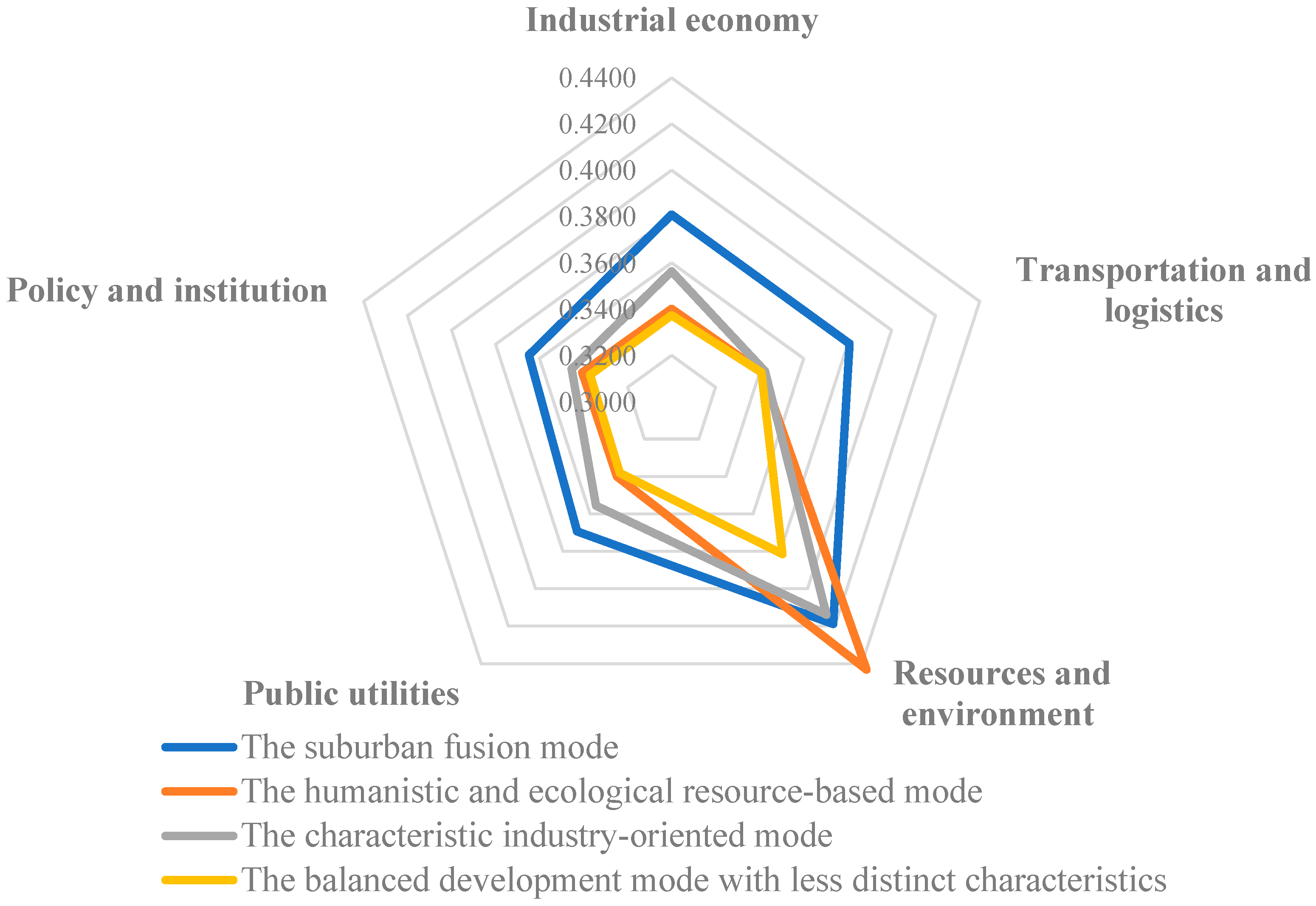
Table 2. Typical development modes.
ModeCharacteristics
The suburban fusion modeThis refers to the village and town located around and closely connected to the urban areas, which are usually involved in the urban development boundary of cities and counties.
The characteristic industry-oriented modeThis refers to the village and town with well-developed economies, notable industrial advantages and characteristics, and a certain driving effect on surrounding rural areas.
The humanistic and ecological resource-based modeThis refers to the village and town that have prominent natural ecological or historical and cultural resources, as well as the foundation and potential for tourism development.
The balanced development mode with less distinct characteristicsThis refers to the village and town that pursue balanced and diversified development but currently lack prominent characteristics found in the aforementioned modes.
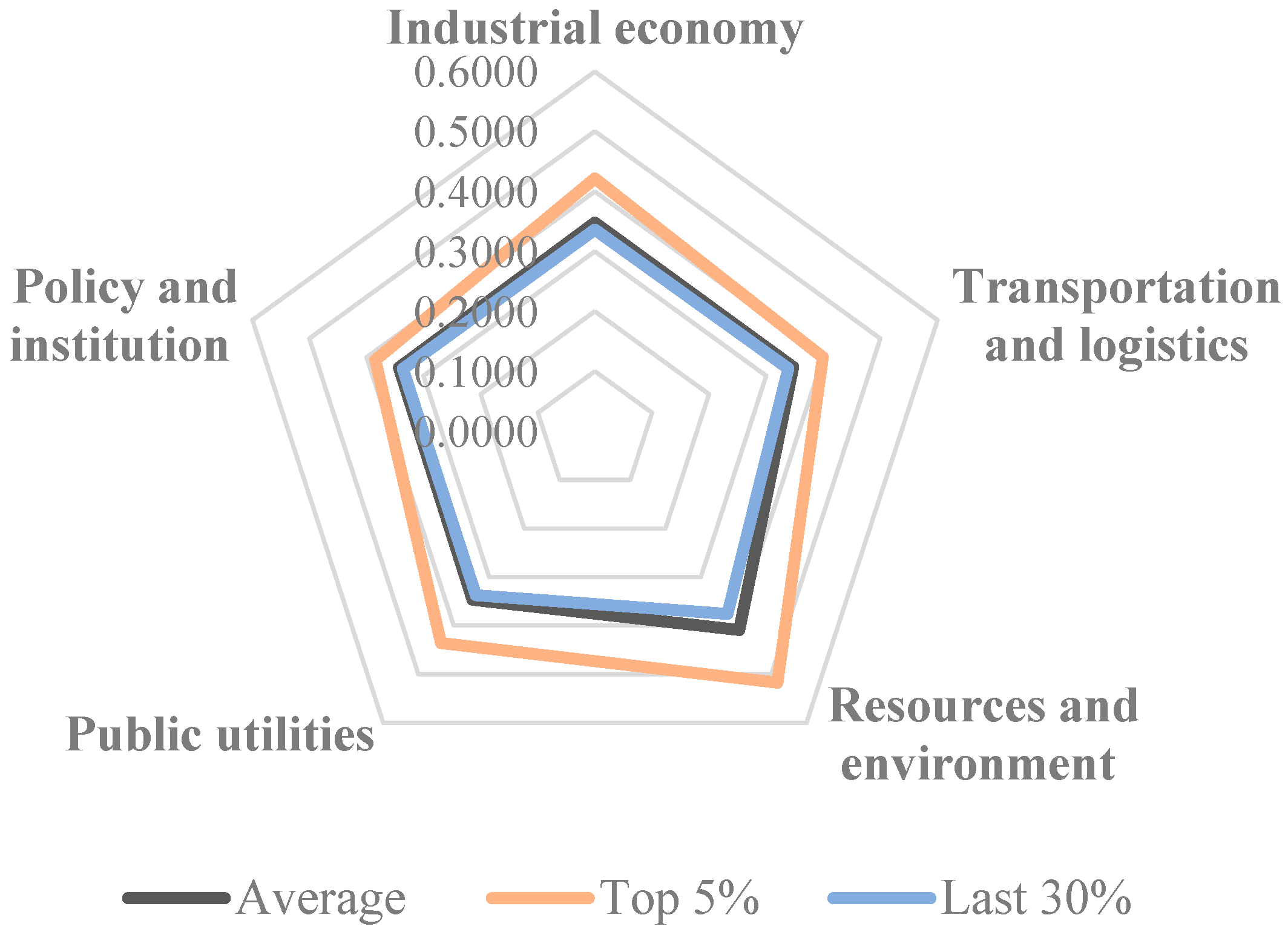
Table 3. Five-dimensional feature values of the 200 training samples.
Development ModeNIndustrial EconomyTransportation and LogisticsResources and EnvironmentPublic UtilitiesPolicy and Institution
The suburban fusion mode500.41350.40320.43220.3910.3853
The humanistic and ecological resource-based mode 500.34160.34260.46780.34110.3417
The characteristic industry-oriented mode500.37160.3470.4350.38140.3524
The balanced development mode with less distinct characteristics500.33620.33610.37640.33640.3365
Average value2000.36570.35720.42780.36250.354
Table 4. Evaluation results of Huangjiangzhen and benchmarking targets.
NameIndustrial EconomyTransportation and LogisticsResource and EnvironmentPublic UtilitiesPolicy and Institutions
Huangjiang township (decision support sample)0.38010.34110.47380.4050.3382
Humen township
(recommended town)
0.49920.36720.55690.72920.348
Shazhen township
(recommended town)
0.37520.37480.42020.37240.3962
Average score of Characteristic industry-oriented mode0.3530.34270.41350.35290.343
Table 5. Cosine similarity of Huangjiang township with potential benchmarking targets.
Benchmarking TargetCosine Similarity of Huangjiang Township
Humen township0.9779326
Houjie township0.9831115
Dalang township0.9900775
Liushi township0.9938182
Tangxia township0.9935713
Fenggang township0.9995923
Qingxi township0.9999646
Daling township0.9997025
Longjiang township0.9986612
Disclaimer/Publisher’s Note: The statements, opinions and data contained in all publications are solely those of the individual author(s) and contributor(s) and not of MDPI and/or the editor(s). MDPI and/or the editor(s) disclaim responsibility for any injury to people or property resulting from any ideas, methods, instructions or products referred to in the content.

