Article

Study on the Variation in Coastal Groundwater Levels under High-Intensity Brine Extraction Conditions

1
Key Laboratory of Marine Sedimentology and Environmental Geology, First Institute of Oceanography, Ministry of Natural Resources, Qingdao 266061, China
2
Laboratory for Marine Geology, Qingdao National Laboratory for Marine Science and Technology, Qingdao 266061, China
*
Author to whom correspondence should be addressed.
Sustainability 2023, 15(23), 16199; https://doi.org/10.3390/su152316199
Submission received: 14 October 2023 / Revised: 14 November 2023 / Accepted: 20 November 2023 / Published: 22 November 2023

Abstract

:
The excessive exploitation of groundwater is becoming a serious global issue. Different from other regions, groundwater extraction in coastal areas usually stops and moves inland after causing seawater intrusion. The abundant salt fields in the Laizhou Bay area of China provide a unique case of maintaining high-intensity underground brine mining even after seawater intrusion. The intensive exploitation of underground brine has led to significant changes in the groundwater flow field. However, there is still a lack of research on how different factors affect the groundwater level in this mining situation. In this paper, time series analysis methods were used to investigate the impact of brine water extraction, tidal fluctuations, and precipitation on the groundwater level in the Laizhou Bay area. The results indicate that brine extraction is the main factor controlling the changes in groundwater level, with the cessation and resumption of extraction resulting in a 93.4 cm increase and a 122.5 cm decrease, respectively. Different rainfall patterns can also lead to an increase in groundwater levels, especially when a heavy rainfall event can cause a 61.2 cm increase. Tidal fluctuations can cause periodic fluctuations in the groundwater level, with a variation amplitude of approximately 11% of the tide itself.

1. Introduction

Due to population growth and economic development, the demand for water by humans is rapidly increasing, and water resources in many regions of the world are becoming increasingly scarce [1,2,3]. Coastal areas are usually densely populated and economically developed, which increases the demand for groundwater and raises people’s interest in assessing the environmental problems caused by excessive groundwater exploitation [4,5].
Since the 1950s, studying the dynamic relationship between seawater and fresh groundwater in coastal areas has become an active research field [6]. The fluctuation in the water level in coastal aquifers can be caused by two different factors: groundwater extraction and tidal forces. Groundwater extraction leads to a decline in the water level [7], which will rise and reach a new equilibrium after the extraction is stopped, while tidal forces can cause daily fluctuations in the water level. By continuously and intermittently observing the water level in coastal aquifers, the tidal effect can be observed [8]. Tidal forces are also an important mechanism for the movement of saturated and intertidal zone pore water [9]. Tides significantly affect the spatial–temporal patterns of groundwater level fluctuations and exhibit certain regularities [10]. The periodic influence of coastal aquifer water levels has been studied for many years [11]. The study of tidal-induced fluctuations in coastal groundwater levels has played a positive and crucial role in improving our understanding of the interaction between fresh groundwater and seawater [12].
Rainfall is also an important factor affecting groundwater dynamics in coastal areas [8]. The rising groundwater level with rainfall is a complex phenomenon, as it is influenced by many factors. Many precious studies have utilized empirical and theoretical frameworks to describe the relationship between the response of groundwater levels to rainfall. These methods are mainly applicable to shallow groundwater, where individual rainfall events are closely related to groundwater level fluctuations [13].
The coastal plain of Laizhou Bay in Northern China is rich in brine resources. Due to its wide distribution, this plain is one of the main areas for the distribution of the brine chemical industry in China, and it is also the largest production base for raw salt and bromine in China. However, in recent decades, due to insufficient research and poor mining management, overexploitation of brine has led to the formation and continuous expansion of salt water subsidence zones [14]. These subsidence areas have changed the original dynamic conditions of groundwater, leading to a decline in water levels. In non-mining areas, based on the continuous monitoring of several nearby wells, tides and rainfall can be used to predict groundwater levels [8]. However, research on the impact of different factors on groundwater level changes in brine mining areas has not yet been conducted.
Excessive pumping in brine areas will significantly reduce brine salinity [14], especially in the Laizhou Bay area; the sustained supply of seawater, surface water, and fresh groundwater has caused the continuous dilution of brine [15]. The current disordered brine mining pattern is unsustainable, and the mining output of underground brine cannot maintain the long-term demand of the local chemical industry. The water level is an important parameter in groundwater hydrology, which can reveal the spatio-temporal information of the aquifer. Quantitative analysis of the influencing factors of groundwater level can help managers to better plan groundwater utilization and make appropriate decisions, ensuring the sustainable development of the local brine industry.
Time series analysis is becoming an increasingly important method for studying the temporal variations in groundwater, and it can be used to determine the main influencing factors of different hydrological processes and explain the response of aquifers to natural system changes [11,16]. This study uses time series analysis methods to study the effects of rainfall, tidal fluctuations, and brine extraction on coastal groundwater levels based on high-frequency observation data in coastal Laizhou Bay.

2. Materials and Methods

2.1. The Study Area

Laizhou Bay is the largest semi-enclosed bay in the Bohai Sea, and it is located in the northern part of the Shandong Peninsula, China (Figure 1). The annual average temperature is 12 °C, and the annual average precipitation is approximately 630 mm, with June to September accounting for 70%. The estimated annual average evaporation is 1640 mm, mainly occurring from April to June. The unique meteorological and hydrological conditions, as well as the ancient geographical and topographical features in southern Laizhou Bay, provide suitable conditions for the formation of local brine [17,18]. Since the mid-late Pleistocene, three large-scale transgressions and regressions have occurred in this area, resulting in the formation of three brine aquifers at depths of 0–15 m, 33–42 m, and 59–74 m, respectively [19].
Shallow groundwater is primarily replenished by atmospheric water and lateral inflow from rivers, mainly through atmospheric evaporation and groundwater extraction discharge. Under natural conditions, fresh groundwater flows from south to north towards the coastline through alluvial and marine sediments in the Laizhou Bay area. The presence of clay layers between different sedimentary layers may inhibit vertical mixing between these saline layers. The hydrodynamics of the confined aquifers and deep artesian aquifers are influenced by climatic and hydrological factors, particularly the impact of groundwater extraction rates. Excessive exploitation of freshwater and brine resources has led to changes in the natural groundwater flow regime [20].
Since the mid-1970s, there has been a decrease in precipitation and a severe scarcity of surface water resources in the study area, and the amount of groundwater recharge has also been declining year by year. The increasing demand for groundwater has led to a continuing decline in groundwater levels and the formation of a fresh groundwater depression in the south of the study area. At the same time, the exploitation of brine has not been scientifically managed, resulting in the formation of an underground brine depression in the north of the study area. The target layer for brine extraction has gradually deepened from the phreatic aquifer in the 1970s to a current depth of 80 m [21].

2.2. Data Collection

In order to obtain field observation data on groundwater levels, a monitoring well was designed in a location adjacent to the coast in southern Laizhou Bay (Figure 1). The monitoring well is located on the inner side of the seawall with a depth of 20 m, and the observation layer is the phreatic aquifer.
A groundwater level sensor (Micro-Diver) was installed in the observation well to monitor the changes in groundwater level and conductivity continuously from 7 June 2022 to 25 April 2023. Prior to installation, the monitoring equipment underwent calibration and adjustment once daily for one week to ensure the reliability of the data. The observation frequency was set at one measurement per hour, resulting in a total of 7731 h of continuous data. Due to the conductivity exceeding the range, only continuous data on the groundwater level were collected.
The tidal data used in this study were obtained from the open-source program Delft Dashboard (http://publicwiki.deltares.nl/display/OET/DelftDashboar, accessed on 23 May 2023). Its tidal station toolbox provides online access to the XTIDE and IHO tidal databases, which contain tidal components from thousands of tidal stations worldwide [22]. The data we used cover the period from 7 June 2022 to 25 April 2023, which aligns with the groundwater level observation period. The data were collected at an hourly frequency, and the location of the tidal station is shown in Figure 1.
The precipitation data were obtained from the NOAA Integrated Surface Dataset (ISD). ISD is a global database that consists of hourly and synoptic surface observations compiled from numerous sources into a single common ASCII format and common data model [23]. The name of the meteorological station used for this paper is WEIFANG, CH, where the station code is 54843099999, and its location is shown in Figure 1. The data selected for analysis corresponded to the same date range as the observation well monitoring period.
It is worth noting that the southern side of the observation well is a salt field where large-scale underground brine extraction is currently taking place. The extraction of brine is only halted for approximately two months during the winter season. In the period of observation for this study, the cessation of extraction occurred on 23 November 2022, and the resumption of extraction is scheduled for 19 January 2023.

2.3. Methodology

Time series analysis encompasses various techniques, ranging from classical statistical analysis to spectral analysis. Fourier transform and Laplace transform are undoubtedly among the most valuable and powerful tools in theoretical and applied mathematics, with Fourier transform playing the most prominent role [24]. The amplitude and frequency spectrum obtained from Fourier transform provides a more natural basis for observing relevant physical phenomena [25]. Fourier analysis of water level fluctuations is a simple yet underutilized tool that can aid in characterizing shallow groundwater systems [26]. This study employed software Matlab (R2021a) to perform Fourier transform calculations as part of the frequency analysis, and the basic theory has been presented by [27].
Wavelet analysis is a more effective tool than Fourier transform analysis for analyzing non-stationary time series. It has been widely applied in fields such as oceanography, meteorology, and hydrology [28,29]. Wavelet coherence is an advanced mathematical technique that measures the correlation between two spatial sequences on different scales and at different positions. It is commonly used to examine scale-specific and position-specific correlations between two variables [30]. In this paper, wavelet coherence analysis was conducted on tidal levels and groundwater levels using the open-source software Acycle 2.4.1 [31]. The specific algorithm came from [32].
Singular spectrum analysis (SSA) is a powerful technique in time series analysis that has been developed and applied to many practical problems. Its purpose is to decompose the original series into a small number of independent and interpretable components, such as slowly varying trends, oscillatory components, and unstructured noise [33]. SSA has been proven to be particularly effective in extracting information from short and noisy time series, even in cases where the (nonlinear) dynamics influencing the time series are not known in advance [34]. Therefore, SSA is capable of effectively extracting the important components of hydrological time series that exhibit irregular behavior characteristics [35]. In this study, the SSA analysis was implemented in open-source R4.1.3 software, and [36] provided the user manual and specific algorithms for the method.
Prediction is a common task in data science that can help organizations with capacity planning, goal setting, and anomaly detection. Despite its importance, there are still significant challenges in generating reliable and high-quality predictions. The prophet model is an additional model for time series forecasting, which was open-sourced by Facebook in 2017. It is particularly suitable for time series with strong periodic effects, and it is robust to changes in trends. The model decomposes the time series into three main components: the seasonal component, the trend component, and the residual component. It fits a wide range of data relatively well. We conducted predictive analysis on the groundwater level based on the prophet model; please refer to [37] for more details.

3. Results

3.1. Characteristics of Time Series Variations

Understanding the temporal variations in hydrological processes and their associated statistical data is crucial for effective water resource management [38]. The astronomical tides in Laizhou Bay are irregular semidiurnal, with southward flow during high tide and northward movement during low tide (Figure 2a). The tidal elevation at the open boundary in the North Yellow Sea is composed of eight major constituents (M2, S2, N2, K2, K1, O1, P1, Q1) [39]. Using software S_TIDEv1.1 [40], the tidal data at WEIFANG station were analyzed, revealing an average high tide of 25.46 cm, an average low tide of −28.02 cm, an average ebb duration of 6.151 h, and an average flood duration of 7.08 h.
The maximum observed groundwater level in the monitoring well was −7.107 m, occurring on 23 January 2023, at 19:00, while the minimum value was −8.806 m, occurring on 8 June 2022, at 16:00, and the average groundwater level was −8.01 m (Figure 2b).
From the temporal distribution of rainfall (Figure 2c), the observed rainfall during the study period was mainly concentrated from June to September, which is consistent with the long-term observations. Among them, the highest daily rainfall occurred on 9 August 2022, reaching 3.16 cm, and it continued until 13 August, with a cumulative rainfall of 6.24 cm. There was a heavy rainfall event from 1 October to 3 October 2022, with an accumulated rainfall of 5.86 cm within a short period of time.

3.2. Frequency of Observation Data

Most hydrogeological phenomena are characterized by periodic and time-varying patterns [41]. The loosely formed coastal aquifers may be influenced by the semi-diurnal components of the adjacent seawater. Based on the tidal data from Laizhou Bay, clear periodic phenomena can be observed. Similarly, the observed groundwater levels also exhibit weak periodic fluctuations, which are easily overlooked when overshadowed by long-term trends (Figure 2b). In order to better analyze the periodic variations in tidal and groundwater fluctuations, this study employed Fourier transform calculations on the frequency characteristics of tides and observed groundwater levels.
The amplitude–frequency analysis results indicate that the tidal level exhibits two distinct peak ranges (Figure 2d), 0.038–0.042 and 0.080–0.083, corresponding to approximately 12 and 24 h periods, respectively. Within each peak frequency range, two peaks are observed, which can be attributed to the influence of different tidal constituents [42].
In terms of the frequency of water level variations, although the frequency changes are more complex compared to the tidal cycles, it is evident that there is consistency between the approximately 12 and 24 h periods, and there are also two peaks in each peak frequency range (Figure 2e).

3.3. Wavelet Coherence

Wavelet coherence can effectively reflect the “correlation” between two different time series changes. In this study, wavelet coherence analysis was conducted on tidal levels and groundwater levels (Figure 3). The color bar represents the degree of coherence between the two time series, with warm colors indicating strong correlation and cool colors indicating weak correlation. The results showed that the high-energy regions of groundwater levels and tidal levels exhibited a continuous distribution in a strip-like pattern, with significant common characteristics at approximately 12 and 24 h periods, indicating a strong correlation, consistent with the frequency analysis.

3.4. Singular Spectral Decomposition

The first step in applying SSA is to select the window size, denoted as L. SSA is capable of decomposing signals with periods ranging from L/5 to L [43]. Since tidal- and groundwater level variations are primarily concentrated in the 12 and 24 h periods, SSA is applied with a window size of L = 60 to identify the main temporal scales of tidal variations.
Based on the w-correlation plot obtained from the SSA analysis (Figure 4), it is recommended to select the first eight reconstructed components (RCs), and frequency analysis is then performed on each RC (Figure 5). In the frequency distribution of RC4 and RC5, two peaks align with the 12 h tidal period. Similarly, in the frequency distribution of RC6–RC8, two peaks align with the 24 h tidal period.

3.5. Forecasting

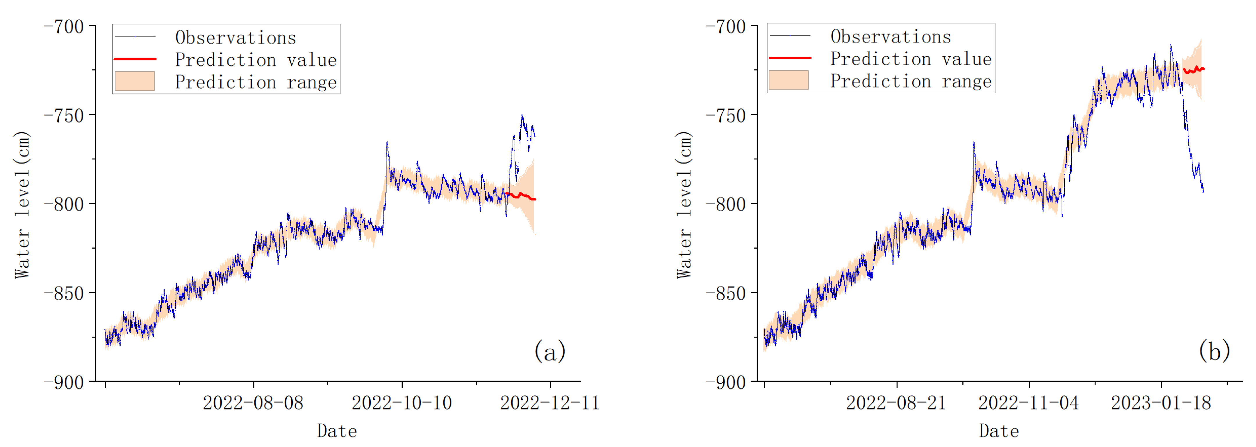
Large-scale underground brine extraction is taking place on the south side of the observation well. During the study period, there was a cessation period of approximately two months. In order to analyze the impact of brine extraction on the groundwater level, we conducted predictive analysis on the groundwater level during the cessation and resumption of brine extraction based on the prophet model.
The predictive results indicate that if underground brine extraction continues consistently, the groundwater level will continue to decline (Figure 6a). However, the decline will not be significant, and even the highest predicted water level will be much lower than the actual water level after the cessation of extraction. Similarly, if extraction is halted, the groundwater level will experience a slight upward trend, and the predicted lowest water level will be much higher than the actual water level after the resumption of extraction (Figure 6b). This demonstrates that the impact of underground brine extraction on the groundwater level is highly significant.

4. Discussion

Based on previous research, numerous factors can influence the dynamics of groundwater, with rainfall and human activities being the most common ones [44]. In the groundwater system of coastal areas, tidal effects also play a significant role [5], while along the coast of Laizhou Bay, this is further complicated due to the simultaneous extraction of both freshwater and brine groundwater [14].
The rise in the groundwater level in response to rainfall is a complex phenomenon influenced by multiple factors [13]. The impact of rainfall on nearshore groundwater is likely to be long-term and cumulative, resulting in a lagged response of groundwater levels, where the current behavior of groundwater depends on past rainfall events [45]. Due to the long-term existence of high-intensity underground brine mining in the research area, the impact of rainfall on groundwater level changes is weakened compared to that in other places, which poses some difficulties in trying to analyze the relationship between rainfall and groundwater level.
Based on two representative rainfall events, a continuous rainfall process occurred from 9 August to 13 August 2022, with an accumulated rainfall of 6.24 cm, causing the groundwater level to rise by 23.7 cm (from −839.5 to −815.8 cm). During a heavy rainfall event from 1 October to 3 October 2022, a short-term accumulated rainfall of 5.86 cm resulted in a groundwater level increase of 61.2 cm (from −817.6 to −756.4 cm). Although the total rainfall in August was higher than that in October, the latter caused a much greater rise in water levels, indicating that, in addition to accumulated rainfall, rainfall patterns also have a significant impact on water level changes. In the research area, the intensity of short-term heavy rainfall has a more significant impact on water level elevation. The water level change caused by a single heavy rainfall event can exceed 36% of the total observed water level change (169.9 cm) during the observation period.
Tidal dynamics are an important component of coastal hydrology, and the periodic influence of tidal pressure on the groundwater level in coastal aquifers has become an active research area [8,11]. However, there is still limited research on identifying the impact of tidal fluctuations on groundwater levels under conditions of intensive human groundwater extraction. In addition to long-term trends, groundwater levels also exhibit short-term fluctuations. By using Fourier transform, the periodic range of each component can be determined (Figure 2). The results show that the low-frequency component in groundwater levels is significant, indicating that long-term factors dominate the groundwater level. However, within a period of less than 48 h, the frequency characteristics are consistent with the tidal level, with significant 12 and 24 h periods. The slight differences in frequency caused by different tidal constituents can also be clearly distinguished. Additionally, wavelet coherence analysis confirms the presence of these two common periods in both groundwater levels and tidal level. All of these pieces of evidence indicate a significant influence of tidal dynamics on daily fluctuations in groundwater levels in the study area.
The research area has experienced intensive brine extraction for a long time, and the salt industry is relatively extensive, relying mainly on expanding the production scale to create benefits. The bromine factory on the south side of the research area has obtained government permission to produce 500 tons/year of bromine. Based on the bromine content in local brine and the production process conditions [46], it is estimated that the annual production of bromine will consume over 3 million m3 of brine, and additional underground brine will be consumed for the production of raw salt. Long-term excessive development has led to groundwater funnel in the brine area [14].
In the research area, the groundwater level rose slowly, rising from June to September. Although brine was continuously extracted during this period, it was also the time when local rainfall was concentrated, resulting in a rising trend in water level.
Although this period is the peak season for raw salt production, and so the mining output of underground brine increased, this period is also the main time for rainfall concentration in the local area. The rise in the groundwater level indicates that rainfall has a greater effect on water level than the increase in the mining output of brine.
It was not until early October, when there was heavy rainfall, that the groundwater level experienced a rapid increase. Although the water level later relatively receded, there was still an approximately 20 cm rise compared to the previous months. This rise in water level is not only related to rainfall but also influenced by the production cycle of raw salt. Although the extraction volume of brine for bromine extraction remains unchanged, the production of raw salt in the Laizhou Bay area is mainly concentrated from May to September, and the extraction volume of brine for salt drying gradually decreases after October, resulting in a significant rise in groundwater level compared to the previous months.
After the cessation of underground brine extraction on 23 November 2022, there was a prolonged recovery process of the groundwater level until 19 January 2023, when extraction resumed. During this period of nearly 2 months, the groundwater level increased by 93.4 cm. Following the resumption of extraction, the underground brine rapidly declined by 122.5 cm within approximately 50 days. Both the cessation and resumption of underground brine extraction resulted in significant fluctuations in the groundwater level, with the maximum observed changes in water level reaching 55% and 73% for the rise caused by cessation and the decline caused by resumption, respectively.
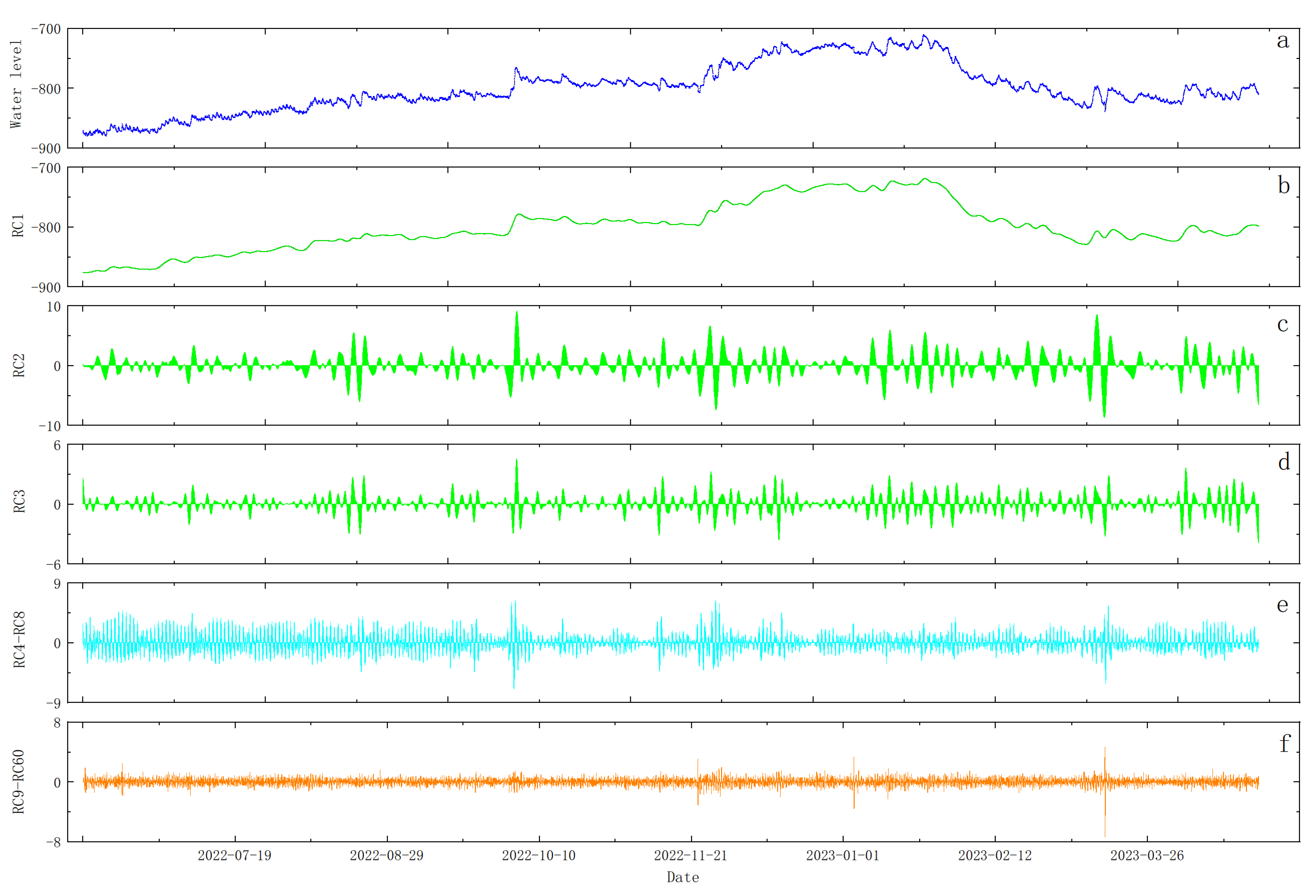
The undergroundwater level was decomposed using SSA to obtain reconstructed components (Figure 7), and the corresponding frequency information was obtained through Fourier transformation (Figure 5). The results showed that RC1–RC3 mainly represented low-frequency information, with RC1 being the main trend component. RC2 and RC3 exhibited similar curve variations, seemingly related to specific events. They showed significant amplitude changes during periods of heavy rainfall and cessation or resumption of underground brine extraction. RC4 and RC5 frequencies represented a 12 h cycle, while RC6–RC8 represented a 24 h cycle component. Furthermore, the spectral information of RC4–RC8 not only resembled the corresponding frequencies of tidal level but also clearly showed the small differences caused by different tidal constituents. This indicates that RC4–RC8 represents the influence of tidal action on the groundwater level, and the consistency of frequency details further demonstrates the effectiveness of the reconstructed components.
The maximum value of the combined RC4–RC8 component is 6.46 cm, while the minimum value is −7.06 cm. The maximum tidal amplitude is 71.3 cm, and the minimum is −50.2 cm. The amplitude of groundwater level changes caused by tidal fluctuations is approximately 11% of the tidal fluctuations, accounting for less than 8% of the maximum water level variation during the observation period. This is lower than the maximum rainfall of 36% and significantly lower than the 73% caused by underground brine extraction.

5. Conclusions

The Laizhou Bay region is the major brine chemical industry area in China. The long-term and high-intensity underground brine extraction has led to the gradual depletion of brine resources, and also caused changes in the groundwater flow field. This study utilized time series analysis to investigate the impact of brine extraction, tidal fluctuations, and precipitation on the groundwater level in the Laizhou Bay region.
The extraction of underground brine is a major factor in controlling changes in groundwater levels. Ceasing and resuming brine extraction can cause drastic changes in groundwater level, reaching 55% and 73% of the maximum changes in water level during the observation period, respectively. The production cycle of raw salt can also cause significant fluctuations in groundwater levels, with jumps of 20 cm occurring during the peak and off-peak seasons of production.
Rainfall is also an important factor in the fluctuation of groundwater level. In addition to cumulative rainfall, different rainfall patterns can also have an impact on the rise in groundwater level, especially in the case of short-term heavy rainfall. Typical heavy rainfall can cause a 61.2 cm increase in groundwater level, reaching 36% of the maximum change in water level during the observation period.
The study area is located in a coastal region where the influence of tidal level on groundwater levels is an important factor to consider. By applying singular spectrum analysis to the groundwater levels, the tidal impact component was assessed. The amplitude of groundwater level variations caused by tidal fluctuations is approximately 11% of the tidal wave itself, accounting for less than 8% of the maximum observed water level change during the monitoring period. This value is significantly lower than the 73% attributed to underground brine extraction.

Author Contributions

Conceptualization, Q.S. and Y.Y.; methodology, Q.S.; software, B.C.; validation, Q.S., L.Y. and T.F.; formal analysis, W.L. (Wenquan Liu); investigation, G.C.; resources, Q.S.; data curation, W.L. (Wenzhe Lyu); writing—original draft preparation, Q.S.; writing—review and editing, Y.Y.; visualization, B.C.; supervision, Q.S.; project administration, Y.Y.; funding acquisition, Q.S. All authors have read and agreed to the published version of the manuscript.

Funding

This research was funded by the Basic Scientific Fund for National Public Research Institutes of China (GY0220Q03), the National Natural Science Foundation of China (42176213;42276223), and Shandong Natural Science Foundation (ZR2020MD078).

Institutional Review Board Statement

Not applicable.

Informed Consent Statement

Not applicable.

Data Availability Statement

The data used in this paper are available from the corresponding author upon reasonable request.

Acknowledgments

The authors give their most sincere thanks to the editors and reviewers for their contributions to the improvement of this article, and also thank the support of “observation and research station of seawater intrusion and soil salinization, Laizhou Bay”.

Conflicts of Interest

The authors declare no conflict of interest.

References

  1. Razzaq, A.; Liu, H.; Xiao, M.; Mehmood, K.; Shahzad, M.A.; Zhou, Y. Analyzing past and future trends in Pakistan’s groundwater irrigation development: Implications for environmental sustainability and food security. Envrion. Sci. Pollut. Res. 2023, 30, 35413–35429. [Google Scholar] [CrossRef]
  2. Abbas, A.; Waseem, M.; Ullah, W.; Zhao, C.; Zhu, J. Spatiotemporal Analysis of Meteorological and Hydrological Droughts and Their Propagations. Water 2021, 13, 2237. [Google Scholar] [CrossRef]
  3. Zou, J.; Xie, Z.; Yu, Y.; Zhan, C.; Sun, Q. Climatic responses to anthropogenic groundwater exploitation: A case study of the Haihe River Basin, Northern China. Clim. Dyn. 2014, 42, 2125–2145. [Google Scholar] [CrossRef]
  4. Alfarrah, N.; Walraevens, K. Groundwater Overexploitation and Seawater Intrusion in Coastal Areas of Arid and Semi-Arid Regions. Water 2018, 10, 143. [Google Scholar] [CrossRef]
  5. Ma, J.; Zhou, Z.; Guo, Q.; Zhu, S.; Dai, Y.; Shen, Q. Spatial Characterization of Seawater Intrusion in a Coastal Aquifer of Northeast Liaodong Bay, China. Sustainability 2019, 11, 7013. [Google Scholar] [CrossRef]
  6. Cao, T.; Han, D.; Song, X. Past, present, and future of global seawater intrusion research: A bibliometric analysis. J. Hydrol. 2021, 603, 126844. [Google Scholar] [CrossRef]
  7. Samani, S.; Moghaddam, A.A. Hydrogeochemical characteristics and origin of salinity in Ajabshir aquifer, East Azerbaijan, Iran. Q. J. Eng. Geol. Hydrogeol. 2015, 48, 175–189. [Google Scholar] [CrossRef]
  8. Zhang, X.; Dong, F.; Chen, G.; Dai, Z. Advance prediction of coastal groundwater levels with temporal convolutional and long short-term memory networks. Hydrol. Earth Syst. Sci. 2023, 27, 83–96. [Google Scholar] [CrossRef]
  9. Singaraja, C.; Chidambaram, S.; Jacob, N. A study on the influence of tides on the water table conditions of the shallow coastal aquifers. Appl. Water Sci. 2018, 8, 11. [Google Scholar] [CrossRef]
  10. Li, H.; Jiao, J.J. Review of Analytical Studies of Tidal Groundwater Flow in Coastal Aquifer Systems. In Proceedings of the International Symposium on Water Resources and the Urban Environment, Wuhan, China, 9–10 November 2003. [Google Scholar]
  11. Tularam, G.A.; Keeler, H.P. The study of coastal groundwater depth and salinity variation using time-series analysis. Environ. Impact Assess. 2006, 26, 633–642. [Google Scholar] [CrossRef]
  12. Dong, L.; Chen, J.; Fu, C.; Jiang, H. Analysis of groundwater-level fluctuation in a coastal confined aquifer induced by sea-level variation. Hydrogeol. J. 2012, 20, 719–726. [Google Scholar] [CrossRef]
  13. Hussain, F.; Wu, R.; Shih, D. Water table response to rainfall and groundwater simulation using physics-based numerical model: WASH123D. J. Hydrol. Reg. Stud. 2022, 39, 100988. [Google Scholar] [CrossRef]
  14. Hoover, D.J.; Odigie, K.O.; Swarzenski, P.W.; Barnard, P. Sea-level rise and coastal groundwater inundation and shoaling at select sites in California, USA. J. Hydrol. Reg. Stud. 2017, 11, 234–249. [Google Scholar] [CrossRef]
  15. Yang, F.; Jia, C.; Chang, W.; Yang, H.; Wang, C.; Fan, Q. Integrating hydrochemical and microbial methods to identify hydraulic connections between three saltworks in southern Laizhou Bay, China. Hydrogeol. J. 2022, 30, 1847–1862. [Google Scholar] [CrossRef]
  16. McLin, S. Spectral analysis of observed aquifer water level fluctuations. Comput. Geosci. 2012, 46, 264–271. [Google Scholar] [CrossRef]
  17. Han, D.; Kohfahl, C.; Song, X.; Xiao, G.; Yang, J. Geochemical and isotopic evidence for palaeo-seawater intrusion into the south coast aquifer of Laizhou Bay, China. Appl. Geochem. 2011, 26, 863–883. [Google Scholar] [CrossRef]
  18. Liu, S.; Tang, Z.; Gao, M.; Hou, G. Evolutionary process of saline-water intrusion in Holocene and Late Pleistocene groundwater in southern Laizhou Bay. Sci. Total Environ. 2017, 607, 586–599. [Google Scholar] [CrossRef]
  19. Han, Y.; Meng, G.; Wang, S. A preliminary study on the distribution and genesis of underground brine in the littoral plain of Laizhou Bay in the Bohai Sea. Chin. J. Oceanol. Limnol. 1993, 11, 46–56. [Google Scholar]
  20. Han, D.M.; Song, X.F.; Currell, M.J.; Yang, J.L.; Xiao, G.Q. Chemical and isotopic constraints on evolution of groundwater salinization in the coastal plain aquifer of Laizhou Bay, China. J. Hydrol. 2014, 508, 12–27. [Google Scholar] [CrossRef]
  21. He, L.; Xue, C.; Ye, S.; Laws, E.A.; Yuan, H.; Yang, S.; Du, X. Holocene evolution of the Liaohe Delta, a tide-dominated delta formed by multiple rivers in Northeast China. J. Asian Earth Sci. 2018, 152, 52–68. [Google Scholar] [CrossRef]
  22. Vann, S.; Puttiwongrak, A.; Suteerasak, T.; Koedsin, W. Delineation of Seawater Intrusion Using Geo-Electrical Survey in a Coastal Aquifer of Kamala Beach, Phuket, Thailand. Water 2020, 12, 506. [Google Scholar] [CrossRef]
  23. Smith, A.; Lott, N.; Vose, R. The Integrated Surface Database: Recent Developments and Partnerships. Bull. Am. Meteorol. Soc. 2011, 92, 704–708. [Google Scholar] [CrossRef]
  24. NAMIAS, V. The Fractional Order Fourier Transform and its Application to Quantum Mechanics. IMA J. Appl. Math. 1980, 25, 241–265. [Google Scholar] [CrossRef]
  25. Kendall, A.D.; Hyndman, D.W.; Hyndman, D.W.; Day Lewis, F.D.; Hyndman, D.W.; Singha, K.; Day-Lewis, F.D.; Singha, K. Examining watershed processes using spectral analysis methods including the scaled-windowed Fourier transform. Geophys. Monogr. 2007, 171, 183–200. [Google Scholar]
  26. Acworth, R.I.; Rau, G.C.; McCallum, A.M.; Andersen, M.S.; Cuthbert, M.O. Understanding connected surface-water/groundwater systems using Fourier analysis of daily and sub-daily head fluctuations. Hydrogeol. J. 2015, 23, 143–159. [Google Scholar] [CrossRef]
  27. Fleming, S.W.; Marsh Lavenue, A.; Aly, A.H.; Adams, A. Practical applications of spectral analysis to hydrologic time series. Hydrol. Process. 2002, 16, 565–574. [Google Scholar] [CrossRef]
  28. Moosavi, V.; Vafakhah, M.; Shirmohammadi, B.; Behnia, N. A Wavelet-ANFIS Hybrid Model for Groundwater Level Forecasting for Different Prediction Periods. Water Resour. Manag. 2013, 27, 1301–1321. [Google Scholar] [CrossRef]
  29. Muchebve, E.; Nakamura, Y.; Suzuki, T.; Kamiya, H. Analysis of the dynamic characteristics of seawater intrusion using partial wavelet coherence: A case study at Nakaura Watergate, Japan. Stoch. Environ. Res. Risk Assess. 2016, 30, 2143–2154. [Google Scholar] [CrossRef]
  30. Biswas, A.; Si, B.C. Identifying scale specific controls of soil water storage in a hummocky landscape using wavelet coherency. Geoderma 2011, 165, 50–59. [Google Scholar] [CrossRef]
  31. Li, M.; Hinnov, L.; Kump, L. Acycle: Time-series analysis software for paleoclimate research and education. Comput. Geosci. 2019, 127, 12–22. [Google Scholar] [CrossRef]
  32. Torrence, C.; Compo, G.P. A Practical Guide to Wavelet Analysis. Bull. Am. Meteorol. Soc. 1998, 79, 61–78. [Google Scholar] [CrossRef]
  33. Hassani, H. Singular Spectrum Analysis: Methodology and Comparison. J. Data Sci. 2021, 5, 239–257. [Google Scholar] [CrossRef]
  34. Jalón-Rojas, I.; Schmidt, S.; Sottolichio, A. Evaluation of spectral methods for high-frequency multiannual time series in coastal transitional waters: Advantages of combined analyses. Limnol. Oceanogr. Methods 2016, 14, 381–396. [Google Scholar] [CrossRef]
  35. Carreira, P.M.; Marques, J.M.; Nunes, D. Source of groundwater salinity in coastline aquifers based on environmental isotopes (Portugal): Natural vs. human interference. A review and reinterpretation. Appl. Geochem. 2014, 41, 163–175. [Google Scholar] [CrossRef]
  36. Golyandina, N.; Korobeynikov, A. Basic Singular Spectrum Analysis and forecasting with R. Comput. Stat. Data Anal. 2014, 71, 934–954. [Google Scholar] [CrossRef]
  37. Taylor, S.J.; Letham, B. Forecasting at Scale. Am. Stat. 2018, 72, 37–45. [Google Scholar] [CrossRef]
  38. Nasri, B.; Bouezmarni, T.; St-Hilaire, A.; Ouarda, T.B.M.J. Non-stationary hydrologic frequency analysis using B-spline quantile regression. J. Hydrol. 2017, 554, 532–544. [Google Scholar] [CrossRef]
  39. You, Z.; Chen, C. 7–Coastal Dynamics and Sediment Resuspension in Laizhou Bay. In Sediment Dynamics of Chinese Muddy Coasts and Estuaries; Wang, X.H., Ed.; Academic Press: San Diego, CA, USA, 2019; pp. 123–142. [Google Scholar]
  40. Pan, H.; Lv, X.; Wang, Y.; Matte, P.; Chen, H. Exploration of Tidal-Fluvial Interaction in the Columbia River Estuary Using S_TIDE. J. Geophys. Res. Ocean. 2018, 123, 6598–6619. [Google Scholar] [CrossRef]
  41. Shih, D.C.F.; Lin, G.F. Spectral analysis of water level fluctuations in aquifers. Stoch. Environ. Res. Risk Assess. 2002, 16, 374–398. [Google Scholar] [CrossRef]
  42. Cai, S.; Liu, L.; Wang, G. Short-term tidal level prediction using normal time-frequency transform. Ocean. Eng. 2018, 156, 489–499. [Google Scholar] [CrossRef]
  43. Vautard, R.; Ghil, M. Singular spectrum analysis in nonlinear dynamics, with applications to paleoclimatic time series. Phys. D Nonlinear Phenom. 1989, 35, 395–424. [Google Scholar] [CrossRef]
  44. Yang, F.; Liu, S.; Jia, C.; Gao, M.; Chang, W.; Wang, Y. Hydrochemical characteristics and functions of groundwater in southern Laizhou Bay based on the multivariate statistical analysis approach. Estuar. Coast. Shelf Sci. 2021, 250, 107153. [Google Scholar] [CrossRef]
  45. Yu, X.; Xin, P.; Lu, C.; Robinson, C.; Li, L.; Barry, D.A. Effects of episodic rainfall on a subterranean estuary. Water Resour. Res. 2017, 53, 5774–5787. [Google Scholar] [CrossRef]
  46. Zhang, D.; Wang, H.; Zhang, X.; Ma, Q. Design and analysis of raw brine supply of 2000 t/a bromine extraction in north sea–salt area. J. Salt Chem. Ind. 2016, 45, 36–38. (In Chinese) [Google Scholar]
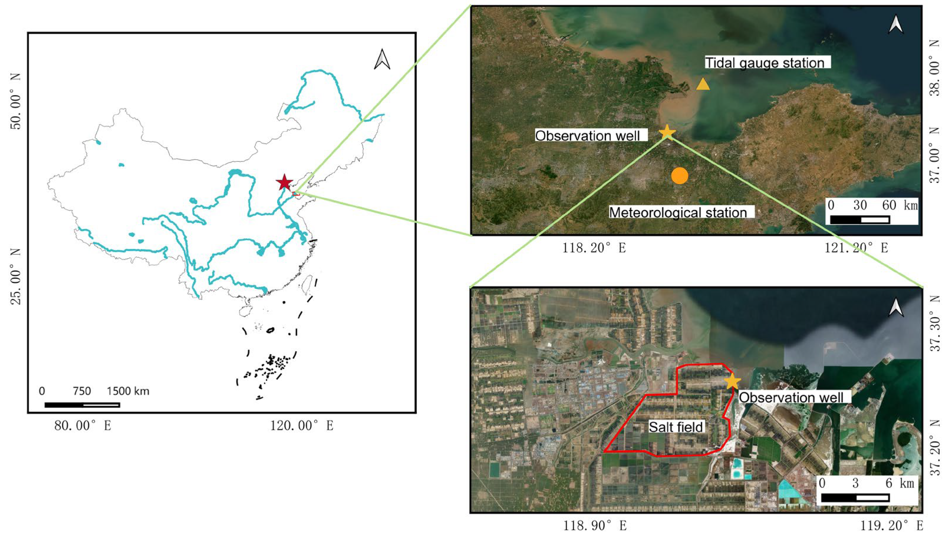
Figure 1. Location of the study area and distribution of observation stations.
Sustainability 15 16199 g001
Figure 2. Observations and frequency analysis of groundwater level, tidal level, and rainfall.
Sustainability 15 16199 g002
Figure 3. Wavelet coherence between groundwater level and tidal level.
Sustainability 15 16199 g003
Figure 4. Matrix of w-correlations for the reconstructed components.
Sustainability 15 16199 g004
Figure 5. The frequency of reconstruction components. (ah) represent the amplitude-frequency plots of RC1–RC8, respectively.
Sustainability 15 16199 g005
Figure 6. Prediction value of groundwater level for brine cessation and resumption of mining.
Sustainability 15 16199 g006
Figure 7. The reconstruction components of water level. (a) represents the water level of the observation well, (bd) represent the first three reconstruction components, respectively. (e) represents the sum of RC4–RC8, while (f) represents the sum of RC9–RC60.
Sustainability 15 16199 g007
Disclaimer/Publisher’s Note: The statements, opinions and data contained in all publications are solely those of the individual author(s) and contributor(s) and not of MDPI and/or the editor(s). MDPI and/or the editor(s) disclaim responsibility for any injury to people or property resulting from any ideas, methods, instructions or products referred to in the content.