Abstract
Bangkok, the capital of Thailand, grapples with several urban challenges, including traffic accidents, congestion, and underdeveloped sidewalks. These issues stem from the escalating use of private cars and motorcycles driven by rapid urbanization, accompanying economic growth, and the unique street geometry of the city. Furthermore, despite the development of railroads, issues persist with the poor walking environment for pedestrian access to stations, posing a challenge to the promotion of safe and environmentally friendly public transportation. This study evaluated streets’ spatial performance, focusing on the performance of soi, the intricate network of narrow urban pathways in Bangkok. Leveraging an AI model capturing pedestrian value, this study subsequently assessed accessibility from typical residential areas to public transportation stations. The findings shed light on the challenges faced by sois in Bangkok. Based on the findings, practical implications were discussed and provided to inform urban designers, with the aim of promoting public transportation usage and encouraging a more sustainable urban form.
1. Introduction
In recent years, rapid urbanization and dramatic economic growth in Bangkok have led to explosive growth in motorization, resulting in issues such as traffic accidents and congestion [1]. Although railway development is progressing [2], the city’s unique urban structure and impractical sidewalks present challenges for pedestrians seeking access to stations, impeding the promotion of safe and environmentally friendly public transportation options [3]. Bangkok’s distinctive urban structure comprises superblocks measuring 2–4 km by 2–4 km. The road network is delineated by trunk roads called “thanon” and smaller residential roads referred to as “soi” in Thai, resembling fish bones [4]. These sois, branching off major roads (thanon), extend into central blocks. Originally utilized as waterways, many sois now function as dead-end roads, varying in length from short meters to several kilometers, such as Sukhumvit Street and Phahon Yothin Street [5]. Within the superblocks, sois run parallel. To travel from a residential area situated in the center of a superblock to another soi or to exit the area, residents must exit once to the thanon. This results in a notable disparity between the straight-line distance to the destination and the actual distance of the shortest route. Additionally, the presence of numerous street vendors and motorcycle parking contributes to chronic traffic congestion. The streets further face challenges such as poor road surface quality and elevated sidewalks designed for flood control. Consequently, the walking conditions on the streets of Bangkok are deemed inadequate [6,7].
The importance of enhancing the pedestrian environment is underscored by international initiatives. Specifically, the rising concern for sustainable cities has heightened the focus on urban planning that is pedestrian-friendly and conducive to walking [8,9,10,11]. The significance of dynamic urban planning to address diverse risks, including natural disasters and pandemics, has also garnered attention. As a result, there is a growing need for insights into the walkability and accessibility of cities through walking and public transportation [12,13].
In Thailand, the government has embraced a novel initiative known as “Thailand 4.0” [14], designed to foster emerging industries such as next-generation mobilities and smart technologies [15]. The overarching goal is to build smart cities that leverage advanced technologies, including AI, to enhance environmental sustainability and the quality of life (QoL) of its citizens. In pursuit of this vision, a collaborative research project between Thailand, JICA, and JST is underway [16]. As part of this initiative, an intelligent transportation strategy named the “Sukhumvit Model” is developed in the congested Vadhana district, located at the center of Bangkok. The proposed strategy is driven by twin objectives: enhancing the QoL for citizens and establishing a low-carbon society, incorporating measures such as traffic simulation, the introduction of shared small-format mobility options, and improvements to the walkability within the Sukhumvit area [16].
In the urban landscape of Bangkok, the spatial performance of small and medium-sized streets plays a pivotal role in shaping the pedestrian experience, connecting with local communities, and contributing to sustainable neighborhood development. This study represents a significant advancement in the assessment of street spaces through the innovative integration of AI and Human Cooperative Evaluation (AIHCE). The AIHCE method, a deep learning-based street space evaluation developed by the authors [17,18], leverages labeled image data to infer spatial impressions, providing a nuanced understanding of street environments. Building upon our previous work in AI-based evaluation, which was confined to road cross-sections and segments, this study extends its scope to encompass entire road networks. What sets this research apart is the introduction of a novel distance index that considers spatial performance, coupled with a pioneering method to assess street spatial performance at the network level. This expansion offers a comprehensive analysis that goes beyond individual road elements.
The proposed method allows for a holistic evaluation of street spaces within the context of superblocks, a prevalent feature in Bangkok. Our approach not only advances the understanding of street configurations but also provides insights into the accessibility and safety of walking to public transportation. By delving into the intricacies of street networks, this study seeks to uncover valuable information that has the potential to significantly impact urban planning and design, steering it towards more pedestrian-friendly and sustainable practices.
The structure of this paper is as follows: Section 2 reviews the relevant studies focusing on walkability evaluation methods and the walking environment in Bangkok. Section 3 describes the methodology used in this study and the selection of the study site. Section 4 presents the results. Section 5 discusses the findings and implications based on the results. Section 6 concludes the paper with remarks on the significance, limitations, and future research direction.
2. Literature Review
2.1. Evaluating the Walkability of Streets
Walking is considered a sustainable mode of transportation that contributes to people’s health, well-being, and the maintenance of physical activity. Moreover, walkability has been demonstrated to impact sustainability from economic, social, and environmental perspectives. In other words, it not only enhances health and social equity but also reduces greenhouse gas emissions [19,20].
Numerous definitions of walkability have been proposed. Most interpretations emphasize the ease of access to destinations and proximity, considering land use and routes. These definitions predominantly focus on physical environmental factors like sidewalk width, the number of traffic lanes, safe speeds, connectivity, intersections, and pedestrian service levels [21,22,23,24,25,26]. Additionally, walkability is also characterized by comfort during walking, encompassing psychological and environmental factors. These factors involve elements such as the presence of greenery and water, cleanliness, traffic volume, aesthetically pleasing buildings, vegetation, lighting, and a sense of security [27,28,29,30,31,32].
There are also varying perspectives when evaluating the level of walkability. For subjective evaluation, common methods include questionnaires and interviews to gauge pedestrians’ subjective perceptions of the built environment [33,34,35,36,37]. Gorrini et al. conducted a qualitative walkability assessment of Venice’s historic center by utilizing open data from public agencies and on-site observations, revealing that a lack of essential services, tourist crowds, and insufficient signage affect walkability [38]. Millington et al. demonstrated that the Scottish Walkability Assessment Tool (SWAT), designed to objectively record physical environment aspects related to walking in Scottish urban areas, can potentially assess walkability [39].
Geographic Information Systems (GIS) are used as an effective tool for objective assessment [40,41,42,43]. Especially in the field of urban planning, many studies have employed GIS and geodatabases to assess walkability, involving measures such as neighborhood connectivity, housing density, land use, proximity, etc. [24,44,45,46,47,48,49]. In Frank et al.’s study, walkability was quantified and assessed using indices based on land use, net residential density, intersection density, street connectivity, and retail floor area ratio [50,51]. Regarding environmental factors that significantly influence walkability, a recent study conducted by Isinkaralar [52] focused on outdoor thermal comfort under various climate change scenarios. The study employed spatial and temporal modeling through GIS to delineate bioclimatic comfort areas.
Some studies have incorporated the Walk Score service [53] into their walkability assessments, which score facilities within a 1-mile (1.6-km) radius. Carr et al. showed a significant correlation between Walk Score and multiple objective-built environment measures of physical activity, including connectivity, residential density, and access to transit [54]. Despite limited empirical evidence on the Walk Score’s potential to estimate neighborhood walkability, Duncan et al. explored its utility and applicability in the field of public health research. The Walk Score is suggested as a valid substitute for specific neighborhood walkability indicators such as retail destinations, intersection density, and population density [55]. In a unique approach, Otsuka et al. introduced a modified version of the Walk Score to evaluate walkability specifically concerning access to railway stations in urban areas. The walkability indicators are based on four key criteria: urban form, street design, obstacles, traffic safety, and personal perception. The adapted method employs a point deduction system for traffic-related obstacles, including factors such as traffic noise, pedestrian casualties, road speed limits, and air quality [32]. However, it is crucial to note that Walk Score is currently available only in some cities in America, the UK, Canada, and Australia. Sou et al. have developed an image recognition technique based on deep learning to evaluate the walkability and lingerability of streets [17,18]. This facilitates the continual and objective evaluation of street space.
As demonstrated above, numerous walkability assessment methods have been proposed, each providing a distinct definition of walkability.
2.2. Streets and the Walking Situation in Bangkok
To promote walking to transit stations, pedestrian-friendly environments must be created with mixed land use and high population densities around stations. However, the widespread adoption of motorization has diminished walking as a prevalent mode of transportation. This shift is particularly pronounced in urban areas, as exemplified by cities such as Bangkok. Despite the expanding population in the vicinity of public transportation stations due to urban development, there is a noticeable reluctance to embrace walking as a daily commuting option. As a result, the use of rail services remains limited [56]. This trend underscores the necessity for targeted interventions and urban planning strategies focused on improving walkability, thereby contributing to the overall sustainability of the city.
Acceptable walking distances (AWDs) to public transit in Bangkok have been surveyed in several studies, revealing that the AWD in Bangkok’s tropical climate is shorter than in cities located in colder regions, resulting in lower walking frequency [56,57,58,59]. Chalermpong et al. showed that in Bangkok, the primary modes of accessing public transit are private cars, buses, or motorcycle taxis, with walking constituting only around 15% of the total share. Additionally, alternative green modes, such as bicycles, were found to be almost non-existent. The study also identified factors influencing walking access to transit stations, including not just walking distance but also considerations of comfort, physical characteristics, land use patterns, road network structure, and integration with other modes.
Walking in central Bangkok is challenging due to the absence of sidewalks, numerous obstacles, and poor surface quality [59]. Ozawa et al. used the Analytical Hierarchy Process (AHP) to quantify the importance (weight) of various road space elements. Their findings indicated that factors such as the presence of sidewalks, hazards, steps, obstacles, and road width significantly impact the walkability of Bangkok’s sidewalks. The conclusion drawn was that enhancing safety and comfort is important for improving walkability [60]. Pongprasert et al. suggested that many Bangkok residents do not find walking enjoyable when accessing stations, emphasizing that comfortable and cozy streets possess higher-order qualities than simply walkable streets [61]. To enhance the on-street experience, the study recommended the installation of eco-friendly small mobility services in areas where the access road quality is insufficient.
Building upon the findings from the literature, this study aims to evaluate the spatial performance of streets from pedestrians’ viewpoint, focusing on both walkability and the comfort of the street environment, particularly targeting the narrow residential streets known as soi in Thailand. Specifically, this study quantitatively assesses the subjective value measure of pedestrian comfort in urban spaces using deep learning. By evaluating pedestrian accessibility considering psychological resistance, we reevaluate the connectivity of residential streets and seek to provide insights for more effective utilization.
The evaluation results will be employed and analyzed to assess the level of accessibility from a typical residential area in Bangkok to nearby transit. The findings of this study help identify problems faced by soi, and potential improvement measures will be discussed to promote the use of public transit use as a means to encourage sustainable transport and urban development.
3. Methodology
3.1. AI-Based Street Evaluation
As discussed in the previous chapter, various methods have been proposed to evaluate the walkability of streets. Highlighted by Pongprasert et al. [61], the need to evaluate coziness and comfortability is particularly pertinent in the context of Bangkok. Common evaluation methods that delve into human values typically involve interviews and questionnaires. While effective, these approaches are known to be costly and time-consuming [62,63].
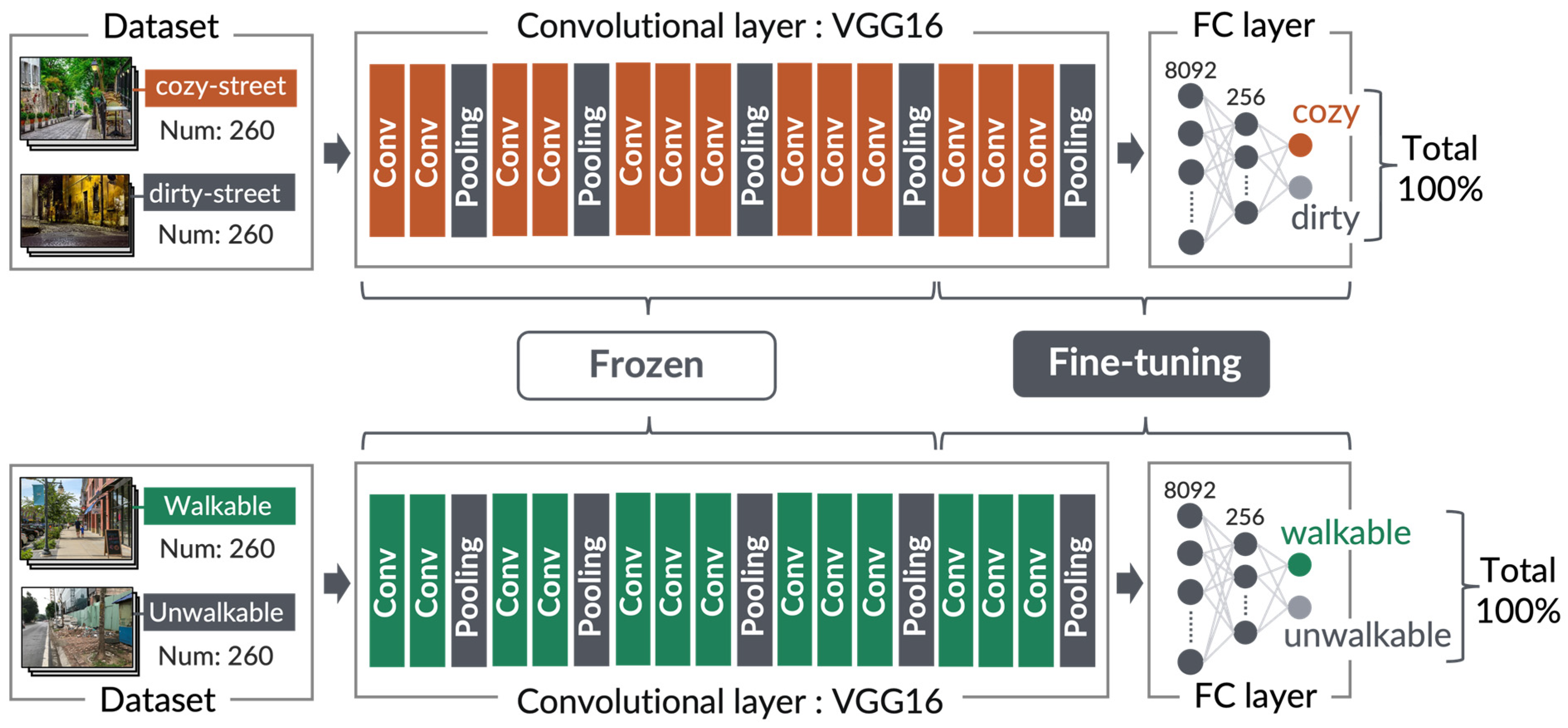
Conversely, image recognition methods based on deep learning have gained prominence across various fields in recent years. In urban planning, the application of Convolutional Neural Networks (CNN) to images of urban spaces has enabled the quantification of impressions related to the urban environment [64,65,66]. This study endeavors to evaluate street spaces, including value judgments, using CNN. To achieve this, this study employs AI and human co-operative evaluation (AIHCE), a street space evaluation method using deep learning developed by Sou et al. [17,18]. AIHCE consists of two evaluation methods. The first is the “street image evaluation model”, which directly assesses the impression of a space based on data labeled with the appearance of a street space. The second is the “facial expression recognition model”, which indirectly evaluates the street space by estimating emotions from the data of facial expressions during walking. In this study, the “street image evaluation model” was used.
The model incorporates two indices: walkability and lingerability, providing an assessment of the impression of a space based on street images. Sou et al. classified street space quality according to spatial performance on three hierarchical levels. The fundamental level involves usability and legibility. The intermediate level is walkability, indicating the capability to pass through space safely, smoothly, and comfortably. At the highest conceptual level is lingerability, defined as the performance that encompasses the comfort of lingering in space, allowing individuals to enjoy the enduring positive experience across time and space. The study asserts that enhancing lingerability, focusing on slow walking alongside walkability for passing through, is necessary for creating streetscapes that encourage walking and contribute to enhancing happiness. Evaluating both walkability and lingerability provides a comprehensive understanding of spatial performance [17,18]. Utilizing streetscape images, the image determination method evaluates street spatial performance through the suggested two indices: walkability and lingerability.
For the street image evaluation, the CNN model was trained on a dataset of street images with semantic labels collected from the internet [67]. In terms of linguistic labels, we set “walkable street” and “unwalkable street” to denote walkability, while “cozy street” and “dirty street” represented lingerability. Within the set of street image data, images that could not be identified as actual images of a walking space were removed. A total of 520 shots (260 for each keyword) were used as the training data (Table 1). The AI model was trained through fine-tuning using this dataset. Fine-tuning is a technique that achieves high accuracy even with a small number of training data. In this study, fine-tuning was conducted based on the pre-existing VGG16 learning model.

Table 1.
The data used for fine-tuning the model.
Fine-tuning involves relearning the weights of convolutional layers near the output layer by replacing the fully connected layer, which serves as the final output layer in the existing model. VGG16 [68] is a 16-layer model comprising 13 convolutional layers and three fully connected layers, known for robust feature representations across diverse image sets. The fully connected layers were reconfigured to classify streets into two categories based on walkability and lingerability indices. We fixed the weights of the first ten layers from the input side for the feature extractor, retraining only the three convolutional layers on the output side. By inputting the street images to be evaluated, the output provides the similarity to the trained street images as a probability (Figure 1). The probabilities output by the model were used as the WI (walkability index) and LI (lingerability index) of the streets, serving as indicators to evaluate spatial performance.

Figure 1.
Street Image Evaluation Model (SIEM) as part of AIHCE.
3.2. Input Data
The study area is the Sukhumvit area, situated in the Vadhana district of Bangkok, which is marked by severe traffic congestion (Figure 2). The Sukhumvit area, situated in the heart of Bangkok, is a typical location that is currently experiencing traffic issues such as congestion and accidents. As a central hub, it represents a prime example where problems arising from urbanization and motorization are already manifest. These challenges are expected to intensify with further urban and motorization expansion in the future. Consequently, this study focused on the Sukhumvit area, a single superblock where various transportation issues are already prevalent, conducting research to address these challenges proactively. The study area is encompassed by roads of varying lengths, measuring 1.3, 2.5, 3, and 3.1 km.
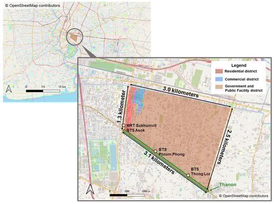
Figure 2.
Study area.
The surrounding thanon have high traffic volumes and are flanked by numerous commercial facilities, offices, and hotels. In contrast, upon entering the soi, there is a noticeable increase in residential areas. The southern end of the study area is anchored by Sukhumvit Road thanon, featuring the BTS Skytrain. In contrast, the western end is characterized by Asok Road thanon, accommodating the MRT underground.
The employed AI and human co-operative evaluation (AIHCE) adopts a dataset consisting of collected image data on a global scale. This approach aims to evaluate streets in diverse urban environments using consistent criteria. Given that the dataset incorporates information from diverse locations, including developing countries like Bangkok, it was employed for the evaluation in this study.
Firstly, we conducted a video camera survey, capturing footage while walking on all sidewalks and streets within the study area. The videos were recorded during two periods: from 19–28 August and 23–26 October 2022, spanning from 9:00 a.m. to 5:00 p.m. to ensure consistent sunlight conditions. The weather during these periods was either sunny or cloudy, taking into consideration the potential impact of darker images on recognition accuracy. Subsequently, the captured video images were segmented into one-second intervals. Finally, we fed this data into the AIHCE model, which generated continuous WI and LI for each street. The WI and LI values were aggregated by a street link, and the average value was utilized as the evaluation metric for street links.
4. Results
4.1. Results of Walkability Evaluation of Streets
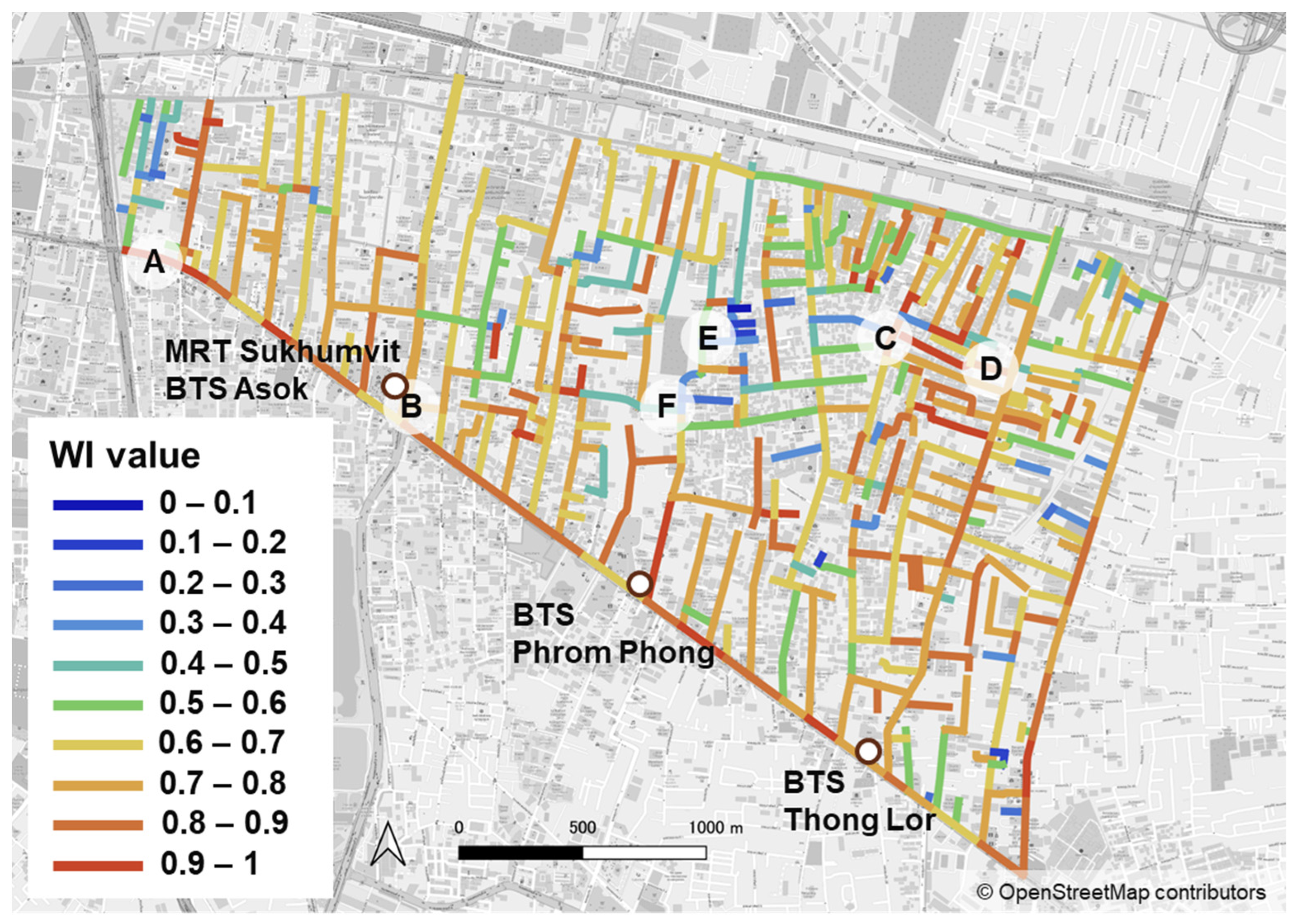
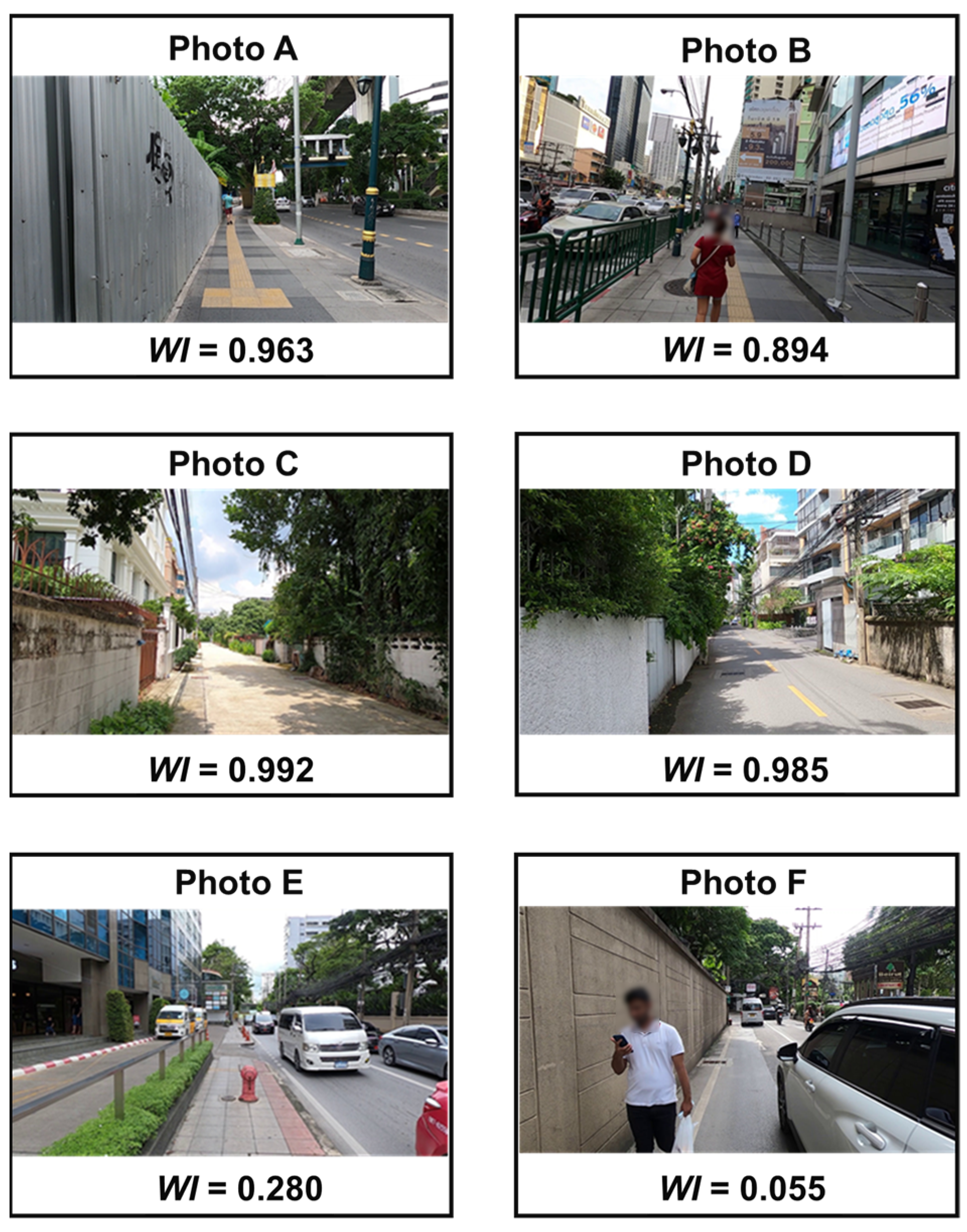
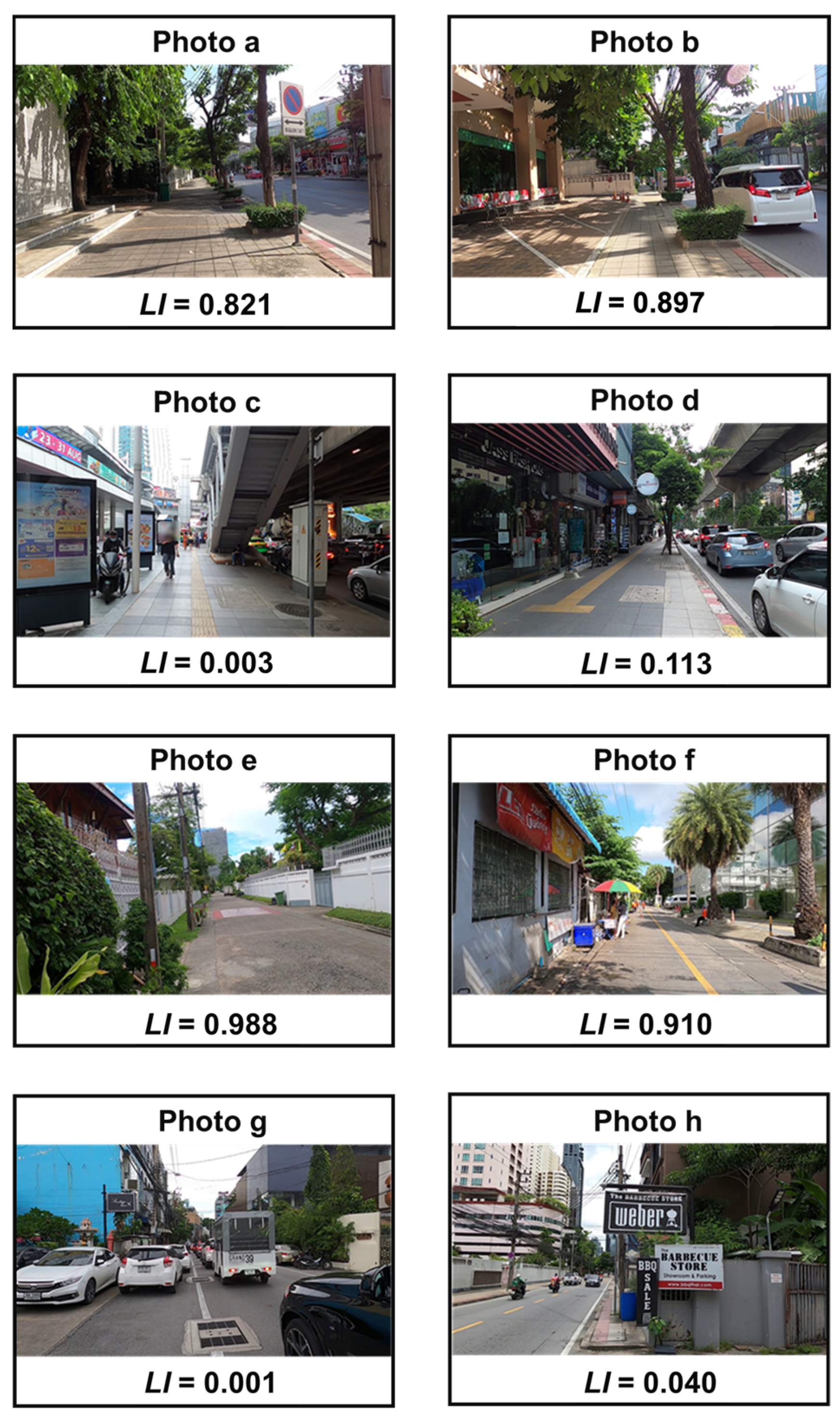
The WI of the streets in the target area was visualized on a map (Figure 3). The WI values were relatively high in thanon, which surrounds the area and forms a superblock, while low values were observed in the sois in the center of the area. To delve into this discrepancy, we examined images of areas with high WI values in the thanon (A, B), areas with high values at sois (C, D), and areas with low values at sois (E, F). Figure 4 shows the street images and their corresponding WI values, with the locations marked as A to F in Figure 3.
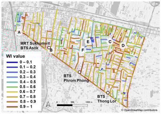
Figure 3.
Visualization of WI.

Figure 4.
Images of street space and WI value.
High WI values in thanon are exemplified by A, located on Sukhumvit Road, with a WI of 0.963, and B, located on Asoke Road, with a WI of 0.894. Both locations share common characteristics: wide sidewalks, absence of vendors on the sidewalks, and good visibility in the direction of travel. In addition, A features trees, while B offers a view of the sky above the direction of travel, potentially contributing to the higher WI. These factors were also identified in a previous study [17].
Turning to areas with high values at sois, we selected C and D, which have the highest WI among the residential areas. The selected sois, situated in the northeastern part of the target area, host a dense network of streets with relatively high WI ranging from 0.6 to 1.0. These areas, located at the end of the cul-de-sac, have no through traffic, low traffic volume, and non-existent sidewalks. The elevated WI in these locations is attributed to good visibility, greenery in the residential area, and free, relatively safe spaces for pedestrians.
Regarding locations with low WI values at sois, street views E and F were selected from the middle of the sois, which is the central part of the target area. The WI was relatively low at these locations, especially at the side street F connecting the sois. One reason for this is the heavy traffic volume in this area, with vehicles entering from connected sois causing occasional traffic congestion. Additionally, the absence of sidewalks, as seen in F, contributes to an unsafe and uncomfortable walking environment. On the other hand, in the case of E, although sidewalks are present, obstacles on the sidewalks contribute to a low WI. As described, in the central area of the target superblock, the WI is considered low due to insufficient space allocation for pedestrians.
4.2. Results of Lingerability Evaluation of Streets
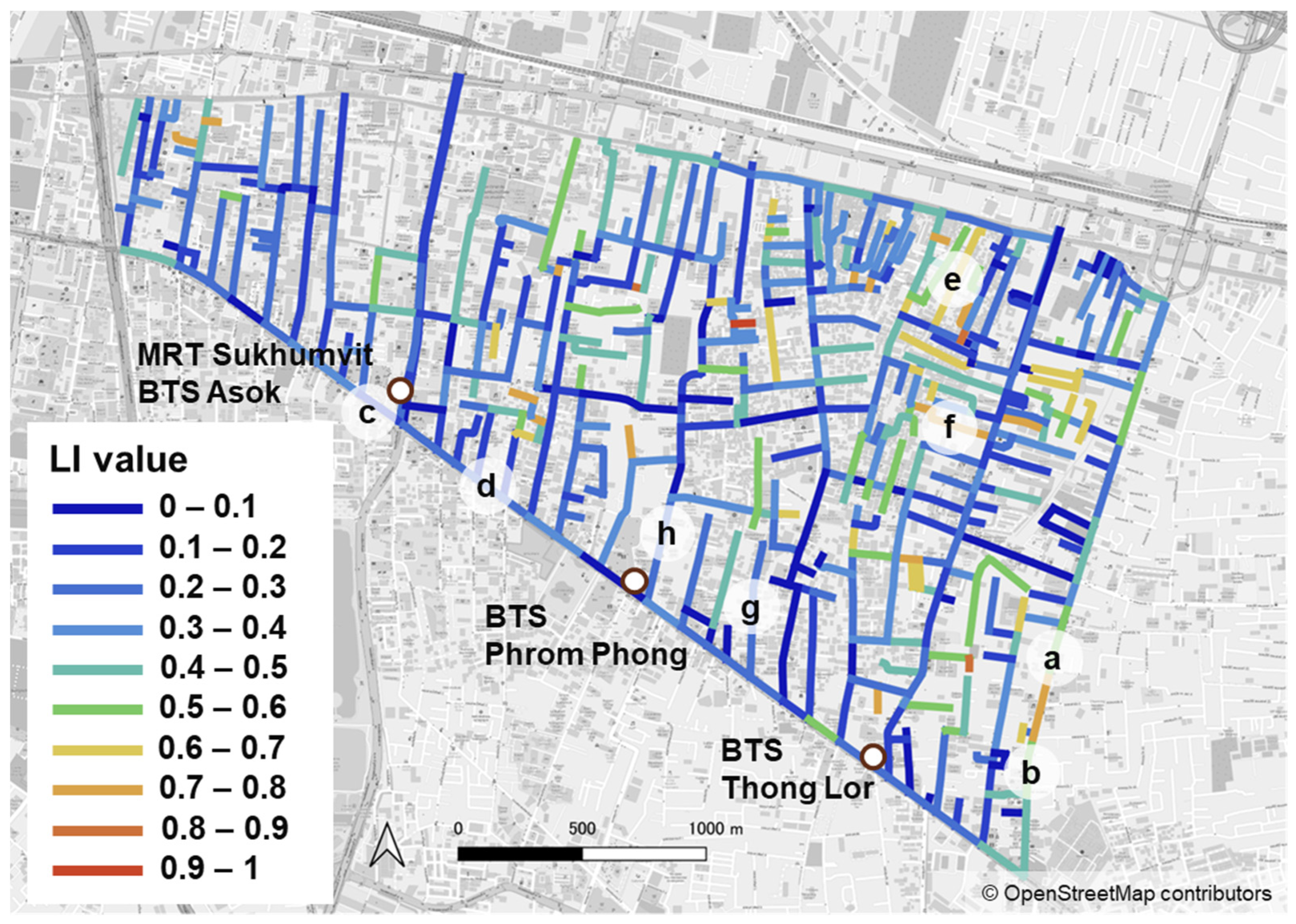
The LI of the streets in the target area was visualized (Figure 5), and in comparison to the WI, the LI values were generally smaller. To further examine this result, we scrutinized images of high (a, b) and low (c, d) LI values in thanon and high (e, f) and low (g, h) LI values in sois. Figure 6 shows images of the street space and LI values, with the locations marked as a to h in Figure 5.
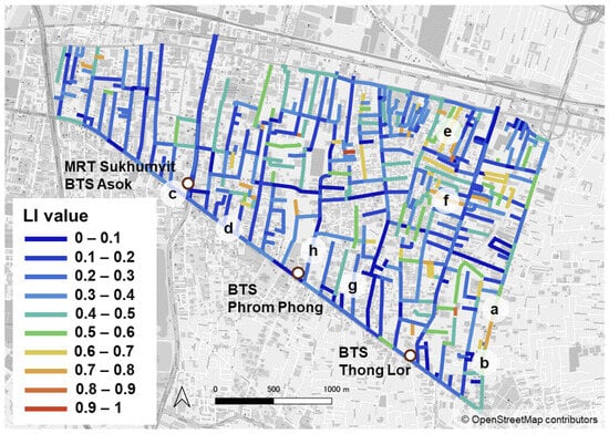
Figure 5.
Visualization of LI.

Figure 6.
Images of street space and LI value.
Images a and b were taken from Ekkamai Street at the east end of the target area, which has a relatively high LI value in thanon. As shown in both images, trees are planted along this street, the sidewalks are of a certain width, and in addition, there are few obstacles on the sidewalks, potentially influencing the high LI values. Low LI values in thanon were observed in c and d on Sukhumvit Road. In c, the presence of signboards and pedestrian bridge stairs on the sidewalks narrowed the space for pedestrians, and the lack of harmony between the road space and the roadside was considered to affect the low LI value. In the case of d, the low LI and the uncomfortable feeling are deemed to be caused by the lack of integration between natural and man-made elements, resulting from little planting and the unsuitability of the roadway as a place to stay due to the heavy traffic volume.
Conversely, the high LI areas in sois e and f were selected from the northeastern part of the area, characterized by a high concentration of streets with relatively high LI. These areas are situated at the end of sois from Sukhumvit Road. The high LI is thought to be influenced by the absence of passing traffic in this residential area, minimal traffic, limited on-street parking, and the presence of trees, providing a sense of unity with nature.
The low LI in sois g and h were examined. In g, there was a significant traffic flow entering and exiting thanon, accompanied by a lot of on-street parking. In h, the sidewalk was only about 1 m wide, and pillars and signboards further narrowed the walking space. Although there were two lanes in both locations, there was limited space for pedestrians. The pattern is consistent with the observation that the LI tends to be low on a relatively busy thanon side of the sois.
4.3. Spatial Performance of Streets
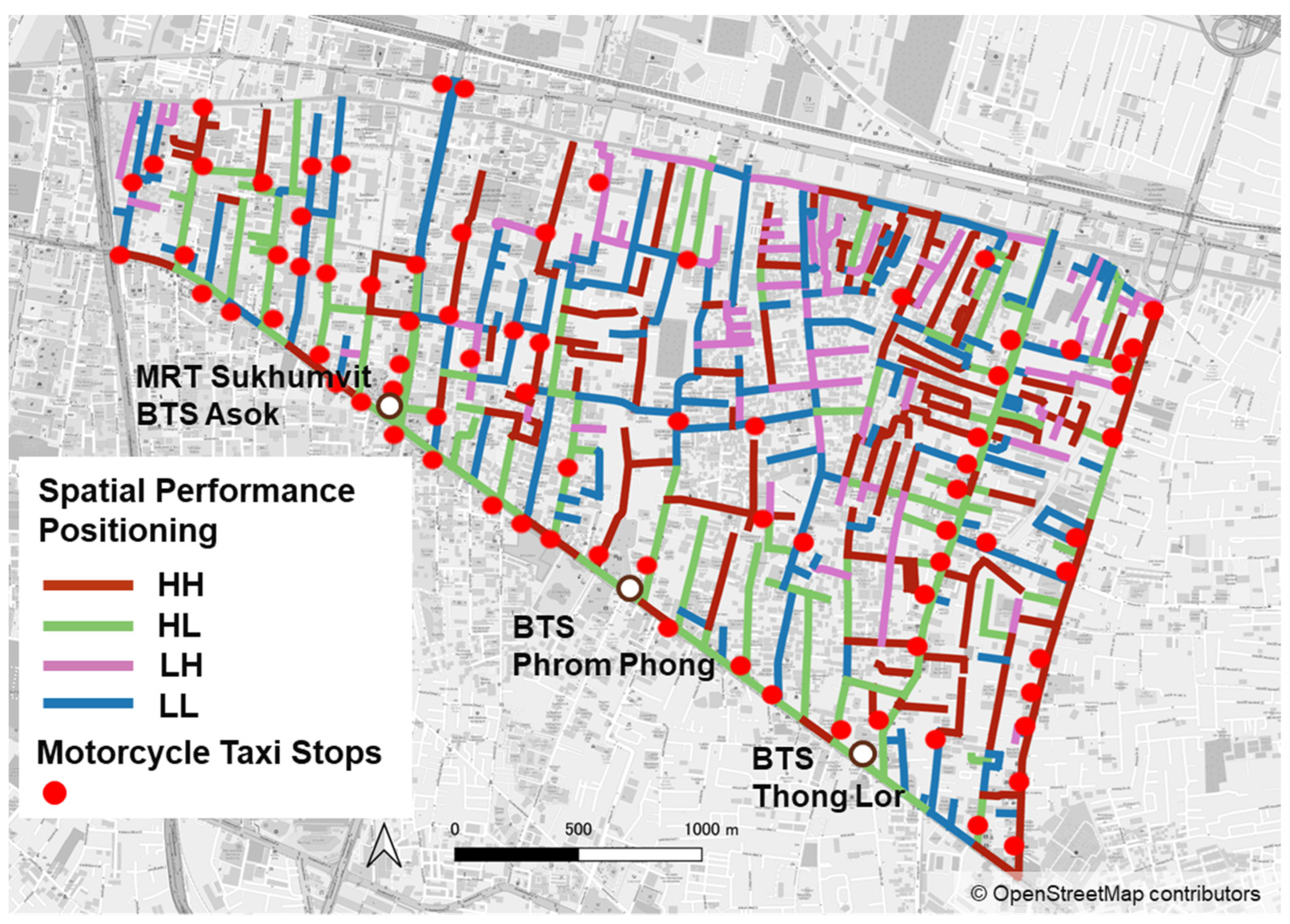
The streets’ spatial performance was evaluated by comprehensively assessing walkability and lingerability. The WI and LI values of street links were confirmed whether the values were above (High) or below (Low) average values, and the streets were classified into four categories: HH, HL, LH, and LL. The first letter indicates the WI and the second letter indicates the LI. The streets’ spatial performance is shown in Figure 7. The spatial performance in the deeper area from thanon is various. However, as there are few motorcycle taxi stops in the area, it can be anticipated that residents living along the low spatial performance streets would tend to use private vehicles for transit stations. On the other hand, most of the streets around transit stations are classified as HL, indicating that the sidewalks around the stations are relatively well maintained. However, it does not necessarily imply that people can walk comfortably, even though stations are expected to be a center of vitalization.
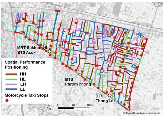
Figure 7.
Result of spatial performance evaluation.
5. Discussion
This study confirmed that most of the streets around the transit station are classified as high walkability and low lingerability (HL). Despite the relatively well-maintained sidewalks, the high traffic volume and obstacles present challenges for walking comfortably. These findings are consistent with the literature of Ozawa et al. [60], who highlighted the low level of walking comfort around train stations in urban areas of Bangkok.
Comfort is recognized to play an essential role in walking in Bangkok [69]. Therefore, to improve transportation accessibility, the focus should be on developing station areas with a primary emphasis on comfort.
5.1. Evaluation of Accessibility Considering Resistance Due to Streets’ Spatial Performance
5.1.1. Accessibility Considering Psychological Resistance
Based on the spatial performance evaluation described in the previous chapter, this chapter assesses accessibility, specifically the ease of walking access. It takes into account psychological resistance arising from walking in the residential area to the surrounding public transportation station. Considering the impact of streets’ spatial performance on walking resistance, the access distance was calculated using the following Equations (1) and (2). PsyD is the psychological distance considering walking difficulty, and HD represents the hedonic distance considering uncomfortableness.
where PhyD represents the physical distance of the shortest path in the street network consisting of links weighted by the inverse numbers of WI and LI.
To assess the accessibility to the public transportation station from residential areas, two apartment complexes, Residence H and Residence L, were selected. The residences represent areas with relatively high and low streets’ spatial performance within their surrounding area, respectively. The assigned public transportation stations in the study area include three transits (i.e., MRT Sukhumvit/BTS Asok, BTS Phrom Phong, and BTS Thong Lor) and 47 bus stops, while only one bus stop would be selected when multiple were in close proximity. The PsyD and HD from both Residences H and L to these stations were then calculated.
5.1.2. Evaluation Results and Issues on the Current Soi
The results of PhyD, PsyD, and HD from Residences L and H to the transit are shown in the upper part of Table 2. Although Phrom Phong station is the closest station to both residences, it is the second closest in terms of HD among the three transits. The HD/PhyD ratio was calculated to be the highest at Phrom Phong station.
Table 2.
The distance of the shortest path from residence to transit stations and bus stops.
The shortest distance from the residence to the bus stops was also calculated. The results of PhyD, PsyD, and HD for the three bus stops, which are physically closest to Residence L, are presented in the lower part of Table 2. Note that, regarding the bus stop names, the left side corresponds to Residence L, and the right side corresponds to Residence H. It is found that the bus stop named BTS Phrom Phong, which is physically closest to Residence L, is the seventh closest bus stop in the case of HD at the level of 11,852 m. For residence H, it is also found that the physically closest route to the bus stop and the closest route in PsyD, HD, are different.
The spatial performance of the area around Phrom Phong station was found to be the cause of these results, indicating a relatively poor walking environment. The images taken by the video surveys confirmed that obstacles such as traffic volume and on-street parking were the causes. The poor walking environment is thought to be a vicious cycle that makes people rely on cars, which in turn makes the walking environment even worse. Therefore, it is necessary to improve the accessibility of the streets around Phrom Phong station by enhancing the street spatial performance and then introducing new mobility options that have less impact on the environment.
Figure 8 shows the shortest routes from Residence L and Residence H to train stations, indicating that the shortest physical routes do not match most walkable paths. This is partly due to few access route patterns into the deep Sukhumvit area, with most soi functioning as vehicle space. Improving streets’ spatial performance is necessary to enhance the accessibility to public transportation.
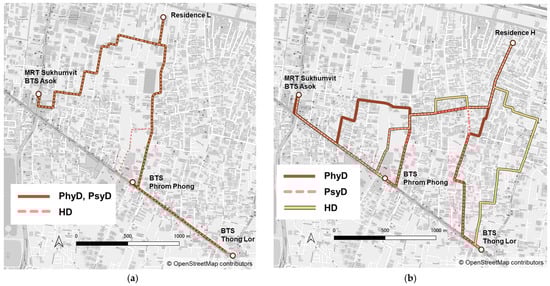
Figure 8.
Shortest route from the residence to the transit stations. (a) Shortest route from Residence L; (b) Shortest route from Residence H.
5.2. Consideration of Introducing Small Shared Mobility for Improved Accessibility
While acknowledging the current low spatial performance of soi and emphasizing the need to enhance pedestrian spaces, implementing large-scale development across extensive areas is challenging. One potential solution to address accessibility issues is the introduction of new small shared mobility options. In the urban setting of the Sukhumvit area, where collective residences often provide free shuttle services to stations, there is the opportunity and potential to optimize these services across residence facilities. However, the current shuttle buses, designed to accommodate many passengers, often operate with only a few passengers. Introducing small shared mobility options between residences could consolidate multiple underutilized shuttle buses into a single vehicle. This consolidation would not only alleviate congestion but also reduce road occupancy and carbon emissions.
To illustrate, consider implementing this approach at Phrom Phong station, an area where it is difficult to walk comfortably. Recognizing that limited shared vehicles could lead to extended wait times, a strategic solution involves establishing departure locations in low-evaluation areas and adding pickup spots along the route. This arrangement would allow residents in high-evaluation areas to walk to these pickup points, encouraging walking and fostering a more efficient and sustainable transportation and mobility system. As highlighted earlier, access routes into deep Sukhumvit are constrained, with most soi primarily serving as vehicle spaces. The adoption of small shared mobility could not only optimize vehicle occupancy but also diminish traffic volumes, subsequently freeing up road space for pedestrians and easing congestion.
6. Conclusions
This study evaluated the spatial performance of residential streets soi in the congested Sukhumvit area of Bangkok. Based on these results, this study assessed accessibility considering psychological resistance to walking from typical residences to public transit stations. Issues in soi from point and line perspectives were indicated, and improvement measures were considered. The main findings are as follows.
Using the AI model “AIHCE”, the streets’ spatial performance was evaluated based on walkability and lingerability indices. Motorcycle taxi stops in the target area were also surveyed. It showed areas where transportation options besides private cars are limited and where traffic and obstacles make it difficult to walk comfortably around the station.
Accessibility from typical residences to public transit stations was assessed as weighted shortest distances and routes on the street network, with links weighted by the walkability index (WI) and lingerability index (LI) inverse. The spatial performance around Phrom Phong station in the central Sukhumvit area was indicated to be worse than that of other stations due to traffic volumes and on-street parking. Limited access route patterns into the deep Sukhumvit area also meant that the shortest physical routes to transit stations did not necessarily match most walkable or comfortable paths.
To improve accessibility, this study considered the introduction of small shared mobility. It was indicated to reduce vehicle occupancy and traffic volume, provide space for pedestrians, and alleviate congestion. This could lead to increased public transit use, improved quality of life, and sustainable development.
Presently, traffic challenges in Bangkok encompass macro and micro factors, notably including the issues of extensive superblocks, a shortage of main thoroughfares, and a deficiency in auxiliary arterial roads. Additionally, identified issues in small and medium-sized streets may contribute to a high level of dependence on cars and two-wheeled transportation, even for short-distance travel in central Bangkok. Addressing these challenges requires a strategic overhaul of road structures and the hierarchical organization of streets to enhance the smoothness and safety of traffic [70]. This study evaluated the spatial performance and accessibility of the pedestrian space as the base of the street space and obtained knowledge for the effective use of small and medium-sized streets in Bangkok.
The limitations of this study are as follows: it focuses on public transportation stations, addressing only a segment of the intricate network of human mobility. By extending the evaluation to encompass accessibility to all services required by residents, in addition to transportation, comprehensive proposals for enhancing comfort could be formulated. In future research, a more comprehensive analysis of accessibility is imperative by scrutinizing the entire network of the Sukhumvit area.
Author Contributions
Conceptualization, Y.B., K.S. and K.D.; supervision, K.D. and K.Y.; methodology, Y.B. and K.S.; validation, K.Y., K.D. and C.-C.C.; data curation, K.S.; writing—original draft preparation, Y.B., K.S. and K.Y.; writing—review and editing; C.-C.C. All authors have read and agreed to the published version of the manuscript.
Funding
This research was funded by Science and Technology Research Partnership for Sustainable Development (SATREPS), grant number JPMJSA1704 (co-leaders: Yoshitsugu Hayashi and Thanaruk Theeramunkong).
Institutional Review Board Statement
Not applicable.
Informed Consent Statement
Not applicable.
Data Availability Statement
The data presented in this study are available on request from the corresponding author. The data are not publicly available due to privacy issues.
Conflicts of Interest
The authors declare no conflict of interest.
References
- WHO. WHO Global Status Report on Road Safety 2018; WHO: Geneva, Switzerland, 2018; p. 245. [Google Scholar]
- BTS Group Holdings PCL. Annual Report 2022/23 (FORM 56-1 ONE REPORT); BTS Group Holdings PCL: Bangkok, Thailand, 2023; pp. 36–40. [Google Scholar]
- Fukuda, A. Current Situation of Land Development in the Area along Rail Based Public Transport Systems in Bangkok—Limit and Possibility; IBS Annual Report; Kenkyu Katsudou Houkoku: Tokyo, Japan, 2017; pp. 71–76. [Google Scholar]
- Allison, G.H. Jumbo English-Thai Dictionary, 3rd ed.; Odeon Store: Bangkok, Thailand, 1978. [Google Scholar]
- Cohen, E. A soi in Bangkok: The dynamics of lateral urban expansion. J. Siam Soc. 1985, 73, 1–35. [Google Scholar]
- Watanabe, S.; Tsuboi, Y.; Akiyama, S.; Hoshihara, M.; Watanabe, Y. Study on characteristic of Urban street structure of Bangkok—A Relation of the Soi and Pakksoi in the Sukhumvit Area part1. Summ. Tech. Pap. Annu. Meet. Archit. Inst. Jpn. 2008, F-1, 969–970. [Google Scholar]
- Yingyeod, S. Soi Problem on the Rise. Bangkok Post 1971, 25, 7. [Google Scholar]
- Moreno, C.; Allam, Z.; Chabaud, D.; Gall, C.; Pratlong, F. Introducing the “15-Minute City”: Sustainability, Resilience and Place Identity in Future Post-Pandemic Cities. Smart Cities 2021, 4, 93–111. [Google Scholar] [CrossRef]
- Ulloa-Leon, F.; Correa-Parra, J.; Vergara-Perucich, F.; Cancino-Contreras, F.; Aguirre-Nuñez, C. “15-Minute City” and Elderly People: Thinking about Healthy Cities. Smart Cities 2023, 6, 1043–1058. [Google Scholar] [CrossRef]
- Khavarian-Garmsir, A.R.; Sharifi, A.; Hajian Hossein Abadi, M.; Moradi, Z. From Garden City to 15-Minute City: A Historical Perspective and Critical Assessment. Land 2023, 12, 512. [Google Scholar] [CrossRef]
- Eggimann, S. The potential of implementing superblocks for multifunctional street use in cities. Nat. Sustain. 2022, 5, 406–414. [Google Scholar] [CrossRef]
- Carra, M.; Rossetti, S.; Tiboni, M.; Vetturi, D. Urban regeneration effects on walkability scenarios. TeMA J. Land Use Mobil. Environ. 2022, 16, 101–114. [Google Scholar]
- Russo, A.; Campisi, T.; Tesoriere, G.; Annunziata, A.; Garau, C. Accessibility and Mobility in the Small Mountain Municipality of Zafferana Etnea (Sicily): Coupling of Walkability Assessment and Space Syntax. In Proceedings of the International Conference on Computational Science and Its Applications, Malaga, Spain, 4–7 July 2022; pp. 338–352. [Google Scholar]
- Thailand4.0—(thaiembdc.org). Available online: https://thaiembdc.org/thailand-4-0-2/ (accessed on 11 October 2023).
- Oizumi, K. “Thailand 4.0” toha nanika (zenpen)—Kouseityou-rosen ni kaji wo kiru Thai. Kan-Taiheiyou Bizinesu Zyouhou RIM 2017, 17, 91–103. [Google Scholar]
- The Project of Smart Transport Strategy for Thailand. Available online: https://www.jica.go.jp/project/thailand/034/index.html (accessed on 11 October 2023).
- Sou, K.; Kashima, S.; Yoh, K.; Doi, K. Evaluating the Performance of Walking Spaces Considering Passage and Retention Functions Using Image Recognition AI Model. J. Traffic Eng. 2022, 9, A_213–A_222. [Google Scholar]
- Sou, K.; Shiokawa, H.; Yoh, K.; Doi, K. Street Design for Hedonistic Sustainability through AI and Human Co-Operative Evaluation. Sustainability 2021, 13, 9066. [Google Scholar] [CrossRef]
- Baobeid, A.; Koç, M.; Al-Ghamdi, S.G. Walkability and Its Relationships with Health, Sustainability, and Livability: Elements of Physical Environment and Evaluation Frameworks. Front. Built Environ. 2021, 7, 721218. [Google Scholar] [CrossRef]
- Rafiemanzelat, R.; Emadi, I.M.; Kamali, J.A. City sustainability: The influence of walkability on built environments. Transp. Res. Procedia 2017, 24, 97–104. [Google Scholar] [CrossRef]
- Dowling, R.; Reinke, D. Multimodal Level of Service Analysis for Urban Streets, Users Guide; Transportation Research Board: Washington, DC, USA, 2008. [Google Scholar]
- John, I.G.; William, W.R.; Wesley, L.M. Does walkability matter? An examination of walkability’s impact on housing values, foreclosures and crime. Cities 2015, 42, 13–24. [Google Scholar]
- Lo, R.H. Walkability: What is it? J. Urban 2009, 2, 145–166. [Google Scholar] [CrossRef]
- Leslie, E.; Coffee, N.; Frank, L.; Owen, N.; Bauman, A.; Hugo, G. Walkability of local communities: Using geographic information systems to objectively assess relevant environmental attributes. Health Place 2007, 13, 111–122. [Google Scholar] [CrossRef] [PubMed]
- Villanueva, K.; Knuiman, M.; Nathan, A.; Giles-Corti, B.; Christian, H.; Foster, S.; Bull, F. The impact of neighborhood walkability on walking: Does it differ across adult life stage and does neighborhood buffer size matter? Health Place 2014, 25, 43–46. [Google Scholar] [CrossRef] [PubMed]
- Zhang, J.; Tan, P.Y.; Zeng, H.; Zhang, Y. Walkability assessment in a rapidly urbanizing city and its relationship with residential estate value. Sustainability 2019, 11, 2205. [Google Scholar] [CrossRef]
- Craig, C.L.; Brownson, R.C.; Cragg, S.E.; Dunn, A.L. Exploring the effect of the environment on physical activity: A study examining walking to work. Am. J. Prev. Med. 2002, 23, 36–43. [Google Scholar] [CrossRef]
- Clifton, K.J.; Smith, A.D.L.; Rodriguez, D. The development and testing of an audit for the pedestrian environment. Landsc. Urban Plan. 2007, 80, 95–110. [Google Scholar] [CrossRef]
- Day, K.; Boarnet, M.; Alfonzo, M.; Forsyth, A. The Irvine–Minnesota inventory to measure built environments: Development. Am. J. Prev. Med. 2006, 30, 144–152. [Google Scholar] [CrossRef] [PubMed]
- Saelens, B.E.; Handy, S.L. Built environment correlates of walking: A review. Med. Sci. Sports Exerc. 2008, 40 (Suppl. S7), S550. [Google Scholar] [CrossRef] [PubMed]
- Park, S.; Choi, K.; Lee, J.S. To walk or not to walk: Testing the effect of path walkability on transit users’ access mode choices to the station. Int. J. Sustain. Transp. 2015, 9, 529–541. [Google Scholar] [CrossRef]
- Otsuka, N.; Wittowsky, D.; Damerau, M.; Gerten, C. Walkability assessment for urban areas around railway stations along the Rhine-Alpine Corridor. J. Transp. Geogr. 2021, 93, 103081. [Google Scholar] [CrossRef]
- Kelly, C.E.; Tight, M.R.; Hodgson, F.C.; Page, M.W. A comparison of three methods for assessing the walkability of the pedestrian environment. J. Transp. Geogr. 2011, 19, 1500–1508. [Google Scholar] [CrossRef]
- Gkavra, R.; Nalmpantis, D.; Genitsaris, E.; Naniopoulos, A. The walkability of Thessaloniki: Citizens’ perceptions. Paving Way Sustain. Urban Mobil. 2019, 879, 191–198. [Google Scholar]
- Artigues, G.; Mateo, S.; Ramos, M.; Cabeza, E. Validation of the Urban Walkability Perception Questionnaire (UWPQ) in the Balearic Islands. Int. J. Environ. Res. Public Health 2020, 17, 6631. [Google Scholar] [CrossRef]
- Fonseca, F.; Papageorgiou, G.; Tondelli, S.; Ribeiro, P.; Conticelli, E.; Jabbari, M.; Ramos, R. Perceived walkability and respective urban determinants: Insights from Bologna and Porto. Sustainability 2022, 14, 9089. [Google Scholar] [CrossRef]
- Arshad, A.K.; Bahari, N.I.; Hashim, W.; Halim, A.A. Gender differences in pedestrian perception and satisfaction on the walkability of Kuala Lumpur city center. MATEC Web Conf. 2016, 47, 03003. [Google Scholar] [CrossRef]
- Gorrini, A.; Bertini, V. Walkability assessment and tourism cities: The case of Venice. Int. J. Tour. Cities 2018, 4, 355–368. [Google Scholar] [CrossRef]
- Millington, C.; Thompson, C.W.; Rowe, D.; Aspinall, P.; Fitzsimons, C.; Nelson, N. SPARColl—The Scottish Physical Activity Research Collaboration. Development of the Scottish walkability assessment tool (SWAT). Health Place 2009, 15, 474–481. [Google Scholar] [CrossRef]
- Isinkaralar, O.; Isinkaralar, K.; Sevik, H.; Küçük, Ö. Spatial modeling the climate change risk of river basins via climate classification: A scenario-based prediction approach for Türkiye. Nat. Hazards 2023, 1–18. [Google Scholar] [CrossRef]
- Isinkaralar, O. A Climate-Sensitive Approach for Determining the Urban Growth Boundaries: Towards a Spatial Exploration for Bursa, Türkiye. J. Urban Plan. Dev. 2023, 149, 4. [Google Scholar] [CrossRef]
- Isinkaralar, O.; Isinkaralar, K.; Bayraktar, E.P. Monitoring the spatial distribution pattern according to urban land use and health risk assessment on potential toxic metal contamination via street dust in Ankara, Türkiye. Environ. Monit. Assess. 2023, 195, 1085. [Google Scholar] [CrossRef] [PubMed]
- Isinkaralar, O.; Isinkaralar, K.; Yilmaz, D. Climate-related spatial reduction risk of agricultural lands on the Mediterranean coast in Türkiye and scenario-based modelling of urban growth. Environ. Dev. Sustain. 2023, 25, 13199–13217. [Google Scholar] [CrossRef]
- Stockton, J.C.; Duke-Williams, O.; Stamatakis, E.; Mindell, J.S.; Brunner, E.J.; Shelton, N.J. Development of a novel walkability index for London, United Kingdom: Cross-sectional application to the Whitehall II Study. BMC Public Health 2016, 16, 416. [Google Scholar] [CrossRef] [PubMed]
- Aultman-Hall, L.; Roorda, M.; Baetz, B.W. Using GIS for evaluation of neighborhood pedestrian accessibility. J. Urban Plan. Dev. 1997, 123, 10–17. [Google Scholar] [CrossRef]
- Owen, N.; Cerin, E.; Leslie, E.; Coffee, N.; Frank, L.D.; Bauman, A.E.; Sallis, J.F. Neighborhood walkability and the walking behavior of Australian adults. Am. J. Prev. Med. 2007, 33, 387–395. [Google Scholar] [CrossRef]
- Kuzmyak, J.; Baber, C.; Savory, D. Use of Walk Opportunities Index to Quantify Local Accessibility. Transp. Res. Rec. J. Transp. Res. Board 2006, 1977, 145–153. [Google Scholar] [CrossRef]
- Tsiompras, A.B.; Photis, Y.N. What matters when it comes to “Walk and the city”? Defining a weighted GIS-based walkability index. Transp. Res. Procedia 2017, 24, 523–530. [Google Scholar] [CrossRef]
- García-Palomares, J.C.; Gutiérrez, J.; Cardozo, O.D. Walking accessibility to public transport: An analysis based on microdata and GIS. Environ. Plan. B Plan. Des. 2013, 40, 1087–1102. [Google Scholar] [CrossRef]
- Frank, L.D.; Schmid, T.L.; Sallis, J.F.; Chapman, J.; Saelens, B.E. Linking objectively measured physical activity with objectively measured urban form: Findings from SMARTRAQ. Am. J. Prev. Med. 2005, 28, 117–125. [Google Scholar] [CrossRef] [PubMed]
- Frank, L.D.; Sallis, J.F.; Conway, T.L.; Chapman, J.E.; Saelens, B.E.; Bachman, W. Many Pathways from Land Use to Health: Associations between Neighborhood Walkability and Active Transportation, Body Mass Index, and Air Quality. J. Am. Plan. Assoc. 2007, 72, 75–87. [Google Scholar] [CrossRef]
- Isinkaralar, O. Bioclimatic comfort in urban planning and modeling spatial change during 2020–2100 according to climate change scenarios in Kocaeli, Türkiye. Int. J. Environ. Sci. Technol. 2023, 20, 7775–7786. [Google Scholar] [CrossRef]
- Walk Score Methodology. Available online: https://www.walkscore.com/methodology.shtml (accessed on 15 October 2023).
- Carr, L.J.; Dunsiger, S.I.; Marcus, B.H. Walk score as a global estimate of neighborhood walkability. Am. J. Prev. Med. 2010, 39, 460–463. [Google Scholar] [CrossRef] [PubMed]
- Duncan, D.T.; Aldstadt, J.; Whalen, J.; Melly, S.J.; Gortmaker, S.L. Validation of Walk Score® for estimating neighborhood walkability: An analysis of four US metropolitan areas. Int. J. Environ. Res. Public Health 2011, 8, 4160–4179. [Google Scholar] [CrossRef] [PubMed]
- Pongprasert, P.; Kubota, H. Switching from motorcycle taxi to walking: A case study of transit station access in Bangkok, Thailand. IATSS Res. 2017, 41, 182–190. [Google Scholar] [CrossRef]
- Townsend, C.; Zacharias, J. Built environment and pedestrian behavior at rail rapid transit stations in Bangkok. Transportation 2010, 37, 317–330. [Google Scholar] [CrossRef]
- Pueboobpaphan, R.; Pueboobpaphan, S.; Sukhotra, S. Acceptable walking distance to transit stations in Bangkok, Thailand: Application of a stated preference technique. J. Transp. Geogr. 2022, 99, 103296. [Google Scholar] [CrossRef]
- Chalermpong, S.; Wibowo, S.S. Transit station access trips and factors affecting propensity to walk to transit stations in Bangkok, Thailand. Proc. East. Asia Soc. Transp. Stud. 2007, 6, 232. [Google Scholar]
- Ozawa, H.; Fukuda, A.; Malaitham, S.; Vichiensan, V.; Luathep, P.; Numa, H. Evaluation of walking environments around urban railway stations in Bangkok and consideration of improvement plans. Asian Transp. Stud. 2021, 7, 100038. [Google Scholar] [CrossRef]
- Pongprasert, P.; Kubota, H. TOD residents’ attitudes toward walking to transit station: A case study of transit-oriented developments (TODs) in Bangkok, Thailand. J. Mod. Transp. 2019, 27, 39–51. [Google Scholar] [CrossRef]
- Zhang, F.; Zhou, B.; Liu, L.; Liu, Y.; Fung, H.H.; Lin, H.; Ratti, C. Measuring human perceptions of a large-scale urban region using machine learning. Landsc. Urban Plan. 2018, 180, 148–160. [Google Scholar] [CrossRef]
- Yao, Y.; Liang, Z.; Yuan, Z.; Liu, P.; Bie, Y.; Zhang, J.; Guan, Q. A human-machine adversarial scoring framework for urban perception assessment using street-view images. Int. J. Geogr. Inf. Sci. 2019, 33, 2363–2384. [Google Scholar] [CrossRef]
- Dubey, A.; Naik, N.; Parikh, D.; Raskar, R.; Hidalgo, C.A. Deep learning the city: Quantifying urban perception at a global scale. In Proceedings of the Computer Vision–ECCV 2016: 14th European Conference, Amsterdam, The Netherlands, 11–14 October 2016; pp. 196–212. [Google Scholar]
- Wei, J.; Yue, W.; Li, M.; Gao, J. Mapping human perception of urban landscape from street-view images: A deep-learning approach. Int. J. Appl. Earth Obs. Geoinf. 2022, 112, 102886. [Google Scholar] [CrossRef]
- Dai, L.; Zheng, C.; Dong, Z.; Yao, Y.; Wang, R.; Zhang, X.; Ren, S.; Zhang, J.; Song, X.; Guan, Q. Analyzing the correlation between visual space and residents’ psychology in Wuhan, China using street-view images and deep-learning technique. City Environ. Interact. 2021, 11, 100069. [Google Scholar] [CrossRef]
- Krizhevsky, A.; Sutskever, I.; Hinton, G.E. Imagenet classification with deep convolutional neural networks. Adv. Neural Inf. Process. Syst. 2012, 25. [Google Scholar] [CrossRef]
- Simonyan, K.; Zisserman, A. Very deep convolutional networks for large-scale image recognition. arXiv 2014, arXiv:1409.1556. [Google Scholar]
- Vichiensan, V.; Nakamura, K. Walkability Perception in Asian Cities: A Comparative Study in Bangkok and Nagoya. Sustainability 2021, 13, 6825. [Google Scholar] [CrossRef]
- 16th ATRANS Annual Conference. Available online: https://www.atransociety.com/atrans-website/?fbclid=IwAR3EjsMmhs-G2qF3Zf7qRefQ8XVk46HtWHMTP9Y-uSYrZzW5v7ezIUMdkEx0#conference (accessed on 27 November 2023).


Disclaimer/Publisher’s Note: The statements, opinions and data contained in all publications are solely those of the individual author(s) and contributor(s) and not of MDPI and/or the editor(s). MDPI and/or the editor(s) disclaim responsibility for any injury to people or property resulting from any ideas, methods, instructions or products referred to in the content. |
© 2023 by the authors. Licensee MDPI, Basel, Switzerland. This article is an open access article distributed under the terms and conditions of the Creative Commons Attribution (CC BY) license (https://creativecommons.org/licenses/by/4.0/).