
Spatial Vitality Evaluation and Coupling Regulation Mechanism of a Complex Ecosystem in Lixiahe Plain Based on Multi-Source Data


Abstract
:1. Introduction
2. Materials and Methods
2.1. Study Area
2.2. Acquisition and Processing Method of Multi-Source Data
2.2.1. POI Data
2.2.2. Land Use/Cover Data
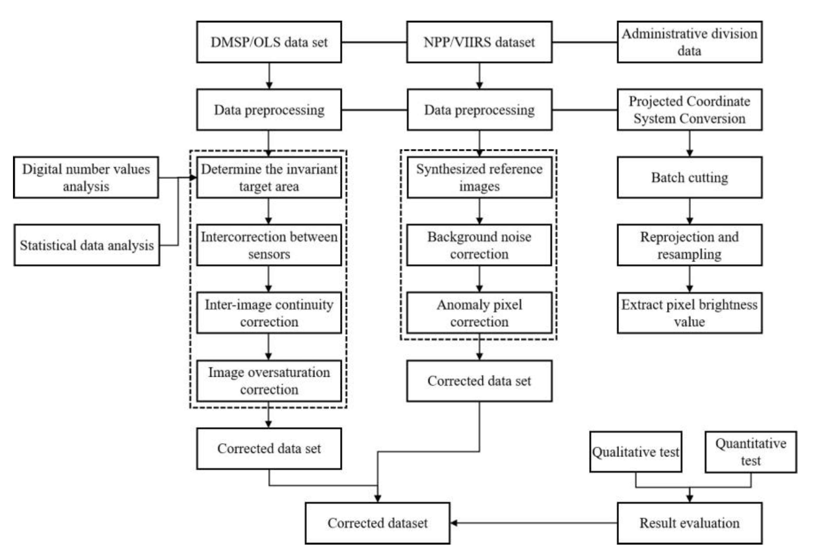
2.2.3. Night-Time Light Data
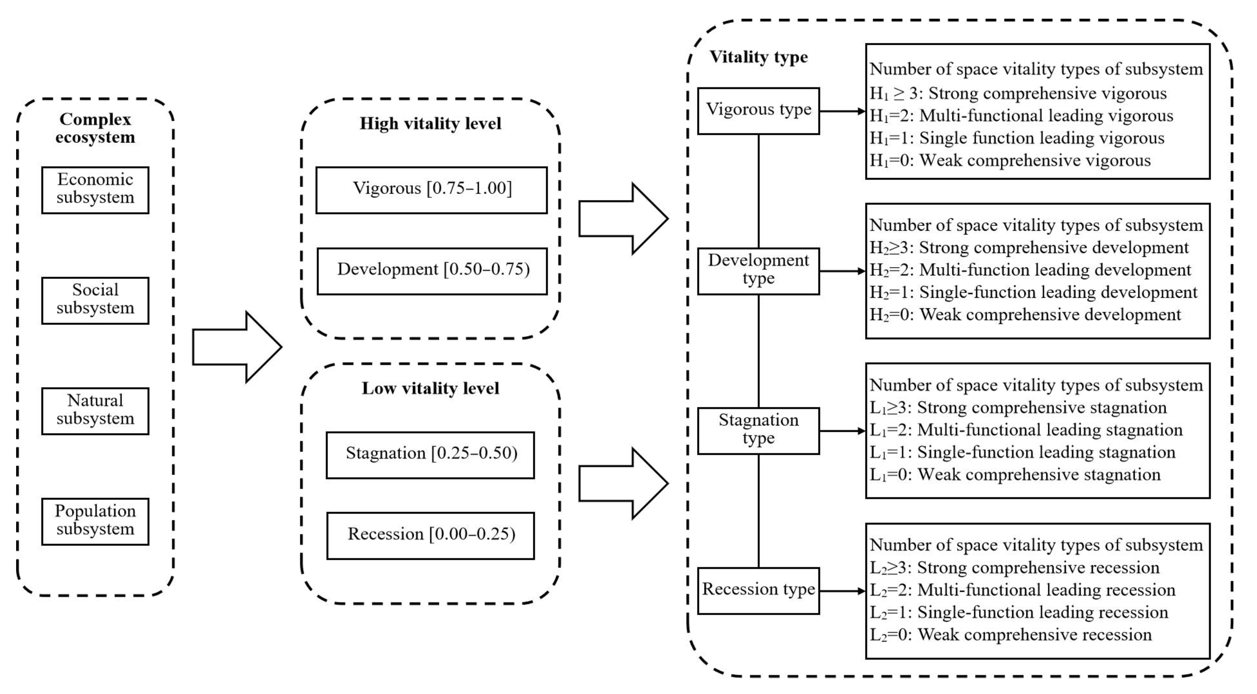
2.3. Measurement Method of Spatial Vitality Factors of Complex Ecosystem
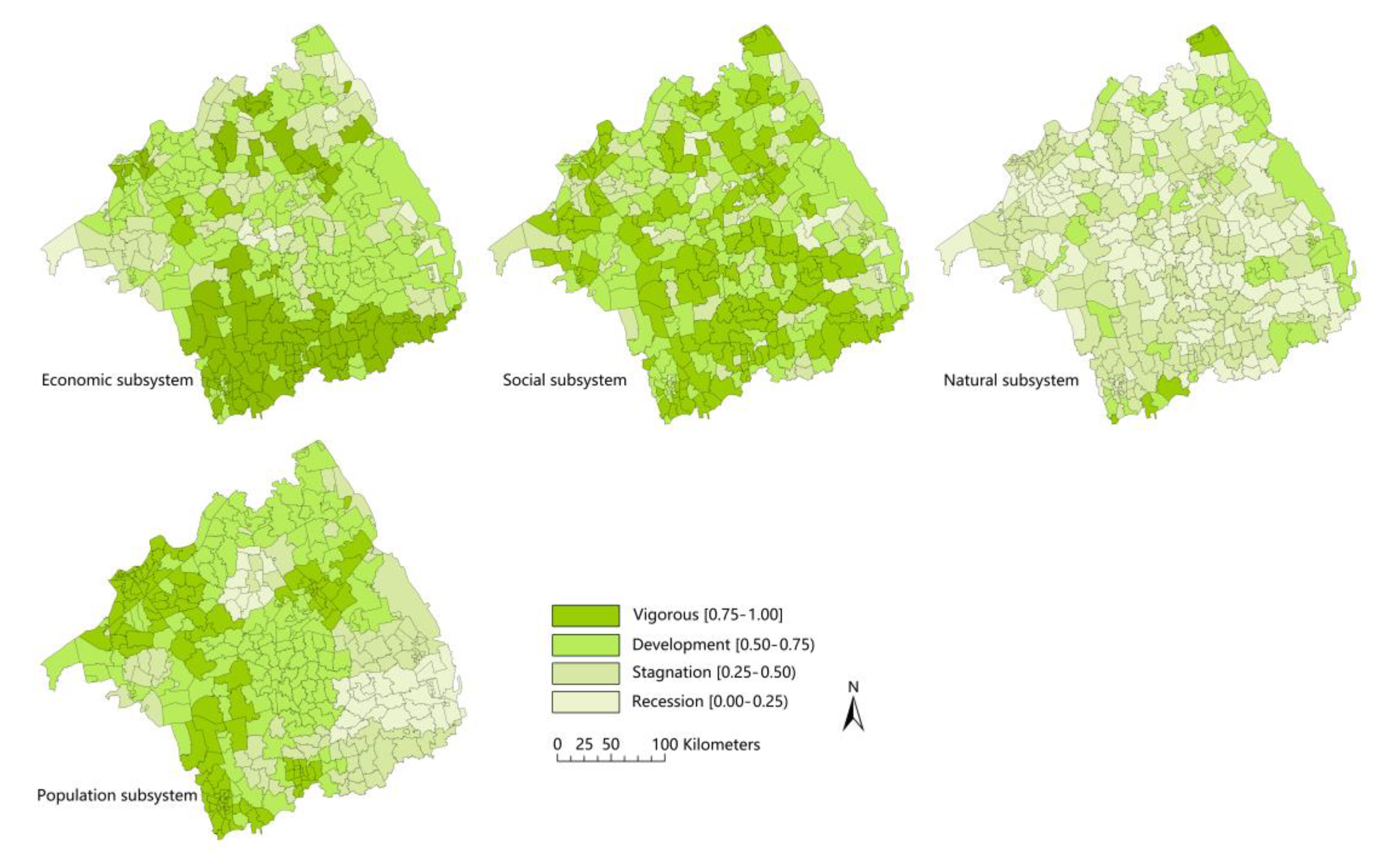
2.3.1. Economic, Social, and Natural Subsystems
2.3.2. Population Subsystems
2.4. Evaluation Method of Spatial Vitality of Complex Ecosystem
2.4.1. Assessment Framework
2.4.2. Evaluation Model
2.4.3. Division of Rank
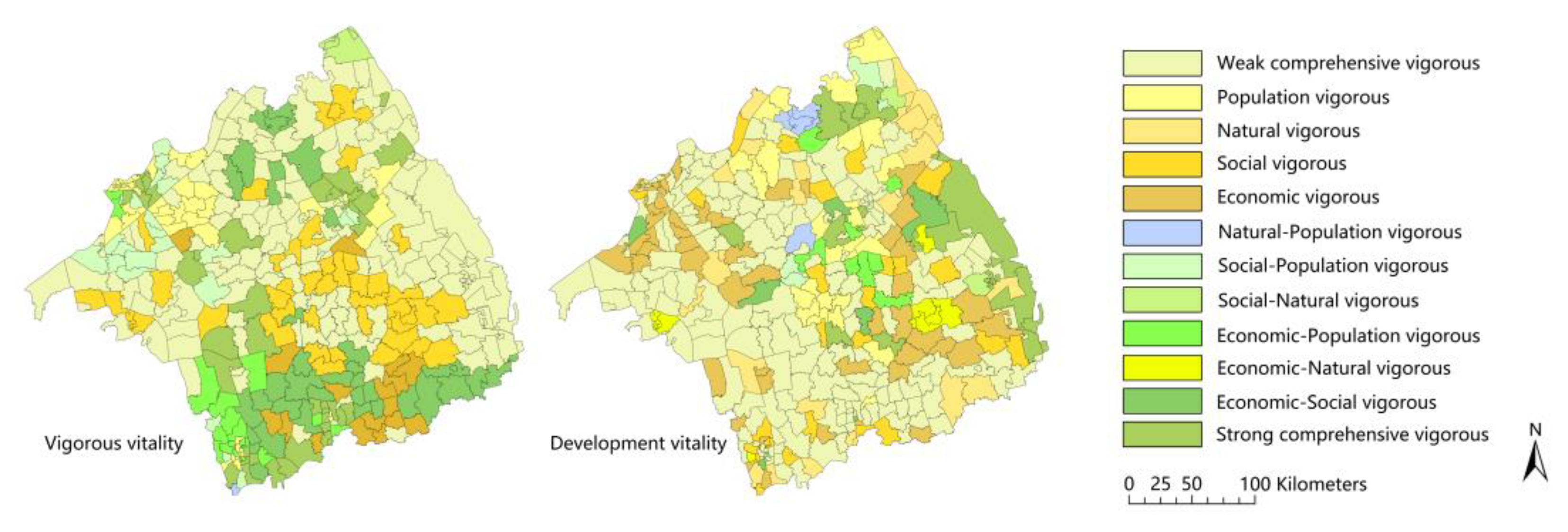
2.4.4. Type Identification
2.5. Coupling Coordination Method of Spatial Vitality of the Complex Ecosystem
2.5.1. Coupling Degree Model
2.5.2. Coupling Coordination Model
2.5.3. Spatial Correlation Analysis
2.5.4. Exploratory Space–Time Data Analysis
3. Results and Analysis
3.1. Spatial Vitality Evaluation of Complex Ecosystem
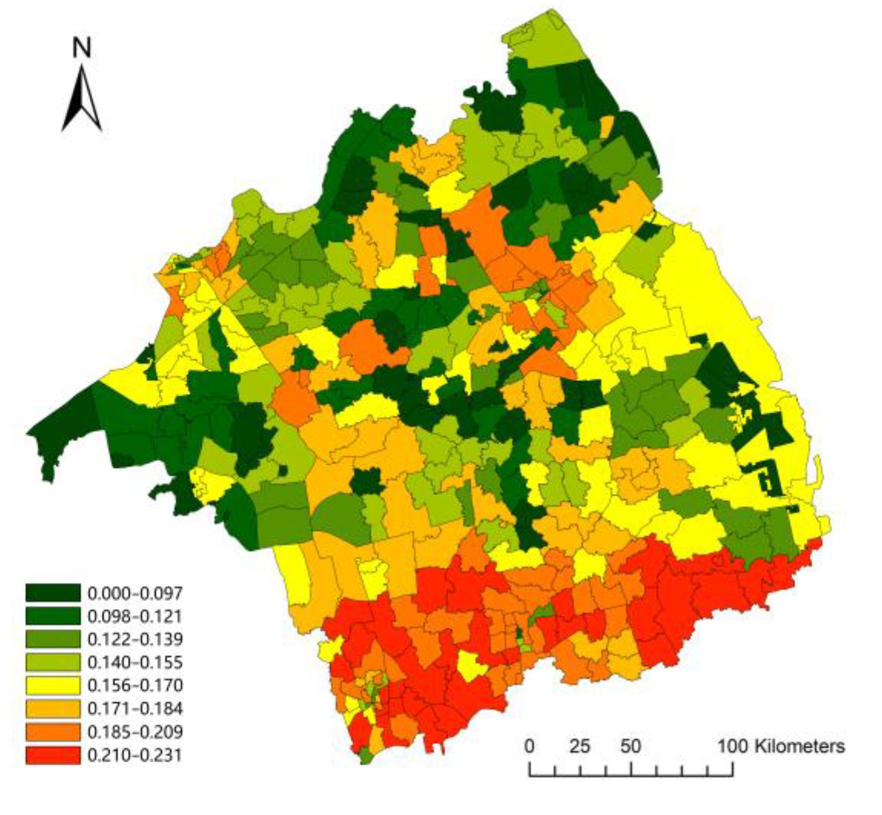
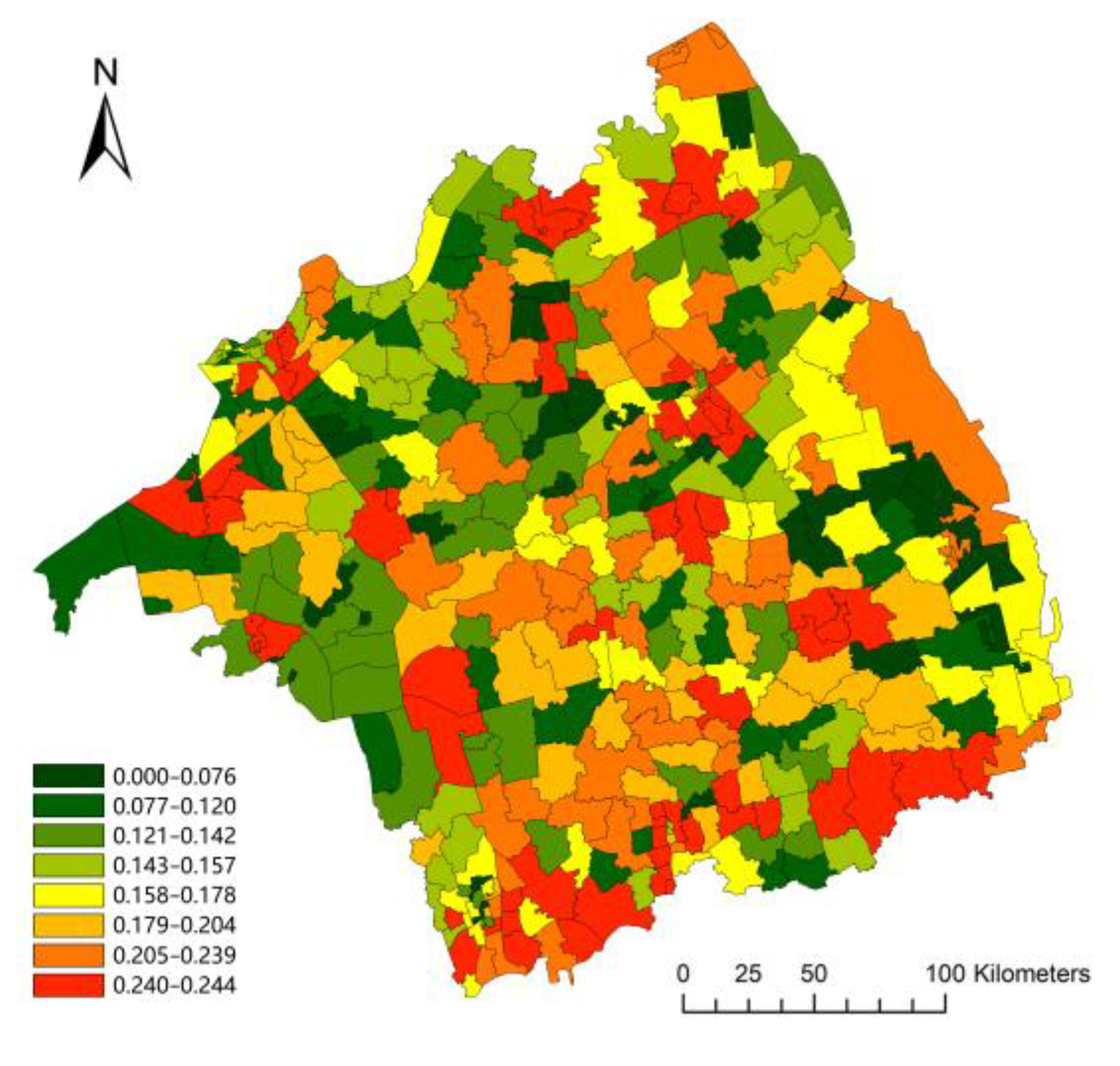
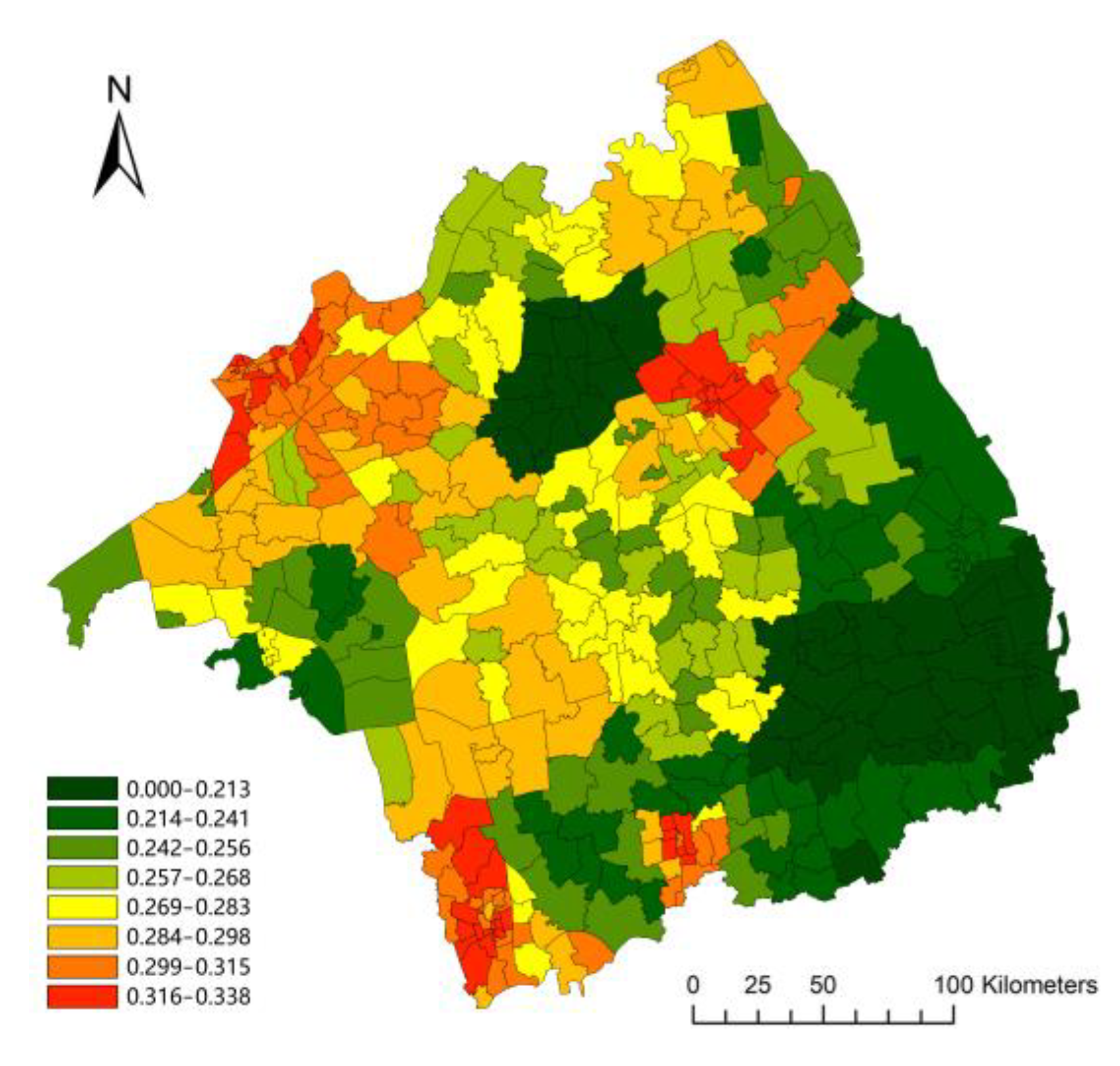
3.1.1. Gradient Characteristics of the Spatial Vitality of the Complex Ecosystem
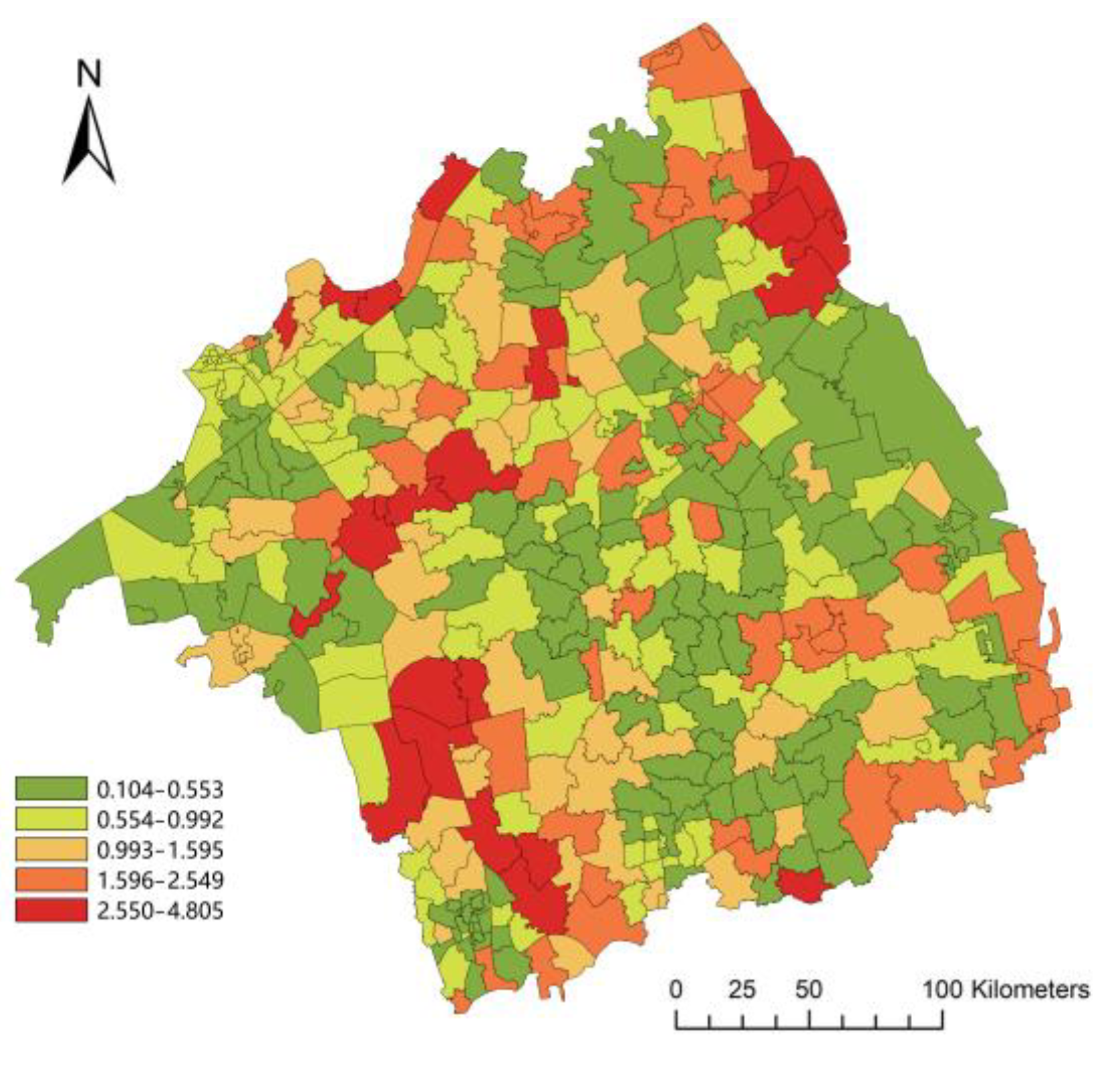
3.1.2. Distribution Characteristics of Spatial Vitality of Complex Ecosystem
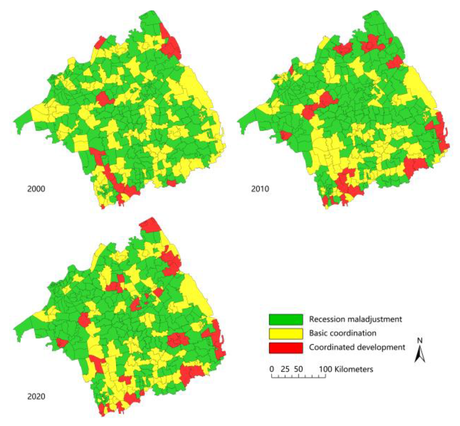
3.1.3. Type Distribution of the Spatial Vitality of the Complex Ecosystem
3.2. Coupling Regulation Mechanism of the Complex Ecosystem
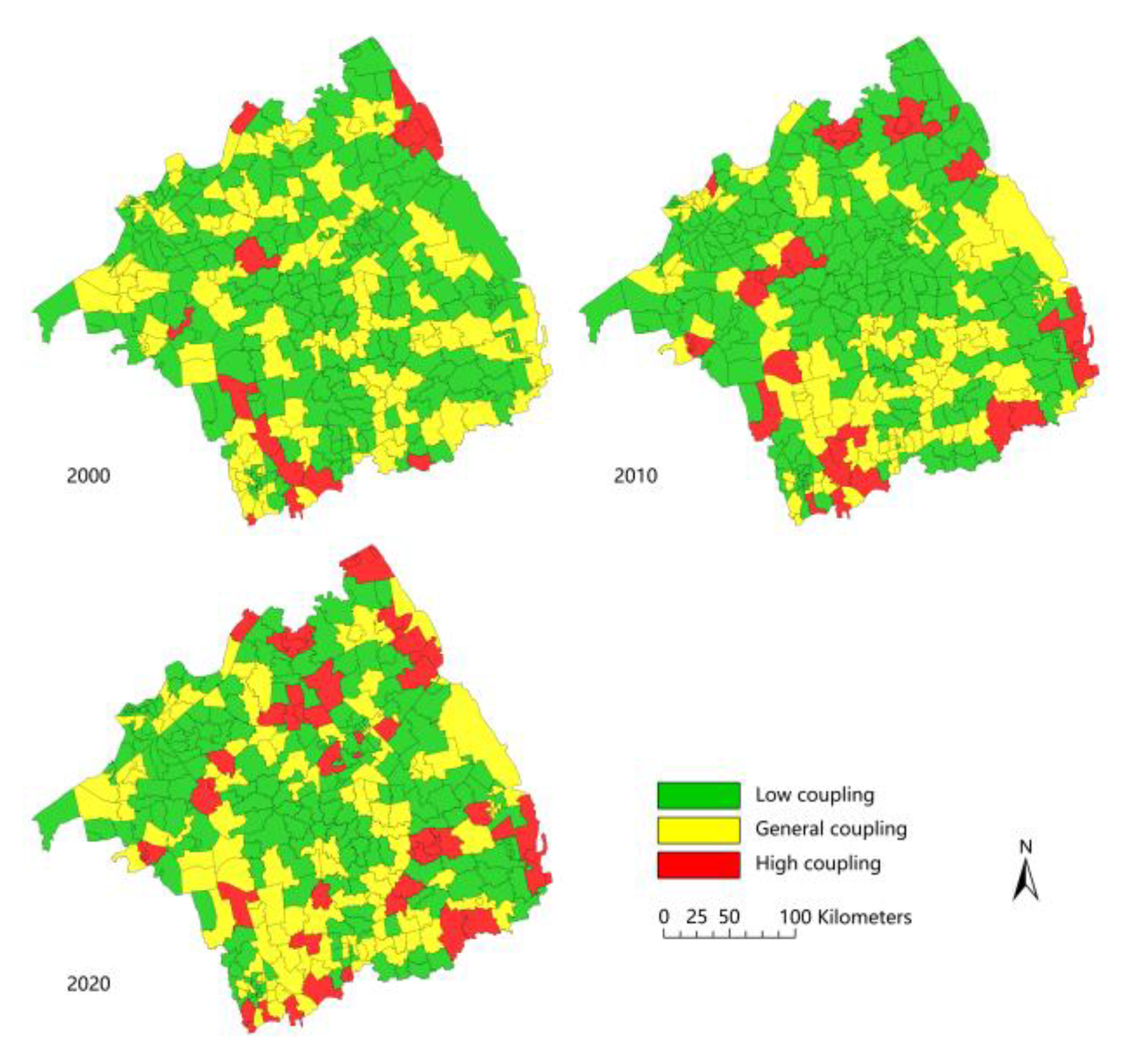
3.2.1. Spatial-Temporal Evolution Analysis of Coupling Coordination of Spatial Vitality of the Complex Ecosystem
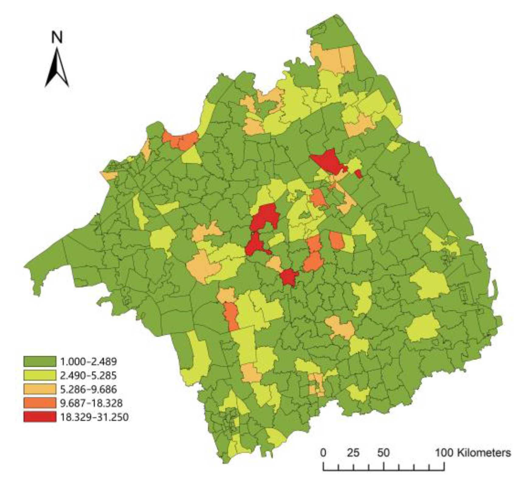
3.2.2. Spatial Association Analysis of Coupling Coordination
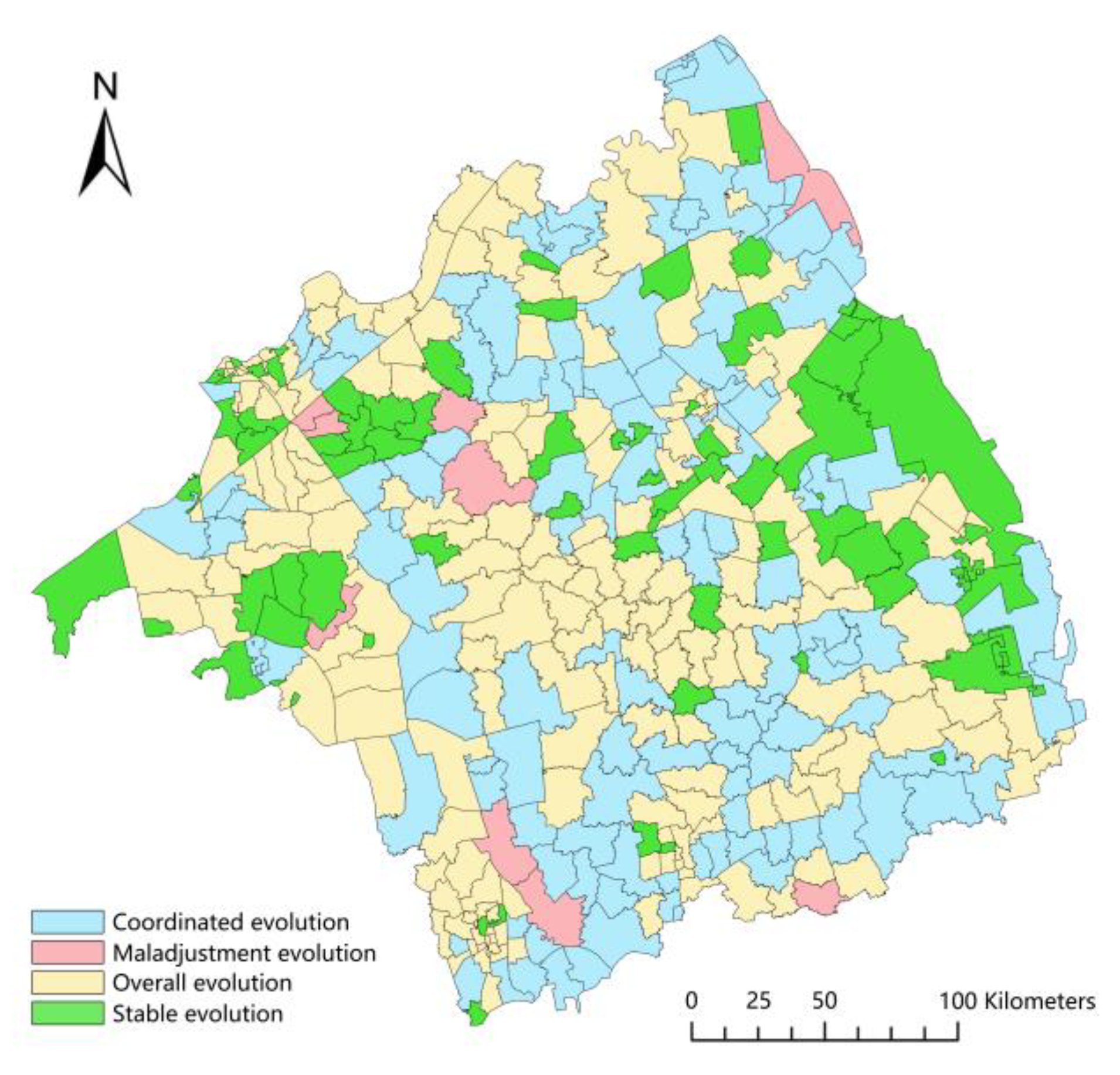
3.2.3. Evolution Type of Coupling Coordination
- (1)
- There are 107 township units of the coordinated evolution type, with small areas scattered throughout the whole Lixiahe Plain and large areas concentrated in the northeast and southern regions. From 2000 to 2020, the complex ecological subsystems promote each other, and both coupling coordination degree and spatial vitality value show an increasing trend. Among them, the average spatial vitality of this type in 2020 is 0.749, which is the best among the 4 types, the spatial vitality of the natural subsystem increases the fastest, and the economic subsystem increases the slowest.
- (2)
- There are nine township units of the maladjustment evolution type, the least in number, which are mainly distributed in the Yangzhou section of the Beijing-Hangzhou Canal in the southwest, the Huaihe River Channel and Sheyang Lake in the northwest, and the coastal area in the northeast. From 2000 to 2020, the complex ecological subsystems restrict each other, and both the coupling coordination degree and spatial vitality value showed a downward trend. Among them, the average spatial vitality of this type in 2020 is 0.627, which is second only to the coordinated evolution type, the spatial vitality of the social subsystem decreases the fastest, and the natural subsystem decreases the slowest.
- (3)
- There are 176 township units of the overall invariant type, the largest in number, with small areas scattered throughout the whole Lixiahe Plain and large areas concentrated in the northwest and central regions. The increase and decrease of the spatial vitality coordination indices of the complex ecosystem in this type of township unit are always within the range of ±0.1~1%. Among them, the average spatial vitality of this type in 2020 is 0.626, showing a similar coupling coordination type to that in 2000.
- (4)
- There are 69 township units of the stable invariant type, with small areas scattered throughout the middle of Lixiahe Plain and large areas concentrated in the eastern coastal and northwest lake areas. The increase and decrease of the spatial vitality coordination indices of the complex ecosystem in this type of township unit are always within the range of ±0~0.1%. Among them, the average spatial vitality of this type in 2020 is 0.508, which is the most stable and the worst among the four types, and the spatial vitality value also shows a slow downward trend.
4. Discussion and Conclusion
4.1. Discussion
4.2. Conclusions
4.2.1. Development Strategy of Township Units
4.2.2. Innovation and Limitation of Research
Author Contributions
Funding
Institutional Review Board Statement
Informed Consent Statement
Data Availability Statement
Conflicts of Interest
References
- Niu, W.Y. Understanding the Connotation of the Theory of Sustainable Development Commemorating the 20th Anniversary of the United Nations Rio Conference on Environment and Development. China’s Popul. Resour. Environ. 2012, 22, 9–14. [Google Scholar] [CrossRef]
- Bai, X.M.; Shi, P.J.; Liu, Y.S. Realizing China’s urban dream. Nature 2014, 509, 158–160. [Google Scholar] [CrossRef] [PubMed] [Green Version]
- Xue, B.; Li, H.Q.; Huang, B.J.; Wang, H.M.; Zhao, X.Y.; Fang, K.; Chen, C.; Chen, W.Q.; Shi, L.; Gou, X.H. Data driven research on social economic natural complex ecosystem: Scale, process and its decision-making correlation. J. Appl. Ecol. 2022, 33, 3169–3176. [Google Scholar] [CrossRef]
- Fang, C.L.; Zhou, C.H.; Gu, C.L.; Chen, L.D.; Li, S.C. The theoretical framework and technical path for the analysis of the interactive coupling effect between urbanization and ecological environment in mega urban agglomeration areas. Acta Geogr. Sin. 2016, 71, 531–550. [Google Scholar] [CrossRef]
- De Knegt, H.J.; van Langevelde, F.; Coughenour, M.B.; Skidmore, A.K.; de Boer, W.F.; Heitkönig, I.M.A.; Knox, N.M.; Slotow, R.; van der Waal, C.; Prins, H.H.T. Spatial autocorrelation and the scaling of species-environment relationships. Ecology 2010, 91, 2455–2465. [Google Scholar] [CrossRef] [Green Version]
- Batty, M. The Size, Scale, and Shape of Cities. Science 2008, 319, 769–771. [Google Scholar] [CrossRef] [PubMed] [Green Version]
- Gong, Y.X.; Ji, X.; Hong, X.C.; Cheng, S.S. Correlation Analysis of Landscape Structure and Water Quality in Suzhou National Wetland Park, China. Water 2021, 13, 2075. [Google Scholar] [CrossRef]
- Costanza, R. Ecosystem health and ecological engineering. Ecol. Eng. 2012, 45, 24–29. [Google Scholar] [CrossRef] [Green Version]
- Li, J.C.; Shi, L.M.; Xu, A.T. Discussion on the evaluation index system of high-quality development. Stat. Res. 2019, 36, 4–14. [Google Scholar] [CrossRef]
- Roberts, M.G.; Yang, G.A. International progress in research methods of sustainable development comparison between vulnerability analysis methods and sustainable livelihood methods. Prog. Geogr. Sci. 2003, 1, 11–21. [Google Scholar] [CrossRef]
- Bakshi, B. A themodynamic framework for ecologically conscious process system engineer. Comput. Chem. Eng. 2002, 26, 269–282. [Google Scholar] [CrossRef]
- Wang, Z.Y.; Ma, J.J.; Chen, X.X.; Zhao, D.; Teng, T.; Yang, Y.C. Ecological health assessment of three core development areas in Xi’an based on emergy analysis. Soil Water Conserv. Res. 2018, 25, 317–323. [Google Scholar] [CrossRef]
- Khanam, S.; Siddiqui, J.; Talib, F. A DEMATEL approach for prioritizing the TQM enablers and IT resources in the Indian ICT industry. Soc. Sci. Electron. Publ. 2016, 3, 11–29. [Google Scholar] [CrossRef] [Green Version]
- Tscharner, R.V. Place Makers: Creating Public Art That Tells You Where You Are: With an Essay on Planning and Policy; Houghton Mifflin Harcourt: Boston, MA, USA, 1987. [Google Scholar]
- Schneekloth, L.H.; Shibley, R.G. The Art and Practice of Building Communities; Wiley: Hoboken, NJ, USA, 1995. [Google Scholar]
- Trancik, R. Finding Lost Space: Theories of Urban Design; John Wiley & Sons: New York, NY, USA, 1986. [Google Scholar]
- Montgomery, J. Making a city: Urbanity, vitality and urban design. J. Urban Des. 1998, 3, 93–116. [Google Scholar] [CrossRef]
- Biddulph, M. Street design and street use: Comparing traffic calmed and home zone streets. J. Urban Des. 2012, 17, 213–232. [Google Scholar] [CrossRef]
- Ewing, R.; Handy, S. Measuring the unmeasurable: Urban design qualities related to walkability. J. Urban Des. 2009, 14, 65–84. [Google Scholar] [CrossRef]
- Wang, H.; Jiang, D. Evaluation system research on vitality of urban public space. J. Railw. Sci. Eng. 2012, 9, 56–60. [Google Scholar] [CrossRef]
- Chen, F.; Lin, J.; Zhu, X. Factor analysis on public space activity evaluation of winter cities. J. Harbin Inst. Technol. 2017, 49, 179–188. [Google Scholar] [CrossRef]
- Rundle, A.G.; Bader, M.D.M.; Richards, C.A.; Neckerman, K.M.; Teitler, J.O. Using Google Street View to Audit Neighborhood Environments. Am. J. Prev. Med. 2011, 40, 94–100. [Google Scholar] [CrossRef] [Green Version]
- Naik, N.; Philipoom, J.; Raskar, R.; Hidalgo, C. Streetscore: Predicting the Perceived Safety of One Million Streetscapes. In Proceedings of the IEEE Conference on Computer Vision and Pattern Recognition Workshops (CVPRW), Columbus, OH, USA, 23–28 June 2014; pp. 793–799. Available online: https://ieeexplore.ieee.org/document/6910072 (accessed on 1 December 2022).
- Sarkar, C.; Webster, C.; Pryor, M.; Tang, D.; Melbourne, S.; Zhang, X.H.; Liu, J.Z. Exploring Associations between Urban Green, Street Design and Walking: Results from the Greater London Boroughs. Landsc. Urban Plan. 2015, 143, 112–125. [Google Scholar] [CrossRef]
- Luo, S.Z.X.; Zhen, F. How to evaluate public space vitality based on mobile phone data: An empirical analysis of Nanjing’s parks. Geogr. Res. 2019, 38, 1594–1608. Available online: http://www.dlyj.ac.cn/CN/10.11821/dlyj020180756 (accessed on 1 December 2022).
- Dahal, R.P.; Grala, R.K.; Gordon, J.S.; Munn, D.R.; Cummings, J.R. A hedonic pricing method to estimate the value of waterfronts in the Gulf of Mexico. Urban For. Urban Green. 2019, 41, 185–194. [Google Scholar] [CrossRef]
- Liu, S.Y.; Zhao, P.J.; Liang, J.S. Study on Urban Vitality Based on LBS Data: A Case of Beijing within 6th Ring Road. Areal Res. Dev. 2018, 37, 64–69,87. Available online: http://hdl.handle.net/20.500.11897/572803 (accessed on 1 December 2022).
- Wang, W.Q.; Ma, X.J. Vitality Assessment of Waterfront Public Space Based on Multi-Source Data: A Case Study of the Huangpu River Waterfront. Urban Plan. Forum 2020, 1, 48–56. [Google Scholar] [CrossRef]
- Yang, X.; Fang, Z.; Xu, Y.; Shaw, S.-L.; Zhao, Z.; Yin, L.; Zhang, Z.; Lin, Y. Understanding Spatiotemporal Patterns of Human Convergence and Divergence Using Mobile Phone Location Data. ISPRS Int. J. Geo-Inf. 2016, 5, 177. [Google Scholar] [CrossRef] [Green Version]
- Zeng, C.; Song, Y.; He, Q.Q.; Shen, F.X. Spatially Explicit Assessment on Urban Vitality: Case Studies in Chicago and Wuhan. Sustain. Cities Soc. 2018, 40, 296–306. [Google Scholar] [CrossRef]
- Liu, S.; Lai, S. Measurement of Urban Public Space Vitality Based on Big Data. Landsc. Archit. 2019, 26, 24–28. [Google Scholar] [CrossRef]
- Lei, Y.; Lu, C.; Su, Y.; Huang, Y. Research on the coupling relationship between urban vitality and urban sprawl based on the multi-source night-time light data—A case study of the west Taiwan strait urban agglomeration. Hum. Geogr. 2022, 37, 119–131. [Google Scholar] [CrossRef]
- Wang, M.; Chen, M.X.; Song, H.Y. Influence of Coupled Coordination of Habitat Quality and Recreation Services on the Vitality of Waterfront Space. J. Chin. Urban For. 2022, 20, 7–13. [Google Scholar] [CrossRef]
- Zhang, Y.; Ji, X.; Sun, L.; Gong, Y.X. Spatial Evaluation of Villages and Towns Based on Multi-Source Data and Digital Technology: A Case Study of Suining County of Northern Jiangsu. Sustainability 2022, 14, 7603. [Google Scholar] [CrossRef]
- Ye, J.; Yang, X.H.; Jiang, D. The grid scale effect analysis on town leveled population statistical data spatialization. J. Geo-Inf. Sci. 2010, 12, 40–47. Available online: http://www.dqxxkx.cn/CN/Y2010/V12/I1/40 (accessed on 1 December 2022).
- Shi, K.F.; Yu, B.L.; Huang, Y.X.; Hu, Y.J.; Yin, B.; Chen, Z.Q.; Chen, L.J.; Wu, J.P. Evaluating the ability of NPP-VIIRS nighttime light data to estimate the gross domestic product and the electric power consumption of China at multiple scales: A comparison with DMSP-OLS data. Remote Sens. 2014, 6, 1705–1724. [Google Scholar] [CrossRef] [Green Version]
- Turner, B.L.; Skole, D.L.; Sanderson, S.; Fischer, G.; Fresco, L.; Leemans, R. Land Use and Land Cover Change. Science/Research Plan; IGBP Report No. 35 & HDP report No. 7; IGBP: Stockholm, Sweden, 1995. [Google Scholar] [CrossRef]
- Wang, D.; Ji, X.; Li, C.; Gong, Y.X. Spatiotemporal Variations of Landscape Ecological Risks in a Resource-Based City under Transformation. Sustainability 2021, 13, 5297. [Google Scholar] [CrossRef]
- Diao, M.; Zhu, Y.; Ferreira, J.; Ratti, C. Inferring Individual Daily Activities from Mobile Phone Traces: A Boston Example. Environ. Plan. B Plan. Des. 2016, 43, 920–940. [Google Scholar] [CrossRef] [Green Version]
- Xu, Y.; Shaw, S.L.; Zhao, Z.L.; Yin, L.; Lu, F.; Chen, J.; Fang, Z.X.; Li, Q.Q. Another Tale of Two Cities: Understanding Human Activity Space Using Actively Tracked Cellphone Location Data. Ann. Am. Assoc. Geogr. 2016, 106, 489–502. Available online: https://www.tandfonline.com/doi/full/10.1080/00045608.2015.1120147 (accessed on 1 December 2022).
- Wang, W.Q.; Ma, X.J. Research on the vitality evaluation of waterfront public space based on multi-source data taking the Huangpu River waterfront as an example. J. Urban Plan. 2020, 1, 48–56. [Google Scholar] [CrossRef]
- Wu, K.M.; Zhang, H.O.; Wang, Y.; Wu, Q.T.; Ye, Y.Y. Identify of the multiple types of commercial center in Guangzhou and its spatial pattern. Prog. Geogr. 2016, 35, 963–974. [Google Scholar] [CrossRef] [Green Version]
- Wang, J.F.; Ge, Y.; Li, L.F.; Meng, B.; Wu, J.L.; Bo, Y.C.; Du, S.H.; Liao, Y.L.; Hu, M.G.; Xu, C.D. Spatiotemporal data analysis in geography. Acta Geogr. Sin. 2014, 69, 1326–1345. [Google Scholar] [CrossRef]
- Jiang, S.; Alves, A.; Rodrigues, F.; Ferreira, J.; Pereira, F.C. Mining point of interest data from social networks for urban land use classification and disaggregation. Comput. Environ. Urban Syst. 2015, 53, 36–46. [Google Scholar] [CrossRef] [Green Version]
- Chen, Y.M.; Liu, X.P.; Li, X. Analyzing parcel-level relationships between urban land expansion and activity changes by integrating landsat and nighttime light data. Remote Sens. 2017, 9, 164. [Google Scholar] [CrossRef] [Green Version]
- Dang, L.J.; Xu, Y.; Gao, Y. Assessment method of functional land use classification and spatial system: A case study of Yangou Watershed. Res. Soil Water Conserv. 2014, 21, 193–197. [Google Scholar] [CrossRef]
- Long, H.L.; Liu, Y.Q.; Li, T.T.; Wang, J.; Liu, A.X. A primary study on ecological land use classification. Ecol. Environ. Sci. 2015, 24, 1–7. [Google Scholar] [CrossRef]
- Elvidge, C.D.; Baugh, K.E.; Zhizhin, M.; Hsu, F.C. Why VIIRS data are superior to DMSP for mapping nighttime lights. Proc. Asia Pac. Adv. Netw. 2013, 35, 62–69. [Google Scholar] [CrossRef]
- Li, X.; Xu, H.M.; Chen, X.L.; Li, C. Potential of NPP-VIIRS nighttime light imagery for modeling the regional economy of China. Remote Sens. 2013, 5, 3057–3081. [Google Scholar] [CrossRef] [Green Version]
- Elvidge, C.D.; Ziskin, D.; Baugh, K.E.; Tuttle, B.T.; Ghosh, T.; Pack, D.W.; Erwin, E.H.; Zhizhin, M. A fifteen year record of global natural gas flaring derived from satellite data. Energies 2009, 2, 595–622. [Google Scholar] [CrossRef]
- Wu, J.S.; He, S.B.; Peng, J.; Li, W.F.; Zhong, X.H. Intercalibration of DMSP/OLS night-time light data by the invariant region method. Int. J. Remote Sens. 2013, 34, 7356–7368. [Google Scholar] [CrossRef]
- Zhuo, L.; Zheng, J.; Zhang, X.F.; Li, J.; Liu, L. An improved method of night-time light saturation reduction based on EVI. Int. J. Remote Sens. 2015, 36, 4114–4130. [Google Scholar] [CrossRef]
- Yu, B.L.; Tang, M.; Wu, Q.S.; Yang, C.S.; Deng, S.Q.; Shi, K.F.; Peng, C.; Wu, J.P.; Chen, Z.Q. Urban Built-Up Area Extraction from Log-Transformed NPP-VIIRS Nighttime Light Composite Data. IEEE Geosci. Remote Sens. Lett. 2018, 15, 1279–1283. [Google Scholar] [CrossRef]
- Li, X.; Li, D.R.; Xu, H.M.; Wu, C.Q. Intercalibration between DMSP/OLS and VIIRS night-time light images to evaluate city light dynamics of Syria’s major human settlement during Syrian Civil War. Int. J. Remote Sens. 2017, 38, 5934–5951. [Google Scholar] [CrossRef]
- Li, M.; Shen, Z.; Hao, X. Revealing the relationship between spatio-temporal distribution of population and urban function with social media data. GeoJournal 2016, 81, 919–935. Available online: https://www.jstor.org/stable/44132611 (accessed on 1 December 2022).
- Zeng, C.Q.; Zhou, Y.; Wang, S.X.; Yan, F.L.; Zhao, Q. Population spatialization in China based on night-time imagery and land use data. Int. J. Remote Sens. 2011, 32, 9599–9620. [Google Scholar] [CrossRef]
- Wei, Y.; Liu, H.X.; Song, W.; Yu, B.L.; Xiu, C.L. Normalization of time series DMSP-OLS nighttime light images for urban growth analysis with Pseudo Invariant Features. Landsc. Urban Plan. 2014, 128, 1–13. [Google Scholar] [CrossRef]
- Dong, P.L.; Ramesh, S.; Nepali, A. Evaluation of small-area population estimation using LiDAR, Landsat TM and parcel data. Int. J. Remote Sens. 2010, 31, 5571–5586. [Google Scholar] [CrossRef]
- Alshehri, S.A.; Rezgui, Y.; Li, H. Disaster community resilience assessment method: A consensus-based Delphi and AHP approach. Nat. Hazards 2015, 78, 395–416. [Google Scholar] [CrossRef]
- Wang, F.X.; Mao, A.H.; Li, H.L.; Jia, M.L. Quality measurement and spatial difference analysis of urbanization in Shandong Province based on entropy method. Geogr. Sci. 2013, 33, 1323–1329. [Google Scholar] [CrossRef]
- Niu, X.; Du, Z.; Li, T. Evaluation of regional urbanization level based on a new urbanization perspective—Taking 10 cities under the jurisdiction of Shaanxi Province as an example. Arid Zone Geogr. 2013, 36, 354–363. [Google Scholar] [CrossRef]
- Kline, J.D.; Moses, A.; Alig, R.J. Integrating Urbanization into Landscape-level Ecological Assessments. Ecosystems. 2001, 4, 3–18. [Google Scholar] [CrossRef]
- Kim, D.S.; Mizuno, K.; Kobayashi, S. Analysis of urbanization characteristics causing farmland loss in a rapid growth area using GIS and RS. Paddy Water Environ. 2003, 1, 189–199. [Google Scholar] [CrossRef]
- Zhu, Q.; Fu, X. The Review of Visual Analysis Methods of Multi-modal Spatio-temporal Big Data. Acta Geogr. Sin. 2017, 46, 1672–1677. [Google Scholar] [CrossRef]
- Jin, Q.; Wang, Y. Le Corbusier. Radiant City; China Architecture & Building Press: Beijing, China, 2011. [Google Scholar]
- Hoyt, H. One Hundred Years of Land Values in Chicago; Jia, Z., Ed.; Economic Science Press: Beijing, China, 2011. [Google Scholar]
- Feng, C.C.; Yang, Z.W. Review of Urban Land Use in Europe and America. Urban Plan. Int. 1998, 19, 2–9. Available online: https://kns.cnki.net/kcms2/article/abstract?v=20d6x5-H6Wkv1G89iOUuveKoJGJsPSzMx78hQKW6q0ndrKF7MbPFkbvpXFk4DObatI3_z45bFiPbNs2MW9oKarlICCa77imOB4GeM0ykzc_FjJ3dxtV9Qw==&uniplatform=NZKPT&language=CHS (accessed on 1 December 2022).
- Gu, K. Theory and Method of Urban Form—Explore a comprehensive and rational research framework. City Plan. Rev. 2001, 25, 36–42. Available online: https://kns.cnki.net/kcms2/article/abstract?v=20d6x5-H6WmrJry1JpLlRDPuInM5QnxMHrK5KBJivyotpLo9clWoQiYjtwSnXqq7AP4ZaeSdBYn9gI8VHw7pWFkJazPTubD22zZs3kbHIoe8W5gjeMtJZQ==&uniplatform=NZKPT&language=CHS (accessed on 1 December 2022).
- Eliel, S. City: Its Growth, Its Decay, Its Future; Gu, Q., Ed.; China Architecture & Building Press: Beijing, China, 1986. [Google Scholar]
- Ebenezer, H. Garden Cities of Tomorrow; The Commercial Press: Beijing, China, 2010. [Google Scholar]
- Shi, Y.S. A Summary of Village and Town Systems Research at Home and Abroad. Urban Plan. Int. 2007, 4, 84–88. Available online: https://kns.cnki.net/kcms/detail/detail.aspx?dbcode=CJFD&dbname=CJFD2007&filename=GWCG200704017&uniplatform=NZKPT&v=2ycJ-7IoWDI3MvwcGUer-IVKjYYucdcXd869SloDcKW45zmBgEwk-RVneiVK7pyP (accessed on 1 December 2022).
- He, S.W. The original sin of urban sprawl—On the History of Decentralism. Planners 2008, 15, 97–100. Available online: https://kns.cnki.net/kcms2/article/abstract?v=20d6x5-H6WnjFd-nWuZ_Ov9ROH2sSoWXSD5dvWI04RSlZUPPYA6E9LMnj8uKc1G8hpolMmN4Sf84MusfltkpOfTjJmjgRISX3fQ4TM8SDVQcHiLAuHujJw==&uniplatform=NZKPT (accessed on 1 December 2022).
- Liang, J. A reexamination of the market principle in central place theory. Acta Geogr. Sin. 2022, 77, 1892–1906. Available online: https://kns.cnki.net/kcms2/article/abstract?v=20d6x5-H6Wk2gWsXojirPAY7EoiXQlg-54YkQEi3V5j3Tm53NqyFwOTfeva3ftO0UH4S84IRNvCbpP_k6zUAcZT0NQI0vtmr1De6uYzjhhNk3hBH1RNewRqCVIQlSE3y&uniplatform=NZKPT&language=CHS (accessed on 1 December 2022).
- Liang, J.S. Central place system substitutability and point-axle system. Acta Geogr. Sin. 1998, S1, 204–211. Available online: https://kns.cnki.net/kcms/detail/detail.aspx?dbcode=CJFD&dbname=CJFD9899&filename=DLXB1998S1025&uniplatform=NZKPT&v=97EOHO6OO6EFCBWx_4qcXYQwHlqs1IIu5FA2Gqd6nTtIT0L2WAw4m_Eq6qEc6yeo (accessed on 1 December 2022).
- Li, D.Q.; Zheng, G.; Luo, X. Revisiting neighborhood unit and residential community: A knowledge transfer perspective. City Plan. Rev. 2021, 45, 36–42. Available online: https://kns.cnki.net/kcms/detail/detail.aspx?dbcode=CJFD&dbname=CJFDLAST2021&filename=CSGH202111008&uniplatform=NZKPT&v=e0VWQrSXHmS-j_2AFmW-d7reep9NJnUVTaBQ4Xp2InbpGUmvcLDpcl6S6xTL6AGW (accessed on 1 December 2022).
- Qiu, B.X. Six transitions in the evolution of western urban planning theories since the 19th century. Planners 2003, 10, 5–10. Available online: https://kns.cnki.net/kcms2/article/abstract?v=20d6x5-H6Wl3dDB_cA_YvlSUPnMbCZM-BXoPtMvzcg888XyIlpdlnxzkHGGKqRPKnc_77hfmHAifmbOG0TcF9ZRvS0F_TmwDFBbV0UTqH9_cRMHPTciImQ==&uniplatform=NZKPT&language=CHS (accessed on 1 December 2022).
- Tiesdale, S.; Heath, T. Revitaliazing Historic Urban Quarters; Zhang, M., Dong, W., Eds.; China Architecture & Building Press: Beijing, China, 2006. [Google Scholar]
- Huang, G.; Chen, Y. Study on the concept of eco city and its planning and design method. City Plan. Rev. 1997, 21, 17–20. Available online: https://kns.cnki.net/kcms2/article/abstract?v=20d6x5-H6WnBPoWI2Rzvtw5D1Tlx-oWXDWfHWDvhmgceeoKNAUXdY9Fv6kagdG7XOP5B2_zfN-qTOMvLhhDkCRpoivZE1IpOMlG4kgEQ-K1VgB4rNDz60A==&uniplatform=NZKPT (accessed on 1 December 2022).
- Wu, L.Y. “Landscape City” and Urban Development in China in the 21st Century. Archit. J. 1993, 33, 4–8. Available online: https://kns.cnki.net/kcms2/article/abstract?v=20d6x5-H6WmX341YZY5qgNxi3B8aQ5gWsY-aIYa0wwJUP-6ZmlZdNVn9ngcnDkkflxE0g8FDrfu1j9w8hvds1AVJdcQ-akEo8zVpJfQ6nKhZCxhlPOlYvw==&uniplatform=NZKPT&language=CHS (accessed on 1 December 2022).
- Liu, Y.; Li, R.; Song, X. Summary and Comment of the Correlation Study of Urbanization and Urban Eco-Environment. China Popul. Resour. Environ. 2005, 15, 55–60. Available online: https://kns.cnki.net/kcms2/article/abstract?v=20d6x5-H6WmgdEnnzjDezUQl6zMnE1823NmBoTVs6YBwujVYVcxTKjOFHWXDx7ucBOn39s_mpWuL8PKLC9Kx33VIO3XT_f5xnKe-W6Dj_KUIcloaXH4N7Q==&uniplatform=NZKPT&language=CHS (accessed on 1 December 2022).
- Li, T. New Progress in Study on Resilient Cities. Urban Plan. Int. 2017, 32, 15–25. Available online: https://kns.cnki.net/kcms2/article/abstract?v=20d6x5-H6WlaXWn7MmdJxy9mFODYOAQpR7CpWRCo6aRlctyo7TpkKvsgORNpH8Ms9WteHYUs5Uk0hclJsftm9M-0iErAdT97R6tuR1C6QBUz71mJ-Hv7YCB7RAvRvoQZ&uniplatform=NZKPT&language=CHS (accessed on 1 December 2022). [CrossRef]
- Liu, Z.L.; Dai, Y.X.; Dong, C.G.; Qi, Y. Low-Carbon City: Concepts, International Practice and Implications for China. Urban Dev. Study 2009, 16, 1–7,12. Available online: https://kns.cnki.net/kcms2/article/abstract?v=20d6x5-H6WlVHWXtGQOS0J9_9v6U81FDTk7ilW8Pa1tip0rjam08fajcdv2Z-_2_UFVmvPbWTuHmXUvzGzRB04l6OQ9YNTh_zEr4fTeDeCMOotjFFc4T8Q==&uniplatform=NZKPT&language=CHS (accessed on 1 December 2022).
- Yu, K.J.; Li, D.H.; Yuan, H.; Fu, W.; Qiao, Q.; Wang, S.S. “Sponge City”: Theory and Practice. City Plan. Rev. 2015, 39, 26–36. Available online: https://kns.cnki.net/kcms2/article/abstract?v=20d6x5-H6Wm9XSxhgF84_FG7dFSbUNDncwAYeznCculkka0TruCsJzrqNh-MStfWW9oaTPrUcqxdH3qO0x_-frET-_AMVpASSjmYMbLZJqicjsSZJ7Fghbc6V9I7Abn8&uniplatform=NZKPT&language=CHS (accessed on 1 December 2022).
- Jacobs, J. The Death and Life of Great American Cities; Vintage: New York, NY, USA, 1961. [Google Scholar]
- Lynch, K. Good City Form; The MIT Press: Cambridge, MA, USA, 1984. [Google Scholar]
- Gale, J. Humanized City; Xu, Z., Ed.; China Architecture & Building Press: Beijing, China, 2010. [Google Scholar]
- Bentley, I. Resonance Design of Building Environment; Ji, X., Gao, Y., Eds.; Dalian University of Technology Press: Dalian, China, 2002. [Google Scholar]
- Zou, Q.; Li, G. Public Space Construction of Urban Resettlement Community Based on Analysis of Vitality Characteristics: Taking the 6 Resettlement Communities of Suzhou as Examples. Sci. Geogr. Sin. 2018, 38, 747–754. [Google Scholar] [CrossRef]
- Kendall, A.; Badrinarayanan, V.; Cipolla, R. Bayesian SegNet: Model Uncertainty in Deep Convolutional Encoder-Decoder Architectures for Scene Understanding. IEICE Trans. Fundam. Electron. Commun. Comput. Sci. 2015. [Google Scholar] [CrossRef]
- Long, Y.; Zhou, Y. Quantitative Evaluation on Street Vibrancy and Its Impact Factors: A case Study of Chengdu. New Archit. 2016, 34, 52–57. Available online: https://kns.cnki.net/kcms2/article/abstract?v=20d6x5-H6Wn-xyz96dQBNf3h5OlDZ-GOK8lfBABeRYd48b1_1flyJ7MOfHFeLAA94vv-uY81Nt1S7qp6hdEWZRySID1JKrawF6MTKbV8Mp0lK6OxD0Sihj1y4TUyL3vs&uniplatform=NZKPT (accessed on 1 December 2022).
- Long, Y.; Liu, L. Four Transformations of Chinese Quantitative Urban Research in the New Data Environment. Urban Plan. Int. 2017, 32, 64–73. Available online: https://kns.cnki.net/kcms2/article/abstract?v=20d6x5-H6WmqFWumc_ui2l6xRR89AiZkFBAeroBak7derVI0ywA0crJey7T7XoHZdVZV0C7WnAqvzWUNKQVuXoF7xpEOquoF0gEjZx8BQBayscVPRVAz0k_MXoc2PS-Q&uniplatform=NZKPT&language=CHS (accessed on 1 December 2022). [CrossRef] [Green Version]
- Wang, Y.Z. Research on Urban Spatial Vitality Characteristic Evaluation and Internal Mechanism of Shanghai Central City Based on Mobile Phone Signaling Data; Southeast University: Dhaka, Bangladesh, 2017. [Google Scholar]
- Qiu, Y. Research on Urban Street Spatial Vitality Evaluation Based on Multi-Source Data: A Case Study of Suzhou Ancient Downtown; Suzhou University of Science and Technology: Suzhou, China, 2019; Available online: https://kns.cnki.net/kcms/detail/detail.aspx?dbcode=CMFD&dbname=CMFD202001&filename=1019191965.nh&uniplatform=NZKPT&v=8rdYUdN8h3rs77EvMzl4Wbk-vxotFDQwij34hbNzcuB75o8o8zJCxQotob48WYLM (accessed on 1 December 2022).
- Wakamiya, S.; Lee, R.; Sumiya, K. Urban Area Characterization Based on Semantics of Crowd Activities in Twitter. Pers. Ubiquitous Comput. 2011, 4, 108–123. Available online: https://dl.acm.org/doi/10.1007/s00779-012-0510-9 (accessed on 1 December 2022).
- Mark, B.; Nick, M. Microscopic Simulations of Complex Metropolitan Dynamics; Complex City Workshop: Amsterdam, The Netherlands, 2011. [Google Scholar]
- Steiger, E.; Westerholt, R.; Resch, B.; Zipf, A. Twitter as an indicator for whereabouts of people? Correlating Twitter with UK census data. Comput. Environ. Urban Syst. 2015, 54, 255–265. [Google Scholar] [CrossRef]
- Malleson, N.; Birkin, M. Analysis of crime patterns through the integration of an agent-based model and a population microsimulation. Comput. Environ. Urban Syst. 2012, 36, 551–561. [Google Scholar] [CrossRef]


| Residual | Correction Function | Corrected R2 | Corrected RMSE |
|---|---|---|---|
| (−∞,−81,000] | y = 1.6886x + 77,699 | 0.9899 | 5251 |
| [−80,999,−51,000] | y = 1.0341x + 63,274 | 0.9962 | 4192 |
| [−50,999,−21,000] | y = 1.0380x + 32,621 | 0.9789 | 8515 |
| [−20,999,−6000] | y = 1.0091x + 11,757 | 0.9607 | 4352 |
| [−5999,5999] | y = 0.9735x + 764 | 0.9799 | 3173 |
| [6000,20,999] | y = 0.9831x − 11,748 | 0.9740 | 3911 |
| [21,000,50,999] | y = 0.9675x − 28,749 | 0.9740 | 7956 |
| [51,000,80,999] | y = 0.9772x − 58,297 | 0.9885 | 7565 |
| [81,000,+∞) | y = 0.9064x − 87,002 | 0.9999 | 547 |
| Subsystem | NO. | Indices | Unit | Reference | AHP | EWM | Comprehensive | Features |
|---|---|---|---|---|---|---|---|---|
| Economic | X1 | Hotel | Pixel | 4.54 c | 0.145 | 0.068 | 0.016 | + |
| X2 | Inn | Pixel | 3.47 c | 0.174 | 0.031 | 0.009 | + | |
| X3 | Bank, ATM | Pixel | 3.36 c | 0.136 | 0.104 | 0.023 | + | |
| X4 | Insurance, Securities, Finance | Pixel | 3.15 c | 0.148 | 0.045 | 0.012 | + | |
| X5 | Company | Pixel | 24.69 c | 0.104 | 0.160 | 0.028 | + | |
| X6 | Factory | Pixel | 9.14 c | 0.149 | 0.241 | 0.060 | + | |
| X7 | GDP per km2 | Million yuan/km2 | 0.96 a | 0.143 | 0.352 | 0.084 | + | |
| Social | X8 | Entertainment and leisure place | Pixel | 5.63 c | 0.102 | 0.044 | 0.008 | + |
| X9 | Stadium | Pixel | 2.29 c | 0.254 | 0.090 | 0.038 | + | |
| X10 | General and specialized hospitals | Pixel | 4.35 c | 0.105 | 0.090 | 0.016 | + | |
| X11 | Clinics and health center | Pixel | 6.07 c | 0.098 | 0.031 | 0.005 | + | |
| X12 | Airport and railway station | Pixel | 0.90 c | 0.214 | 0.189 | 0.067 | + | |
| X13 | Subway and bus station | Pixel | 17.41 c | 0.096 | 0.189 | 0.030 | + | |
| X14 | Accessibility of public services | / | 1.62 c | 0.132 | 0.366 | 0.080 | + | |
| Natural | X15 | Cultivated land | Pixel | 52.21 c | 0.026 | 0.074 | 0.003 | + |
| X16 | Grassland | Pixel | 0.48 c | 0.279 | 0.125 | 0.058 | + | |
| X17 | Water area | Pixel | 8.65 c | 0.086 | 0.074 | 0.011 | + | |
| X18 | Urban construction land | Pixel | 3.91 c | 0.079 | 0.340 | 0.044 | + | |
| X19 | Rural residential area | Pixel | 6.40 c | 0.032 | 0.191 | 0.010 | + | |
| X20 | Other construction land | Pixel | 0.32 c | 0.190 | 0.120 | 0.038 | + | |
| X21 | Unused land | Pixel | 0.03 c | 0.273 | 0.045 | 0.020 | + | |
| X22 | Ecosystem service value | 10 thousand yuan/km2 | 397 b | 0.035 | 0.030 | 0.002 | + | |
| Population | X23 | Population | 10 thousand persons | 6.85 a | 0.287 | 0.110 | 0.053 | + |
| X24 | Natural population growth rate | ‰ | 0.17 a | 0.148 | 0.562 | 0.138 | + | |
| X25 | Average years of education | year | 10.21 a | 0.305 | 0.069 | 0.035 | + | |
| X26 | Proportion of labor force population | % | 62.95 a | 0.260 | 0.258 | 0.112 | + |
| Type | Features |
|---|---|
| Low coupling | The subsystems mutual games with each other, showing low coupling characteristics |
| General coupling | The subsystems interaction with each other, showing general coupling characteristics |
| High coupling | The subsystems cooperate with each other, showing a high coupling characteristics |
| Type | Features |
|---|---|
| Recession maladjustment | The subsystems cannot promote each other, and there are serious mutual constraints or exclusions |
| Basic coordination | The subsystems are in a barely coordinated state, and the trend of mutual promotion is not obvious |
| Coordinated development | All subsystems develop coordinately and complement each other |
| Local Moran’s I | Meaning | ||
|---|---|---|---|
| Ii | |||
| >0 | >0 | >0 | The i-th region has a high level of development, and the surrounding areas have a high level of development |
| <0 | <0 | >0 | The i-th region has a low level of development, and the surrounding areas have a low level of development |
| <0 | >0 | <0 | The i-th region has a low level of development, and the surrounding areas have a high level of development |
| >0 | <0 | <0 | The i-th region has a high level of development, and the surrounding areas have a low level of development |
| Type | Form | Symbol |
|---|---|---|
| Type I | Self transition and neighborhood stability | HH→LH; HL→LL; LH→HH; LL→HL |
| Type Ⅱ | Self stability and neighborhood transition | HH→HL; HL→HH; LH→LL; LL→LH |
| Type Ⅲ | Both self and neighborhood transitions | HH→LL; HL→LH; LH→HL; LL→HH |
| Type Ⅳ | Both self and neighborhood stability | HH→HH; HL→HL; LH→LH; LL→LL |
| Level | Type | Quantity | ||||
|---|---|---|---|---|---|---|
| Major | Middle | Sub | Major | Middle | Sub | |
| High vitality level | Vigorous type | Strong comprehensive vigorous type | / | 359 | 39 | 39 |
| Multi-functional leading vigorous type | Economic–social vigorous type | 80 | 35 | |||
| Economic–population vigorous type | 18 | |||||
| Social–natural vigorous type | 1 | |||||
| Social–population vigorous type | 25 | |||||
| Natural–population vigorous type | 1 | |||||
| Single-function leading vigorous type | Economic vigorous type | 107 | 17 | |||
| Social vigorous type | 41 | |||||
| Population vigorous type | 49 | |||||
| Weak comprehensive vigorous type | / | 133 | 133 | |||
| Development type | Strong comprehensive development type | / | 359 | 12 | 12 | |
| Multi-functional leading development type | Economic–social development type | 34 | 8 | |||
| Economic–natural development type | 9 | |||||
| Economy–population development type | 8 | |||||
| Social–natural development type | 2 | |||||
| Social–population development type | 4 | |||||
| Natural–population development type | 3 | |||||
| Single-function leading development type | Economic development type | 128 | 52 | |||
| Social development type | 29 | |||||
| Natural development type | 22 | |||||
| Population development type | 25 | |||||
| Weak comprehensive development type | / | 185 | 185 | |||
| Low vitality level | Stagnation type | Single-function leading stagnation type | Natural stagnation type | 359 | 138 | 138 |
| Weak comprehensive stagnation type | / | 221 | 221 | |||
| Recession type | Weak comprehensive recession type | / | 359 | 359 | 359 | |
| T/T + 1 | HH (Plateau Type) | LH (Valley Type) | LL (Plain Type) | HL (Peak Type) | Type | n | Proportion | St |
|---|---|---|---|---|---|---|---|---|
| HH (Plateau type) | Type Ⅳ (0.080) | Type Ⅰ (0.011) | Type III (0.038) | Type II (0.038) | I | 1190 | 0.165 | 0.536 |
| LH (Valley type) | Type Ⅰ (0.041) | Type Ⅳ (0.069) | Type II (0.041) | Type III (0.009) | II | 1408 | 0.195 | |
| LL (Plain type) | Type III (0.047) | Type II (0.063) | Type Ⅳ (0.324) | Type Ⅰ (0.044) | III | 754 | 0.104 | |
| HL (Peak type) | Type II (0.052) | Type III (0.011) | Type Ⅰ (0.069) | Type Ⅳ (0.063) | Ⅳ | 3868 | 0.536 | |
| Ergodic (Time traversal) | 0.220 | 0.154 | 0.472 | 0.154 | Sum | 7220 | 1.000 |
| T/T + 1 | HH (Plateau Type) | LH (Valley Type) | LL (Plain Type) | HL (Peak Type) | Type | n | Proportion | St |
|---|---|---|---|---|---|---|---|---|
| HH (Plateau type) | Type Ⅳ (0.074) | Type Ⅰ (0.011) | Type III (0.036) | Type II (0.038) | I | 1170 | 0.162 | 0.519 |
| LH (Valley type) | Type Ⅰ (0.036) | Type Ⅳ (0.069) | Type II (0.044) | Type III (0.000) | II | 1646 | 0.228 | |
| LL (Plain type) | Type III (0.047) | Type II (0.091) | Type Ⅳ (0.321) | Type Ⅰ (0.038) | III | 655 | 0.091 | |
| HL (Peak type) | Type II (0.055) | Type III (0.008) | Type Ⅰ (0.077) | Type Ⅳ (0.055) | Ⅳ | 3749 | 0.519 | |
| Ergodic (Time traversal) | 0.212 | 0.179 | 0.478 | 0.131 | Sum | 7220 | 1.000 |
Disclaimer/Publisher’s Note: The statements, opinions and data contained in all publications are solely those of the individual author(s) and contributor(s) and not of MDPI and/or the editor(s). MDPI and/or the editor(s) disclaim responsibility for any injury to people or property resulting from any ideas, methods, instructions or products referred to in the content. |
© 2023 by the authors. Licensee MDPI, Basel, Switzerland. This article is an open access article distributed under the terms and conditions of the Creative Commons Attribution (CC BY) license (https://creativecommons.org/licenses/by/4.0/).
Share and Cite
Gong, Y.; Ji, X.; Zhang, Y.; Cheng, S. Spatial Vitality Evaluation and Coupling Regulation Mechanism of a Complex Ecosystem in Lixiahe Plain Based on Multi-Source Data. Sustainability 2023, 15, 2141. https://doi.org/10.3390/su15032141
Gong Y, Ji X, Zhang Y, Cheng S. Spatial Vitality Evaluation and Coupling Regulation Mechanism of a Complex Ecosystem in Lixiahe Plain Based on Multi-Source Data. Sustainability. 2023; 15(3):2141. https://doi.org/10.3390/su15032141
Chicago/Turabian StyleGong, Yaxi, Xiang Ji, Yuan Zhang, and Shanshan Cheng. 2023. "Spatial Vitality Evaluation and Coupling Regulation Mechanism of a Complex Ecosystem in Lixiahe Plain Based on Multi-Source Data" Sustainability 15, no. 3: 2141. https://doi.org/10.3390/su15032141