Groundwater Potential Mapping Using Remote Sensing and Random Forest Machine Learning Model: A Case Study from Lower Part of Wadi Yalamlam, Western Saudi Arabia
Abstract
1. Introduction
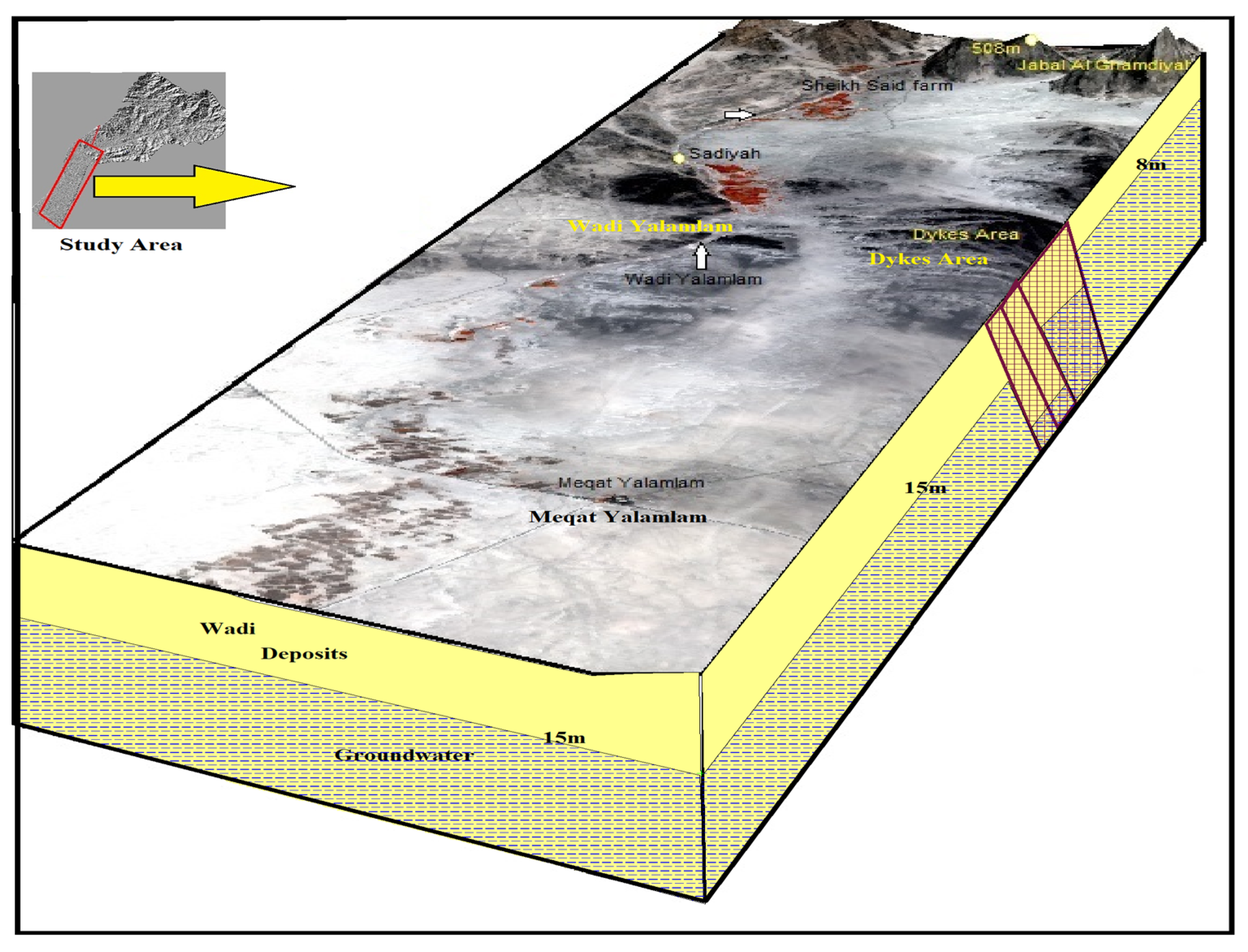
2. Study Area and the Hydrogeological Setting
3. Materials and Methods
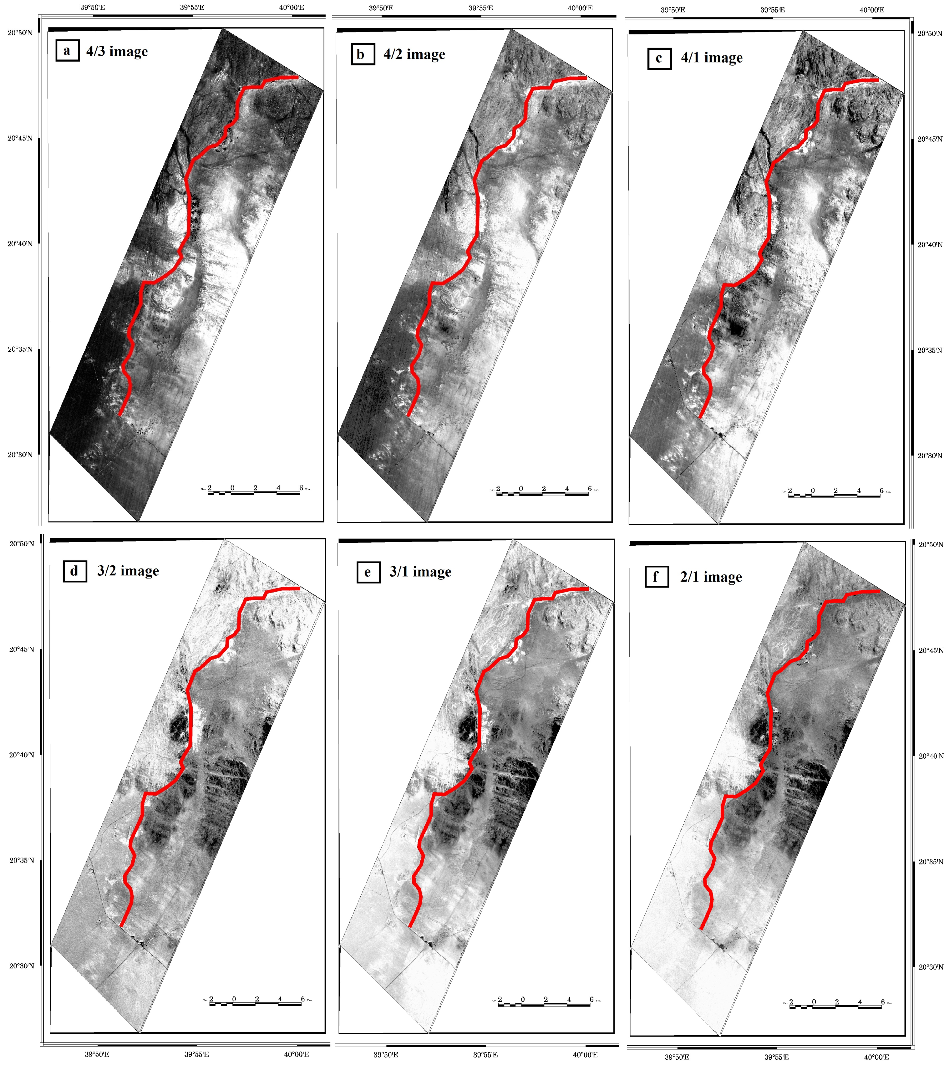
3.1. Explanatory and Dependent Variables
3.2. Random Forest Algorithm and Model Performance
4. Results
4.1. Collinearity Analysis
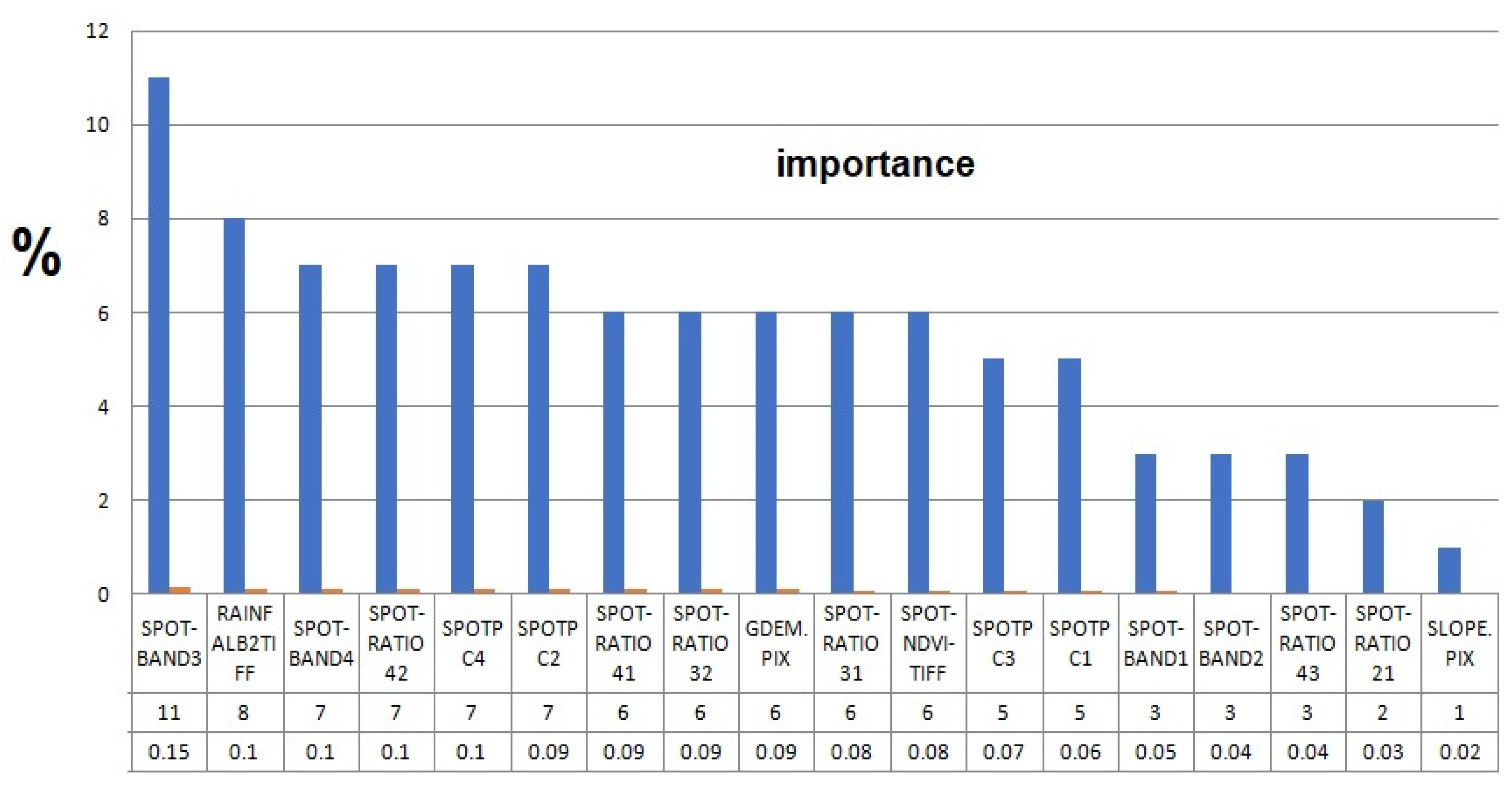
4.2. Variable Importance of Explanatory Variables
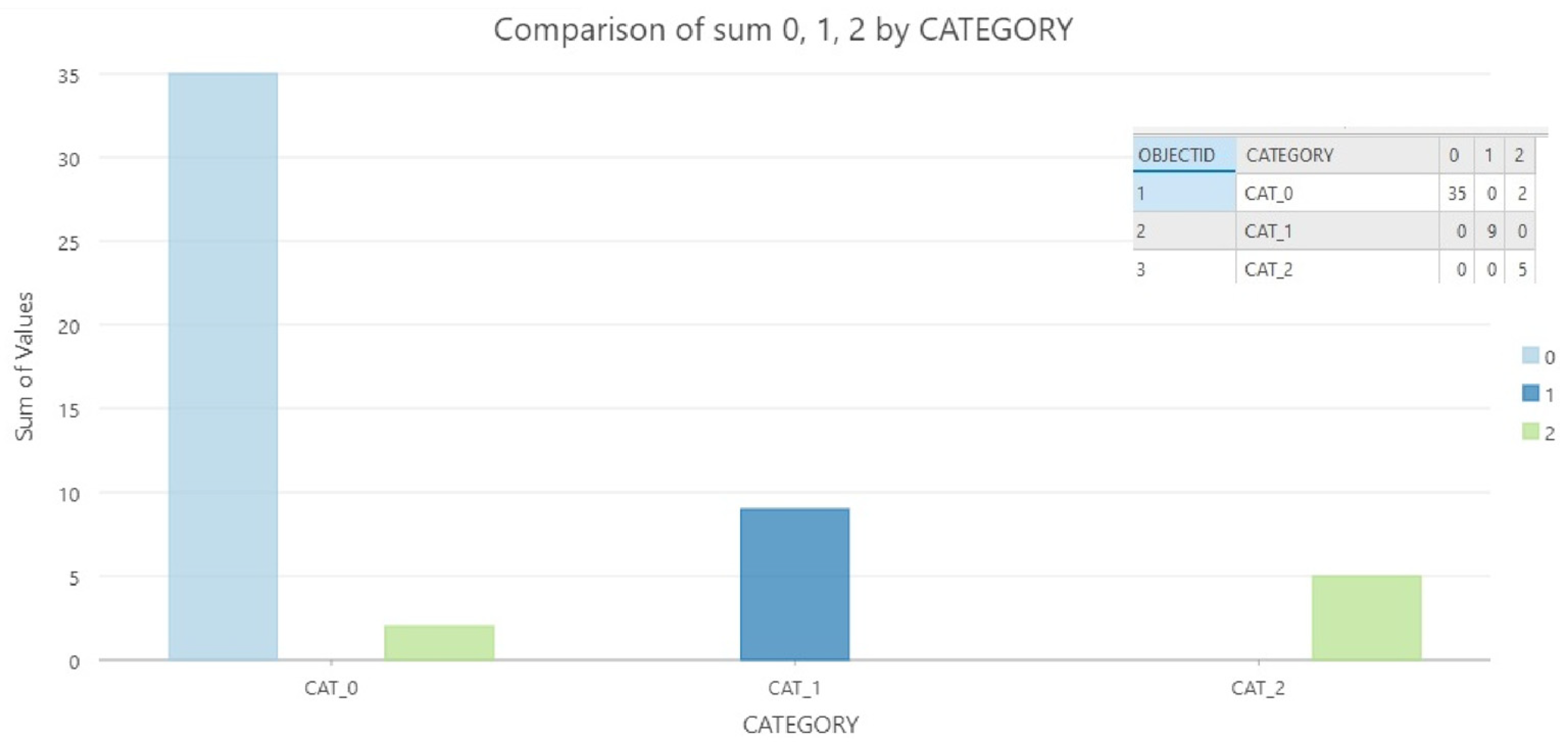
4.3. Random Forest Model Implementation and Generation of GWPM
5. Discussion
6. Conclusions
Author Contributions
Funding
Institutional Review Board Statement
Informed Consent Statement
Data Availability Statement
Conflicts of Interest
References
- Bayumi, T. Quantitative Groundwater Resources Evaluation in the Lower Part of Yalamlam Basin, Makkah Al Mukarramah, Western Saudi Arabia. JKAU Earth Sci. 2008, 19, 35–56. [Google Scholar] [CrossRef]
- Subyani, A.M.; Bayumi, T. Physiographical and Hydrological Analysis of Yalamlam Basin, Makkah Al-Mukarramah area. JKAU Earth Sci. 2001, 13, 151–177. [Google Scholar] [CrossRef]
- Yani, A.M.; Bayumi, T. Evaluation of Groundwater Resources in Wadi Yalamlam Basin, Makkah Area; Unpublished Project No. (203/420); King Abdulaziz University: Jeddah, Saudi Arabia, 2001. [Google Scholar]
- Subyani, A. Study Evaluation of Groundwater Resources in Wadi Yalamlam and Wadi Adam Basins, Makkah Al-Mukarramah, Al-Mukarramah Area. In Proceedings of the International Conference on Water Resources & Arid Environment Riyadh, Riyadh, Saudi Arabia, 5–8 December 2004. [Google Scholar]
- Madani, A.; Niyazi, B. Groundwater potential mapping using remote sensing 897 techniques and weights of evidence GIS model: A case study from Wadi Yalamlam 898 basin, Makkah Province, Western Saudi Arabia. Environ. Earth Sci. 2015, 74, 5129–5142. [Google Scholar] [CrossRef]
- Madani, A.A.; Niyazi, B.; Elfakharani, A.; Osman, H. The effects of structural elements on groundwater of Wadi Yalamlam, Saudi Arabia using integration of remote sensing and airbornemagnetic survey. Earth Syst. Environ. J. 2019, 3, 301–312. [Google Scholar] [CrossRef]
- Rajmohan, N.; Masoud, M.; Niyazi, N. Appraisal of groundwater quality and health risk in the Yalamlam basin, Saudi Arabia. Environ. Sci. Pollut. Res. 2022, 29, 83653–83670. [Google Scholar] [CrossRef]
- Arulbalaji, P.; Padmalal, D.; Sreelash, K. GIS and AHP Techniques Based Delineation of Groundwater Potential Zones: A case study from Southern Western Ghats, India. Sci. Rep. 2019, 9, 2082. [Google Scholar] [CrossRef]
- Mallick, J.; Khan, R.A.; Ahmed, M.; Alqadhi, S.D.; Alsubih, M.; Falqi, I.; Hasan, M.A. Modeling Groundwater Potential Zone in a Semi-Arid Region of Aseer Using Fuzzy-AHP and Geoinformation Techniques. Water 2019, 11, 2656. [Google Scholar] [CrossRef]
- Benjmel, K.; Amraoui, F.; Boutaleb, S.; Ouchchen, M.; Tahiri, A.; Touab, A. Mapping of Groundwater Potential Zones in Crystalline Terrain Using Remote Sensing, GIS Techniques, and Multicriteria Data Analysis (Case of the Ighrem Region, Western Anti-Atlas, Morocco). Water 2020, 12, 471. [Google Scholar] [CrossRef]
- Melese, T.; Belay, T. Groundwater Potential Zone Mapping Using Analytical Hierarchy Process and GIS in Muga Watershed, Abay Basin, Ethiopia. Glob. Chall. 2022, 6, 2100068. [Google Scholar] [CrossRef]
- Morgan, H.; Hussien, H.M.; Madani, A.; Nassar, T. Delineating Groundwater Potential Zones in Hyper-Arid Regions Using the Applications of Remote Sensing and GIS Modeling in the Eastern Desert, Egypt. Sustainability 2022, 14, 16942. [Google Scholar] [CrossRef]
- Naghibi, S.A.; Pourghasemi, H.R. A comparative assessment between three machine learning models and their performance comparison by bivariate and multivariate statistical methods in groundwater potential mapping. Water Resour. Manag. 2015, 29, 5217–5236. [Google Scholar] [CrossRef]
- Naghibi, S.A.; Moghaddam, D.D.; Kalantar, B.; Pradhan, B.; Kisi, O. A comparative assessment of GIS-based data mining models and a novel ensemble model in groundwater well potential mapping. J. Hydrol. 2017, 548, 471–483. [Google Scholar] [CrossRef]
- Lee, S.; Hong, S.M.; Jung., H.S. GIS-based groundwater potential mapping using artificial neural network and support vector machine models: The case of Boryeong city in Korea. Geocarto Int. 2018, 33, 847–861. [Google Scholar] [CrossRef]
- Nguyen, P.T.; Ha, D.H.; Jaafari, A.; Nguyen, H.D.; Van Phong, T.; Al-Ansari, N.; Prakash, I.; Le, H.V.; Pham, B.T. Groundwater potential mapping combining artificial neural network and real AdaBoost ensemble technique: The DakNong Province case-study, Vietnam. Int. J. Environ. Res. Public Health 2020, 17, 2473. [Google Scholar] [CrossRef]
- Arabameri, A.; Lee, S.; Tiefenbacher, J.P.; Ngo, P.T.T. Novel ensemble of MCDM-Artificial Intelligence techniques for groundwater potential mapping in arid and semi-arid regions (Iran). Remote Sens. 2020, 12, 490. [Google Scholar] [CrossRef]
- Martínez-Santos, P.; Renard, P. Mapping Groundwater Potential Through an Ensemble of Big Data Methods. Groundwater 2020, 58, 583–597. [Google Scholar] [CrossRef] [PubMed]
- Moghaddam, D.D.; Rahmati, O.; Panahi, M.; Tiefenbacher, J.; Darabi, H.; Haghizadeh, A.; Haghighi, A.T.; Nalivan, O.A.; Bui, D.T. The effect of sample size on different machine learning models for groundwater potential mapping in mountain bedrock aquifers. Catena 2020, 187, 104421. [Google Scholar] [CrossRef]
- Singh, R. Assessing the impact of drought conditions on groundwater potential in Godavari Middle Sub-Basin, India using analytical hierarchy process and random forest machine learning algorithm. Groundw. Sustain. Dev. 2021, 13, 100554. [Google Scholar]
- Morgan, H.; Madani, A.; Hussien, M.; Nassar, T. Delineating Groundwater Potential zones using an ensemble machine learning model for groundwater management sustainability of East Idfu–Esna Region, Nile Valley, Upper Egypt. Geosci. Lett. 2022, 14, 16942. [Google Scholar]
- Bai, Z.; Liu, Q.; Liu, Y. Groundwater potential mapping in Hubei region of China using machine learning, ensemble learning, deep learning and AutoML methods. Nat. Resour. Res. 2022, 31, 2549–2569. [Google Scholar] [CrossRef]
- Kumar, C.P. Estimation of natural ground water recharge. ISH J. Hydraul. Eng. 1997, 3, 61–74. [Google Scholar] [CrossRef]
- Jyrkama, M.I.; Sykes, J.F.; Normani, S.D. Recharge estimation for transient ground water modeling. Groundwater 2002, 40, 638. [Google Scholar] [CrossRef] [PubMed]
- Madani, A.A. Geological Studies and Remote Sensing Applications on Wadi Natash Volcanic, Eastern Desert, Egypt. Ph.D. Thesis, Faculty of Science, Cairo University, Cairo, Egypt, 2001. [Google Scholar]
- Madani, A.A. Knowledge-driven GIS modeling technique for gold exploration, Bulghah gold mine area, Saudi Arabia. Egypt J. Remote Sens. Space Sci. 2011, 14, 91–97. [Google Scholar] [CrossRef]
- El Sobky, M.A.; Madani, A.A.; Surour, A.A. Spectral characterization of the Batuga granite pluton, South Eastern Desert, Egypt: Influence of lithological and mineralogical variation on ASD Terraspec data. Arab. J. Geosci. 2020, 13, 1246. [Google Scholar] [CrossRef]
- Drury, S. Image Interpretation in Geology, 2nd ed.; Chapman and Hall: London, UK, 1993. [Google Scholar]
- Breiman, L. Random Forests. Mach. Learn. 2001, 45, 5–32. [Google Scholar] [CrossRef]
- Carranza, E.J.; Laborte, A.G. Random forest predictive modeling of mineral prospectivity with small number of prospects and data with missing values in Abra (Philippines). Comput. Geosci. 2015, 74, 60–70. [Google Scholar] [CrossRef]
- Prasad, P.; Loveson, V.J.; Kotha, M.; Yadav, R. Application of machine learning techniques in groundwater potential mapping along the west coast of India. GISci. Remote Sens. 2020, 57, 735–752. [Google Scholar] [CrossRef]
- Martínez-Santos, P.; Díaz-Alcaide, S.; De la Hera, A.; Gomez-Escalonilla, V. A multi-parametric supervised classification algorithm to map groundwater-dependent wetlands. J. Hydrol. 2021, 603, 126873. [Google Scholar] [CrossRef]
- Dormann, C.F.; Elith, J.; Bacher, S.; Buchmann, C.; Carl, G.; Carré, G.; Marquéz, J.R.G.; Gruber, B.; Lafourcade, B.; Leitão, P.J.; et al. Collinearity: A review of methods to deal with it and a simulation study evaluating their performance. Ecography 2013, 36, 27–46. [Google Scholar] [CrossRef]
- Van Beijma, S.; Comber, A.; Lamb, A. Random forest classification of salt marsh vegetation habitats using quad-polarimetric airborne SAR, elevation and optical RS data. Remote Sens. Environ. 2014, 149, 118–129. [Google Scholar] [CrossRef]
- Angelis, L.; Stamelos, I. A simulation tool for efficient analogy based cost estimation. Empir. Softw. Eng. 2000, 5, 35–68. [Google Scholar] [CrossRef]
- Pedregosa, F.; Varoquaux, G.; Gramfort, A.; Michel, V.; Thirion, B.; Grisel, O.; Blondel, M.; Prettenhofer, P.; Weiss, R.; Dubourg, V.; et al. Scikit-learn: Machine Learning in Python. J. Mach. Learn. Res. 2011, 1045, 2825–2830. [Google Scholar]
- Huang, J.; Li, Y.F.; Xie, M. An empirical analysis of data preprocessing for machine learning-based software cost estimation. Inf. Softw. Technol. 2015, 67, 108–127. [Google Scholar] [CrossRef]
- Zheng, A.; Casari, A. Feature Engineering for Machine Learning; O’Reilly Media, Inc.: Sebastopol, CA, USA, 2018; p. 218. [Google Scholar]


| Satellite | Processing Procedures | Data Used in RF Model | Satellite | Processing Procedures | Data Used in RF Model |
|---|---|---|---|---|---|
| SPOT 5 | Enhancement | Band1 Band2 Band3 Band4 | SPOT 5 | Band Ratio | 4/3 BR image 4/2 BR image 4/1 BR image 3/2 BR image 3/1 BR image 2/1 BR image |
| SPOT 5 | NDVI = B3 − B2/B3 + B2 | NDVI image | SPOT 5 | PCA | PC1 PC2 PC3 PC4 |
| TRMM | --------- | Rainfall | ASTER GDEM | ------------ | elevation Slope |
| Variable | Training | Validation | Prediction | Share | |||||
|---|---|---|---|---|---|---|---|---|---|
| Minimum | Maximum | Minimum | Maximum | Minimum | Maximum | Training a | Validation b | Prediction c | |
| SPOT PC 1 | 0.00 | 251.35 | 0.00 | 224.28 | 0.00 | 255.00 | 1.00 | 0.89 | 1.01 |
| SPOT-NDVI | 0.00 | 255.00 | 0.00 | 255.00 | 0.00 | 255.00 | 1.00 | 1.00 | 1.00 |
| SPOT PC2 | 0.00 | 254.52 | 0.00 | 227.68 | 0.00 | 255.00 | 1.00 | 0.89 | 1.00 |
| SPOT PC3 | 0.00 | 255.00 | 0.00 | 255.00 | 0.00 | 255.00 | 1.00 | 1.00 | 1.00 |
| SPOT PC4 | 0.00 | 250.78 | 0.00 | 242.98 | 0.00 | 255.00 | 1.00 | 0.97 | 1.02 |
| RAINFALL | 65.00 | 255.00 | 105.00 | 255.00 | 0.00 | 255.00 | 1.00 | 0.79 | 1.34 |
| SPOT-BAND4 | 0.00 | 253.25 | 0.00 | 223.10 | 0.00 | 255.00 | 1.00 | 0.88 | 1.01 |
| SPOT-BAND3 | 0.00 | 255.00 | 0.00 | 226.07 | 0.00 | 255.00 | 1.00 | 0.89 | 1.00 |
| SPOT-BAND2 | 0.00 | 249.35 | 0.00 | 220.63 | 0.00 | 255.00 | 1.00 | 0.88 | 1.02 |
| SPOT-BAND1 | 0.00 | 245.60 | 0.00 | 229.91 | 0.00 | 255.00 | 1.00 | 0.94 | 1.04 |
| GDEM | 0.00 | 313.26 | 82.33 | 373.03 | 0.00 | 622.42 | 0.84 | 0.74 | 1.99 |
| SLOPE | 0.00 | 38.72 | 1.05 | 33.53 | 0.00 | 81.50 | 1.00 | 0.84 | 2.10 |
| SPOT-RATIO 2/1 | 0.00 | 255.00 | 0.00 | 255.00 | 0.00 | 255.00 | 1.00 | 1.00 | 1.00 |
| SPOT-RATIO 3/1 | 0.00 | 255.00 | 0.00 | 255.00 | 0.00 | 255.00 | 1.00 | 1.00 | 1.00 |
| SPOT-RATIO 3/2 | 1.79 | 255.00 | 0.00 | 255.00 | 0.00 | 255.00 | 0.99 | 1.01 | 1.01 |
| SPOT-RATIO 4/1 | 0.00 | 255.00 | 21.21 | 255.00 | 0.00 | 255.00 | 1.00 | 0.92 | 1.00 |
| SPOT-RATIO 4/2 | 5.84 | 255.00 | 34.59 | 255.00 | 0.00 | 255.00 | 1.00 | 0.88 | 1.00 |
| SPOT-RATIO 4/3 | 6.79 | 255.00 | 40.97 | 255.00 | 0.00 | 255.00 | 1.00 | 0.86 | 1.00 |
| Number of Trees | 100 |
| Leaf Size | 1 |
| Tree Depth Range | 1–7 |
| Mean Tree Depth | 3 |
| % of Training Available per Tree | 100 |
| Number of Randomly Sampled Variables | 4 |
| % of Training Data Excluded for Validation | 30 |
| Category | F1-Score | MCC | Sensitivity | Accuracy |
|---|---|---|---|---|
| Low (0) | 0.97 | 0.91 | 0.95 | 0.96 |
| High (1) | 1.00 | 1.00 | 1.00 | 1.00 |
| Moderate (2) | 0.83 | 0.83 | 1.00 | 0.96 |
| Median accuracy 0.961 | ||||
Disclaimer/Publisher’s Note: The statements, opinions and data contained in all publications are solely those of the individual author(s) and contributor(s) and not of MDPI and/or the editor(s). MDPI and/or the editor(s) disclaim responsibility for any injury to people or property resulting from any ideas, methods, instructions or products referred to in the content. |
© 2023 by the authors. Licensee MDPI, Basel, Switzerland. This article is an open access article distributed under the terms and conditions of the Creative Commons Attribution (CC BY) license (https://creativecommons.org/licenses/by/4.0/).
Share and Cite
Madani, A.; Niyazi, B. Groundwater Potential Mapping Using Remote Sensing and Random Forest Machine Learning Model: A Case Study from Lower Part of Wadi Yalamlam, Western Saudi Arabia. Sustainability 2023, 15, 2772. https://doi.org/10.3390/su15032772
Madani A, Niyazi B. Groundwater Potential Mapping Using Remote Sensing and Random Forest Machine Learning Model: A Case Study from Lower Part of Wadi Yalamlam, Western Saudi Arabia. Sustainability. 2023; 15(3):2772. https://doi.org/10.3390/su15032772
Chicago/Turabian StyleMadani, Ahmed, and Burhan Niyazi. 2023. "Groundwater Potential Mapping Using Remote Sensing and Random Forest Machine Learning Model: A Case Study from Lower Part of Wadi Yalamlam, Western Saudi Arabia" Sustainability 15, no. 3: 2772. https://doi.org/10.3390/su15032772
APA StyleMadani, A., & Niyazi, B. (2023). Groundwater Potential Mapping Using Remote Sensing and Random Forest Machine Learning Model: A Case Study from Lower Part of Wadi Yalamlam, Western Saudi Arabia. Sustainability, 15(3), 2772. https://doi.org/10.3390/su15032772


