Article

Opportunities and Challenges for the Creation and Governance of Productive Landscapes in Urban Transformations: The Case of Klosterøya Urban Fruit Forest Park

by
Maria Olga Tomprou
Faculty of Landscape and Society, School of Landscape Architecture, Norwegian University of Life Sciences, P.O. Box 5003, 1432 Ås, Norway
Sustainability 2023, 15(4), 2864; https://doi.org/10.3390/su15042864
Submission received: 30 August 2022 / Revised: 24 December 2022 / Accepted: 30 January 2023 / Published: 4 February 2023
(This article belongs to the Special Issue Sustainable Urban Open Space Governance and Management)

Abstract

:
Former industrial areas in Europe are being redeveloped into residential and recreational spaces, often including sustainability initiatives. This study explores how the co-governance and management of a productive urban open space contributes to sustainable transformations, and aims to identify the opportunities and challenges that multi-actor design teams face when co-designing sustainable solutions. To achieve this goal, the landscape design process in Klosterøya urban park in Skien municipality, Norway, a privately owned yet publicly regulated park, is used as a case study in co-governance and analysed using the theoretical combined governance and management model developed. Data were collected through the observations of project meetings, document analysis and semi-structured interviews with the multi-actor design team. The results indicated that the working method, through co-creation, produced opportunities for sustainable urban agriculture, enhanced biodiversity, testbeds and water and resource circularities in the landscape, while ensuring a learning process and users’ involvement. Willingness to invest due to the lack of technical knowledge and soil contamination are revealed as key challenges. Conclusions emphasise the significance of co-creative landscape practices for productive urban open spaces and sustainable urban transformations, providing insights for an informed analysis of co-governance cases through the combined governance and management model.

1. Introduction

1.1. Urban Transformations

Contemporary cities in the global north are facing the challenge of accommodating the needs of those dwelling in urbanised areas while providing open and green public spaces. In Norway, specifically, formerly industrial landscapes are being redeveloped and transformed from brownfield sites to residential and recreational areas. Much attention has been paid to the rise in waterfront projects [1], along with the redevelopment of redundant industrial and brownfield sites [2,3]. Both brownfield and waterfront developments in regeneration projects are usually referred to as urban transformation projects, which can be defined as ‘architectural and functional change in urban areas through building activities that require change in the present urban structure’ [4]. Private developers and publicly owned companies working under the same conditions as private companies usually plan and implement these transformational projects.

1.2. Urban Sustainability and Productive Landscapes

Operating under the United Nations Sustainable Development Goals (SDGs) and European Green Deal frameworks, these European urban transformations, at both the landscape and building levels, are usually guided by blue-green visions that combine vegetative areas with water elements, multifunctional spaces and circular economy solutions. More specifically, UN SDG No. 11 calls for making cities inclusive, safe, resilient and sustainable, which includes providing all socioeconomic strata of society with access to green and public spaces [5]. Blue-green spaces, particularly since the COVID-19 pandemic began, are now viewed as fundamental to achieving the UN’s goals, as they can have multiple functions: alleviating heat islands’ effects, reducing biodiversity losses, supporting physical and mental health and contributing to liveability [6]. Transformational projects based on blue-green spaces are mediated by planning policies while being realised on a practical level of landscape design, planning and management.
Within this vision on planning for sustainable urban areas lies an increasing focus in European cities, from both planning agencies and private (grassroots) initiatives, on urban agriculture (UA) integration in urban areas. UA is recognised as a specific type of blue-green concept in the urban fabric [7], with significant potential to serve multiple functions (environmental, social, economic) and create productive landscapes. UA projects are becoming more popular in compact areas in Norway (e.g., Oslo), and Norwegian public authorities are promoting them as a means for local food production, learning and public engagement. European experiences also demonstrate that UA can be used for the sustainable regeneration of urban environments [8,9,10,11] and can contribute to resourceful design and planning that consider and reduce environmental impacts on cities [12].
This resourcefulness is the core element of the theory of regeneration. The term regenerative first was promoted in relation to the use of land by Robert Rodale [13] in an effort to symbolise the enlargement and expansion of his work in organic farming and gardening. John T. Lyle [14] defined regenerative design as design that replaces the present linear system of throughput flows with cyclical flows at sources, consumption centres and sinks. Before this term’s emergence, Bill Mollison and David Holmgren coined the term permaculture in an attempt to define design principles for sustainable human settlements produced in ‘…consciously designed landscapes which mimic the patterns and relationships found in nature, while yielding an abundance of food, fibre and energy for provision of local needs’ [15,16]. The permaculture approach employs ecological design principles and represents a systems design approach to landscape formation, which optimises energy and resource transformation efficiency in many ways. Thus, resourcefulness can be realised through ecological design for closed material and energy flows [17].
Decoupling economic activities based on landscapes from linear, industrial-based material flows lies at the core of circular economy ambitions. By considering the reuse of resources (water, energy and materials/waste), the landscape has the potential to accommodate circular flows in synergistic interactions with flora, fauna and soil. In this sense, urban parks that focus on UA, coupled with a vision for social change, can become a multifunctional green structure that promotes a regenerative resource landscape design. This can be relevant in urban transformations, in which previously industrial lands impacted by anthropogenic activities become revitalised through urban development strategies that emphasise sustainable green pathways. This paper examines the landscape design process for an urban park in a Norwegian context.

2. Theoretical Framework

2.1. The Combined Governance and Management Model

The theoretical framework used for the analysis of the case study in this paper was the combined governance and management (G&M) model of urban open space (UOS), developed by Jansson et al., (2018) [18]. Jansson defined urban open space as an unbuilt area within a populated settlement comprising a combination of vegetated (‘green’), water-dominated (‘blue’), derelict (‘brown’) and/or hard-surfaced (‘grey’) elements [19]. UOSs vary from playgrounds to highly maintained parks to informal and natural landscapes located in urban and peri-urban settings that often are publicly accessible [18,20,21]. The combined G&M model, depicted in Figure 1, contains the four dimensions of a governance arrangement [22]—actors (e.g., users, designers, managers, administrators), power and resources (depicted using arrows from actors towards the UOS), rules of the game (depicted in boxes next to users and administrators) and discourses (depicted through arrows between users and administrators)—that form and amend an urban open space’s management process. The object of management (UOS) can be differentiated on a governance-type axis from hierarchical to self-governance (placement of arrows). In the Norwegian case in this study, the object is placed in the middle of the governance type axis, indicated by the term co-governance, as it is a privately owned, yet publicly regulated park (marked with a blue circle in Figure 1).
As the G&M model is anchored in the physical UOS, it can be used to investigate and elaborate on management practices within the contextual parameters and core dimensions of governance arrangements [20,23]. Thus, the G&M model can be used to discuss overarching discourses, including UOS qualities shaped by actors and their resources, as well as framed by policies, by placing management in relation to governance and encouraging new forms of open space management practices. In the case of this paper, the management practice is a co-creative, co-developed and co-governance UOS model: an urban park based on UA. The researcher adopts the definition of co-creation by Sanders et al., 2008 [24] and takes co-creation to refer to any act of collective creativity, i.e., creativity that is shared by a group of people. Co-creation in design fields is understood as a mindset for creative participatory practice, and design co-creation emphasises the collaborative, generative creative participation of individuals in design-led workshops and group practices [25] and is therefore considered to be the working method in the Norwegian case study.
The discussion above takes place at a certain time during the project’s lifetime upon completion of the landscape design phase, allowing for a detailed description in a temporary stabilisation of the project’s specific governance and management arrangements. This is viewed as significantly practical, as it provides a foundation for the analysis of the phases in the project’s early design process, as well as the next phases, during which the UA and other blue-green elements will be established. The findings can uncover the opportunities, challenges and barriers associated with the process of designing for sustainability and circularities during the landscape design phase. What is learned can be tested in other cases, or subsequent phases of the co-design and co-development of the UOS in this specific case.

2.2. New Co-Governance Approaches to Landscape Design and Management of Productive UOS

In these new types of co-development, new co-governance approaches appear more flexible and collaborative than either private initiatives or public urban open spaces [26]. Any type of landscape intervention—from its design, planning and maintenance until implementation, landscape formation and construction—contains a crucial aspect of governance manifested in actors’ actions, practices and overarching policies and powers. Even though this paper’s analysis focusses on actual practical challenges in the landscape design process, understanding specific governance arrangements during the early design phases can contribute to a better understanding of the challenges and knowledge gaps that must be tackled, eventually eliciting discussions within urban sustainability discourse.
Landscape architecture projects often comprise three distinct phases—planning, design and management [18,20,27]—implying and adopting a linear logic and chronological hierarchical order. Thus, they usually progress within a planning policy framework set by authorities toward initial and detailed designs that lead to construction or planting, as management practices are implemented during the end phase [19]. The use of the combined G&M model also allows for a more dynamic approach to codeveloping landscape qualities compared with the usual linear logics of landscape project development.
Apart from this dynamic approach, the model allows for a descriptive analysis of a landscape design process through the descriptions of all elements in the design, management and planning dimensions to provide a better understanding of their interrelations and, thus, the process itself. The model’s use can challenge common divisions between UOS management (or place keeping) and design and planning (place making) that are often obvious among public authorities and academia. However, these aspects are often intertwined in practice [28,29] and can have vague borders as management adds elements from planning, design and feedback to their planning practice [28]. The descriptive analysis of the specific case study using the combined G&M model can help showcase specific opportunities and barriers associated with the temporal governance stabilisation of the UOS during the landscape design phase. This can help us learn from the specific contemporary example and bring forth the relationships and topics worth testing over time or in different cases and contexts. This can provide another contribution to sustainability and circular economy discourse in urban transformations within Norwegian cities.

2.3. Objective

This paper examines the formation of a productive landscape in a transformation area in Skien, Norway, with an objective to explore how the co-governance and management of a productive urban open space contributes to sustainable urban transformations. To achieve this goal, the early landscape design process in the project’s landscape formation was analysed using the combined G&M model [18]. The main research question was: What opportunities and challenges related to sustainable solutions did the multi-actor design team meet during the early phase of the landscape design process?

3. Methodology

To examine this, the study employed a detailed case study analysis of the Klosterøya UOS. To investigate the opportunities and challenges in designing productive landscapes in the UOS, the landscape design process was analysed with the help of the combined G&M model through data from document analysis and interviews. This chapter first describes the case study, presenting information about the site and how the specific case was selected. Then, data collection methods are presented, along with an explanation of the landscape design process timeline.

3.1. Case Study

3.1.1. Case Study Selection

The paper is based on a single case study analysis of the landscape design process involving Tømmerkaia urban park in Klosterøya, Skien municipality, in Norway, which is undergoing a post-industrial urban transformation. The rationale for selecting the case was twofold: an emphasis on sustainability through UA and on co-creation (samskaping in Norwegian). The UOS project had a sustainability vision described in an early feasibility study published in 2019 [30]. The project examined UA as a potential multifunctional structure in the formation of an urban park landscape, integrating environmental, social and economic sustainability based on the same study. This vision corresponded with a previous emphasis on UA, as Skien was one of the first municipalities in Norway to establish a municipal UA strategy [31]. Permaculture design, among others, inspired Klosterøya UOS’ feasibility study at that point and put focus on sustainable productive landscapes and healthy soils. Furthermore, the examined UOS is a privately owned, yet publicly regulated area, which has elicited interesting governance constellations of actors who co-creatively designed, managed and planned solutions for the UOS as a multi-actor team.
Thus, Klosterøya can be viewed as a critical case study [32] that can contribute to knowledge about real-life landscape projects that aim for productive co-design landscapes. How the UOS is being designed, planned and managed as productive space during the early landscape design phase is unpacked below through the analyses of interviews. The project takes place in a representative, medium-size Norwegian city undergoing urban transformation; therefore, the research focuses on a context outside of the capital city of Oslo.

3.1.2. Case Study Description

Klosterøya in Skien has a historical significance, with its origins dating back to a medieval monastery, Gimsøy Abbey (1110–1540), the first monastery in Norway founded by women. Gimsøy Abbey, depicted in Figure 2, had a self-sustainable character combining agriculture with cyclical resource management. Norway’s king ordered the destruction of Gimsøy Abbey by fire in approximately 1540. The nuns abandoned the site, which was cleared, with the crown seizing the land, which became state property. However, historical research on cloister garden plants indicates that seeds from medieval times have survived, allowing researchers to recreate the gardens and determine the possible uses for the plants in the monastery’s everyday life [33]. The cloister gardens and the nuns’ sustainable ways of living are crucial elements that the design team wanted to utilise in the contemporary formation of the UOS in an attempt to revive the sustainability practices of the past.
These sustainable practices were eradicated with the rise of industrial activity (paper and wood industry) in Klosterøya starting in 1546, when a sawmill was established and the first Gimsøy dollar was produced in Klosterøya. Then, in the 1600s, the logging industry started floating logs down the river. By the 1850s, the area’s first industrial companies were involved in hydropower and wood processing. The sawmill, paper manufacturing and log driving transformed the island into an industrial hub. In 1916, the Union Skien Paper factory purchased the land, and the mill’s two paper machines produced 240,000 tons of newsprint and book paper annually. The factory was decommissioned in 2005. The name of the waterfront (Tømmerkaia) reveals the area’s industrial history, as tømmer means timber in Norwegian, and kaia means waterfront. The industrial activity in Klosterøya is a historical layer visible in the area’s historical buildings (see Figure 3), but with invisible impacts: The contaminated soil as a result of heavy anthropogenic industrial activity remains an important issue in the urban development of preindustrial sites.
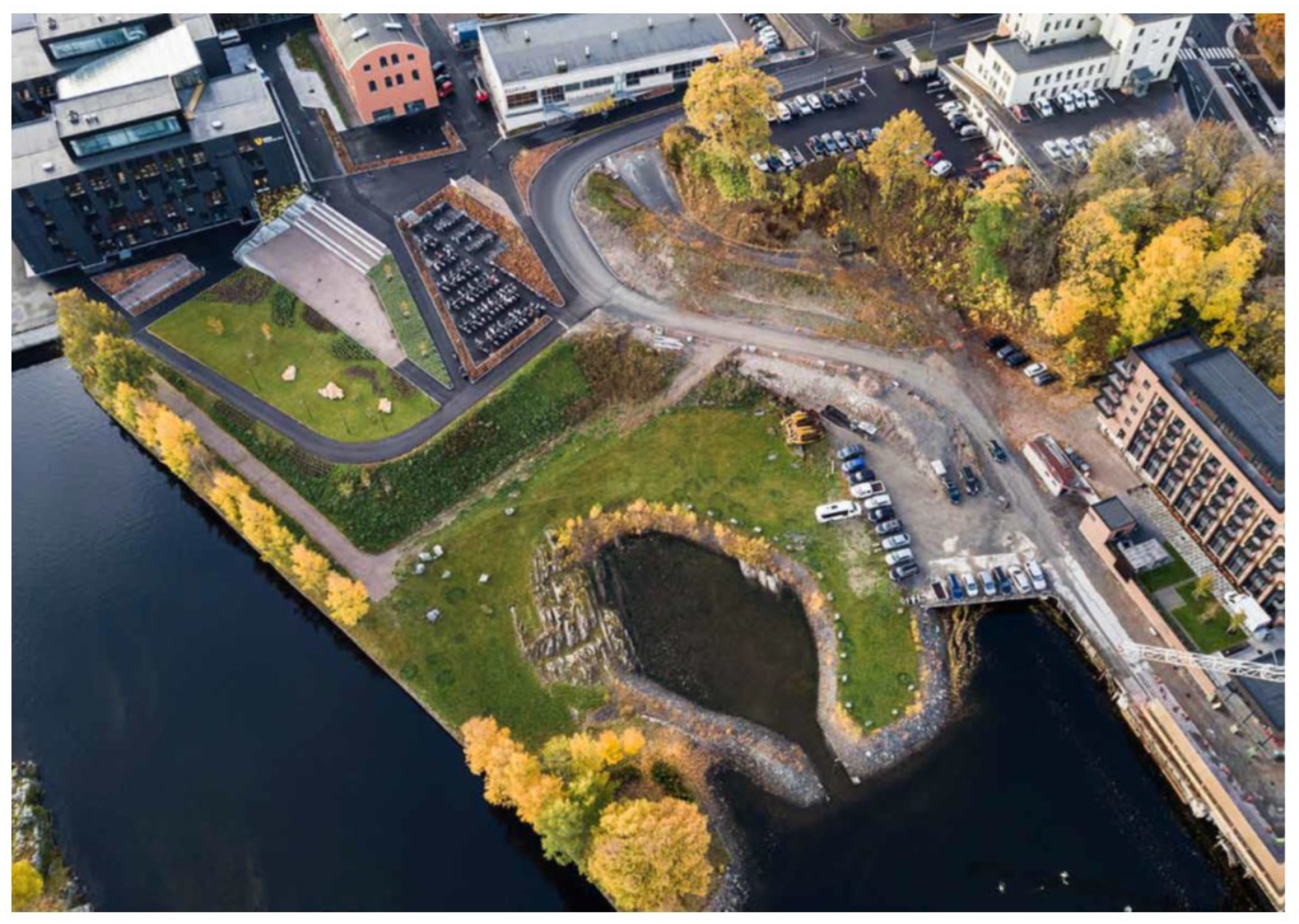
Klosterøya’s urban transformation aims to create a new neighbourhood comprising mixed residential, cultural and commercial uses. Developer Steinar Moe purchased Tømmerkaia in 2016 and submitted plans for a major city redevelopment project. The developer also aimed to create a publicly regulated urban park in Tømmerkaia, the east part of Klosterøya that is the UOS examined, as depicted in Figure 4. The park being designed and developed in this area has been touted as the area’s first new municipal park in two centuries; therefore, it is important for the area, particularly its direct neighbour: Skien High School.

3.1.3. The Landscape Design Process of Klosterøya UOS

The researcher, after consulting with the design team, divided the landscape design process into three phases, as indicated in Figure 5. The phases do not have a strictly defined chronological period; therefore, they are indicated roughly in the timeline. Between 2018 and late 2021, the landscape design team worked co-creatively on various landscape design ideas for blue-green structures for the UOS. Prior to this, in 2017–2018, the design team planned and conducted co-creative workshops on a variety of themes. The workshops comprised a separate phase before the researcher’s doctoral studies began. The researcher then worked as an environmental consultant and was invited to participate in the surveys and workshop on contaminated soil. This case study’s data collection began upon initiation of the doctoral studies. The researcher as consultant’s prior involvement comprises a distinct phase that is irrelevant to this study, but helps provide easier and more direct access to project participants.
Phases 1 and 2 correspond to the common division of the landscape architecture and building projects: Phase 1 is usually a concept development phase during which all relevant standards are reviewed, the necessary expertise is discussed and basic landscape concepts are designed. In the specific project, Phase 1 focussed on the main landscape structures. Phase 2 usually corresponds to the detail phase, during which all structures need to be designed in detail for the project to be implemented. Phase 1, in the specific project, represents the final phase, in which all structures were codesigned. In September 2021, the early landscape design phase was concluded with a project status meeting, then data collection ended in August 2022.

3.2. Data Collection Methods

3.2.1. Document Analysis

The purpose of the document analysis is to provide data for the urban development’s planning context, as well as a framework for the sustainability vision for the transformation to build up the frame for the discourses in the specific case examined. The documents reviewed in relation to this paper were:
  • Municipal plans for the development in Klosterøya East;
  • Feasibility study for Klosterøya East that the design team produced in 2018;
  • Landscape design drawings coproduced by the design team during a series of meetings and time frames;
  • Minutes from meetings;
  • Other documents published in relation to the specific urban development.

3.2.2. Interviews

The interviews provide a deeper understanding of the opportunities and challenges that the landscape design team faced throughout the early design process. The researcher interviewed the seven members of the multidisciplinary design team, henceforth called participants. All participants provided informed consent to be interviewed, and the Norwegian Centre for Research Data (NSD) approved the study.
Altogether, six semi-structured qualitative interviews were conducted with each participant of the landscape design team in March 2021 and April 2022, focussing on the landscape design process and the opportunities and challenges that the team faced. The interviews lasted 35–40 min each, and the participants comprised the landscape architect and project leader for the landscape formation of UOS, a Skien High School teacher, a Skien community-supported agriculture (CSA) representative, county government representative, a representative for the private developer and a permaculture expert. In addition to these interviews, a one-hour focus group interview was also conducted with the project’s leader and the CSA and municipal and state government representatives, focussing on edible rain gardens and surface water management.
During the semi-structured interviews, the participants were shown representative landscape design drawings from each phase and were asked to elaborate on the challenges they faced and the opportunities they identified when designing for sustainability and circularities in the landscape. The researcher developed an interview guide that included the main topics to be discussed. When conducting these interviews, the researcher loosely adhered to the interview guide to ensure that the core topics of the research questions were addressed. However, the discussions were mainly guided by what the researcher viewed as meaningful to participants and would often weave in and out of different topics [34].

3.3. Data Analysis

For the data analysis, the interviewer summarised the interviews’ content, extracting all voice information, concerns, perceptions and ideas related to the research question mentioned above, using field notes and audio recordings generated during these activities.
Adopting Braun and Clarke’s (2006) [35] methodological guide, a thematic top-down analysis of the interview transcripts, driven by the main research question, was conducted. Quotes from the interviews that reflected these themes were selected and used in this paper to support and enhance the research narrative. The last meeting with the main design team that was documented concluded the project’s first phase, taking place on 24 September 2021 at Skien High School, during which the researcher received a project status update, the team’s new configuration and the plan for subsequent phases.

4. Results: Opportunities and Challenges in the Landscape Design Process

To understand better how the co-governance of Klosterøya productive UOS contributes to sustainable urban transformation, the three phases of the landscape design process (feasibility phase and Phases 1 and 2) were analysed with the help of the combined G&M model. The opportunities and challenges for designing sustainable solutions, identified during each phase through data collection, are presented in the following subsections.

4.1. Feasibility Phase: The Green Model

The feasibility phase represents mostly opportunities for circular and productive landscapes, ecological design in line with nature and the coproduction of spaces for learning and social interaction, as illustrated in the landscape plan codesigned during this phase, depicted in Figure 6.

4.1.1. Opportunities for Ecological Landscape Design through UA

Sustainable UA was the main inspiration for Klosterøya UOS, forming part of the general discourse within the municipality and Telemark County government (a public actor in the G&M model; see Figure 7). In 2018, the developer (a private actor in the G&M model) assigned coordination of the landscape formation for the park project to the landscape architect and project leader (a private actor in the G&M model). As the landscape architect was previously employed by the municipality, working on fostering UA in the area, this created strong professional and personal relationships, as well as common visions, among the actors. Based on the interview with the landscape architect, the county had a vision to be one of the country’s most innovative counties for urban and peri-urban agricultural initiatives [31]. This created fertile ground on which to welcome new projects that focus on UA. Regarding actual UA implementation, the CSA representative in Skien, Århus gård (a private actor in the G&M model), became involved in the project through a direct appointment from the project leader. Århus gård had expertise and interest in UA ecological production and was previously involved actively in learning processes with Skien High School (a public actor in the G&M). As the whole waterfront area would be developed to accommodate student apartments, the tenants would be the main UOS user group. Furthermore, Tyrili stiftelsen (a private actor in the G&M model), a non-profit organisation and rehabilitation centre in Skien, and Spriten Art Hall (a public actor in the G&M model), a cultural institution, are also immediate neighbours and users of the area who were engaged during the feasibility phase and became interested in engaging with UA activities in the UOS.
The main green element inspired by ecological landscape design was the urban fruit forest, based on permaculture, that covers an area of roughly 600 m2 in the UOS. Permaculture design is based on resourcefulness landscape processes that rely on nature’s ability to regenerate while reusing materials and resources. Permaculture was viewed as an opportunity for circularity and ecological design, according to the permaculture expert participant (a private actor in the G&M model). The landscape formation in the terraces that the design team proposed would direct water flows and runoff to vegetated areas in the urban fruit forest, in line with permaculture recirculation principles. The Skien High School teacher and interview participant acknowledged the inherent function of utilising urban water flows in the proposed landscape plan for the urban forest: ‘…The structure of the urban forest provides the opportunity to utilise urban runoff. This is made possible by the selection of permaculture design, so that all surface water can be used in the planned fruit forest….’ Therefore, the fruit forest would also maintain itself through a selection of plants, trees and perennial species that would be planted, allowing for an evolving landscape design process.

4.1.2. Opportunities for Learning and Social Interaction

The landscape design team viewed the UOS as a platform for learning and social interaction. Based on interviews with the landscape architect, the emphasis was on engaging arts and crafts in this UOS. The high school, in collaboration with the artists, developed the concept of the ‘outdoor classroom’ (uteklasserom in Norwegian)—an idea for utilising the UOS in Tømmerkaia as an outdoor learning space for Skien High School students with a vision for a long-term collaboration between artists and teachers. Different labs were planned as part of this concept. The ‘Biolab’ focussed on UA’s environmental aspects, and the students worked with the seeds, plants, contamination issues in industrial soils and biodiversity assessments. The conceptual art installation comprises a Transect, Pyrolab and website (www.uteklasserom.no, accessed on 24 December 2022) for the dissemination of the project’s information [30]. The Transect method requires an observer to move along a fixed path and count occurrences along the path. The line created physical information points across Klosterøya. The Pyrolab would be at the heart of the outdoor classroom, comprising an installation with a rock floor, workbenches and an outdoor oven. The artists and students investigated how the geology looks under the park and created a model. In this way, the landscape was co-developed in a more dynamic way, eliciting participation from both artists and the school. Furthermore, a paper-making lab and greenhouse, as part of the school’s learning curriculum, were planned to be established in either the new buildings or on school property. Through all these activities, the landscape design team provided the landscape formation of the UOS as a platform for social sustainability, with an emphasis on learning and arts. Therefore, the sustainability discourse was shaping the envisioned opportunities, as depicted in the representation of the Green G&M Model in Figure 7.

4.2. Phase 1: The Blue Model

The blue element, i.e., the water in the park (Figure 8), dominated this phase. The discussion’s focus during this phase among the design team was the wetland and surface water management in the park. Water has been viewed as a historical element since the Middle Ages and, thus, important to keep in the park. This wetland would provide a natural opening to open waters, which were filled with soil masses and timber during the industrial era. Figure 9 represents the combined G&M representation of Phase 1—the Blue Model—in which opportunities and challenges are depicted schematically, then explained further below.

4.2.1. Opportunities for Enhanced Biodiversity

The CSA representative emphasised this wetland’s importance for the park’s biodiversity: ‘This type of a wetland is extremely important to have in the park. Despite the fact that Klosterøya is surrounded by water, this water is in a constant flow, and that is not favourable for a lot of insects that prefer more still waters...’. The school also saw big potential in having the wetland, both for enhancing biodiversity and using it for learning ‘…to create a wetland, a blue heart in the area, that will be a social meeting point and rich in leaning potential...’. Simultaneously, the school was trying to provide solutions for the irregular water flow in the wetland by working with students on innovations for a micro-hydro power unit that would be connected to the waterway, including a rain garden with outflow on a wetland, following the natural outlet to the open water.

4.2.2. Opportunities for Circularities (Water and Waste)

Apart from the circularities in resources, e.g., urban runoff and rainwater, the design team visualised the circular flows of materials and energy on the site. Food waste from the school cantina was used as compost for the UA on site. Several mushroom (fungi) farm workshops were also conducted with the students, during which mushrooms were implanted in tree trunks to increase awareness of these species’ role in creating closed resource loops in the UOS. The urban fruit forest’s edible crops would be accessible to all, particularly direct users of the UOS, including the school canteen, school students, apartment tenants and Tyrili stiftelsen, supporting in this way no-distance travel from the source to consumption within the frame of a circular economy and sustainability.
During this phase, the design team acknowledged the opportunities for circularities in connection with the new (student apartments) and existing building masses: Rainwater from the roofs was identified as the main reusable resource in the park. The design team also recognised the possibility of using rainwater from the existing school building, as well as urban runoff from the existing cycle parking lot, which is the park’s highest point. In this way, the team wished to decouple the runoff from the pipe system by leading it to a natural flow and towards the vegetated areas.

4.2.3. Opportunities for Test Beds: Edible Rain Gardens

The focus group interview aimed to identify opportunities for sustainable surface water management through edible rain gardens. The design team viewed edible rain gardens as a blue-green structure that would provide a natural cleansing of contaminated urban runoff through edible plants. The CSA representative on the design team emphasised the importance of regenerating the soil with the help of plants, stating, ‘The remediation of contamination, especially with plants, called phytoremediation, can be relevant in our case and in so many other cases of urban transformations, where contaminated soils can be revitalised’. The municipal representative, in an attempt to support experimentation with edible rain gardens, stated: ‘…Let’s remind us the milk campaign we had here in Norway—“best before, but also good after (the expiry date)”. We are all willing to eat berries that grow alongside a road…. It will be interesting to explore what are the contamination levels in edible plants in our project’. The edible plants would be monitored through school experiments to support quality standards in edibles. According to the landscape architect, the edibles could also be used alternatively in the paper-making lab that the design team envisioned for the site. In this way, the paper-making history from the industrial era would be revived in a sustainable way in the contemporary UOS.

4.2.4. Challenges: Technical Knowledge

During Phase 1 of the landscape design process, uncertainties remained as to whether this wetland would be filled in due to security and public access issues that the developer was considering, as the developer’s representative stated: ‘The discussion about water in the park has been focussing on the question of the wetland, should we keep it and how can we actually handle it. It is a long way down to the water, the area feels not directly available to the public, yet it is, and it is not secure with regards to small children…’. These concerns reveal an uncertainty on technical issues forming the ‘rules of the game’ mediated by the private actors and depicted in Figure 9. Through consultations among the design team, the developer finally acknowledged this blue-green structure’s significance as an essential element for advancing the park’s biodiversity while providing an experience with close proximity to the water: ‘…Yet, it is water; everybody loves water. It’s a nice element to have in a park!’ This acknowledgment provides a feedback arrow from the landscape design to the private actors in the Blue G&M Model depicted in Figure 9. This arrow is shifting the rules of the game towards implementation of the wetland.

4.2.5. Challenges: Environmental Policy and Urban Surface Water Management

Regarding urban runoff, towards a more sustainable approach to surface water management, big municipalities such as Oslo, the capital city, are posing specific requirements for new urban developments: The developer should provide green areas for locally accommodating stormwater [36]. This requirement ensures that the designers and planners consider this option during the design phase. However, Skien municipality does not have any regulations on the local open management of stormwater in new urban developments and, therefore, does not require specific actions with regard to this. Based on dialogues with the Water Utilities (Vann og Avløp,VA) section in Skien, it was determined that designing for open surface waterways in vegetated areas in new developments can be particularly challenging because the soil masses are contaminated overall. The industrial activity and old landfills in the deeper soil layers can pose risks to the environment, including groundwater bodies, if the surface urban water starts infiltrating through contaminated soils. However, Skien municipality, in a digital meeting with the researcher in March 2021, acknowledged the importance of blue-green structures (e.g., rain gardens) for local infiltration of stormwater as an alternative to pipe systems, and noted that they currently were working with a new municipal master plan that would consider these topics. Thus, the current environmental policy framework in Skien did not yet support a straightforward implementation of sustainable landscape solutions, as no specific requirements were posed. Therefore, environmental policies are viewed as the ‘rules of the game’ mediated from public actors in the Blue G&M Model represented in Figure 9, posing possible implications for the landscape design process.

4.3. Phase 2: The Blue-green Model

This final phase focussed on the structures that connect the elements together in the UOS and how the whole system would function. In the final representation of the landscape plan (Figure 10), the opportunities for circularities and designing with flows are depicted clearly. The plan represents a more systemic approach to the UOS that creates connections and synergistic effects between the blue-green elements and users. The opportunities and challenges during this phase are also depicted schematically in Figure 11.

4.3.1. Opportunities for Systematic Landscape Design

During this final phase, the design team took a more systematic approach, with an emphasis on how all elements could function together. The urban fruit forest would be a structure that, by design principle, would manage to maintain itself in the long term. Edibles would be used directly in the outdoor kitchen or school cantina. The edible rain gardens were viewed as both a climate adaptation measure and UA as a pilot structure and a test bed through which the school can experiment with plants that can tolerate contamination from urban surfaces and conduct relevant contamination measurements through engagement with chemistry students. If the measurements indicated unacceptable contamination levels, the plants from the edible rain garden would be used alternatively in the paper-making lab planned in the new buildings on site. The water circularities would be enhanced by the wetland and the micro-hydropower unit with which the students were experimenting. The micro-hydropower unit would utilise the natural flow of waterways and retrofit energy in the park as power for lighting.
Planning for biodiversity also became more systemic during this phase, as all the structures were viewed as ecosystems that were connected to each other. As the county government representative stated: ‘…What is happening in Klosterøya will provide inspiration for diverse actions for biodiversity in the whole island’. The UOS’ biodiversity was viewed in connection with the surrounding areas by creating bee corridors that connect the UOS in Klosterøya with surrounding areas. The school had initiated a project in which they would place plant modules on different properties, not only owned by Steinar Moe, but also other developers and owners, to provide bee corridors for the whole connecting peninsula and the City of Skien. The systematic landscape design envisioned here provides feedback arrows to the private and public actors, retrofitting the powers and resources that shape the rules of the game in the combined G&M model, as depicted in Figure 11.

4.3.2. Challenges: Financial Resources

For these systems and visions to be implemented and function, careful consideration of technical aspects and knowledge gaps was needed. The developer’s representative acknowledged the challenge with many technical aspects, as well as uncertainties about certain functions: ‘I have too little knowledge of all this (water systems)…. It is hard to know how much water we are really talking about, how much water flow the micro-hydro power needs in order to function, and the flows, as well as the rain garden functions…’. ‘It is a question of what can be done within the project’s budget...’. During the interviews, the developer’s representative acknowledged the importance of sustainability but noted that the project would need to operate within given budget parameters. The willingness to invest in solutions would require a deeper understanding of the function and implementation. Therefore, the financial resources are significant ‘rules of the game’ in the Blue-green G&M Model depicted in Figure 11.

4.3.3. Challenges: Contaminated Soil

The paper industry activity in Tømmerkaia Klosterøya from the industrial era resulted in contaminated soil that, according to Norwegian environmental law and building law, needed to be removed as part of the new urban development. For this reason, environmental soil investigations were required upon initiation of excavation for the development. Environmental consultants investigated the area chosen for the urban fruit forest, and the environmental report compiled from the investigation [37] concluded that the contamination levels in the topsoil masses fell within acceptable levels for human health, but it was recommended that fresh topsoil be transferred to the site where edible species would be planted to minimise the health risks from contaminants that would accumulate in the crops.
During Phase 2, the design team requested clean topsoil masses (matjord) to be transferred and formatted into terraces, which would enable the first planting activities in the urban fruit forest. The developer communicated this to the excavator responsible for terrace formation, who transferred soil masses that contained old industrial waste instead of clean agricultural soils. The researcher, landscape architect, teacher and the CSA representative, who conducted a site inspection of the field, verified this. Both the school and developer acknowledged that these masses were not fit for agricultural activities. The school and CSA would work with the students to improve the soil in the coming months, but this miscommunication elicited discontent from the landscape architect, who resigned from the project.
The developer then entered into a mutual agreement with the school, which would take the lead in the landscape formation of the UOS in subsequent phases. The school wanted to focus on biodiversity, UA, cloister gardens and managing urban runoff in the UOS as main themes, as reported from the final meeting with the researcher. The developer will cover the construction costs for the greenhouse, and the school will continue to design, plan and manage the UOS co-creatively. As the school wanted to implement more blue-green structures in the UOS space, the school acknowledged the importance of funding. Therefore, UOS formation, with an emphasis on UA, has been stabilised in a rather unpredictable predicament, with the school gaining the power to proceed with landscape formation, though with limited resources and manpower as far as necessary landscape design expertise. This can have implications for the project’s subsequent phases.

4.4. Synthesis of Findings

This study’s objective was to explore how the co-governance and management of a productive urban open space contributes to sustainable urban transformations by analysing the early landscape design process in the project’s landscape formation using the combined G&M model. The research question that guided the analysis aimed at identifying opportunities and challenges that the multi-actor design team faced when co-designing sustainable solutions. The results indicated that the design team’s configuration and their working method through co-creation produced opportunities for multifunctional blue-green structures, sustainable UA, enhanced biodiversity, testbeds and water and resource circularities in the landscape, while ensuring a learning process and users’ involvement. However, the more the blue-green structures needed to be considered systemically in the landscape design, the more challenges the design team faced and would need to overcome for these structures to be implemented. Issues, such as a lack of technical knowledge on certain solutions, would affect the developer’s willingness to pay and restrict the financial resources available for all ideas.
Despite this complexity and the challenges that inhibited certain solutions, the UOS in this specific development case has generated much more than a grass lawn in the urban park. The design team has established a close connection to the landscape as a conduit for circularities within the sustainability discourse. Upon the completion of the data selection, the fruit forest terraces have been formatted; the school, CSA and other users can start working with soil improvement; the adjacent building site has been granted permission for construction; and the developer has agreed to fund the construction of a greenhouse to be used for learning activities (outdoor classroom).
The findings emphasise the significance of co-creative landscape practices for productive UOS and sustainable urban transformations. The researcher argues that the co-creative landscape design of the productive UOS can provide feedback arrows between the design practices and actors, discourses and policies that drive urban transformations, allowing for an informed analysis of co-governance cases through the combined G&M (Figure 12). The actual co-creative practices can provide a platform for an ecological landscape design, with an emphasis on UA, learning and crafts that could inform a ‘bottom up’ approach to the design and use of public spaces (blue feedback loops in Figure 12 connecting landscape design with public actors and the rules of the game). The co-creative process in this case also has allowed for better control (blue feedback loops to public actors, Figure 12) of the contaminated masses, raising concerns over the importance of healthy soil for UOS creation. Furthermore, the codesign of blue-green structures as testbeds for innovation (edible rain gardens) can function as a trigger for bottom-up innovations within a given environmental policy framework that does not yet provide the frame for such solutions. Testbeds can thus allow for experimentation for sustainable solutions and provide gradually small policy changes that can lead to sustainable urban transformations. Co-creative landscape design has also ensured the school’s role as a long-term manager, providing feedback loops to the private actors and their rules of the game. The same process can enable the formation of sustainable outdoor green spaces in urban transformations.

5. Discussion

5.1. Bottom-Up Ecological Landscape Design

Through collaborative approaches to landscape formation, with an emphasis on urban agriculture, a productive UOS can help reconfigure more sustainable and resilient cities. This can contribute to the current academic discourses on UA as a pathway to urban resilience [38,39,40]. The permaculture design that inspired the project during the feasibility phase views problems as opportunities for ‘learning by doing’ in line with nature. This may be an interesting practice towards overcoming this dichotomy of recognising either opportunities or challenges and rather encourage a bottom-up design process that supports experimentation and social innovation [41]. Even though the permaculture design was not implemented as such during the subsequent phases, elements of this were obvious in the chosen co-creative landscape design process that focussed on circular solutions in the UOS. Such collaborative initiative on local experimentation at the landscape level can facilitate policy changes [42] and contribute to the debate on the need for more adaptive urban planning that supports ‘safe to fail’ design experiments [43].
Landscape practices that inherently view landscapes as a conduit for social change and environmental sustainability through co-creation have the potential to guide urban sustainability transitions. A more systematic approach dictated by ecological visions in line with nature, in an evolving way, can include new ways of implementing design through knowledge input and collaboration among different actors and through the possibility of the constant development of urban spaces and can therefore contribute actively to this debate [18].
Furthermore, this study emphasises the importance of cultivating of a green space as a process and contributes to the current debate of urban greening. Tidball and Krasny [44] emphasise the active cultivation within a social-ecological or community context and operationalise greening as an active and integrated approach to the appreciation, stewardship and management of living elements of social-ecological systems. Cooke [45] acknowledges the importance of the political dimension of urban greening by highlighting that using the ‘verbing’ of green holds potential for ‘or a more critical yet constructive dialogue on issues of sustainability, equity, justice, more than human agency and the politics of urban development’.

5.2. Significance of Environmental Issues in the Landscape Design Process

Even though environmental investigations are legally binding and are one of the first assessments to be conducted in the process of urban developments and building on contaminated urban soil, soil contamination has been a constant challenge in the discussions among the landscape design team. According to relevant environmental legislation, the contaminated masses need to be excavated, removed and transported to a landfill depending on the degree of contamination, and this action needs to be documented to authorities. In most cases, this top-down control from planning authorities regarding the implemented and concluded action plan is reduced to an environmental report, whereas the entrepreneur implements the action of excavation and the transport of clean masses where they are needed. In the case of Klosterøya, the whole landscape design team played this role of ensuring soil quality during all phases of the landscape design process.
Healthy soil is the starting point for creating regenerative landscapes, inspired by permaculture principles, and ideas for remediation with plants (phytoremediation) were brought up during the early phases. However, during the final phase, the transportation of new soils to the site that were not clean agricultural soils created additional challenges in establishing the urban fruit forest, and the team will work with soil improvement prior to the establishment of the fruit forest. Thus, the co-governance process has enabled better environmental control, provided a platform for a better understanding of the importance of healthy soils and raised bigger concerns regarding this.
This landscape project demonstrates that a careful consideration of contaminated soil and necessary actions must take place early in the co-creative landscape design process, while remaining a constant theme throughout the process. Early consideration can also enable implementation of regenerative solutions, e.g., phytoremediation, which are time-consuming, yet an excellent alternative to the excavation and transportation of masses. Using the landscape to remediate anthropogenic contamination lies within the circular economy frame and eventually can open up the discussion to regenerative landscape planning.

5.3. Significance of Learning Institutions for the Long-Term Management of UOS

Challenges in terms of maintenance and costs remain crucial in this process, but the school’s involvement as a main actor can ensure the long-term management of the productive landscape. In the case of the Klosterøya UOS, Skien High School will continue to use the UOS as a learning laboratory (observations, outdoor classes, greenhouse) as a platform for testing environmental circular solutions (reuse of urban runoff, nature-based solutions for remediation) and a means for sustainable landscape design (cloister gardens). The importance of this is even greater in co-governance realms that linger between private and public UOS, as is the case with Klosterøya: A private actor (a developer) funded the park’s landscape formation, but a public actor (the municipality) regulates it. Thus, the school becomes part of an UOS combined management and governance arrangement that enables sustainable landscape formation in the UOS.
This also can have implications in the formation of the outdoor space in the whole transformational area along the waterfront, which can now be viewed as part of the systemic structure for circularities. The private developer might design the outdoor landscape area of the new buildings so that it connects systemically with the productive UOS in Klosterøya by considering multifunctional blue-green structures in the new development. Thus, the UOS can become a means of regeneration with the potential to transform both the landscape and actual policies that define the landscape’s planning and design.

6. Further Research

This study attempted to spotlight the landscape co-design phase’s significance in creating sustainable landscapes by providing a detailed descriptive analysis of this phase of the project. The temporal stabilisation of the G&M model at the conclusion of data collection was crucial to the project’s subsequent phases. The combined G&M model has facilitated the examination of co-governance to generate new perspectives in the form of the organisation and production of space, and can provide an interesting lens through which to analyse governance arrangements during subsequent project phases, as well as in other contexts. Through the detailed description of the governance and management of design during the project’s subsequent phases, during changes or in another planning context (capital city), the researcher can examine how the landscape can enable the integration of circularities in a systemic approach.
The specific landscape design of the Klosterøya UOS initially drew inspiration from permaculture principles that were not followed throughout the phases. Even though permaculture has not guided the formation of the landscape as such in this case, the initial inspiration provides guidance for using the landscape multifunctionally in a systemic approach, creating synergies between blue-green structures and the social dimension within the circular economy frame. These are aligned with permaculture aspirations for long-term management of the productive landscape in an intensive and ecologically viable way. Retrofitting the combined G&M model with feedback arrows between design and power, resources, rules of the game and actors can reveal an interesting pathway for analysing permaculture as a vehicle for facilitating urban transformations. However, as promising as this idea may sound, the challenges for flexible and adaptive planning that could fit the traditional public management strategies, timelines and budgets require further evidence and research on permaculture as a landscape governance arrangement.

Funding

This research received no external funding.

Institutional Review Board Statement

Not applicable.

Informed Consent Statement

Informed consent was obtained from all subjects involved in the study.

Data Availability Statement

Not applicable.

Acknowledgments

The author would like to thank all the informants who participated in the interviews, as well as other participants in the Klosterøya project, for contributing to fruitful discussions and insights. Furthermore, special acknowledgments are in order for Katinka Horgen Evensen and Ingjerd Solfjeld for providing valuable comments on this paper’s content, structure and methodology.

Conflicts of Interest

The author declares no conflict of interest. This paper presents results from data collection that occurred strictly during the author’s Ph.D. period, and which was initiated upon her appointment as a Ph.D. student. The author, prior to her appointment as a Ph.D. researcher, was working as an environmental consultant and as such took part in the soil contamination survey for the Klosterøya project. However, she was not a Ph.D. researcher at that time.

References

  1. Bontje, M.; Musterd, S. The Multi-Layered City: The Value of Old Urban Profiles. Tijdschr. Econ. Soc. Geogr. 2008, 99, 248–255. [Google Scholar] [CrossRef]
  2. Swensen, G.; Stenbro, R. Urban Planning and Industrial Heritage—A Norwegian Case Study. J. Cult. Herit. Manag. Sustain. Dev. 2013, 3, 175–190. [Google Scholar] [CrossRef]
  3. Andersen, B.; Ander, H.E.; Skrede, J. The Directors of Urban Transformation: The Case of Oslo. Local Econ. J. Local Econ. Policy Unit 2020, 35, 695–713. [Google Scholar] [CrossRef]
  4. Røsnes Lov Relatert Verktøy for Bytransformasjon. 2003. Available online: https://www.regjeringen.no/no/dokumenter/nou-2003-14/id382097/?ch=12 (accessed on 29 August 2022).
  5. Desa, U. The Sustainable Development Goals Report 2016. Sustain. Dev. Goals Rep. 2016, 2016, 54. [Google Scholar] [CrossRef]
  6. Mell, I.C. Green Infrastructure: Reflections on Past, Present and Future Praxis. Landscape Res. 2017, 42, 135–145. [Google Scholar] [CrossRef]
  7. Government, N. Norwegian Strategy for Urban Agriculture 2021; Ministry of Agriculture and Food: Oslo, Norway, 2021. [Google Scholar]
  8. Russo, A.; Escobedo, F.J.; Cirella, G.T.; Zerbe, S. Edible Green Infrastructure: An Approach and Review of Provisioning Ecosystem Services and Disservices in Urban Environments. Agric. Ecosyst. Environ. 2017, 242, 53–66. [Google Scholar] [CrossRef]
  9. Grifoni, R.C.; D’Onofrio, R.; Sargolini, M.; Mancebo, F. Quality of Life in Urban Landscapes, In Search of a Decision Support System. Urban Book Ser. 2017, 311–317. [Google Scholar] [CrossRef]
  10. Mancebo, F. Gardening the City: Addressing Sustainability and Adapting to Global Warming through Urban Agriculture. Environment 2018, 5, 38. [Google Scholar] [CrossRef]
  11. Russo, A.; Cirella, G.T. Edible Green Infrastructure for Urban Regeneration and Food Security: Case Studies from the Campania Region. Agriculture 2020, 10, 358. [Google Scholar] [CrossRef]
  12. Czischke, D.; Turcu, C.M.C.; State of the Art on Sustainable Regeneration in Urban Areas. URBACT II Programme. 2014. Available online: https://www.academia.edu/11988658/Sustainable_Regeneration_in_Urban_Areas (accessed on 29 August 2022).
  13. Rodale, R. Breaking New Ground: The Search for a Sustainable Agriculture. Futurist 1983, 17, 15–20. [Google Scholar]
  14. Lyle, J.T. Regenerative Design for Sustainable Development; Wiley: Hoboken, NJ, USA, 1996; ISBN 978-0-471-17843-9. [Google Scholar]
  15. Holmgren, D. Permaculture Principles & Pathways beyond Sustainability; Publications, P., Ed.; Holmgren Design Services: Hepburn, Australia, 2002; ISBN 978-1-85623-052-0. [Google Scholar]
  16. Mollison, B.; Holmgren, D. Permaculture One: A Perennial Agriculture for Human Settlements; Transworld Publishers: London, UK, 1978; ISBN -0-908228-031. [Google Scholar]
  17. Säumel, I.; Reddy, S.E.; Wachtel, T. Edible City Solutions—One Step Further to Foster Social Resilience through Enhanced Socio-Cultural Ecosystem Services in Cities. Sustainability 2019, 11, 972. [Google Scholar] [CrossRef] [Green Version]
  18. Jansson, M.; Vogel, N.; Fors, H.; Randrup, T.B. The Governance of Landscape Management: New Approaches to Urban Open Space Development. Landscape Res. 2018, 44, 952–965. [Google Scholar] [CrossRef]
  19. Jansson, M.; Fors, H.; Sundevall, E.P.; Bengtsson, A.; Lerstrup, I.; Hurley, P.; Qviström, M.; Randrup, T.B. Urban Open Space Governance and Management; Routledge: Abingdon-on-Thames, UK, 2020; pp. 68–92. [Google Scholar] [CrossRef]
  20. Randrup, T.B.; Persson, B. Public Green Spaces in the Nordic Countries: Development of a New Strategic Management Regime. Urban For. Urban Green. 2009, 8, 31–40. [Google Scholar] [CrossRef]
  21. de Magalhães, C.; Carmona, M. Dimensions and Models of Contemporary Public Space Management in England. J. Environ. Plann. Manag. 2008, 52, 111–129. [Google Scholar] [CrossRef]
  22. Arts, B.; Leroy, P.; Tatenhove, J. van Political Modernisation and Policy Arrangements: A Framework for Understanding Environmental Policy Change. Public Organ. Rev. 2006, 6, 93–106. [Google Scholar] [CrossRef]
  23. Dempsey, N.; Burton, M.; Duncan, R. Evaluating the Effectiveness of a Cross-Sector Partnership for Green Space Management: The Case of Southey Owlerton, Sheffield, UK. Urban For. Urban Green. 2016, 15, 155–164. [Google Scholar] [CrossRef]
  24. Sanders, E.B.-N.; Stappers, P.J. Co-Creation and the New Landscapes of Design. Codesign 2008, 4, 5–18. [Google Scholar] [CrossRef]
  25. Jones, P. Systemic Design, Theory, Methods, and Practice. Transl. Syst. Sci. 2019, 8, 3–52. [Google Scholar] [CrossRef]
  26. Buijs, A.E.; Mattijssen, T.J.; der Jagt, A.P.V.; Ambrose-Oji, B.; Andersson, E.; Elands, B.H.; Møller, M.S. Active Citizenship for Urban Green Infrastructure: Fostering the Diversity and Dynamics of Citizen Contributions through Mosaic Governance. Curr. Opin. Environ. Sust. 2016, 22, 1–6. [Google Scholar] [CrossRef]
  27. van den Brink, A.; Bruns, D.; Tobi, H.; Bell, S. Research in Landscape Architecture; Routledge: Abingdon-on-Thames, UK, 2016. [Google Scholar] [CrossRef] [Green Version]
  28. Dempsey, N.; Burton, M. Defining Place-Keeping: The Long-Term Management of Public Spaces. Urban For. Urban Green. 2012, 11, 11–20. [Google Scholar] [CrossRef]
  29. Jansson, M.; Lindgren, T. A Review of the Concept ‘Management’ in Relation to Urban Landscapes and Green Spaces: Toward a Holistic Understanding. Urban For. Urban Greem. 2012, 11, 139–145. [Google Scholar] [CrossRef]
  30. Vestøl, L.; Røkstad, G. Urban Dyrking På Tømmerkaia Forprosjekt Grønn Bydel På Klosterøya Øst; Statsforvalteren i Vestfold og: Tønsberg, Norway, 2019. [Google Scholar]
  31. Telemark, F.I. Strategi for Bynært Og Urbant Landbruk i Telemark, 2015–2018. 2015. Available online: https://www.statsforvalteren.no/siteassets/utgatt/fm-telemark/dokument-fmte/landbruk-og-mat/planer-og-program/urbant-landbruk-2015-18.pdf (accessed on 29 August 2022).
  32. Flyvbjerg, B. Five Misunderstandings About Case-Study Research. Qual. Inq. 2006, 12, 219–245. [Google Scholar] [CrossRef]
  33. Åsen, P.A. Norske Klosterplanter Levende Kulturminner Fra Middelalderen; Damm, C., Ed.; Portal: Cape Town, South Africa, 2015. [Google Scholar]
  34. Byrne, D. A Worked Example of Braun and Clarke’s Approach to Reflexive Thematic Analysis. Qual. Quant. 2022, 56, 1391–1412. [Google Scholar] [CrossRef]
  35. Braun, V.; Clarke, V. Using Thematic Analysis in Psychology. Qual. Res. Psychol. 2006, 3, 77–101. [Google Scholar] [CrossRef]
  36. Vav, O. Strategi for Overvannshåndtering i Oslo, 2013–2020. 2014. Available online: http://www.osloelveforum.org/wp-content/uploads/2017/10/Strategi-for-overvannsh%C3%A5ndtering-i-Oslo-2013-2030.pdf (accessed on 29 August 2022).
  37. Moe, I.M.; Tomprou, M.O. Environmental Soil Investigations in Klosterøya East; Rambøll: Oslo, Norway, 2018. [Google Scholar]
  38. Langemeyer, J.; Madrid-Lopez, C.; Beltran, A.M.; Mendez, G.V. Urban Agriculture—A Necessary Pathway towards Urban Resilience and Global Sustainability? Landscape Urban. Plan. 2021, 210, 104055. [Google Scholar] [CrossRef]
  39. Gulyas, B.Z.; Edmondson, J.L. Increasing City Resilience through Urban Agriculture: Challenges and Solutions in the Global North. Sustainability 2021, 13, 1465. [Google Scholar] [CrossRef]
  40. Ferreira, A.J.D.; Guilherme, R.; Ferreira, C.S.S.; Oliveira, M.F.L. Urban Agriculture, a Tool towards More Resilient Urban Communities? Curr. Opin. Environ. Sci. Health 2018, 5, 93–97. [Google Scholar] [CrossRef]
  41. Lapoutte, A. The Problem Is the Solution: Can Permaculture Management Regenerate Social Economy Enterprises? Ann. Public Coop. Econ. 2020, 91, 479–492. [Google Scholar] [CrossRef]
  42. Tornaghi, C.; Dyck, B.V. Research-Informed Gardening Activism: Steering the Public Food and Land Agenda. Local Environ. 2015, 20, 1247–1264. [Google Scholar] [CrossRef] [Green Version]
  43. Ahern, J. From Fail-Safe to Safe-to-Fail: Sustainability and Resilience in the New Urban World. Landscape Urban Plan. 2011, 100, 341–343. [Google Scholar] [CrossRef]
  44. Tidball, K.G.; Krasny, M.E. Greening in the Red Zone, Disaster, Resilience and Community Greening; Springer: Dordrecht, The Netherlands, 2013; pp. 3–24. [Google Scholar] [CrossRef]
  45. Cooke, B. The Politics of Urban Greening: An Introduction. Aust. Geogr. 2020, 51, 137–153. [Google Scholar] [CrossRef]
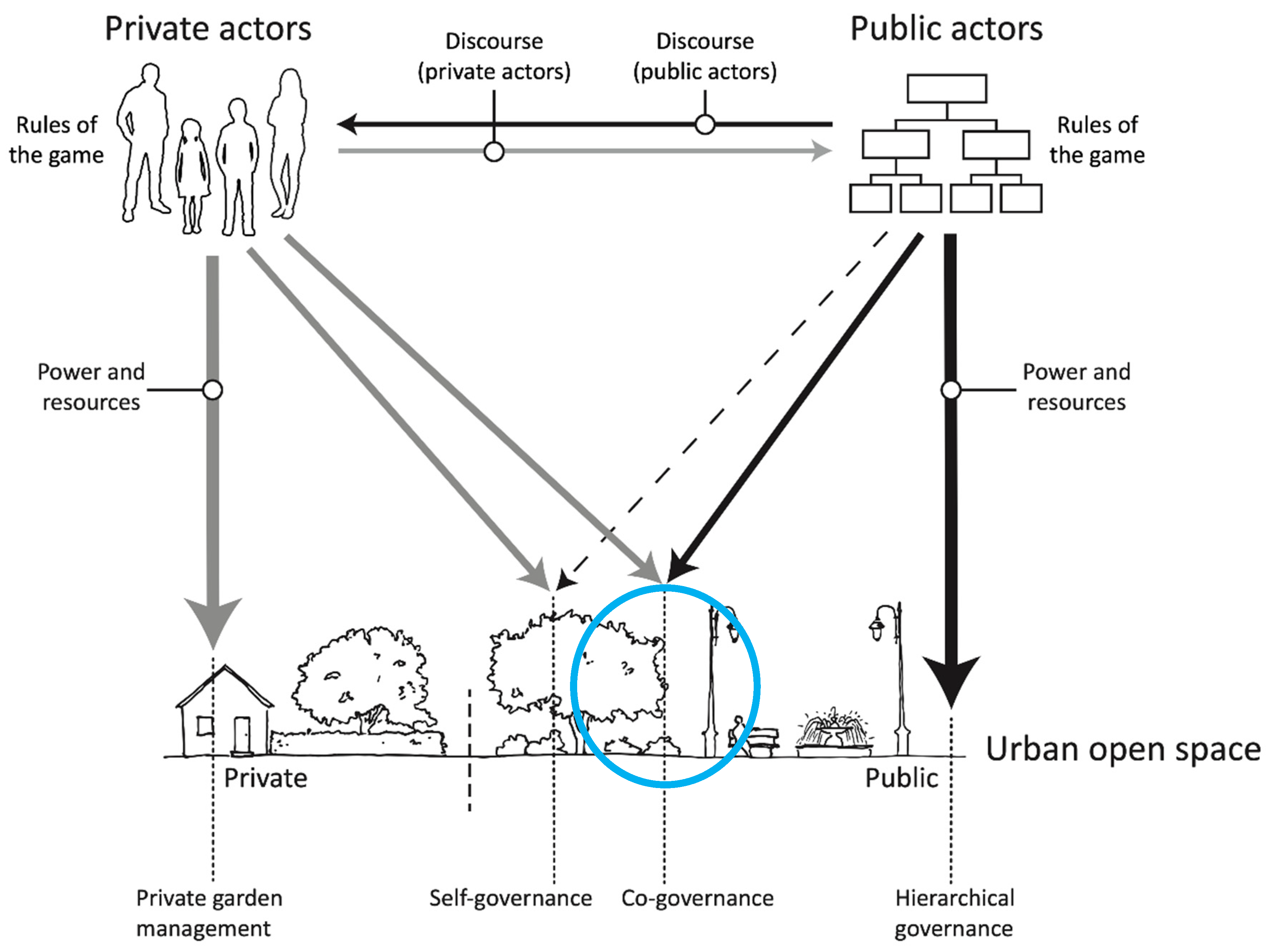
Figure 1. The combined governance and management (G&M) model of UOS. The model contains the four dimensions of a governance arrangement—actors (e.g., users, administration), power and resources (depicted through arrows from actors towards the UOS), rules of the game (depicted in boxes next to users and administration) and discourses (depicted through arrows between users and administration)—that form and amend the management process reprinted with permission from Jansson et al. [18] 2018, Märit Jansson. The object of management (UOS) can be differentiated on a governance-type axis from hierarchical to self-governance (placement of arrows). In the Norwegian case in this study, the object is placed within the blue circle.
Sustainability 15 02864 g001
Figure 2. Representation of Gimsøy Abbey. The abbey from medieval times was situated in Klosterøya East, the first monastery in Norway founded by women. Source: Laurie Vestøl.
Sustainability 15 02864 g002
Figure 3. Picture of Klosterøya as an industrial hub in approximately the 1850s. The wood and paper industry were the main industrial activities. Source: Telemark Museum.
Sustainability 15 02864 g003
Figure 4. Klosterøya UOS aerial photo, taken in 2018. Klosterøya’s UOS is the green area by the water, as part of a bigger waterfront development in Tømmerkaia, Klosterøya east, in Norway’s Skien municipality. Skien High School is the black building situated north from the green area. Source: Laurie Vestøl.
Sustainability 15 02864 g004
Figure 5. Data collection timeline in the Klosterøya UOS landscape design process. Data collection started upon initiation of the Ph.D. research in 2019 and is indicated by the red arrows. The division of the landscape process into the three phases indicated in light blue (feasibility), blue (Phase 1) and dark blue (Phase 2) was recommended by the researcher upon consultation with the design team to allow for a detailed analysis.
Sustainability 15 02864 g005
Figure 6. A landscape design produced by landscape architect Laurie Vestøl during the feasibility phase through co-creation with the design team. The figure represents the multiple green structures that the team co-designed, inspired by an ecological design and with the vision to provide learning and interaction spaces.
Sustainability 15 02864 g006
Figure 7. Representation of the feasibility phase of Klosterøya UOS landscape design, as a green model. This phase is being represented as a combined governance and management model (G&M) of UOS adapted with permission from Jansson et al. [18]. 2018, Märit Jansson, where the opportunities for sustainable solutions that the design team envisioned are depicted. Private and public actors relevant to the case are listed in the diagram boxes, where arrows towards the co-creative landscape design, indicate the role of powers (in the form of policies) and resources (in the form of financial resources).
Sustainability 15 02864 g007
Figure 8. A landscape drawing produced by landscape architect Laurie Vestøl during Phase 1 of the landscape design process through co-creation with the design team. This phase’s main focus was the wetland and how to create water circularities in the UOS.
Sustainability 15 02864 g008
Figure 9. A representation of Phase 1, the Blue Model, in the Klosterøya UOS landscape design. Phase 1 is represented as a combined governance and management (G&M) model of UOS adapted with permission from Jansson et al. [18]. 2018, Märit Jansson. The opportunities and challenges that the design team faced during this phase are depicted schematically in the diagram. The powers and resources (financial resources and environmental and planning policies) are depicted with bold letters, as they play a significant role in the model during this phase. The feedback arrow from the landscape design to the private actors is shifting the rules of the game towards implementation of the wetland and other testbeds.
Sustainability 15 02864 g009
Figure 10. The final landscape plan for Klosterøya UOS, produced by landscape architect Laurie Vestøl, through co-creation with the design team. The plan represents a more systemic approach to the UOS, creating connections (illustrated with blue dotted lines) and synergistic effects between the blue-green elements (illustrated in blue boxes) and the users.
Sustainability 15 02864 g010
Figure 11. Representation of Phase 2, the Blue-green Model in the Klosterøya UOS landscape design. Phase 2 is represented as a combined governance and management (G&M) model of UOS adapted with permission from Jansson et al. [18]. 2018, Märit Jansson. The opportunities and challenges that the design team faced during this phase are depicted schematically in the diagram. The systematic landscape design provides feedback arrows towards the private and public actors, retrofitting the powers and resources in the combined G&M model.
Sustainability 15 02864 g011
Figure 12. Representation of Klosterøya landscape design process as a combined governance and management (G&M) model of UOS adapted with permission from Jansson et al. [18]. 2018, Märit Jansson. Feedback loops—indicated by the thick, blue arrows—from the co-creative landscape design process towards the actors, policies and discourses that drive urban transformations, are retrofitting the combined governance and management (G&M) model of UOS.
Sustainability 15 02864 g012
Disclaimer/Publisher’s Note: The statements, opinions and data contained in all publications are solely those of the individual author(s) and contributor(s) and not of MDPI and/or the editor(s). MDPI and/or the editor(s) disclaim responsibility for any injury to people or property resulting from any ideas, methods, instructions or products referred to in the content.