


Proposal of a Disrupted Road Detection Method in a Tsunami Event Using Deep Learning and Spatial Data


Abstract
:1. Introduction
2. Materials and Methods
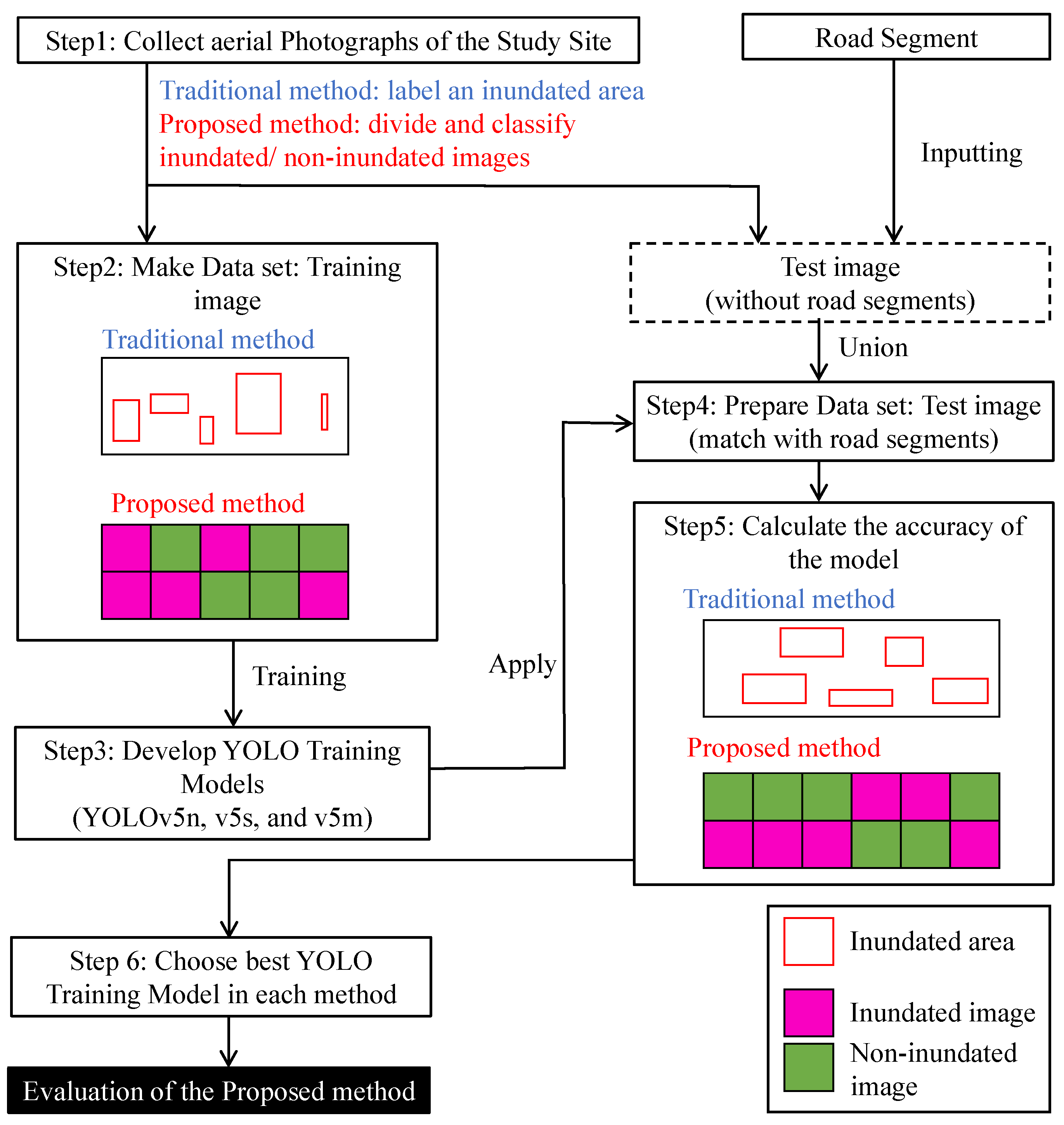
2.1. Method Flowchart
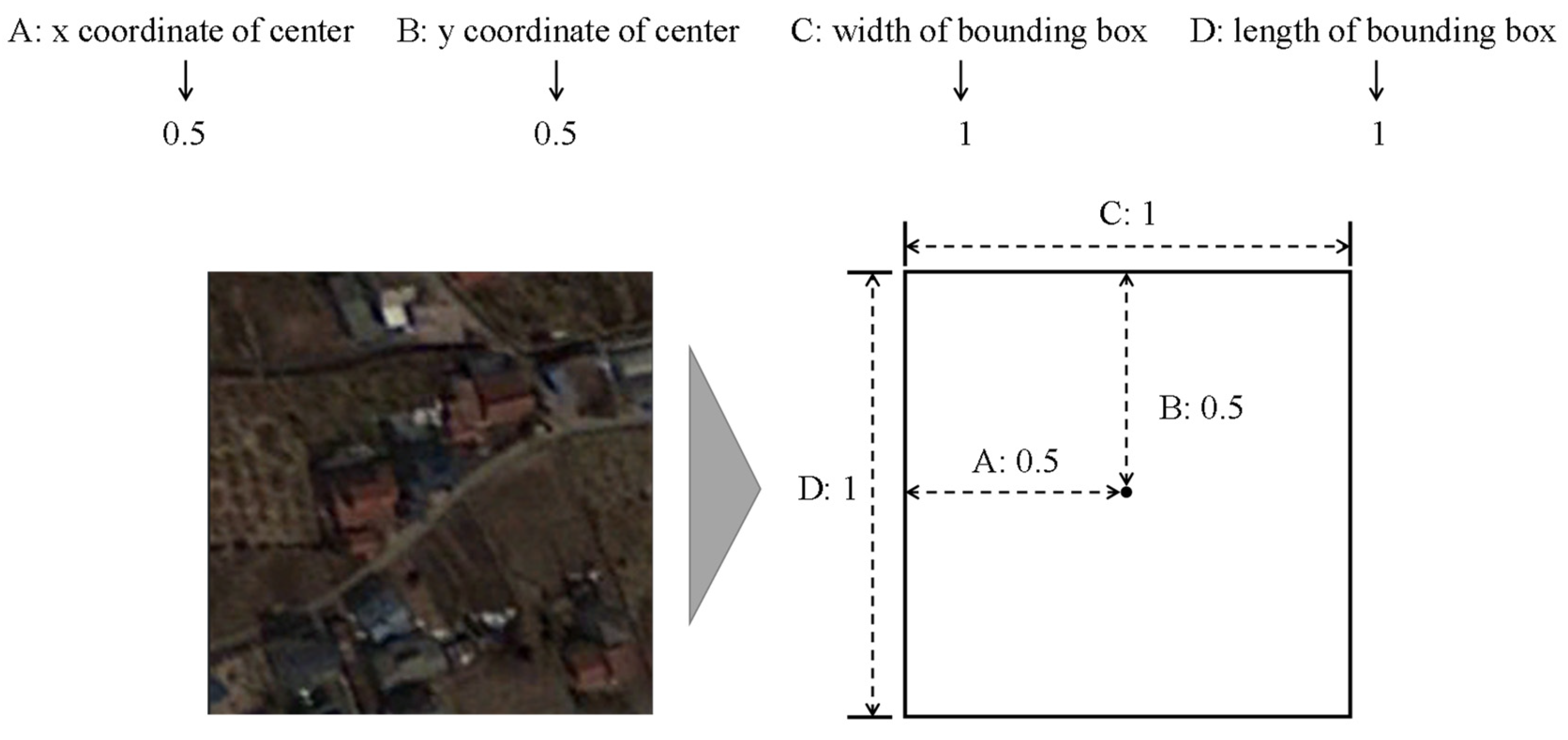
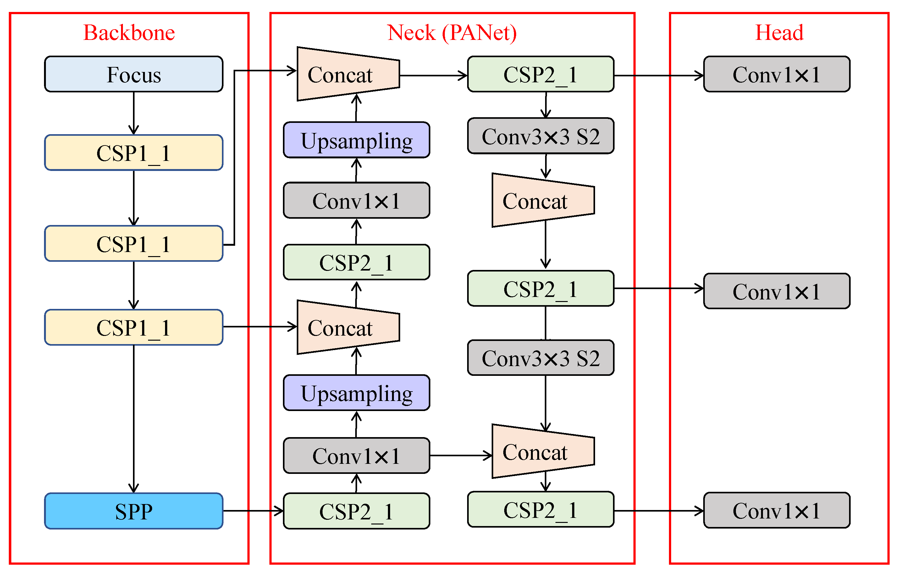
2.2. Outline of YOLOv5 Model
2.3. Outline of Google Colaboratory
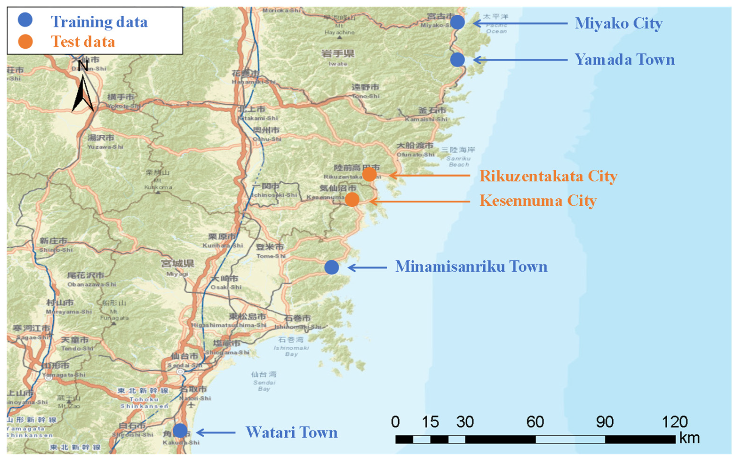
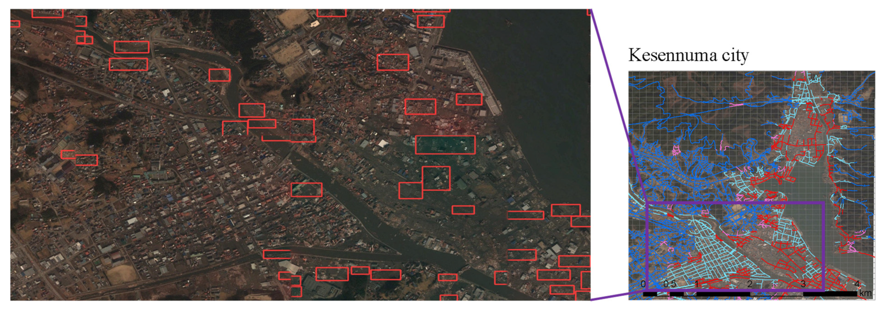
2.4. Data
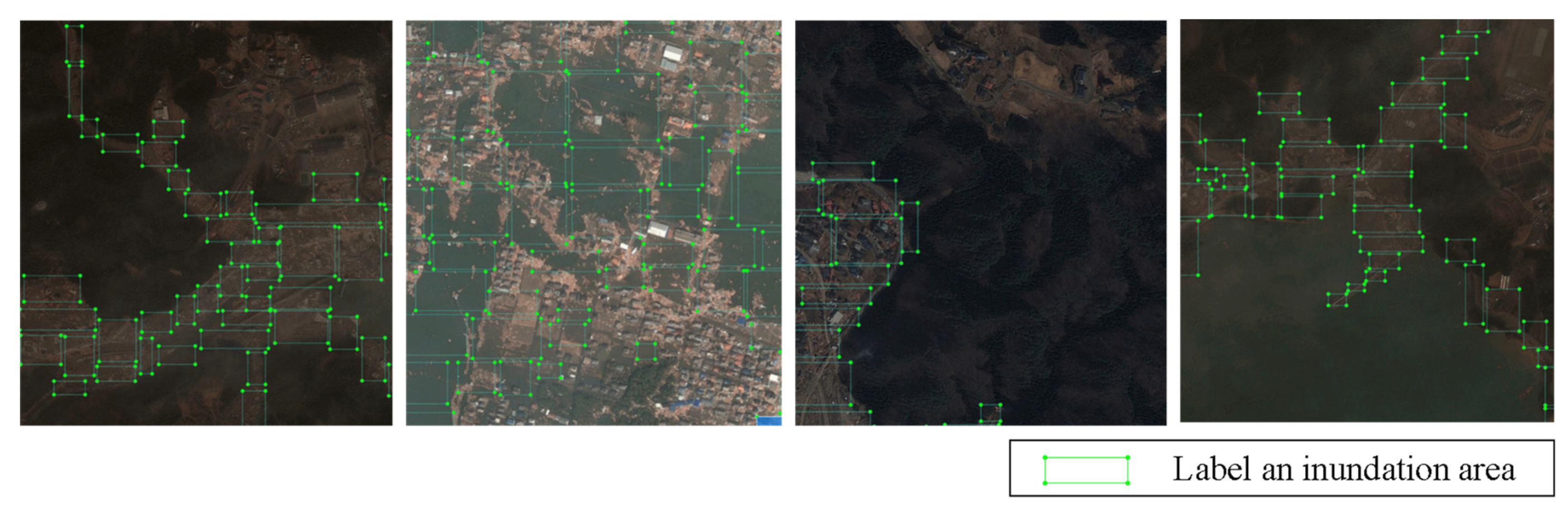
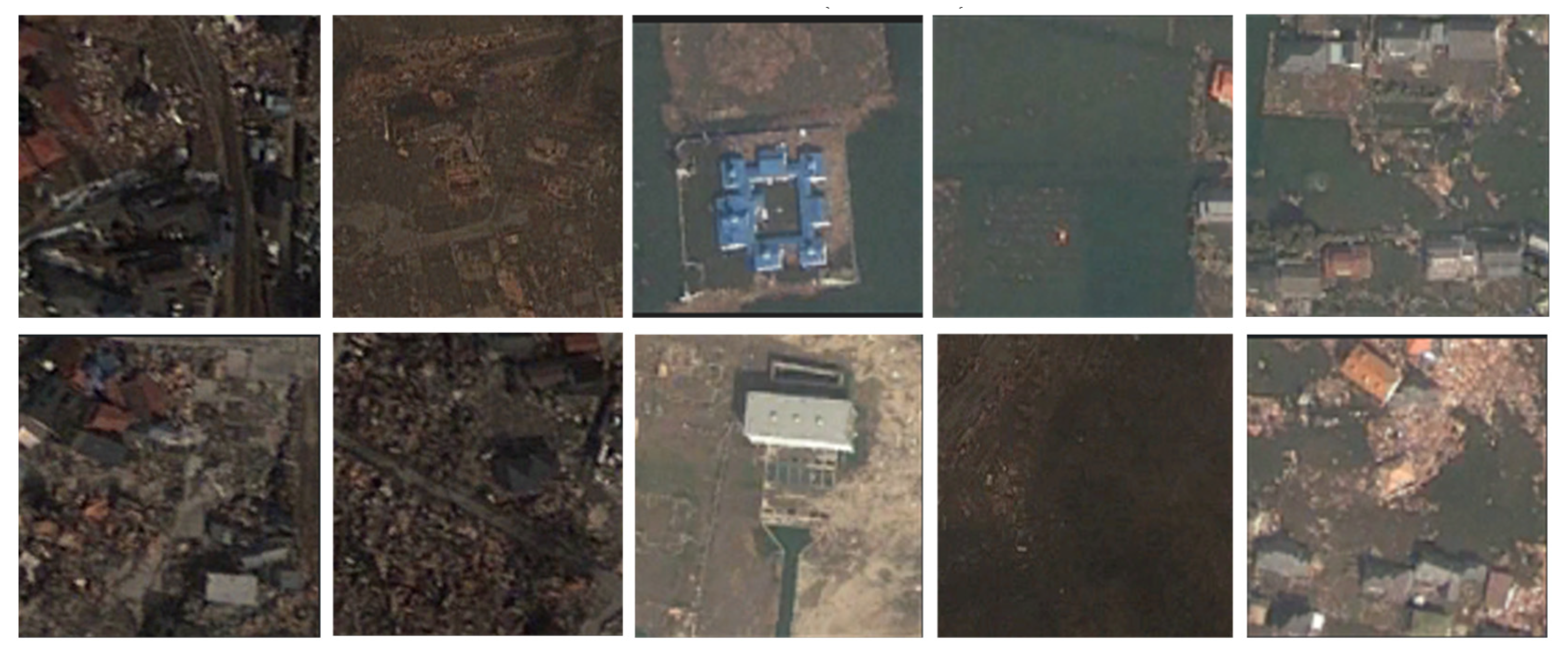
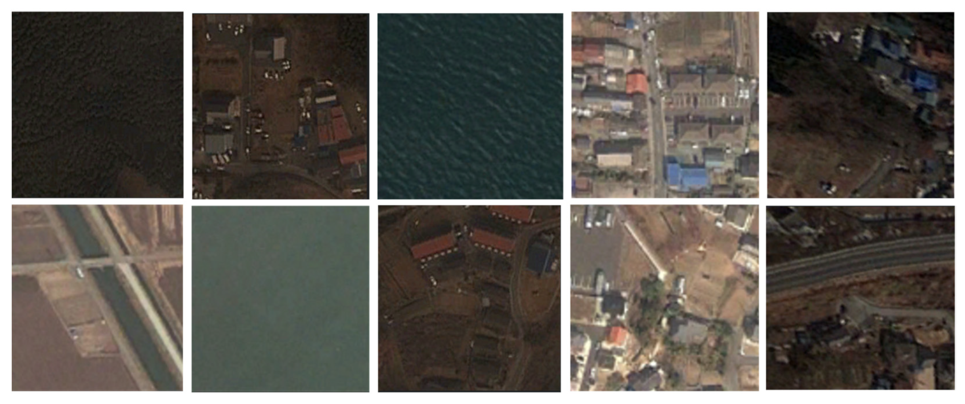
2.4.1. Training and Test Images
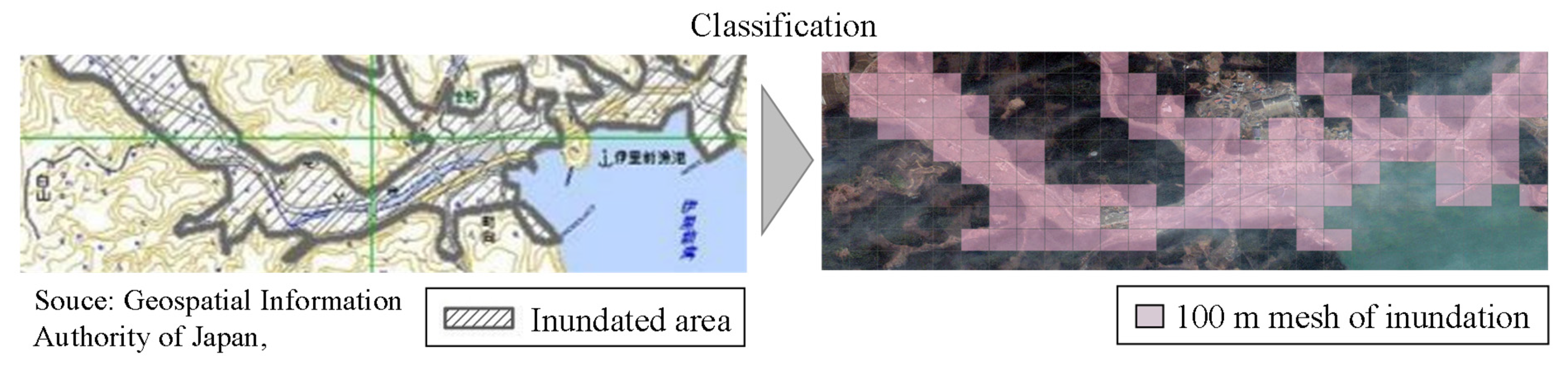
2.4.2. Road Segment
2.5. Evaluation Indicators
3. Results and Discussion
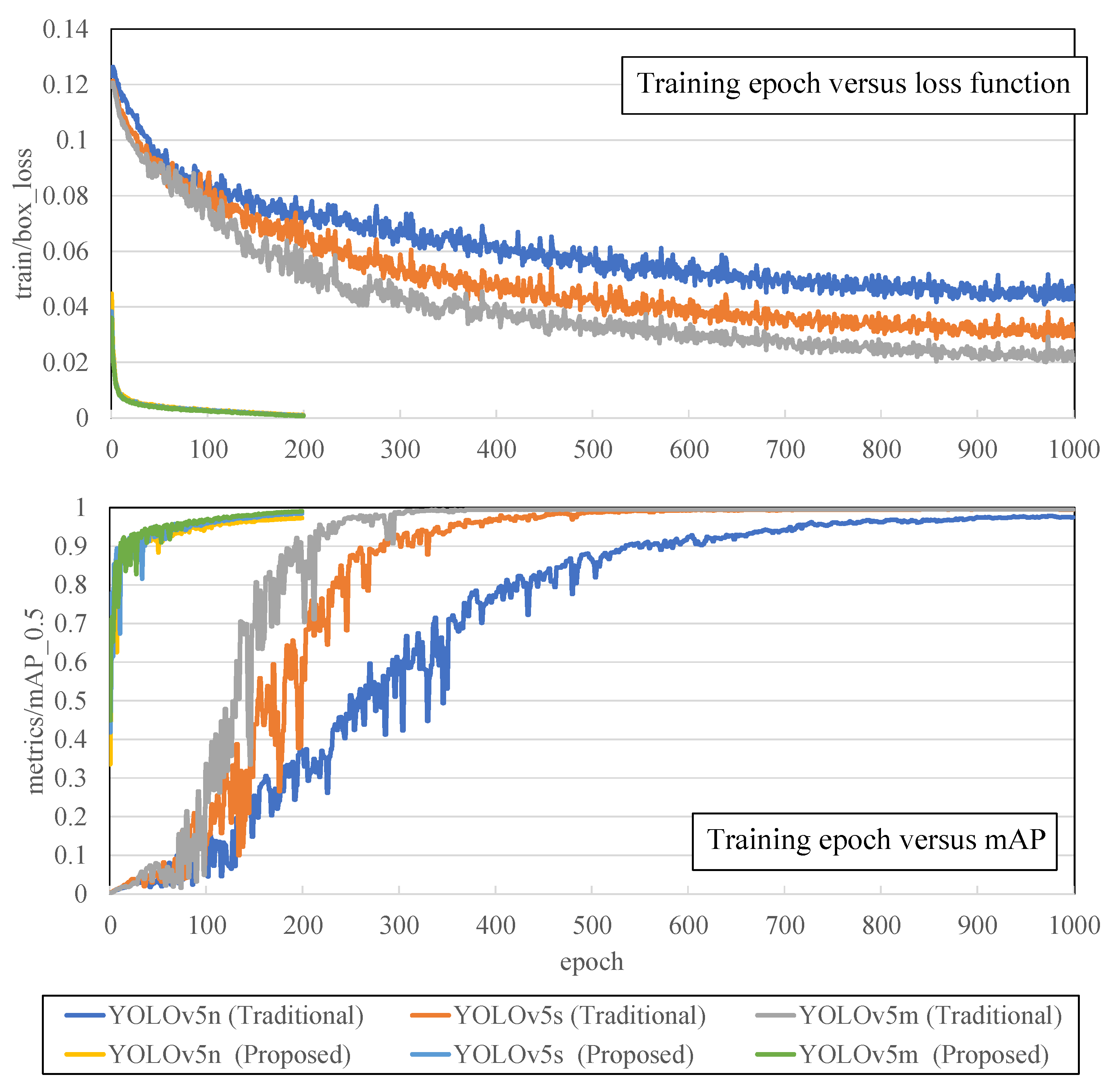
3.1. Training Result
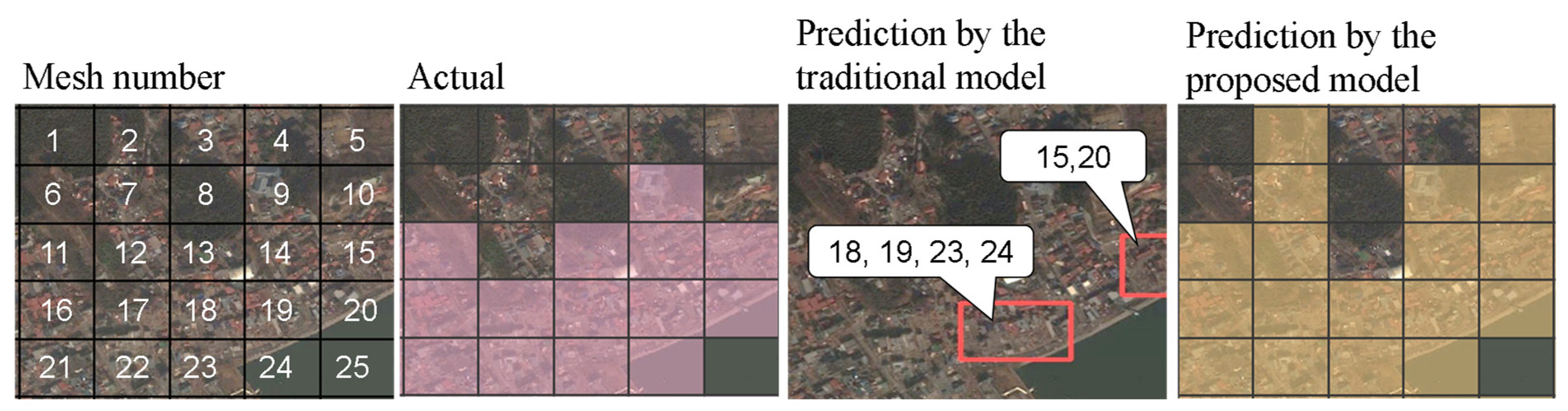
3.2. Comparative Analysis of Models
3.3. Accuracy Verification Focusing on the Number of Samples
4. Conclusions
Funding
Institutional Review Board Statement
Informed Consent Statement
Data Availability Statement
Conflicts of Interest
References
- Disaster Management, Cabinet Office, White Paper on Disaster Management. 2011. Available online: https://www.bousai.go.jp/kaigirep/hakusho/h23/bousai2011/html/honbun/index.htm (accessed on 6 January 2023).
- Wang, Y.; Tsushima, H.; Satake, K.; Navarrete, P. Review on recent progress in near-field tsunami forecasting using offshore tsunami measurements: Source inversion and data assimilation. Pure Appl. Geophys. 2021, 178, 5109–5128. [Google Scholar] [CrossRef]
- Wang, Y.; Imai, K.; Kusumoto, S.; Takahashi, N. Tsunami early warning of the Hunga volcanic eruption using an ocean floor observation network off the Japanese Islands. Seismol. Res. Lett. 2022. [Google Scholar] [CrossRef]
- White paper on Ministry of Land, Infrastructure, Transport and Tourism in Japan. Available online: https://www.mlit.go.jp/hakusyo/mlit/r01/hakusho/r02/html/n1222000.html (accessed on 6 January 2023).
- Eguchi, R.T.; Huyck, C.K.; Ghosh, S.; Adams, B.J.; McMillan, A. Utilizing new technologies in managing hazards and disasters. Geospat. Tech. Urban Hazard Disaster Anal. 2009, 295–323. [Google Scholar] [CrossRef]
- Nex, F.; Duarte, D.; Steenbeek, A.; Kerle, N. Towards real-time building damage mapping with low-cost UAV solutions. Remote Sens. 2019, 11, 287. [Google Scholar] [CrossRef]
- Raffini, F.; Bertorelle, G.; Biello, R.; D’Urso, G.; Russo, D.; Bosso, L. From nucleotides to satellite imagery: Approaches to identify and manage the invasive pathogen Xylella fastidiosa and its insect vectors in Europe. Sustainability 2020, 12, 4508. [Google Scholar] [CrossRef]
- Gong, L.; Li, Q.; Zhang, J. Earthquake building damage detection with object-oriented change detection. IEEE Int. Geosci. Remote Sens. Symp-IGARSS 2013, 2013, 3674–3677. [Google Scholar] [CrossRef]
- Dong, Z.; Zhang, M.; Li, L.; Liu, Q.; Wen, Q.; Wang, W.; Ji, W. A multiscale building detection method based on boundary preservation for remote sensing images: Taking the Yangbi M6. 4 earthquake as an example. Nat Hazards Res. 2022, 2, 121–131. [Google Scholar] [CrossRef]
- Ge, P.; Gokon, H.; Meguro, K. Building damage assessment using intensity SAR data with different incidence angles and longtime interval. J. Disaster Res. 2019, 14, 456–465. [Google Scholar] [CrossRef]
- Hu, Q.; Zhou, Y.; Wang, S.; Wang, F.; Wang, H. Improving the accuracy of landslide detection in “off-site” area by machine learning model portability comparison: A case study of Jiuzhaigou earthquake, China. Remote Sens. 2019, 11, 2530. [Google Scholar] [CrossRef]
- Weicong, D.; Longxu, J.; Guoning, L.; Zhiqiang, Z. Real-time airplane detection algorithm in remote-sensing images based on improved YOLOv3. Opto. Electron. Eng. 2018, 45, 180350–180351. [Google Scholar]
- Demir, I.; Koperski, K.; Lindenbaum, D.; Pang, G.; Huang, J.; Basu, S.; Hughes, F.; Tuia, D.; Raskar, R. Deepglobe 2018: A challenge to parse the earth through satellite images. In Proceedings of the IEEE Conference on Computer Vision and Pattern Recognition Workshops, Salt Lake City, UT, USA, 18–22 June 2018; pp. 172–17209. [Google Scholar] [CrossRef] [Green Version]
- Miura, H.; Aridome, T.; Matsuoka, M. Deep learning-based identification of collapsed, non-collapsed and blue tarp-covered buildings from post-disaster aerial images. Remote Sens. 2020, 12, 1924. [Google Scholar] [CrossRef]
- Ma, H.; Liu, Y.; Ren, Y.; Wang, D.; Yu, L.; Yu, J. Improved CNN classification method for groups of buildings damaged by earthquake, based on high resolution remote sensing images. Remote Sens. 2020, 12, 260. [Google Scholar] [CrossRef]
- Tilon, S.; Nex, F.; Kerle, N.; Vosselman, G. Post-disaster building damage detection from earth observation imagery using unsupervised and transferable anomaly detecting generative adversarial networks. Remote Sens. 2020, 12, 4193. [Google Scholar] [CrossRef]
- Pi, Y.; Nath, N.D.; Behzadan, A.H. Convolutional neural networks for object detection in aerial imagery for disaster response and recovery. Adv. Eng. Inform. 2020, 43, 101009. [Google Scholar] [CrossRef]
- Liu, C.; Sui, H.; Wang, J.; Ni, Z.; Ge, L. Real-time ground-level building damage detection based on lightweight and accurate YOLOv5 using terrestrial images. Remote Sens. 2022, 14, 2763. [Google Scholar] [CrossRef]
- Nex, F.; Duarte, D.; Tonolo, F.G.; Kerle, N. Structural building damage detection with deep learning: Assessment of a state-of-the-art CNN in operational conditions. Remote Sens. 2019, 11, 2765. [Google Scholar] [CrossRef]
- Geospatial Information Authority of Japan, Tsunami Inundation Map (Scale 1:25,000). Available online: https://www.gsi.go.jp/kikaku/kikaku40014.html (accessed on 6 January 2023).
- Pratheesh Shivaprasad, A. Comprehensive Guide to Object Detection Using YOLO Framework? Part I. Available online: https://towardsdatascience.com/object-detection-part1-4dbe5147ad0a (accessed on 6 January 2023).
- Google Colab. Google. Available online: https://colab.research.google.com/notebooks/welcome.ipynb?hl=ja (accessed on 6 January 2023).
- Redmon, J.; Divvala, S.; Girshick, R.; Farhadi, A. You only look once: Unified, real-time object detection. In Proceedings of the IEEE Conference on Computer Vision and Pattern Recognition, Las Vegas, NV, USA, 26 June–1 July 2016; pp. 779–788. [Google Scholar] [CrossRef]
- YOLOv5 Download Site. Available online: https://github.com/ultralytics/yolov5 (accessed on 6 January 2023).
- What Is YOLOv5? A Guide for Beginners. Available online: https://blog.roboflow.com/yolov5-improvements-and-evaluation/ (accessed on 29 January 2023).
- Ge, Z.; Liu, S.; Wang, F.; Li, Z.; Sun, J. Yolox: Exceeding Yolo Series in 2021, Computer Vision and Pattern Recognition. arXiv 2021, arXiv:2107.08430. [Google Scholar]
- SeekFire Overview of Model Structure about YOLOv5. Available online: https://github.com/ultralytics/yolov5/issues/280 (accessed on 6 January 2023).
- Hu, D.; Zhang, Y.; Xufeng, L.; Zhang, X. Detection of material on a tray in automatic assembly line based on convolutional neural network. IET Image. Process. 2021, 15, 3400–3409. [Google Scholar] [CrossRef]
- Jocher, G. Train Custom Data. Available online: https://github.com/ultralytics/yolov5/wiki/Train-Custom-Data (accessed on 6 January 2023).
- Google Colaboratory: Frequently Asked Questions. Google. Available online: https://research.google.com/colaboratory/faq.html (accessed on 6 January 2023).
- Carneiro, T.; Medeiros Da Nobrega, R.V.; Nepomuceno, T.; Bian, G.; De Albuquerque, V.H.C.; Filho, P.P.R. Performance analysis of Google Colaboratory as a tool for accelerating deep learning applications. IEEE Access 2018, 6, 61677–61685. [Google Scholar] [CrossRef]
- Overview of the 2019 White Paper on Fire Service, Fire and Disaster Management Agency. Available online: https://www.fdma.go.jp/publication/hakusho/h26/cat/740.html (accessed on 6 January 2023).
- Google Earth Download Site. Available online: https://www.google.co.jp/intl/ja/earth/ (accessed on 6 January 2023).
- Conservation GIS-Consortium Japan. Available online: http://cgisj.jp (accessed on 6 January 2023).
- Jiang, B.; Luo, R.; Mao, J.; Xiao, T.; Jiang, Y. Acquisition of localization confidence for accurate object detection. In Proceedings of the European Conference on Computer Vision (ECCV), Munich, Germany, 8–14 September 2018; pp. 816–832. [Google Scholar] [CrossRef] [Green Version]
- Karacı, A. VGGCOV19-NET: Automatic detection of COVID-19 cases from X-ray images using modified VGG19 CNN architecture and YOLO algorithm. Neural Comput. Appl. 2022, 34, 8253–8274. [Google Scholar] [CrossRef]
- Li, Z.; Namiki, A.; Suzuki, S.; Wang, Q.; Zhang, T.; Wang, W. Application of low-altitude UAV remote sensing image object detection based on improved YOLOv5. Appl. Sci. 2022, 12, 8314. [Google Scholar] [CrossRef]


| Category | Muricipality | Humam Damage | Housing Damage | Non-Housing Damage | ||||
|---|---|---|---|---|---|---|---|---|
| Death | Missing | Injured | Completey Destoyed | Partially Destoyed | Public Building | Others | ||
| Training data | Miyako City | 473 | 94 | 33 | 2767 | 1331 | 70 | |
| Yamada Town | 683 | 148 | unknown | 2762 | 405 | 65 | unknown | |
| Minamisanriku Town | 620 | 216 | unknown | 3143 | 178 | 14 | 220 | |
| Test data | Rikzentaka City | 1599 | 207 | unknown | 3805 | 240 | 61 | unknown |
| Kesermuma City | 1198 | 230 | 8483 | 2571 | 9605 | |||
| Study Area | Number of Inundated Images | Number of Non-Imundated Images | Number of Total: Images | |||
|---|---|---|---|---|---|---|
| Training images | Yamada Town | 255 | (32%) | 551 | (68%) | 806 |
| Miyako City | 153 | 35%) | 284 | (65%) | 437 | |
| Minamisanriku Town | 114 | (39%) | 176 | (61%) | 290 | |
| Watari Town | 897 | (57%) | 678 | (43%) | 1575 | |
| Test images | Rikuzentakata City | 958 | (34%) | 1870 | (66%) | 2828 |
| Kesennuma City | 494 | (27%) | 1366 | (73%) | 1860 | |
| Method | Study Area | Model | TP | TN | FP | FN | Precision | Recall | Specificity | F1 Score | Training Time (h) |
|---|---|---|---|---|---|---|---|---|---|---|---|
| Traditional method | Rikuzentakata City | Yolov5n | 517 | 1653 | 217 | 441 | 70% | 54% | 88% | 61% | 0.300 |
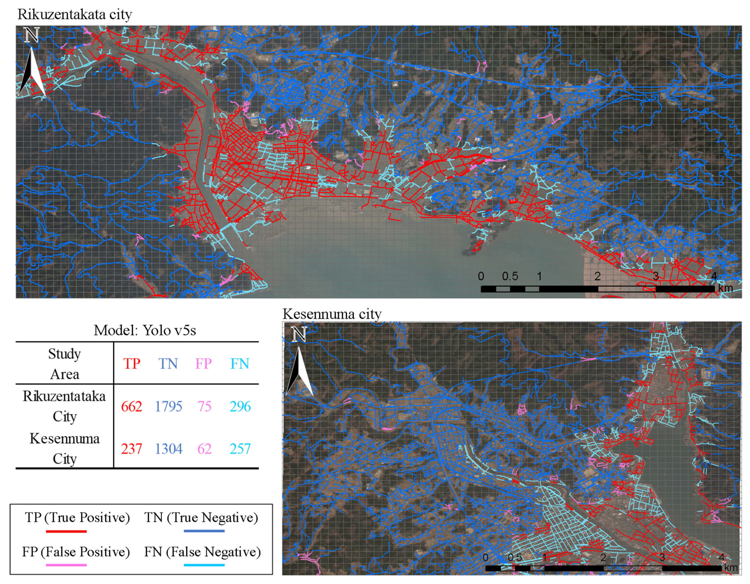
| Yolov5s | 662 | 1795 | 75 | 296 | 90% | 69% | 96% | 78% | 0.350 | ||
| Yolov5m | 429 | 1821 | 49 | 529 | 90% | 45% | 97% | 60% | 0.633 | ||
| Kesernnuma City | Yolov5n | 270 | 1214 | 152 | 224 | 64% | 55% | 89% | 59% | 0.300 | |
| Yolov5s | 237 | 1304 | 62 | 257 | 79% | 48% | 95% | 60% | 0.350 | ||
| Yolov5m | 236 | 1299 | 67 | 258 | 78% | 48% | 95% | 59% | 0.633 | ||
| Proposed method | RikuzentakataCity | Yolov5n | 817 | 1603 | 267 | 141 | 75% | 85% | 86% | 80% | 2.867 |
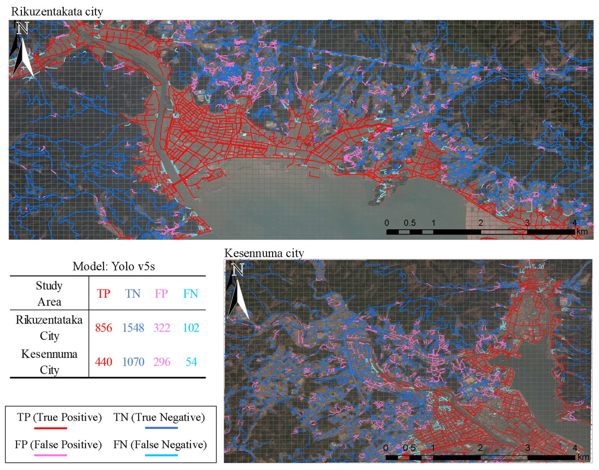
| Yolov5s | 856 | 1548 | 322 | 102 | 73% | 89% | 83% | 80% | 3.867 | ||
| Yolov5m | 809 | 1681 | 189 | 149 | 81% | 84% | 90% | 83% | 8.800 | ||
| Kesennnuma City | Yolov5n | 441 | 966 | 400 | 53 | 52% | 89% | 71% | 66% | 2.867 | |
| Yolov5s | 440 | 1070 | 296 | 54 | 60% | 89% | 78% | 72% | 3.867 | ||
| Yolov5m | 456 | 928 | 438 | 38 | 51% | 92% | 68% | 66% | 8.800 |
| Study Area | Percentage of Sample | TP | TN | FP | FN | Precision | Recall | Specificity | F1 Score | Training Time (h) |
|---|---|---|---|---|---|---|---|---|---|---|
| Rikuzentakata City | 25% | 934 | 424 | 1446 | 24 | 39% | 97% | 23% | 56% | 0.883 |
| 50% | 898 | 1173 | 697 | 60 | 56% | 94% | 63% | 70% | 1.733 | |
| 75% | 898 | 1429 | 441 | 60 | 67% | 94% | 76% | 78% | 3.467 | |
| 100% | 856 | 1548 | 322 | 102 | 73% | 89% | 83% | 80% | 3.867 | |
| Kesennuma City | 25% | 467 | 257 | 1109 | 27 | 30% | 95% | 19% | 45% | 0.883 |
| 50% | 486 | 623 | 743 | 8 | 40% | 98% | 46% | 56% | 1.733 | |
| 75% | 450 | 950 | 416 | 44 | 52% | 91% | 70% | 66% | 3.467 | |
| 100% | 440 | 1070 | 296 | 54 | 60% | 89% | 78% | 72% | 3.867 |
Disclaimer/Publisher’s Note: The statements, opinions and data contained in all publications are solely those of the individual author(s) and contributor(s) and not of MDPI and/or the editor(s). MDPI and/or the editor(s) disclaim responsibility for any injury to people or property resulting from any ideas, methods, instructions or products referred to in the content. |
© 2023 by the author. Licensee MDPI, Basel, Switzerland. This article is an open access article distributed under the terms and conditions of the Creative Commons Attribution (CC BY) license (https://creativecommons.org/licenses/by/4.0/).
Share and Cite
Sakamoto, J. Proposal of a Disrupted Road Detection Method in a Tsunami Event Using Deep Learning and Spatial Data. Sustainability 2023, 15, 2936. https://doi.org/10.3390/su15042936
Sakamoto J. Proposal of a Disrupted Road Detection Method in a Tsunami Event Using Deep Learning and Spatial Data. Sustainability. 2023; 15(4):2936. https://doi.org/10.3390/su15042936
Chicago/Turabian StyleSakamoto, Jun. 2023. "Proposal of a Disrupted Road Detection Method in a Tsunami Event Using Deep Learning and Spatial Data" Sustainability 15, no. 4: 2936. https://doi.org/10.3390/su15042936