
The Impact of Spontaneous and Induced Restoration on the Hydromorphological Conditions and Macrophytes, Example of Flinta River

Abstract
:1. Introduction
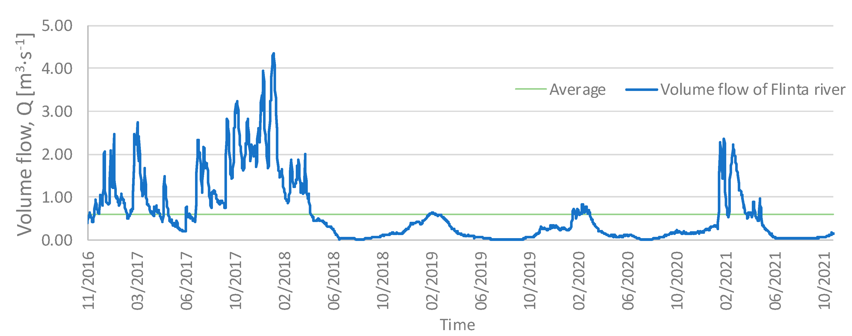
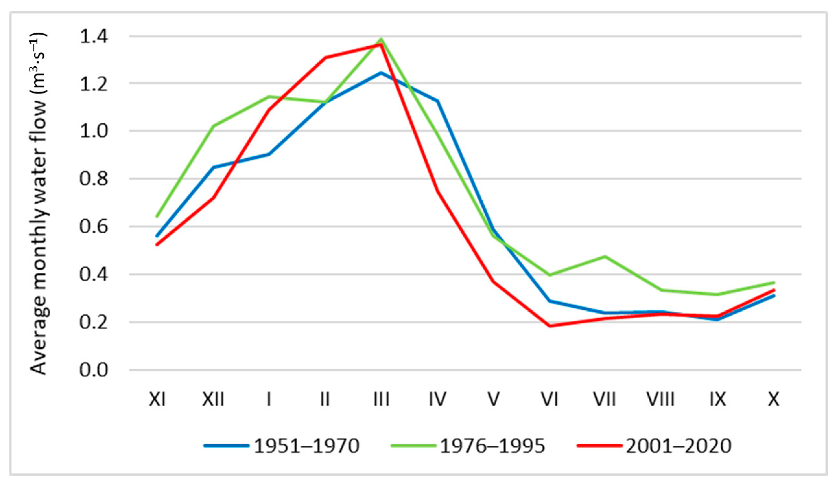
2. Study Area
3. Materials and Methods
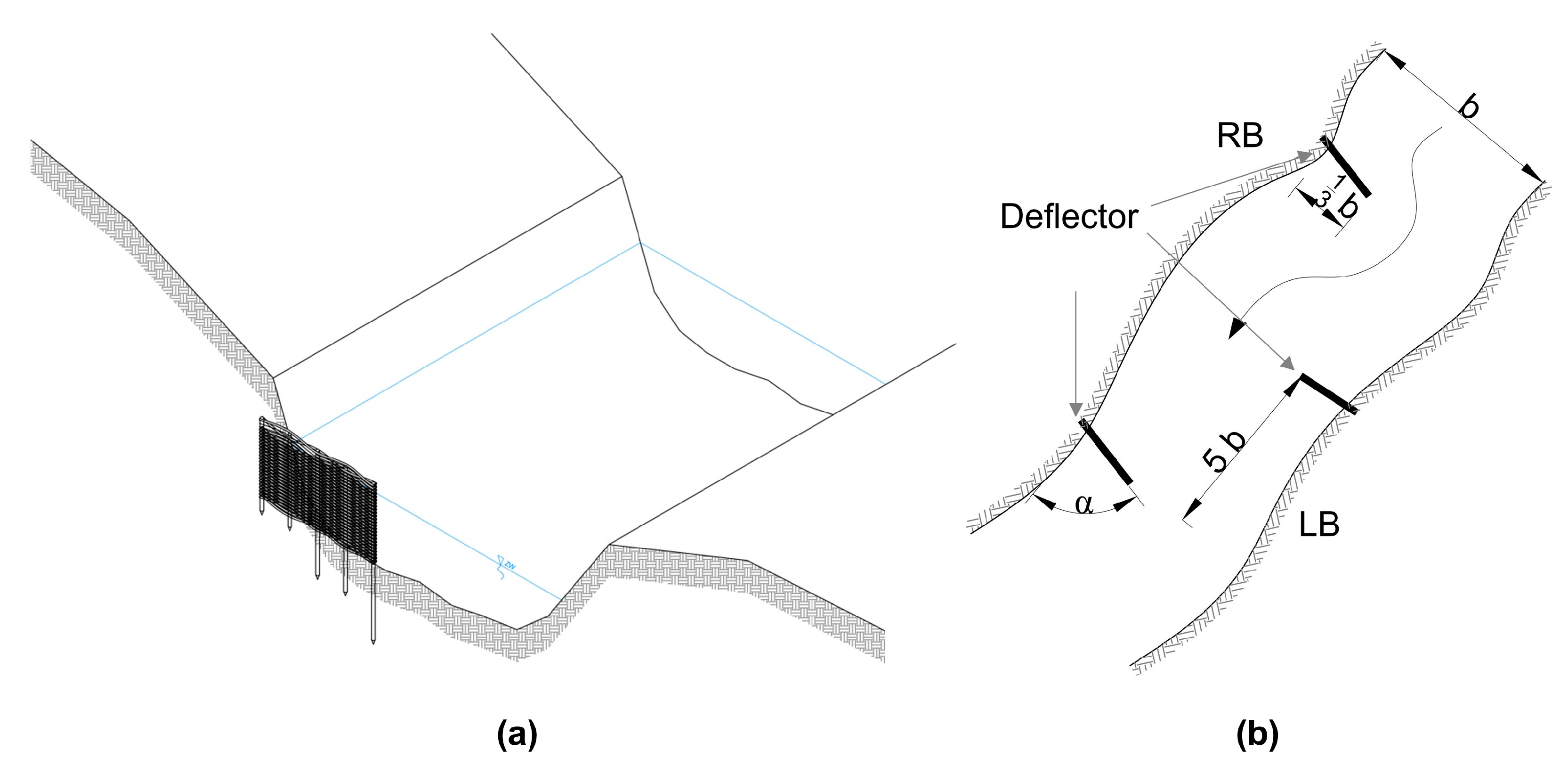
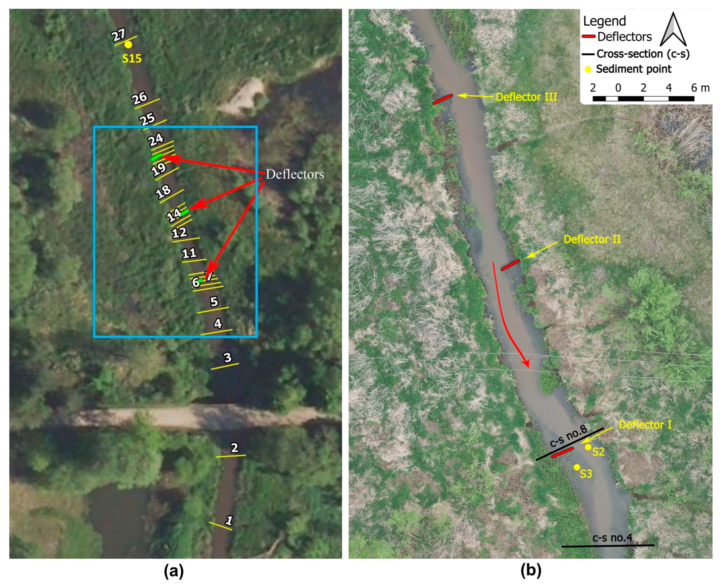
3.1. Construction of Deflectors
3.2. Geodetic Surveying
3.3. Changes in Sediment Size
3.4. Hydromorphological Surveys
3.5. Macrophyte Surveys
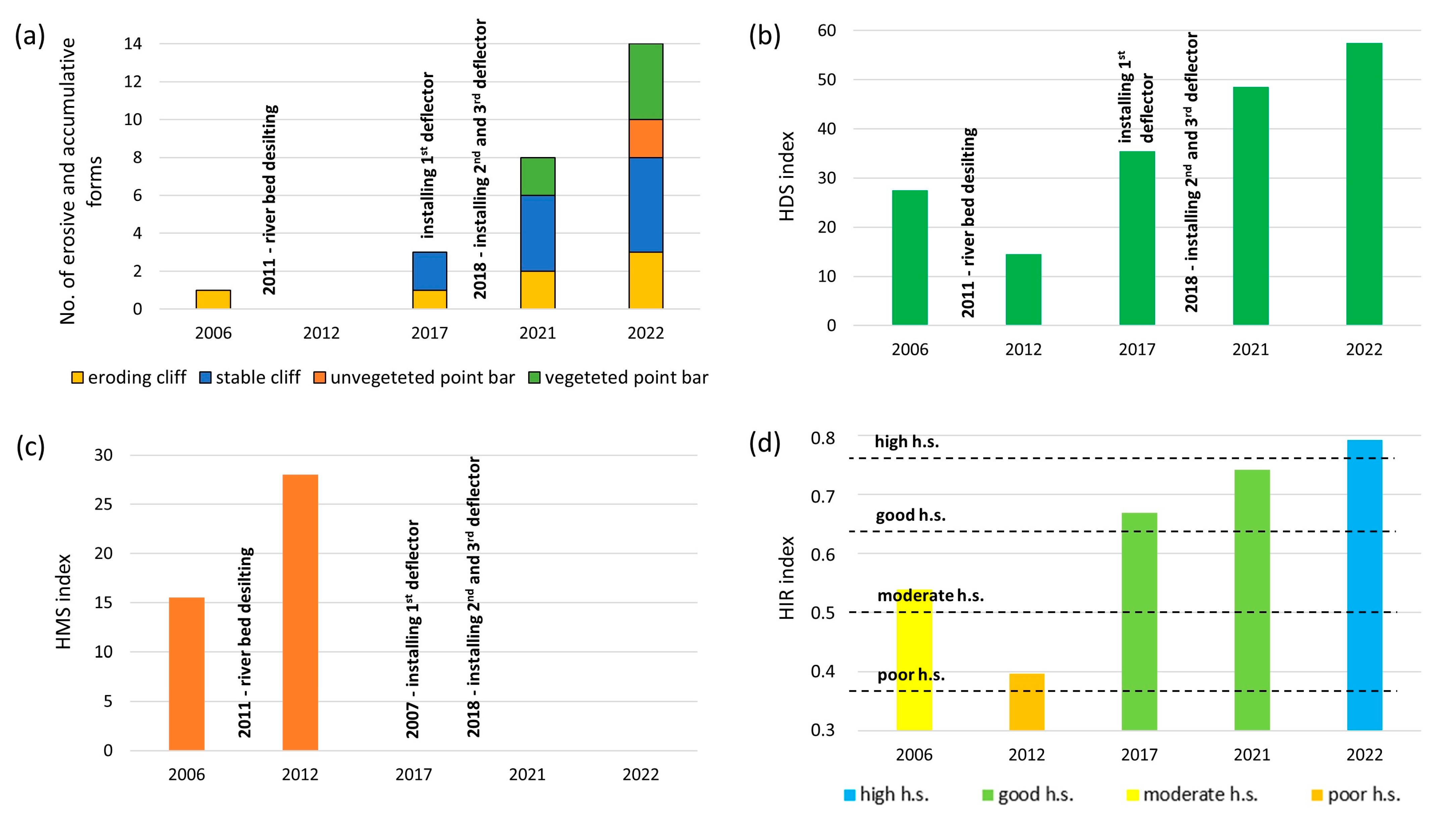
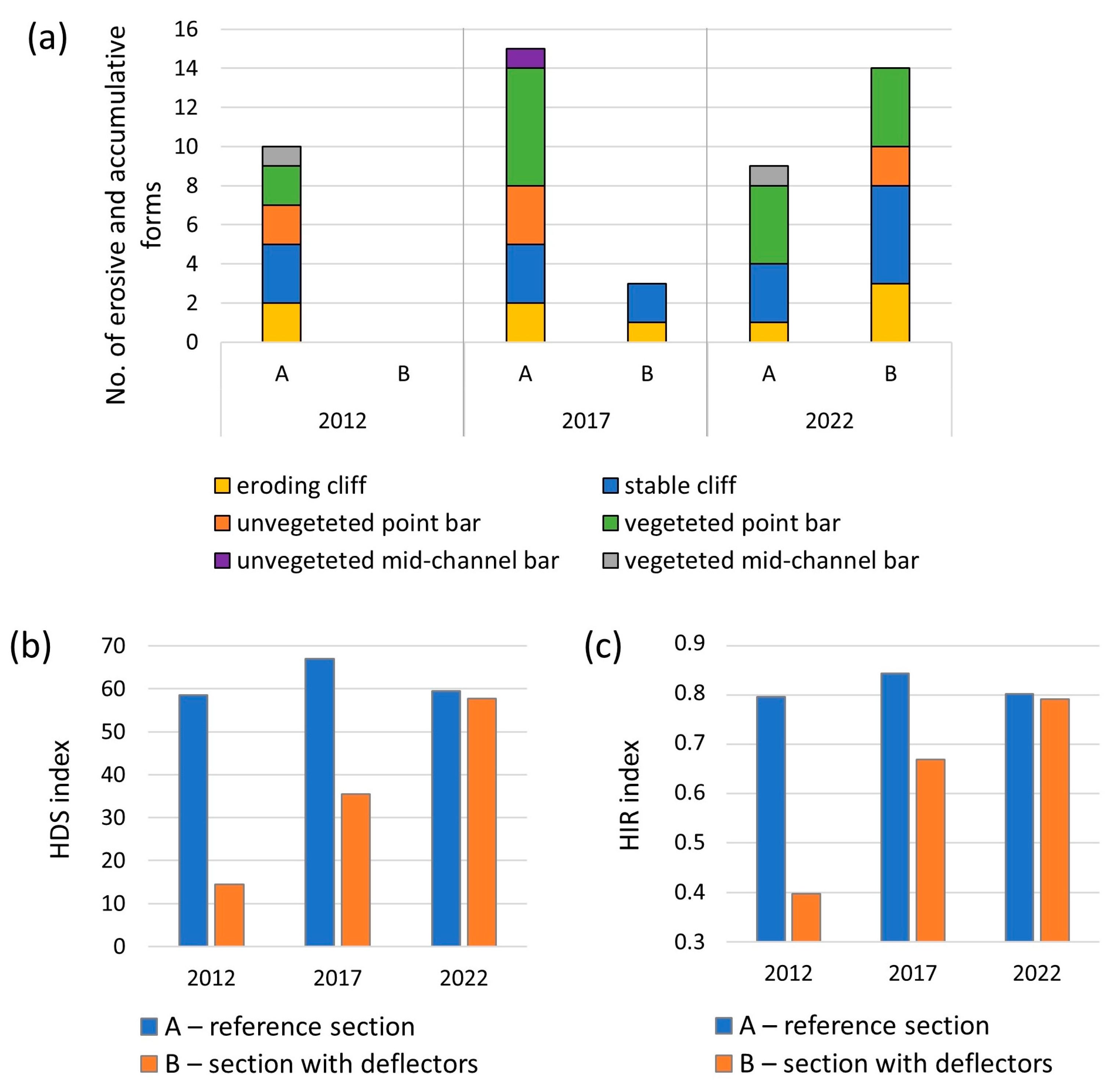
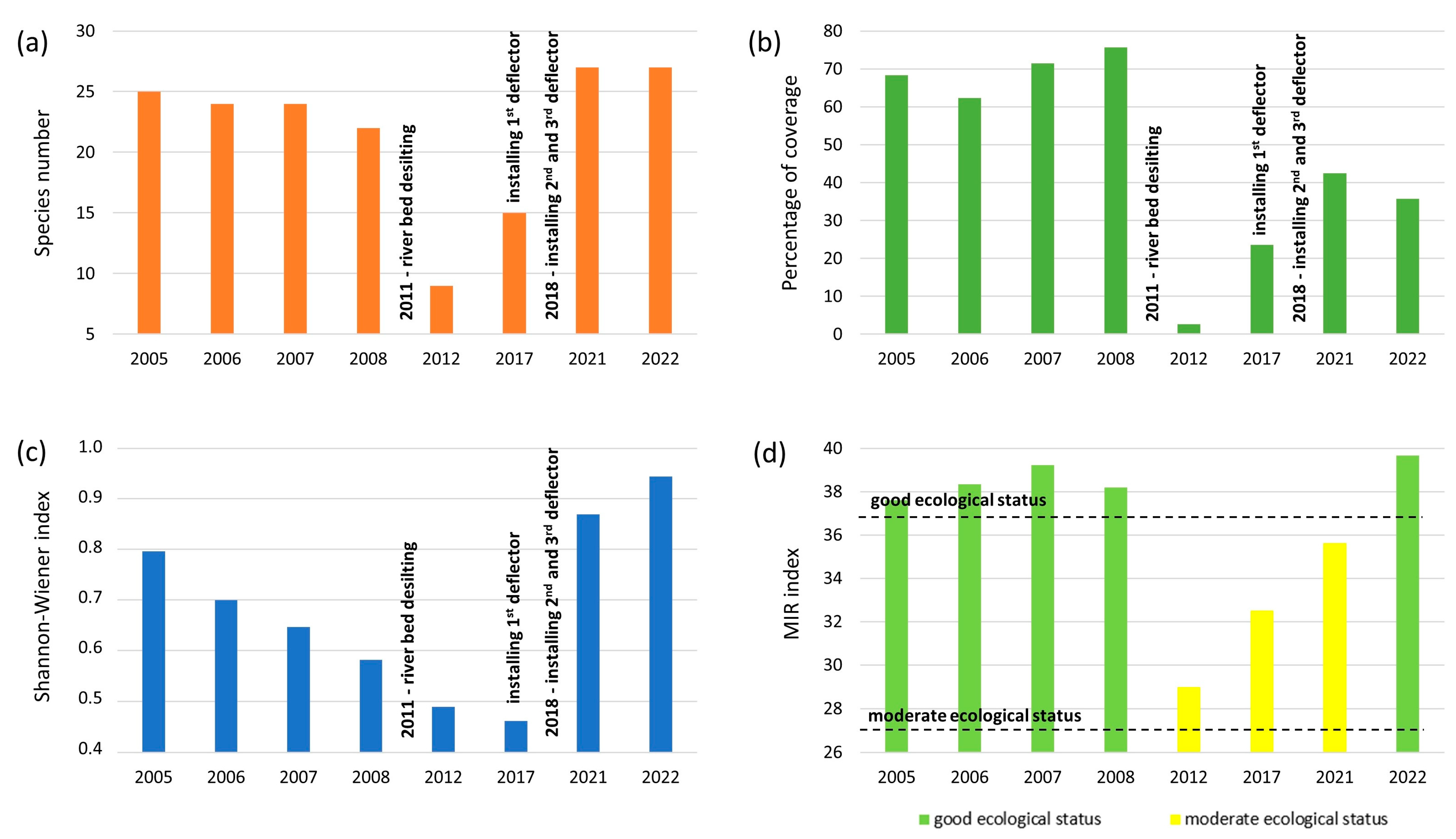
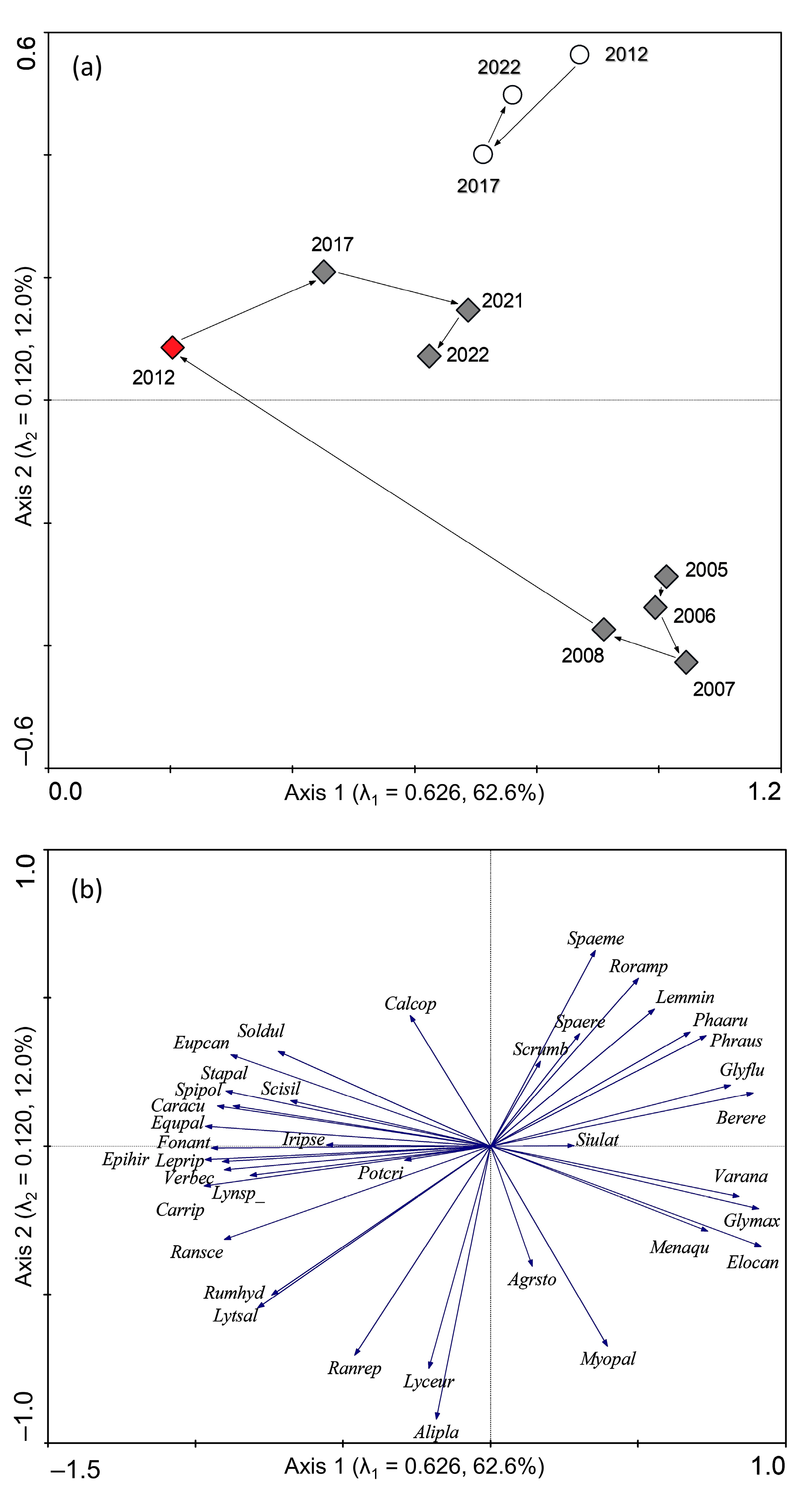
4. Results
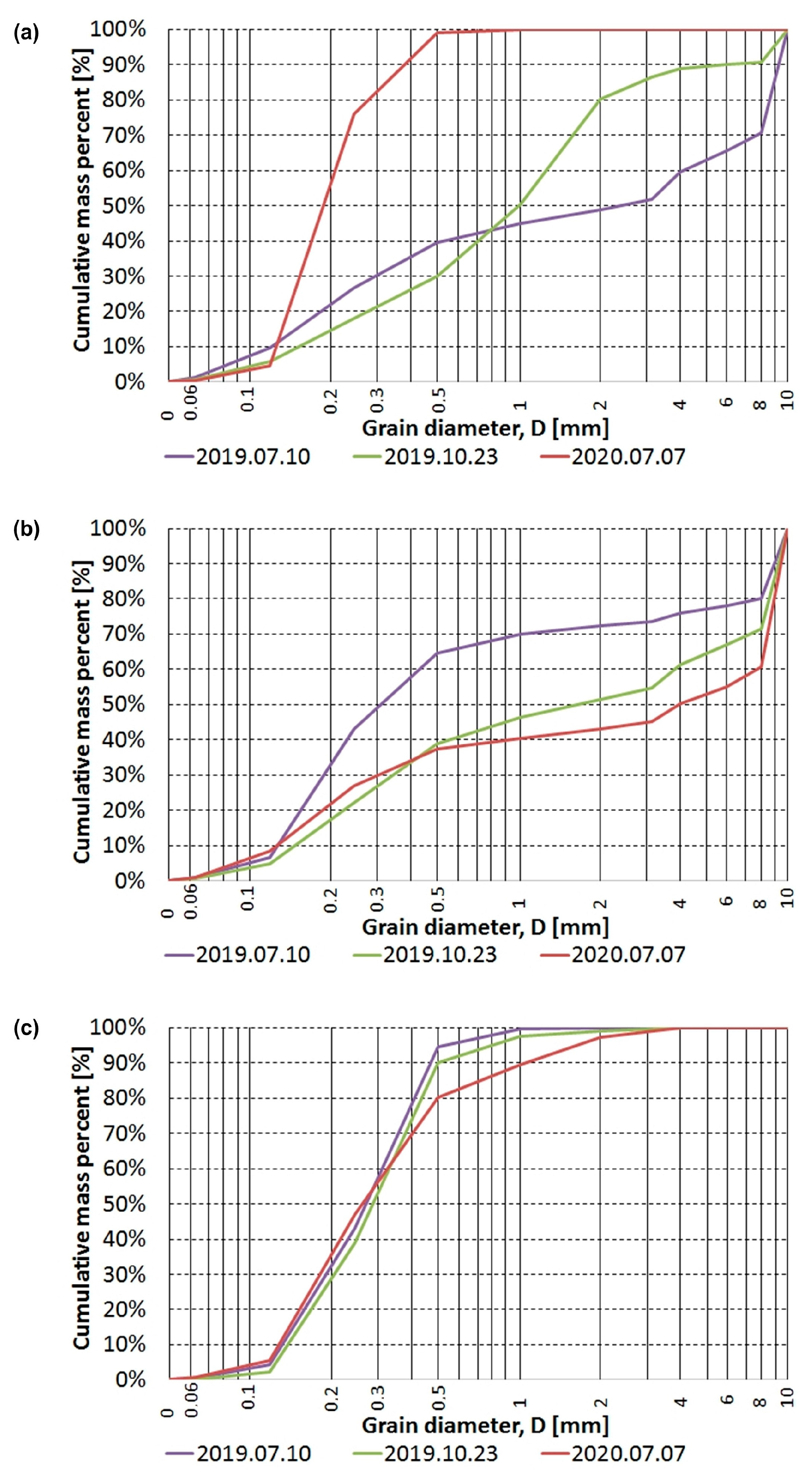
4.1. Changes in Sediment Size
4.2. Hydromorphological Surveys
4.3. Macrophyte Surveys
5. Discussion
6. Conclusions
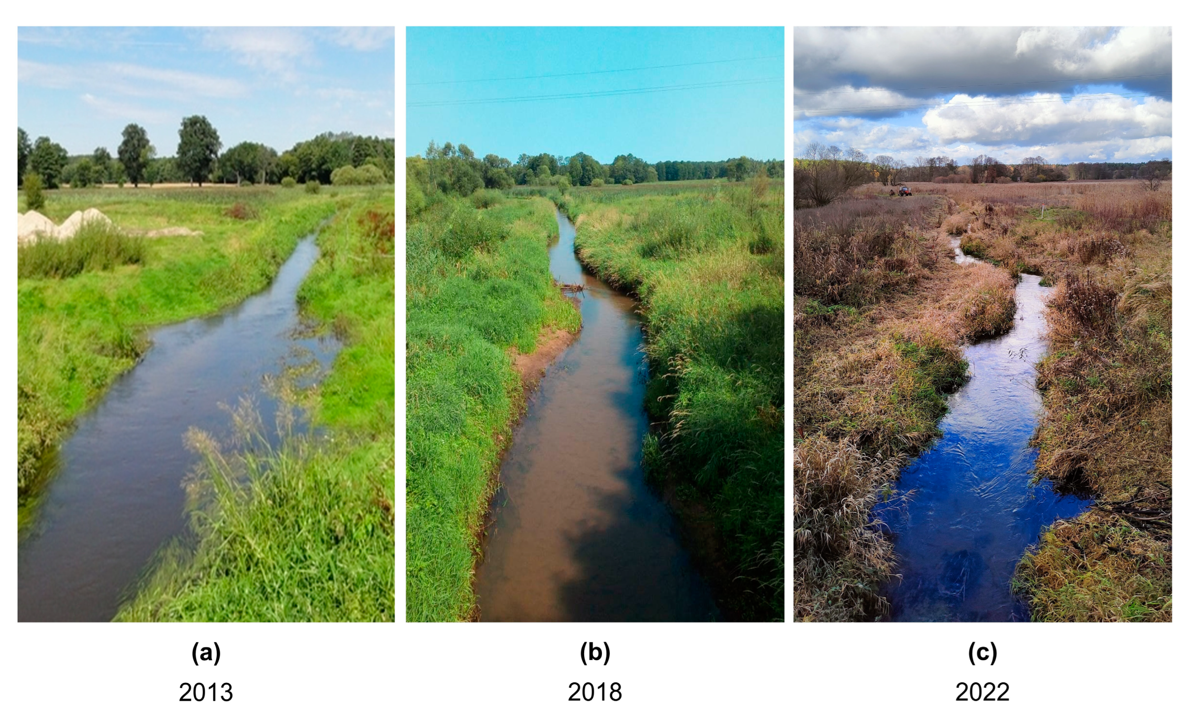
- Regular maintenance work that was carried out on the Flinta River (section B) resulted in a reduced diversity of macrophytes and various other hydromorphological elements of the riverbed. The work has also contributed to the significant degradation of the river in terms of its ecological status (poor status was identified shortly after the desilting and removal of vegetation).
- The seven years of spontaneous restoration and the introduction of deflectors in 2018 enabled a significant improvement in the quality of the watercourse in section B. An increase in the heterogeneity of the riverbed was observed, along with an increase in the amount of erosive and accumulative forms in the researched section, as well as an overall improvement in the hydromorphological status. The assessment conducted in 2022 showed that the hydromorphological status was very good.
- Deflectors introduced into a lowland river cause a deformation of the streamline, an increase in the velocity of the flow, and an initiation of the processes of lateral and vertical erosion downstream of the deflector, as well as the accumulation of sediment on the convex bank. They are also associated with changes in granularity, which can be significant for macroinvertebrates and ichthyofauna.
- Studies of macrophytes showed that their ecological status was relatively stable. The desilting carried out in 2011 had a high impact on the quality of the environment, causing the mechanical removal of about 60% of species occurring in it and leading to a drastic drop in their coverage (to approximately 2.5%). The introduction of deflectors contributed to the increase in the biodiversity of macrophyte species. A continual improvement in the ecological status was also observed until a good status was achieved in 2022.
- The research carried out in the reference section (A) situated approx. 600 m upstream of the research section (B), on which no regulation work has been carried out, showed that it displayed hydrodynamic balance. Regardless of the continual natural changes taking place in the riverbed, it was observed that the dynamic of these changes was significantly smaller than in the section with deflectors. The good ecological status of this section can be regarded as stable over time. The values of the MIR index in that section ranged between 37.0 and 37.9.
Author Contributions
Funding
Institutional Review Board Statement
Informed Consent Statement
Data Availability Statement
Conflicts of Interest
References
- Water Framework Directive (WFD 2000). Directive 2000/60/EC of the European Parliament and of the Council of 23 October 2000 Establishing a Framework for Community Action in the Field of Water Policy. Available online: https://eur-lex.europa.eu/LexUriServ/LexUriServ.do?uri=CONSLEG:2000L0060:20011216:EN:PDF (accessed on 24 February 2023).
- Canfield, K.N. A Review of River Restoration: Political, Social, and Economic Perspectives. Soc. Nat. Resour. 2022, 35, 813–815. [Google Scholar] [CrossRef]
- Grabowski, R.C.; Gurnell, A.M. Hydrogeomorphology-Ecology Interactions in River Systems: Hydrogeomorphology-Ecology Interactions. River Res. Appl. 2016, 32, 139–141. [Google Scholar] [CrossRef] [Green Version]
- Laks, I.; Szoszkiewicz, K.; Kałuża, T. Analysis of in situ water velocity distributions in the lowland river floodplain covered by grassland and reed marsh habitats-a case study of the bypass channel of Warta River (Western Poland). J. Hydrol. Hydromech. 2017, 65, 325–332. [Google Scholar] [CrossRef] [Green Version]
- Szoszkiewicz, K.; Jusik, S.; Lewin, I.; Czerniawska-Kusza, I.; Kupiec, J.M.; Szostak, M. Macrophyte and macroinvertebrate patterns in unimpacted mountain rivers of two European ecoregions. Hydrobiologia 2018, 808, 327–342. [Google Scholar] [CrossRef] [Green Version]
- Zelnik, I.; Muc, T. Relationship between Environmental Conditions and Structure of Macroinvertebrate Community in a Hydromorphologically Altered Pre-Alpine River. Water 2020, 12, 2987. [Google Scholar] [CrossRef]
- Szałkiewicz, E.; Kałuża, T.; Grygoruk, M. Environmental Flows Assessment for Macroinvertebrates at the River Reach Scale in Different Degrees of Hydromorphological Alteration. Front. Environ. Sci. 2022, 10, 243. [Google Scholar] [CrossRef]
- Gebler, D.; Wiegleb, G.; Szoszkiewicz, K. Integrating river hydromorphology and water quality into ecological status modelling by artificial neural networks. Water Res. 2018, 139, 395–405. [Google Scholar] [CrossRef] [PubMed]
- Tymiński, T.; Kałuża, T. Effect of vegetation on flow conditions in the “nature-like” fishways. Rocz. Ochr. Srodowiska 2013, 15, 348–360. [Google Scholar]
- Bockelmann, B.; Fenrich, E.; Lin, B.; Falconer, R. Development of an ecohydraulics model for stream and river restoration. Ecol. Eng. 2004, 22, 227–235. [Google Scholar] [CrossRef]
- Raven, P.; Holmes, N.; Dawson, F.; Everard, M. Quality assessment using River Habitat Survey data. Aquat. Conserv. Mar. Freshw. Ecosyst. 1998, 8, 477–499. [Google Scholar] [CrossRef]
- Walczak, N.; Walczak, Z.; Kałuża, T.; Hämmerling, M.; Stachowski, P. The Impact of Shrubby Floodplain Vegetation Growth on the Discharge Capacity of River Valleys. Water 2018, 10, 556. [Google Scholar] [CrossRef] [Green Version]
- Li, P.; Li, D.; Sun, X.; Chu, Z.; Xia, T.; Zheng, B. Application of Ecological Restoration Technologies for the Improvement of Biodiversity and Ecosystem in the River. Water 2022, 14, 1402. [Google Scholar] [CrossRef]
- Cao, Z.; Hu, P.; Pender, G. Multiple Time Scales of Fluvial Processes with Bed Load Sediment and Implications for Mathematical Modeling. J. Hydraul. Eng. 2011, 137, 267–276. [Google Scholar] [CrossRef]
- Clilverd, H.M.; Thompson, J.R.; Heppell, C.M.; Sayer, C.D.; Axmacher, J.C. Coupled Hydrological/Hydraulic Modelling of River Restoration Impacts and Floodplain Hydrodynamics. River Res. Appl. 2016, 32, 1927–1948. [Google Scholar] [CrossRef]
- Caroppi, G.; Gualtieri, P.; Fontana, N.; Giugni, M. Effects of vegetation density on shear layer in partly vegetated channels. J. Hydro-Environ. Res. 2020, 30, 82–90. [Google Scholar] [CrossRef]
- Prus, P.; Popek, Z.; Pawlaczyk, P. Good Practices for River Maintenance; WWF Polska: Warszawa, Poland, 2018; ISBN 978-83-62069-49-1. (In Polish) [Google Scholar]
- Kupilas, B.; Hering, D.; Lorenz, A.W.; Knuth, C.; Gücker, B. Hydromorphological restoration stimulates river ecosystem metabolism. Biogeosciences 2017, 14, 1989–2002. [Google Scholar] [CrossRef] [Green Version]
- Wyżga, B.; Zawiejska, J.; Radecki-Pawlik, A.; Hajdukiewicz, H. Environmental change, hydromorphological reference condi-tions and the restoration of Polish Carpathian rivers. Earth Surf. Process. Landf. 2012, 37, 1213–1226. [Google Scholar] [CrossRef]
- Wyżga, B.; Oglęcki, P.; Hajdukiewicz, H.; Zawiejska, J.; Radecki-Pawlik, A.; Skalski, T.; Mikuś, P. Interpretation of the inver-tebrate-based BMWP-PL index in a gravel-bed river: Insight from the Polish Carpathians. Hydrobiologia 2013, 712, 71–88. [Google Scholar] [CrossRef]
- Roni, B.; Beechie, T. Introduction to Restoration: Key Steps for Designing Effective Programs and Projects. In Stream and Watershed Restoration, A Guide to Restoring Riverine Processes and Habitats; Roni, P., Beechie, T., Eds.; Willey-Blackwell: Hoboken, NJ, USA, 2012; pp. 1–11. [Google Scholar]
- Hammersmark, C.T.; Dobrowski, S.Z.; Rains, M.; Mount, J.F. Simulated Effects of Stream Restoration on the Distribution of Wet-Meadow Vegetation. Restor. Ecol. 2009, 18, 882–893. [Google Scholar] [CrossRef]
- Brierley, G.; Fryirs, K. Geomorphology and River Management: Applications of the River Styles Framework; Blackwell Publishing: Malden, MA, USA, 2005. [Google Scholar]
- Wohl, E.; Lane, S.N.; Wilcox, A.C. The science and practice of river restoration. Water Resour. Res. 2015, 51, 5974–5997. [Google Scholar] [CrossRef] [Green Version]
- Kail, J.; Hering, D.; Muhar, S.; Gerhard, M.; Preis, S. The use of large wood in stream restoration: Experiences from 50 projects in Germany and Austria. J. Appl. Ecol. 2007, 44, 1145–1155. [Google Scholar] [CrossRef]
- Brandimarte, L.; Di Baldassarre, G. Uncertainty in design flood profiles derived by hydraulic modelling. Hydrol. Res. 2012, 43, 753–761. [Google Scholar] [CrossRef] [Green Version]
- Grabowski, R.C.; Gurnell, A.M.; Burgess-Gamble, L.; England, J.; Holland, D.; Klaar, M.J.; Morrissey, I.; Uttley, C.; Wharton, G. The current state of the use of large wood in river restoration and management. Water Environ. J. 2019, 33, 366–377. [Google Scholar] [CrossRef]
- Lenar-Matyas, A.; Lafont, M.; Lapuszek, M.; Poulard, C. Alleviating effects of technical training of mountainous rivers and streams in urban areas. Infrastruct. Ecol. Rural Areas 2009, 9, 241–251. [Google Scholar]
- Biron, P.M.; Robson, C.; Lapointe, M.F.; Gaskin, S.J. Deflector Designs for Fish Habitat Restoration. Environ. Manag. 2004, 33, 25–35. [Google Scholar] [CrossRef]
- Rana, S.M.; Scott, D.T.; Hester, E.T. Effects of in-stream structures and channel flow rate variation on transient storage. J. Hydrol. 2017, 548, 157–169. [Google Scholar] [CrossRef] [Green Version]
- Pan, B.; Yuan, J.; Zhang, X.; Wang, Z.; Chen, J.; Lu, J.; Yang, W.; Li, Z.; Zhao, N.; Xu, M. A review of ecological restoration techniques in fluvial rivers. Int. J. Sediment Res. 2016, 31, 110–119. [Google Scholar] [CrossRef]
- Wiergocka, M.; Połoński, P. “Demelioration” in the Catchment Area of the Rivers Wda and Trzebiocha (Wdzydze Landscape Park). Przegląd Przyr. 1996, 3–4, 199–206. (In Polish) [Google Scholar]
- Obolewski, K. Short-Term Ecological Effects of Restoration of Small Lowland Rivers on the Example of the Kwacza River; Park Krajobrazowy Dolina Słupi” i Akademia Pomorska w Słupsku: Słupsk, Poland, 2009; ISBN 978-83-930112-0-9. (In Polish) [Google Scholar]
- Szałkiewicz, E.; Dysarz, T.; Kałuża, T.; Malinger, A.; Radecki-Pawlik, A. Analysis of in-stream restoration structures impact on hydraulic condition and sedimentation in the flinta river, poland. Carpathian J. Earth Environ. Sci. 2019, 14, 275–286. [Google Scholar] [CrossRef]
- Paluch, J. Impact of the activity of water companies existing in the 19th and early 20th centuries in the area of the river Wełna basin on the state of its hydrography and water relations. In Proceedings of the Ecological Problems of the Wełna River Basin-State and Directions of Activities Conference, Wągrowiec, Poland, 20 October 2009. [Google Scholar]
- Wody Polskie. Krajowy program renaturyzacji wód powierzchniowych; Wody Polskie: Warszawa, Poland, 2020.
- Zaborowski, S.; Kałuża, T.; Rybacki, M.; Radecki-Pawlik, A. Influence of river channel deflector hydraulic structures on lowland river roughness coefficient values: The Flinta river, Wielkopolska Province, Poland. Ecohydrol. Hydrobiol. 2023, 23, 79–97. [Google Scholar] [CrossRef]
- Kałuża, T.; Radecki-Pawlik, A.; Szoszkiewicz, K.; Plesiński, K.; Radecki-Pawlik, B.; Laks, I. Plant basket hydraulic structures (PBHS) as a new river restoration measure. Sci. Total. Environ. 2018, 627, 245–255. [Google Scholar] [CrossRef]
- Pagliara, S.; Kurdistani, S.M. Flume experiments on scour downstream of wood stream restoration structures. Geomorphology 2017, 279, 141–149. [Google Scholar] [CrossRef]
- Szoszkiewicz, K.; Jusik, S.; Gebler, D.; Achtenberg, K.; Adynkiewicz-Piragas, M.; Radecki-Pawlik, A.A.; Okruszko, T.; Pietruczuk, K.; Przesmycki, M.; Nawrocki, P. Hydromorphological Index for Rivers: A New Method for Hydromorphological Assessment and Classification for Flowing Waters in Poland. J. Ecol. Eng. 2020, 21, 261–271. [Google Scholar] [CrossRef]
- Erba, S.; Buffagni, A.; Holmes, N.; O’Hare, M.; Scarlett, P.; Stenico, A. Preliminary testing of River Habitat Survey features for the aims of the WFD hydro-morphological assessment: An overview from the STAR Project. Hydrobiologia 2006, 566, 281–296. [Google Scholar] [CrossRef]
- FAO. Regulation on the Classification of Ecological Status, Ecological Potential, Chemical Status and the Method of Classifying the Status of Surface Water Bodies as Well as Environmental Quality Standards for Priority Substances. Available online: https://isap.sejm.gov.pl/isap.nsf/download.xsp/WDU20210001475/O/D20211475.pdf (accessed on 24 February 2023).
- Szoszkiewicz, K.; Jusik, S.; Pietruczuk, K.; Gebler, D. The Macrophyte Index for Rivers (MIR) as an Advantageous Approach to Running Water Assessment in Local Geographical Conditions. Water 2020, 12, 108. [Google Scholar] [CrossRef] [Green Version]
- Madsen, J.D.; Wersal, R.M. A review of aquatic plant monitoring and assessment methods. J. Aquat. Plant Manag. 2017, 55, 1–12. [Google Scholar]
- Shannon, C.E. The Mathematical Theory of Communication; University of Illinois Press: Urbana, IL, USA, 1949; pp. 1–117. [Google Scholar]
- Yi, Y.; Cheng, X.; Wieprecht, S.; Tang, C. Comparison of habitat suitability models using different habitat suitability evaluation methods. Ecol. Eng. 2014, 71, 335–345. [Google Scholar] [CrossRef]
- Teufl, B.; Weigelhofer, G.; Fuchsberger, J.; Hein, T. Effects of hydromorphology and riparian vegetation on the sediment quality of agricultural low-order streams: Consequences for stream restoration. Environ. Sci. Pollut. Res. 2012, 20, 1781–1793. [Google Scholar] [CrossRef]
- Radecki-Pawlik, A.; Bucała, A.; Plesiński, K.; Oglęcki, P. Ecohydrological conditions in two catchments in the Gorce Mountains: Jaszcze and Jamne streams–Western Polish Carpathians. Ecohydrol. Hydrobiol. 2014, 14, 229–242. [Google Scholar] [CrossRef]
- Comín, F.A.; Miranda, B.; Sorando, R.; Felipe-Lucia, M.R.; Jiménez, J.J.; Navarro, E. Prioritizing sites for ecological restoration based on ecosystem services. J. Appl. Ecol. 2018, 55, 1155–1163. [Google Scholar] [CrossRef]
- Thompson, D.M. Long-Term Effect of Instream Habitat-Improvement Structures on Channel Morphology Along the Blackledge and Salmon Rivers, Connecticut, USA. Environ. Manag. 2002, 29, 250–265. [Google Scholar] [CrossRef]
- McDonald, T.; Gann, G.D.; Jonson, K.; Dixon, K.W. International standards for the practice of ecological restoration–Including principles and key concepts; Society for Ecological Restoration: Washington, DC, USA, 2016. [Google Scholar]
- Wortley, L.; Hero, J.-M.; Howes, M. Evaluating Ecological Restoration Success: A Review of the Literature. Restor. Ecol. 2013, 21, 537–543. [Google Scholar] [CrossRef]
- Dufour, S.; Piégay, H. From the myth of a lost paradise to targeted river restoration: Forget natural references and focus on human benefits. River Res. Appl. 2009, 25, 568–581. [Google Scholar] [CrossRef]
- Choi, Y. Theories for ecological restoration in changing environment: Toward futuristic restoration. Ecol. Res. 2004, 19, 75–81. [Google Scholar] [CrossRef]
- Comín, F.A.; Menéndez, M.; Pedrocchi, C.; Moreno, S.; Sorando, R.; Cabezas, A.; García, M.G.; Rosas, V.; Moreno, D.; Gonzalez, E.; et al. Wetland Restoration: Integrating Scientific-Technical, Economic, and Social Perspectives. Ecol. Restor. 2005, 23, 182–186. [Google Scholar] [CrossRef]
- Rodrigues, R.R.; Gandolfi, S.; Nave, A.G.; Aronson, J.; Barreto, T.E.; Vidal, C.Y.; Brancalion, P.H. Large-scale ecological restoration of high-diversity tropical forests in SE Brazil. For. Ecol. Manag. 2011, 261, 1605–1613. [Google Scholar] [CrossRef]
- Szałkiewicz, E.; Jusik, S.; Grygoruk, M. Status of and Perspectives on River Restoration in Europe: 310,000 Euros per Hectare of Restored River. Sustainability 2018, 10, 129. [Google Scholar] [CrossRef] [Green Version]
- Perring, M.P.; Standish, R.J.; Price, J.N.; Craig, M.D.; Erickson, T.E.; Ruthrof, K.X.; Whiteley, A.S.; Valentine, L.E.; Hobbs, R.J. Advances in restoration ecology: Rising to the challenges of the coming decades. Ecosphere 2015, 6, art131. [Google Scholar] [CrossRef] [Green Version]
- Szoszkiewicz, K.; Ferreira, T.; Korte, T.; Baattrup-Pedersen, A.; Davy-Bowker, J.; O’Hare, M. European river plant communities: The importance of organic pollution and the usefulness of existing macrophyte metrics. Hydrobiologia 2006, 566, 211–234. [Google Scholar] [CrossRef]
- Bączyk, A.; Wagner, M.; Okruszko, T.; Grygoruk, M. Influence of technical maintenance measures on ecological status of agricultural lowland rivers–Systematic review and implications for river management. Sci. Total. Environ. 2018, 627, 189–199. [Google Scholar] [CrossRef]
- Hachoł, J.; Bondar-Nowakowska, E. An assessment of the ecological status of diverse watercourses of Lower Silesia, Poland. Pol. J. Environ. Stud. 2012, 21, 75–81. [Google Scholar]
- Kałuża, T.; Sojka, M.; Wróżyński, R.; Jaskuła, J.; Zaborowski, S.; Hämmerling, M. Modeling of River Channel Shading as a Factor for Changes in Hydromorphological Conditions of Small Lowland Rivers. Water 2020, 12, 527. [Google Scholar] [CrossRef] [Green Version]
- Jusik, S.; Staniszewski, R. Shading of River Channels as an Important Factor Reducing Macrophyte Biodiversity. Pol. J. Environ. Stud. 2019, 28, 1215–1222. [Google Scholar] [CrossRef] [PubMed]
- Jahadi, M.; Afzalimehr, H.; Rowinski, P.M. Flow structure within a vegetation patch in a gravel-bed river. J. Hydrol. Hydromech. 2019, 67, 154–162. [Google Scholar] [CrossRef] [Green Version]
- Guo, J.; Zhang, J. Velocity distributions in laminar and turbulent vegetated flows. J. Hydraul. Res. 2016, 54, 117–130. [Google Scholar] [CrossRef]
- Gurnell, A. Plants as river system engineers. Earth Surf. Process. Landf. 2014, 39, 4–25. [Google Scholar] [CrossRef]
- Belmar, O.; Velasco, J.; Martinez-Capel, F. Hydrological Classification of Natural Flow Regimes to Support Environmental Flow Assessments in Intensively Regulated Mediterranean Rivers, Segura River Basin (Spain). Environ. Manag. 2011, 47, 992–1004. [Google Scholar] [CrossRef] [Green Version]
- Monk, W.A.; Wood, P.J.; Hannah, D.M.; Wilson, D.A. Selection of river flow indices for the assessment of hydroecological change. River Res. Appl. 2007, 23, 113–122. [Google Scholar] [CrossRef] [Green Version]
- Wałęga, A.; Kędzior, R.; Książek, L.; Młyński, D.; Strużyński, A.; Grela, J.; Madej, P.; Skalski, T. Flow predictability indicates the ecological quality of the river: A case of invertebrates in Central Europe. Ecol. Indic. 2022, 143, 109308. [Google Scholar] [CrossRef]
- Palmer, M.; Ruhi, A. Linkages between flow regime, biota, and ecosystem processes: Implications for river restoration. Science 2019, 365, eaaw2087. [Google Scholar] [CrossRef] [Green Version]
- Gorczyca, E.; Wąs, J. Spontaneous restoration of mountain rivers and streams. In Processes and the Maintenance of Rivers and Mountain Streams; Gorczyca, E., Radecki-Pawlik, A., Krzemień, K., Eds.; Uniwersytet Jagielloński: Kraków, Poland, 2022; pp. 393–414. ISBN 978-83-64089-68-8. (In Polish) [Google Scholar]
- Ptak, M.; Sojka, M.; Kałuża, T.; Choiński, A.; Nowak, B. Long-term water temperature trends of the Warta River in the years 1960–2009. Ecohydrol. Hydrobiol. 2019, 19, 441–451. [Google Scholar] [CrossRef]
- IPCC. Climate Change 2022: Impacts, Adaptation and Vulnerability. In Contribution of Working Group II to the Sixth Assessment Report of the Intergovernmental Panel on Climate Change; Pörtner, H.-O., Roberts, D., Tignor, M., Poloczanska, E., Mintenbeck, K., Alegría, A., Craig, M., Langsdorf, S., Löschke, S., Möller, V., et al., Eds.; Cambridge University Press: Cambridge, UK; New York, NY, USA, 2022; p. 3056. [Google Scholar] [CrossRef]
- Kejna, M.; Rudzki, M. Spatial diversity of air temperature changes in Poland in 1961–2018. Theor. Appl. Clim. 2021, 143, 1361–1379. [Google Scholar] [CrossRef]
- Szwed, M. Variability of precipitation in Poland under climate change. Theor. Appl. Clim. 2019, 135, 1003–1015. [Google Scholar] [CrossRef] [Green Version]


| Characteristic Flows [m3·s−1] | ||||||||
|---|---|---|---|---|---|---|---|---|
| NNQ | SNQ | WNQ | NSQ | SSQ | WSQ | NWQ | SWQ | WWQ |
| 0.01 | 0.10 | 0.41 | 0.24 | 0.66 | 1.72 | 0.77 | 3.26 | 7.28 |
Disclaimer/Publisher’s Note: The statements, opinions and data contained in all publications are solely those of the individual author(s) and contributor(s) and not of MDPI and/or the editor(s). MDPI and/or the editor(s) disclaim responsibility for any injury to people or property resulting from any ideas, methods, instructions or products referred to in the content. |
© 2023 by the authors. Licensee MDPI, Basel, Switzerland. This article is an open access article distributed under the terms and conditions of the Creative Commons Attribution (CC BY) license (https://creativecommons.org/licenses/by/4.0/).
Share and Cite
Zaborowski, S.; Kałuża, T.; Jusik, S. The Impact of Spontaneous and Induced Restoration on the Hydromorphological Conditions and Macrophytes, Example of Flinta River. Sustainability 2023, 15, 4302. https://doi.org/10.3390/su15054302
Zaborowski S, Kałuża T, Jusik S. The Impact of Spontaneous and Induced Restoration on the Hydromorphological Conditions and Macrophytes, Example of Flinta River. Sustainability. 2023; 15(5):4302. https://doi.org/10.3390/su15054302
Chicago/Turabian StyleZaborowski, Stanisław, Tomasz Kałuża, and Szymon Jusik. 2023. "The Impact of Spontaneous and Induced Restoration on the Hydromorphological Conditions and Macrophytes, Example of Flinta River" Sustainability 15, no. 5: 4302. https://doi.org/10.3390/su15054302