
Exploration of Intelligent Building Planning for Urban Renewal


Abstract
:1. Introduction
2. Data and Methods
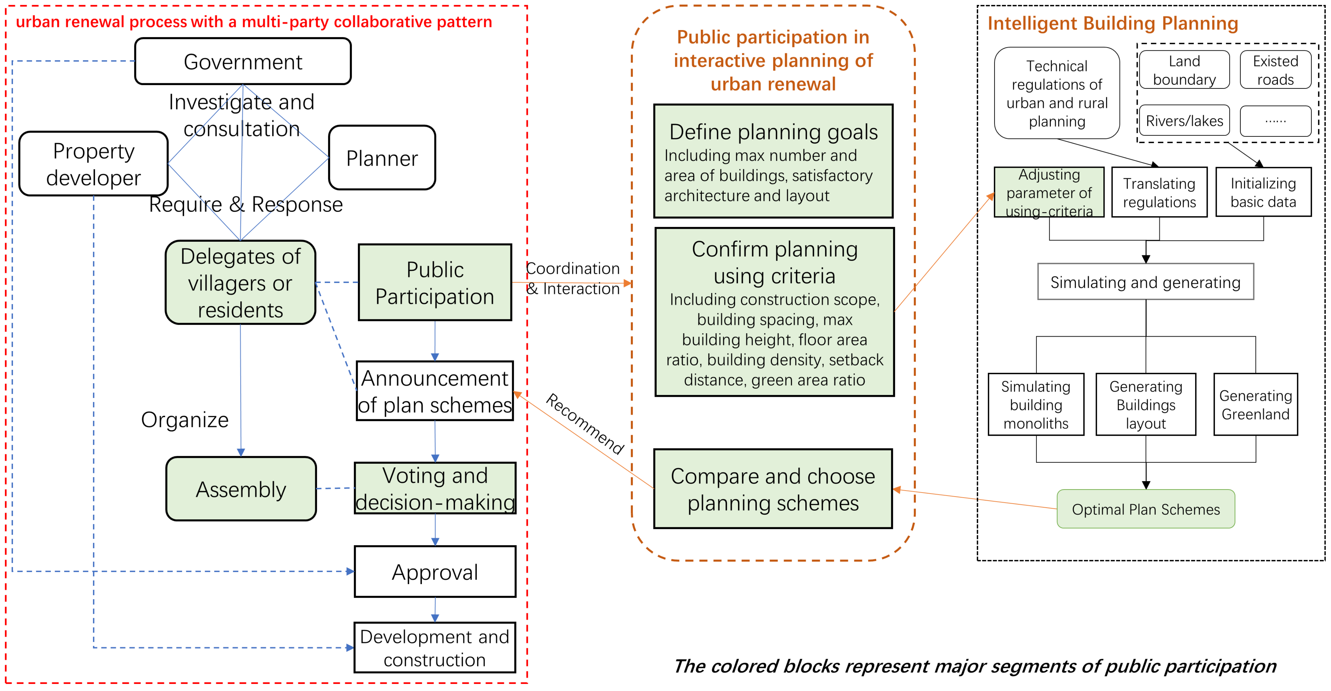
2.1. Framework of Study
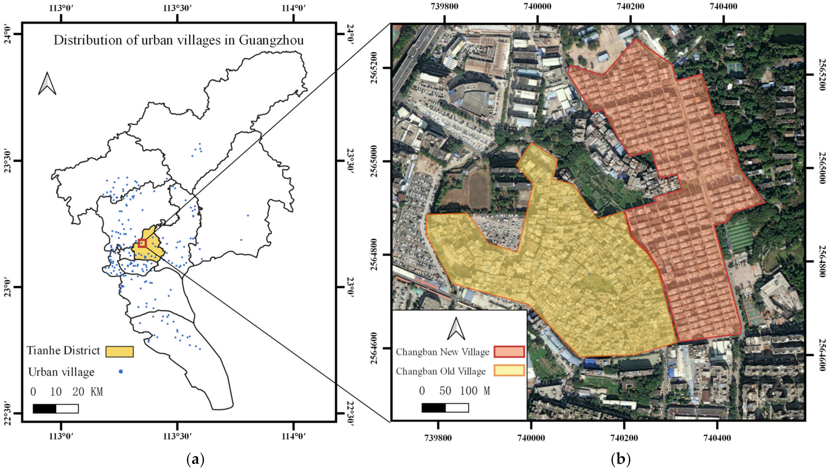
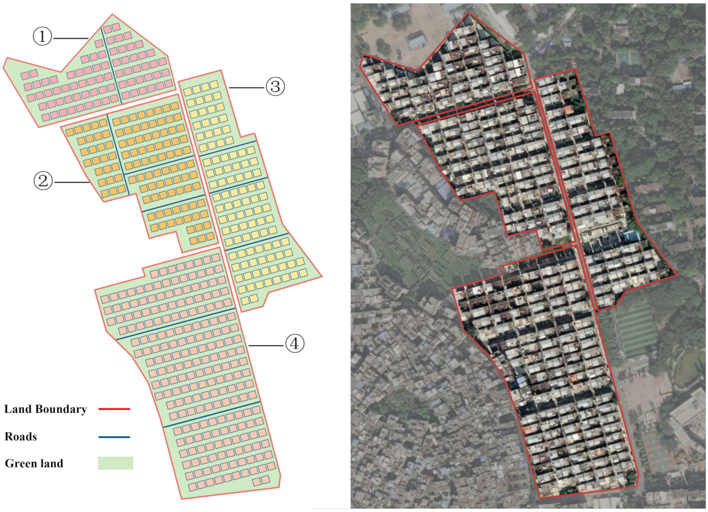
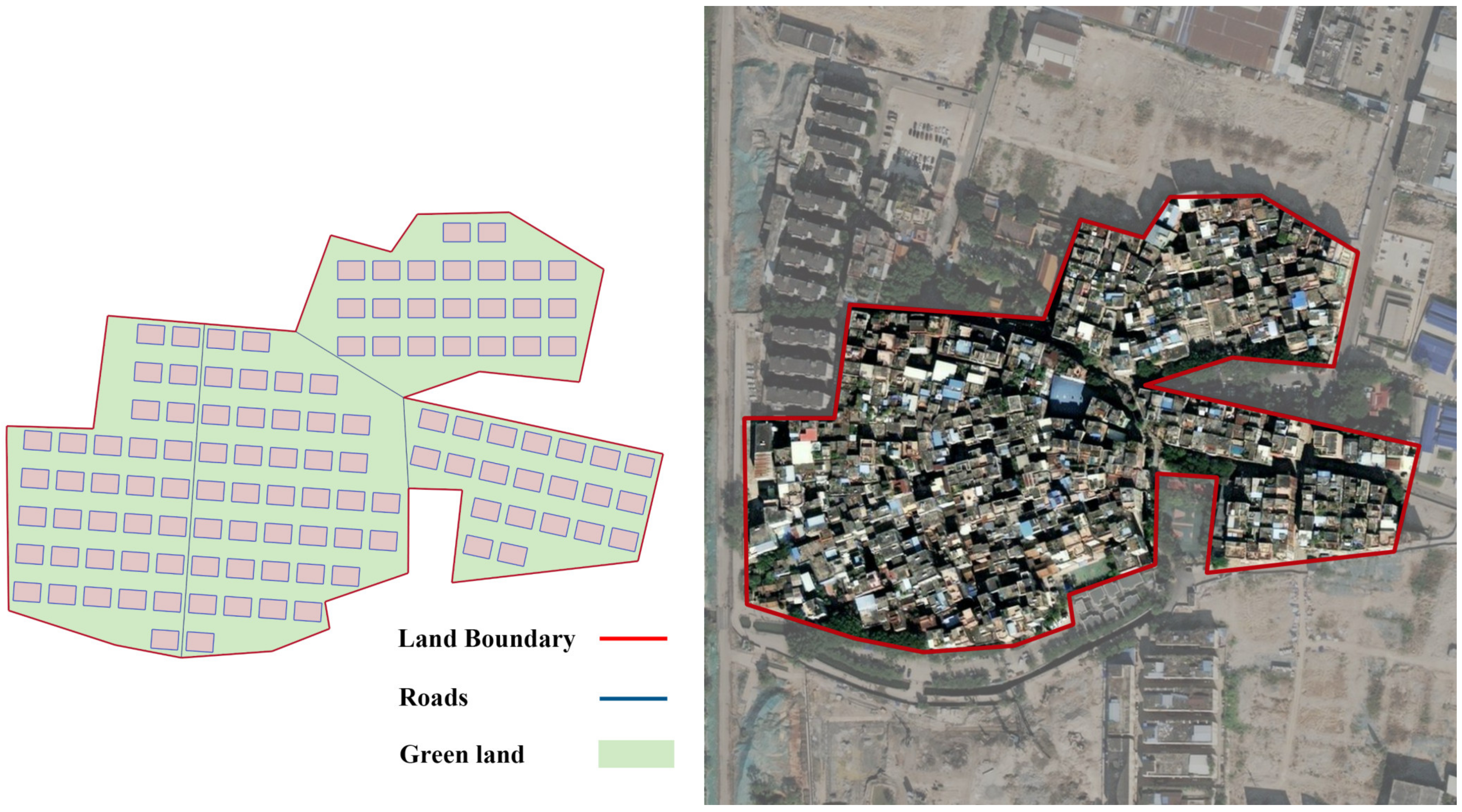
2.2. Case Study of Urban Renewal
2.3. Criteria for Translating the Design Specifications
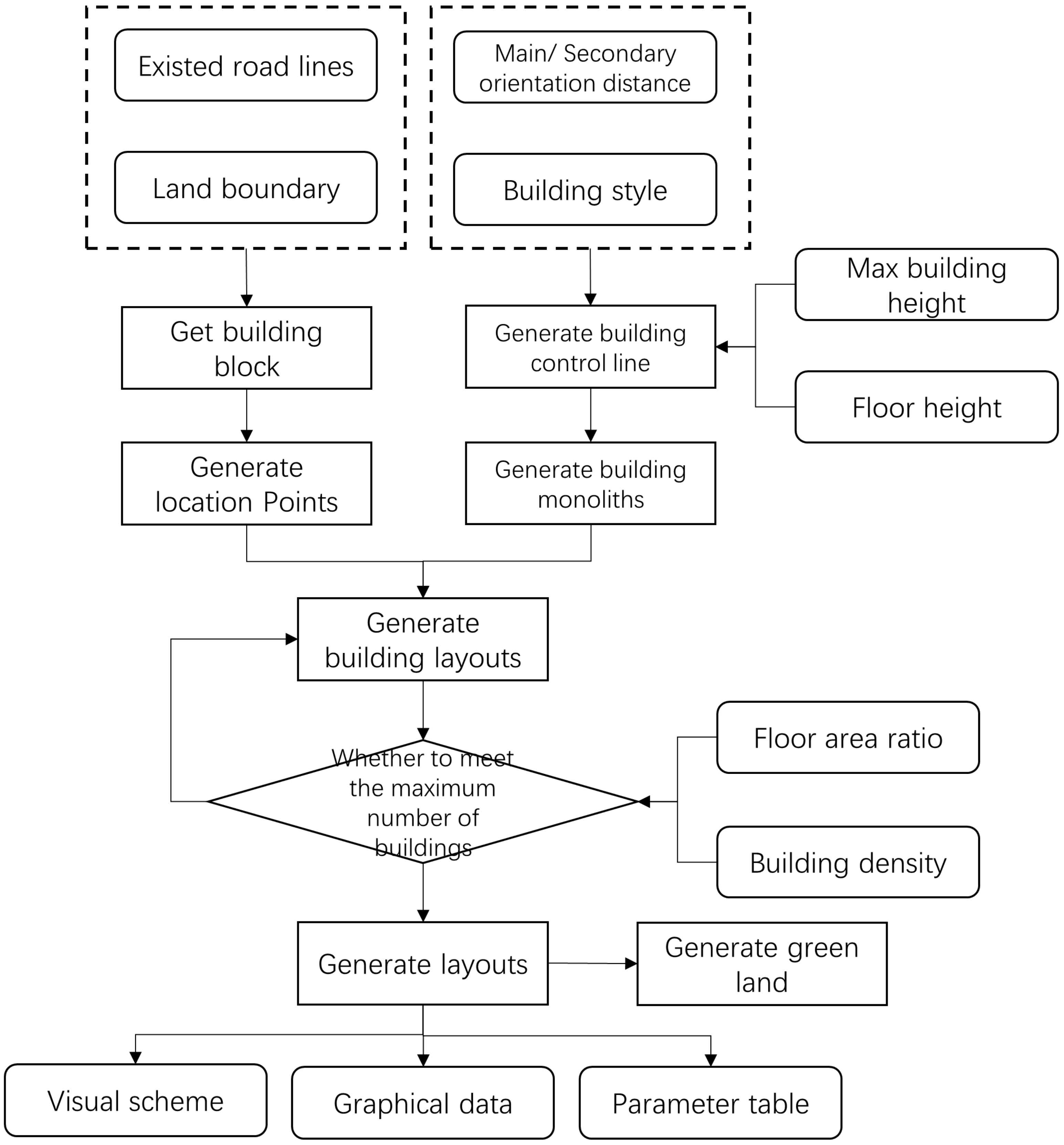
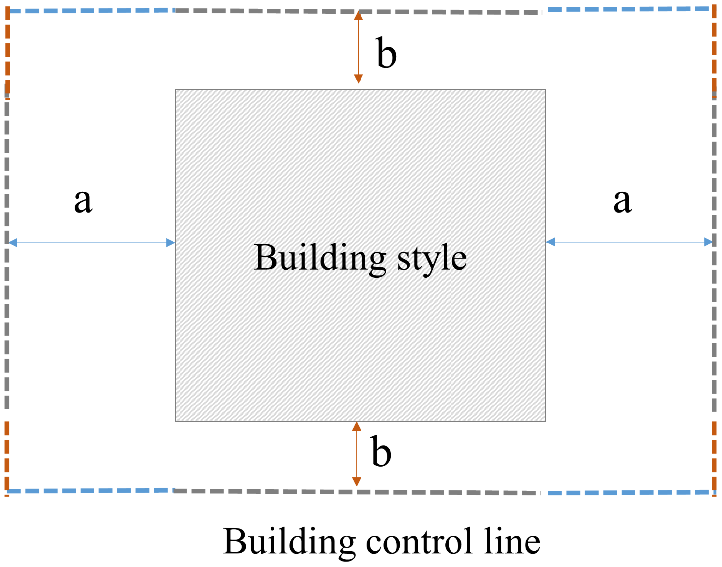
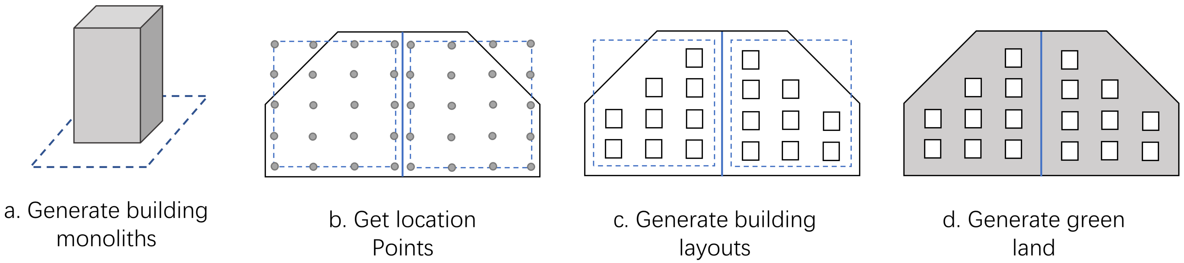
2.4. Building Planning Algorithm and Its Implementation
3. Results
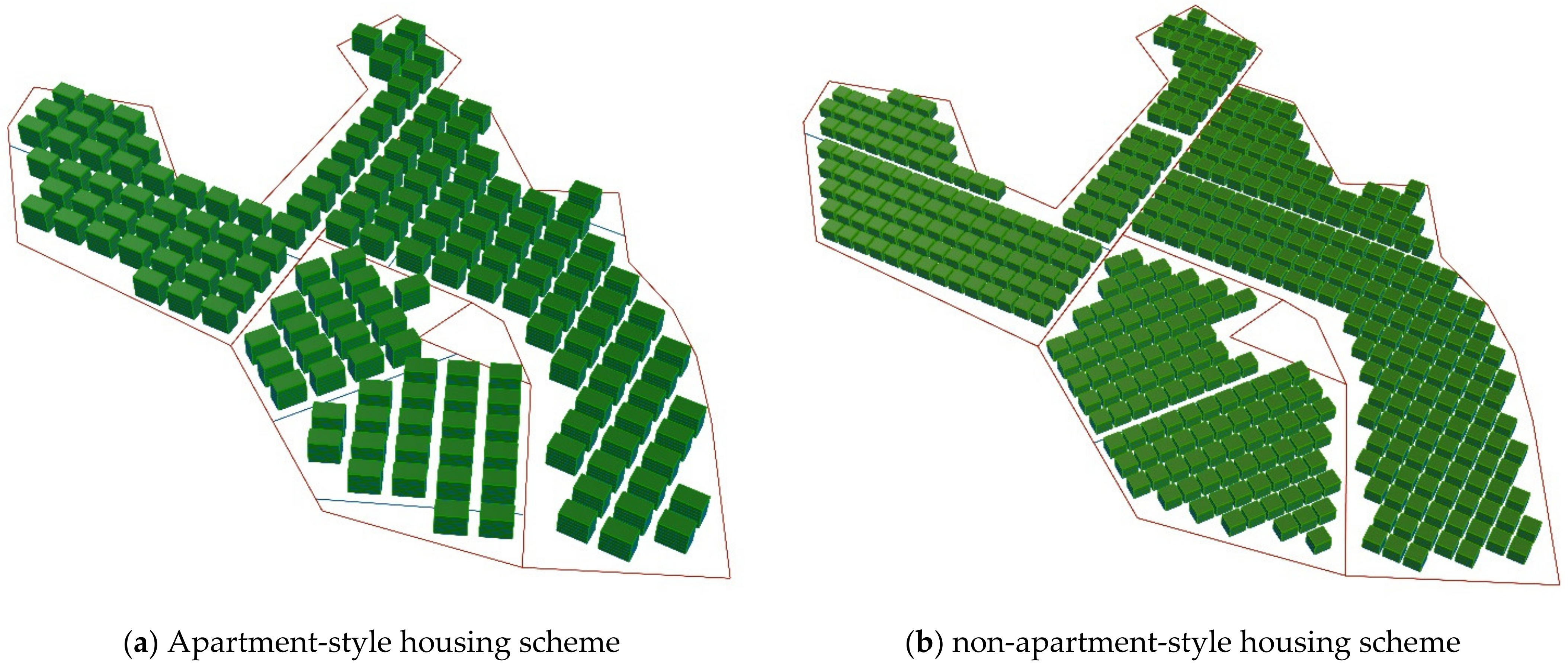
4. Discussion
5. Conclusions
Author Contributions
Funding
Institutional Review Board Statement
Informed Consent Statement
Data Availability Statement
Acknowledgments
Conflicts of Interest
References
- Tangrt, W.-S.; Chung, H. Rural-urban transition in China: Illegal land use and construction. Asia Pac. Viewp. 2002, 43, 43–62. [Google Scholar] [CrossRef]
- Klassen, T.; Cepiku, D.; Lah, T.J. The Routledge Handbook of Global Public Policy and Administration; Routledge: London, UK, 2017; pp. 80–91. [Google Scholar]
- Cai, Y. Collective ownership or cadres’ ownership? The non-agricultural use of farmland in China. China Q. 2003, 175, 662–680. [Google Scholar] [CrossRef]
- Song, Y.; Zenou, Y.; Ding, C. Let’s not throw the baby out with the bath water: The role of urban villages in housing rural migrants in China. Urban Stud. 2008, 45, 313–330. [Google Scholar] [CrossRef] [Green Version]
- Xu, Z.; Gao, X.; Wang, Z.; Gilroy, R.; Wu, H. An investigation of non-local-governed urban villages in China from the perspective of the administrative system. Habitat Int. 2018, 74, 27–35. [Google Scholar] [CrossRef]
- Huang, X.; Li, J.; Yang, J.; Zhang, Z.; Li, D.; Liu, X. 30 m global impervious surface area dynamics and urban expansion pattern observed by Landsat satellites: From 1972 to 2019. Sci. China Earth Sci. 2021, 64, 1922–1933. [Google Scholar] [CrossRef]
- Liu, J.; Song, Y.; Liu, Y. Institutional innovation and sustainable development: A study of governance institutions in peri-urban China. Urban Plan. Forum 1998, 4, 42–45. [Google Scholar]
- Huang, D.; Huang, Y.; Zhao, X.; Liu, Z. How do differences in land ownership types in China affect land development? A Case from Beijing. Sustainability 2017, 9, 123. [Google Scholar] [CrossRef] [Green Version]
- Hao, P.; Hooimeijer, P.; Sliuzas, R.; Geertman, S. What drives the spatial development of urban villages in China? Urban Stud. 2013, 50, 3394–3411. [Google Scholar] [CrossRef]
- Zhang, L.; Zhao, S.X.B.; Tian, J.P. Self-help in housing and Chengzhongcun in China’s urbanization. Int. J. Urban Reg. Res. 2003, 27, 912–937. [Google Scholar] [CrossRef]
- Lai, Y.; Jiang, L.; Xu, X. Exploring spatio-temporal patterns of urban village redevelopment: The case of Shenzhen, China. Land 2021, 10, 976. [Google Scholar] [CrossRef]
- Wong, S.W.; Tang, B.-S.; Liu, J. Village redevelopment and desegregation as a strategy for metropolitan development: Some lessons from Guangzhou City. Int. J. Urban Reg. Res. 2018, 42, 1064–1079. [Google Scholar] [CrossRef]
- Tian, L. The Chengzhongcun land market in China: Boon or bane?—A perspective on property rights. Int. J. Urban Reg. Res. 2008, 32, 282–304. [Google Scholar] [CrossRef]
- Wu, Y.; Sun, X.; Sun, L.; Choguill, C.L. Optimizing the governance model of urban villages based on integration of inclusiveness and urban service boundary (USB): A Chinese case study. Cities 2020, 96, 102427. [Google Scholar] [CrossRef]
- Liu, R.; Wong, T.-C. Urban village redevelopment in Beijing: The state-dominated formalization of informal housing. Cities 2018, 72, 160–172. [Google Scholar] [CrossRef]
- Li, L.H.; Lin, J.; Li, X.; Wu, F. Redevelopment of urban village in China—A step towards an effective urban policy? A case study of Liede village in Guangzhou. Habitat Int. 2014, 43, 299–308. [Google Scholar] [CrossRef]
- Liu, X.; Huang, J.; Zhu, J. Property-rights regime in transition: Understanding the urban regeneration process in China—A case study of Jinhuajie, Guangzhou. Cities 2019, 90, 181–190. [Google Scholar] [CrossRef]
- Shi, C.; Tang, B. Institutional change and diversity in the transfer of land development rights in China: The case of Chengdu. Urban Stud. 2019, 57, 473–489. [Google Scholar] [CrossRef]
- Yang, Q.; Song, Y.; Cai, Y. Blending bottom-up and top-down urban village redevelopment modes: Comparing multidimensional welfare changes of resettled households in Wuhan, China. Sustainability 2020, 12, 7447. [Google Scholar] [CrossRef]
- Lin, Y.; Hao, P.; Geertman, S. A conceptual framework on modes of governance for the regeneration of Chinese ‘villages in the city’. Urban Stud. 2014, 52, 1774–1790. [Google Scholar] [CrossRef]
- Guo, Y.; Zhang, C.; Wang, Y.P.; Li, X. (De-)Activating the growth machine for redevelopment: The case of Liede urban village in Guangzhou. Urban Stud. 2017, 55, 1420–1438. [Google Scholar] [CrossRef]
- Liu, G.; Wei, L.; Gu, J.; Zhou, T.; Liu, Y. Benefit distribution in urban renewal from the perspectives of efficiency and fairness: A game theoretical model and the government’s role in China. Cities 2020, 96, 102422. [Google Scholar] [CrossRef]
- Zhou, Z. Towards collaborative approach? Investigating the regeneration of urban village in Guangzhou, China. Habitat Int. 2014, 44, 297–305. [Google Scholar] [CrossRef]
- Jiang, L.; Lai, Y.; Chen, K.; Tang, X. What drives urban village redevelopment in China? A survey of literature based on web of science core collection database. Land 2022, 11, 525. [Google Scholar] [CrossRef]
- Tong, D.; Feng, C.; Li, G.; Chen, P. Categories and characteristics of urban villages by GIS-based analysis: A case study of the Shenzhen Special Economic Zone. Sci. China Technol. Sci. 2010, 53, 150–157. [Google Scholar] [CrossRef]
- Chung, H. Building an image of villages-in-the-City: A clarification of China’s distinct urban spaces. Int. J. Urban Reg. Res. 2010, 34, 421–437. [Google Scholar] [CrossRef]
- Lin, Y.; de Meulder, B.; Wang, S. Understanding the ‘Village in the City’ in Guangzhou. Urban Stud. 2011, 48, 3583–3598. [Google Scholar] [CrossRef]
- Bao, H.; Fang, Y.; Ye, Q.; Peng, Y. Investigating social welfare change in urban village transformation: A rural migrant perspective. Soc. Indicator. Res. 2017, 139, 723–743. [Google Scholar] [CrossRef]
- Jin, X.; Ren, T.; Mao, N.; Chen, L. To stay or to leave? Migrant workers’ decisions during urban village redevelopment in Hangzhou, China. Front. Public Health 2021, 9, 782251. [Google Scholar] [CrossRef] [PubMed]
- Wong, T.-C.; Liu, R. Developmental urbanism, city image branding and the ‘Right to the City’ in transitional China. Urban Policy Res. 2016, 35, 210–223. [Google Scholar] [CrossRef]
- Yuan, D.; Yau, Y.; Bao, H.; Lin, W. A Framework for understanding the institutional arrangements of urban village redevelopment projects in China. Land Use Policy 2020, 99, 104998. [Google Scholar] [CrossRef]
- Ding, Q.; Zhang, T.; Zhu, X.; Zhang, J. Impact of perceived value and community attachment on smart renovation participation willingness for sustainable development of old urban communities in China. Sustainability 2022, 14, 11675. [Google Scholar] [CrossRef]
- Hoseini, S.; Teimory, S. Design health village with the approach of sustainable architecture and utilization of intelligent principles. J. Fundament. Appl. Sci. 2016, 8, 366. [Google Scholar] [CrossRef] [Green Version]
- Zhang, X.; Zhang, Z. How do smart villages become a way to achieve sustainable development in rural areas? smart village planning and practices in China. Sustainability 2020, 12, 10510. [Google Scholar] [CrossRef]
- Hastak, M.; Koo, C. Theory of an intelligent planning unit for the complex-built environment. J. Manag. Eng. 2017, 33, 04016046. [Google Scholar] [CrossRef]
- Chen, X.; Xiong, Y.; Wang, S.; Wang, H.; Sheng, T.; Zhang, Y.; Ye, Y. ReCo: A dataset for residential community layout planning. arXiv 2022, arXiv:2206.04678. [Google Scholar] [CrossRef]
- Kudo, H.; Granier, B. Communications Technologies in Public Administration Can Government Lead ICT Projects Involve Citizens and Change Their Behavior? Lessons From the Japanese Smart Communities. In Proceedings of the 2014 EGPA Annual Conference, Speyer, Germany, 10–12 September 2014. [Google Scholar]
- Dai, X.; Tang, W. Chimerical governance: A practical exploration of “micro-renewal” in old neighborhoods under administrative leadership. Learn. Pract. 2021, 9, 91–101. [Google Scholar]
- Li, K.; Wang, F.; Li, X. Cunzhuang guihua zhong quanfangwei cunmin canyu fangfa yanjiu [Study on approaches of all-round villagers’ participation in village planning: A practice of beautiful countryside planning in Guangzhou city]. City Plan. Rev. 2014, 38, 34–43. [Google Scholar]
- Brabham, D.C. Motivations for participation in a crowdsourcing application to improve public engagement in transit planning. J. Appl. Commun. Res. 2012, 40, 307–328. [Google Scholar] [CrossRef]
- Oni, A.A.; Oni, S.; Mbarika, V.; Ayo, C.K. Empirical study of user acceptance of online political participation: Integrating Civic Voluntarism Model and Theory of Reasoned Action. Gov. Inf. Q. 2017, 34, 317–328. [Google Scholar] [CrossRef]
- Yap, S.F.; Gaur, S.S. Integrating functional, social, and psychological determinants to explain online social networking usage. Behav. Inf. Technol. 2016, 35, 166–183. [Google Scholar] [CrossRef]
- Leao, S.; Izadpahani, P. Factors motivating citizen engagement in mobile sensing: Insights from a survey of non-participants. J. Urban Technol. 2016, 23, 85–103. [Google Scholar] [CrossRef]
- Li, W.; Feng, T.; Timmermans, H.J.; Li, Z.; Zhang, M.; Li, B. Analysis of citizens’ motivation and participation intention in urban planning. Cities 2020, 106, 102921. [Google Scholar] [CrossRef]
- Arnstein, S.R. A ladder of citizen participation. J. Am. Inst. Plann. 1969, 35, 216–224. [Google Scholar] [CrossRef] [Green Version]
- Li, X.; Liu, M.; Huang, Y. A new model of community participation: A case study of “Jointly Development” workshop in Zengcuoan, Xiamen. City Plan. Rev. 2018, 42, 39–44. [Google Scholar]
- Li, X.; Zhang, F.; Hui, E.C.M.; Lang, W. Collaborative workshop and community participation: A new approach to urban regeneration in China. Cities 2020, 102, 102743. [Google Scholar] [CrossRef]
- Zhang, Y.; Ou, M.; Cai, Y. Overall village coordination: An exploration of land use and development issues of urban village. City Plan. Rev. 2015, 39, 93–98+105. [Google Scholar]
- Ertio, T. Participatory Apps for Urban Planning-Space for Improvement. Plan. Pract. Res. 2015, 30, 301–320. [Google Scholar] [CrossRef]
- Linders, D. From e-government to we-government: Defining a typology for citizen coproduction in the age of social media. Gov. Inf. Q. 2012, 29, 446–454. [Google Scholar] [CrossRef]
- Williamson, W.; Parolin, B. Web 2.0 and Social Media Growth in Planning Practice: A Longitudinal Study. Plan. Pract. Res. 2013, 28, 544–562. [Google Scholar] [CrossRef]
- Falco, E.; Kleinhans, R. Digital participatory platforms for co-production in urban development: A systematic review. Crowdsourcing: Concepts Methodol. Tools Appl. 2019, 7, 663–690. [Google Scholar]
- Shea, K.; Aish, R.; Gourtovaia, M. Towards integrated performance-driven generative design tools. Autom. Constr. 2005, 14, 253–264. [Google Scholar] [CrossRef]
- Wang, C. Urban village on a global scale: Diverse interpretations of one label. Urban Geogr. 2020, 43, 184–205. [Google Scholar] [CrossRef]
- Johnson, J. Designing with the Mind in Mind: Simple Guide to Understanding User Interface Design Guidelines; Morgan Kaufmann: San Francisco, CA, USA, 2020; pp. 1–13. [Google Scholar]

| Guangzhou | Shanghai | Beijing | |
|---|---|---|---|
| Longitude and latitude | 113.25E 23.12N | 121.46E 31.22N | 116.40E 39.91N |
| Residential building classification | multi-story building and low-rise building high-rise building farmhouse | multi-story building and low-rise building high-rise building farmhouse | tower-type building plate-type building farmhouse |
| Spacing coefficient | multi-story building and low-rise building: 1.1/0.8/0.5/0.3 high-rise building: 0.8/0.5/0.3 farmhouse: Fixed minimum value | multi-story building and low-rise building: 1.2/1.0/0.8/0.7 high-rise building: 0.5/0.4/0.3 farmhouse: 1.2/1.4 | plate-type building: 1.7/1.6/1.4/1.0 tower-type building: 1.7/1.5/1.2 farmhouse: 1.0 |
| Spacing calculation method | multi-story building and low-rise building: H × Spacing coefficient high-rise building: H × Spacing coefficient farmhouse: Fixed minimum value | H × Spacing coefficient | H × Spacing coefficient |
| Farmhouse constraints | H ≤11 m floors ≤3 | H ≤10 m floors ≤3 | H ≤7.2 m floors ≤2 |
| Rural settlement patterns | 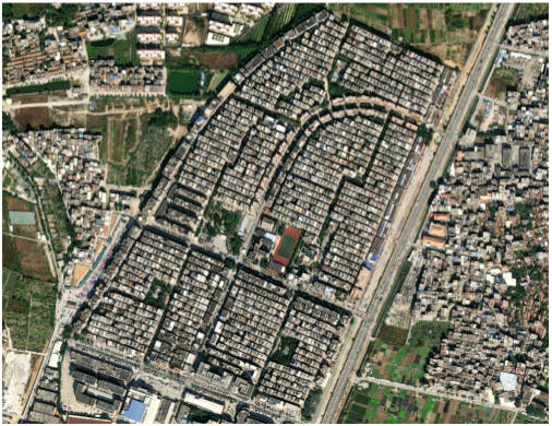 | 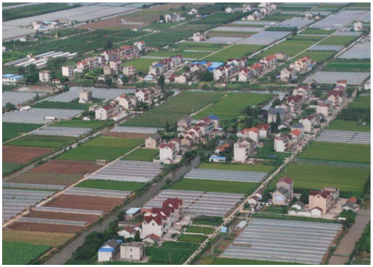 | 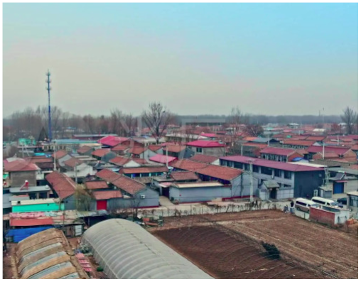 |
| Indicators | Control Ranges | Summarized Ranges |
|---|---|---|
| Maximum building height | Residential: ≤10 m/11 m (Shanghai/Guangzhou rural non-apartment detached houses); 18–80 m (city, national standards) Commercial: ≤12 m (Shanghai): No restrictions on the rest, in harmony with the surrounding environment Industrial: No restrictions on the rest, in harmony with the surrounding environment | Residential: ≤11 m (rural); 18–80 m (city) Commercial: ≤12 m (rural); No limitation on city Industrial: No limitation |
| Building spacing | Residential: Main orientation ≥6 m; minor orientations ≥2 m (Guangzhou) Commercial: ≥10 m (increases with the number of floors) Industrial: ≥13 m (increases with the number of floors) | Residential: Main orientation ≥6 m; minor orientations ≥2 m Commercial: ≥10 m Industrial: ≥13 m |
| Floor area ratio | Residential: ≤1.8 (Guangzhou), ≤2.9 (Guangzhou), 1.0–3.1(national standards) Commercial: 1.0–1.5 (Shanghai) Industrial: ≤4.0 (Guangzhou) | Residential: ≤1.8 (rural), 1.5–6.0 (city) Commercial: 1.0–1.5 (rural), 1.6–15.0 (city) Industrial: ≤4.0 (city/rural) |
| Building density | Residential: ≤50% (Guangzhou) Commercial: ≤60% (Guangzhou) Industrial: 35–50% (Guangzhou) | Residential: ≤50% Commercial: ≤60% Industrial: 35–50% |
| Setback distance | Residential: ≥2 m (rural, Guangzhou), ≥5 m (city, Guangzhou) Commercial: ≥5 m (Guangzhou) Industrial: ≥5 m (Guangzhou) | Residential: ≥2 m (rural); ≥5 m (city) Commercial: ≥5 m (city) Industrial: ≥5 m (city) |
| Green area ratio | Residential: ≥25% (Guangzhou) Commercial: ≥10% (Guangzhou) Industrial: ≤20% (Guangzhou) | Residential: ≥25% Commercial: ≥10% Industrial: ≤20% |
| ① | ② | ③ | ④ | |||||
|---|---|---|---|---|---|---|---|---|
| Simulated | Actual | Simulated | Actual | Simulated | Actual | Simulated | Actual | |
| The land area | 17,740.05 | 17,740.05 | 24,155.51 | 24,155.51 | 25,079.23 | 25,079.23 | 47,321.8 | 47,321.8 |
| Floor area | 90.71 | 90.71 | 87.6 | 87.6 | 95.34 | 95.34 | 95.34 | 95.34 |
| Architectural building number | 75 | 76 | 108 | 106 | 104 | 96 | 213 | 216 |
| FAR | 1.15 | 1.17 | 1.17 | 1.15 | 1.19 | 1.09 | 1.29 | 1.31 |
| Building density | 38% | 39% | 39% | 38% | 40% | 36% | 43% | 44% |
| Input Parameters | Apartment-Style Housing Scheme | Non-Apartment-Style Housing Scheme | Results | Apartment-Style Housing Scheme | Non-Apartment-Style Housing Scheme |
|---|---|---|---|---|---|
| Building base area (m2) | 198.81 | 90.71 | Architectural building number | 167 | 487 |
| Main orientation spacing (m) | 9 | 6 | Site area (m2) | 114,529.22 | 114,529.22 |
| Sub-orientation spacing (m) | 6.8 | 2 | Total construction area (m2) | 199,207.62 | 132,527.31 |
| Floors | 6 | 3 | Building density | 29% | 39% |
| Floor height (m) | 2.8 | 2.8 | FAR | 1.74 | 1.16 |
Disclaimer/Publisher’s Note: The statements, opinions and data contained in all publications are solely those of the individual author(s) and contributor(s) and not of MDPI and/or the editor(s). MDPI and/or the editor(s) disclaim responsibility for any injury to people or property resulting from any ideas, methods, instructions or products referred to in the content. |
© 2023 by the authors. Licensee MDPI, Basel, Switzerland. This article is an open access article distributed under the terms and conditions of the Creative Commons Attribution (CC BY) license (https://creativecommons.org/licenses/by/4.0/).
Share and Cite
Han, K.; Bao, S.; She, M.; Pan, Q.; Liu, Y.; Chen, B. Exploration of Intelligent Building Planning for Urban Renewal. Sustainability 2023, 15, 4565. https://doi.org/10.3390/su15054565
Han K, Bao S, She M, Pan Q, Liu Y, Chen B. Exploration of Intelligent Building Planning for Urban Renewal. Sustainability. 2023; 15(5):4565. https://doi.org/10.3390/su15054565
Chicago/Turabian StyleHan, Keying, Shitai Bao, Meixuan She, Qixin Pan, Yina Liu, and Biao Chen. 2023. "Exploration of Intelligent Building Planning for Urban Renewal" Sustainability 15, no. 5: 4565. https://doi.org/10.3390/su15054565