1. Network for the Conservation and Utilization of Heritage Space
Currently, China’s heritage has been well conserved through careful planning and practices regarding the utilization of large sites. This has played an important role in the conservation, activation, and utilization of the overall environment where cultural heritage is found [
1]. However, in the context of increased concern about the conservation and utilization of cultural heritage, the fragmentation and blind utilization of cultural heritage have become widespread problems. On the one hand, China’s existing cultural heritage covers part of the world’s heritage, cultural relics, intangible cultural heritage, historical and cultural cities, towns and villages, etc., which have diversified protection types and scattered management fields. Cultural heritage is classified into corresponding conservation levels, and the factors are not included in the conservation list such, as regional historical and cultural features with respect to buildings and structures, spatial patterns, etc. [
2]. The diversity and complexity of these factors can determine the uncontrollability of the overall protection and utilization. On the other hand, current studies on cultural heritage space principally emphasize large and medium-sized ancient ruins parks, such as the Chang’an Site of the Han Dynasty [
3], or they focus on linear cultural heritage sites [
4], such as the Great Wall and the Grand Canal. For example, researchers have studied the conservation and utilization of military forts [
5]. Alternatively, studies have concentrated on urban or rural historical and cultural settlements as regional geographical units that span across the administrative boundaries of more than a city. Regional cultural differences are considered, and factors with complex and holistic values are brought together [
6]. Thus, most of these studies tend to study a certain theme that covers only part of the entire regional heritage space. More research is needed on the conservation and utilization of the entire regional heritage space.
The Athens Charter on the Restoration of Historic Monuments (also known as the Restoration Charter) in 1931 noted that special consideration should be given to the surrounding environment when approaching cultural relics and historic sites [
7]. The subsequent Nairobi Recommendations, Charter of Machu Picchu, Charter of Washington, and Beijing Charter have deepened the connection between cultural heritage and its surrounding environment, highlighting that “historical areas as well as their environment should be deemed as an irreplaceable part of the heritage of all mankind” [
8,
9,
10,
11]. The Technical Guide for Evaluation of Carrying Capacity of Resources and Environment and Suitability of Land and Space Development (Trial) of the People’s Republic of China in June 2019 stated that the cultural conservation space that can be identified covers the legal space for cultural conservation, potential space for cultural conservation, the gathering area of cultural resources, and the contact space for cultural conservation. That is, it is necessary to provide research support for the realization of active protection, effective utilization and overall creation through legal and potential cultural protection space identification and functional structure reorganization. On this basis, we hold that cultural heritage space as a whole is made up of the heritage itself, as well as its overall environment. It covers both the legal and potential cultural space, as well as cultural resource gathering areas and contact spaces. Cultural heritage is composed of human artifacts endowed with historical, scientific, artistic, and cultural value that are shaped through human interaction. This includes cultural relics, ancient buildings, and sites, as well as their production and living environment. The overall environment is a region shaped by natural, cultural, and artificial environments that depend on cultural heritage, covering the historical environment and the cultural landscape. This includes visible material forms and the natural and artificial backgrounds associated with these material forms, as well as the background of the historical environment linked with the society, economy, and culture.
Since the Second World War, all countries have begun to explore network components such as conservation zones and cultural routes. Regarding conserved zones, the Nairobi Recommendations (1972) proposed the concept of “historical areas” [
8]. Since then, historical areas, historical features, and utilized areas of landscape have been established in Japan, and buildings, cities, and landscapes have been conserved in France, alongside conserved zones in the UK and zoning in the US [
12]. Thus, these countries are principally developing conserved zones and comprehensive zones for heritage and the environment, and even regional conserved zones that cover buildings, cities, and landscapes. With regard to cultural routes, the ICOMOS Charter of Cultural Routes was officially adopted by the International Council on Monuments and Sites in 2008. It made provisions on the definition and features of cultural routes [
13]. The sustainable conservation of cultural routes and their environment is beneficial to cultural exchange and dialogue [
14,
15], as well as to the development of heritage in urban and rural areas and the promotion of social cohesion [
16].
Currently, research on networks for the protection and utilization of cultural heritage has become invaluable. Plans for the construction of an ideal heritage space system are based on the international consensus regarding the protection and utilization of cultural heritage, as well as practical domestic needs. For instance, the Cultural Heritage Conservation Law revised in Japan in 2018 supplemented the identification system of the integral conservation and utilization plan of cultural heritage, and moved it down to the regional level to achieve integrated conservation and utilization. This included drawing up an outline for protection and utilization, identifying regional planning, designating support groups, and determining an implementation plan that aimed to strike a balance between protection and utilization. Such an approach will not only contribute to social and economic development, but also help in achieving cultural revitalization and enriching residents’ lives. In addition, researchers have sought to cover specified and unspecified heritage objects and laid an integral foundation for heritage studies [
17]. Another example is Australia, where the protection and utilization of industrial heritage is both systematic and comprehensive [
18]. Thus, research on cultural heritage needs to proceed from the overall perspective of heritage and its environment and consider its conservation and utilization. Scholars in China have launched research on the concept of a heritage corridor network [
19], the construction of a space network for the conservation of settlement-type cultural heritage [
20], spatio-temporal distribution of tourism flows, network analysis of traditional villages [
21], and the construction of regional eco-cultural network [
22], but there is relatively little research on network spatial patterns that consider both conservation and utilization.
In this context, it is particularly significant to study the overall spatial network relationship from a regional point of view in combination with the existing conservation system of hierarchical classification of various countries. Here, it is requisite to launch investigations, analysis, and development of overall spaces with emphasis on particular regional cultures. On the one hand, the use of a dual evaluation method of conservation and utilization of cultural heritage spaces is needed to contribute to the scientific and reasonable development of such spaces. On the other hand, it is further necessary to place cultural heritage in the spatial structure of the historical environment, and to comprehensively study the material and intangible cultural heritage in regions while taking into account the continuity and correlation of culture. Doing so involves covering the landscape patterns of the region, the morphological structure of urban spaces, and the linear correlation of urban and rural settlements to construct a spatial network of conservation and utilization from a regional perspective [
23].
3. Refinement and Suitability Evaluation of Historical Information of Conservation and Utilization Factors of the Cultural Heritage Space
The basis of this research is to set up a complete system of the factors of the cultural heritage space. To sort out Dunhuang’s cultural heritage and its environmental composition and changes, we should, at the city level, emphasize natural space factors such as mountains, water systems, and the landscape, and artificial space factors such as trade channels, military defense communication, grotto art, intangible cultural heritage, and traditional folk cultural sites. Therein, trade channel covers the county(state)–town–township system, the ancient Silk Road, etc., and military defense communication covers military defense systems, postal systems, etc. These natural and artificial factors are interrelated and integrated at the global level. On the one hand, artificial factors such as defense systems, post-traffic systems, ancient trade roads, and grotto art take shape under the action of natural factors. On the other hand, artificial factors influence natural factors, principally manifested by changing the local water systems, oases, and other natural environment patterns to some extent.
The factors of cultural heritage space are derived from the refinement of information in different periods. Japan’s “metabolic city” theory emphasizes the historical process of urban development and change, the key vital factors in different historical stages, and the development process for conservation and re-utilization [
36]. Since the Han Dynasty, Dunhuang has gone through the historical period of the Central Plains Dynasty. Thereafter, along with the changes in Dunhuang’s cultural heritage, such as its construction, existence, abandonment, and decline [
25], its time can be classified into the construction period (Han Dynasty), existence period (Wei, Jin, Southern, and Northern Dynasties, Sui Dynasty, the early Tang Dynasty, the Tubo occupation period, and the period of the Gui-yi-jun Regime), abandonment period (Xixia, Yuan, and early Ming Dynasty), declining period (the middle and late Ming Dynasty and the period since the Qing Dynasty, including the People’s Republic of China and modern times), and the conservation and utilization period (since reform and opening up). The historical spatial factors of Dunhuang city since the Han Dynasty are sorted out in stages with varying emphasis. Therein, the construction period covers the generation process of cultural heritage, the existence period embodies the survival or continuation of cultural heritage, the abandonment period bears the loss or abandonment of cultural heritage, the decline period witnesses the decline and extinction of cultural heritage, and the conservation and regeneration period involves the conservation, inheritance, and utilization of cultural heritage.
3.1. Refinement of the Historical Information of Various Factors in Different Periods
Regarding mountains and water systems, many low mountains in front of the Qilian Mountains are integrated into grottoes, folk customs, and a variety of other historical and cultural factors that embody the culture in mountainous regions, such as the Mingsha Mountains and Sanwei Mountains, which are the most typical. River wetlands have changed to a certain extent in local areas, from decreased and interrupted ancient water systems to the reappearance of surface water, and a local oasis environment was gradually formed by intermittent rivers or sudden springs. These reflect the features of changes to historical environmental factors due to the distribution of water [
23,
35]. In recent years, thanks to the improvement of the ecological environment, some historical environmental phenomena such as seasonal rivers and local sudden springs have gradually recovered.
Regarding landscape factors, due to the changes of rivers, the geomorphic landscape has also changed accordingly, taking on the features of the alternating succession of wetlands, oases, and deserts. For instance, the Dunhuang Oasis is relatively stable, although desertification exists in the eastern and western marginal areas. Even so, some oases in the north have increased, reflecting the inheritance and development of the oasis environment [
37]. Regarding the factors of trade routes, with the change of the smoothness and obstruction changes to the Silk Road, Guasha Road, Nandao Road, Dahai Road (also known as Liuzhong Road), Daqi Road, Shuogandao Road, and Nanshan Road, with Dunhuang as their nodes, have gone through ups and downs over time, resulting in variation in trade [
25]. Some of these ancient roads are close to modern roads, characterized by good cultural plasticity. They are the main body of the Dunhuang World Cultural Heritage Routes.
In terms of the factors of military defense communication, due to the protection of the frontier fortress and the management of the western regions, the postal system gradually flourished in the Han Dynasty. The military defense system of the Great Wall of the Han Dynasty covered the beacon line of the Great Wall in the north, as well as the surrounding block wall and houses in the south. (see
Figure 3) The post-traffic system covered the existing sites of Xuanquanzhi and the environment of Yulizhi, laying the foundation for the cross-domain network pattern of Dunhuang [
38]. In other periods, military defense facilities were partially supplemented. With regard to the artistic factors of grottoes, the northern and southern dynasties started excavating the grottoes, which continued and added in other periods, forming a Dunhuang grotto group consisting of the Mogao Grottoes, West Thousand Buddha Cave, Dongshuigou Grottoes, and Nanhu Diandong Grottoes (see
Figure 4). Intangible cultural heritage and folk culture have experienced long-term multi-ethnic cultural integration, accumulation, and precipitation, and formed unique local folk cultural activities, such as the Quzi Opera (national intangible cultural heritage), including many seminars such as the Suzhoumiao Village in Suzhou Town and Chenjia Culture Courtyard in Yueyaquan Town. These seminars are distributed in the towns and villages where Dunhuang and the Yangguan Oasis are situated [
24].
3.2. Suitability Evaluation of Conservation and Utilization of Various Factors
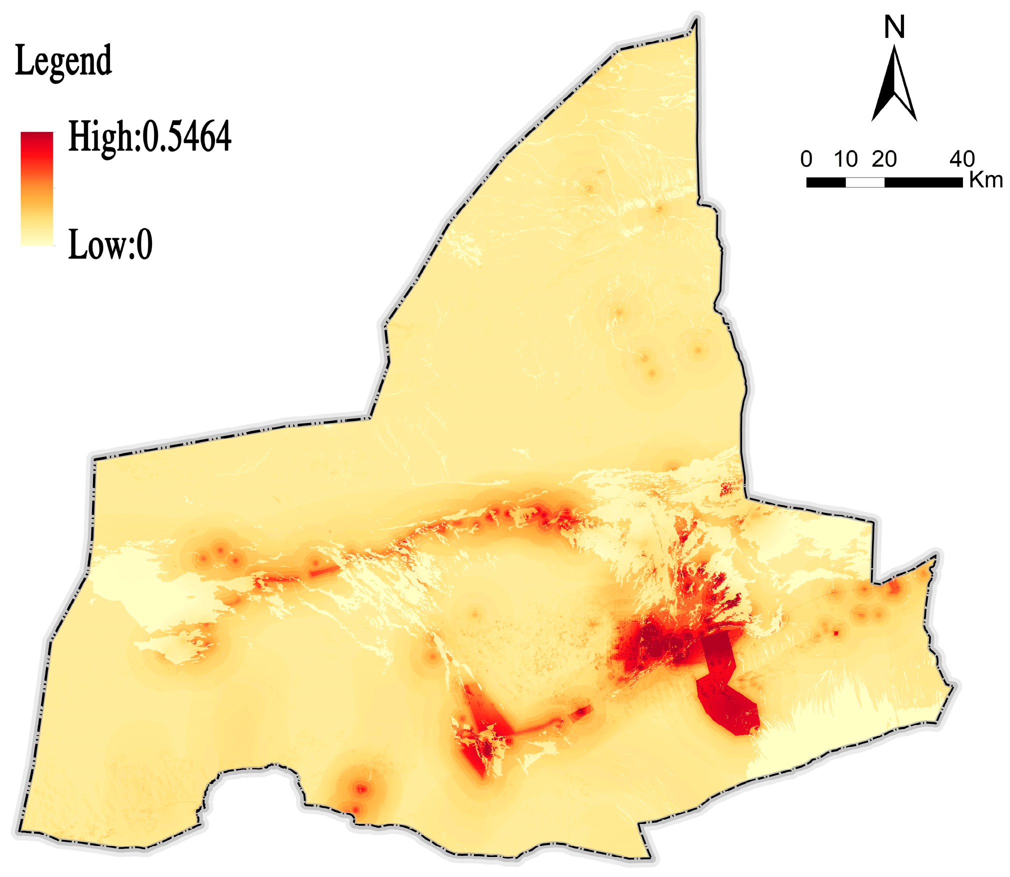
By refining the key information of the factors of the cultural heritage space in Dunhuang City, and by combining the actual conservation, preservation, management, and utilization of these factors, we can judge the importance of conservation and the feasibility of the utilization of each factor of the cultural heritage space. From the analysis of the superposition of cultural heritage, mountain and water systems, and landform landscape, the conservation value and foundation of the front area of the Qilian Mountains and the middle reaches of the Danghe River, where cultural heritage is concentrated, are high. Meanwhile, owing to the existence of water, the utilization value and foundation along the Dang River and Shule River are more prominent. From the analysis of the composition of the cultural heritage of trade routes, military defense communications, and historical identification information, we found that existing sites, such as the ancient Silk Road, the Great Wall, and the Xuanquanzhi, are provided with high conservation value and foundation. In contrast, ancient roads, the Great Wall, and the post-traffic stations that have died out but appear in historical records, poems, and cultural notes are of high utilization value. Particularly in the construction of the Great Wall and the National Cultural Park, the Great Wall defense system and supporting facilities for transportation and post-traffic stations are of high utilization expectations. According to the analysis of the conserved zones of the Dunhuang Grottoes, the conservation scope has higher conservation value and foundation. By contrast, the peripheral construction control area has more value and foundation for development and utilization. Regarding intangible cultural heritage and traditional folk culture, the oasis area bears the chief functions of inheriting, spreading, and displaying these cultures. Its conservation value and foundation are high. Meanwhile, there are high expectations for a cultural scene reproduction in the oasis area of human settlements in Dunhuang. On this basis, we evaluate the protection or utilization index of each element by expert scoring in turn, and we determine the weight by AHP to calculate the evaluation score of the factor. The analysis results of the data space of each factor can be derived through the publicity of 1 and 2, which embodies the evaluation level of protection and the utilization of each factor (see
Figure 5,
Table 2).
Next, we calculated the results of the suitability evaluation of the conservation and utilization of the factors of the Dunhuang region cultural heritage space using the field strength model (publicity 3 and 4; see
Figure 6 and
Figure 7). Conservation and utilization can be classified into the first-class corridor or partition, which is significant for conservation or utilization, and the second-class corridor or partition, which is generally significant for conservation or utilization. From this, the conservation space of cultural heritage is the representative symbol of the historical space in different periods. It is not connected in space and takes on a fragmented status, with a small part of it showing local partitions or corridors, whereas most of it is in tiny scattered patches. In combination with the evaluation process of sub-factors, the spatial differentiation features of Dunhuang’s cultural factors are obvious. These patches themselves usually carry obvious types of themes, such as the Great Wall military defense and its environment, grottoes and their environment, etc., thereby forming the characteristics of the organization of the cultural heritage space. Moreover, the utilization space of cultural heritage is characterized by a certain continuity. This can supplement and expand the overall historical network structure, taking on a superposition phenomenon with the conserved space, or it can be manifested by a further extension on the basis of the conserved space, thus forming the cross-domain linear features of the ancient Silk Road, the Great Wall, and other factors. It can be seen from this that only with the utilization space can the formation of the pattern of linear heritage settlements be promoted. The tourism service industry, leisure agriculture and forestry, ecological construction, etc., can be appropriately developed according to the local conditions.
4. Network Construction of Conservation and Utilization of the Cultural Heritage Space
Based on the suitability evaluation of the conservation and utilization above, it can be concluded that the space for the conservation and utilization of cultural heritage in Dunhuang is neither a simple corridor nor a patch or partition of unconnected links. Rather, it is a spatial network shaped by the combination of closely linked corridors and patches for conservation and utilization.
We hold that there are three features of this network in Dunhuang: overlapping at the same level, the combination of primary and secondary spaces, and significant differentiation. First, the overlapping at the same level involves a complex network of the same level of conservation space and utilization space with overlapping partitions or corridors. This is characterized by “One level and the same level” (such as the Dunhuang historic district) or “The second level is the same as the second level” (such as the contact space between Dunhuang district and Yangguan). Here, the conflict between conservation and utilization is obvious. We cannot simply consider conservation or simply achieve utilization. The proportion of conservation and utilization varies with the concrete types of cultural heritage. Second, the combination of primary and secondary spaces covers the conservation and utilization network with conservation as the main body (such as the sites of Xuanquanzhi and its surrounding spaces), and the conservation and utilization network with utilization as the main body (such as the contact space from Yangguan to the sites of Yumenguan). This is characterized by the conservation or utilization of the main factors, while the utilization or conservation of other corresponding factors is relatively secondary. Third, significant differentiation is obvious in the conservation or utilization of the area. This is reflected by the dominant network of conservation or utilization. For example, the environmental corridor along the central Duwei section of the Great Wall of the Han Dynasty, where the Dang River and Shule River meet, is mainly subject to utilization, taking into account the conservation factors.
Combined with the network types above, we can also construct a diagram of the network, which shows the integral conservation and utilization of the cultural heritage space in Dunhuang city (see
Figure 8). On the one hand, the network is a collage of patches and a series of connections. This collage of patches principally refers to the mutual collage of primary and secondary protective patches, while the possibility of a collage of utility patches is small. These collage patches are closely attached to the conservation and utilization corridors. The series of connections refers to the conservation and utilization corridors, conservation corridors, and utilization corridors and their connections to each other. The main corridors in Dunhuang are not made up of either conservation or utilization, but shaped by block combinations. For example, Yumen Duwei along the Great Wall of the Han Dynasty is mainly a first-class conservation and utilization corridor. Central Duwei is connected in series on its east side, and it is mainly a first-class utilization corridor. These embody the accumulation of the cultural space of the Great Wall of the Han Dynasty, as well as the natural constraints and utilization of oases, water systems, etc. They contribute to the formation of the cultural exhibition belt of the Great Wall of the Han Dynasty in series, and to the construction of the national cultural park system of the Great Wall of the Han Dynasty [
39]. On the other hand, a network of grid patterns and branched extensions takes shape, in which grid patterns are horizontally connected by the corridor of the Great Wall of the Han Dynasty, the National Cultural Park in the north, and the postal road corridor of Guasha Road and post-traffic system in the south. It is vertically connected by the Yangguan Duwei Corridor and the cultural ecological corridor of the Danghe River in the southern road of the western regions (from Yangguan to Yumenguan). This forms a “Two horizontal and two vertical”-shaped network. Moreover, block-like patches are shaped at the local node of “Two horizontal and two vertical”, which is inseparable from the corridor. A patch that is “block”-shaped forms, owing to the partition of the corridor. Branched extensions are principally distributed in the low mountainous areas in the south, with a certain extension along the river valley. For instance, the branched corridor of the Mogao Grottoes extends to the upper reaches of the Daquan River for exhibition and sightseeing. This is helpful to the integral conservation, zonal display, and node utilization of this cultural heritage.
The grid organization above shows that the conservation patches of the Dunhuang cultural heritage are collage-like, rather than having a simple concentric structure. That is, the importance of heritage conservation decreases from the center to the periphery. Furthermore, heritage corridors are shaped by connecting conservation and utilization in series, instead of the central line of the corridor being the conservation space and the periphery being the utilization space. Hence, only by constructing a reasonable utilization space can the conservation spaces be fully linked. Furthermore, patches and corridors are nested within each other, rather than separated from each other. These features are subject to the flow direction of water systems and water distribution, and are determined by the constraints of the natural environment pattern of mountains, oases, and the desert. The network embodies a matrix of oasis landscape ecology. These features reproduce the composition and essence of regional culture, as well as the cultural lifeblood of the ancient Silk Road system and the Great Wall military defense system as a whole. They demonstrate the coupling of cultural and social ideology with the natural environment. Hence, the conservation and utilization of Dunhuang’s cultural heritage space should enhance the organic management of landscapes, forests, lakes, and grassland. The space should include historical and cultural landscape restoration and the sustainable development of Dunhuang’s cultural space. This can be achieved by combining site conservation with ecological conservation, environmental utilization, and ecological restoration.
5. Conclusions and Discussion
By paving the way for the research on networks of integral conservation and utilization of cultural heritage spaces, this paper considered Dunhuang as a case study and evaluated the suitability of the conservation and utilization of its constituent factors. We developed a two-way index of conservation and utilization for this evaluation. The index can be used to assess the conservation and utilization of cultural heritage, given the differences and connections in the respective aims of conservation and utilization. In this process, the field strength model illustrates the suitability features of conservation and utilization. We found that the conservation and utilization space of Dunhuang’s cultural heritage is presented in three network characteristics: overlapping at the same level, the combination of primary and secondary spaces, and significant differentiation. Dunhuang formed an organization network of “patch collage and corridor concatenation” and the network formed a “mine field pattern and branch extension”. The cultural heritage space is a product of its natural and humanistic environments, and these environments are the conditions for the conservation and utilization of the cultural heritage space.
In the overall network environment of land space, the relationship between three districts and three lines, the patterns of land space conservation and utilization, and the conservation and utilization of cultural heritage need to be further connected. With strict constraints on ecological space, production space, and living space, a network of conservation and utilization for cultural heritage spaces can be helpful in guiding the construction of regional cultural functions and for selecting cultural products. The results of our study can guide the conservation, activation, and utilization of cultural resources from the overall level of the city, and help facilitate the management of cultural heritage spaces.
With the development of social networking at this stage, the traditional and simplified heritage management model is facing unprecedented challenges. In this context, the space conservation and utilization network of cultural heritage should promote the development of regional cultural heritage management and control. At the regional level, it is necessary to ensure the bottom line of cultural safety, life safety, conservation safety and ecological safety, highlight the overall spatial pattern and basic cultural development characteristics of culture, highlight the advantages and characteristics of cultural heritage, promote the inheritance of high-quality cultural heritage, improve social quality, and develop economic capacity. By coordinating and empowering regional cultural resources, the cultural landscape pattern is presented in the form of cultural space (i.e., combination of cultural resources and cultural ecology and its spatial form) in the historical environment gathering area and corridor of cultural heritage, reflecting the overall spatial control. It is worth discussing that on the basis of the above regional level, a detailed level guidance is also needed. Based on the composition of cultural heritage inside and outside the area, the cultural space unit structure of historical environmental conservation and utilization should be sorted out to reflect the implementation of the project.


