Analysis of Detailed Lake Variations and Associated Hydrologic Driving Factors in a Semi-Arid Ungauged Closed Watershed
Abstract
:1. Introduction
2. Materials and Methods
2.1. Study Area
2.2. Research Approach
2.3. Hydrologic Modeling
2.4. Data Collected
2.4.1. Input Data
2.4.2. Evaluation Data
2.5. Model Setup and Performance Evaluation
2.6. Analyses of Lake Variation and Impact Factors
3. Results
3.1. Evaluation of Model Performance
3.2. Hydrologic Process Analysis
3.3. Correlation Analysis
4. Discussion
4.1. Criteria and Results of Model Evaluation
4.2. Comparison with Previous Studies
4.3. Guidance for Local Water Management
4.4. Limitations and Future Work
5. Conclusions
Author Contributions
Funding
Institutional Review Board Statement
Informed Consent Statement
Data Availability Statement
Conflicts of Interest
References
- Fu, C.; Wu, H.; Zhu, Z.; Song, C.; Xue, B.; Wu, H.; Ji, Z.; Dong, L. Exploring the potential factors on the striking water level variation of the two largest semi-arid-region lakes in northeastern Asia. Catena 2022, 1198, 105037. [Google Scholar] [CrossRef]
- Wurtsbaugh, W.A.; Miller, C.; Null, S.E.; DeRose, J.; Wilcock, P.; Hahnenberger, M.; Howe, F.; Moore, J. Decline of the world’s saline lakes. Nat. Geosci. 2017, 10, 816–823. [Google Scholar] [CrossRef]
- Chen, J.; Qian, H.; Gao, Y.; Wang, H.; Zhang, M. Insights into hydrological and hydrochemical processes in response to water replenishment for lakes in arid regions. J. Hydrol. 2020, 581, 124386. [Google Scholar] [CrossRef]
- Janssen, A.B.; Van Wijk, D.; Van Gerven, L.P.; Bakker, E.S.; Brederveld, R.J.; DeAngelis, D.L.; Janse, J.H.; Mooij, W.M. Success of lake restoration depends on spatial aspects of nutrient loading and hydrology. Sci. Total Environ. 2019, 679, 248–259. [Google Scholar] [CrossRef] [PubMed]
- Tan, C.; Guo, B.; Kuang, H.; Yang, H.; Ma, M. Lake area changes and their influence on factors in arid and semi-arid regions along the silk road. Remote Sens. 2018, 10, 595. [Google Scholar] [CrossRef] [Green Version]
- Murumkar, A.; Durand, M.; Fernández, A.; Moritz, M.; Mark, B.; Phang, S.C.; Laborde, S.; Scholte, P.; Shastry, A.; Hamilton, I. Trends and spatial patterns of 20th century temperature, rainfall and PET in the semi-arid Logone River basin, Sub-Saharan Africa. J. Arid Environ. 2020, 178, 104168. [Google Scholar] [CrossRef]
- Yan, X.; Liu, J.; Rühland, K.M.; Smol, J.P.; Chen, F. Climate change as the dominant driver of recent ecological changes in a semi-arid alpine lake from the Chinese Loess Plateau. J. Paleolimnol. 2022, 68, 39–57. [Google Scholar] [CrossRef]
- Jeppesen, E.; Beklioğlu, M.; Özkan, K.; Akyürek, Z. Salinization increase due to climate change will have substantial negative effects on inland waters: A call for multifaceted research at the local and global scale. Innovation 2020, 1, 100030. [Google Scholar] [CrossRef]
- Cooley, S.W.; Ryan, J.C.; Smith, L.C. Human alteration of global surface water storage variability. Nature 2021, 591, 78–81. [Google Scholar] [CrossRef]
- Zhang, Y.; Liang, W.; Liao, Z.; Han, Z.; Xu, X.; Jiao, R.; Liu, H. Effects of climate change on lake area and vegetation cover over the past 55 years in Northeast Inner Mongolia grassland, China. Theor. Appl. Climatol. 2019, 138, 13–25. [Google Scholar] [CrossRef]
- Wang, J.; Ding, J.; Li, G.; Liang, J.; Yu, D.; Aishan, T.; Zhang, F.; Yang, J.; Abulimiti, A.; Liu, J. Dynamic detection of water surface area of Ebinur Lake using multi-source satellite data (Landsat and Sentinel-1A) and its responses to changing environment. Catena 2019, 177, 189–201. [Google Scholar] [CrossRef]
- Wufu, A.; Wang, H.; Chen, Y.; Rusuli, Y.; Ma, L.; Yang, S.; Zhang, F.; Wang, D.; Li, Q.; Li, Y. Lake water volume fluctuations in response to climate change in Xinjiang, China from 2002 to 2018. PeerJ 2020, 8, 9683. [Google Scholar] [CrossRef] [PubMed]
- Gxokwe, S.; Dube, T.; Mazvimavi, D. Multispectral remote sensing of wetlands in semi-arid and arid areas: A review on applications, challenges and possible future research directions. Remote Sens. 2020, 12, 4190. [Google Scholar] [CrossRef]
- Zhang, Y.; Zhang, Y.; Shi, K.; Zhou, Y.; Li, N. Remote sensing estimation of water clarity for various lakes in China. Water Res. 2021, 192, 116844. [Google Scholar] [CrossRef]
- Huovinen, P.; Ramírez, J.; Caputo, L.; Gómez, I. Mapping of spatial and temporal variation of water characteristics through satellite remote sensing in Lake Panguipulli, Chile. Sci. Total Environ. 2019, 679, 196–208. [Google Scholar] [CrossRef]
- Wan, W.; Xiao, P.; Feng, X.; Li, H.; Ma, R.; Duan, H.; Zhao, L. Monitoring lake changes of Qinghai-Tibetan Plateau over the past 30 years using satellite remote sensing data. Chin. Sci. Bull. 2014, 59, 1021–1035. [Google Scholar] [CrossRef]
- Tulbure, M.G.; Broich, M.; Stehman, S.V.; Kommareddy, A. Surface water extent dynamics from three decades of seasonally continuous Landsat time series at subcontinental scale in a semi-arid region. Remote Sens. Environ. 2016, 178, 142–157. [Google Scholar] [CrossRef]
- Dang, A.T.; Kumar, L.; Reid, M.; Nguyen, H. Remote sensing approach for monitoring coastal wetland in the Mekong Delta, Vietnam: Change trends and their driving forces. Remote Sens. 2021, 13, 3359. [Google Scholar] [CrossRef]
- Hooker, J.; Duveiller, G.; Cescatti, A. Data descriptor: A global dataset of air temperature derived from satellite remote sensing and weather stations. Sci. Data 2018, 5, 180246. [Google Scholar] [CrossRef] [Green Version]
- Courty, L.G.; Soriano-Monzalvo, J.C.; Pedrozo-Acuña, A. Evaluation of open-access global digital elevation models (AW3D30, SRTM, and ASTER) for flood modelling purposes. J. Flood Risk Manag. 2019, 12, 12550. [Google Scholar] [CrossRef] [Green Version]
- Huang, Q.; Long, D.; Du, M.; Zeng, C.; Li, X.; Hou, A.; Hong, Y. An improved approach to monitoring Brahmaputra River water levels using retracked altimetry data. Remote Sens. Environ. 2018, 211, 112–128. [Google Scholar] [CrossRef]
- Shrestha, N.K.; Qamer, F.M.; Pedreros, D.; Murthy, M.S.R.; Wahid, S.M.; Shrestha, M. Evaluating the accuracy of Climate Hazard Group (CHG) satellite rainfall estimates for precipitation based drought monitoring in Koshi basin, Nepal. J. Hydrol. 2017, 13, 138–151. [Google Scholar] [CrossRef]
- Wilson, A.M.; Jetz, W. Remotely sensed high-resolution global cloud dynamics for predicting ecosystem and biodiversity distributions. PLoS Biol. 2016, 14, 1002415. [Google Scholar] [CrossRef] [PubMed]
- Wang, T.; Shi, J.; Husi, L.; Zhao, T.; Ji, D.; Xiong, C.; Gao, B. Effect of solar-cloud-satellite geometry on land surface shortwave radiation derived from remotely sensed data. Remote Sens. 2017, 9, 690. [Google Scholar] [CrossRef] [Green Version]
- Pandi, D.; Kothandaraman, S.; Kuppusamy, M. Hydrological models: A review. Int. J. Hydrol. Sci. Technol. 2021, 12, 223–242. [Google Scholar] [CrossRef]
- Tahmasebi Nasab, M.; Singh, V.; Chu, X. SWAT modeling for depression-dominated areas: How do depressions manipulate hydrologic modeling? Water 2017, 9, 58. [Google Scholar] [CrossRef] [Green Version]
- Zeng, L.; Chu, X. A new probability-embodied model for simulating variable contributing areas and hydrologic processes dominated by surface depressions. J. Hydrol. 2021, 602, 126762. [Google Scholar] [CrossRef]
- Liang, K. Quantifying streamflow variations in ungauged lake basins by integrating remote sensing and water balance modeling: A case study of the erdos larus relictus national nature reserve, China. Remote Sens. 2017, 9, 588. [Google Scholar] [CrossRef] [Green Version]
- Yang, X.; Lu, X.; Park, E.; Tarolli, P. Impacts of climate change on lake fluctuations in the Hindu Kush-Himalaya-Tibetan Plateau. Remote Sens. 2019, 11, 1082. [Google Scholar] [CrossRef] [Green Version]
- Yue, H.; Liu, Y. Water balance and influence mechanism analysis: A case study of Hongjiannao Lake, China. Environ. Monit. Assess. 2021, 193, 219. [Google Scholar] [CrossRef]
- Ala-Aho, P.; Rossi, P.M.; Isokangas, E.; Kløve, B. Fully integrated surface–subsurface flow modelling of groundwater–lake interaction in an esker aquifer: Model verification with stable isotopes and airborne thermal imaging. J. Hydrol. 2015, 522, 391–406. [Google Scholar] [CrossRef]
- Adnan, M.; Kang, S.; Zhang, G.; Saifullah, M.; Anjum, M.N.; Ali, A.F. Simulation and analysis of the water balance of the Nam Co Lake using SWAT model. Water 2019, 11, 1383. [Google Scholar] [CrossRef] [Green Version]
- Zeng, L.; Shao, J.; Chu, X. Improved hydrologic modeling for depression-dominated areas. J. Hydrol. 2020, 590, 125269. [Google Scholar] [CrossRef]
- Bhattacharjee, J.; Rabbil, M.; Fazel, N.; Darabi, H.; Choubin, B.; Khan, M.M.R.; Marttila, H.; Haghighi, A.T. Accuracy assessment of remotely sensed data to analyze lake water balance in semi-arid region. Sci. Total Environ. 2021, 797, 149034. [Google Scholar] [CrossRef] [PubMed]
- Moknatian, M.; Piasecki, M. Development of predictive models for water budget simulations of closed-basin lakes: Case studies of Lakes Azuei and Enriquillo on the Island of Hispaniola. Hydrology 2021, 8, 148. [Google Scholar] [CrossRef]
- Lu, J.; Chen, X.; Zhang, L.; Sauvage, S.; Sánchez-Pérez, J.M. Water balance assessment of an ungauged area in Poyang Lake watershed using a spatially distributed runoff coefficient model. J. Hydroinform. 2018, 20, 1009–1024. [Google Scholar] [CrossRef]
- Li, Z.; Lei, X.; Liao, W.; Yang, Q.; Cai, S.; Wang, X.; Wang, C.; Wang, J. Lake inflow simulation using the coupled water balance method and Xin’anjiang Model in an ungauged stream of Chaohu Lake Basin, China. Front. Earth Sci. 2021, 9, 615692. [Google Scholar] [CrossRef]
- Garavaglia, F.; Le Lay, M.; Gottardi, F.; Garçon, R.; Gailhard, J.; Paquet, E.; Mathevet, T. Impact of model structure on flow simulation and hydrological realism: From a lumped to a semi-distributed approach. Hydrol. Earth Syst. Sci. 2017, 21, 3937–3952. [Google Scholar] [CrossRef] [Green Version]
- Das, T.; Bárdossy, A.; Zehe, E.; He, Y. Comparison of conceptual model performance using different representations of spatial variability. J. Hydrol. 2008, 356, 106–118. [Google Scholar] [CrossRef]
- López López, P.; Sutanudjaja, E.H.; Schellekens, J.; Sterk, G.; Bierkens, M.F. Calibration of a large-scale hydrological model using satellite-based soil moisture and evapotranspiration products. Hydrol. Earth Syst. Sci. 2017, 21, 3125–3144. [Google Scholar] [CrossRef] [Green Version]
- Sirisena, T.J.G.; Maskey, S.; Ranasinghe, R. Hydrological model calibration with streamflow and remote sensing based evapotranspiration data in a data poor basin. Remote Sens. 2020, 12, 3768. [Google Scholar] [CrossRef]
- Pan, S.; Xu, Y.P.; Gu, H.; Yu, B.; Xuan, W. Evaluation of Remote Sensing-Based Evapotranspiration Datasets for Improving Hydrological Model Simulation in Humid Region of East China. Remote Sens. 2022, 14, 4546. [Google Scholar] [CrossRef]
- Ha, L.T.; Bastiaanssen, W.G.; Van Griensven, A.; Van Dijk, A.I.; Senay, G.B. Calibration of spatially distributed hydrological processes and model parameters in SWAT using remote sensing data and an auto-calibration procedure: A case study in a Vietnamese river basin. Water 2018, 10, 212. [Google Scholar] [CrossRef] [Green Version]
- Bennour, A.; Jia, L.; Menenti, M.; Zheng, C.; Zeng, Y.; Asenso Barnieh, B.; Jiang, M. Calibration and validation of SWAT model by using hydrological remote sensing observables in the Lake Chad Basin. Remote Sens. 2022, 14, 1511. [Google Scholar] [CrossRef]
- Yue, H.; Li, Y.; Qian, J.; Liu, Y. A new accuracy evaluation method for water body extraction. Int. J. Remote Sens. 2020, 41, 7311–7342. [Google Scholar] [CrossRef]
- Cao, H.; Han, L.; Liu, Z.; Li, L. Monitoring and driving force analysis of spatial and temporal change of water area of Hongjiannao Lake from 1973 to 2019. Ecol. Inform. 2021, 61, 101230. [Google Scholar] [CrossRef]
- Wang, N.; Chu, X. A new algorithm for delineation of surface depressions and channels. Water 2019, 12, 7. [Google Scholar] [CrossRef] [Green Version]
- Wang, N.; Chu, X.; Zhang, X. Functionalities of surface depressions in runoff routing and hydrologic connectivity modeling. J. Hydrol. 2021, 593, 125870. [Google Scholar] [CrossRef]
- He, J.; Yang, K.; Tang, W.; Lu, H.; Qin, J.; Chen, Y.Y.; Li, X. The first high-resolution meteorological forcing dataset for land process studies over China. Sci. Data 2020, 7, 25. [Google Scholar] [CrossRef] [PubMed] [Green Version]
- Liang, S.; Zhao, X.; Yuan, W.; Liu, S.; Cheng, X.; Xiao, Z.; Zhang, X.; Liu, Q.; Cheng, J.; Tang, H.; et al. A Long-term Global LAnd Surface Satellite (GLASS) Dataset for Environmental Studies. Int. J. Digit. Earth 2013, 6, 5–33. [Google Scholar] [CrossRef]
- Hargreaves, G.H.; Samani, Z.A. Estimating potential evapotranspiration. J. Irrig. Drain. Div. 1982, 108, 225–230. [Google Scholar] [CrossRef]
- Jaafar, H.H.; Ahmad, F.A.; El Beyrouthy, N. GCN250, new global gridded curve numbers for hydrologic modeling and design. Sci. Data 2019, 6, 145. [Google Scholar] [CrossRef] [Green Version]
- Saxton, K.E.; Rawls, W.; Romberger, J.S.; Papendick, R.I. Estimating generalized soil-water characteristics from texture. Soil Sci. Soc. Am. J. 1986, 50, 1031–1036. [Google Scholar] [CrossRef]
- Fischer, G.; Nachtergaele, F.; Prieler, S.; Van Velthuizen, H.T.; Verelst, L.; Wiberg, D. Global Agro-Ecological Zones Assessment for Agriculture (GAEZ 2008); Austria and FAO: Rome, Italy, 2008; p. 10. [Google Scholar]
- Yang, Z.Y.; Wang, K.; Yuan, Y.; Huang, J.; Chen, Z.J.; Li, C. Non-negligible lag of groundwater infiltration recharge: A case in Mu Us Sandy Land, China. Water 2019, 11, 561. [Google Scholar] [CrossRef] [Green Version]
- Lu, J.; Wang, G.; Chen, T.; Li, S.; Hagan, D.F.T.; Kattel, G.; Peng, J.; Jiang, T.; Su, B. A harmonized global land evaporation dataset from model-based products covering 1980–2017. Earth Syst. Sci. Data 2021, 13, 5879–5898. [Google Scholar] [CrossRef]
- McFeeters, S.K. The use of the Normalized Difference Water Index (NDWI) in the delineation of open water features. Int. J. Remote Sens. 1996, 17, 1425–1432. [Google Scholar] [CrossRef]
- Yang, L. Research on Comprehensive Regulation of Water Resources in Arid Inland River Basin from Ecological Perspective-with Hongjiannao Basin as the Study Objective. Ph.D. Dissertation, Xi’an University of Technology, Xi’an, China, 2014. (In Chinese). [Google Scholar]
- Lenhart, T.; Eckhardt, K.; Fohrer, N.; Frede, H.G. Comparison of two different approaches of sensitivity analysis. Phys. Chem. Earth 2002, 27, 645–654. [Google Scholar] [CrossRef]
- Ficklin, D.L.; Luo, Y.; Stewart, I.T.; Maurer, E.P. Development and application of a hydroclimatological stream temperature model within the Soil and Water Assessment Tool. Water Resour. Res. 2012, 48, W01511. [Google Scholar] [CrossRef] [Green Version]
- Moriasi, D.N.; Arnold, J.G.; Van Liew, M.W.; Bingner, R.L.; Harmel, R.D.; Veith, T.L. Model evaluation guidelines for systematic quantification of accuracy in watershed simulations. Trans. ASABE 2007, 50, 885–900. [Google Scholar] [CrossRef]
- Shahidian, S.; Serralheiro, R.; Serrano, J.; Teixeira, J.; Haie, N.; Santos, F. Hargreaves and Other Reduced-Set Methods for Calculating Evapotranspiration; IntechOpen: London, UK, 2012; pp. 59–80. [Google Scholar]
- Dan, Z.; Bo, Z. Effect of potential evapotranspiration estimation method on reconnaissance drought index (RDI) calculation. Chin. J. Agrometeorol. 2014, 35, 258. [Google Scholar]
- Xia, X.; Zhu, X.; Pan, Y.; Zhang, J. Hargreaves ET0 Equation Regression Correction and Parameter Spatialization for Mainland China. Appl. Eng. Agric. 2020, 36, 673–686. [Google Scholar] [CrossRef]
- Jin, X.; He, C.; Zhang, L.; Zhang, B. A modified groundwater module in SWAT for improved streamflow simulation in a large, arid endorheic river watershed in Northwest China. Chin. Geogr. Sci. 2018, 28, 47–60. [Google Scholar] [CrossRef] [Green Version]
- Shao, G.; Zhang, D.; Guan, Y.; Xie, Y.; Huang, F. Application of SWAT model with a modified groundwater module to the semi-arid Hailiutu River Catchment, Northwest China. Sustainability 2019, 11, 2031. [Google Scholar] [CrossRef] [Green Version]
- Geng, X.; Zhang, C.; Zhang, F.E.; Chen, Z.; Nie, Z.; Liu, M. Hydrological modeling of karst watershed containing subterranean river using a modified SWAT model: A case study of the Daotian River Basin, southwest China. Water 2021, 13, 3552. [Google Scholar] [CrossRef]
- Liang, K.; Yan, G. Application of landsat imagery to investigate lake area variations and relict gull habitat in hongjian lake, Ordos Plateau, China. Remote Sens. 2017, 9, 1019. [Google Scholar] [CrossRef] [Green Version]
- Liang, K.; Li, Y. Changes in lake area in response to climatic forcing in the endorheic Hongjian Lake Basin, China. Remote Sens. 2019, 11, 3046. [Google Scholar] [CrossRef] [Green Version]
- Yue, H.; Liu, Y. Variations in the lake area, water level, and water volume of Hongjiannao Lake during 1986–2018 based on Landsat and ASTER GDEM data. Environ. Monit. Assess. 2019, 191, 606. [Google Scholar] [CrossRef]
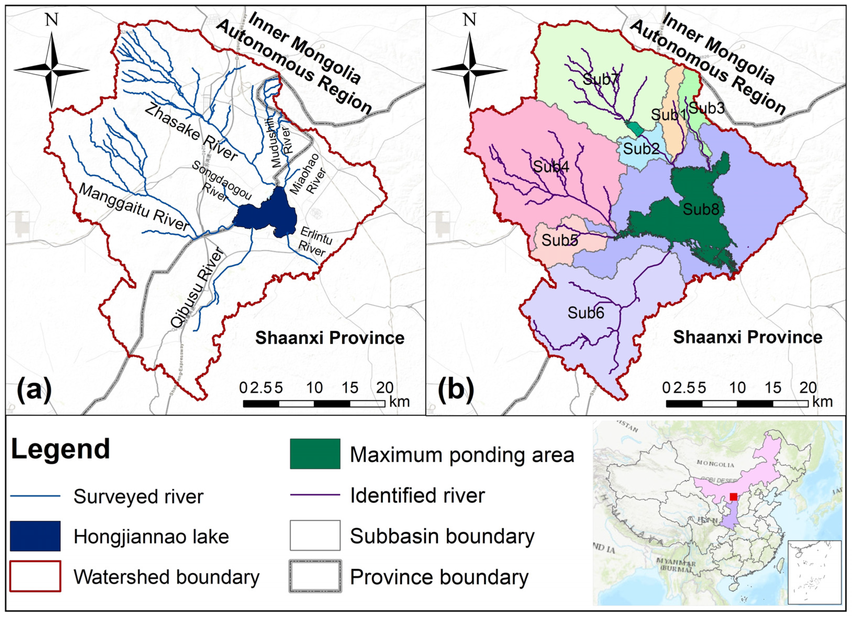

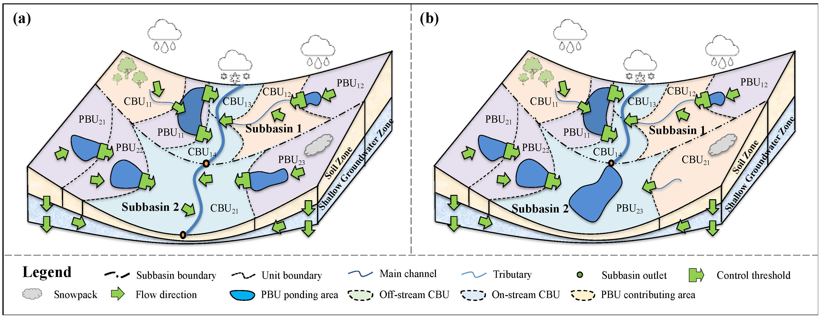
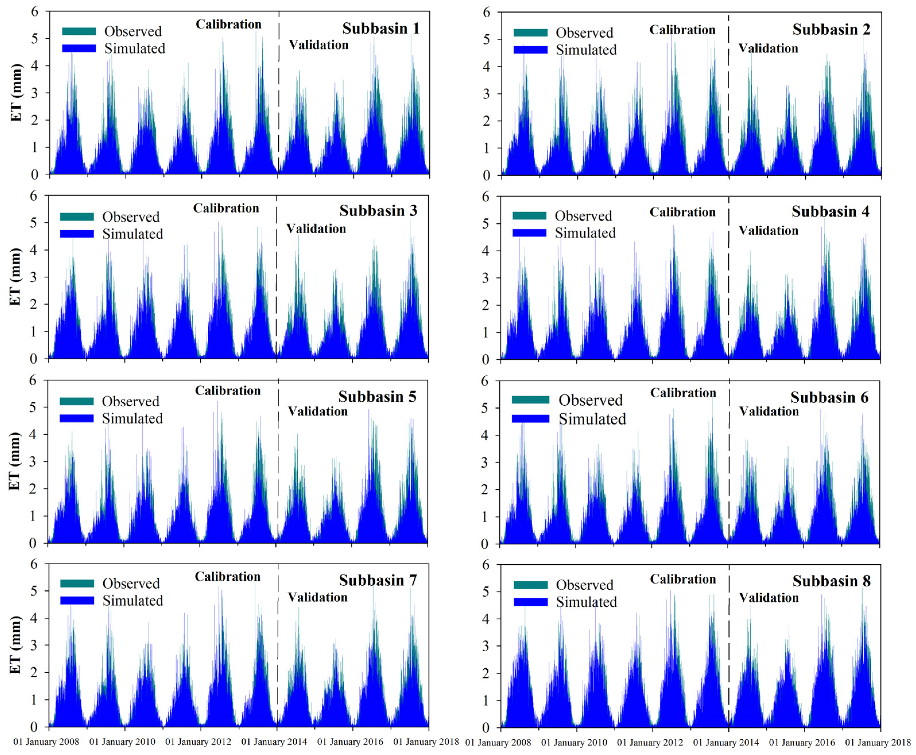


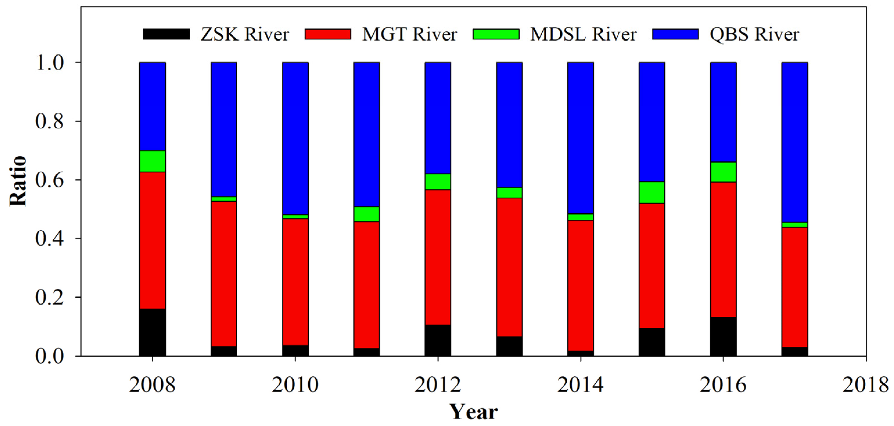
| Zone Name | Hydrologic Processes |
|---|---|
| Canopy zone | 1. Interception 2. Evaporation |
| Snow zone | 1. Snow storage 2. Snow melt 3. Sublimination |
| Surface zone | 1. Surface runoff, infiltration, and runoff routing in CA 2. Percolation, evaporation, and runoff routing in PA 3. Variations of PA and its storage |
| Upper soil zone | 1. Soil temperature 2. Soil ET 3. Soil water content 4. Percolation to lower soil zone |
| Lower soil zone | 1. Percolation to groundwater zone |
| Shallow groundwater zone | 1. Percolation to deep groundwater zone 2. Discharge to main channels or lakes |
| Input Data | Source | Type |
|---|---|---|
| Topographic data | https://www.eorc.jaxa.jp/ALOS/en/dataset/aw3d30/aw3d30_e.htm (accessed on 16 May 2022) | Raster (30 m) |
| Precipitation | http://data.tpdc.ac.cn/en/data/8028b944-daaa-4511-8769-965612652c49/ (accessed on 27 July 2022) | Raster (0.1°) |
| Air temperature | http://www.glass.umd.edu/Download.html (accessed on 23 July 2022) | Raster (250 m) |
| Leaf area index | http://www.glass.umd.edu/Download.html (accessed on 23 July 2022) | Raster (250 m) |
| SCS curve number | https://figshare.com/articles/dataset/GCN250_global_curve_number_datasets_for_hydrologic_modeling_and_design/7756202 (accessed on 29 July 2022) | Raster (250 m) |
| Soil data | https://www.fao.org/soils-portal/data-hub/soil-maps-and-databases/harmonized-world-soil-database-v12/en/ (accessed on 11 August 2022) | Raster (1 km) |
| Date | Area (km2) | Date | Area (km2) | Date | Area (km2) |
|---|---|---|---|---|---|
| 24 April 2008 | 40.16 | 24 September 2011 | 34.26 | 1 July 2015 | 31.40 |
| 10 May 2008 | 39.98 | 3 April 2013 | 34.27 | 24 December 2015 | 30.72 |
| 15 September 2008 | 38.76 | 9 June 2013 | 32.73 | 9 January 2016 | 30.98 |
| 1 October 2008 | 39.35 | 29 September 2013 | 33.02 | 29 March 2016 | 31.87 |
| 21 January 2009 | 38.84 | 16 November 2013 | 32.89 | 16 May 2016 | 30.94 |
| 24 April 2009 | 39.73 | 18 December 2013 | 32.91 | 17 June 2016 | 30.62 |
| 29 May 2009 | 38.72 | 3 January 2014 | 32.80 | 21 September 2016 | 34.03 |
| 30 June 2009 | 38.05 | 20 February 2014 | 32.70 | 8 November 2016 | 35.32 |
| 20 October 2009 | 37.82 | 27 May 2014 | 32.59 | 10 December 2016 | 35.97 |
| 24 January 2010 | 37.99 | 14 July 2014 | 31.81 | 11 January 2017 | 36.34 |
| 20 August 2010 | 35.93 | 15 August 2014 | 31.56 | 1 April 2017 | 36.08 |
| 8 November 2010 | 36.05 | 2 October 2014 | 31.97 | 19 May 2017 | 35.88 |
| 10 December 2010 | 35.75 | 21 December 2014 | 31.73 | 8 September 2017 | 34.52 |
| 27 January 2011 | 35.26 | 23 February 2015 | 31.96 | 26 October 2017 | 36.24 |
| 17 April 2011 | 36.15 | 11 March 2015 | 32.13 | - | - |
| 22 July 2011 | 34.88 | 28 April 2015 | 32.61 | - | - |
| Sub-Basin ID | Area (km2) | Natural Surface Runoff (104 m3) | Land Cover Change (104 m3) | Climate Change (104 m3) | Reservoir Construction (104 m3) | Domestic Usage (104 m3) | Actual Surface Runoff (104 m3) |
|---|---|---|---|---|---|---|---|
| 1 | 33.95 | 118.94 | 16.82 | 12.60 | 8.49 | 13.23 | 67.81 |
| 2 | 30.16 | 105.69 | 14.95 | 11.19 | 7.55 | 11.76 | 60.25 |
| 3 | 27.40 | 103.83 | 13.58 | 10.17 | 6.85 | 0.00 | 73.21 |
| 4 | 295.70 | 1031.42 | 146.56 | 109.73 | 73.97 | 217.58 | 483.61 |
| 5 | 48.90 | 170.55 | 24.23 | 18.14 | 12.23 | 35.98 | 79.97 |
| 6 | 267.83 | 1080.70 | 132.74 | 99.38 | 67.00 | 181.22 | 600.44 |
| 7 | 235.82 | 826.32 | 116.88 | 87.51 | 58.99 | 91.94 | 471.05 |
| 8 | 404.03 | 1698.14 | 200.25 | 149.92 | 101.07 | 199.17 | 1110.38 |
| Total | 1343.79 | 5135.59 | 666.01 | 498.64 | 336.16 | 750.89 | 2946.72 |
| Parameter | Descriptions | Calibration Range | Calibrated Value | Sensitivity Index (I) |
|---|---|---|---|---|
| Ccnp | Ratio of precipitation falling into canopy zone | 0–1 | 0.2 | −0.02 |
| C1et | Empirical evapotranspiration parameters | 0–1 | 0.1 | 0.02 |
| C2et | 0–1 | 0.1 | 0.05 | |
| C3et | ≥0 | 2.0 | −0.0001 | |
| Ceva | Lake evaporation coefficient | ≥0 | 1.9 | −1.06 |
| CN | Curve number | 0–100 | 65–74 | 1.16 |
| Ia | Initial abstraction | 0–1 | 0.3 | −0.19 |
| lagsur | Surface runoff lag coefficient | 0–24 | 0.6 | 0.004 |
| lagls | Soil percolation lag coefficient (days) | ≥0 | 15–50 days | −0.03 |
| Csgw | Shallow groundwater percolation coefficient | 0–1 | 0.19–0.85 | −0.50 |
| lagsgw | Shallow groundwater lag coefficient (days) | ≥0 | 10–200 days | −0.01 |
| Sub-Basin ID | Area | Reference Value | Simulated Value | Error | ||
|---|---|---|---|---|---|---|
| (km2) | (104 m3) | (mm) | (104 m3) | (mm) | (%) | |
| 1 | 33.95 | 67.81 | 19.98 | 73.10 | 21.53 | +7.81 |
| 2 | 30.16 | 60.25 | 19.98 | 66.06 | 21.90 | +9.64 |
| 3 | 27.40 | 73.21 | 26.72 | 74.77 | 27.29 | +2.13 |
| 4 | 295.70 | 483.61 | 16.35 | 458.03 | 15.49 | −5.29 |
| 5 | 48.90 | 79.97 | 16.35 | 81.98 | 16.77 | +2.52 |
| 6 | 267.83 | 600.44 | 22.42 | 601.05 | 22.44 | +0.10 |
| 7 | 235.82 | 471.05 | 19.98 | 472.82 | 20.05 | +0.37 |
| 8 | 404.03 | 1110.38 | 27.48 | 1005.48 | 24.89 | −9.45 |
| Year | Source | Sink | DS | ||||||||
|---|---|---|---|---|---|---|---|---|---|---|---|
| RSIN | CAIN | USIN | GWIN | EVA | |||||||
| mm | % | mm | % | mm | % | mm | % | mm | % | mm | |
| 2008 | 41.92 | 52.54 | 16.41 | 20.56 | 18.22 | 22.83 | 3.24 | 4.06 | 153.86 | 100.00 | −74.07 |
| 2009 | 24.91 | 43.26 | 5.73 | 9.94 | 14.24 | 24.72 | 12.71 | 22.08 | 144.63 | 100.00 | −87.04 |
| 2010 | 26.21 | 76.94 | 0.87 | 2.56 | 3.57 | 10.48 | 3.41 | 10.02 | 127.82 | 100.00 | −93.75 |
| 2011 | 24.84 | 95.25 | 0.18 | 0.68 | 0.50 | 1.93 | 0.56 | 2.13 | 118.05 | 100.00 | −91.98 |
| 2012 | 41.85 | 26.53 | 45.49 | 28.84 | 57.02 | 36.16 | 13.35 | 8.47 | 99.71 | 100.00 | 58.01 |
| 2013 | 32.16 | 23.21 | 25.87 | 18.67 | 50.58 | 36.50 | 29.95 | 21.62 | 126.69 | 100.00 | 11.87 |
| 2014 | 23.97 | 46.18 | 2.90 | 5.60 | 11.66 | 22.48 | 13.36 | 25.75 | 123.05 | 100.00 | −71.15 |
| 2015 | 23.82 | 39.97 | 14.51 | 24.36 | 18.66 | 31.32 | 2.59 | 4.35 | 112.76 | 100.00 | −53.17 |
| 2016 | 56.95 | 17.20 | 115.93 | 35.02 | 137.23 | 41.45 | 20.94 | 6.32 | 106.28 | 100.00 | 224.76 |
| 2017 | 36.34 | 21.17 | 19.93 | 11.61 | 57.71 | 33.61 | 57.71 | 33.61 | 139.95 | 100.00 | 31.73 |
Disclaimer/Publisher’s Note: The statements, opinions and data contained in all publications are solely those of the individual author(s) and contributor(s) and not of MDPI and/or the editor(s). MDPI and/or the editor(s) disclaim responsibility for any injury to people or property resulting from any ideas, methods, instructions or products referred to in the content. |
© 2023 by the authors. Licensee MDPI, Basel, Switzerland. This article is an open access article distributed under the terms and conditions of the Creative Commons Attribution (CC BY) license (https://creativecommons.org/licenses/by/4.0/).
Share and Cite
Wang, N.; Yang, J.; Zhang, Z.; Xiao, Y.; Wang, H.; He, J.; Yi, L. Analysis of Detailed Lake Variations and Associated Hydrologic Driving Factors in a Semi-Arid Ungauged Closed Watershed. Sustainability 2023, 15, 6535. https://doi.org/10.3390/su15086535
Wang N, Yang J, Zhang Z, Xiao Y, Wang H, He J, Yi L. Analysis of Detailed Lake Variations and Associated Hydrologic Driving Factors in a Semi-Arid Ungauged Closed Watershed. Sustainability. 2023; 15(8):6535. https://doi.org/10.3390/su15086535
Chicago/Turabian StyleWang, Ning, Jingbo Yang, Zaiyong Zhang, Yong Xiao, Hanbing Wang, Jinjun He, and Lingqi Yi. 2023. "Analysis of Detailed Lake Variations and Associated Hydrologic Driving Factors in a Semi-Arid Ungauged Closed Watershed" Sustainability 15, no. 8: 6535. https://doi.org/10.3390/su15086535
APA StyleWang, N., Yang, J., Zhang, Z., Xiao, Y., Wang, H., He, J., & Yi, L. (2023). Analysis of Detailed Lake Variations and Associated Hydrologic Driving Factors in a Semi-Arid Ungauged Closed Watershed. Sustainability, 15(8), 6535. https://doi.org/10.3390/su15086535


