Zagros Grass Index—A New Vegetation Index to Enhance Fire Fuel Mapping: A Case Study in the Zagros Mountains
Abstract
:1. Introduction
2. Materials and Methods
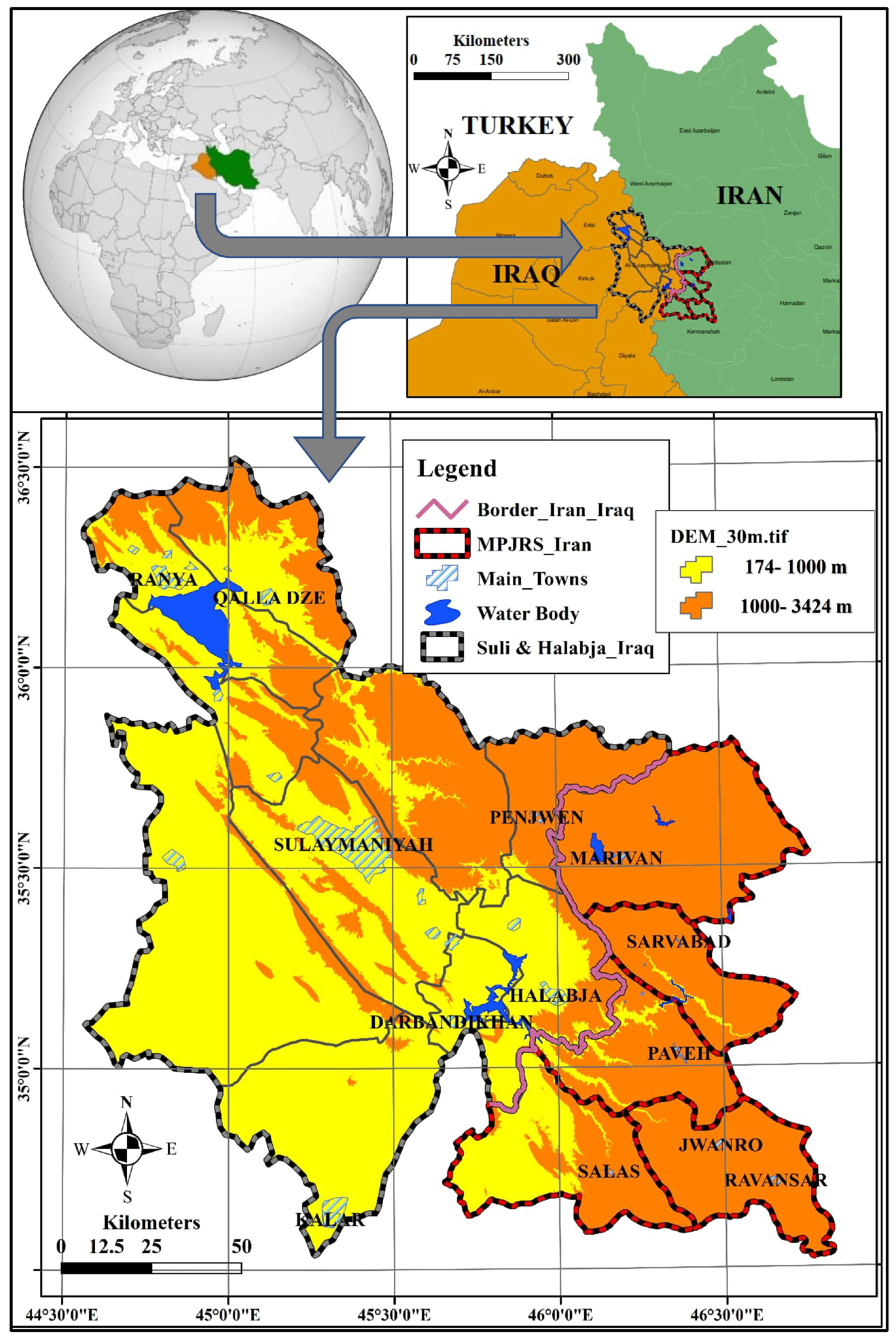
2.1. The Study Area
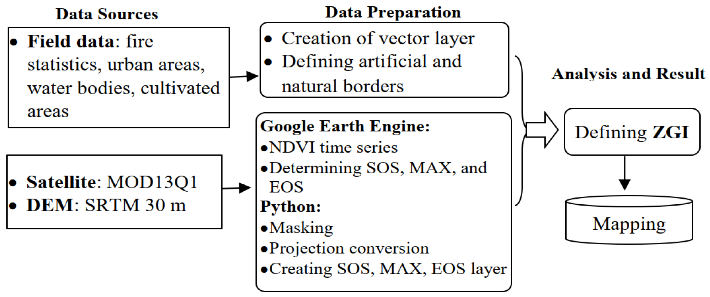
2.2. Data Sources
2.3. Zagros Grass Index
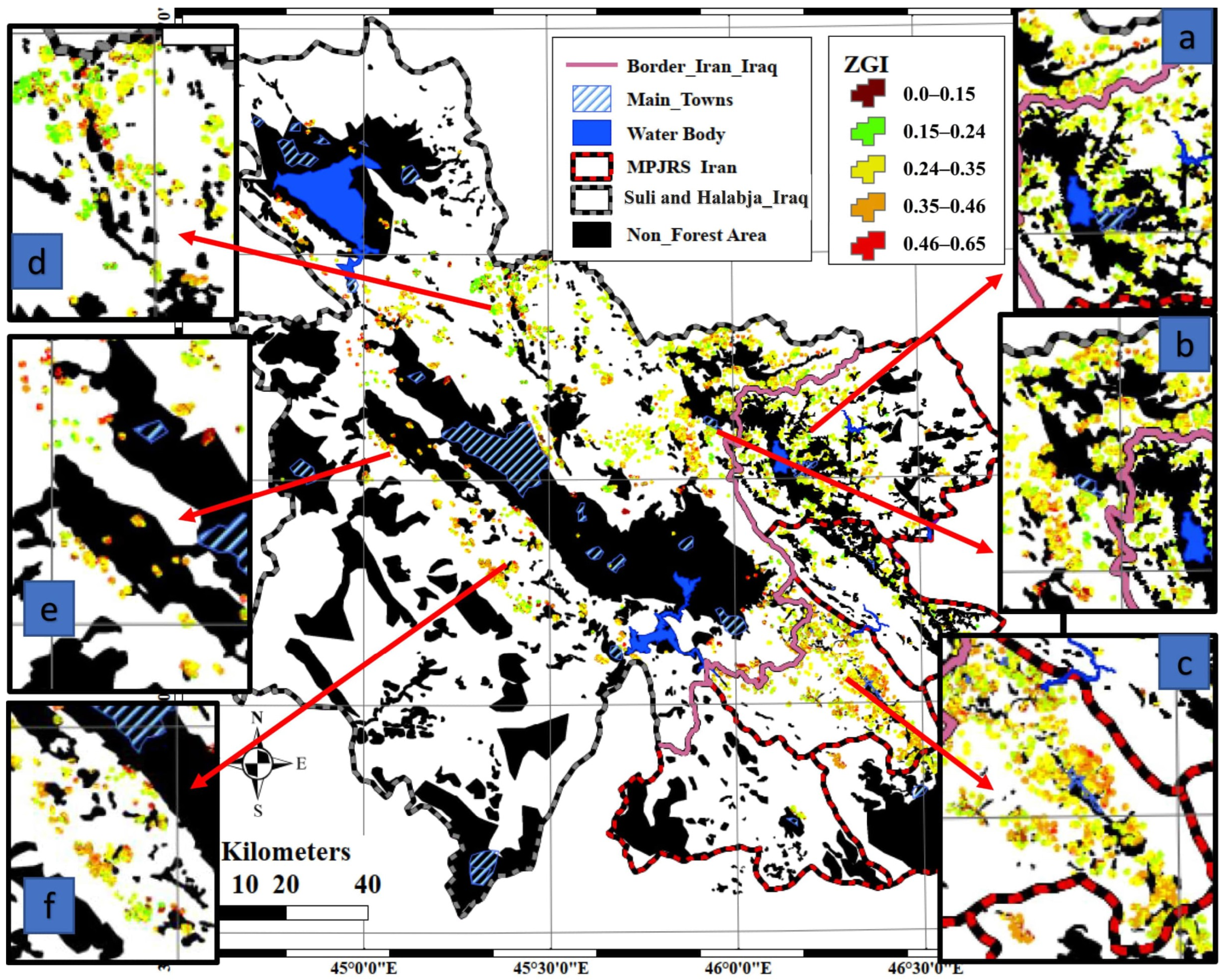
2.4. In Situ Information and Validation
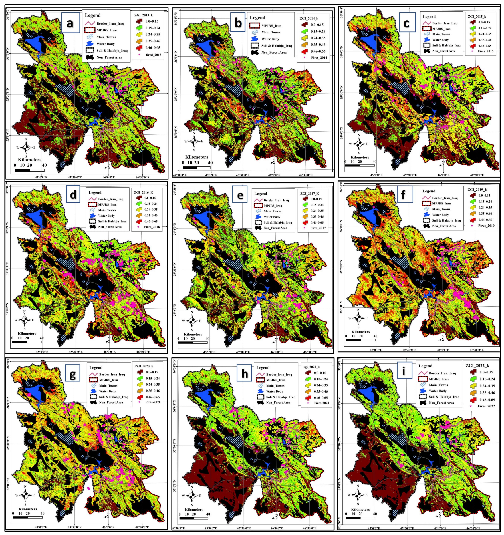
3. Results
4. Discussion
5. Conclusions
Author Contributions
Funding
Institutional Review Board Statement
Informed Consent Statement
Data Availability Statement
Acknowledgments
Conflicts of Interest
References
- Bajocco, S.; Rosati, L.; Ricotta, C. Knowing fire incidence through fuel phenology: A remotely sensed approach. Ecol. Model. 2010, 221, 59–66. [Google Scholar] [CrossRef]
- Pacheco, A.P.; Claro, J.; Fernandes, P.M.; De Neufville, R.; Oliveira, T.; Borges, J.G.; Rodrigues, J. Cohesive fire management within an uncertain environment: A review of risk handling and decision support systems. For. Ecol. Manag. 2015, 347, 1–17. [Google Scholar] [CrossRef]
- Pourtaghi, Z.S.; Pourghasemi, H.R.; Aretano, R.; Semeraro, T. Investigation of general indicators influencing on forest fire and its susceptibility modeling using different data mining techniques. Ecol. Indic. 2016, 64, 72–84. [Google Scholar] [CrossRef]
- Levine, J.S. Global Biomass Burning; MIT Press eBooks: Cambridge, MA, USA, 1991. [Google Scholar] [CrossRef]
- Cao, Y.; Wang, M.; Li, K. Wildfire susceptibility assessment in Southern China: A comparison of multiple methods. Int. J. Disaster Risk Sci. 2017, 8, 164–181. [Google Scholar] [CrossRef]
- Carlson, J.D.; Burgan, R.E. Review of users’ needs in operational fire danger estimation: The Oklahoma example. Int. J. Remote Sens. 2003, 24, 1601–1620. [Google Scholar] [CrossRef]
- Fernández-Guisuraga, J.M.; Suárez-Seoane, S.; Calvo, L. Radiative transfer modeling to measure fire impact and forest engineering resilience at short-term. Isprs J. Photogramm. Remote Sens. 2021, 176, 30–41. [Google Scholar] [CrossRef]
- Shaluf, I.M. Technological disaster stages and management. Disaster Prev. Manag. 2008, 17, 114–126. [Google Scholar] [CrossRef]
- Oliveira, S.; Laneve, G.; Fusilli, L.; GeorgiosEftychidis Nunes, A.; Lourenço, L.; López, A.S. A Common Approach to Foster Prevention and Recovery of Forest Fires in Mediterranean Europe; InTech eBooks: London, UK, 2017. [Google Scholar] [CrossRef]
- Rahimi, I.; Azeez, S.N.; Ahmed, I.H. Mapping Forest-Fire Potentiality Using Remote Sensing and GIS, Case Study: Kurdistan Region-Iraq; Springer Water: Berlin/Heidelberg, Germany, 2019; pp. 499–513. [Google Scholar] [CrossRef]
- Tian, X.; Zhao, F.; Shu, L.; Wang, M. Distribution characteristics and the influence factors of forest fires in China. For. Ecol. Manag. 2013, 310, 460–467. [Google Scholar] [CrossRef]
- Adab, H.; Kanniah, K.D.; Solaimani, K.; Sallehuddin, R. Modelling static fire hazard in a semi-arid region using frequency analysis. Int. J. Wildland Fire 2015, 24, 763. [Google Scholar] [CrossRef]
- Causes of Fire Incidences in Kurdistan Forests. ISNA. Available online: https://www.isna.ir/xd54pZ (accessed on 10 August 2019).
- Rojhelat Environmentalists Blame Government Inactivity for Frequent Forest Fires. RUDAW. Available online: https://www.rudaw.net (accessed on 17 August 2023).
- San-Miguel-Ayanz, J.; Durrant, T.; Boca, R.; Maianti, P.; Liberta’, G.; Artes, V.T.; Jacome, F.O.D.; Branco, A.; De, R.D.; Ferrari, D.; et al. Advance report on wildfires in Europe, Middle East and North Africa 2021. JRC Publ. Repos. 2021. [CrossRef]
- Press Corner. (n.d.). European Commission—European Commission. Available online: https://ec.europa.eu/commission/presscorner/detail/en/IP_23_5951 (accessed on 22 November 2023).
- Teodoro, A.C.; Santos, P.; Marques, J.E.; Ribeiro, J.; Mansilha, C.; Melo, A.; Duarte, L.; De Almeida, C.R.; Flores, D. An Integrated Multi-Approach to Environmental Monitoring of a Self-Burning Coal Waste Pile: The São Pedro da Cova Mine (Porto, Portugal) Study Case. Environments 2021, 8, 48. [Google Scholar] [CrossRef]
- Teodoro, A.C.; Amaral, A.L. A statistical and spatial analysis of Portuguese forest fires in summer 2016 considering Landsat 8 and Sentinel 2A data. Environments 2019, 6, 36. [Google Scholar] [CrossRef]
- Teodoro, A.C.; Duarte, L. Forest fire risk maps: A GIS open source application—A case study in Norwest of Portugal. Int. J. Geogr. Inf. Sci. 2013, 27, 699–720. [Google Scholar] [CrossRef]
- Dasgupta, S.; Qu, J.J.; Hao, X.; Bhoi, S. Evaluating remotely sensed live fuel moisture estimations for fire behavior predictions in Georgia, USA. Remote Sens. Environ. 2007, 108, 138–150. [Google Scholar] [CrossRef]
- Babu, K.V.S.; Vanama, V.S.K.; Roy, A.; Prasad, P. Assessment of forest fire danger using automatic weather stations and MODIS TERRA satellite datasets for the state Madhya Pradesh, India. In Proceedings of the 2017 International Conference on Advances in Computing, Communications and Informatics (ICACCI), Udupi, India, 13–16 September 2017; IEEE: Piscataway, NJ, USA, 2017. [Google Scholar] [CrossRef]
- Saah, D.; Tenneson, K.; Matin, M.A.; Uddin, K.; Cutter, P.; Poortinga, A.; Nguyen, Q.; Patterson, M.; Johnson, G.W.; Markert, K.; et al. Land cover mapping in data scarce Environments: Challenges and opportunities. Front. Environ. Sci. 2019, 7, 150. [Google Scholar] [CrossRef]
- Hellesen, T.; Matikainen, L. An Object-Based approach for mapping shrub and tree cover on grassland habitats by use of LIDAR and CIR orthoimages. Remote Sens. 2013, 5, 558–583. [Google Scholar] [CrossRef]
- Guirado, E.; Tabik, S.; Alcaraz-Segura, D.; Cabello, J.; Herrera, F. Deep-learning Versus OBIA for Scattered Shrub Detection with Google Earth Imagery: Ziziphus lotus as Case Study. Remote Sens. 2017, 9, 1220. [Google Scholar] [CrossRef]
- Ayhan, B.; Kwan, C. Tree, shrub, and grass classification using only RGB images. Remote Sens 2020, 12, 1333. [Google Scholar] [CrossRef]
- Zaabar, N.; Niculescu, S.; Mihoubi, M.K. Application of convolutional neural networks with Object-Based image analysis for land cover and land use mapping in coastal areas: A case study in Ain Témouchent, Algeria. IEEE J. Sel. Top. Appl. Earth Obs. Remote Sens. 2022, 15, 5177–5189. [Google Scholar] [CrossRef]
- Madasa, A.; Orimoloye, I.R.; Ololade, O.O. Application of geospatial indices for mapping land cover/use change detection in a mining area. J. Afr. Earth Sci. 2021, 175, 104108. [Google Scholar] [CrossRef]
- Diaz, B.M.; Blackburn, G.A. Remote sensing of mangrove biophysical properties: Evidence from a laboratory simulation of the possible effects of background variation on spectral vegetation indices. Int. J. Remote Sens. 2003, 24, 53–73. [Google Scholar] [CrossRef]
- Meshesha, D.T.; Ahmed, M.M.; Abdi, D.Y.; Haregeweyn, N. Prediction of grass biomass from satellite imagery in Somali regional state, eastern Ethiopia. Heliyon 2020, 6, e05272. [Google Scholar] [CrossRef] [PubMed]
- Fakhri, S.A.; Sayadi, S.; Naghavi, H.; Latifi, H. A novel vegetation index-based workflow for semi-arid, sparse woody cover mapping. J. Arid. Environ. 2022, 201, 104748. [Google Scholar] [CrossRef]
- Qian, Y.; Zhou, W.; Nytch, C.J.; Han, L.; Li, Z. A new index to differentiate tree and grass based on high resolution image and object-based methods. Urban For. Urban Green. 2020, 53, 126661. [Google Scholar] [CrossRef]
- Grigorieva, O.V.; Brovkina, O.; Saidov, A. An original method for tree species classification using multitemporal multispectral and hyperspectral satellite data. Silva Fenn. 2020, 54, 10143. [Google Scholar] [CrossRef]
- Eskandari, S.; Jaafari, M.R.; Oliva, P.; Ghorbanzadeh, O.; Blaschke, T. Mapping land cover and tree canopy cover in Zagros forests of Iran: Application of Sentinel-2, Google Earth, and field data. Remote Sens. 2020, 12, 1912. [Google Scholar] [CrossRef]
- Shafeian, E.; Fassnacht, F.E.; Latifi, H. Mapping fractional woody cover in an extensive semi-arid woodland area at different spatial grains with Sentinel-2 and very high-resolution data. Int. J. Appl. Earth Obs. Geoinf. 2021, 105, 102621. [Google Scholar] [CrossRef]
- Nasir, S.M.; Kamran, K.V.; Blaschke, T.; Karimzadeh, S. Change of land use/land cover in kurdistan region of Iraq: A semi-automated object-based approach. Remote Sens. Appl. Soc. Environ. 2022, 26, 100713. [Google Scholar] [CrossRef]
- Rash, A.; Mustafa, Y.T.; Hamad, R. Quantitative assessment of Land use/land cover changes in a developing region using machine learning algorithms: A case study in the Kurdistan Region, Iraq. Heliyon 2023, 9, e21253. [Google Scholar] [CrossRef]
- Aragoneses, E.; Chuvieco, E. Generation and mapping of fuel types for fire risk assessment. Fire 2023, 4, 59. [Google Scholar] [CrossRef]
- Pettinari, M.L.; Chuvieco, E. Fire Behavior Simulation from Global Fuel and Climatic Information. Forests 2017, 8, 179. [Google Scholar] [CrossRef]
- Motlagh, M.G.; Alchin, A.A.; Daghestani, M. Detection of high fire risk areas in Zagros Oak forests using geospatial methods with GIS techniques. Arab. J. Geosci. 2022, 15, 835. [Google Scholar] [CrossRef]
- Taufik, A.; Ahmad, S.S.S.; Ahmad, A. Classification of Landsat 8 satellite data using NDVI tresholds. J. Telecommun. Electron. Comput. Eng. 2016, 8, 37–40. Available online: https://jtec.utem.edu.my/jtec/article/view/1168 (accessed on 22 November 2023).
- Pettorelli, N.; Vik, J.O.; Mysterud, A.; Gaillard, J.; Tucker, C.J.; Stenseth, N.C. Using the satellite-derived NDVI to assess ecological responses to environmental change. Trends Ecol. Evol. 2005, 20, 503–510. [Google Scholar] [CrossRef] [PubMed]
- McInnes, W.S.; Smith, B.; McDermid, G.J. Discriminating native and nonnative grasses in the dry mixedgrass prairie with MODIS NDVI Time Series. IEEE J. Sel. Top. Appl. Earth Obs. Remote Sens. 2015, 8, 1395–1403. [Google Scholar] [CrossRef]
- Clementini, C.; Del Frate, F.; Pomente, A.; Salvucci, G.D.; Teillard, F.; Kanamaru, H.; Fujisawa, M.; Mottet, A.; Heureux, A. Grass Biomass Estimation on Zambian pastures for future climate Change Effects Mitigation and adaptation using satellite imagery and neural network technique. In Proceedings of the IGARSS 2018—2018 IEEE International Geoscience and Remote Sensing Symposium, Valencia, Spain, 22–27 July 2018; IEEE: Piscataway, NJ, USA, 2018. [Google Scholar] [CrossRef]
- Royimani, L.; Mutanga, O.; Dube, T. Progress in Remote sensing of grass senescence: A review on the challenges and opportunities. IEEE J. Sel. Top. Appl. Earth Obs. Remote Sens. 2021, 14, 7714–7723. [Google Scholar] [CrossRef]
- Rahimi, I.; Duarte, L.; Teodoro, A.C. A new indicator for enhancing fire fuel mapping in Marivan forests, west of Iran. In Proceedings of the SPIE 12734, Earth Resources and Environmental Remote Sensing/GIS Applications, Amsterdam, The Netherlands, 6–9 September 2023. [Google Scholar] [CrossRef]
- Abu-Rabia, A. Ethno-Botanic Treatments for Paralysis (FALIJ) in the Middle East. Chin. Med. 2012, 3, 157–166. [Google Scholar] [CrossRef]
- El-Moslimany, A.P. Ecology and late-Quaternary history of the Kurdo-Zagrosian oak forest near Lake Zeribar, western Iran. Vegetation 1986, 68, 55–63. [Google Scholar] [CrossRef]
- Pourhashemi, M.; Zandebasiri, P. Panahi, Structural characteristics of oak coppice stands of Marivan Forests. Iran. J. Plant Res. 2014, 27, 766–776. [Google Scholar]
- Jazirehi, M.H.; Rostaaghi, E.M. Silviculture in Zagros; University of Tehran Press: Tehran, Iran; Scientific Research Publishing: Wuhan, China, 2003; 560p, Available online: https://www.scirp.org/reference/referencespapers?referenceid=1852053 (accessed on 20 November 2023).
- Kurdistan Regional Government. KRG Administered Territory. 2023. Available online: https://gov.krd/english (accessed on 23 November 2023).
- Kurdistan Region Presidency. Oil-for-Food Distribution Plan. Approved by the UN, December. UNEP. Available online: https://presidency.gov.krd/krp/english/ndisplay.aspx?sm=5yBwBg+oqQY= (accessed on 23 November 2023).
- Rahimzadeh-Bajgiran, P.; Darvishsefat, A.A.; Khalili, A.; Makhdoum, M. Using AVHRR-based vegetation indices for drought monitoring in the Northwest of Iran. J. Arid. Environ. 2008, 72, 1086–1096. [Google Scholar] [CrossRef]
- USGS EROS Archive—Digital Elevation—Shuttle Radar Topography Mission (SRTM) 1 ArC-Second Global|U.S. Geological Survey. (July 2018). Available online: https://www.usgs.gov/centers/eros/science/usgs-eros-archive-digital-elevation-shuttle-radar-topography-mission-srtm-1 (accessed on 20 November 2023).
- Kheshti, M. Protect Iran’s Zagros forests from wildfires. Science 2020, 369, 1066. [Google Scholar] [CrossRef] [PubMed]
- Duarte, L.; Teodoro, A.C.; Gonçalves, H. Deriving phenological metrics from NDVI through an open source tool developed in QGIS. In Proceedings of the Volume 9245, Earth Resources and Environmental Remote Sensing/GIS Applications V, 924511, Amsterdam, The Netherlands, 23–25 September 2014. [Google Scholar]
- Malhi, R.K.M.; Kiran, G.S.; Shah, M.N.; Mistry, N.; Bhavsar, V.H.; Singh, C.P.; Bhattarcharya, B.K.; Townsend, P.A.; Mohan, S. Applicability of Smoothing Techniques in Generation of Phenological Metrics of Tectona grandis L. Using NDVI Time Series Data. Remote Sens. 2021, 13, 3343. [Google Scholar] [CrossRef]
- Chen, X.; Xu, C.; Tan, Z. An analysis of relationships among plant community phenology and seasonal metrics of Normalized Difference Vegetation Index in the northern part of the monsoon region of China. Int. J. Biometeorol. 2001, 45, 170–177. [Google Scholar] [CrossRef] [PubMed]
- Hott, M.C.; Carvalho, L.M.T.; Antunes, M.A.H.; Resende, J.C.; Rocha, W.S.D. Analysis of Grassland Degradation in Zona da Mata, MG, Brazil, Based on NDVI Time Series Data with the Integration of Phenological Metrics. Remote Sens. 2019, 11, 2956. [Google Scholar] [CrossRef]
- Ji, Z.; Pan, Y.; Zhu, X.; Wang, J.; Li, Q. Prediction of Crop Yield Using Phenological Information Extracted from Remote Sensing Vegetation Index. Sensors 2021, 21, 1406. [Google Scholar] [CrossRef]
- Li, M.; Bao, G.; Tong, S.; Yin, S.; Bao, Y.; Jiang, K.; Hong, Y.; Tuya, A.; Huang, X. Elevation-dependent response of spring phenology to climate and its legacy effect on vegetation growth in the mountains of northwest Mongolia. Ecol. Indic. 2021, 126, 107640. [Google Scholar] [CrossRef]
- Ziello, C.; Estrella, N.; Kostova, M.; Koch, E.; Menzel, A. Influence of altitude on phenology of selected plant species in the Alpine region (1971–2000). Clim. Res. 2009, 39, 227–234. Available online: https://www.jstor.org/stable/24870440 (accessed on 10 December 2023). [CrossRef]
- Yang, J.; Weisberg, P.J.; Bristow, N. Landsat remote sensing approaches for monitoring long-term tree cover dynamics in semi-arid woodlands: Comparison of vegetation indices and spectral mixture analysis. Remote Sens. Environ. 2012, 119, 62–71. [Google Scholar] [CrossRef]
- Higginbottom, T.P.; Symeonakis, E.; Meyer, H.; Van Der Linden, S. Mapping fractional woody cover in semi-arid savannahs using multi-seasonal composites from Landsat data. Isprs J. Photogramm. Remote Sens. 2018, 139, 88–102. [Google Scholar] [CrossRef]
- Yulianto, F.; Kushardono, D.; Budhiman, S.; Nugroho, G.; Chulafak, G.A.; Dewi, E.K.; Pambudi, A.I. Evaluation of the threshold for an improved surface water extraction index using optical remote sensing data. Sci. World J. 2022, 2022, 4894929. [Google Scholar] [CrossRef]
- MosaBeigi, M.; Mirza Beigi, F. Zoning forest fire risk in the Manesht and Qalarang Protected Area using a network analysis model and geographic information system. Environ. Sci. 2017, 14, 175–188. (In Persian) [Google Scholar]
- Zaïdi, A. Predicting wildfires in Algerian forests using machine learning models. Heliyon 2023, 9, e18064. [Google Scholar] [CrossRef] [PubMed]
- Scott, J.R.; Burgan, R.E. Standard fire behavior fuel models: A comprehensive set for use with Rothermel’s surface fire spread model. In General Technical Report; U.S. Department of Agriculture, Forest Service, Rocky Mountain Research Station: Fort Collins, CO, USA, 2005; 72p. [Google Scholar] [CrossRef]
- Wragg, P.D.; Mielke, T.; Tilman, D. Forbs, grasses, and grassland fire behaviour. J. Ecol. 2018, 106, 1983–2001. [Google Scholar] [CrossRef]
- Pourreza, M.; Hosseini, S.M.; Sinegani, A.A.S.; Matinizadeh, M.; Alavai, S.J. Herbaceous species diversity in relation to fire severity in Zagros oak forests, Iran. J. For. Res. 2014, 25, 113–120. [Google Scholar] [CrossRef]
- Chuvieco, E.; Riaño, D.; Van Wagtendonk, J.W.; Morsdof, F. Fuel loads and fuel type mapping. Ser. Remote Sens. 2003, 4, 119–142. [Google Scholar] [CrossRef]
- Sagheb-Talebi, K.; Sajedi, T.; Pourhashemi, M. Forests of Iran. In Plant and Vegetation; Springer: Berlin/Heidelberg, Germany, 2014. [Google Scholar] [CrossRef]
- Peel, M.C.; Finlayson, B.; McMahon, T.A. Updated world map of the Köppen-Geiger climate classification. Hydrol. Earth Syst. Sci. 2007, 11, 1633–1644. [Google Scholar] [CrossRef]


| Data | Data Type | Projection | Spatial Resolution (m) | Period | Resource |
|---|---|---|---|---|---|
| Satellite Data | MODIS/MOD13Q1 | Sinusoidal | 250 | 1 January 2013–31 December 2022 | USGS 4 |
| DEM 1/SRTM 2 | UTM 3 | 30 | - | USGS | |
| In situ Data | Fire statistics | UTM | - | 2013–2022 | Officials |
| Shapefiles (water body, Iran and Iraq national and subnational layers) | UTM | - | - | Officials Report |
Disclaimer/Publisher’s Note: The statements, opinions and data contained in all publications are solely those of the individual author(s) and contributor(s) and not of MDPI and/or the editor(s). MDPI and/or the editor(s) disclaim responsibility for any injury to people or property resulting from any ideas, methods, instructions or products referred to in the content. |
© 2024 by the authors. Licensee MDPI, Basel, Switzerland. This article is an open access article distributed under the terms and conditions of the Creative Commons Attribution (CC BY) license (https://creativecommons.org/licenses/by/4.0/).
Share and Cite
Rahimi, I.; Duarte, L.; Teodoro, A.C. Zagros Grass Index—A New Vegetation Index to Enhance Fire Fuel Mapping: A Case Study in the Zagros Mountains. Sustainability 2024, 16, 3900. https://doi.org/10.3390/su16103900
Rahimi I, Duarte L, Teodoro AC. Zagros Grass Index—A New Vegetation Index to Enhance Fire Fuel Mapping: A Case Study in the Zagros Mountains. Sustainability. 2024; 16(10):3900. https://doi.org/10.3390/su16103900
Chicago/Turabian StyleRahimi, Iraj, Lia Duarte, and Ana Cláudia Teodoro. 2024. "Zagros Grass Index—A New Vegetation Index to Enhance Fire Fuel Mapping: A Case Study in the Zagros Mountains" Sustainability 16, no. 10: 3900. https://doi.org/10.3390/su16103900
APA StyleRahimi, I., Duarte, L., & Teodoro, A. C. (2024). Zagros Grass Index—A New Vegetation Index to Enhance Fire Fuel Mapping: A Case Study in the Zagros Mountains. Sustainability, 16(10), 3900. https://doi.org/10.3390/su16103900


