Article

The Impact of Beaver Dams on the Dynamic of Groundwater Levels at Łąki Soleckie

1
Institute of Civil Engineering, Warsaw University of Life Sciences, 02-776 Warsaw, Poland
2
Institute of Environmental Engineering, Warsaw University of Life Sciences, 02-776 Warsaw, Poland
3
Institute of Soil Science and Plant Cultivation, State Research Institute, 24-100 Pulawy, Poland
*
Author to whom correspondence should be addressed.
Sustainability 2024, 16(10), 4135; https://doi.org/10.3390/su16104135
Submission received: 25 February 2024 / Revised: 11 May 2024 / Accepted: 13 May 2024 / Published: 15 May 2024

Abstract

:
Areas excluded from agricultural production are susceptible to the presence of beaver families. The most significant changes occur during the initial period, when agricultural utilization is abandoned and beavers establish their presence on the land. During this period, some parcels remain uncultivated, while agricultural activities persist in neighboring areas. This situation is accompanied by the destruction of beaver dams, especially during periods of abundant water resources, and notably during intensive fieldwork. The article presents field studies aimed at determining the extent to which constructed and operational beaver dams contribute to changes in groundwater levels in drained peatland areas. In order to protect and sustainably use peat soils, it is necessary to maintain their high moisture content by ensuring a high groundwater level elevation. This can be achieved through the use of existing damming structures in the area (levees, weirs). Beaver dams can also serve a similar function, blocking the outflow of water from peat lands by raising the water level and consequently retaining it naturally. The specific objective was to develop principles for verifying factors influencing the effects of beaver dam construction on groundwater levels in fields within their range of influence. The water table levels within the study area during rainless periods were influenced by water levels in ditches, dependent on beaver activity in the nearby river. Beaver activities, manifested through dam construction, were influenced by periodic water resources in the river, defined by the cumulative monthly precipitation. Factors affecting groundwater levels in rainless periods on the plots also included the distance from the river cross-section and the permeability of soils expressed by the filtration coefficient of the active layer. Beaver dams had the greatest impact on stabilizing the water table in the soil profile closest to the river.

1. Introduction

Groundwater in meadow habitats is closely tied to environmental conditions, human economic activities, and other factors, such as the presence and activities of beavers [1]. The settlement of beavers and their activities induce environmental changes, particularly in water levels and retention in streams and ditches [2,3,4,5,6,7].
Due to their rapid adaptation to environmental conditions, beavers colonize areas characterized by high natural and climatic diversity [8,9,10,11,12]. Their ability to survive and adapt to aquatic–terrestrial environments stems from both their body structure and high dietary tolerance [13]. Beaver activities are often associated with forest stand damage and an increase in the volume of retained water, estimated at around 5% [14]. This is a significant volume, especially when the threat of drought intensifies [15,16,17].
The increase in soil moisture in the riparian zone induces changes in the composition of plant species. In beaver ponds, there is often an observed increase in the number of fish, invertebrates, and amphibians, with a concurrent rise in bird and small mammal populations in their vicinity, fostering biodiversity development [18]. Losses in the forest stand caused by beaver activities lead to increased sunlight exposure, with a preference for certain plant and animal species [19,20]. Sunlight exposure alters soil temperature, influencing biological processes such as the decomposition of organic matter [21,22].
The activity of beavers restricts water outflow in drainage systems with a dense network of ditches where maintenance activities are no longer conducted [23]. This causes an increase in moisture, which holds particular significance for shallow peat soils, as it limits their subsidence and disappearance [24]. The primary countermeasure to address these phenomena involves blocking surface water drainage and raising the water table [12]. This is achieved through interventions utilizing existing gravitational systems of drainage–irrigation ditches and modified drainage systems equipped with impounding devices [25,26,27,28,29,30,31], complemented by modern computational techniques [32,33]. Accelerating climate changes exacerbate the deficit of atmospheric precipitation during the growing season and worsen soil–water–air relations [34,35]. In Poland, the annual rainfall ranges from 400 to over 600 mm, with 712.5 mm recorded in 2020 and an average national rainfall of 644.0 mm in 2021 [36].
In this article, changes in land use patterns were identified both before the establishment of habitat protection forms and during the implementation of protection measures, coinciding with the settlement of beaver families. The influence of beaver dam occurrences on the groundwater regime of the area, which is part of a seepage irrigation system on shallow organic soils, was determined. The dynamics of groundwater changes on a section of the Łąki Soleckie site were presented in relation to the periodic presence of beaver dams. In the assessment of this influence, the primary predictors (X1, X2) included surface water levels in two drainage ditches that serve as inflows to the Mała River. The predictor group was supplemented with factors characterizing the location (X3) of cross-sections in relation to the dams on the Mała River, soil conditions (X4), and meteorological precipitation (X5) influencing beaver activity.

2. Materials and Methods

2.1. Research Facility

The research was conducted on a segment of an area situated on organic soils in the valley of the Mała River, where agricultural production and planned water management are not practiced. The analyzed plot is part of the protected habitat area known as Łąki Soleckie (area number PLH140055), located in the Mazowieckie Voivodeship, Piaseczno County, in the municipality of Góra Kalwaria (Figure 1). The protected area encompasses the peat-filled valley of the Mała River, a right tributary of the Jeziorka River. The Mała River watershed covers an area of 72.8 km2 [37]. The botanical composition of the peatland includes low mossy and mossy-reed peats with an intermediate degree of decomposition [38]. The site has seen a rapidly acclimatizing beaver population and, at the same time, the human abandonment of crops in support of increased natural habitat. This is an example of change where humans tolerate and yield to the impact of the sustainable use of natural environmental resources. In this case, humans consciously share environmental resources with beavers.
In the 1970s, 62 drainage–irrigation ditches were constructed in the peatland area, forming part of the seepage irrigation system [39]. Currently, this system is no longer utilized for irrigation purposes. At the beginning of the 21st century, agricultural production was discontinued, and recreational activities were developed, associated with the operation of a nearby horse stable. Simultaneously, European beaver (Castor fiber) activity, involving the construction of dams along the Mała River channel, was observed in this area.
The studied plot, covering an area of 3.15 hectares, is situated within the northwestern part of the Łąki Soleckie complex, spanning 36.8 hectares. It is located north of National Road No. 79, along the left bank of the Mała River, extending to the border of the Chojnów Landscape Park (Figure 1). Over the past two decades, the utilization of this meadow complex has undergone changes. The documented land use in 2001, as shown in Figure 1a, was exclusively for agricultural production. In 2011, the protected Natura 2000 area Łąki Soleckie PLH140055, covering an area of 222.06 hectares, was established. The central part of the studied complex, occupied by a horse stable and designated for breeding and recreational purposes, was excluded from this area (Figure 1b). By 2020, another recreational center with a horse stable was established in the studied area. Simultaneously, the intensive mowing of meadows was discontinued, limited to a single cut each year, carried out on 22 July 2020, 16 June 2021, and 25 June 2022. Beavers also appeared along this stretch of the Mała River during this period (Figure 1c,d). Beaver activity led to water retention in the river and nearby ditches, preventing hay harvests. In 2020, only 68% of the usable area of the plot was mowed (Figure 1c). The existing beaver dam and high groundwater levels prevented the entry of agricultural machinery into the part of the plot located along the Mała River.
For detailed analyses, a plot located within the immediate range of three beaver dams was selected (Figure 1) (EPSG:2180: N: 52°02′17.187″, E: 21°05′48.759″). Dam D1 at km 8+350 was present in 2020, while dams D2 at km 8+195 and D3 at km 8+045 existed from 2021 to 2022. The analyzed plot is situated on the left bank of the Mała River and lies between the mouth of drainage ditch R-29, measuring 320 m at km 8+395 (X1R-29), and the mouth of drainage ditch R-27, measuring 360 m at km 8+305 (X2R-27) (X1, X2—analyzed predictors). The spacing between the ditches is 90 m. Four cross-sectional profiles, P1, P2, P3, and P4, perpendicular to the longitudinal axis of the plot and the ditch axis, were delineated on the site. The distances (L) of the profiles from the Mała River are as follows: L1 = 70 m (X3L1), L2 = 150 m (X3L2), L3 = 216 m (X3L3), L4 = 300 m (X3L4) (Figure 1) (X3—analyzed predictor).
In the measurement cross-sections P1, P2, and P3, shallowly drained peat-muck soils are present to a depth of 0.45 m, followed by medium-grained sand below [40]. For the active peat layer in these cross-sections, the average filtration coefficient is kt = 5.2 × 10⁻⁶ m·s−1 (0.4471 m·d−1) (X4k1, X4k2, X4k3) (X4—analyzed predictor) [41]. In the upper part of the plot, from measurement cross-section P4 to its boundary, there is mineral soil formed from loose sands (pl), with an average filtration coefficient kp = 3.0 × 10⁻⁴ m·s−1 (25.92 m·d−1) (X4k4) [40].

2.2. Research Methodology

During the measurement periods of the years 2020–2022 (from 1 April to 31 October), a total of 642 days, including 214 days each year, M = 180 observational series were conducted (Table 1). In 2020, 62 series were conducted, in 2021, 60 series were conducted, and in 2022, 58 series were completed. Each series included measurements of water levels in the Mała River near the existing dams, in ditches R-29 and R-27 (at the boundaries of measurement cross-sections P1–P4), and in wells S1, S2, S3, and S4 (Figure 1). The dataset size for the four measurement cross-sections was M1–4 = 720 data points (Table 1). The analysis was conducted in the following stages of the procedure:
E1—presentation of measurement results for individual cross-sections for M = 180 series and for the combined set M1–4 = 720 data points;
E2—selection of measurements without daily precipitation using the criterion Pd = 0.0 mm, while satisfying the criterion of the presence of beaver dams, resulting in N = 81 series, N1–4 = 324 data points;
E3—selection of measurements without periodic precipitation over time since the previous measurement based on the criterion Pp = 0.0 mm, W = 41 series, W1–4 = 164 data points;
E4—selection of measurements without precipitation over a period not shorter than 5 days before the measurement based on the criterion Pd5 = 0.0 mm, Z = 18 series, Z1–4 = 72 data points;
E5—identification of predictors, linear correlation analysis, and multiple linear regression analysis, followed by model verification on the training set Z1–4 = 72 data points and on the basic set M1–4 = 720 data points.

2.3. Surface Water Levels

Water level measurements in the Mała River above and below the beaver dams, as well as in the ditches, were taken using water gauges, while groundwater measurements in the wells were conducted using a hydrogeological brass whistle with a diameter of Ø 25 mm and a length of 235 mm with plates (so-called correction rings are used for more accurate measurement +/1 cm). In this article, the dataset included measurements of all the variables studied from the M set (720 items). This was the basic dataset used only at the E-1 stage. By applying different, increasingly difficult criteria at subsequent analysis stages E-2, E-3, and E-4, an increasingly smaller dataset was obtained each time.

2.4. Precipitation and Beaver Activity

The following precipitation measurements and criteria limiting the number of series were analyzed in the article (Table 1):
Pd (mm)—daily precipitation measured. During the period of beaver dams, the criterion of no daily precipitation Pd = 0.0 mm occurred in N = 81 measurement series;
Pp (mm)—periodic precipitation, daily precipitation sums in the period between measurements. Criterion Pp = 0.0 mm occurred for W = 41 measurement series;
Pd5 (mm)—5 days or more without precipitation. The five-day period was determined based on the reaction time of the water level in the middle of the plot to the elevated water level in the ditch [42]. Under average conditions observed in ditch R-29 and the irrigated plot during the three-year measurement period, the average travel time was 4.7 days. According to the criterion Pd5 = 0.0 mm, Z = 18 measurement series were established;
Pm (mm)—monthly precipitation and the monthly average;
Pm7 (mm)—over a 7 month precipitation measurement period and the daily average over the 7 month period.

2.5. Groundwater Levels

The selected measurements for further analysis represent a dataset of groundwater elevations on the site influenced by beaver dams, with limited rainfall impact. The influence of beaver dams on groundwater elevations was determined by the water levels in the ditches X1R-29 (m.a.s.l.) and X2R-27 (m.a.s.l.). The maintained water levels in the dams were related to water availability and beaver activity. Monthly rainfall sums X5Pm (mm) were utilized as an indicator of water resources affecting beaver activity.

2.6. Predictive Model

The overall relationship describing groundwater elevations in the center of the plot was characterized by variables influenced by the existing beaver dams, with the simultaneous elimination of other influences not related to the presence of dams. The linear model, defined by five predictors, takes the following form:
Y S = m 1 X 1 R - 29 + m 2 X 2 R - 27 + m 3 X 3 L + m 4 X 4 k + m 5 X 5 P m + B
where YS—groundwater level in wells S1, S2, S3 and S4 (m.a.s.l.); X1R-29—water level in the ditch R-29 (m.a.s.l.) (Figure 2); X2R-27—water level in ditch R-27 (m.a.s.l.) (Figure 2); X3L—cross-section distance from the river L (m) (Figure 1); X4k—filtration coefficient in the cross-section k (m·s−1); X5Pm—monthly precipitation sum Pm (mm) (Table 2); and m1, m2, m3, m4, m5, and B—function coefficients.

3. Results and Discussion

3.1. Surface Water Levels

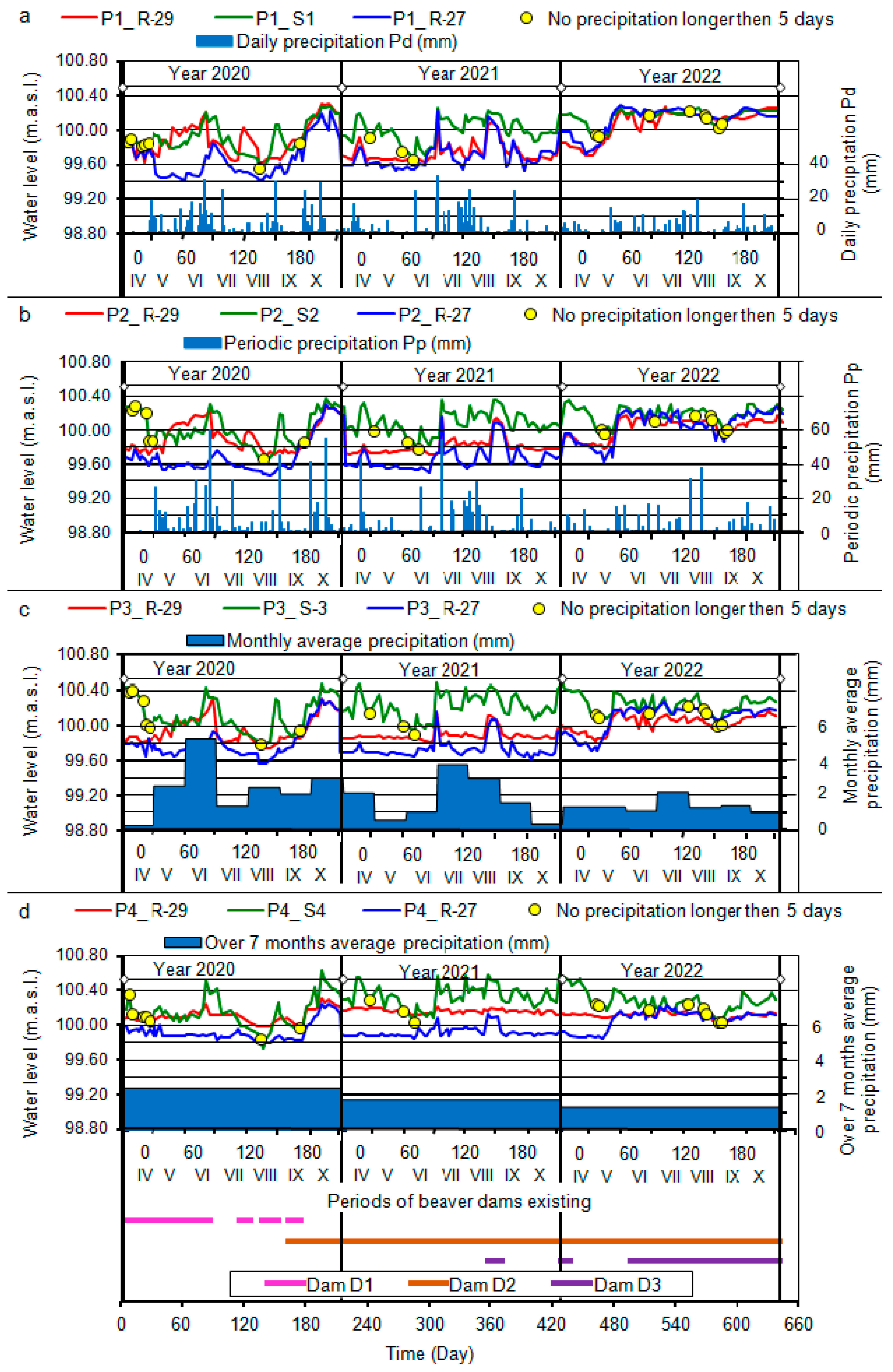
In the year 2020, there was a beaver dam (D1) in the channel of the Mała River, positioned halfway across the analyzed plot, between the outlets of ditches R-29 and R-27 (Figure 1). This dam influenced the water levels in ditches R-29 and R-27 (2020 in Figure 2). After 21 May 2020, due to the beavers raising the dam and intense rainfall, the water table rose above dam D1, and in cross-sections P1 and P2 of ditch R-29, it increased by 60.0 cm, in P3 by 40.0 cm, and in P4 by 20.0 cm relative to ditch R-27. After the dismantling of dam D1 on 26 June 2020, the water level in cross-sections P1 and P2 of ditch R-29 decreased. When dam D1 was rebuilt on 25 July 2020, the water impoundment in cross-sections P1 and P2 of ditch R-29 rose again to a height of 50.0 cm relative to ditch R-27. The subsequent removal and reconstruction of the dam on 10 August 2020 and 5 September 2020, along with intense rainfall, led to the maintenance of an elevated water table in ditch R-29 compared to ditch R-27.
On 10 September 2020, another beaver dam (D2) was formed, located at km 8+195 (Figure 1). Dam D1 existed until 22 September 2020, when it was removed once again, and it was not rebuilt by beavers in that location. After the destruction of dam D1, the ditches supplying the plot remained under the influence of the water level in the upper part of dam D2. This caused the difference in water table elevations in both ditches to fluctuate in the range of 0.0–20.0 cm (2020 in Figure 2).
In 2021, beaver dam D2 was present in the Mała River channel, located 105 m below the confluence of ditch R-27 (Figure 1). Both analyzed ditches remained under the influence of the water level in the upper part of dam D2 (2021 in Figure 2). The changes in the water table in ditches R-29 and R-27 followed a similar pattern. The greatest differences in water table elevations, amounting to 30.0 cm, occurred in cross-section P4, while the smallest, at 10.0 cm, were observed in cross-section P1. Increased beaver activity was noted on 8 June 2021, when they raised dam D2, causing an increase in the water table elevation in ditch R-29. During this time, the water in ditch R-27 remained 30 cm lower than in ditch R-29. On 20 August 2021, there was an increase in the water table elevations in both the upper and lower parts of dam D2 due to the appearance of another beaver dam, D3, located 150 m below D2. This temporarily raised the water level in ditch R-27, while ditch R-29 reacted only slightly to this change. Dam D3 was destroyed on 5 September 2021, causing the difference in water levels in the ditches to fluctuate within a range of 20.0 cm in P4 and 10.0 cm in P1 (2021 in Figure 2).
As of 1 April 2022, two beaver dams, D2 and D3, were present (Figure 1), and the outlets of both ditches, R-29 and R-27, were located above dam D2. The existing dam D3 did not have a direct impact on the water levels in the ditches. During this period, the water level difference in ditch cross-section P4 was 25.0 cm, with smaller differences in the cross-sections closer to the river. In cross-section P1, the difference was negative, meaning that the water in ditch R-27 settled below the elevations in ditch R-29. From 5 May 2022, there was an increase in the water table elevation in the upper part, due to the raising of dam D2. This led to the stabilization of water elevations in ditch R-29 at a level 20.0 cm below ditch R-27, and this situation persisted until the end of 2022 (2022 in Figure 2).
The interactions at individual dam locations, D1, D2, and D3, differed mutually. In 2020, with the highest cumulative precipitation over the seven-month period (Pm7 = 524.2 mm, seven-month daily average 2.45 mm, Year 2020; Figure 2d), beaver activity was determined to be the lowest. During this year, beavers built and maintained one dam at location D1. The average activity was defined in 2021 with a precipitation sum of Pm7 = 385.5 mm (seven-month daily average 1.80 mm, Year 2021 Figure 2d) and the highest monthly sums in July and August. In this year, beavers moved the dam to location D2 and started building another dam at location D3. The highest activity was observed in 2022 with the lowest precipitation sum of Pm7 = 298.2 mm (seven-month daily average 1.39 mm, Year 2021; Figure 2d) and evenly distributed monthly sums. In 2022, the beavers maintained two dams, one at location D2 and the other at location D3, where they maintained the highest retention levels. It can be observed that beaver behavior was mostly correlated with monthly rainfall periods, and this can be considered an indicator of their activity. Depending on the monthly precipitation values, beavers had a direct impact on water conditions in the river, as well as indirectly in the ditches and within the analyzed plot.
The beaver dams, by maintaining impoundment in the Mała River, influenced the water levels in the ditches R-29 and R-27, causing water to flow from the ditches into the interior of the plot. Comparing the groundwater levels in wells for the plot cross-sections in different years, it is evident that they depend on the distance of the cross-section from the Mała River (Figure 2). A predictor X3L, representing the distance of the cross-section from the Mała River, was introduced into the analysis. Along the plot cross-sections, there are variable soil conditions, with shallow organic soils occurring in cross-sections P1, P2, and P3, while mineral soil is present in cross-section P4. The variability of these conditions is described by the predictor X4k, expressing the value of the filtration coefficient of the active soil layer present in the cross-section.

3.2. Precipitation and Beaver Activity

Changes in water levels in the Mała River resulting from dam construction have had various effects on ditches and groundwater within the plot (Figure 2, Table 2). Short-term changes in water levels in the river were not noticeable in the center of the plot, whereas longer periods of stabilization of the water level in the river also caused changes in groundwater levels within the plot.
Precipitation was divided into two forms of impact: the first, as rainfall on the surface of the study area directly influencing groundwater, and the second, as rainfall occurring outside the field, affecting the water resources of the river dammed by beavers. The measurement series with the first form of rainfall impact were excluded from the analysis. Only series without rainfall were considered for further analysis, in accordance with the criterion. Monthly precipitation (Pm in mm) from Table 2 was adopted as the predictor (X5Pm) describing beaver activity.
Changes in elevations (meters above sea level) in the subsequent steps of the conducted procedure using the described criteria are presented in Figure 3 in the form of graphs S = f(R-29, R-27). The analysis of the original measurement data (Figure 3a) allowed for the identification of data characterizing changes in groundwater elevations during the existence of beaver dams. Applying the criterion of no rainfall during measurements and the criterion of the existence of dams resulted in the dataset shown in Figure 3b. For the criterion of no periodic rainfall, the graph of the dataset is presented in Figure 3c. The dataset after applying the criterion of no rainfall for a period of 5 days or longer before the measurement is illustrated in Figure 3d. The application of individual criteria limited the datasets to values representative of rainless periods, during which water levels remained under the influence of beaver-dammed water levels in the Mała River.

3.3. Groundwater Levels

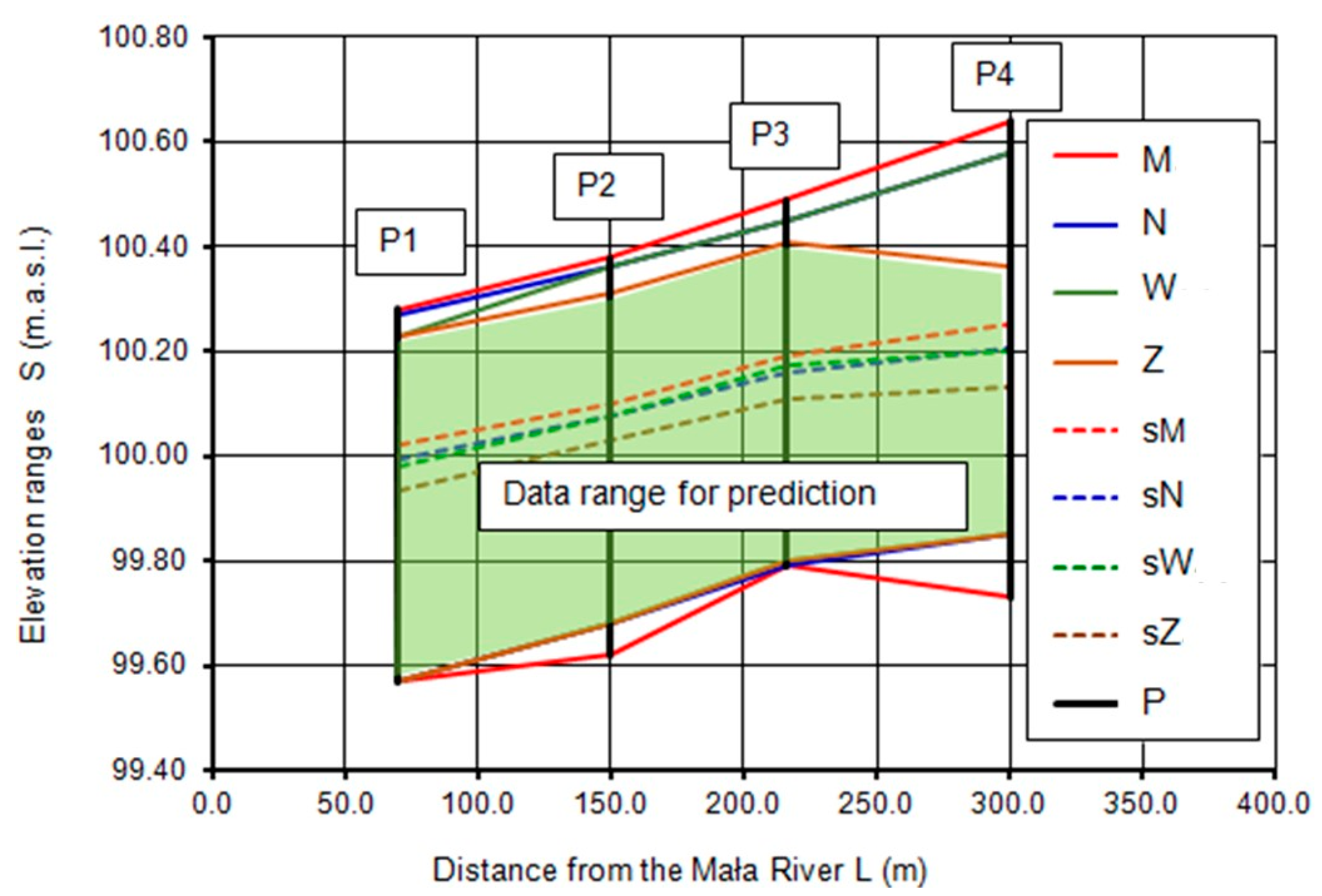
Subsequent stages of the criterial analysis of groundwater elevations showed that extracting measurements without the influence of rainfall from the base dataset M1–4 = 720 data points resulted in a reduction in the range of maximum elevations in the cross-sections (Figure 4). At the same time, the minimum elevations increased, especially in cross-sections P2 and P4. The average elevations underwent minor changes. The implementation of stages E1–4 of the procedure, involving a reduction in rainfall impact, caused the greatest drop in maximum elevation values in cross-section P4, which is located furthest from the river on sandy soils (Figure 4). In this cross-section, measurements that showed the influence of rainfall on groundwater levels were eliminated. Consequently, the indicated criteria identified a dataset for which the proposed linear model is stable in the range of changes in rainfall factors and reacts in a limited way to rainfall directly falling on the site. The internal polygon in Figure 4 indicates the range of elevations for the dataset Z1–4 = 72 used to determine the prediction model.

3.4. Predictive Model

The independence of predictors in Equation (1) was verified based on the Pearson correlation coefficient (rs) (Table 3). A lack of a linear relationship or a weak correlation was observed in the case of six variable pairs. A moderate relationship characterizes two variable pairs, and a fairly strong dependence was found in two pairs.
At the E5 stage of the procedure, the inference about the influence of beaver activity on changes in groundwater levels was based on Equation (1). For this purpose, a simple regression analysis YS = f(Xi) was performed for each of the five selected variables, indicating the impact of beaver activity on the values of groundwater levels in wells. The predicted relationship YS with individual predictors was determined by calculating the parameters of the linear correlation for X1R-29—water levels in the R-29 channel (m.a.s.l.); X2R-27—water levels in the R-27 channel (m.a.s.l.); X3L—distances of channels from the river L (m); X4k—soil filtration coefficients in the cross-section k (m·s−1); and X5Pm—monthly precipitation Pm (mm) (Table 4).
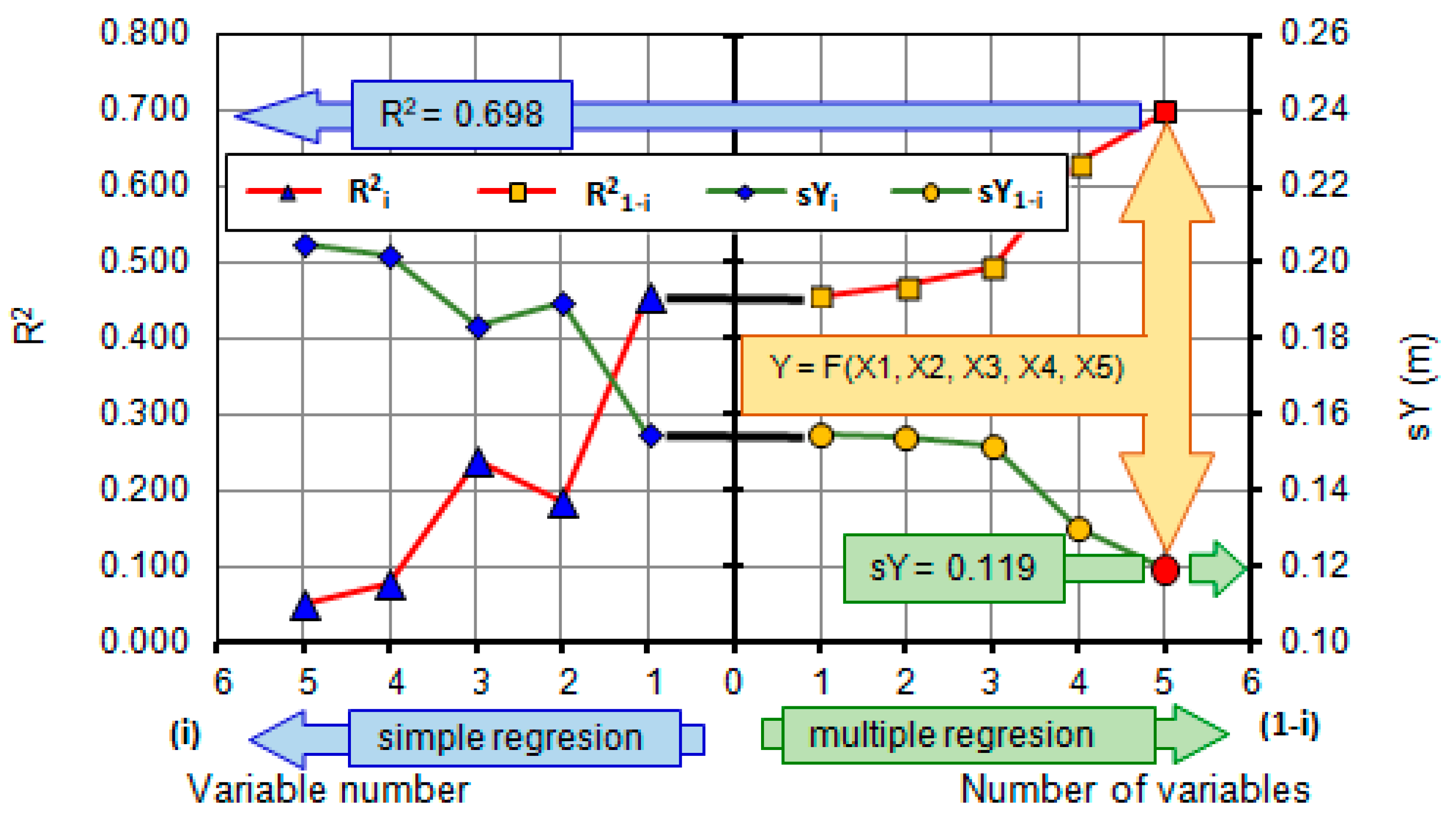
The changes in the obtained statistical values for simple linear regression Y = f(Xi) according to formulas from Equation (2) to Equation (6) in Table 4, illustrating the fit of the regression curve of the linear model, are shown on the left scale of Figure 5. For each analyzed predictor from 1 to 5, the coefficient of determination R2i decreases, while the standard error of the estimation function sYi (m) increases. The best fit is provided by the variable X1R-29 (R2R-29 = 0.457 sYR-29 = 0.155 m). The variable X1 was adopted as the first in the multiple regression analysis.
The changes in the obtained statistical values for multiple linear regression Y = f(X1-i), according to formulas from Equation (7) to Equation (10) in Table 5, are shown on the right scale of Figure 5. With an increasing number of predictors (I ≤ 5), while maintaining their order, the coefficient of determination R21-I increases, and the value of the standard error of the estimation sY1-I decreases. In the final stage of verification, the best fit and the maximum value of the coefficient of determination R2(1–5) = 0.698, and the minimum values of the standard error of the estimation sY(1–5) = 0.119 m were obtained for all I = 5 predictors (Equation (10), Table 5). This equation was used for verification calculations.
The calculated values of groundwater levels in the training set (Z1–4 = 72), calculated using the formula in Equation (10), are shown in Figure 6a. The Nash–Sutcliffe model efficiency coefficient (NSE) for comparing measured data to simulated data from Equation (10) is equal 0.698. The obtained values exhibit a smaller range of maximum values, indicating that the developed prediction model, in accordance with the assumption, models the factor of direct rainfall to a small extent.
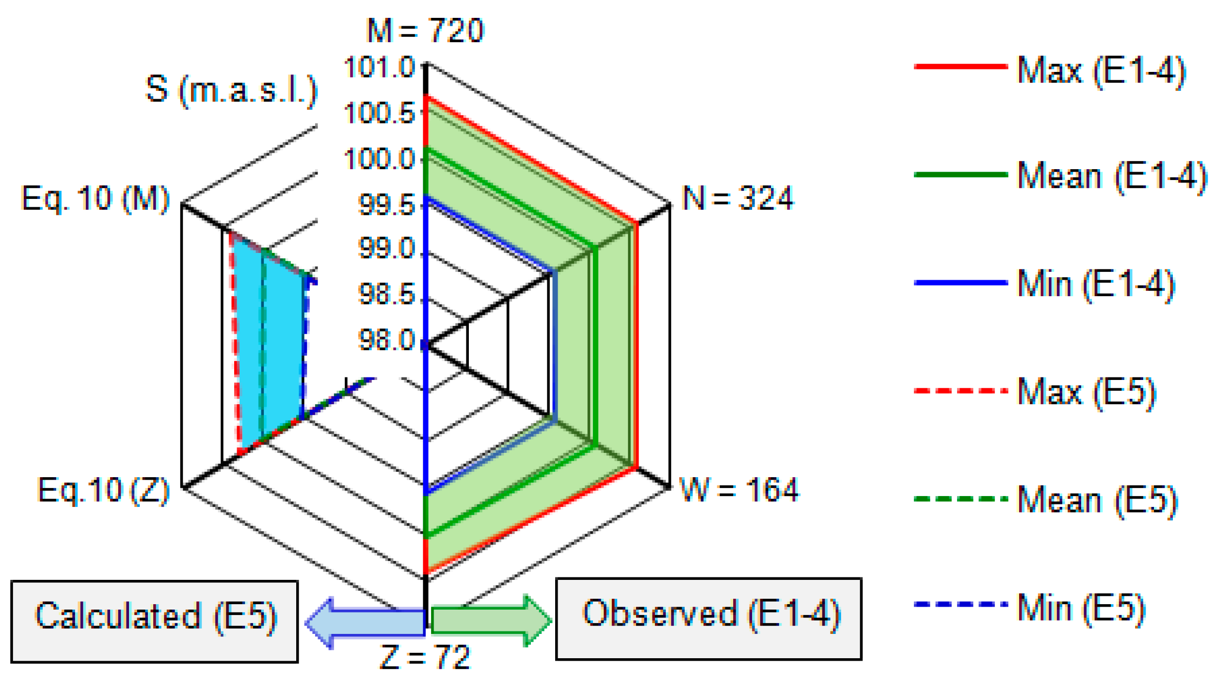
Equation (10) was used to calculate groundwater levels in the wells for all measurements in the basic set M1–4 = 720, including rainy periods (Figure 6b). These values indicate groundwater levels resulting from beaver activity, reduced by the influence of direct rainfall. In Figure 7, the ranges of groundwater level values S (m.a.s.l.) for successive stages of analysis are presented. The groundwater levels calculated in stage E5 according to Equation (10) exhibit a smaller range of changes than the measured groundwater levels analyzed in stages E1–4.
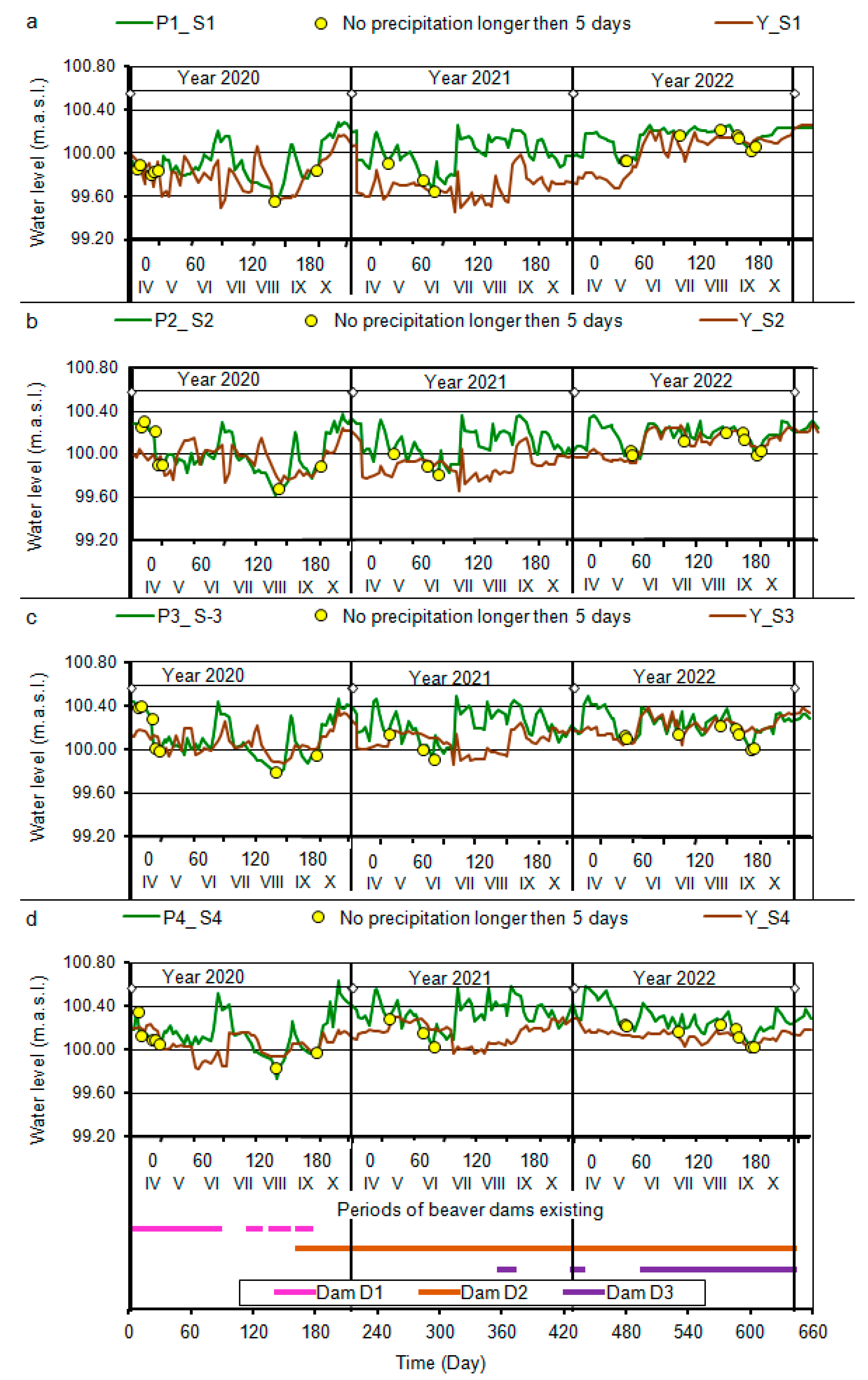
The time analysis of the calculated groundwater levels for the studied cross-sections (Figure 8) indicated that the proposed prediction model accurately reflects the assumptions of the research procedure. During periods of increased rainfall, the calculated levels S (m.a.s.l.) do not respond to direct precipitation falling on the surface of the area. The model is stable to the direct impact of precipitation, and at the same time, the indicated predictor X5Pm effectively describes the periodic influence of beavers. The presented methodology and the obtained Equation (10) can therefore be used to separate groundwater resources originating from precipitation from the amount of water retained above beaver dams.

4. Conclusions

From the conducted research and analysis of their results, the following conclusions have been formulated:
  • The water resources of the Mała River and adjacent ditches were closely related to atmospheric precipitation and the activity of beavers in the analyzed fragment of the drainage system. In 2020, with the highest sum of seven-month precipitation Pm7 = 524.2 mm, beaver activity was determined to be the lowest. In that year, beavers built and maintained a single dam in location D1. The average activity was defined in 2021 with a precipitation sum of Pm7 = 385.5 mm. In that year, beavers moved the dam to location D2 and began building another dam at location D3. The highest activity was observed in 2022 with the lowest precipitation sum of Pm7 = 298.2 mm. In 2022, beavers exploited two dams, namely D2 and D3, maintaining the highest water retention levels (Figure 2).
  • By employing the data standardization method, five significant variables describing the impact of beaver activity on groundwater conditions in the study area were obtained. These variables belong to three groups: ditches, cross-sections, and precipitation. In the ditches group, two variables were identified: X1R-29 (m.a.s.l.), the water level in ditch R-29, and X2R-27 (m.a.s.l.), the water level in ditch R-27, whose temporal variability is shown in Figure 2. The cross-sections group is represented by two parameters: X3L (m), the distance of cross-sections from the Mała River according to Figure 1, and X4k (m·s−1), the filtration coefficient of the active layer of peat soil (kt = 5.2 × 10⁻⁶ m·s−1) and mineral soil (kp = 3.0 × 10⁻⁴ m·s−1). In the precipitation group, one variable was isolated: Pm (mm), the monthly sum of precipitation according to Table 1.
  • The most significant impact on changes in groundwater levels was exerted by water levels in ditches directly adjacent to the study area. Adding successive variables to the linear prediction model increased the coefficient of determination, which, in the final verification stage, reached the value R2(1–5) = 0.698, with a simultaneous reduction in the standard error of estimation to the value sY(1–5) = 0.119 m (Figure 5).
  • The groundwater table elevations in the middle of the study area depended on the water levels in ditches, the distance of cross-sections from the river, the soil filtration coefficient, and monthly rainfall sums affecting beaver activity. All the specified i = 5 predictors showed a significant impact on the final model outcome. Model verification on the training set Z = 72 (points in Figure 8) and the base set M = 720 (lines in Figure 8) demonstrated the stability of the developed model to the direct impact of rainfall. The indicated predictor X5Pm effectively describes the influence of rainfall on seasonal beaver activity.

Author Contributions

Conceptualization, S.B., R.O. and J.J.; methodology, S.B., R.O. and J.J.; software, S.B.; validation, S.B., R.O., J.U. and J.J.; formal analysis, S.B., R.O., J.U., M.K. and J.J.; investigation, R.O.; resources, J.J.; writing—original draft preparation, S.B., R.O., J.U., J.J. and M.K.; writing—review and editing, S.B. and M.K.; visualization, S.B.; supervision, R.O. and J.J. All authors have read and agreed to the published version of the manuscript.

Funding

This research received no external funding.

Institutional Review Board Statement

Not applicable.

Informed Consent Statement

Not applicable.

Data Availability Statement

The data that support the findings of this study are available from the corresponding author, [M.K.], upon reasonable request.

Conflicts of Interest

The authors declare no conflicts of interest.

References

  1. Sojka, M.; Kozłowski, M.; Stasik, R.; Napierała, M.; Kęsicka, B.; Wróżyński, R.; Jaskuła, J.; Liberacki, D.; Bykowski, J. Sustainable water management in agriculture—The impact of drainage water management on groundwater table dynamics and subsurface outflow. Sustainability 2019, 11, 4201. [Google Scholar] [CrossRef]
  2. Crawford, J.C.; Liu, Z.; Nelson, T.A.; Nielsen, C.K.; Bloomquist, C.K. Microsatellite analysis of mating and kinship in beavers (Castor canadensis). J. Mammal. 2008, 89, 575–581. [Google Scholar] [CrossRef]
  3. Boczoń, A.; Wróbel, M.; Syniaiev, V. The impact of beaver ponds on water resources in the catchment area in the Browsk Forest District—A case study. For. Res. Pap. 2009, 70, 363–371. [Google Scholar] [CrossRef]
  4. Pietrek, A.G.; Escobar, J.M.; Fasola, L.; Roesler, I.; Schiavini, A. Why invasive Patagonian beavers thrive in unlikely habitats: A demographic perspective. J. Mammal. 2016, 98, 283–292. [Google Scholar] [CrossRef]
  5. Jones, B.M.; Tape, K.D.; Clark, J.A.; Nitze, I.; Grosse, G.; Disbrow, J. Increase in beaver dams controls surface water and thermokarst dynamics in an Arctic tundra region, Baldwin Peninsula, northwestern Alaska. Environ. Res. Lett. 2020, 15, 075005. [Google Scholar] [CrossRef]
  6. Wróbel, M. Population of Eurasian beaver (Castor fiber) in Europe. Glob. Ecol. Conserv. 2020, 23, e01046. [Google Scholar] [CrossRef]
  7. Brazier, R.E.; Puttock, A.; Graham, H.A.; Auster, R.E.; Davies, K.H.; Brown, C.M.L. Beaver: Nature’s ecosystem engineers. WIREs Water 2021, 8, e1494. [Google Scholar] [CrossRef] [PubMed]
  8. Naiman, R.J.; Johnston, C.A.; Kelley, J.C. Alteration of North American Streams by Beaver. BioScience 1988, 38, 753–762. [Google Scholar] [CrossRef]
  9. Tape, K.D.; Jones, B.M.; Arp, C.D.; Nitze, I.; Grosse, G. Tundra be dammed: Beaver colonization of the Arctic. Glob. Chang. Biol. 2018, 24, 4478–4488. [Google Scholar] [CrossRef]
  10. Połeć, K.; Grzywna, A.; Tarkowska-Kukuryk, M.; Bronowicka-Mielniczuk, U. Changes in the ecological status of rivers caused by the functioning of natural barriers. Water 2022, 14, 1522. [Google Scholar] [CrossRef]
  11. Piętka, S.; Misiukiewicz, W. Impact of European Beaver (Castor fiber L.) on vegetation diversity in protected area river valleys. Conservation 2022, 2, 613–626. [Google Scholar] [CrossRef]
  12. Orazi, V.; Hagge, J.; Gossner, M.M.; Müller, J.; Heurich, M. A biodiversity boost from the Eurasian Beaver (Castor fiber) in Germany’s oldest national park. Front. Ecol. Evol. 2022, 10, 873307. [Google Scholar] [CrossRef]
  13. Stefen, C.; Habersetzer, J.; Witzel, U. Biomechanical aspects of incisor action of beavers (Castor fiber L.). J. Mammal. 2016, 97, 619–630. [Google Scholar] [CrossRef]
  14. Karran, D.J.; Westbrook, C.J.; Wheaton, J.M.; Johnston, C.A.; Bedard-Haughn, A. Rapid surface-water volume estimations in beaver ponds. Hydrol. Earth Syst. Sci. 2017, 21, 1039–1050. [Google Scholar] [CrossRef]
  15. Ilnicki, P. Mit Stepowienia Wielkopolski w Świetle Wieloletnich Badań Obiegu Wody = Myth of the Steppe Forming Process in the Wielkopolska Region from the Viewpoint of Long Investigations of Water Circulation; Wydawnictwo Uniwersytetu Przyrodniczego: Poznań, Poland, 2012. [Google Scholar]
  16. Oleszczuk, R.; Jadczyszyn, J.; Gnatowski, T.; Brandyk, A. Variation of moisture and soil water retention in a lowland area of central Poland—Solec site case study. Atmosphere 2022, 13, 1372. [Google Scholar] [CrossRef]
  17. Somorowska, U. Amplified signals of soil moisture and evaporative stresses across Poland in the twenty-first century. Sci. Total Environ. 2022, 812, 151465. [Google Scholar] [CrossRef] [PubMed]
  18. Gamborg, C.; Sandøe, P. Beavers and Biodiversity: The Ethics of Ecological Restoration. In Philosophy and Biodiversity; Okksanen, M., Ed.; Cambridge University Press: New York, NY, USA, 2004. [Google Scholar] [CrossRef]
  19. Collen, P.; Gibson, R.J. The general ecology of beavers (Castor spp.), as related to their influence on stream ecosystems and riparian habitats, and the subsequent effects on fish—A review. Rev. Fish Biol. Fish. 2000, 10, 439–461. [Google Scholar] [CrossRef]
  20. Johnston, C.; Windels, S. Using beaver works to estimate colony activity in boreal landscapes. J. Wildl. Manag. 2015, 79, 1072–1080. [Google Scholar] [CrossRef]
  21. Hodkinson, I. Energy flow and organic matter decomposition in an abandoned beaver pond ecosystem. Oecologia 1975, 21, 131–139. [Google Scholar] [CrossRef]
  22. Ulloa, E.; Anderson, C.; Ardón, M.; Murcia, S.; Valenzuela, A. Organic matter characterization and decomposition dynamics in sub-Antarctic streams impacted by invasive beavers. Lat. Am. J. Aquat. Res. 2017, 40, 881–892. [Google Scholar] [CrossRef]
  23. Brandyk, A.; Kaca, E.; Oleszczuk, R.; Urbański, J.; Jadczyszyn, J. Conceptual model of drainage-sub irrigation system functioning-first results from a case study of a lowland valley area in central Poland. Sustainability 2020, 13, 107. [Google Scholar] [CrossRef]
  24. Čiuldienė, D.; Vigricas, E.; Belova, O.; Aleinikovas, M.; Armolaitis, K. The effect of beaver dams on organic carbon, nutrients and methyl mercury distribution in impounded waterbodies. Wildl. Biol. 2020, 2020, 1–8. [Google Scholar] [CrossRef]
  25. Darzi, A.; Ejlali, F.; Ahmadi, M.; Najfi, G.H. The suitability of controlled drainage and subirrigation in paddy fields. Pak. J. Biol. Sci. 2007, 10, 492–497. [Google Scholar] [CrossRef]
  26. Szejba, D.; Bajkowski, S. Determination of tile drain discharge under variable hydraulic conditions. Water 2019, 11, 120. [Google Scholar] [CrossRef]
  27. Bajkowski, S.; Urbański, J.; Oleszczuk, R.; Siwicki, P.; Brandyk, A.; Popek, Z. Modular regulators of water level in ditches of subirrigation systems. Sustainability 2022, 14, 4103. [Google Scholar] [CrossRef]
  28. Hämmerling, M.; Kałuża, T.; Zawadzki, P.; Zaborowski, S.; Sojka, M.; Liberacki, D.; Ptak, M. Application of multi-criteria analytic methods in the assessment of the technical conditions of small hydraulic structures. Buildings 2022, 12, 115. [Google Scholar] [CrossRef]
  29. Nowak, B.; Ptak, M.; Bartczak, J.; Sojka, M. Hydraulic structures as a key component of sustainable water management at the catchment scale—Case study of the Rgilewka River (Central Poland). Buildings 2022, 12, 675. [Google Scholar] [CrossRef]
  30. Urbański, J.; Bajkowski, S.; Siwicki, P.; Oleszczuk, R.; Brandyk, A.; Popek, Z. Laboratory tests of water level regulators in ditches of irrigation systems. Water 2022, 14, 1259. [Google Scholar] [CrossRef]
  31. Abduljaleel, Y.; Awad, A.; Al-Ansari, N.; Salem, A.; Negm, A.; Gabr, M.E. Assessment of subsurface drainage strategies using drainmod model for sustainable agriculture: A review. Sustainability 2023, 15, 1355. [Google Scholar] [CrossRef]
  32. Boico, V.F.; Therrien, R.; Delottier, H.; Young, N.L.; Højberg, A.L. Comparing alternative conceptual models for tile drains and soil heterogeneity for the simulation of tile drainage in agricultural catchments. J. Hydrol. 2022, 612, 128120. [Google Scholar] [CrossRef]
  33. He, J.; Hou, X.-L.; Wang, W. Study of water quality pollution index, land-use and socio-economic factors in Yingkou irrigation district of China based on redundancy analysis. Nat. Environ. Pollut. Technol. 2022, 21, 297–302. [Google Scholar] [CrossRef]
  34. Bykowski, J. (Ed.) Współczesne Uwarunkowania i Wyzwania Gospodarowania Wodą w Rolniczej Przestrzeni Produkcyjnej Wielkopolski, 1st ed.; Wydawnictwo Uniwersytetu Przyrodniczego w Poznaniu: Poznań, Poland, 2021. (In Polish) [Google Scholar]
  35. Ilnicki, P.; Górecki, K.; Szczepański, M. Accelerated peatland disappearance in the vicinity of the Konin brown coal strip mine. J. Water Land Dev. 2017, 35, 83–93. [Google Scholar] [CrossRef]
  36. Environment 2022. Statistical Analyses. Statistics Poland (GUS), Spatial and Environmental Surveys Department. Warsaw. 2022. ISSN 0867-3217. Available online: https://stat.gov.pl (accessed on 13 May 2024).
  37. Lenartowicz, M. Charakterystyka Hydrologiczna Chojnowskiego Parku Krajobrazowego in Chojnowski Park Krajobrazowy Monografia Przyrodniczo-Edukacyjna; Zespół Parków Krajobrazowych Mazowieckiego, Chojnowskiego i Brudzeńskiego: Otwock, Poland, 2007. (In Polish) [Google Scholar]
  38. Brandyk, T. Podstawy Regulowania Uwilgotnienia Gleb Dolinowych. Rozprawy Naukowe i Monografie nr 116; Warsaw University of Life Sciences: Warsaw, Poland, 1990. (In Polish) [Google Scholar]
  39. Brandyk, A.; Oleszczuk, R.; Urbański, J. Estimation of organic soils subsidence in the vicinity of hydraulic structures—Case study of a subirrigation system in central Poland. J. Ecol. Eng. 2020, 21, 64–74. [Google Scholar] [CrossRef] [PubMed]
  40. Kaca, E. Model Matematyczny Procesu Podnoszenia Się Zwierciadła Wody Gruntowej Przy Nawodnieniu Podsiąkowym. Doctoral Thesis, Warsaw University of Life Sciences, Warsaw, Poland, 11 July 1981. (In Polish). [Google Scholar]
  41. Gąsowska, M. Wpływ Zmian Sposobu Użytkowania Łąk Na Fizyko-Wodne Właściwości Gleb Organicznych Na Przykładzie Obiektu Łąki Soleckie. Doctoral Thesis, Warsaw University of Life Sciences, Warsaw, Poland, 11 July 2018. (In Polish). [Google Scholar]
  42. Prochal, P. Podstawy Melioracji Rolnych; Państwowe Wydawnictwo Rolnicze i Leśne: Warsaw, Poland, 1986; p. 620. [Google Scholar]
Figure 1. Map of the development of the research facility area: (a)—year 2001.06, (b)—year 2011.05, (c)—year 2020.08, (d)—year 2022.07, (e)—PLH140055 Łąki Soleckie, (f)—research quarter.
Sustainability 16 04135 g001
Figure 2. Elevation of water levels in ditches and wells in cross section: (a)—P1, (b)—P2, (c)—P3, (d)—P4. Pd—daily precipitation (mm), Pp—periodic precipitation (mm).
Sustainability 16 04135 g002
Figure 3. Groundwater level S1–4 relation to the surface water in ditches R-29 and R-27 for measurements: (a)—M1–4 = 720 data, (b)—without precipitation for existing dams N1–4 = 324 data, (c)—without periodic precipitation W1–4 = 164 data, (d)—5 days or more without precipitation Z1–4 = 72 data.
Sustainability 16 04135 g003
Figure 4. Ranges of the groundwater levels S for cross sections: M… Z—maximum and minimum elevations in sections; sM… sZ—average elevations in sections; P—cross section.
Sustainability 16 04135 g004
Figure 5. Statistics of the linear simple and multiple regression function according to Equation (1): R2—determination coefficient; sY—standard error of the estimate.
Sustainability 16 04135 g005
Figure 6. Calculated according to Equation (10), groundwater levels S (m.a.s.l.) relation to the surface water in ditches R-29 and R-27: (a)—Z1–4 = 72 data; (b)—M1–4 = 720 data.
Sustainability 16 04135 g006
Figure 7. Ranges of the groundwater levels for procedure stages: E1–4—stages of data analysis; E5—model verification stage according to Equation (10). Max—maximum; Min—minimum; Mean—average value.
Sustainability 16 04135 g007
Figure 8. Measured (Si) and calculated (Y_Si) groundwater level in wells in cross section: (a)—P1, (b)—P2, (c)—P3, (d)—P4. P1_S1, P2_S2, P3_S3, P4_S4—measured groundwater level in cross sections; Y_S1, Y_S2, Y_S3, Y_S4—calculated groundwater levels in cross sections according to Equation (10).
Sustainability 16 04135 g008
Table 1. Precipitation conditions for the measurement period.
No.StageDescription of Measurements and CriteriaYearTotal
202020212022SeriesData
12345678
1E1Days of the observation period214214214 642
2No precipitation days10595107 307
3M—number of measurements626058180720
5E2No. precipitation measurements28253487348
6N—no precipitation with dams22253481324
7E3W—no preceding precipitation11121841164
8E4Z—no precipitation 5 days before7381872
9 Pm7—over 7 months precipitation524.2385.5298.2
10 Over 7 months average daily precipitation 2.451.801.39
Table 2. Values of the predictor X5Pm monthly precipitation Pm (mm).
No.MonthYear
202020212022
12345
1IV7.765.140.5
2V79.517.741.4
3VI16031.933.3
4VII42.9118.968.5
5VIII77.093.740.5
6IX62.947.642.6
7X94.210.631.4
Table 3. Pearson’s correlation coefficient (rs) test of independence of predictors.
No.XiX1R-29X2R-27X3LX4kX5PmCorrelation Level
123456789
1X1R-291.00 |rs| < 0.2no connection
2X2R-270.751.00 0.2 ≤ |rs| < 0.4weak
3X3L0.480.091.00 0.4 ≤ |rs| < 0.7moderate
4X4k0.560.200.801.00 0.7 ≤ |rs| < 0.9quite strong
5X5Pm0.040.030.000.001.00|rs| ≥ 0.9very strong
Table 4. Parameters of the linear simple regression function according to Equation (1).
No.Xim1m2m3m4m5BEquation
1(1)0.887000011.417(2)
2(2)00.46000054.138(3)
3(3)001.23 × 10−30099.812(4)
4(4)0004.535 × 102099.997(5)
5(5)0000−2.247 × 10−3100.110(6)
Table 5. Parameters of the linear multiple regression function according to Equation (1).
No.X(1-i)m1m2m3m4m5BR2sYEquation
1(1-1)0.887000011.4170.4570.155(2)
2(1-2)1.052−0.179400012.8330.4700.154(7)
3(1-3)0.806−0.04864.929 × 10−40024.2820.4940.152(8)
4(1-4)1.073−0.11131.524 × 10−3−1.052 × 10303.7400.6320.130(9)
5(1-5)1.104−0.11961.514 × 10−3−1.066 × 10³−2.577 × 10−31.5770.6980.119(10)
Disclaimer/Publisher’s Note: The statements, opinions and data contained in all publications are solely those of the individual author(s) and contributor(s) and not of MDPI and/or the editor(s). MDPI and/or the editor(s) disclaim responsibility for any injury to people or property resulting from any ideas, methods, instructions or products referred to in the content.