Article

Environmental Unsustainability in Cartagena Bay (Colombia): A Sentinel-3B OLCI Satellite Data Analysis and Terrestrial Nanoparticle Quantification

by
Alcindo Neckel
1,*,
Manal F. Abou Taleb
2,
Mohamed M. Ibrahim
3,
Leila Dal Moro
1,
Giana Mores
1,*,
Guilherme Peterle Schmitz
1,
Brian William Bodah
4,5,
Laércio Stolfo Maculan
1,
Richard Thomas Lermen
1,
Claudete Gindri Ramos
6 and
Marcos L. S. Oliveira
6,7
1
ATITUS Educação, Passo Fundo 99070-220, Brazil
2
Department of Chemistry, College of Science and Humanities in Al-Kharj, Prince Sattam Bin Abdulaziz University, Al-Kharj 11942, Saudi Arabia
3
Department of Chemistry, College of Science, Taif University, P.O. Box 11099, Taif 21944, Saudi Arabia
4
Thaines and Bodah Center for Education and Development, 840 South Meadowlark Lane, Othello, WA 99344, USA
5
Workforce Education & Applied Baccalaureate Programs, Yakima Valley College, South 16th Avenue & Nob Hill Boulevard, Yakima, WA 98902, USA
6
Department of Civil and Environmental Engineering, Universidad de la Costa, CUC, Calle 58 # 55–66, Barranquilla 080002, Colombia
7
Santa Catarina State Research and Innovation Support Foundation, FAPESC, Florianópolis 88030-902, Brazil
*
Authors to whom correspondence should be addressed.
Sustainability 2024, 16(11), 4639; https://doi.org/10.3390/su16114639
Submission received: 21 March 2024 / Revised: 13 May 2024 / Accepted: 28 May 2024 / Published: 30 May 2024

Abstract

:
Human actions that modify terrestrial and aquatic environments contribute to unsustainability, influencing the economy and human health. Urban environments are responsible for the dispersion of pollution and nanoparticles (NPs), which can potentially harm the health of human populations and contaminate the fauna and flora of aquatic ecosystems on a global scale. The objective of this study is to analyze the dissemination of nanoparticles in Cartagena Bay, Colombia, during the strong winds/low runoff season of January 2020 and the weak winds/high runoff season of October 2021. This was accomplished using images from the Sentinel-3B OLCI (Ocean Land Color Instrument) satellite in conjunction with an analytical chemical analysis of sediments collected in the study area in a laboratory with advanced electron microscopy. It was possible to obtain, on average, a sample of suspended sediments (SSs) every 1000 m in the areas of Bocagrande, Isla de Tierra Bomba, and Playa Blanca, which were analyzed in the laboratory with X-ray diffraction (XRD) and electron transmission and scanning microscopies. Images obtained in the summer of 2020 and winter of 2021 by the Sentinel 3B OLCI satellite were selected at a distance of 1 km from each other and analyzed for the following variables: chlorophyll (CHL_NN), water turbidity (TSM_NN), and suspended pollution potential (ADG443_NN). In addition to of evaluating georeferenced maps, they were subjected to an analysis within the statistical and K-Means clustering model. The laboratory analysis of SSs showed the presence of potentially toxic NPs, responsible for contamination that may harm the health of the local population and marine ecosystems. The K-Means and satellite image analysis corroborated the laboratory analyses, revealing the source of the pollution and contamination of Cartagena Bay as the estuary located close to its center.

1. Introduction

The anthropogenic pollution of rivers and oceans causes contamination in hydrological reservoirs by dangerous elements present in sediments in the form of nanoparticles (NPs) and ultrafine particles that may contain harmful chemical elements, degrading the sustainability of the environment [1]. This contamination can compromise human health and sustainability of aquatic biodiversity globally [1,2]. Therefore, the need for studies to identify the types of pollutants present in water resources is highlighted. This makes it possible to formulate policies to mitigate environmental pollution caused by dangerous chemical elements added to NPs [3,4,5]. It is important to remember that hazardous chemical elements are defined by their toxicity to human health and the environment, regardless of concentration levels [6,7].
When considering toxic chemical elements in NPs and ultrafine particles, other studies [1,2,5,8] demonstrate concerns regarding the high proportions of dangerous elements in aquatic environments. This contamination results from atmospheric pollution from leachate, industrial contamination, and a lack of adequate treatment of urban and rural waste released into water sources. Neckel et al. [1], when evaluating the dangerous elements aggregated in NPs resulting from anthropogenic impacts arising from coal mining activities in the southern region of Brazil, agricultural pesticides, swine farming, and the release of effluents into water resources, demonstrated through X-ray diffraction (XRD) elevated amounts of arsenic, lead, chromium, and mercury present in NPs in the beds of water bodies.
Fortes et al. [2], when analyzing sedimentable atmospheric particulate matter (SeAPM) by XRD to identify chemical elements present in sediments, demonstrated a high potential for contamination in aquatic environments by arsenic, lanthanum, zirconium, and mercury when added to NPs. Souza et al. [5], when studying the type of chemical contamination aggregated in NPs from steel industries, detected through XRD a high level of chromium, copper, and titanium capable of directly reaching water sources due to the lack of adequate treatment of leachate generated during the industrial process. Silva et al. [8], when studying NPs containing dangerous chemical elements generated by industrial processes, the exploration for mineral coal and phosphogypsum, and the lack of adequate treatment of urban effluents, found a high presence of arsenic, lead, mercury, niobium, nickel, and vanadium in NPs analyzed with XRD.
The European Space Agency (ESA) launched the Sentinel-3B OLCI (Ocean Land Color Instrument) into space on 16 February 2016, to contribute to terrestrial surveys capable of quantifying the levels of dangerous chemical elements present in NPs [9,10,11]. This makes it possible to understand the dynamics of chlorophyll-a displacement (CHL_NN), water turbidity (TSM_NN), and suspended pollution potential (ADG_443_NN) containing NPs and ultrafine particles responsible for the transport of dangerous elements across large regions [1,9,10,11]. Consequently, chlorophyll-a levels, when detected in Sentinel-3B OLCI images, help us to understand the quantitative dynamics of pigments that represent plant tissues or the high proportion of algae and phytoplankton capable of obstructing the passage of sunlight in water and resulting in eutrophication. This problem is aggravated by the high accumulation potential of chemical elements in NPs in aquatic sediments [12,13].
In this relationship, turbidity and the potential for suspended water pollution are associated with hydrological quality. Considering the comprehensive detection parameters via the Sentinel-3B OLCI satellite’s optics, it is possible to understand the turbidity coefficients and absorption of total suspended matter in aquatic environments [14,15]. According to Neckel et al. [1] and Li et al. [15], aquatic ecosystems contribute to the flow of sediments into rivers. This process, aggravated by the irrigation process and industries, has the potential to release high levels of dangerous chemical elements coupled with NPs into aquatic environments. This negatively affects the hydrological quality of these water bodies by increasing turbidity levels and the potential for suspended pollution, which can be seen by remote sensing via the Sentinel-3B OLCI satellite. This makes it possible to collect geospatial data associated with the quality of a water resource.
It is important to highlight that data collection through images from the Sentinel-3B OLCI satellite is configured as an advanced and robust tool for the geospatial assessment of environmental impacts on chlorophyll-a (CHL_NN), water turbidity (TSM_NN), and the potential of suspended pollution (ADG_443_NN) in surface water bodies, such as rivers, lakes, bays, and oceans in large regions [16]. This enables a greater understanding of the dispersion dynamics of NPs and ultrafine particles in sediments, which may contain dangerous chemical elements when detected via XRD. These can move through aquatic environments influenced by the speed of water flow or the intensity of marine currents. These elements can increase water toxicity in large regions [16,17,18].
Contamination in hydrological environments by dangerous chemical elements compromises the survival of several species of aquatic fauna and flora and directly affects local sustainability, as there are local fishermen who depend on fishing as a means of family subsistence [8,19]. When these types of chemical contaminants are identified in sediments through analysis via XRD and in their range of large-scale displacement through images from the Sentinel-3B OLCI satellite, it becomes possible to create public policies capable of mitigating environmental pollution and raise sustainability levels on macroscales [8,20,21].
This study is justified by the need to quantitatively detect the type of dangerous elements attached to sediments in Cartagena Bay, located in the city of Cartagena, Colombia. This is due to its economic importance for the Colombian population. Solid wastes and effluents are released into the bay via numerous industries, areas of agricultural and livestock use, and the increase in the number of tourists who visit the Mar do Sul daily, increasing the degree of environmental pollution in the waters of Cartagena Bay [22,23]. As having occurred throughout most of the world, the operations of the city of Cartagena were interrupted during 2020 due to restrictions imposed by the COVID-19 pandemic, only resuming in 2021 [24].
Wang et al. [25] and Pommier [26] suggest that studies involving satellites coupled with terrestrial sampling from the perspective of environmental geochemistry address data detection on a global scale. We must recognize the period of restrictions on the functioning of cities between 2020 and 2021 due to the COVID-19 pandemic, as well as the post-opening period of cities, with the easing of these restrictions aimed at controlling travel, industrial activities, non-emergency services, and tourism. This temporal variation (from 2020 to 2021), suggested for satellite studies and terrestrial applications from the perspective of geochemistry [25,26], makes it possible to observe water pollution by dangerous chemical elements, highlighting the emerging importance of studies capable of supporting the creation of sustainable public mitigation policies by bodies responsible for maintaining the quality of aquatic environments at a global level [1,27,28,29].
The main objective of this study is to detect, using images from the Sentinel-3B OLCI satellite, the behavior patterns of chlorophyll-a (CHL_NN) in units of m−3, water turbidity (TSM_NN) in units of g m−3, and suspended pollution potential (ADG_443_NN) in units of 443 m−1, in addition to quantifying the dangerous chemical elements present in NPs and ultrafine particles deposited in the sediments of Cartagena Bay (Colombia), in the period comprising the summer and winter seasons of 2020 and 2021. This study is expected to contribute to information that enables and/or complements the creation of future public policies aimed at impacts on aquatic environments in Colombia and other countries. Additionally, by collaborating with the use of new technologies made available by the ESA for assessment, aimed at assessing environmental quality through the detection of satellite information, they contribute to the creation of actions to preserve aquatic ecosystems with a greater degree of sustainability at a global level.

2. Materials and Methods
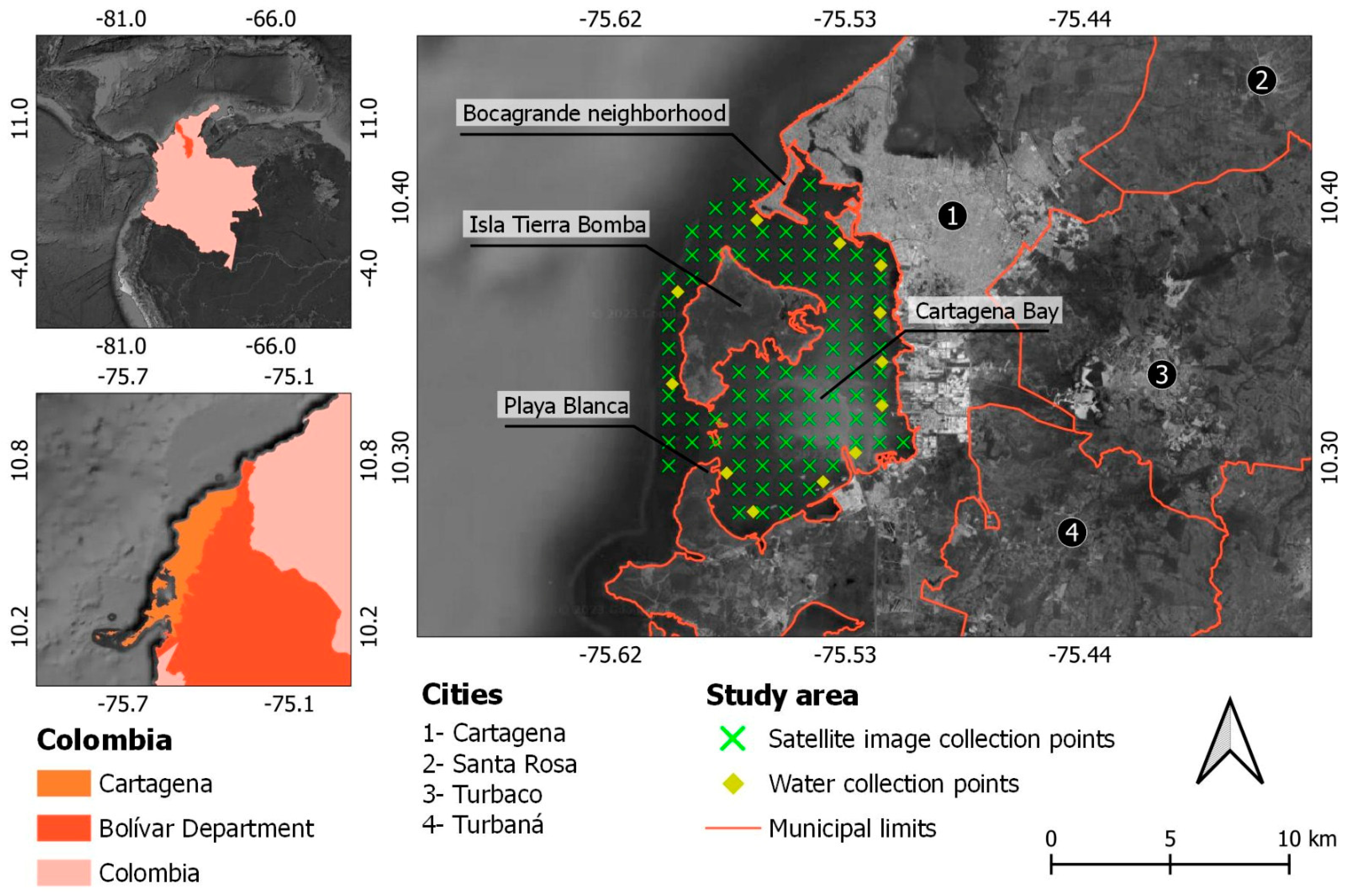
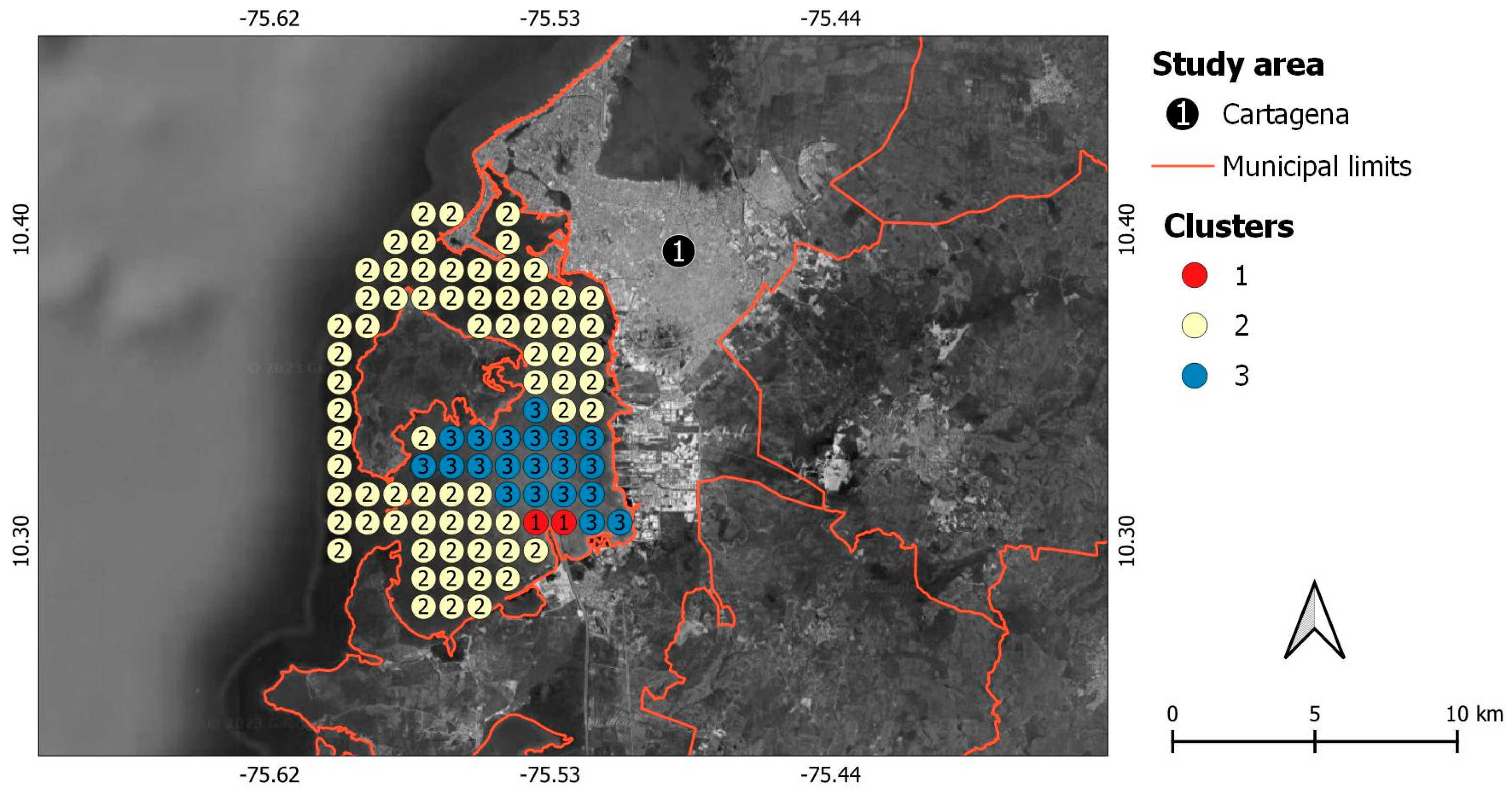
2.1. Study Area

The study area of this research is Cartagena Bay, Colombia, which encompasses the regions of Bocagrande, Isla Tierra Bomba, and Playa Blanca (Figure 1). This area had an estimated 2021 population of 1,043,926 inhabitants [30]. Cartagena Bay is characterized by a humid tropical climate, with relatively high average annual temperatures of around 28 °C, in addition to an average monthly precipitation of 20.2 mm, in an area totaling 85.72 km2 [8,30]. Cartagena has three seasons throughout the year: strong winds/low runoff (January–April), weak winds/intermediate runoff (May–August), and weak winds/high runoff (September–December) [23,29,31,32].
Although the Colombian Caribbean region displays the typical crystalline color of its waters, pollution and contamination from highly polluting sources, such as coal extraction and transport to the port of Cartagena; the incineration of urban waste, a cultural disposition leading to relatively high rates of litter and lackadaisical efforts; ineffective waste management; livestock activities; and the use of agricultural pesticides and industrial activities on the shores of Cartagena Bay, raise concerns among Colombian governments [8,33,34]. For these reasons, and because it is one of the most industrialized Caribbean areas, this study seeks to deepen scientific knowledge about the contaminants in the area under study.
The study area’s soil characteristics are clayey, containing dispersive clays, and highly erosive due to natural precipitation. This can cause a high accumulation of sediment in the waters of the Cartagena Basin [35]. According to Neckel et al. [36], sediments are capable of coupling dangerous chemical elements in the form of NPs and ultrafine particles, which is highly harmful to human health and aquatic fauna and flora, in addition to compromising the livelihood of local fishermen and threatening tourist activities.
Cartagena is a tourist city driven by its historical buildings from the medieval period, Cartagena Bay, and the Caribbean Sea. Approximately 4.5 million tourists visit annually [8,30]. Consequently, Cartagena Bay is recognized as one of Colombia’s leading tourist destinations. Therefore, environmental conservation becomes essential to ensure that the local population continues to enjoy Cartagena Bay and that the tourist market in Cartagena is not suppressed [31,32].

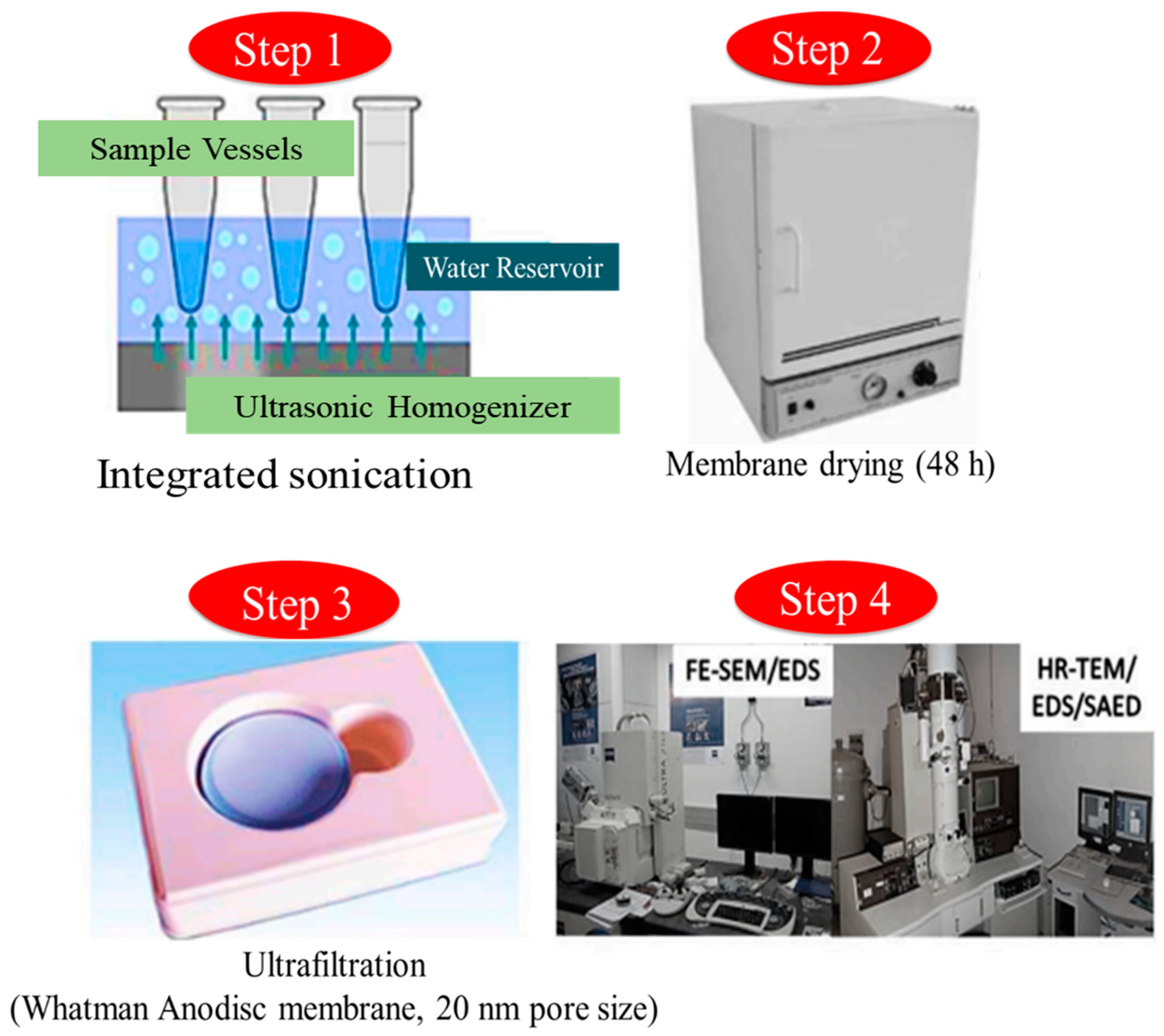
2.2. Procedures for Collecting and Analyzing Sampled Sediments

Samples of sedimentary material from the bottom of the waters of Cartagena Bay were collected at 12 collection points in the regions of Bocagrande, Isla Tierra Bomba, and Playa Blanca using the Draga Van Veen collector. The samples were obtained at an approximate distance of 200 m from the bank, with a minimum spacing of 1000 m between each point [36,37], during January (summer season) and October (winter season) of 2020 and 2021. Cartagena Bay (Figure 1) is highly frequented annually by tourists worldwide [38]. Four collections were carried out at each of the 12 points, totaling 48 collections throughout 2020 and 2021.
Samples of sedimented material totaling 100 mL in volume were added to Niskin bottles and stored in Styrofoam boxes, following the collection standard determined by Graca et al. [38]. Samples were submitted for analysis to the Analytical and Environmental Chemistry laboratory at Universidad de la Costa in Colombia. Before carrying out the analyses, all laboratory equipment, together with the glassware used, went through a manual washing process using Milli-Q water filtered by an ultrapure organic solvent and inorganic membrane (Whatman Anodisc at 20 nm), intending to avoid contamination by external impurities concerning the sampled (homogenized) material [39]. After drying the samples, the material was subjected to HR-TEM (high-resolution transmission electron microscopy) (New York, USA) and FE-SEM (field emission scanning electron microscopy) (New York, USA) analyses (Figure 2), which enabled the quantitative identification of the types of major chemical elements present in the sampled material [36].
High-resolution use of HR-TEM (JEOL-2010F, 200 keV) coupled to a ray scanning detector in an Oxford energy dispersive pattern (STEM) and EDS (energy dispersive X-ray microanalysis) was utilized to determine the chemical elements present in particles <100 nm [36]. The crystalline phases in the sedimented material were determined using XRD, allocated to a Siemens diffractometer (BRUKER AXS) (model D-5000 (θ-θ)). The XRD analysis was performed based on reported previous works [1,36]. Neckel et al. [1] emphasize that identifying the type of chemical elements present in a sampled material, together with a satellite image analysis, allows for an understanding of where the displacement of sediments occurs in the water. Water movement through the action of currents is then capable of dispersing chemical elements over large regions.

2.3. Using Satellite Images to Collect Geospatial Data

In addition to on-site sample collection, this study also includes data collection via the Sentinel-3B OLCI satellite, divided into two main steps [40,41]. The first step involves locating collection points in Cartagena Bay during the high winds/low runoff season (summer) 2020. The satellite data were detected at 3:15 p.m. on January 19th. The second image stage occurred during the low wind/high runoff season (winter) of 2021, and satellite data sampling was also carried out at 3:06 p.m. on October 26th. Qualifying Sentinel-3B OLCI images were required to be free of cloud cover, as per [1,16,40,41].
Sentinel-3B OLCI satellite images used in this study present reflectance in a Neural Network (NN) with a spatial resolution of 300 m. They were normalized by ESA [9,10,11] to a reflectance of 0.83 µg/mg. Furthermore, they consider a maximum spectral error of 6.62%, aiming to detect the quantitative levels of concentrations of CHL_NN (m−3), TSM_NN (g m−3), and ADG_443_NN (443 m−1) during the analyzed period (2020 to 2021).
After selecting images from the Sentinel-3B OLCI satellite, the criteria for determining the sampled points for collecting information in the waters of Cartagena Bay were based on geospatial distribution in a Triangular Irregular Network (TIN) [42,43]. Forming an irregular mesh containing 91 collection points spaced 1000 m apart was possible. These points were distributed in the regions of Bocagrande, Isla Tierra Bomba, and Playa Blanca in Cartagena Bay, using SNAP software (Sentinel Application Platform/version 8.0.4.).
The data collected from Sentinel-3B OLCI satellite images at the 91 sample points were organized in a data spreadsheet. K-Means clustering algorithms were used to perform quantitative analyses utilizing JASP software (Jeffreys’s Amazing Statistics Program), version 3.16.7 [12,44]. This clustering algorithm is an unsupervised technique that identifies similarities between data collected from satellite images, grouping them into clusters and allowing for the identification of hidden structures within the data sets [12,44]. The method works iteratively, starting with an initial solution that can be a random configuration of interaction between the cluster centroids [45]. This iterative process between the cluster centroids continues until the values are smaller than the cluster mean threshold [46,47].
The cluster centroid data were used to calculate the Silhouette index, which evaluates the homogeneity within each cluster individually and compares them with other clusters [46,47]. When the Silhouette index produces values closer to the upper limit of 1, this indicates greater reliability in the cluster data. Silhouette scores closer to the lower limit of −1 indicate inaccuracy in the cluster data [44,48].
The relationship between the uses of sediment samples collected in the field, despite covering local analysis coverage, helps to accurately reveal the type of chemical elements present in the samples [1,12,37]. These dangerous chemical elements are transported by water currents, where satellite image sampling becomes essential, enabling a macroscale analysis of the quantitative dynamics of these chemical elements coupled in the sediments dispersed in the water [1,12,37].

3. Results and Discussion

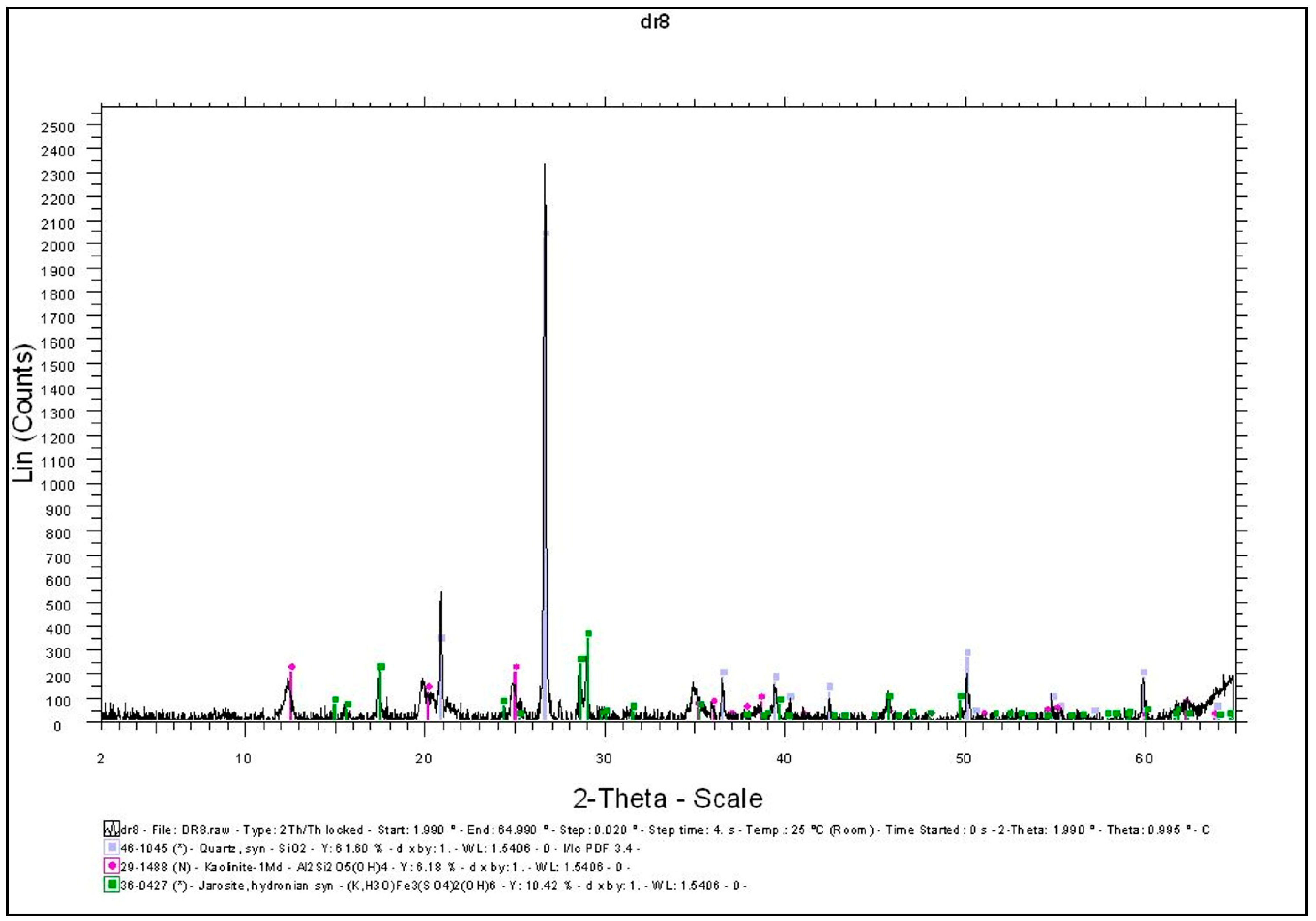
3.1. Laboratory Analysis of the Sampled Sedimented Material

Through samples of sedimentary material collected at 12 specific points in Cartagena Bay, in the regions of Bocagrande, Isla Tierra Bomba, and Playa Blanca, it was possible to determine quantitatively the chemical elements present in 1343 identified NPs and ultrafine particles. In this context, the quantitative identification of chemical elements in NPs becomes of fundamental importance so that governments and public managers can define future policies aimed at preserving hydrological sources and mitigating preserve hydrological sources and mitigate the number of chemical elements that generate large-scale water pollution [1,36,49].
The studied regions of Bocagrande, Isla Tierra Bomba, and Playa Blanca in Cartagena Bay present chemical elements harmful to human health and the aquatic environment associated with the NPs in the analyzed material. The XRD results demonstrated that quartz and kaolinite are the most abundant found in the samples collected in this study (Figure 3). In the areas of Bocagrande and Isla Tierra Bomba, a high degree of plastic particles was identified, which are related to carbon nanotubes with characteristics of fullerenes (Figure 4). According to Kohrs et al. [50], fullerenes consist of spheroidal-shaped nanomolecules capable of incorporating carbon atoms into their structure. On the other hand, in the Playa Blanca region, the sampled material did not reveal chemical contaminants at high levels.
Based on electron microscopy results, the presence of multiple fibers associated with plastics and chemical elements was verified. During the HR-TEM analysis, when a vacuum was applied, the displacement of agglomerated chemical elements was observed without identifying the fibers’ absorption capacity of these elements (Figure 4).
In Figure 5, the presence of significant elements can be observed. Aluminum (Al), iron (Fe), magnesium (Mg), and sodium (Na), among others, were found deposited as nanominerals (Table 1). The use of FIB-SEM in this study is justified by the ability to cut agglomerates with large sizes, which allows for an understanding of their internal structures. This allowed the detection of minerals present in the analyzed structures and the identification of their amorphous phases in microstructures. According to Silva et al. [51] and Oliveira et al. [52], identifying chemical elements in structures smaller than 10 µm is innovative, as it allows for better quantitative identification in structures such as NP nanoparticles and ultrafine particles.

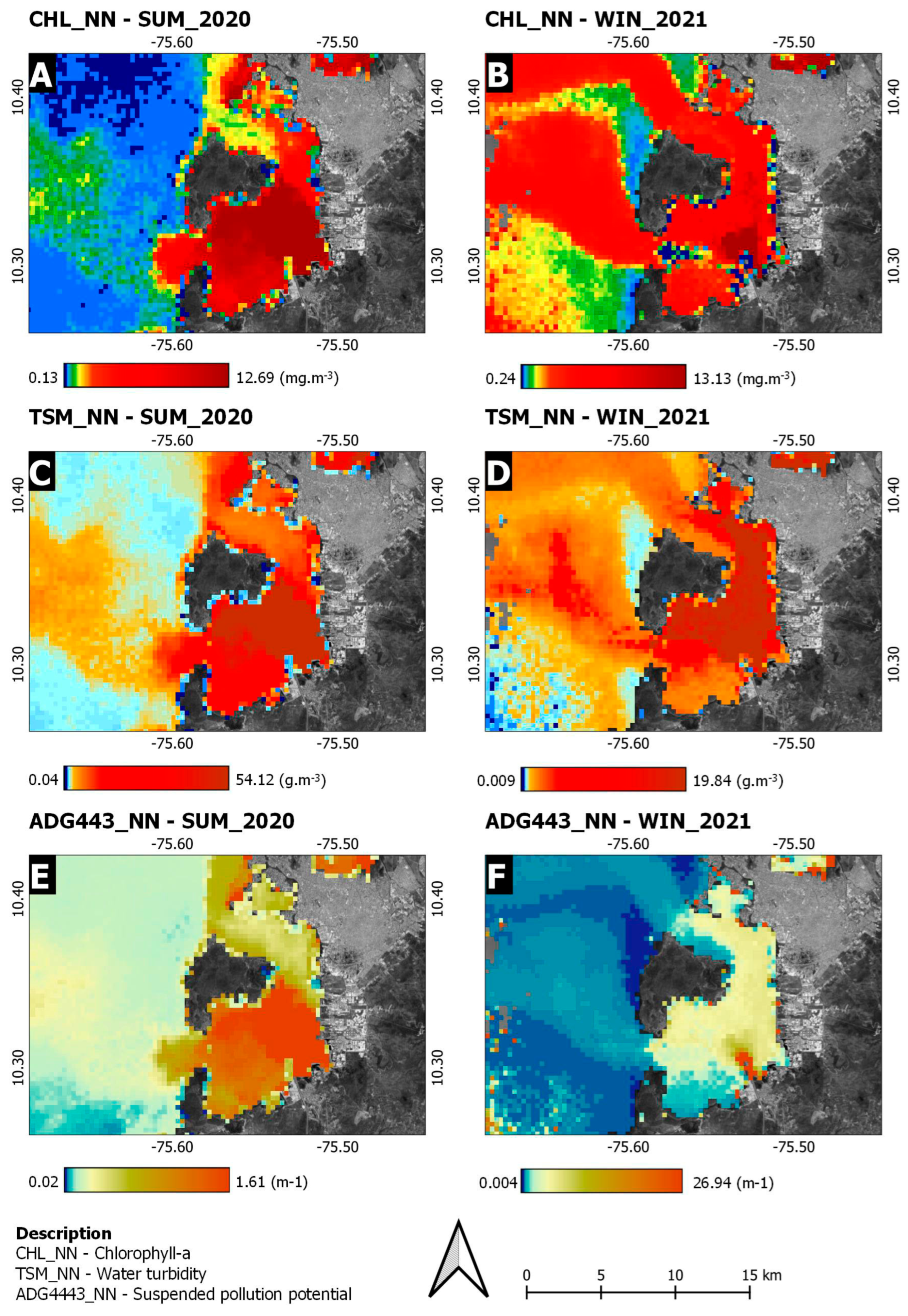
3.2. Analysis of Satellite Images

Images from the Sentinel-3B OLCI satellite are presented in Figure 6. Data were collected from 91 points and analyzed for CHL_NN (m−3), TSM_NN (g m−3), and ADG_443_NN (443 m−1). The results revealed a high intensity of reflectance at the levels of the analyzed wavelengths. A significant difference was observed between CHL_NN and TSM_NN variables, with a lower level of reflectance for chlorophyll (A) and turbidity (B) in the summer of 2020 as compared to the chlorophyll (C) and turbidity (D) indices in the winter of 2021 (Figure 6A–D). However, a higher concentration of chlorophyll is noticeable in the summer of 2020 (A), while in winter (B), it is more dispersed (Figure 6A,B). This change in CHL_NN (m−3) levels can be explained by average precipitation, as the study area recorded an average monthly precipitation of 20.2 mm and a total of 155 mm throughout the winter (Figure 6B) [8,30], which is capable of dispersing CHL_NN levels (m−3) to more extensive areas [1,16].
The analysis of the variable ADG_443_NN (443 m−1) revealed a high reflectance intensity during the winter of 2021 (Figure 6F), indicating potential for suspended pollution, while in the summer of 2020 (Figure 6E), this index was less pronounced. This shows that the particulate matter dissolved in the waters of Cartagena Bay has a high concentration of NPs, which transport quickly dispersible contaminants to other regions through the action of currents, thus potentially compromising the survival of aquatic biodiversity [16,21].
In Figure 6, we can observe the existence of a central flow of the waters of Cartagena Bay with high levels of CHL_NN (m−3), TSM_NN (g m−3), and ADG_443_NN (443 m−1) throughout the analyzed period. This is accomplished due to an estuary, where riverine waters meet those of the ocean [18,21,53]. Estuaries can transport pollutants and contaminants to marine ecosystems, accounting for the high reflectance levels identified in the three variables analyzed [18,21]. Studies by Neckel et al. [1] and Giarratano et al. [21] confirm that there is, in general, an increase in levels of contamination of ocean waters in regions formed by estuaries.
The general statistical data of this study, related to the collection of information using images from the Sentinel-3B OLCI satellite (Table 2), yielded an R2 of 0.693. It is noted that the statistical model remains at a good level of reliability, with a Silhouette index of 0.560, indicating that the clusters are classified by a reasonable level of data homogeneity, which allows for more reliable results based on the particularities of the study area [46,47,54]. When analyzing Table 2, the individual Silhouette indices of clusters 2 and 3 (0.580 and 0.502, respectively) remain acceptable, while cluster 1 (0.280) remains well below the other clusters. In cluster 1, there are only two collection points, while in clusters 2 and 3, there are 69 and 20 collection points, respectively. This indicates that the greater the number of collection points, the more comprehensive the data grouping will be and, consequently, the more efficient it will be to portray the phenomena within the reality of the study [46,47,54].
The Akaike Information Criterion (AIC) demonstrated a total value of 201.860 (Table 2), attributed to the quality of the statistical model used concerning its simplicity [47,54]. Sequentially, the Bayesian Information Criterion (BIC) reached a value of 247.060 (Table 2), becoming an essential tool aimed at selecting statistical models aimed at better fitting data [47,54]. Table 2, based on the sum of squares, shows that clusters 1 (18.786) and 3 (45.106) presented lower values than those obtained in cluster 2 (101.971), demonstrating that the sum of the group reached high quantitative similarity of averages.
It is essential to highlight that the descriptive statistical elements in Table 3 reveal a high variance between summer and winter data for the three variables analyzed. When observing the CHL_NN variable, it is noted that the average varies so that summer (8.197) is higher than winter (5.183). However, the maximum chlorophyll value remains balanced in both seasons (21.806 in summer and 21.030 in winter). This supports the interpretation that in winter, the chlorophyll in the region is more dispersed [16,21]. For the TSM_NN variable, the results follow a similar logic in the average CHL_NN data. The average in summer (33.051) is higher than in winter (14.420).
However, maximum turbidity resulted in 232.553 for winter, while in summer, the recorded value was much lower (100.000). As for the ADG443_NN variable, summer presents its lowest suspended pollution potential values, with an average of 1.195 and a maximum of 4.188. The winter average is 3.909, while the maximum reaches 32.201. Using the ADG443_NN (Table 3), it is possible to evaluate a high difference between the results from summer 2020 (4.188 m−1) and winter 2021 (32.201 m−1). When ADG443_NN is elevated, in this case, in winter, it concentrates more significant water pollution [1]. These results highlight a significant difference in the data collected in summer and winter, explainable by climatic and meteorological variations between the seasons, highlighting the importance of carrying out this type of analysis considering the particularities of each season analyzed [1,55].
The logic behind the K-Means statistical model algorithm to group the 91 collection points from the Sentinel-3B OLCI satellite images can be understood through Table 4, where the data averages within each cluster are observed. In this context, it is noted that cluster 1 presents high levels of CHL_NN (m−3), TSM_NN (g m−3), and ADG_443_NN (443 m−1), in which the majority of chemical elements are concentrated. Aluminum, iron, magnesium, and sodium, among others, were identified in aquatic sediments collected from the field (Table 1).
Figure 7 allows for the visual observation of specialized clustering using the K-Means method. The points are joined according to the distribution of data collected in Cartagena Bay. In this relationship, Table 4 demonstrates that the highest reflectance averages are found in cluster 1, in the Playa Blanca region, where the river meets the ocean. This point source of pollution and contamination flows into the Pacific Ocean and gradually disperses as it moves away from the continent. This led to the characterization of the points within cluster 2 as the furthest from the source of pollution and contamination (Table 4). Cluster 3 demonstrated high values of CHL_NN (1.453 m−3), TSM_NN (1.582 g m−3), and ADG443_NN (1.396 m−1) in the summer season, demonstrating the incidence of more significant water contamination (Table 4).

4. Conclusions

The sediments in the waters of Cartagena Bay, mainly in the Playa Blanca region, showed levels of aluminum, iron, magnesium, and sodium (among others) pollution. These levels of pollutants in sediments, despite being known for decades in other studies at a global level, require additional investigations that can support the development of new public policies aimed at preserving the waters of Cartagena Bay in the future, emphasizing this study’s contribution to the research community and the value added in results collected in the field and by satellite detection.
Data collected by Sentinel-3B OLCI satellite imagery revealed high levels of chlorophyll, turbidity, and the potential for suspended pollution. The reflectance variable CHL443_NN presented its peak suspended pollution potential in the summer of 2021, with an improvement in this index in the winter of 2020. Climatic and meteorological differences between the seasons can explain this disparity. Furthermore, it was observed that in the central region of Cartagena Bay, an estuary receives much of the urban and rural pollution.
The K-Means cluster analysis confirmed previous results, demonstrating the spatialization of the clusters and highlighting their relationship with the estuary. This confirms that pollutants and contaminants are dumped into Cartagena Bay through a point source and dispersed as they move away from the mainland, thus dispersing toxic nanoparticles throughout the ocean ecosystem. The need for new studies on the analysis of the dynamics of nanoparticle movement is evident, using the same methodology as this research to evaluate the influence of human actions on water resources on a global scale.

Author Contributions

Conceptualization, G.M., L.D.M. and G.P.S.; data curation, A.N.; formal analysis, L.S.M. and A.N.; funding acquisition, B.W.B.; investigation, R.T.L.; project administration, M.F.A.T. and A.N.; supervision, M.M.I. and G.M.; visualization, A.N.; writing—original draft preparation, M.M.I. and A.N.; writing—review and editing, M.L.S.O., C.G.R. and A.N. All authors have read and agreed to the published version of the manuscript.

Funding

This research received no external funding.

Institutional Review Board Statement

Not applicable.

Informed Consent Statement

Informed consent was obtained from all subjects involved in the study.

Data Availability Statement

Data are contained within the article.

Acknowledgments

The authors thank the European Space Agency (ESA) and the U.S. National Aeronautics and Space Administration (NASA) for providing the unpublished and treated images from the Sentinel-3B SYN satellite and the NOAA Air Resources Laboratory (ARL) for giving the HYSPLIT transport and dispersion model and/or READY, used in this publication. We also thank the Center for Studies and Research on Urban Mobility (NEPMOUR+S/ATITUS), Brazil; Fundação Meridional, Brazil. We thank FAPESC (Fundação de Amparo à Pesquisa e Inovação do Estado de Santa Catarina); Atlantic International Research Centre (AIR Centre) (https://www.aircentre.org/Scholarship/, accessed on 26 May 2024), Portugal; and the National Council for Scientific and Technological Development (CNPq), Brazil. The authors thank Taif University, Saudi Arabia, for supporting this work through project number (TU-DSPP-2024-03).

Conflicts of Interest

The authors declare no conflicts of interest.

References

  1. Neckel, A.; Oliveira, M.L.; Dotto, G.L.; Maculan, L.S.; Bodah, B.W.; Silva, L. Sentinel-3B OLCI satellite imagery and advanced electron microscopy of nanoparticle analysis in a marine estuary and watershed: Robust multi-analytics and geospatial assessment of key contaminants. J. Hydrol. 2022, 612, 128278. [Google Scholar] [CrossRef]
  2. Fortes, W.M.P.A.; Da Costa Souza, I.; Azevedo, V.; Griboff, J.; Monferrán, M.V.; Wunderlin, D.A.; Matsumoto, S.T.; Fernandes, M.N. Metal/metalloid bioconcentration dynamics in fish and the risk to human health due to water contamination with atmospheric particulate matter from a metallurgical industrial area. Sci. Total Environ. 2023, 902, 166119. [Google Scholar] [CrossRef]
  3. Aguilera, M.A.; González, M.G. Urban infrastructure expansion and artificial light pollution degrade coastal ecosystems, increasing natural-to-urban structural connectivity. Landsc. Urban Plan. 2023, 229, 104609. [Google Scholar] [CrossRef]
  4. Guo, W.; Zhang, D.; Zhang, W.; Shen, L.; Pan, K.; Jiang, H.; Zhang, Q. Anthropogenic impacts on the nitrate pollution in an urban river: Insights from a combination of natural-abundance and paired isotopes. J. Environ. Manag. 2023, 333, 117458. [Google Scholar] [CrossRef] [PubMed]
  5. Souza, I. da. C.; Morozesk, M.; Da Silva Mansano, A.; Mendes, V.A.; Azevedo, V.; Matsumoto, S.T.; Elliott, M.; Monferrán, M.V.; Wunderlin, D.A.; Fernandes, M.N. Atmospheric particulate matter from an industrial area as a source of metal nanoparticle contamination in aquatic ecosystems. Sci. Total Environ. 2021, 753, 141976. [Google Scholar] [CrossRef] [PubMed]
  6. Zhou, H.; Liu, G.; Zhou, C.; Arif, M.; Sun, M.; Chen, Y.; Liu, Y. Water-assisted-mechanical activation of copper pyrometallurgical tailings for molybdenum leaching and selective removal of environmentally-hazardous elements. Sep. Purif. Technol. 2023, 310, 123088. [Google Scholar] [CrossRef]
  7. Ayyamperumal, R.; Balasubramanian, M.; Huang, X.; Zhang, C.; Nazir, N.; Li, F. Spatial distribution and seasonal variation of trace hazardous elements contamination in the coastal environment. Environ. Res. 2024, 243, 117780. [Google Scholar] [CrossRef] [PubMed]
  8. Silva, L.; Lozano, L.P.; Oliveira, M.L.; Da Boit, K.M.; Gonçalves, J.O.; Neckel, A. Identification of hazardous nanoparticles present in the Caribbean Sea for the allocation of future preservation projects. Mar. Pollut. Bull. 2001, 168, 112425. [Google Scholar] [CrossRef] [PubMed]
  9. ESA. European Space Agency. SENTINEL-3 OLCI Introduction. 2024. Available online: https://sentiwiki.copernicus.eu/web/olci-applications (accessed on 26 May 2024).
  10. ESA. European Space Agency. SENTINEL-3 OLCI Resolutions. 2024. Available online: https://www.esa.int/Applications/Observing_the_Earth/Copernicus/Sentinel-3/Facts_and_figures (accessed on 26 May 2024).
  11. ESA. European Space Agency. SENTINEL-3 OLCI Level-2 Water Product Type. 2024. Available online: https://step.esa.int/docs/extra/OLCI_L2_ATBD_Ocean_Colour_Turbid_Water.pdf (accessed on 26 May 2024).
  12. Moro, L.D.; Maculan, L.S.; Pivoto, D.; Cardoso, G.T.; Pinto, D.; Adelodun, B.; Bodah, B.W.; Santosh, M.; Bortoluzzi, M.G.; Branco, E.; et al. Geospatial Analysis with Landsat Series and Sentinel-3B OLCI Satellites to Assess Changes in Land Use and Water Quality over Time in Brazil. Sustainability 2022, 14, 9733. [Google Scholar] [CrossRef]
  13. Staehr, S.U.; Holbach, A.; Markager, S.; Stæhr, P.A. Exploratory study of the Sentinel-3 level 2 product for monitoring chlorophyll-a and assessing ecological status in Danish seas. Sci. Total Environ. 2023, 897, 165310. [Google Scholar] [CrossRef]
  14. Zeng, F.; Song, C.; Cao, Z.; Xue, K.; Lu, S.; Tan, C.; Liu, K. Monitoring inland water via Sentinel satellite constellation: A review and perspective. ISPRS J. Photogramm. Remote Sens. 2023, 204, 340–361. [Google Scholar] [CrossRef]
  15. Li, Y.; Li, S.; Song, K.; Liu, G.; Wen, Z.; Fang, C.; Shang, Y.; Lyu, L.; Zhang, L. Sentinel-3 OLCI observations of Chinese lake turbidity using machine learning algorithms. J. Hydrol. 2023, 622, 129668. [Google Scholar] [CrossRef]
  16. Neckel, A.; Oliveira, M.L.; Maculan, L.S.; Adelodun, B.; Toscan, P.C.; Bodah, B.W.; Moro, L.D.; Silva, L. Terrestrial nanoparticle contaminants and geospatial optics using the Sentinel-3B OLCI satellite in the Tinto River estuary region of the Iberian Peninsula. Mar. Pollut. Bull. 2023, 187, 114525. [Google Scholar] [CrossRef] [PubMed]
  17. Hu, G.; Cao, J. Metal-containing nanoparticles derived from concealed metal deposits: An important source of toxic nanoparticles in aquatic environments. Chemosphere 2019, 224, 726–733. [Google Scholar] [CrossRef] [PubMed]
  18. Cao, S.; Liang, S.; Li, Y. Adsorption and environmental behavior of mercury on suspended particulate matter from the Yellow River and Xiaoqing River estuaries. Sci. Total Environ. 2023, 893, 164860. [Google Scholar] [CrossRef] [PubMed]
  19. Casso-Hartmann, L.; Rojas-Lamos, P.; McCourt, K.; Vélez-Torres, I.; Barba-Ho, L.E.; Bolaños, B.W.; Montes, C.L.; Mosquera, J.; Vanegas, D. Water pollution and environmental policy in artisanal gold mining frontiers: The case of La Toma, Colombia. Sci. Total Environ. 2022, 852, 158417. [Google Scholar] [CrossRef]
  20. Gari, S.R.; Guerrero, C.E.O.; A-Uribe, B.; Icely, J.; Newton, A. A DPSIR-analysis of water uses and related water quality issues in the Colombian Alto and Medio Dagua Community Council. Water Sci. 2018, 32, 318–337. [Google Scholar] [CrossRef]
  21. Giarratano, E.; Di Mauro, R.; Silva, L.; Tomba, J.P.; Hernández-Moresino, R.D. The Chubut River estuary as a source of microplastics and other anthropogenic particles into the Southwestern Atlantic Ocean. Mar. Pollut. Bull. 2022, 185, 114267. [Google Scholar] [CrossRef] [PubMed]
  22. Garcés-Ordóñez, O.; Díaz, L.F.E.; Cardoso, R.P.; Muniz, M.C. The impact of tourism on marine litter pollution on Santa Marta beaches, Colombian Caribbean. Mar. Pollut. Bull. 2020, 160, 111558. [Google Scholar] [CrossRef]
  23. Rangel-Buitrago, N.; Gracia, A. From the closet to the shore: Fashion waste pollution on Colombian Central Caribbean beaches. Mar. Pollut. Bull. 2024, 199, 115976. [Google Scholar] [CrossRef]
  24. Díaz-Mendoza, C.; Ordiales, P.A.; Bustos, M.L.; Cervantes, O.; Palacios-Moreno, M.; San-Martin, T.V.; Lopes, G.K.; Vallejo, M.I.; Mouthon-Bello, J.; Gutiérrez, L. Abundance and distribution of cigarette butts on the sand of five touristic beaches in Latin America during the COVID-19 pandemic. Mar. Pollut. Bull. 2023, 194, 115306. [Google Scholar] [CrossRef]
  25. Wang, Y.; Yuan, Q.; Zhou, S.; Zhang, L. Global spatiotemporal completion of daily high-resolution TCCO from TROPOMI over land using a swath-based local ensemble learning method. ISPRS J. Photogramm. Remote Sens. 2022, 194, 167–180. [Google Scholar] [CrossRef]
  26. Pommier, M. Estimations of NOx emissions, NO2 lifetime and their temporal variation over three British urbanised regions in 2019 using TROPOMI NO2 observations. Environ. Sci. 2023, 3, 408–421. [Google Scholar] [CrossRef]
  27. Rodríguez-Benito, C.V.; Navarro, G.; Caballero, I. Using Copernicus Sentinel-2 and Sentinel-3 data to monitor harmful algal blooms in Southern Chile during the COVID-19 lockdown. Mar. Pollut. Bull. 2020, 161, 111722. [Google Scholar] [CrossRef] [PubMed]
  28. Polikarpov, I.; Al-Yamani, F.; Petrov, P.; Saburova, M.; Mihalkov, V.; Al-Enezi, A. Phytoplankton bloom detection during the COVID-19 lockdown with remote sensing data: Using Copernicus Sentinel-3 for north-western Arabian/Persian Gulf case study. Mar. Pollut. Bull. 2021, 171, 112734. [Google Scholar] [CrossRef] [PubMed]
  29. Rangel-Buitrago, N.; Williams, A.T.; Micallef, A.; Neal, W.J.; Pilkey, O.H. Not all that glitters is gold: Can the real scenic value of the Colombian Caribbean coast be restored? Ocean Coast. Manag. 2022, 227, 106292. [Google Scholar] [CrossRef]
  30. DANE. National Administrative Department of Statistics. Results National Census of Población of Vivienda, Santa Marta, Magdalena. 2021. Available online: https://www.dane.gov.co/files/investigaciones/planes-departamentos-ciudades/211022-InfoDane-Cartagena-Bolivar.pdf (accessed on 29 August 2023).
  31. Tosic, M.; Martins, F.; Lonin, S.A.; Izquierdo, A.; Restrepo, J.D. Hydrodynamic modelling of a polluted tropical bay: Assessment of anthropogenic impacts on freshwater runoff and estuarine water renewal. J. Environ. Manag. 2019, 236, 695–714. [Google Scholar] [CrossRef] [PubMed]
  32. Acosta-Coley, I.; Méndez-Cuadro, D.; Rodríguez-Cavallo, E.; De La Rosa, J.; Olívero-Verbel, J. Trace elements in microplastics in Cartagena: A hotspot for plastic pollution at the Caribbean. Mar. Pollut. Bull. 2019, 139, 402–411. [Google Scholar] [CrossRef]
  33. Espinosa-Díaz, L.F.; Sánchez-Cabeza, J.; Sericano, J.L.; Parra, J.P.; Ibarra-Gutiérrez, K.P.; Garay-Tinoco, J.A.; Portela, J.I.C.; Alonso-Hernández, C.; Ruíz-Fernández, A.C.; Quejido-Cabezas, A.J.; et al. Sedimentary record of the impact of management actions on pollution of Cartagena bay, Colombia. Mar. Pollut. Bull. 2021, 172, 112807. [Google Scholar] [CrossRef]
  34. Montero, A.A.G.; Costa-Redondo, L.C.; Vasco-Echeverri, Ó.; Rengifo, V.A.A. Microplastic pollution in coastal areas of Colombia: Review. Mar. Environ. Res. 2023, 190, 106027. [Google Scholar] [CrossRef]
  35. Acuña, C.; Betancur, J.D.; De Jesús Arrieta Baldovino, J.; Barboza, G.; Saba, M. Analysis of Dispersivity in Marine Clays of Cartagena de Indias, Colombia. Geosciences 2023, 13, 162. [Google Scholar] [CrossRef]
  36. Neckel, A.; Osorio-Martinez, J.; Pinto, D.; Bodah, B.W.; Adelodun, B.; Silva, L. Hazardous elements present in coal nanoparticles in a Caribbean port region in Colombia. Sci. Total Environ. 2022, 838, 156363. [Google Scholar] [CrossRef] [PubMed]
  37. Neckel, A.; Oliveira, M.L.; Bolaño, L.J.C.; Maculan, L.S.; Moro, L.D.; Bodah, E.T.; Moreno-Ríos, A.L.; Bodah, B.W.; Silva, L. Biophysical matter in a marine estuary identified by the Sentinel-3B OLCI satellite and the presence of terrestrial iron (Fe) nanoparticles. Mar. Pollut. Bull. 2021, 173, 112925. [Google Scholar] [CrossRef] [PubMed]
  38. Caballero-Gallardo, K.; Alcala-Orozco, M.; Barraza-Quiroz, D.; De La Rosa, J.; Olívero-Verbel, J. Environmental risks associated with trace elements in sediments from Cartagena Bay, an industrialized site at the Caribbean. Chemosphere 2020, 242, 125173. [Google Scholar] [CrossRef] [PubMed]
  39. Graca, B.; Zgrundo, A.; Zakrzewska, D.; Rzodkiewicz, M.; Karczewski, J. Origin and fate of nanoparticles in marine water—Preliminary results. Chemosphere 2018, 206, 359–368. [Google Scholar] [CrossRef]
  40. Vanhellemont, Q.; Ruddick, K. Atmospheric correction of Sentinel-3/OLCI data for mapping of suspended particulate matter and chlorophyll-a concentration in Belgian turbid coastal waters. Remote Sens. Environ. 2021, 256, 112284. [Google Scholar] [CrossRef]
  41. Abdallah, K.W.; Samar, F.; Djabourabi, A.; Harid, R.; Izeboudjen, H.; Bachari, N.E.I.; Houma-Bachari, F. A preliminary assessment of Sentinel-3 ocean and land color instrument data for the estimation of chlorophyll-a concentration using bio-optical methods in Annaba Bay and El Kala’s coast (Algerian Basin). Reg. Stud. Mar. Sci. 2023, 61, 102882. [Google Scholar] [CrossRef]
  42. Huang, Y. Triangular irregular network generation and topographical modeling. Comput. Ind. 1989, 12, 203–213. [Google Scholar] [CrossRef]
  43. Arnone, E.; Francipane, A.; Dialynas, Y.G.; Noto, L.; Bras, R.L. Implications of terrain resolution on modeling rainfall-triggered landslides using a TIN- based model. Environ. Model. Softw. 2021, 141, 105067. [Google Scholar] [CrossRef]
  44. Moro, L.D.; Maculan, L.S.; Neckel, A.; De Vargas Mores, G.; Pivoto, D.; Bodah, E.T.; Bodah, B.W.; Oliveira, M.L. Geotechnologies applied to the analysis of buildings involved in the production of poultry and swine to the integrated food safety system and environment. J. Environ. Chem. Eng. 2021, 9, 106475. [Google Scholar] [CrossRef]
  45. Kim, H.; Kim, H.; Cho, S. Improving spherical k-means for document clustering: Fast initialization, sparse centroid projection, and efficient cluster labeling. Expert Syst. Appl. 2020, 150, 113288. [Google Scholar] [CrossRef]
  46. Li, X.; Yao, R.; Liu, M.; Costanzo, V.; Yu, W.; Wang, W.; Short, C.A.; Li, B. Developing urban residential reference buildings using clustering analysis of satellite images. Energy Build. 2018, 169, 417–429. [Google Scholar] [CrossRef]
  47. Naghizadeh, A.; Metaxas, D.N. Condensed Silhouette: An optimized filtering process for cluster selection in K-Means. Procedia Comput. Sci. 2020, 176, 205–214. [Google Scholar] [CrossRef]
  48. Tardioli, G.; Kerrigan, R.; Oates, M.; O’Donnell, J.; Finn, D. Identification of representative buildings and building groups in urban datasets using a novel pre-processing, classification, clustering and predictive modelling approach. Build. Environ. 2018, 140, 90–106. [Google Scholar] [CrossRef]
  49. Mohanavelu, A.; Shrivastava, S.; Naganna, S.R. Streambed pollution: A comprehensive review of its sources, eco-hydro-geo-chemical impacts, assessment, and mitigation strategies. Chemosphere 2022, 300, 134589. [Google Scholar] [CrossRef] [PubMed]
  50. Kohrs, D.; Volkmann, J.; Wegner, H.A. Influence of substitution on the supramolecular chemistry of Cycloparaphenylene-Fullerene complexes. Eur. J. Org. Chem. 2023, 26, e202300575. [Google Scholar] [CrossRef]
  51. Silva, L.; Dotto, G.L.; Pinto, D.; Oliveira, M.L. Nanoparticles and interfaces with toxic elements in fluvial suspended sediment. Mar. Pollut. Bull. 2021, 168, 112405. [Google Scholar] [CrossRef]
  52. Oliveira, M.L.; Dotto, G.L.; Pinto, D.; Neckel, A.; Silva, L. Nanoparticles as vectors of other contaminants in estuarine suspended sediments: Natural and real conditions. Mar. Pollut. Bull. 2021, 168, 112429. [Google Scholar] [CrossRef]
  53. Suo, A.; Li, H.; Zhou, W.; Jiao, M.; Zhang, L.; Yue, W. Estimation of ecological carrying capacity of small-scale fish in marine ranch of the Pearl River Estuary, China. Reg. Stud. Mar. Sci. 2023, 61, 102901. [Google Scholar] [CrossRef]
  54. Zhu, S.; Xu, L. Many-objective fuzzy centroids clustering algorithm for categorical data. Expert Syst. Appl. 2018, 96, 230–248. [Google Scholar] [CrossRef]
  55. Giannini, F.; Hunt, B.P.V.; Jacoby, D.; Costa, M. Performance of OLCI Sentinel-3A satellite in the Northeast Pacific coastal waters. Remote Sens. Environ. 2021, 256, 112317. [Google Scholar] [CrossRef]
Figure 1. Location of study area in Cartagena Bay, with satellite photo and physical sediment collection points in Cartagena, Colombia.
Sustainability 16 04639 g001
Figure 2. Methodological procedures and equipment used for the laboratory analysis in the following steps: Step 1—The separation of the sampled sediment in an aqueous medium; Step 2—Conditioning the samples for 48 h; Step 3—The ultrafiltration of samples (Whatman Anodisc membrane, with 20 nm pores); Step 4—Using FE-SEM and HR-TEM.
Sustainability 16 04639 g002
Figure 3. The XRD results demonstrate quartz and kaolinite as the most abundant elements.
Sustainability 16 04639 g003
Figure 4. Scanning electronic microstructure of pollution samples collected in the regions of the Bocagrande neighborhood and Isla Tierra Bomba in Cartagena Bay.
Sustainability 16 04639 g004
Figure 5. Major clusters identified by EDS in the Playa Blanca region contain a high potential of amorphous material with the presence of massive gypsum, rozenit, and melanterite crystals.
Sustainability 16 04639 g005
Figure 6. Composition of Sentinel-3B OLCI satellite images: CHL_NN summer 2020 (A); CHL_NN winter 2021 (B); TSM_NN summer 2020 (C); TSM_NN winter 2021 (D); ADG443_NN summer 2020 (E); ADG443_NN winter 2021 (F).
Sustainability 16 04639 g006
Figure 7. A map of clusters defined based on the demarcation of collection points using images from the Sentinel-3B OLCI satellite.
Sustainability 16 04639 g007
Table 1. Deposition of nanominerals identified in samples collected (x = presence of substance) from the Bocagrande neighborhood, Isla Tierra Bomba, and Playa Blanca in Cartagena Bay.
Identified MineralBocagrande NeighborhoodIsla Tierra BombaPlaya Blanca
Anatasexxx
Anhydrite--x
Bararitexxx
Baritexxx
Calcitexxx
Chromite-xx
Chloritexxx
Goethitexxx
Halitexxx
Hematitexxx
Illitexxx
Kaolinitexxx
Metakaolinitexxx
Monazitex-x
Quartzxxx
Rutilexxx
Siderite-x-
Gypsumxxx
Pyrite-xx
Fullerenexxx
Amorphous xxx
Table 2. Representation of K-Means Clustering and Cluster Information.
K-Means Clustering
ClustersNR2AICBICSilhouette
3910.693201.860247.0600.560
Cluster Information
Cluster123
Size26920
Explained proportion within-cluster heterogeneity0.1130.6150.272
Within the sum of squares18.786101.97145.106
Silhouette score0.2800.5800.502
Table 3. Descriptive statistics of data collected from Sentinel-3B OLCI satellite images.
ItemsCHL_NNTSM_NNADG443_NN
Summer 2020Winter 2021Summer
2020
Winter 2021Summer
2020
Winter 2021
Valid919191919191
Missing000000
Mean8.1975.18333.05114.4201.1953.909
Std. Deviation6.7103.76935.00029.3200.9185.111
Minimum0.1820.0640.9640.1570.1110.074
Maximum21.80621.030100.000232.5534.18832.201
Table 4. Cluster Means results from applied statistics.
ItemsCHL_NNTSM_NNADG443_NN
Summer 2020Winter 2021Summer
2020
Winter 2021Summer
2020
Winter 2021
Cluster 11.3601.3331.9136.1982.6425.396
Cluster 2−0.460−0.287−0.514−0.231−0.481−0.242
Cluster 31.4530.8571.5820.1761.3960.295
Disclaimer/Publisher’s Note: The statements, opinions and data contained in all publications are solely those of the individual author(s) and contributor(s) and not of MDPI and/or the editor(s). MDPI and/or the editor(s) disclaim responsibility for any injury to people or property resulting from any ideas, methods, instructions or products referred to in the content.

