Article

Exploring the Effects of Urban Development in Ten Chinese Node Cities along the Belt and Road Initiative on Vegetation Net Primary Productivity

1
College of Forestry, Nanjing Forestry University, Longpan Road 159, Nanjing 210037, China
2
Co-Innovation Center for Sustainable Forestry in Southern China, Nanjing Forestry University, Nanjing 210037, China
*
Author to whom correspondence should be addressed.
Sustainability 2024, 16(11), 4845; https://doi.org/10.3390/su16114845
Submission received: 7 April 2024 / Revised: 20 May 2024 / Accepted: 31 May 2024 / Published: 6 June 2024
(This article belongs to the Special Issue Urban Planning and Sustainable Land Use—2nd Edition)

Abstract

:
Urbanization and economic growth in node cities surged due to the Belt and Road Initiative (BRI), leading to significant environmental changes, notably in vegetation net primary productivity (NPP). Investigating the ecological impact of these urban changes was crucial, despite scarce relevant studies. We employed Sen’s slope estimation and Mann–Kendall trend analysis to study NPP trends (2005–2020) in ten Belt and Road node cities. The Optimized Parameters Geographic Detector Model (OPGD) analyzed factors impacting NPP and their interactions. Results revealed significant NPP variations among the ten cities, ranging from 656.47 gCm−2a−1 to 250.55 gCm−2a−1, with over 79% showing increasing trends. Since 2013, Chongqing, Wuhan, Hefei, Nanchang, and Changsha experienced declining NPP, while the other five cities saw an increase. Natural factors like temperature, precipitation, and DEM predominantly influence rising NPP trends, while anthropogenic factors like land use changes and nighttime light drive NPP decline. Land use changes, with 39.0% explanatory power, primarily affect NPP. After 2013, construction land increased by 117.7 km2 on average, while arable land decreased by 274.8 km2, contributing to decreased vegetation cover NPP. Nighttime lights explained up to 25% of NPP variance. Regions with high nocturnal light values exhibited more developed urbanization but comparatively lower NPP levels.

1. Introduction

Proposed in 2013 in China, the globally acknowledged “Belt and Road” Initiative (BRI), commonly referred to as the Silk Road Economic Belt and the 21st Century Maritime Silk Road (https://www.yidaiyilu.gov.cn, accessed on 18 October 2023) aims to forge stronger economic connections with neighboring countries, promoting trade and investment, strengthening infrastructure construction, and fostering global economic development [1,2]. For China, the Belt and Road Initiative’s execution successfully reduced regional economic disparities, particularly by promoting exchanges between eastern and western cities [3]. This approach leveraged the higher economic development level of eastern cities to propel the development of relatively lower-income cities in the middle and western parts, aiming for coordinated progress. Consequently, eastern cities expanded their openness and optimized their industrial structure, while central cities, serving as pivotal hubs connecting the east and west, played a crucial role. Western cities, as key nodes in the Silk Road Economic Belt, enhanced urban infrastructure and reformed and strengthened financial systems, thereby narrowing the economic gap with the eastern regions [4,5].
Since the 20th century, urbanization has emerged as the most important aspect of human growth [6,7]. The rapid expansion of cities has profoundly impacted vegetation, primarily seen in the fragmentation of landscape patterns and structural changes in land use [8]. Due to economic growth and rural-to-urban migration, as well as the building of transportation infrastructure like roads and trains [9], extensive areas of vegetation cover have been converted into impermeable surfaces [10]. The natural climatic and air conditions were greatly impacted by this, which resulted in the heat island phenomenon [11]. Urban areas experienced higher temperatures than suburban and rural areas, impacting the environment and vegetation growth phenology. Phenological changes further influenced numerous ecological processes, including net primary productivity (NPP) [12]. The world witnessed an unparalleled surge in urbanization. This urbanization has accelerated the changes to terrestrial eco-systems during the past few decades [13]. Consequently, it made sense to look into the consequences of urbanization on the natural environment more [14].
Inland node cities along the Belt and Road include ten major cities in western and central China, including Hefei, Nanchang, Zhengzhou, Wuhan, Changsha, Xi’an, Chongqing, Lanzhou, Xining, and Chengdu [15]. As crucial promoters and implementers of the initiative, these cities have experienced population growth, gradual expansion of urban areas, per capita GDP increase, and a noticeable acceleration in the urbanization process, all driven by the promotion of economic development [16,17,18,19]. Urban expansion inevitably involved a shift in urban land use types, with increased construction and expansion of infrastructure, including the addition and enlargement of roads, railways, and ports, as well as increased investment in industrial and energy-related sectors [20,21]. These changes unavoidably altered the utilization of natural resources in urban areas, thereby influencing the urban ecological environment.
Net primary productivity (NPP) of vegetation is widely regarded as an essential indicator for evaluating the ecological environment of a given location [22], which could also characterize urban ecological health [23,24]. It serves as a reflection of the productive capacity within a vegetation ecosystem, playing an essential role in maintaining carbon cycling and balance [25,26,27]. Terrain elements, including slope, aspect and elevation play a regulatory role in the physical and chemical characteristics of plant growth environment, thereby impacting NPP [28,29]. The demographic expansion accompanying urban economic development, along with urban expansion and shifts in land use, emerged as pivotal factors affecting NPP dynamics within urban environments [30,31,32,33]. Previous studies only focused on individual natural factors. Wei et al., for instance, only looked at how the environment affected NPP in Shanxi Province [27], whereas Wu et al. only looked at how human activity affected net primary output in Guangdong Province [34]. There is a lack of comprehensive studies in these documents on the combined impact of these factors. However, throughout the urban development process, changes in NPP may have resulted from the combined effects of various factors [35]. The variation in NPP across different cities is likely governed by different dominant factors, leading to diverse trends. Therefore, our study aimed to investigate the influence and interaction of several factors affecting the dynamic changes in urban NPP to fill these gaps. In addition to preventing urban economic development from compromising environmental sustainability, this was crucial for a thorough investigation, but also provided a deeper understanding of how interactions among different factors affected ten different cities.
The optimal parameters-based geographic detector (OPGD) model incorporates a parameter optimization module, enabling various ways of discretizing independent variables based on their features. As a result, the optimal discretization scheme could be selected, leading to improved accuracy in spatial analysis [36]. This approach differed from traditional geodetector models, as traditional models primarily focus on data discretization, often determining the number of discretization bins based on empirical knowledge, lacking quantitative evaluation. OPGD is an innovative analytical method that overcomes the limitations of traditional models. It utilizes a parameter optimization process involving spatial discretization and spatial scale to reveal additional geographic features and information [37]. This provides robust support for analyzing the driving factors of NPP.
As a part of this study, ten Chinese cities with distinct natural conditions and significant disparities in urban development were examined. Also, the Belt and Road policy promotes economic development in different ways among these cities, according to its implementation. As a result, we examined the spatiotemporal characteristics of NPP in these cities prior to and following Belt and Road implementation. The aims of our research were twofold: (1) analyzing the spatiotemporal trends of NPP in these ten node cities over the past two decades, before and after the Belt and Road policy; and (2) examining the primary factors influencing the spatiotemporal variability of NPP in different cities, with particular emphasis on the interplay between natural elements and human activities and their effects on NPP dynamics.

2. Materials and Methods
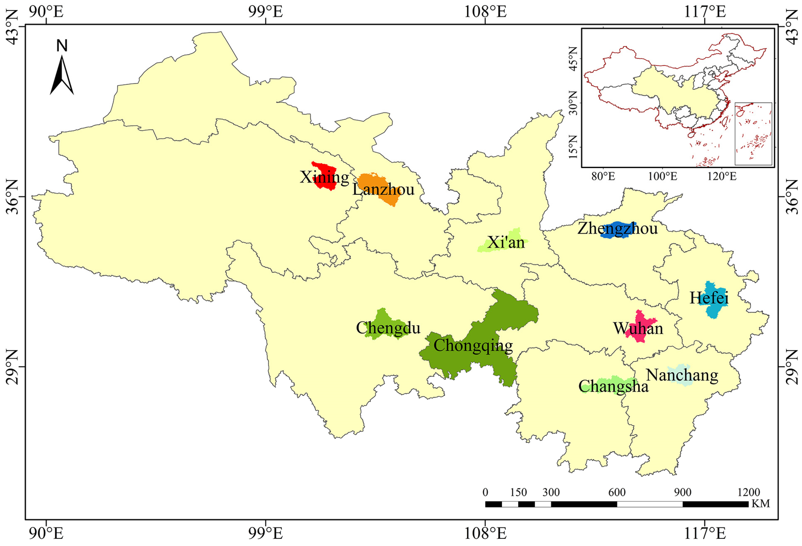
2.1. Research Space

The document “Vision and Actions on Jointly Building Silk Road Economic Belt and 21st-Century Maritime Silk Road” proposed in 2015 highlights the establishment of a novel inland region for reform and economic liberalization in Xi’an, expediting the progress and expansion of Lanzhou and Xining. The objective was to establish Chongqing as a significant hub for the advancement of western development and opening-up. Additionally, it was intended to create inland open economic highlands in cities such as Chengdu, Wuhan, Zhengzhou, Nanchang, Hefei, Changsha and others (source: https://www.yidaiyilu.gov.cn, accessed on 18 October 2023). Therefore, we selected ten cities (Figure 1) that were emphasized as key areas for our research as follows: Xining, Lanzhou, Xi’an, Chongqing, Zhengzhou, Chengdu, Changsha, Wuhan, Nanchang and Hefei. Chongqing, referred to as the Mountain City, is the sole municipality under the direct control of the central government among the ten cities. The topography of Chongqing is characterized by higher elevation in the east and lower elevation in the west, with notable variations in height. It is characterized by a subtropical monsoon humid climate. The dominating vegetation type consists mostly of subtropical evergreen broad-leaved forest, with secondary distribution of mixed forests containing both evergreen broad-leaved and deciduous broad-leaved species. By the conclusion of 2022, the forest covering rate in Chongqing had reached an impressive 55.04%, and its ecological environment quality ranks first among the ten cities. If ranked by GDP level, Chongqing has the highest GDP level among the top ten cities, reaching 2912.90 billion CNY in 2022. Meanwhile, cities with a GDP exceeding one trillion CNY include Chengdu, Wuhan, Changsha, Zhengzhou, Hefei, and Xi’an.
Cities located in the southern region of the ten cities have greater GDP levels compared to cities in the area to the north. Among them, Xining and Lanzhou have the lowest economic development levels. The ecological environment quality is poor in Lanzhou, Xining, and Zhengzhou, with the dominant vegetation type being grassland, with a total area of 13,100 square kilometers, 7660 square kilometers and 7567 square kilometers, respectively. Hefei, Wuhan, and Nanchang are located in the southeastern region. Their total areas are 11,445 square kilometers, 8569.15 square kilometers, and 7195 square kilometers, respectively. The predominant vegetation in this region consists of a diverse combination of evergreen and deciduous trees found within the broad-leaved forest vegetation zone. The ecological environment quality is at the average level among the ten cities. Changsha, Chengdu, and Chongqing have the best ecological environment quality among the ten cities. They are located in the southwest direction, with total areas of 11,819 square kilometers, 14,335 square kilometers, and 82,402 square kilometers, respectively. Their primary vegetation type consists of subtropical evergreen broad-leaved forests, which are characterized by a combination of evergreen and deciduous broad-leaved trees. Xi’an, with an approximate total area of 10,752 square kilometers, serves as the origin of the Silk Road. It is situated in the mild temperate zone and experiences a climate defined by a semi-humid continental monsoon climate. The flora is primarily composed of arboreal and shrubby plants.

2.2. Data Acquisition

The BRI was proposed in 2013, so we selected data from the period of 2005–2020, which allows us to observe the changes before and after the policy implementation more conveniently. Please refer to Table 1 for the data utilized in this study.
The data for NPP in this study was obtained by downloading from the publicly available data pool on LP DACC (https://lpdaac.usgs.gov, accessed on 24 July 2023). We selected the MOD17A3HGF 6.1 product for the years 2005 to 2020. This product has high resolution and long-term time series, which are crucial for analyzing the long-term trends in vegetation productivity in urban environments. Moreover, it utilizes validated and reliable algorithms and models, ensuring the data’s high accuracy and credibility.
The China Meteorological Data Website (https://data.cma.cn, accessed on 18 July 2023) was used to obtain meteorological data. Monthly precipitation and monthly average temperature data for each city were specifically chosen from the years 2005 to 2020, and the data were interpolated using ANUSPLIN 4.4 software to generate a raster dataset of annual precipitation and annual mean temperature data. This dataset was then processed to ensure that the projections aligned with the NPP data. The raster projections were in agreement with the NPP data.
The DEM data were acquired from the Geographic Spatial Data Cloud (https://www.gscloud.cn, accessed on 8 August 2023), specifically the ASTER GDEM dataset with a spatial resolution of 30 m × 30 m, which provided digital elevation data. The study utilized slope and aspect data taken from the DEM dataset.
Land use data for the period from 2005–2020 were acquired by downloading from LPDACC’s public data pools (https://lpdaac.usgs.gov, accessed on 26 July 2023), and the selected data product is MCD12Q1 version 6.1. This study utilized the IGBP classification method according to research needs and referring to the CLCD national land cover data from 1985–2021, which was published by Prof. Yang Jie and the research team led by Huang Xin at Wuhan University [38] to reclassify land cover types.
Population density data for the period 2005 to 2020 is sourced from WorldPop, with a spatial resolution of 1 km × 1 km (https://hub.worldpop.org/geodata/summary?id=39773, accessed on 4 August 2023). The WorldPop project offers high-quality population data from around the world, aiding in addressing global issues like population growth and urbanization.
The GDP data were obtained from Chen et al. [39], and the dataset has the benefits of extensive coverage and a lengthy duration. This dataset offers the benefits of extensive coverage and a lengthy duration. Furthermore, this study utilizes grid-based GDP data growth that has been adjusted using nighttime light data, enhancing its objectivity and comparability, therefore making it more suitable for this research.
Nighttime light data were obtained from the China Long-Term Sequential Yearly Artificial Nighttime Light Dataset, published by Zhang et al. [40] at the National Tibetan Plateau Data Center. Compared to other NTL datasets, PANDA-China exhibits a longer dynamic temporal range and higher temporal consistency and demonstrates stronger correlations with key socio-economic indicators representing different stages of development, such as built-up areas, GDP, and population.

2.3. Methods

2.3.1. Theil-Sen Median Trend Analysis

Calculating trend statistics with Theil–Sen Median trend analysis [41] is a reliable and non-parametric technique used to calculate trend statistics. One can obtain trends in the time series of sample data and their quantified values. Theil–Sen is able to provide a more accurate straight-line fit to non-normally distributed sample data than the simple linear fit. The least squares effect can also be achieved for normally distributed sample data, thus reducing the impact of data outliers on the calculation results of all samples; please refer to Formula (1) for more details.
s l o p e = M e d i a n X m X k m k ,       1 k < m n
In the above formula, the variable n represents duration of time series, with a value of 20. The variables k and m denote time, while X represents the sample value. A positive slope indicates an ascending pattern in the time series, while a negative slope indicates a descending pattern.

2.3.2. Mann–Kendall Method

A statistical test that is not based on parameters is the Mann–Kendall significance test [42]. There is no requirement for the sample data to adhere to a specific distribution scenario. It has robust resilience to data mistakes in samples and is effective to some extent against noise bias. Statistics provide some theoretical support for significance tests. Thus, it has a high degree of applicability. The Mann–Kendall significance test uses the following equations:
S = k = 1 n 1 m = k + 1 n s g n ( X m X k ) ,   1 k < m n
In the formula, time series length is n, n = 20; k and m represent time; X is the sample value; s g n X m X k is a symbolic function as follows:
s g n X m X k =   1 ,     X m X k > 0   0 ,         X m X k = 0 1 ,       X m X k < 0  
The standard test statistics T can be calculated using formula as follows:
T = D 1 V A R ( D ) ,   D > 0 0   ,           D = 0 D + 1 V A R ( D ) ,   D < 0
In the formula, V A R D is the variance; T is a normally distributed statistic; An growing trend is shown when T > 0, and a declining trend is observed when T < 0.
The integration of Theil-Sen trend evaluation with the Mann–Kendall analysis improves the method’s capacity to mitigate the effects of noise, improving the scientific validity and accuracy of the test results. Refer to Table 2 for the specific trend grading table.

2.3.3. Variation Stability Analysis

There may be potential biases in the original data, and stability analysis can characterize the magnitude and fluctuation characteristics of elements during the research phase [43]. One type of statistical metric is known as the coefficient of variation that quantifies the relative variability of a variable, providing insight into the stability of a data series. Use the coefficient of variation to objectively assess NPP variations in ten nodal cities from 2005 to 2020. A higher coefficient of variation indicates greater instability in NPP changes. Please refer to Formula (5) for detailed information.
C v = 1 x i = 1 p ( x i x ¯ ) 2 p 1
In the formula, Cv indicates the variation coefficient; p represents the number of years, which is 16 in this research; x i shows the i-th year’s NPP; x ¯ represents the mean NPP. Stability can be categorised into four categories based on the coefficient of variation (Cv): (1) highly stable, where Cv is less than 0.1; (2) stable, where Cv is between 0.1 and 0.2; (3) unstable, where Cv is between 0.2 and 0.3; and (4) highly unstable, where Cv is greater than 0.3.

2.3.4. Geographical Detector

Geographical detectors (Geodetectors) are a collection of statistical techniques used to identify and understand the causes of geospatial variations [44]. They are effective in analyzing the link between dependent and independent variables. This study primarily employed two modules, namely the “factor detector” and the “interaction detector”, to discover regional variations in plant NPP and examine factor influences and interactions, quantified using the q-value.
q = 1 1 N σ 2 h = 1 T N h σ h 2 = 1 S S W S S T
The q-value in the calculation quantifies the degree to which the driving forces explain the variation in NPP. The range is bounded between 0 and 1; a higher value of q indicates that factor X has more explanatory power for attribute Y. In this study, we implemented the geodetector based on optimal parameters (OPGD) using the “GD” package developed by Song et al. [37].

2.3.5. Land Use Transfer Matrix

Over the course of the research, the land use transition matrix was able to precisely estimate the influx and displacement of various types of land. Specifics are in Equation (7).
M i j = M 11 M 12 M 21 M 12     · · · M 1 j · · · M 2 j M i 1 M i 2     · · · M i j
In the equation, i, j are land use types; M i j is repersents the likehood of land use type i being transformed into land use j, and M i j must satisfy both 0 M i j 1, M i j = 1.

3. Results

3.1. The Inter-Annual Variations of Vegetation NPP in Each Node City

Between 2005 and 2020, the NPP of the 10 cities located along the Belt and Road exhibited a consistent rising trajectory, as illustrated in Figure 2, with an annual average NPP value reaching 477.97 gCm−2a−1. The average NPP values of Chongqing, Chengdu, and Changsha, as well as Xi’an, are above the overall average NPP of the ten cities. When considering the ten cities as a whole, those located in the eastern region, such as Wuhan, Nanchang, and Hefei, have annual average NPP values similar to the overall NPP mean. Meanwhile, in the northwest, Lanzhou and Xining, as well as the northeast city of Zhengzhou, have NPP values lower than the overall average.
Chongqing is the only directly administered municipality among the ten cities. Since its establishment as a direct-administered municipality in 1997, Chongqing’s economic development has attracted global attention, and it plays a crucial role in the BRI. Situated in the southwestern region of China, Chongqing’s vegetation is predominantly subtropical evergreen broadleaf forest, with secondary distribution of mixed forests of evergreen and deciduous broadleaf trees. Among the ten cities, Chongqing has the largest land area, the highest economic status, and the highest annual average NPP. Over the years, the range of average vegetation NPP has been between 567.32 and 684.92 gCm−2a−1; the minimum value was observed in 2006, while the maximum value was recorded in 2015. Examining the period with 2013 as the time node, Chongqing’s NPP growth rate is 9.17% (Table 3).
To the west of Chongqing is Chengdu, the city with the second-highest average NPP among the ten cities, reaching 627.43 gCm−2a−1. To the east of Chongqing are Wuhan, Hefei, Nanchang, and Changsha. Among them, Changsha has the third-highest average NPP among the cities, with an NPP value of 598.83 gCm−2a−1. Wuhan, Hefei, and Nanchang, regardless of whether considering average NPP or NPP growth rate, exhibit close similarities, and the NPP trends in these three cities are relatively stable. To the north of Chongqing is Xi’an, ranking fourth in terms of average NPP among the ten cities, specifically at 540.66 gCm−2a−1. Xi’an exhibits the most significant fluctuations in NPP among the ten cities, showing high instability. In the northwest and northeast of Chongqing are Xining, Lanzhou, and Zhengzhou. The NPP values of these three cities are lower than the overall NPP average, ranking in the last three positions among the ten cities.
After the proposal of the BRI in 2013, NPP values of vegetation in five cities in the western region exhibited a progressive trend (Figure 3). This was closely related to the implementation of the green construction idea in the western region under the BRI. For example, Chengdu has implemented the “Five Greens Run City” demonstration project, accelerating the construction of major functional projects such as the ecological parks around the city and Jinjiang Park (https://www.xindu.gov.cn, accessed on 9 March 2024). This series of engineering projects could to some extent increase NPP levels during urban construction. Conversely, the other five cities, including the directly administered municipality of Chongqing and cities in the eastern inland nodes of the Belt and Road such as Wuhan, Hefei, Nanchang, and Changsha, exhibited a decreasing trend in NPP values (Figure 3). These cities had relatively high economic levels, perhaps sacrificing some ecological environment while developing their economies. In 2017, the city’s built-up area of Nanchang expanded by 70 square kilometers in comparison to 2013, highlighting conflicts in land use, with a reduction in arable land and water area (https://www.nc.gov.cn, accessed on 9 March 2024). Meanwhile, pollution from rural livestock farming and agricultural non-point sources intensified. These were all reasons for the decline in NPP.

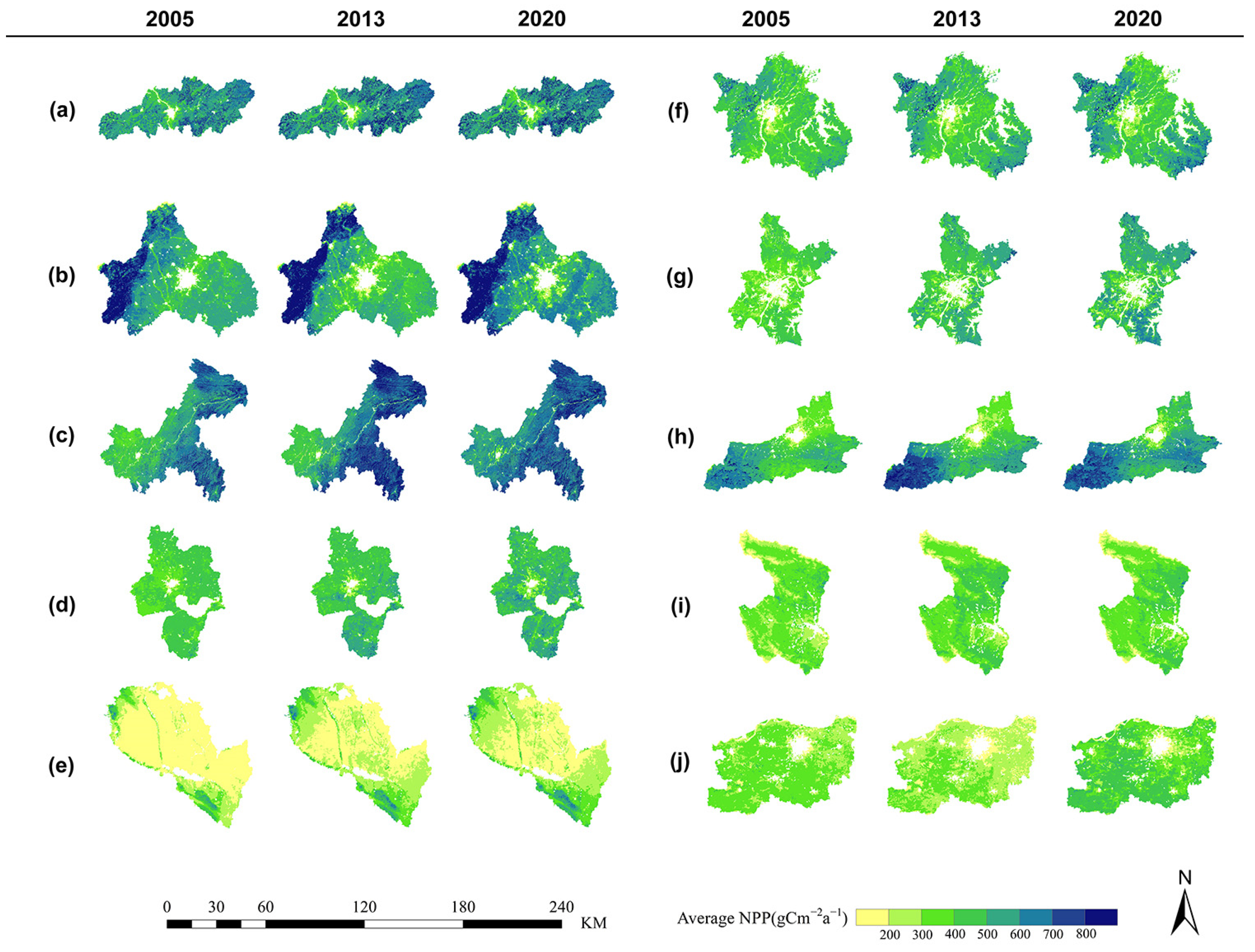
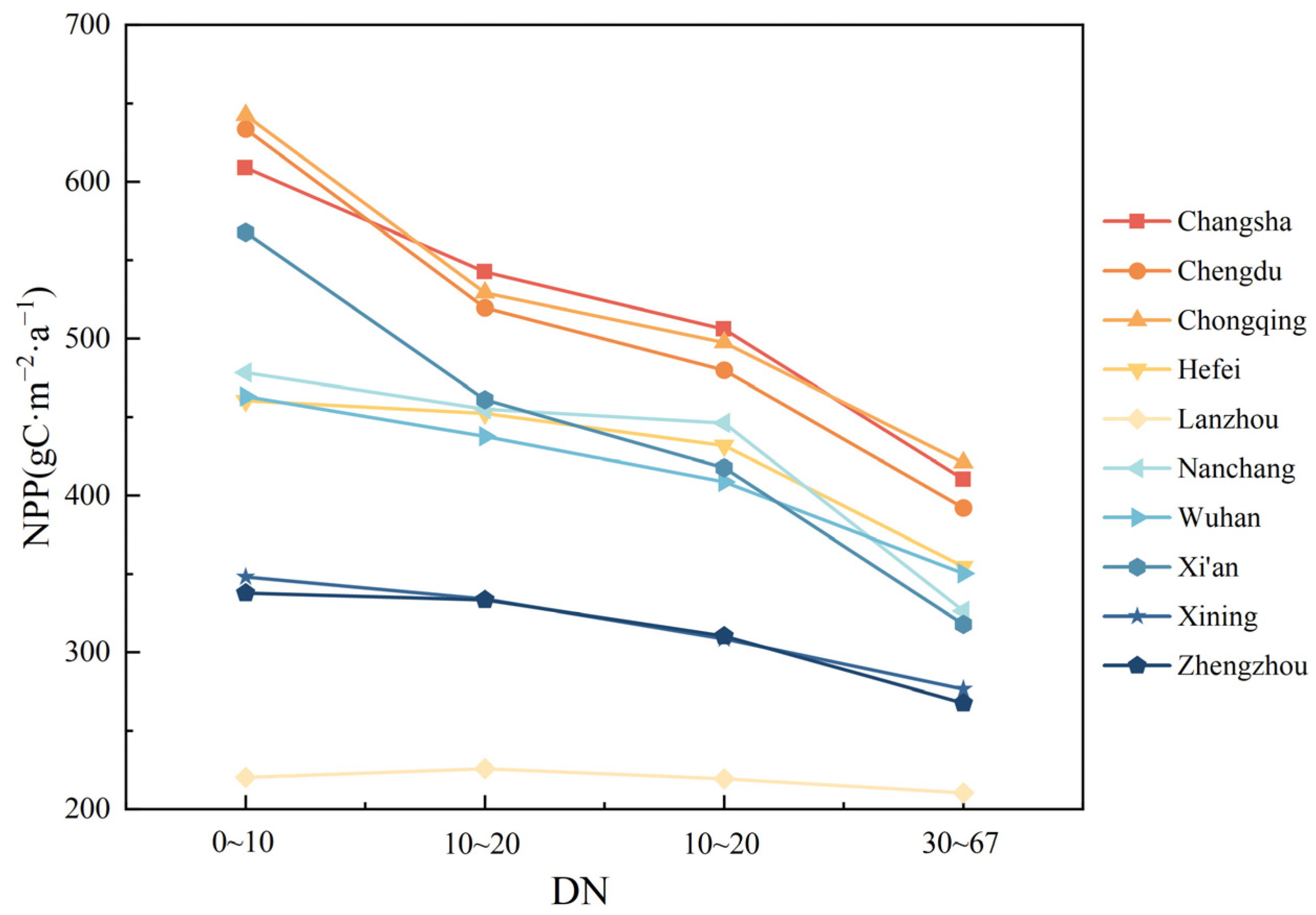
3.2. Temporal–Spatial Variations in Vegetation NPP in Each Node City

Figure 4 shows no significant variation in NPP spatial distribution in Hefei, Nanchang, Wuhan, Xining, or Zhengzhou. NPP distribution in Changsha, Chengdu, Chongqing, Lanzhou, and Xi’an is heterogeneous. NPP values in Changsha are greater in the east and west and lower in the center, and an area with an average NPP between 500~600 gCm−2a−1 accounting for 41.4% of the total area; places with less vegetation in central urban NPP are concentrated. The central and eastern regions of Chengdu have a concentrated area with NPP values ranging from 400 to 600 gCm−2a−1, which accounts for 59.29% of the entire area. This region belongs to the plain at the bottom of the Sichuan Basin, mainly composed of plains and some hills. The spatial distribution in Chongqing has higher values in the eastern region as opposed to the western region. The regions exhibiting high NPP are primarily located in the eastern and southeastern sectors, where the region with NPP values in the range of 600~800 gCm−2a−1 accounts for 49.37% of the total area. Regions exhibiting an NPP exceeding 800 gCm−2a−1 are scattered throughout the mountainous regions on the eastern edge, encompassing around 3% of the whole area. Lanzhou is situated within the arid grassland region of the western Loess Plateau, deep in the inland northwest of China. It is less affected by moist oceanic airflows, resulting in a generally dry climate throughout the year. The area with NPP values exceeding 400 gCm−2a−1 covers 0.068 square kilometers, accounting for only 5.2% of the entirety of Lanzhou, and is distributed in the higher elevation canyon areas in the northwest and southwest corners. The vegetation NPP in Xi’an City exhibits a pattern of low values in the northern region and high values in the southern region. Specifically, areas with NPP values ranging from 200–400 gCm−2a−1, 400–500 gCm−2a−1, and 500–600 gCm−2a−1 account for 19.8%, 30.54%, and 25.04% of the total area, respectively. NPP values are highest in southeastern Xi’an City.
Figure 5 illustrated the coefficient of variation for the ten nodal cities from 2005 to 2020. It was evident that, except for Lanzhou, the NPP variability in the remaining nine cities tended to be stable overall. In Lanzhou, more than 68.1% of the areas had coefficients exceeding 0.2, indicating instability. In Changsha and Xining, coefficients for 81% of the areas did not exceed 0.1, indicating changes within a very stable range. The coefficients for the urban construction areas of all cities exceeded 0.2, indicating unstable NPP changes.
Figure 6 depicts the temporal fluctuation pattern of NPP in ten cities along the Belt and Road, at a pixel scale, from 2005 to 2020. The proportion of land area occupied by various sorts of trends was computed in the 10 cities, and the distribution in space of NPP within each city exhibited significant spatial relevance and heterogeneity. From 2005 to 2020, vegetation NPP grew in most inland node cities of the “Belt and Road,” with each city’s rise exceeding 79%. Among them, Lanzhou has the highest proportion of the increased part, at 98.01%, following are Xi’an, Chengdu, and Chongqing, the results are 95.08%, 92.65%, and 89.94%, respectively. This matches earlier linear fitting results. The percentage of area in Lanzhou and Xi’an that showed a significant decrease was only 0.14% and 0.59%, respectively, indicating that the vegetation in Lanzhou and Xi’an was in a better condition in 16 years, and that the vegetation in the two cities produced a high content of organic matter; Chengdu and Chongqing show a highly significant decline in the area of 0.73 percent and 0.4 percent of the area, respectively, and these areas are located near urban areas, have high GDP levels, and are also affected by human activities and economic development, resulting in a highly significant decline in the NPP trend.

3.3. Examining the Effects of Several Influential Factors on NPP

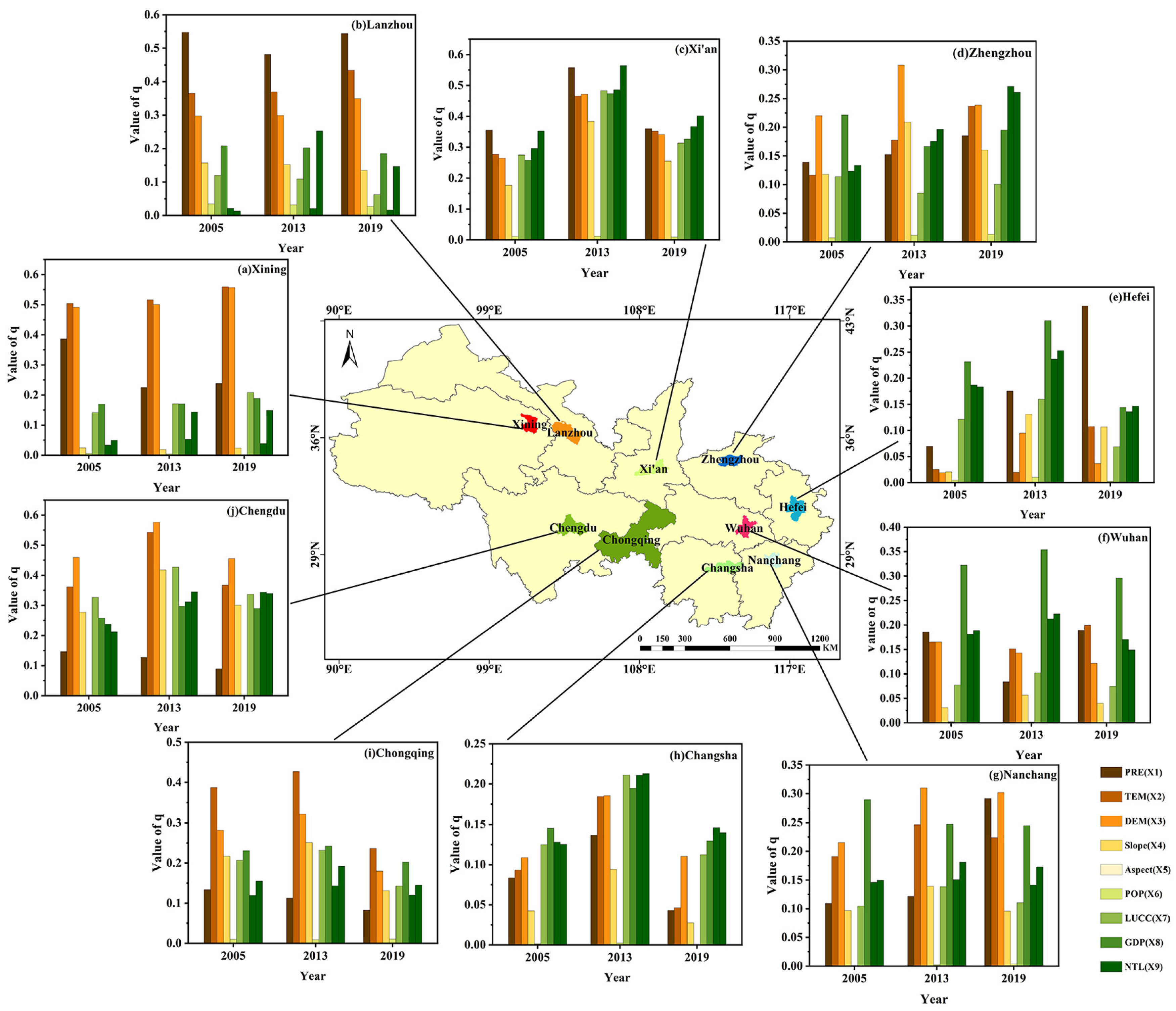
3.3.1. Identification of Crucial Variables

Factor detection in Geodetectors analyses q values to determine the spatial influence of driving variables on NPP. Figure 7 depicts the fluctuations related to the explanatory capacity of different driving factors on NPP for ten urban nodes in the years 2005, 2013, and 2019. due to the lack of GDP raster data for the year 2020, the analysis uses 2019 data. The driving factors are categorized into natural factors (PRE, TEM, DEM, Slope, Aspect) and anthropogenic factors (POP, LUCC, GDP, NTL). According to research analysis, we identified a strong link between anthropogenic causes and NPP in southeastern cities including Hefei, Wuhan, Nanchang, and Changsha, which suggests that in these cities, human activities, economic development, and urbanization affect the ecosystem significantly. Western study area cities, such as Xining, Lanzhou, Chengdu, and Chongqing, exhibit a correlation with NPP primarily influenced by natural factors, including precipitation, elevation, and temperature. Lanzhou’s precipitation shows the highest explanatory power, with precipitation being a major natural factor influencing vegetation growth and ecosystem health in this region. Chengdu demonstrates the greatest ability to explain the relationship between elevation and NPP, as changes in elevation may influence climate and vegetation distribution, thereby impacting NPP. Xining and Chongqing, on the other hand, show that temperature best explains NPP. Observing how natural variables affect NPP in all cities, the order of influence factors is arranged as follows based on their magnitude: DEM > TEM > PRE > Slope > Aspect.
In the northern region, Xi’an and Zhengzhou have seen a gradual dominance of the correlation with anthropogenic factors after 2013. Furthermore, the highest correlation exists between land use and nighttime light. In 2013, Xi’an achieved a 56% explanatory power for NPP through nighttime light. In all cities, it can be concluded that the spatial influence of slope orientation is relatively small and can even be considered a negligible factor.

3.3.2. Changes in Land Use Affect Vegetation NPP

Figure 8 depicts the NPP figures associated with various land use categories in the year 2005, 2013, and 2020. Overall, the NPP values of cropland in Wuhan and Zhengzhou exceed those of woodland, woodland has the greatest NPP values in eight cities, whereas unused land has the lowest in all ten. From 2013 onwards, the vegetation NPP values of cropland and building land in all cities have consistently increased. On the other hand, NPP values of other land use types have fluctuated but have generally remained at similar levels. In Zhengzhou, from 2013 to 2020, various land use types have shown a significant increasing trend, consistent with the previous analysis of NPP values for Zhengzhou from 2013 to 2020 (Figure 3j).
Table 4 displays the fluctuations in land use areas in inland node cities. It is evident that the building land area has experienced growth in all cities from 2013 to 2020, with Chongqing showing the highest increase of 317.5 km2. During the period from 2013 to 2020, woodland areas in seven cities generally experienced a decreasing trend. It is worth noting that, during the period after 2013, six cities achieved the opposite, successfully increasing woodland areas. These cities, while expanding woodland areas, successfully converted land originally used for cropland or grassland into woodland. The NPP values of woodland in most cities are generally higher than those of cropland or grassland. Additionally, with the steady increase in both construction land area and construction land NPP values in all cities, urban NPP values are further enhanced through this land conversion.

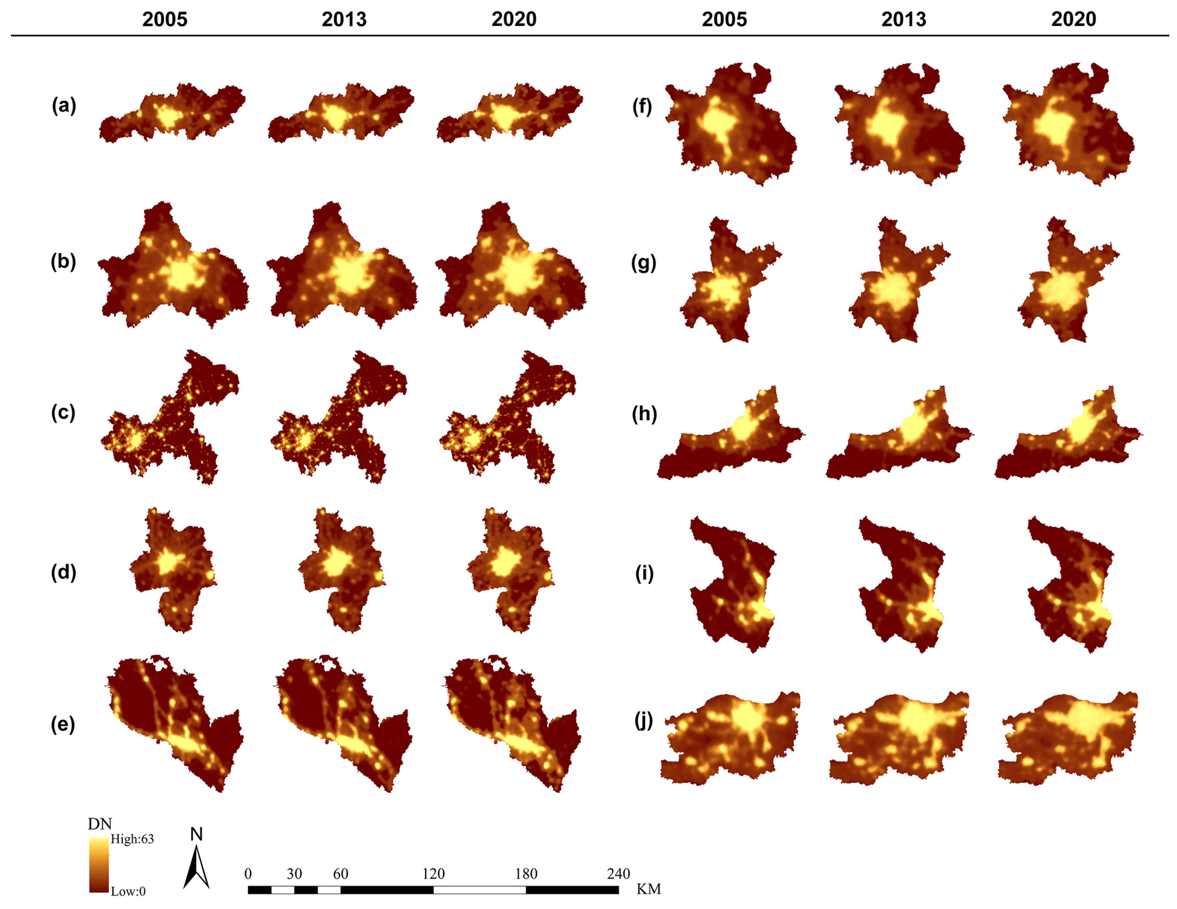
3.3.3. NTL Spatial Pattern and Its Relationship with NPP

Figure 9 presents the nighttime light data of various node cities. From a temporal perspective, comparing nighttime light values before and after 2013 indicates that all cities experienced a certain degree of urban expansion. Chongqing, Changsha, Hefei, Lanzhou, Nanchang, and Xining had over 80% of their areas with DN values of 0–10. Chengdu, Wuhan, and Xi’an had 65–80% of their areas with nighttime light DN values between 0–10, while Zhengzhou had over 50% of its area with DN values between 0–10. During the period from 2005 to 2013, the nighttime light data of each city showed a significant trend. Specifically, the area with DN values of 0–10 at night significantly decreased, and correspondingly, the area with DN values above 30 increased significantly. Chengdu, Chongqing, and Hefei stood out in the increase of nighttime light DN values, with Chengdu’s growth rate reaching 105.31%, Chongqing 116.9%, and Hefei 113.14%. After 2013, this trend of nighttime light change significantly slowed down.
Figure 10 presents the nighttime light data of various node cities. Areas with high nighttime light intensity are located in the city centers, where vegetation coverage is 0, and NPP values are close to zero. Figure 10 shows the variation of NPP values under different light intensities for each city, and it is evident that NPP values decrease with the increase of nighttime light values.

3.3.4. Interaction Analysis between Factors

Factor interaction analysis was performed on key driving factors in each city for the years 2005, 2013, and 2019. The results are presented in Figure 11. Across these three years, with the exception of Zhengzhou in 2013, all other cities exhibit a consistent trend. In particular, NPP impacted by two factors has a higher explanatory power (q value) than NPP influenced by one factor. These interactions can be classified as either two-factor enhancement or nonlinear enhancement. Further analysis reveals that for each city, it is more likely that the factor that best explains NPP will interact with other factors than they will interact with each other, as shown by the q number. Figure 11e clearly demonstrates that the impact of precipitation on the other parameters is considerably higher than the interaction between the other two components, and the same conclusion can be drawn from Figure 11g. Among the ten cities, Hefei and Lanzhou’s two-factor interaction type is dominated by nonlinear enhancement type, and the rest of the cities are dominated by two-factor enhancement. In the three years of 2005, 2013, and 2019, the combinations of factors with higher explanatory power were selected from natural and anthropogenic factors, and the analysis found that the cities of Hefei, Lanzhou, Wuhan, and Xining were significantly affected by the interaction of PRE and LUCC, and the cities of Changsha, Nanchang, Xining, and Zhengzhou were significantly affected by the interaction of DEM and LUCC.

4. Discussion

4.1. NPP Temporal and Spatial Changes

Over the past decade, significant changes have occurred in the vegetation NPP of ten cities. Analyzing the spatiotemporal variations in vegetation NPP from 2005 to 2020, the annual average vegetation NPP for inland node cities is 458.29 gCm−2a−1, based on previous studies on national NPP [45,46]; this value is lower than the national average. During the implementation phase of the BRI, there have been certain differences in the policy execution capabilities among different cities [47]. For instance, Chongqing Municipality, with a relatively higher economic level, has introduced “Chongqing’s Full Integration into the 14th Five-Year Plan (2021–2025) to Jointly Build the Belt and Road and Accelerate the Construction of Inland Open Highlands”. This document places high importance on the development of high-quality economy and green initiatives (https://www.cq.gov.cn, accessed on 11 March 2024), aiming to enhance the level of industrial openness and construct an international gateway hub city with global influence. On the other hand, Lanzhou, with a lower level of economic development, focuses more on prioritizing the improvement of infrastructure construction first. By opening multiple air and railway ports, this process makes it possible to enter the markets of both Central Asia and the Middle East (https://www.lanzhou.gov.cn, accessed on 11 March 2024). The differences in development patterns among different cities lead to disparities in economic levels between them. In economically advanced cities like Chongqing, where infrastructure is more developed, there is a focus on green, high-quality development. The improvement of economic levels can also enhance the construction of a green ecological civilization [48]. On the other hand, in economically less advanced cities like Lanzhou, the emphasis is on infrastructure construction and changes in land planning and utilization, which will have profound impacts on the structure of natural ecosystems [49,50]. It is worth noting from Table 3 that Lanzhou, which has the lowest average NPP, has the highest NPP growth rate of 26.57%. This may be because while Lanzhou focuses on urban construction, it also emphasizes green development within the city. It actively implements political decisions, develops clean energy, and accelerates the transformation of enterprises to green. It also promotes land restoration by turning farms into forests and grasslands.
Secondly, considering the significant differences in natural conditions between different cities, there are huge differences in the thermal properties of land and sea in these ten cities, and the morphological distribution of vegetation is closely related to the distribution pattern of precipitation [51], leading to the formation of different vegetation types in different cities. These two factors together result in significant differences in vegetation NPP between cities. Specifically, NPP in southern cities tends to be higher compared to that in northern ones, which aligns with the nationwide trend of higher vegetation NPP values in southern cities compared to northern cities [52]. Xining City, Zhengzhou City, and Lanzhou City are below the average level of vegetation NPP of inland node cities, and all three cities are located in the north of the economic belt; Nanchang City, Wuhan City, and Hefei City are basically in the average level of vegetation NPP of inland node cities; Xining City, Zhengzhou City, and Lanzhou City are below the average level of vegetation NPP.
Overall, considering all aspects, the vegetation NPP of inland node cities along the BRI in China has shown a gradual upward trend from 2005 to 2020 [53]. Combining Figure 3 and Table 3, it is evident that the vegetation NPP values of various node cities have increased from 2013 to 2020 compared to the period from 2005 to 2012. Based on existing studies [54,55,56] and the NPP trend analyzed in this paper, it is anticipated that NPP will continue to show an increasing trend in the future. This may be related to various policy guidelines introduced by the government during the BRI; for example, the document titled “Vision and Actions on Jointly Building Silk Road Economic Belt and 21st-Century Maritime Silk Road” was published in 2015. This paper expressly highlights the enhancement of infrastructure by implementing environmentally friendly and low-carbon construction and operation management practices. It also takes into full account the influence of climate change during the development process (http://2017.beltandroadforum.org/n100/2017/0407/c27-22.html, accessed on 9 October 2023). Furthermore, it encourages active collaboration in the development of clean and sustainable energy sources, including wind, solar, etc. The “Chair’s Statement of the Third Belt and Road Forum for International Cooperation”, which came out in 2023, said that Green Development International Alliance needed more help (https://www.gov.cn, accessed on 12 March 2024). It also highlights the continuation of the Green Innovation Conference and the establishment of mechanisms for dialogue and exchange in the solar photovoltaic industry, as well as a network of green and low-carbon experts. The document “Vision and Actions for Deepening and Achieving High-quality Development Along the Belt and Road—Development Outlook for the Belt and Road in the Next Decade” advocates for the integration of environmentally friendly practices as a prominent aspect of the Belt and Road construction (https://www.gov.cn, accessed on 12 March 2024). It highlights the importance of achieving balanced progress in the economy, society, and environmental conservation.

4.2. Variation in the NPP Caused by Driving Factors

NPP fluctuations are impacted by a range of sources, including natural, anthropogenic, and other variables. Our analysis revealed substantial regional variability in the drivers of NPP in the ten cities. Analysis from Figure 7 indicates that the changes and spatial distribution of NPP in regions with higher GDP levels are more significantly influenced by anthropogenic factors compared to natural factors. This could be attributed to the significant human activities and economic development in regions with high GDP, and the rapid growth of GDP has a positive effect on land cover change [57], which explains to a certain extent that the influence of LUCC is ranked at the top of the list among high GDP cities, along with the rapid development and urbanization of cities, human factors inevitably become the dominant factor in the change of NPP [27]. Analysis of land cover changes in inland node cities under the background of the BRI reveals different spatial patterns in each city. Chengdu, Chongqing, Changsha, and Xi’an are mainly covered by forests, while Wuhan, Nanchang, Hefei, and Zhengzhou are dominated by farmland. Xining and Lanzhou are covered by grassland. However, various degrees of transformation from forests, farmland, and grassland to urban land are observed. Additional research can further investigate the influence of alterations in land use on NPP. Different cities have different urban planning, leading to variations in land types. Urban development necessitates a heightened emphasis on the creation of green spaces within cities to mitigate the significant deterioration of the ecological environment.
DEM is the main natural factor influencing vegetation NPP in the cities of Nanchang, Changsha, Chengdu, and Zhengzhou, with a maximum explanatory power of up to 57.6%. Interestingly, when combining the DEM remote sensing images of each city, it is observed that areas with higher elevation generally have higher NPP values. The observed phenomenon can be ascribed to the impact of altitude on both temperature and precipitation [58]. It is well known that temperature decreases with increasing altitude, while precipitation increases with higher elevations. However, NPP does not consistently increase with elevation. The growth of vegetation has a threshold [29], and when a certain height is reached, vegetation decreases, resulting in a corresponding decrease in NPP. This paper did not quantify the optimal elevation range for urban vegetation NPP, which could be explored in future research. The Geodetector interaction detection results demonstrate that the combined influence of any two factors is more significant than the effect of a single element. This is consistent with previous research [59,60], and all interactions exhibit either single-factor enhancement or nonlinear enhancement. When discussing the future elements that drive vegetation NPP, consideration should not be limited to single-factor effects but should also encompass the comprehensive effects of multiple-factor interactions.

4.3. Limitations and Prospects

Our study has significant value. Studying the fluctuating patterns of vegetation NPP and the factors that influence it is a task that requires a significant amount of time and effort. especially when exploring the temporal variations before and after a specific time point. Such investigations often require a longer duration to identify patterns. For this analysis, we exclusively utilized data from the time period spanning 2005 to 2020, which to some extent limits the persuasiveness of the findings and fails to reflect recent ecological environmental quality. This constraint makes it more difficult to conduct an examination of the relationship between the NPP of vegetation and the factors that influence it. The data in our study relies on remote sensing data, and there is a lack of GDP grid data for the year 2020. As a substitute, we used data from 2019, which introduced additional uncertainties to the study. Currently, the data resolution we employed is based on 500 m. In future studies, we recommend conducting analyses based on higher resolutions and longer time periods to achieve a more refined study. While focusing on domestic nodal cities, equal consideration should be directed towards the major cities of other nations along the Belt and Road, enabling long-term ecological research on the BRI and scientific basis for high-quality urban planning.

5. Conclusions

This study employed a series of analytical methods including geographical detectors to investigate the changes in vegetation NPP before and after the proposal of the BRI in ten inland hub cities in China, including Chongqing. The ideal model was used to objectively analyses numerous aspects and analyze how land use change and GDP levels affect NPP. Simultaneously, it explored the interactions among different influencing factors. This study shows how the ecological quality of ten Chinese towns changed before and after the BRI was put into place, and how those changes affected economic growth. Through the analysis of the spatiotemporal changes in vegetation NPP of the ten cities, it was found that from 2005 to 2020, the yearly average vegetation NPP went up over time. After the BRI was proposed, the annual average vegetation NPP in every city was higher than it had been for eight years. This indicates that during the BRI, the environment is gradually improving in all countries and the green concept is working well. In the absence of extreme climatic and other uncontrollable factors in the future, the growth rate of NPP in the future ten cities will be faster. Due to geographical and economic differences among different cities, targeted strategies should be formulated to increase vegetation NPP. In economically developed areas, the urban construction land area corresponding to the cities increases year by year. In the future, further strengthening urban ecological civilization construction and increasing urban vegetation coverage are key to improving vegetation NPP levels. In economically underdeveloped areas, the dominant factor affecting NPP is natural factors, strengthening water resource management, vigorously improving water conditions, and regulating local microclimates will effectively increase NPP levels.

Author Contributions

Conceptualization, G.L., J.P., Y.J., X.Y. and F.S.; methodology, G.L. and J.P.; software, G.L., Y.J., X.Y. and F.S.; validation, G.L., Y.J., X.Y. and F.S.; formal analysis, G.L.; investigation, G.L.; resources, J.P.; data curation, G.L., Y.J., X.Y. and F.S.; writing—original draft preparation, G.L.; writing—review and editing, G.L.; visualization, G.L.; supervision, J.P.; project administration, J.P.; funding acquisition, J.P. The final draft of the work has been carefully examined by all authors, who have all authorized its publication. All authors have read and agreed to the published version of the manuscript.

Funding

This research received support from the Jiangsu Forestry Science and Technology Innovation and Promotion Project, grant number LYKJ [2021]14, as well as the National Natural Science Foundation of China, grant number 31470579.

Institutional Review Board Statement

Not applicable.

Informed Consent Statement

Not applicable.

Data Availability Statement

The study results are fully detailed in the text, and should further data be required, it can be obtained from the corresponding author.

Conflicts of Interest

There are no conflicts of interest in this study.

References

  1. Shang, H. What Is the Belt and Road Initiative? Springer: Berlin/Heidelberg, Germany, 2019. [Google Scholar]
  2. Zeng, L. Conceptual analysis of China’s belt and road initiative: A road towards a regional community of common destiny. In Contemporary International Law and China’s Peaceful Development; Springer: Berlin/Heidelberg, Germany, 2021; pp. 305–331. [Google Scholar]
  3. Mierzejewski, D. China’s Provinces and the Belt and Road Initiative; Routledge: London, UK; New York, NY, USA, 2021. [Google Scholar]
  4. Zou, Y.-F.; Deng, M.; Li, Y.J.; Yao, R. Evolution characteristics and policy implications of new urbanization in provincial capital cities in Western China. PLoS ONE 2020, 15, e0233555. [Google Scholar]
  5. Smith, N.R. Continental metropolitanization: Chongqing and the urban origins of China’s Belt and Road Initiative. Urban Geogr. 2022, 43, 1544–1564. [Google Scholar] [CrossRef]
  6. Davis, K. The urbanization of the human population. In The City Reader; Routledge: London, UK; New York, NY, USA, 2015; pp. 43–53. [Google Scholar]
  7. Zhang, X.Q. The trends, promises and challenges of urbanisation in the world. Habitat Int. 2016, 54, 241–252. [Google Scholar] [CrossRef]
  8. Chhabra, A.; Geist, H.; Houghton, R.A.; Haberl, H.; Braimoh, A.K.; Vlek, P.L.; Patz, J.; Xu, J.; Ramankutty, N.; Coomes, O. Multiple impacts of land-use/cover change. In Land-Use and Land-Cover Change: Local Processes and Global Impacts; Springer: Berlin/Heidelberg, Germany, 2006; pp. 71–116. [Google Scholar]
  9. Maparu, T.S.; Mazumder, T.N. Transport infrastructure, economic development and urbanization in India (1990–2011): Is there any causal relationship? Transp. Res. Part A Policy Pract. 2017, 100, 319–336. [Google Scholar] [CrossRef]
  10. Bernhardt, E.S.; Palmer, M.A. Restoring streams in an urbanizing world. Freshw. Biol. 2007, 52, 738–751. [Google Scholar] [CrossRef]
  11. Devanathan, P.; Devanathan, K. Heat island effects. In Green Building with Concrete: Sustainable Design Construction; CRC Press: Boca Raton, FL, USA, 2011; pp. 175–226. [Google Scholar]
  12. Imhoff, M.L.; Bounoua, L.; DeFries, R.; Lawrence, W.T.; Stutzer, D.; Tucker, C.J.; Ricketts, T. The consequences of urban land transformation on net primary productivity in the United States. Remote Sens. Environ. 2004, 89, 434–443. [Google Scholar] [CrossRef]
  13. Friend, A.D. Terrestrial plant production and climate change. J. Exp. Bot. 2010, 61, 1293–1309. [Google Scholar] [CrossRef]
  14. Liu, X.; Wang, S.; Wu, P.; Feng, K.; Hubacek, K.; Li, X.; Sun, L. Impacts of urban expansion on terrestrial carbon storage in China. Environ. Sci. Technol. 2019, 53, 6834–6844. [Google Scholar] [CrossRef]
  15. Ministry of Foreign Affairs of the People’s Republic of China. Available online: https://www.fmprc.gov.cn/eng/topics_665678/2015zt/xjpcxbayzlt2015nnh/201503/t20150328_705553.html (accessed on 20 October 2023).
  16. Li, W.; Wang, Y.; Xie, S.; Cheng, X. Coupling coordination analysis and spatiotemporal heterogeneity between urbanization and ecosystem health in Chongqing municipality, China. Sci. Total Environ. 2021, 791, 148311. [Google Scholar] [CrossRef]
  17. Ariken, M.; Zhang, F.; weng Chan, N. Coupling coordination analysis and spatio-temporal heterogeneity between urbanization and eco-environment along the Silk Road Economic Belt in China. Ecol. Indic. 2021, 121, 107014. [Google Scholar] [CrossRef]
  18. Zhao, S.; Yan, Y.; Han, J. Industrial land change in Chinese Silk Road cities and its influence on environments. Land 2021, 10, 806. [Google Scholar] [CrossRef]
  19. Wu, D.; Zheng, L.; Wang, Y.; Gong, J.; Li, J.; Chen, Q. Characteristics of urban expansion in megacities and its impact on water-related ecosystem services: A comparative study of Chengdu and Wuhan, China. Ecol. Indic. 2024, 158, 111322. [Google Scholar] [CrossRef]
  20. Colsaet, A.; Laurans, Y.; Levrel, H. What drives land take and urban land expansion? A systematic review. Land Use Policy 2018, 79, 339–349. [Google Scholar] [CrossRef]
  21. Bhattacharyay, B.N. Seamless sustainable transport connectivity in Asia and the Pacific: Prospects and challenges. Int. Econ. Econ. Policy 2012, 9, 147–189. [Google Scholar] [CrossRef]
  22. Gao, Y.; Zhou, X.; Wang, Q.; Wang, C.; Zhan, Z.; Chen, L.; Yan, J.; Qu, R. Vegetation net primary productivity and its response to climate change during 2001–2008 in the Tibetan Plateau. Sci. Total Environ. 2013, 444, 356–362. [Google Scholar] [CrossRef] [PubMed]
  23. Zhong, J.; Jiao, L.; Droin, A.; Liu, J.; Lian, X.; Taubenböck, H. Greener cities cost more green: Examining the impacts of different urban expansion patterns on NPP. Build. Environ. 2023, 228, 109876. [Google Scholar] [CrossRef]
  24. Chen, C.; Zhang, C. Projecting the CO2 and climatic change effects on the net primary productivity of the urban ecosystems in phoenix, AZ in the 21st century under multiple RCP (representative concentration pathway) scenarios. Sustainability 2017, 9, 1366. [Google Scholar] [CrossRef]
  25. Roxburgh, S.; Berry, S.L.; Buckley, T.; Barnes, B.; Roderick, M. What is NPP? Inconsistent accounting of respiratory fluxes in the definition of net primary production. Funct. Ecol. 2005, 19, 378–382. [Google Scholar] [CrossRef]
  26. Xiao, J.; Chevallier, F.; Gomez, C.; Guanter, L.; Hicke, J.A.; Huete, A.R.; Ichii, K.; Ni, W.; Pang, Y.; Rahman, A.F. Remote sensing of the terrestrial carbon cycle: A review of advances over 50 years. Remote Sens. Environ. 2019, 233, 111383. [Google Scholar] [CrossRef]
  27. Wei, X.; Yang, J.; Luo, P.; Lin, L.; Lin, K.; Guan, J. Assessment of the variation and influencing factors of vegetation NPP and carbon sink capacity under different natural conditions. Ecol. Indic. 2022, 138, 108834. [Google Scholar] [CrossRef]
  28. Kobler, J.; Zehetgruber, B.; Dirnböck, T.; Jandl, R.; Mirtl, M.; Schindlbacher, A. Effects of aspect and altitude on carbon cycling processes in a temperate mountain forest catchment. Landsc. Ecol. 2019, 34, 325–340. [Google Scholar] [CrossRef]
  29. Wang, Y.; Zhang, Z.; Chen, X. Quantifying influences of natural and anthropogenic factors on vegetation changes based on geodetector: A case study in the Poyang Lake Basin, China. Remote Sens. 2021, 13, 5081. [Google Scholar] [CrossRef]
  30. Aithal, B.H.; Ramachandra, T. Urban Growth Patterns in India: Spatial Analysis for Sustainable Development; CRC Press: Boca Raton, FL, USA, 2020. [Google Scholar]
  31. Wang, C.; Myint, S.W.; Fan, P.; Stuhlmacher, M.; Yang, J. The impact of urban expansion on the regional environment in Myanmar: A case study of two capital cities. Landsc. Ecol. 2018, 33, 765–782. [Google Scholar] [CrossRef]
  32. Gang, C.; Zhou, W.; Chen, Y.; Wang, Z.; Sun, Z.; Li, J.; Qi, J.; Odeh, I. Quantitative assessment of the contributions of climate change and human activities on global grassland degradation. Environ. Earth Sci. 2014, 72, 4273–4282. [Google Scholar] [CrossRef]
  33. Liu, X.; Pei, F.; Wen, Y.; Li, X.; Wang, S.; Wu, C.; Cai, Y.; Wu, J.; Chen, J.; Feng, K. Global urban expansion offsets climate-driven increases in terrestrial net primary productivity. Nat. Commun. 2019, 10, 5558. [Google Scholar] [CrossRef] [PubMed]
  34. Wu, Y.; Wu, Z. Quantitative assessment of human-induced impacts based on net primary productivity in Guangzhou, China. Environ. Sci. Pollut. Res. 2018, 25, 11384–11399. [Google Scholar] [CrossRef]
  35. Yang, H.; Hu, D.; Xu, H.; Zhong, X. Assessing the spatiotemporal variation of NPP and its response to driving factors in Anhui province, China. Environ. Sci. Pollut. Res. 2020, 27, 14915–14932. [Google Scholar] [CrossRef]
  36. Wang, G.; Peng, W.; Zhang, L.; Zhang, J. Quantifying the impacts of natural and human factors on changes in NPP using an optimal parameters-based geographical detector. Ecol. Indic. 2023, 155, 111018. [Google Scholar] [CrossRef]
  37. Song, Y.; Wang, J.; Ge, Y.; Xu, C. An optimal parameters-based geographical detector model enhances geographic characteristics of explanatory variables for spatial heterogeneity analysis: Cases with different types of spatial data. GIScience Remote Sens. 2020, 57, 593–610. [Google Scholar] [CrossRef]
  38. Yang, J.; Huang, X. The 30 m annual land cover dataset and its dynamics in China from 1990 to 2019. Earth Syst. Sci. Data 2021, 13, 3907–3925. [Google Scholar] [CrossRef]
  39. Chen, J.; Gao, M.; Cheng, S.; Hou, W.; Song, M.; Liu, X.; Liu, Y. Global 1 km× 1 km gridded revised real gross domestic product and electricity consumption during 1992–2019 based on calibrated nighttime light data. Sci. Data 2022, 9, 202. [Google Scholar] [CrossRef] [PubMed]
  40. Zhang, L.; Ren, Z.; Chen, B.; Gong, P.; Fu, H.; Xu, B. A Prolonged Artificial Nighttime-Light Dataset of China (1984–2020); National Tibetan Plateau Data Center: Beijing, China, 2021. [Google Scholar]
  41. Theil, H. A rank-invariant method of linear and polynomial regression analysis. Indag. Math. 1950, 12, 173. [Google Scholar]
  42. Mann, H.B. Nonparametric tests against trend. Econom. J. Econom. Soc. 1945, 13, 245–259. [Google Scholar] [CrossRef]
  43. Jalilibal, Z.; Amiri, A.; Castagliola, P.; Khoo, M.B. Monitoring the coefficient of variation: A literature review. Comput. Ind. Eng. 2021, 161, 107600. [Google Scholar] [CrossRef]
  44. Wang, J.-F.; Zhang, T.-L.; Fu, B.-J. A measure of spatial stratified heterogeneity. Ecol. Indic. 2016, 67, 250–256. [Google Scholar] [CrossRef]
  45. Shi, S.; Zhu, L.; Luo, Z.; Qiu, H. Quantitative analysis of the contributions of climatic and anthropogenic factors to the variation in net primary productivity, China. Remote Sens. 2023, 15, 789. [Google Scholar] [CrossRef]
  46. Ji, Y.; Zhou, G.; Luo, T.; Dan, Y.; Zhou, L.; Lv, X. Variation of net primary productivity and its drivers in China’s forests during 2000–2018. For. Ecosyst. 2020, 7, 1–11. [Google Scholar] [CrossRef]
  47. Jiang, Q.; Ma, X.; Wang, Y. How does the one belt one road initiative affect the green economic growth? Energy Econ. 2021, 101, 105429. [Google Scholar] [CrossRef]
  48. Hu, J.; Hu, M.; Zhang, H. Has the construction of ecological civilization promoted green technology innovation? Environ. Technol. Innov. 2023, 29, 102960. [Google Scholar] [CrossRef]
  49. Kelly, C.; Ferrara, A.; Wilson, G.A.; Ripullone, F.; Nolè, A.; Harmer, N.; Salvati, L. Community resilience and land degradation in forest and shrubland socio-ecological systems: Evidence from Gorgoglione, Basilicata, Italy. Land Use Policy 2015, 46, 11–20. [Google Scholar] [CrossRef]
  50. Clerici, N.; Paracchini, M.L.; Maes, J. Land-cover change dynamics and insights into ecosystem services in European stream riparian zones. Ecohydrol. Hydrobiol. 2014, 14, 107–120. [Google Scholar] [CrossRef]
  51. Fang, J.; Piao, S.; Zhou, L.; He, J.; Wei, F.; Myneni, R.B.; Tucker, C.J.; Tan, K. Precipitation patterns alter growth of temperate vegetation. Geophys. Res. Lett. 2005, 32, L21411. [Google Scholar] [CrossRef]
  52. Liang, W.; Yang, Y.; Fan, D.; Guan, H.; Zhang, T.; Long, D.; Zhou, Y.; Bai, D. Analysis of spatial and temporal patterns of net primary production and their climate controls in China from 1982 to 2010. Agric. For. Meteorol. 2015, 204, 22–36. [Google Scholar] [CrossRef]
  53. Ge, W.; Deng, L.; Wang, F.; Han, J. Quantifying the contributions of human activities and climate change to vegetation net primary productivity dynamics in China from 2001 to 2016. Sci. Total Environ. 2021, 773, 145648. [Google Scholar] [CrossRef] [PubMed]
  54. Yuan, Q.; Wu, S.; Dai, E.; Zhao, D.; Ren, P.; Zhang, X. NPP vulnerability of the potential vegetation of China to climate change in the past and future. J. Geogr. Sci. 2017, 27, 131–142. [Google Scholar] [CrossRef]
  55. Zhou, Z.; Qin, D.; Chen, L.; Jia, H.; Yang, L.; Dai, T. Novel model for NPP prediction based on temperature and land use changes: A case in Sichuan and Chongqing, China. Ecol. Indic. 2022, 145, 109724. [Google Scholar] [CrossRef]
  56. Gao, J.; Jiao, K.; Wu, S.; Ma, D.; Zhao, D.; Yin, Y.; Dai, E. Past and future effects of climate change on spatially heterogeneous vegetation activity in China. Earth’s Future 2017, 5, 679–692. [Google Scholar] [CrossRef]
  57. Dewan, A.M.; Yamaguchi, Y. Land use and land cover change in Greater Dhaka, Bangladesh: Using remote sensing to promote sustainable urbanization. Appl. Geogr. 2009, 29, 390–401. [Google Scholar] [CrossRef]
  58. Zhang, Y.; Xu, M.; Chen, H.; Adams, J. Global pattern of NPP to GPP ratio derived from MODIS data: Effects of ecosystem type, geographical location and climate. Glob. Ecol. Biogeogr. 2009, 18, 280–290. [Google Scholar] [CrossRef]
  59. Wang, Y.; Tang, J.; Wang, W.; Wang, Z.; Wang, J.; Liang, S.; Chu, B. Long-Term Spatiotemporal Characteristics and Influencing Factors of Dust Aerosols in East Asia (2000–2022). Remote Sens. 2024, 16, 318. [Google Scholar] [CrossRef]
  60. Peng, W.; Fan, Z.; Duan, J.; Gao, W.; Wang, R.; Liu, N.; Li, Y.; Hua, S. Assessment of interactions between influencing factors on city shrinkage based on geographical detector: A case study in Kitakyushu, Japan. Cities 2022, 131, 103958. [Google Scholar] [CrossRef]
Figure 1. Location of the study area.
Sustainability 16 04845 g001
Figure 2. Average NPP value of inland node cities of the Belt and Road, 2005–2020.
Sustainability 16 04845 g002
Figure 3. Time series variation of NPP in inland node cities of the Belt and Road. Note: The blue solid line represents the NPP trend from 2005 to 2020, while the solid red and green lines depict the trends in NPP for the periods 2005–2013 and 2013–2020. The red line indicates an upward trend, while the green line indicates a downward trend.
Sustainability 16 04845 g003
Figure 4. Spatial changes of NPP in inland node cities of the Belt and Road in 2005, 2013 and 2020. (a) Changsha (b) Chengdu (c) Chongqing (d) Hefei (e) Lanzhou (f) Nanchang (g) Wuhan (h) Xi’an (i) Xining (j) Zhengzhou.
Sustainability 16 04845 g004
Figure 5. The spatial distribution of the coefficient of variation in ten nodal cities.
Sustainability 16 04845 g005
Figure 6. The NPP trend changes in inland node cities of the Belt and Road from 2005 to 2020.
Sustainability 16 04845 g006
Figure 7. The variation in the explanatory power (q values) of each driving factor in inland node cities in 2005, 2013, and 2019. Note: In the figure, PRE represents precipitation, TEM represents temperature, DEM represents digital elevation model, POP represents population density, LUCC represents land use, GDP represents gross domestic product, and NTL represents nighttime lighting.
Sustainability 16 04845 g007
Figure 8. Variations in NPP across different land types in inland node cities of the Belt and Road (a) Chengdu (b) Chongqing (c) Changsha (d) Hefei (e) Lanzhou (f) Nanchang (g) Wuhan (h) Xi’an (i) Xining (j) Zhengzhou.
Sustainability 16 04845 g008
Figure 9. Changes of nighttime lighting DN values in the inland node cities of the Belt and Road in 2005, 2013 and 2020 (a) Changsha (b) Chengdu (c) Chongqing (d) Hefei (e) Lanzhou (f) Nanchang (g) Wuhan (h) Xi’an (i) Xining (j) Zhengzhou. Note: DN stands for light gray value.
Sustainability 16 04845 g009
Figure 10. Changes in NPP under different nighttime light data in various Belt and Road node cities. Note: DN stands for light gray value.
Sustainability 16 04845 g010
Figure 11. Analysis of the interaction detection of driving factors in inland node cities for the years 2005, 2013, 2019. Note: “*” “**” represent the types of interactions as bivariate enhancement and nonlinear enhancement, respectively.
Sustainability 16 04845 g011
Table 1. The definition and origin of each dataset.
Data TypeDataDefinitionSource
Climate dataMonthly precipitationMonthly precipitation dataset for China, covering a distance of 1 kmChina Meteorological Data Sharing Network
Monthly mean temperature1-km monthly China mean temperature data
Human dataNighttime lights dataGlobal nighttime light dataNational Tibetan Plateau Data Center
Gross domestic product (GDP)Worldwide revised real gross domestic product measured on a grid with dimensions of 1 km × 1 kmFigshare data sharing platform
Population density data1-km spatial distribution of population density in China, 2005–2020WorldPop datasets
Land use dataMCD12Q1 version 6.1 has a time resolution of 1 year and a spatial resolution of 500 m × 500 mLPDACC’s public data pools
Vegetation dataNet primary productivity (NPP)MOD17A3HGF 6.1 product for the years 2005 to 2020
Topography dataDigital elevation model (DEM)The ASTER GDEM data has a spatial resolution of 30 m × 30 mGeographic Spatial Data Cloud
Slopeextracted from the DEM dataset
Aspect
Table 2. The Theil-Sen trend analysis and Mann–Kendall test results are classified.
SlopeTTrend Grading
S l o p e > 0 2.58 T extremely significant increase
1.96 T < 2.58 significant increase
1.65 T < 1.96 least-significant increase
T < 1.65 non-significant increase
S l o p e = 0 Tno change
S l o p e < 0 T < 1.65 non-significant decrease
1.65 T < 1.96 least-significant decrease
1.96 T < 2.58 significant decrease
2.58 T extremely significant decrease
Table 3. Changes in NPP of vegetation in inland cities connected to the BRI.
CityAnnual Mean Vegetation NPP (gCm−2a−1)Growth Rate
2005–20122013–2020
Changsha565.74598.835.85%
Chengdu545.02627.4315.12%
Chongqing601.32656.479.17%
Hefei438.80472.847.76%
Lanzhou197.95250.5526.57%
Nanchang454.83481.825.93%
Wuhan417.24458.509.89%
Xi’an499.45540.668.25%
Xining338.33351.974.03%
Zhengzhou327.36340.654.06%
Table 4. Changes in land type areas in ten city, 2005–2013 and 2013–2020.
TimeCityLand Use Type Area Change/(km2)
Forest LandGrass LandCultivated LandWater AreaUnused LandConstruction Land
2005–2013Chengdu568−125.25−695.7522.250.75230
Chongqing658.25−45.75−849109−65.75193.25
Changsha−61.50.75−7.25−70.2574.75
Hefei−333−10.7551.5−7.75−0.2550.25
Lanzhou3.5−6.7544.54.75−47.751.75
Nanchang−155.5−24165.75−33.75−1.7549.25
Wuhan−57.7516.25263−28.5−10.567.5
Xi’an−96.545.2528.51.750.7520.25
Xining−30.5329.75−303.255−10
Zhengzhou−106140.5−100.750.513.2552.5
2013–2020Chengdu−149−179.2543.75−5.75−2.5292.75
Chongqing−128.2511.75−225.543.5−19317.5
Changsha−260.75−24238.5−1−1.2548.5
Hefei567.574.25−49210.75−0.590
Lanzhou45.5−8047.5−9−51
Nanchang−104.7544−16.7518.751.557.25
Wuhan632.2579.5−878.2592.75−1.575.25
Xi’an241−49.25−231.75−0.75−0.541.25
Xining69.2553.5−125.25−2.753.751.5
Zhengzhou441.25−58.75−472.25−1.5−9.75101
Disclaimer/Publisher’s Note: The statements, opinions and data contained in all publications are solely those of the individual author(s) and contributor(s) and not of MDPI and/or the editor(s). MDPI and/or the editor(s) disclaim responsibility for any injury to people or property resulting from any ideas, methods, instructions or products referred to in the content.

