Abstract
Urban Green Infrastructures (UGIs) have gained increasing relevance in the field of climate adaptive design because of their capacity to provide regulating ecosystem services apt to respond to the impacts of global warming with short-term strategies. The effectiveness of UGIs in reducing climate risks depends on both the state of natural resources and the understanding of urban ecosystem processes over time. The implementation of analytic methods to better understand urban ecosystem dynamics, as well as the local effective potential of ESs, is crucial for addressing climate impacts in cities. The advances in remote sensing methodologies for mapping and monitoring urban ecosystems represent a key opportunity to deepen the ecological features of existing urban green areas as a potential planning asset to respond to climate impacts. Indeed, remote sensing technologies implement a new data-driven planning approach that enables models and simulations of different project scenarios by supporting planning decisions and reducing the risk of failures. According to these assumptions, this paper discusses the results of a literature review aimed at providing the current state of the art in applying remote sensing technologies for mapping and monitoring ecosystem services, focusing on operational opportunities in urban environments. It examines how remote sensing can depict ESs and ensure data quality and reliability for UGI design. The emphasis is on the potential of ESs to mitigate and adapt to heat wave risks which will be more frequent in the next decade, particularly in cities, as highlighted by the IPCC Report 2023. Therefore, UGIs are strategic tools for addressing heat wave impacts, necessitating a shift from empirical approaches to analytical, data-driven planning methods.
1. Introduction
The European Commission defines Green Infrastructure (GI) as a “strategically planned network of natural and semi-natural areas with other environmental features strategically designed and managed to deliver a wide range of ecosystem services (ESs)” [1]. They sustain human life and biodiversity, support material and immaterial cycles, and enhance the values and services of both natural and urbanized systems [2,3].
Initially theorized as “ecological networks” for landscape protection and management [4], GIs are now achieving increasing importance in the field of climate adaptive design thanks to their ability to cope with the impacts of climate change, notably, those connected to climate regulation [5,6,7]. According to these definitions, Urban Green Infrastructures (UGIs) correspond to a human-generated ecosystem, focused on the request for hybrid performances that respond to biological needs—necessary to guarantee the ecosystem robustness—and anthropic requests for a reduction in climate impacts on urban areas.
The effectiveness of UGIs in responding to climate change depends on the capacity of urban green areas to provide ESs, making UGIs a priority in urban planning and environmental design disciplines [8,9]. Recent studies have highlighted the need to go beyond empirical approaches to UGI design to ensure that the allocation of economic resources for greening projects and programs produces tangible benefits for the urban environment. Data-driven tools have been developed to quantify and compare the performances of UGIs, using methodologies for mapping and monitoring ESs to guide design and implementation decisions [10]. These tools utilize knowledge as both a cognitive and operational tool to minimize uncertainty and error in decision-making processes [11,12].
Remote sensed data have become a key component in this process [13]. Over the past two decades, advancements in multispectral and hyperspectral optical sensors for Earth Observation (EO) have significantly enhanced the analysis of urban green areas. These sensors capture image data at different wavelengths across the electromagnetic spectrum, enabling detailed examination of various surface characteristics [14]. EO applications allow for the measurement and monitoring of critical parameters, such as the quantity and quality of vegetation, surface and air temperatures, and changes in land cover. These parameters are essential for studying climate impacts in urban areas as they significantly influence the capacity of urban green areas to mitigate the effects of climate change [6,15].
Moreover, integrating remote sensing data with Geographic Information Systems (GISs) enables spatial analysis and design strategy modeling, facilitated by digital tool interoperability [16]. This integration helps identify suitable areas for prioritizing greening strategies through the measurement of specific achievable performances [8].
Despite these advancements, there remains a critical gap in the comprehensive integration of these methodologies into the urban planning and environmental design fields. The existing reviews on mapping GIs or ESs often focus on single-discipline methods and typically address environmental issues at a single spatial scale. This highlights the need for a more holistic approach.
By conducting a comprehensive scoping review, this study addresses this significant gap by identifying remote sensing methodologies that evaluate the comprehensive functionality of GI across multiple scales. Our goal is to provide clear insights into the performance required from a UGI for climate adaptation and mitigation, particularly in response to the phenomenon of heat waves. The focus on heat wave hazards emphasizes the importance of developing UGI design strategies at the urban scale to mitigate and adapt to rising temperatures.
Additionally, we strive to understand how the scientific community adopts remote sensing methodologies for UGI projects and identify which indicators have been standardized by the literature as key references in the design process. The aim is to seek a reasonably reduced panel of indicators that allow for functional mapping of ESs through remote sensing, defining the set of environmental performance metrics that different urban green areas can provide.
Through this approach, we endeavor to contribute to the broader academic discourse on integrating advanced technologies into the climate-adaptive design processes.
Apart from the Introduction, this document consists of four sections. In the Section 1, we outline the main definitions and assumptions utilized in the scoping review process, which help us define the research objectives and the theoretical framework. The Section 2 details our methodology, where we employ a scoping review process with a funnel approach to address our research objectives systematically. The Section 3 presents the results obtained with the funnel approach of the methodology. Finally, the Section 4 discusses these results and proposes future research directions.
This study is part of the Horizon Europe KNOWING project (2022–2026), which aims to develop knowledge, solutions, and tools to help identify decarbonization pathways that combine sustainability and resilience adapted to local contexts.
2. Materials and Methods
2.1. Preliminaries and Assumption
UGIs support climate adaptation by integrating different spatial and functional components of urban green areas across different scales [1,17,18]. Each spatial element of UGI requires specific datasets and approaches and yields distinct benefits to meet specific needs and purposes [16]. Ecosystem mapping, based on the availability and resolution of satellite data, is a key step in identifying UGI components that should be prioritized to enhance ecosystem services and the overall effectiveness of the network.
An effective UGI ensures that individual elements of the network are designed to adapt to both the existing natural system and the overall anthropized infrastructure system. This provides a robust response to climate impacts, contributing, at the same time, to the effectiveness of the green network. These elements are classified by numerous studies in the field of Landscape Design and Ecology as core areas, hubs, corridors, and stepping stones [2,4,16,19].
The use of remote sensing methodologies for GI planning often focuses on the application of core areas, as these intact habitat zones are essential for supporting focal species and are therefore frequently subject to protection regimes for their ecological importance [16,19] (Figure 1). Core habitats connect hubs and patches through green corridors at a metropolitan or even regional scale, where remote sensing technologies support the analysis of biodiversity, habitat types, land patterns, and transformation dynamics [20]. This approach enables mapping and monitoring the impacts of natural and anthropogenic processes like vegetation fragmentation and the loss of ecological connectivity. Alongside core areas, corridors are also key components for the overall functioning of the network and are mapped through remote sensing for the same purposes. Conversely, stepping stones are smaller habitat patches crucial within urban systems, such as backyards, green roofs, pocket parks, and ponds. For these areas, remote sensing applications require a higher spatial and temporal resolution to map ecosystem services and prioritize green strategies [21].

Figure 1.
The spatial components of Green Infrastructure.
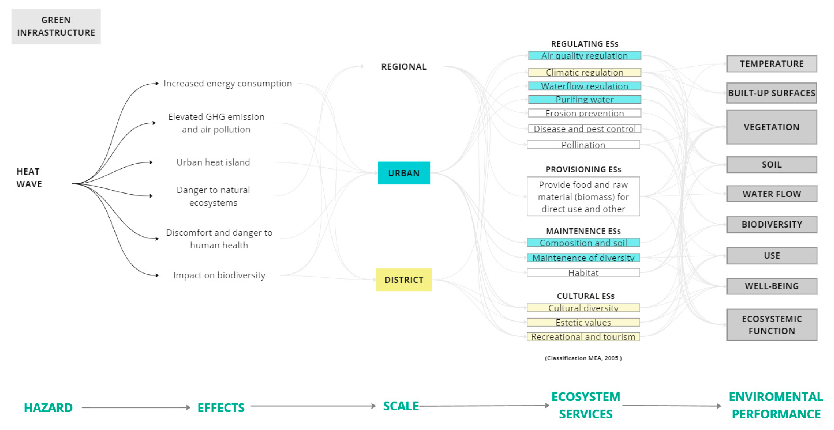
Although hubs and stepping stones are key elements for implementing UGI as climate adaptation systems, the urban-scale application of remote sensing technologies remains underexplored. To address this, in the final stage of our analysis, we focused our literature review on urban-scale methodologies and indicators, particularly considering the impacts of heat wave hazards and the urban heat island (UHI) phenomenon, which reduce the efficiency of UGIs in terms of ESs (Figure 2).
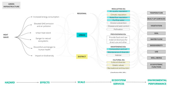
Figure 2.
Ecosystem services framework for heat waves in the multiscale approach.
We emphasize the application of remote sensing in UGI projects with a specific focus on heat wave hazards as they represent a critical emerging urban issue that necessitates intelligent, systemic, and rapid adaptation strategies, as highlighted in numerous climate studies and reports, including those by the IPCC. Heat waves increase energy consumption, elevate greenhouse gas emissions and air pollution, exacerbate the UHI effect, pose threats to natural ecosystems, cause discomfort and health risks for humans, and impact biodiversity. Furthermore, numerous studies highlight the potential of remote sensing methodologies to offer invaluable data on key variables such as surface temperature, land cover, and albedo. These data are crucial for accurately mapping and understanding the spatial distribution and intensity of heat wave hazards. By integrating remote sensing data, we can better assess and mitigate these impacts at different spatial scales—regional, urban, and district. This allows us to optimize UGI’s role in regulating ecosystem services, including air quality and climate regulation, water flow management, erosion prevention, and biodiversity conservation, as well as providing cultural and recreational benefits. Thus, remote sensing becomes a pivotal tool in enhancing the environmental performance and effectiveness of UGIs.
2.2. Steps in Method
This literature review employs a scoping review methodology, guided by the framework established by Arksey and O‘Malley [22], to address the research objectives concerning UGI and remote sensing technologies systematically. Using this approach, we adopt a funnel methodology to consider various aspects of UGI planning and design in both spatial and functional terms.
According to Arksey and O‘Malley’s framework, the methodological approach for this scoping review is structured into four distinct stages as follows:
- Identification of research objectives for search string construction.
- Identification of relevant studies to define inclusion/exclusion criteria.
- Data monitoring and sorting of information according to key questions and assumptions.
- Collection, synthesis, and reporting of results according to the research objectives.
To support this comprehensive analysis, we selected the Scopus search engine because of its extensive and reliable database, which encompasses a wide range of peer-reviewed literature across various disciplines. Scopus offers robust search functionalities and comprehensive coverage, ensuring the inclusion of high-quality sources. After conducting the initial search, we utilized VOSviewer to perform a detailed bibliometric analysis. This analysis provided insights into keyword occurrences and helped identify relevant authors, with a threshold set for keyword occurrences greater than five. The use of VOSviewer enabled the visualization of bibliometric networks, elucidating key relationships within the research field.
2.3. Step 1: Identification of Research Objectives for Search String Construction
In the first step of the method, the research objectives were identified considering three main aspects of remote sensing applications for UGI plans and projects. This involved a methodological framework consisting of a three-phase scoping process, following a funnel approach that begins with a broad overview and narrows down to specific objectives. The following process was instrumental in constructing the search strings (Figure 3):
- The first phase covered the general concept and application of remote sensing methodologies for GI planning, reflecting large-scale projects at metropolitan or regional levels. In terms of approach, this phase considered various hazards, including heat waves, but is not limited to them.
- In the second phase, the keywords of search strings were more closely aligned with the concept of remote sensing for GI design at the urban scale. This phase emphasized the key role of interoperable analytical tools for ecosystem service modeling and scenario-based simulations.
- In the final phase, we applied an additional filter to focus our results specifically on heat wave studies. This targeted approach aimed to refine the scope of the investigation and analyze and compare remote sensing methodologies for climate adaptation of GI in urban areas.
Based on this methodological framework, the research objectives were established as follows:
- (1)
- Examine the breadth, scope, and nature of research activities in the application of remote sensing technologies for GI planning.
- (2)
- Provide a clear overview of data-driven methodologies and ecosystem-based approaches that employ urban-scale satellite data for UGI design.
- (3)
- Describe a research framework for the climate-adaptive design of UGI aimed at mitigating heat waves through a data-driven process using remote sensing technologies.
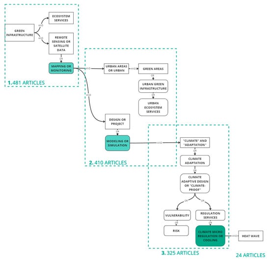
Figure 3.
The three phases of the methodological scoping process.
Figure 3.
The three phases of the methodological scoping process.

2.4. Step 2: Identification of Relevant Studies and Inclusion/Exclusion Criteria
In the second step of the method, relevant studies were identified to structure the literature analysis process. This step allowed us to determine the reference period for this study and define the inclusion and exclusion criteria (Table 1). Given the extensive consolidation of the GI topic in the scientific literature and international policy documents, it was crucial to establish a solid scientific basis to connect with remote sensing methodologies.

Table 1.
Inclusion and exclusion criteria.
A preliminary analysis compared the notion of “Green Infrastructure” with “Urban Green Infrastructure,” revealing that the former is more widely discussed in the scientific literature across various disciplines and geographical areas. Consequently, “Green Infrastructure” was adopted as the main search term, with the requirement that this term must appear in the title of the selected studies to ensure relevance to our research objectives.
The scientific interest in UGI has undergone a significant evolution in the consolidation of the concept of ecosystem services, favored by the solid scientific basis laid by the Millennium Ecosystem Assessment [5] and the emerging theories of Urban Ecology [22,23]. After identifying relevant studies [1,2,4,6,24,25], we paid particular attention to the development of the inclusion and exclusion criteria.
2.5. Step 3: Data Monitoring and Sorting of Information According to Key Questions and Assumptions
In the third step of the method, data tracking and information organization followed the three-phase scoping process framework we utilized to set the research objectives (Section 2.3). This systematic approach ensured that search strings, initially formulated based on previous studies and existing knowledge, were progressively refined to focus on and address each research objective in each phase (Figure 3).
Initially, search strings were formulated based on insights from previous studies on Green Infrastructure, ecosystem services, and remote sensing techniques for mapping and monitoring urban ecosystems. These search strings were iteratively refined by selecting relevant keywords based on their occurrence in search results, which helped to define a precise research framework aligned with the objectives.
Next, data structuring involved refining terms related to GI in urban areas and their relationship with the environmental design field. Recurring keywords at the urban project scale, as well as those related to data-driven methodologies such as modeling and simulation, were integrated to provide a comprehensive view of remote sensing applications in UGI studies.
Finally, the state of knowledge on remote sensing technologies for UGI was evaluated, particularly in the context of adaptive climate design for heat wave hazards. Keywords most relevant to describing strategies for coping with heat waves were used to ensure the research objectives were met effectively. This process allowed us to obtain several relevant results aligned with the set objectives, comparable in terms of applications and methodologies.
2.6. Step 4: Collection, Synthesis, and Reporting of Results
In the fourth step of the method, the results were systematically collected and compared for each of the 12 search strings, adhering to the three-phase scoping process outlined in Section 2.3.
Initially, a comprehensive collection of all relevant results was undertaken. A broad analysis was then conducted to compare key metrics, including the year of publication, number of publications, principal authors, significant keywords, and their occurrence more than five times in the results. Specifically, publication years were analyzed to trace the evolution of GI research, highlighting trends and shifts in focus, particularly concerning ecosystem service mapping and remote sensing methodologies.
According to our research objectives, the results were more carefully collected by applying filters to ensure significant outcomes for the subsequent phase. For example, we identified the top ten keywords for each string based on their occurrence, prioritized authors by publication frequency and citation impact, and identified the most prolific research centers.
After each of the three main phases, the most relevant results were extracted and compared to yield detailed insights into the methodologies and indicators utilized within the studies, as well as specific information on the ecosystem services mapped. This process allowed us to obtain several relevant results aligned with the set objectives, comparable in terms of applications and methodologies. This systematic process ensured a thorough understanding of how remote sensing technologies are applied in UGI planning, particularly in the context of mitigating heat wave hazards. Although specifically mentioned for heat waves, this approach is repeatable for all types of hazards.
3. Results
3.1. Overview of Research Activities
According to the research objectives highlighted in step one, the results were systematically organized and analyzed to address the scope of this research, transitioning from a general overview of the findings to a more specific focus on methodologies (Figure 3 and Figure 4). In the first part of the collection of the results, we considered all three phases to examine the breadth, scope, and nature of research activities in the field of applying remote sensing technologies for UGI planning, providing a temporal and thematic overview across all relevant research studies. This analysis aimed to address the first research objective (1).
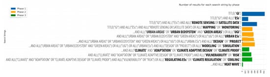
Figure 4.
Results of the scoping review process across three phases.
In the first phase of analysis (Figure 3), the scoping process identified 481 relevant articles. By applying more stringent inclusion criteria in the second phase, this selection was refined to 410 articles. The final phase further narrowed the results to 325 articles, focusing on those that most closely matched this study’s objectives. From these, only those with the most relevant key metrics were selected for detailed analysis, resulting in 24 highly relevant articles being thoroughly examined in terms of methodologies and application cases (Appendix B, Appendix C, Appendix D).
The first phase of the scoping process examined the general concept and application of remote sensing methodologies in GI planning, reflecting large-scale projects at metropolitan and regional levels (Appendix A). The results are well-aligned with the concept of ecosystem services. However, significant interest in remote sensing only grew in 2010, showing an increasing use for mapping and monitoring UGI through spatial analyses in GIS (Figure 4 and Figure 5).
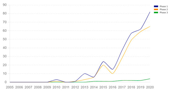
Figure 5.
Temporal evolution of the results for each string by phase.
The analysis showed a generally increasing trend in research activities, with noticeable peaks in 2012, 2014, 2016, and 2019, but a decline in 2021 (Figure 5).
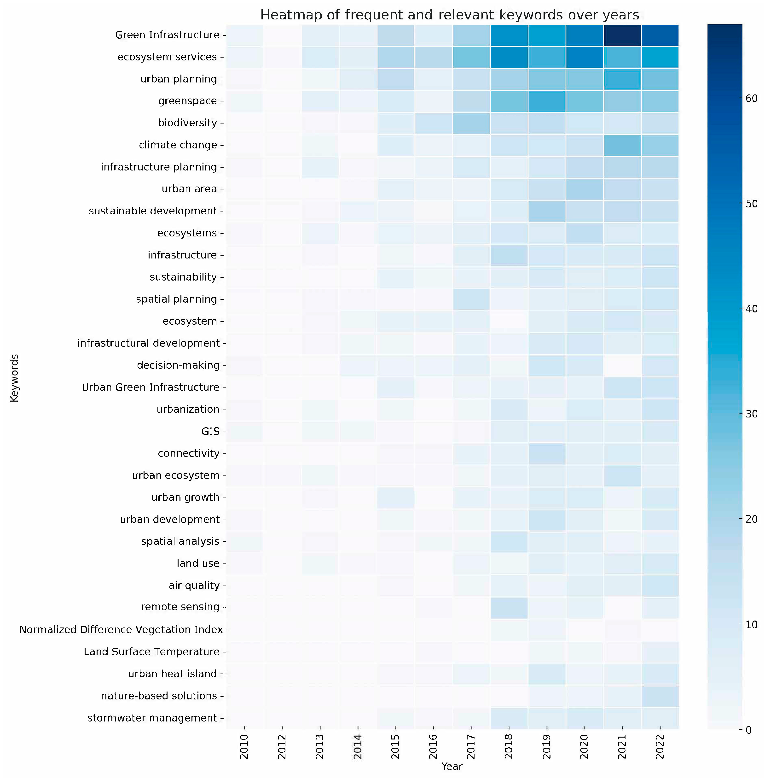
In the second phase, the keywords of search strings were more closely aligned with the concept of remote sensing for GI design at the urban scale. This phase emphasized the key role of interoperable analytical tools for ecosystem service modeling and scenario-based simulation. Furthermore, since 2013, there has been a greater correspondence in results related to climate change adaptation studies, as well as those addressing urban heat island effects (Figure 6 and Figure 7).
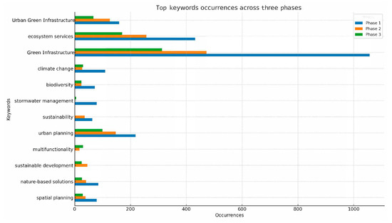
Figure 6.
Top keyword occurrences across the three phases.
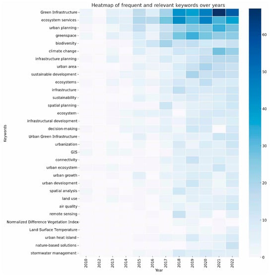
Figure 7.
Heatmap of top keywords occurrences over time.
In the final phase of the keyword research process, it emerged that focusing on the keyword “heat wave” led to highly relevant results for remote sensing methodologies applied to UGI, including the occurrence of some multispectral indices widely used in the literature to analyze the response of UGI to heat wave effects, such as NDVI (Normalized Difference Vegetation Index) and LST (Land Surface Temperature). Moreover, since 2018, the results have significantly increased, indicating a high responsiveness of remote sensing technologies for climate adaptation during heat wave phenomena (Figure 7).
3.2. Applications and Methodologies
At the end of the three phases, the 24 articles most aligned with the research objectives were selected based on key metrics for a detailed analysis of the proposed methodologies and specific approaches used to map ecosystem services (Appendix B, Appendix C, Appendix D). These results were further analyzed to address the second and third objectives including the following:
(2) Provide a clear overview of the data-driven methodologies and ecosystem-based approaches that employ urban-scale satellite data for UGI design.
(3) Describe a research framework for the climate-adaptive design of UGI aimed at mitigating heat waves through a data-driven process using remote sensing technologies.
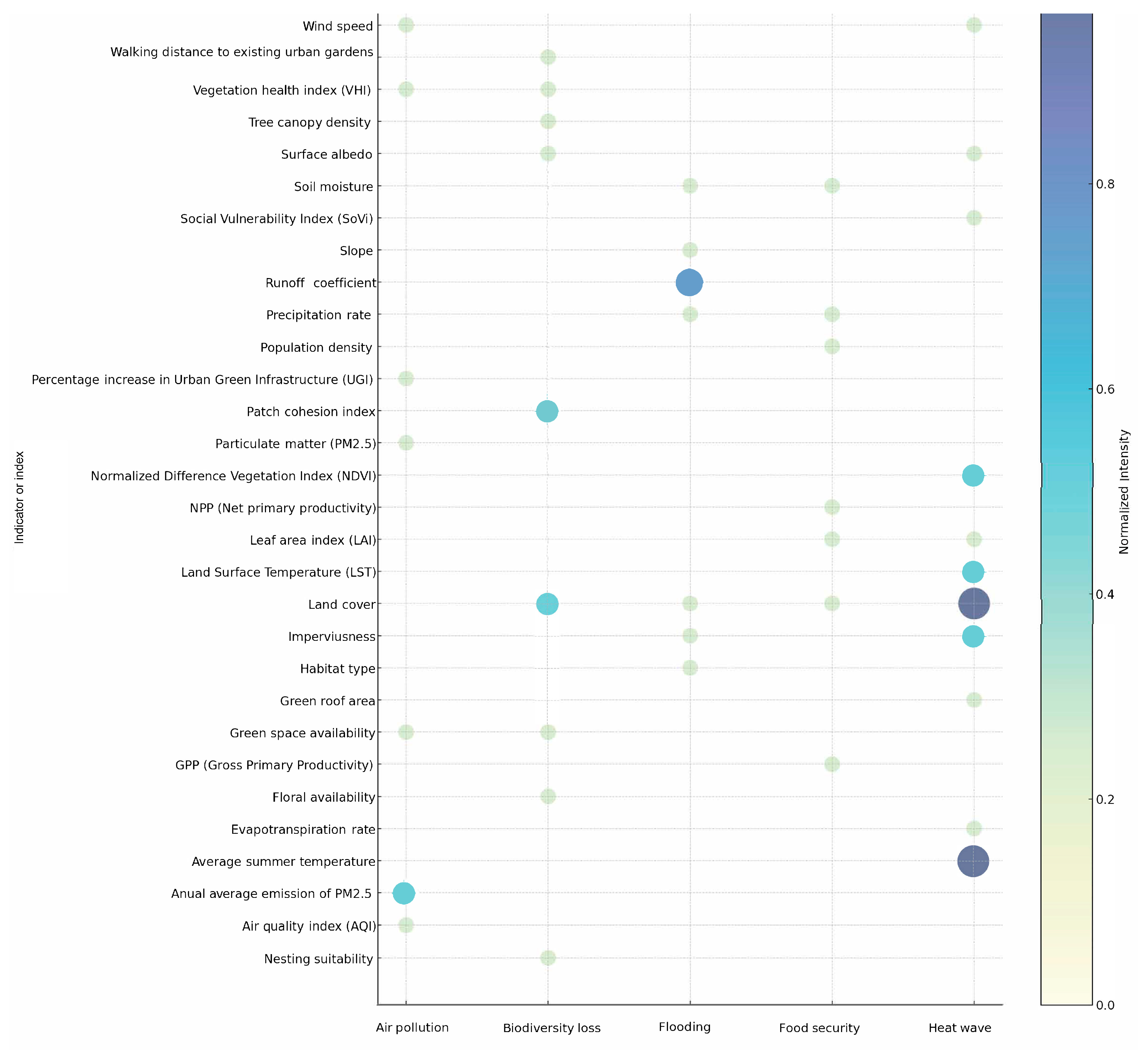
The aim was to provide an overview and compare the methodologies in terms of the use of indicators related to the specific hazard (Figure 8). Notably, from the general overview process, none of the identified studies span multiple scales; rather, all studies focus on individual scales of application. The scales considered include regional, urban, and local (district). We focus on analyzing the results for each scale independently, as none of the studies employed multi-scale approaches.
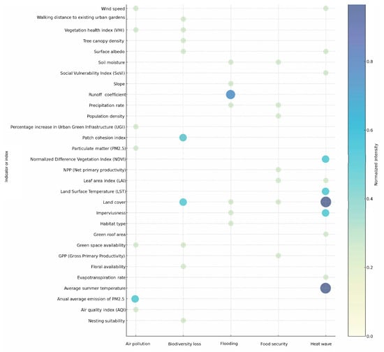
Figure 8.
Bubble chart of key indicators recorded in the third phase of analysis.
3.2.1. Regional Scale Applications
In the first phase, which focused on applications at the regional and metropolitan scale, the results indicate that remote sensed technologies are predominantly used for spatial planning and ecosystem protection and management (Appendix B). The mapping objects at this scale include the supply of regulating and maintaining ecosystem services, biodiversity, and the relationships between UGIs and the health and well-being of the population [26,27,28,29,30,31]. Specifically, methodologies are employed to map phenomena such as habitat fragmentation, soil erosion, air pollution, ad coastal vulnerability. At this scale, open-source satellite data with global coverage are used to map the state of natural resources and specific land transformation phenomena. The most common analytical methodologies at this level are those that integrate land cover and land use data with local data for the application of ecosystem-based dynamic models. A recurring approach in the results is the use of InVEST (Integrated Valuation of Ecosystem Services and Tradeoffs), a tool developed by the Natural Capital Project [26]. InVEST is used to assess how different management choices affect ecosystem services, such as carbon sequestration, water purification, and coastal protection. Among the most important indicators identified in these studies are the rate of deposition of air pollutants on vegetation, erosion control, water infiltration into the soil, coastal protection capabilities, and carbon content in above-ground biomass. Land cover and land use, habitat type, plant and invertebrate diversity, and Shannon’s Index (SHDI) are frequently used to assess biodiversity and landscape health. Indicators such as slope, sediment composition, sea level changes, and storm flood potential are critical for understanding ecosystem vulnerability and resilience.
3.2.2. Urban Scale Applications
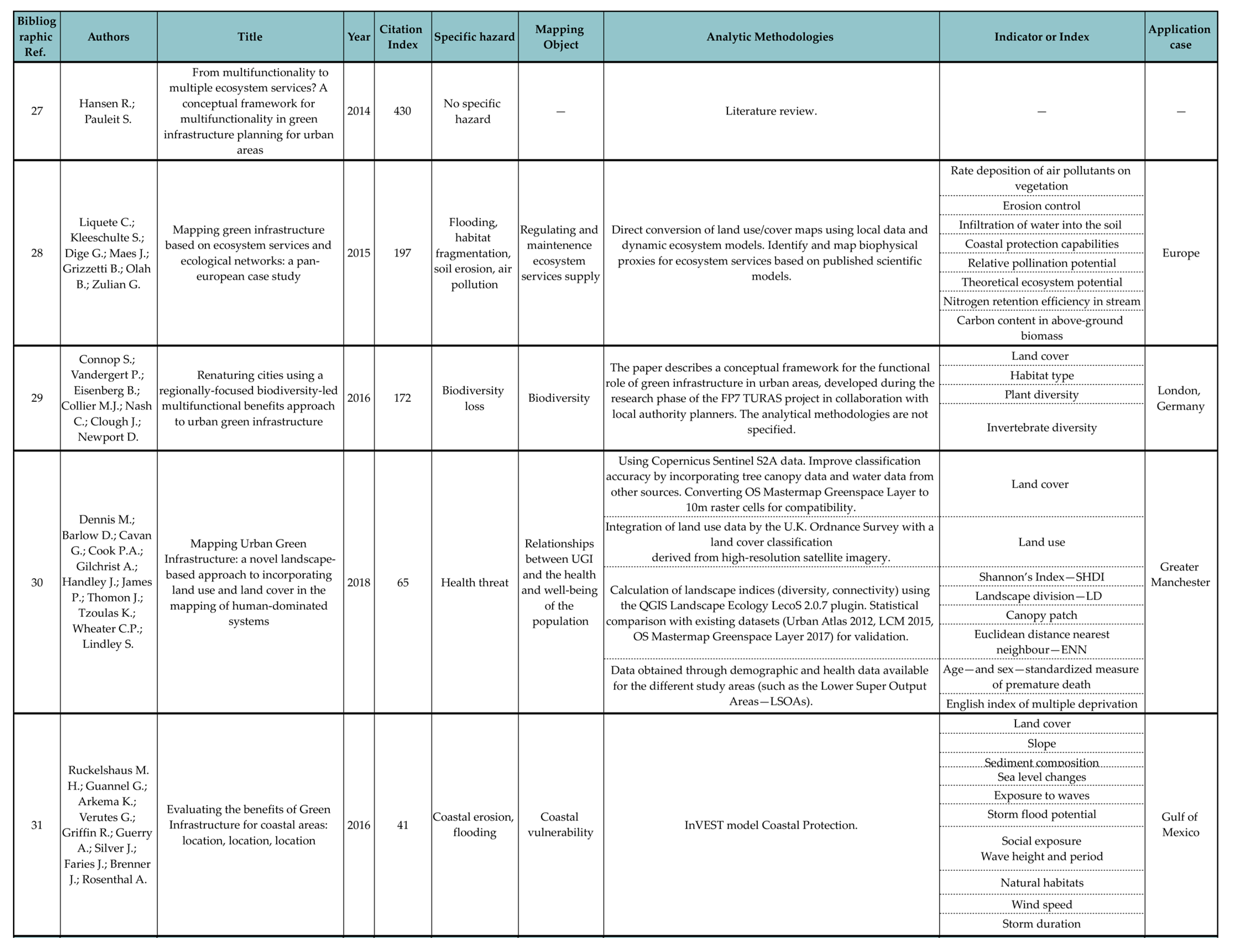
The results from the second phase pertain to the application of remote sensing methodologies at an urban scale for UGI design (Appendix C). The primary hazards include air pollution, flooding, and heat waves. The mapping objects at this scale are focused on co-benefit provision, climate regulating services, and opportunities for nature-based recreation [32,33,34,35,36]. These results show that mapping and monitoring methodologies based on remote sensing data at this scale are often integrated with modeling and simulation activities, especially to quantify and compare benefits and co-benefits in different design scenarios. Specific studies on air pollution demonstrate how UGI can sequester pollutants and cool urban areas, thereby improving overall urban climate regulation. Tools such as ENVI-met for three-dimensional and thermodynamic microclimate modeling, and I-Tree Eco for evaluating urban regulatory ecosystem services, have been widely used. The most used methodologies include spatial analysis based on green area and population data, on-field surveys with GPS, and air quality monitoring over extended periods. The results also indicate the use of detailed satellite data overlapped with social, demographic, and economic data to ensure a benefit-based approach. For example, studies have calculated recreational potential using the ESTIMAP-recreation model, which considers factors such as the presence of water, protected natural areas, and the degree of naturalness of the environment. The model combines recreational potential (RP) with proximity information, such as distance from roads and urban areas, to provide a comprehensive assessment. Among the most important indicators identified in these studies are carbon sequestration, daily mean temperature, and the number of pollutants captured by vegetation. These indicators are crucial for understanding the environmental benefits of UGI. Social indicators such as accessibility to public green spaces and the number of people being physically active highlight the human benefits provided by urban green areas. Additionally, indicators like the Green Area Ratio (GAR) and total green area per inhabitant help measure the extent and accessibility of green spaces in urban environments.
3.2.3. Application for Heat Wave Adaptation at the District Level
The results of the last phase, which focuses on remote sensing technologies for the climate-adaptive design of UGI, are centered on mapping the response to heat wave hazards (Appendix D). The mapping objects in this phase are more specific and include the assessment of heat exposure areas, vulnerability of different demographic groups, behavioral patterns influencing heat exposure, cooling benefits of vegetation, urban heat island intensity, social vulnerability, and access to green spaces [37,38,39,40,41,42,43,44,45,46,47,48,49,50,51]. Additionally, the mapping objects extend to microclimatic regulation by urban vegetation, the impacts of UGI on nighttime temperature variations, and overall well-being related to green areas. For instance, the studies examine flood control and urban cooling benefits provided by green roofs and other UGI components. The methodologies most used involve high-resolution satellite data to capture detailed site-specific information. Public and open datasets such as Sentinel-2 from Copernicus and Landsat are typically used, but for more specific applications addressing heat wave hotspots, additional commercial data and environmental sensors, including those on drones, are integrated. These sensors capture detailed environmental variations and provide precise measurements of parameters such as air temperature and humidity.
The data collected from these remote sensing technologies are often integrated with detailed demographic and census information, including population density, age distribution, health status, and hospital admissions. This integration allows for the establishment of statistically significant correlations between heat wave phenomena and the most vulnerable demographic groups.
In the context of heat wave adaptation, the most relevant indicators and indices identified in the studies include air temperature, which provides a direct measure of the thermal environment, and Land Surface Temperature (LST), which gives insights into surface heat variations. The Normalized Differential Vegetation Index (NDVI) is used to measure vegetation reflectance, distinguishing between vegetated and non-vegetated surfaces and highlighting the cooling effects of green areas. Social vulnerability indices, such as the Social Vulnerability Index (SoVi) and the Index of Relative Socio-Economic Disadvantage (IRSD), help identify populations most at risk. Additional indicators like mean and maximum air temperatures, relative humidity at 2 m, and cloud cover are essential for understanding microclimatic conditions. Urban design elements, including street width, the height-to-width ratio, and green roof area, are also considered for their impact on urban heat island (UHI) effects and overall cooling. Furthermore, social and economic factors such as the elderly population density, building energy performance, and neighborhood walkability are important for evaluating the broader implications of heat wave mitigation strategies. These indicators provide a comprehensive framework for assessing urban heat stress and the effectiveness of UGI in mitigating high temperatures, enhancing the resilience of urban environments to heat wave hazards.
4. Discussion
This scoping literature review provides critical insights into the application of remote sensing technologies for UGI planning and design, highlighting the necessity of a multiscale, integrative approach for developing proper and effective strategies. The findings align with the initial objectives and assumptions, offering a comprehensive perspective on the evolving studies. The discussion is structured to address the research questions progressively, based on the following funnel approach:
- A temporal analysis of the evolution in the field of research in relation to major guiding documents and technological advancements.
- Methodological overview at the regional scale.
- Methodological overview at the urban scale.
- Methodological overview of heat wave applications.
- Focus on emerging indicators of heat waves.
4.1. Temporal Analysis
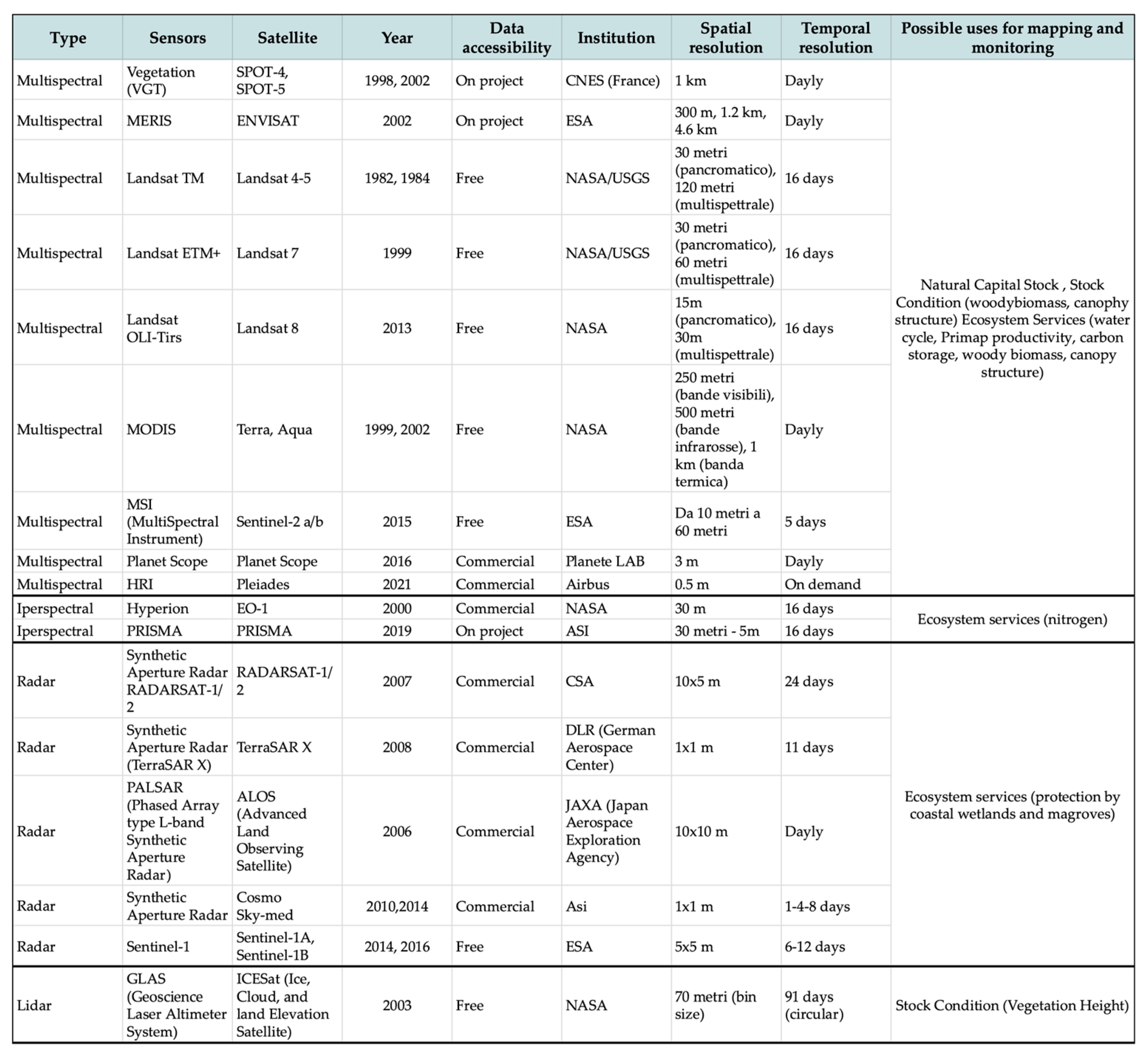
We analyzed the trends in the three phases by comparing the most recurring keywords and then specifically examined the occurrence of keywords over the years across all results to identify the research fields that are most consolidated in the scientific literature (Figure 5 and Figure 6). The results show that the set temporal range, along with the inclusion and exclusion criteria and the field of analysis, is appropriate. The temporal analysis (Figure 9 and Figure 10) reveals distinct peaks in research activity that align with the release of significant policy documents, agreements, and advancements in remote sensing technology. This suggests a growing recognition of the importance of UGI mapping and monitoring for climate change mitigation and adaptation efforts, reflecting the strategic role of these analytical methodologies. Following the 2008 UNFCCC (Compendium on Methods and Tools to Evaluate Impacts of, and Vulnerability and Adaptation to, Climate Change) [52] and the Copenhagen Accord of 2009, there was an initial rise in interest, reflecting an increased interest in analytical methodologies for climate adaptation strategies. The 2010 TEEB (The Economics of Ecosystems and Biodiversity) [53] report further amplified this trend by highlighting the economic value of ecosystems. A marked surge in research activity post-2013 aligns with the EU’s MAES (Mapping and Assessment of Ecosystems and their Services) strategy [54], which emphasizes the integration of ecosystem services into urban planning through comprehensive ecosystem mapping and assessment. The Paris Agreement in 2015, the launch of the Sustainable Development Goals, and the deployment of Sentinel 2A/2B satellites led to another significant peak, underscoring global commitments to climate adaptation and the enhanced capabilities of new remote sensing tools. Further intensification in 2018, driven by the IPCC’s report on Global Warming of 1.5 °C and the release of Landsat 8 data, underscores the urgent need for effective and suitable adaptive measures. The European Green Deal in 2019 [54] and the EU Biodiversity Strategy in 2020 [55] sustained high research interest, reinforcing a strategic focus on sustainable urban development and ecosystem restoration.
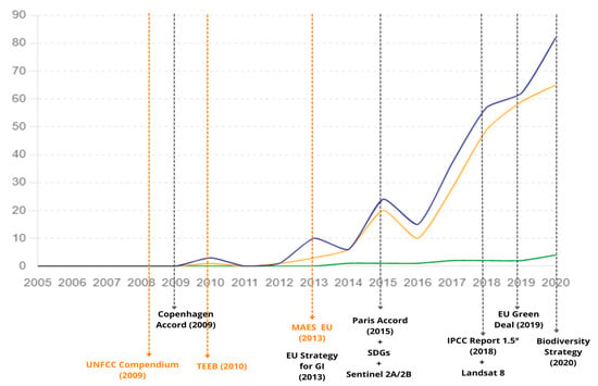
Figure 9.
Temporal overview across the three phases of investigation.
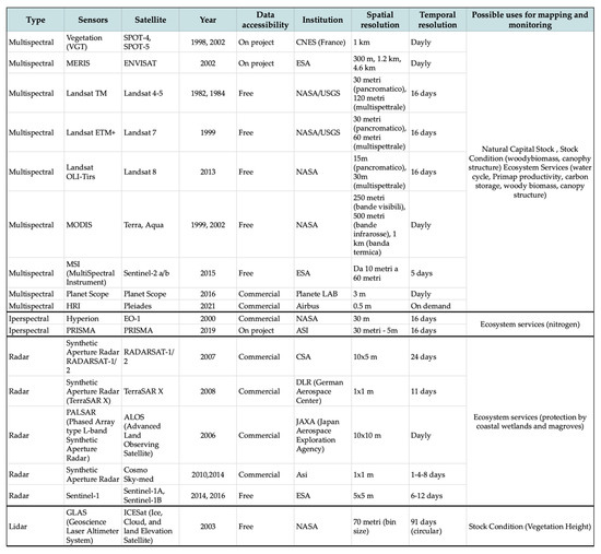
Figure 10.
Overview of remote sensing data types and purposes.
These trends indicate that key international policies and technological advancements have critically shaped the research framework, driving global efforts to integrate data-driven methodologies into climate adaptation strategies.
The keyword occurrence temporal graph (Figure 7) reveals that widely established concepts in the scientific literature, such as GI, ecosystem services, and spatial planning, appear frequently, showing steep gradients. They represent umbrella concepts that encompass the entire body of work, acting as red threads running through the scientific literature across all considered disciplines. In contrast, more specific keywords related to methodologies like remote sensing appear less frequently, indicating emerging research areas. This demonstrates the multisectoral nature and the ability to capture evolutionary processes closely tied to technological advancements, highlighting their strong dependence.
4.2. Methodological Overview of Regional-Scale Applications
The breadth and depth of research activity in remote sensing methodologies for GI planning reflect a substantial and growing body of work. The extensive use of remote sensing for spatial planning and ecosystem mapping and monitoring at regional and metropolitan scales demonstrates the versatility and scalability of these technologies. Most of the studies emphasize the importance of integrating land cover and land use data with local information to model ecosystem dynamics effectively, underscoring the potential of remote sensing to capture large-scale environmental patterns and inform regional planning decisions. Applications at this scale often do not require highly detailed satellite data and thus frequently utilize open-source products such as Sentinel-2 or Landsat 8. Moreover, significant attention is given to GI as ecological networks, with a focus on habitat restoration and conservation and phenomena such as landscape fragmentation and other spatial modification. This reflects the inherently sectoral nature of these applications, which tend to analyze specific phenomena rather than adopting a holistic view of environmental complexities, thus prioritizing specialized approaches over integrated environmental assessment.
4.3. Methodological Overview of Urban-Scale Applications
At the urban scale, theoretical and experimental methodologies reveal a growing trend toward tool interoperability. This includes tools for modeling design scenarios and simulating alternatives to assess potential benefits. This multiscale and multidisciplinary approach, reflecting the complexity of urban systems, goes beyond ecosystem mapping and monitoring strategies and supports detailed design processes. For example, studies where remotely sensed satellite data, particularly land cover, are used to feed ENVI-met models for quantifying environmental performance and I-Tree for evaluating the ecosystem services of urban greenery. This approach not only quantifies the benefits of UGIs in terms of regulation ecosystem services, such as air quality regulation, climate regulation, erosion regulation, and pollination, but also considers cultural ecosystem services, which are fundamental to the effectiveness of projects in an urban complex environment.
Such integration provides comprehensive support to UGI design and decision-making processes, addressing ecological and human factors to maximize ecological, social, and cultural benefits. While this integrated approach offers a robust framework for UGI assessment and the development of design strategies, several challenges and limitations must be acknowledged. The accuracy and resolution of remote sensing data can vary based on the technology and methodologies used, potentially impacting the reliability of results. Additionally, integrating diverse data sources requires substantial expertise in data management and analysis.
4.4. Methodological Overview for Heat Wave Adaptation
An original contribution of this study is the comparison of remote sensing methodologies for the climate-adaptive design of UGI, specifically aimed at mitigating heat waves (Appendix D). This document details recurring indicators and their respective methodologies for digitally modeling either the effects of heat waves on different population groups or the benefits, in terms of ecosystem services, achievable through the implementation of specific Green Infrastructure components, such as green roofs.
The results underscore the extensive use of high-resolution satellite data, which not only provide continuous land cover information but also crucial air and surface temperature data essential for mapping the urban heat island (UHI) phenomenon.
However, for several applications, the integration of commercial data from drone sensors and on-site environmental sensors is essential to provide detailed insights into microclimatic local conditions and heat wave hotspots. Our findings also show a significant trend toward integrating demographic and social data, enabling the identification of vulnerable groups and supporting more precise and equitable adaptation strategies. This approach reflects the initial assumption that effective UGI must adapt to both natural and anthropogenic systems, thereby enhancing urban resilience through tailored UGI strategies while ensuring they meet stakeholders’ needs.
4.5. Emergent Indicator Categories
A critical component of this review is the investigation and categorization of indicators, which are essential for understanding mapping objectives and methodologies. The recorded set of indicators, representing the necessary information for the climate adaptation project for heat waves, highlighted the increasingly recognized trend in the literature to consider multiple specific hazards in project decisions (Figure 11). Therefore, we categorized the indicators to obtain further specification and ensure a comprehensive analysis, grouping them into several key categories including the following: land cover indicators, environmental performance indicators, ecosystem structure indicators, ecosystem condition indicators, social and wellbeing indicators, and land use indicators. This structured framework addresses the critical aspects of climate adaptation, ensuring a holistic and effective approach to managing urban heat waves and enhancing urban resilience.

Figure 11.
Comparison and classification of key indicators recorded in the third phase of the analysis.
Land cover indicators, such as NDVI, provide insights into vegetation health and connectivity, which are crucial for managing urban heat waves and evaluating green areas’ effectiveness in cooling and temperature reduction. Ecosystem structure indicators, like habitat connectivity and landscape fragmentation, help identify critical areas for ecological interventions that promote biodiversity and resilience. Land use indicators inform strategic planning by classifying urban land into residential, commercial, and industrial areas, facilitating targeted UGI benefits. Social and well-being indicators, including population density and socio-economic distribution, can be integrated with environmental data to identify heat wave-vulnerable areas, ensuring policies meet local community needs. Ecosystem condition indicators, such as vegetation health and soil pollution, are used to monitor the overall state of urban ecosystems, guiding restoration and management strategies. Lastly, environmental indicators, including surface temperature and air quality, are used to assess UGIs’ impacts on the urban microclimate, highlighting their role in reducing temperatures and improving air quality for healthier urban environments.
5. Conclusions
Urban Green Infrastructures have emerged as critical components in climate-adaptive urban planning and design, particularly for their role in mitigating the effects of global warming in relatively short timeframes. The effectiveness of UGIs is based on a thorough understanding of urban ecosystem dynamics, facilitated by the strategic mapping and monitoring of ecosystem services across various scales.
The integration of remote sensing data, spanning from regional to local levels, enhances our comprehension of the interplay between urban and natural environments. Advanced analytical tools play a pivotal role in this integration, enabling precise quantification of environmental performance within urban settings. This, in turn, supports informed decision-making in the development and implementation of UGIs. By combining the mapping and monitoring of ESs with modeling tools, these data-driven approaches optimize the ecological and socio-economic benefits of UGIs, thereby bolstering urban and climate resilience. Such evidence-based planning not only enhances ecological efficiency but also fosters greater community acceptance, leading to improved management of ecosystem services over time.
Despite their growing importance, the implementation of remote sensing methodologies for UGI planning and design is often complex, as it relies on non-open-source data or software, making interoperability among mapping, monitoring, modeling, and simulation tools difficult. Additionally, the availability and accessibility of data are not uniform geographically, as not all countries have adopted the same data implementation policies within dedicated platforms. Reliable and cyclically updated data are crucial for making accurate predictions regarding the impacts of specific greening interventions in urban areas. Furthermore, collaboration among public administrations and stakeholders is essential for maintaining these datasets and fostering inclusive urban planning processes. Such coordinated efforts ensure that UGIs address specific urban requirements effectively, thereby enhancing the overall performance and resilience of urban green networks. Future developments could involve the use of machine learning systems to optimize the acquisition and utilization of satellite data. Projects like AI4Copernicus aim to connect Artificial Intelligence (AI) with Earth Observation (EO), simplifying the acquisition of large quantities of EO data and promoting access to educational materials and expertise.
Author Contributions
Methodology, software, and investigation, M.D.P.; original writing, M.D.P.; conceptualization, validation, and editing M.R., M.F.L. and M.D.P. All authors have read and agreed to the published version of the manuscript.
Funding
This research was funded by the project KNOWING (www.knowing-climate.eu, accessed on 25 February 2024) “Framework for defining Climate Mitigation Pathways based on Understanding and integrated Assessment of Climate Impacts, Adaptation Strategies and Societal Transformation”, which received funding from the European Union under the Horizon Europe program (GA 1011056841).
Institutional Review Board Statement
Not applicable.
Informed Consent Statement
Informed consent was obtained from all subjects involved in this study.
Conflicts of Interest
The authors declare no conflicts of interest.
Appendix A

Figure A1.
Research string used in phase 1.
Figure A1.
Research string used in phase 1.

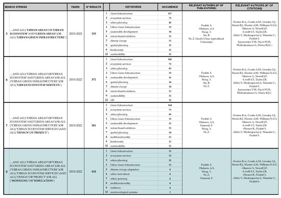
Figure A2.
Research string used in phase 2.
Figure A2.
Research string used in phase 2.
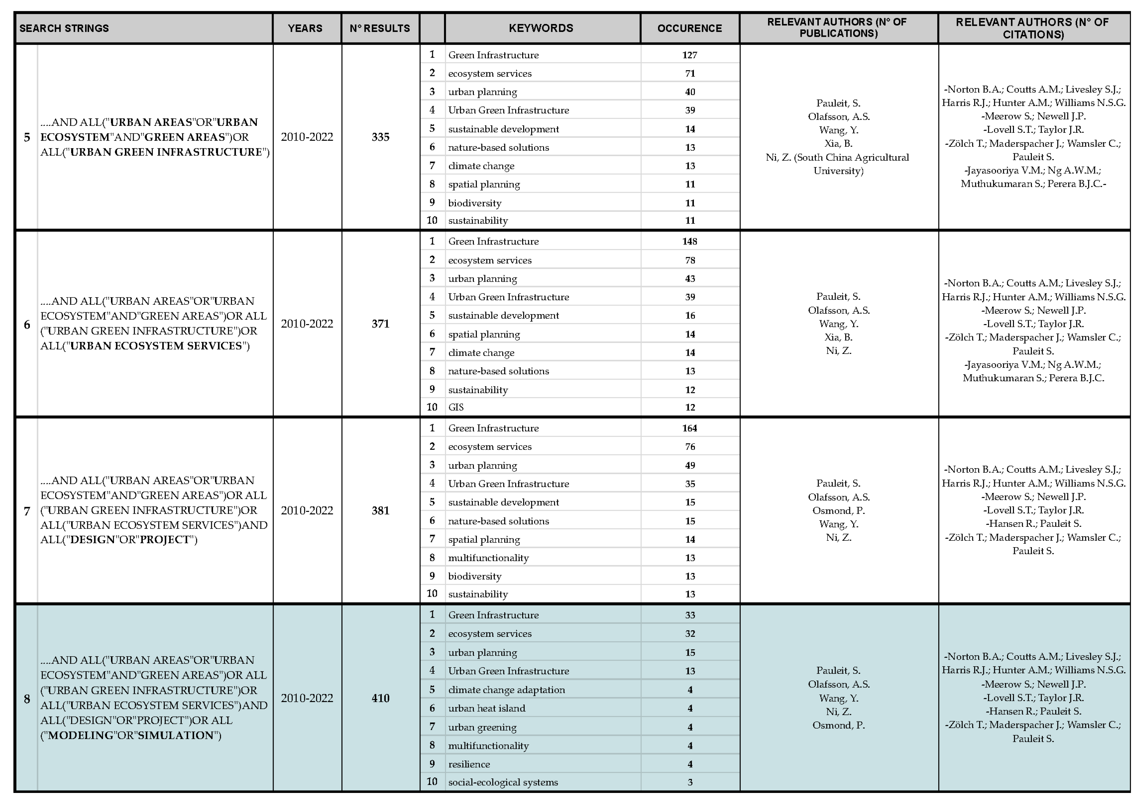

Figure A3.
Research string used in phase 3.
Figure A3.
Research string used in phase 3.
Appendix B
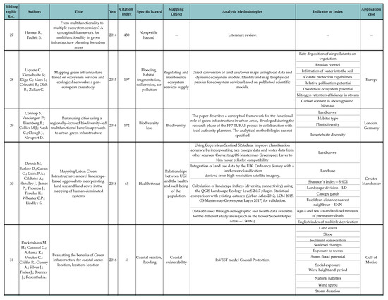
Figure A4.
Results of applying of remote sensing technologies for mapping and monitoring GI. The bibliographic references are listed in the first column and can also be found in the bibliography.
Figure A4.
Results of applying of remote sensing technologies for mapping and monitoring GI. The bibliographic references are listed in the first column and can also be found in the bibliography.
Appendix C

Figure A5.
Results of applying remote sensing technologies for mapping, modeling, and simulation of UGI at the urban scale. The bibliographic references are listed in the first column and can also be found in the bibliography.
Figure A5.
Results of applying remote sensing technologies for mapping, modeling, and simulation of UGI at the urban scale. The bibliographic references are listed in the first column and can also be found in the bibliography.
Appendix D

Figure A6.
Results of the application of remote sensing technologies for climate adaptation project for the heat wave. The bibliographic references are listed in the first column and can also be found in the bibliography.
Figure A6.
Results of the application of remote sensing technologies for climate adaptation project for the heat wave. The bibliographic references are listed in the first column and can also be found in the bibliography.

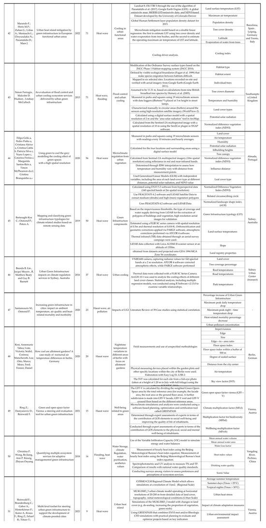
Figure A7.
Results of applying remote sensing technologies for climate adaptation projects to address heat waves. The bibliographic references are listed in the first column and can also be found in the bibliography.
Figure A7.
Results of applying remote sensing technologies for climate adaptation projects to address heat waves. The bibliographic references are listed in the first column and can also be found in the bibliography.

References
- European Commission. Communication from the Commission to the European Parliament, the Council, the European Economic and Social Committee and the Committee of the Regions, Green Infrastructure (GI)—Enhancing Europe’s Natural Capital; COM/2013/0249 Final; European Commission: Brussels, Belgium, 2013. [Google Scholar]
- Benedict, M.; McMahon, E.T. Green infrastructure: Smart conservation for the 21st century. Renew. Resour. J. 2002, 20, 12–17. [Google Scholar]
- Sandström, S. Green infrastructure planning in urban Sweden. Plan. Pract. Res. 2002, 17, 373–385. [Google Scholar] [CrossRef]
- Cook, E.A. Landscape structure indices for assessing urban ecological networks. Landsc. Urban Plan. 2002, 58, 269–280. [Google Scholar] [CrossRef]
- Millennium Ecosystem Assessment. Ecosystems and Human Well-Being: Wetlands and Water Synthesis; Millennium Ecosystem Assessment: Washington, DC, USA, 2005. [Google Scholar]
- Gill, S.E.; Handley, J.F.; Ennos, A.R.; Pauleit, S. Adapting cities for climate change: The role of the green infrastructure. Built Environ. 2007, 33, 115–133. [Google Scholar] [CrossRef]
- Rigillo, M. Infrastrutture verdi e servizi eco-sistemici in area urbana: Prospettive di ricerca per la progettazione ambientale. Techne 2016, 11, 59–65. [Google Scholar]
- D’Ambrosio, V.; Di Martino, F.; Rigillo, M. Digital geocomputational technologies for the metaproject of urban green infrastructures. AGATHÓN Int. J. Archit. Art Des. 2022, 11, 162–171. [Google Scholar]
- Potschin, M.B.; Haines-Young, R.H. Ecosystem services: Exploring a geographical perspective. Prog. Phys. Geogr. 2011, 35, 575–594. [Google Scholar] [CrossRef]
- Ochoa, V.; Urbina-Cardona, N. Tools for spatially modeling ecosystem services: Publication trends, conceptual reflections and future challenges. Ecosyst. Serv. 2017, 26, 155–169. [Google Scholar] [CrossRef]
- Di Cesare, E.A.; Floris, R.; Cocco, C.; Campagna, M. Linking knowledge to action with geodesign. In Smart Planning: Sustainability and Mobility in the Age of Change; Springer: Cham, Switzerland, 2018; pp. 179–198. [Google Scholar]
- Leone, M. Adattamento climatico e gestione del rischio. In Adattarsi al Clima che Cambia, Innovare la Conoscenza per il Progetto Ambientale; Losasso, M., Lucarelli, M.T., Rigillo, M., Valente, R., Eds.; Maggioli Editore: Rimini, Italy, 2020. [Google Scholar]
- Furberg, D.; Ban, Y.; Mörtberg, U. Monitoring urban green infrastructure changes and impact on habitat connectivity using high-resolution satellite data. Remote Sens. 2020, 12, 3072. [Google Scholar] [CrossRef]
- Chauvenet, A.L.; Reise, J.; Kümpel, N.F.; Pettorelli, N. Satellite-Based Remote Sensing for Measuring the Earth’s Natural Capital and Ecosystem Services. 2015. Available online: https://www.researchgate.net/publication/313143864_Satellite-based_remote_sensing_for_measuring_the_earth's_natural_capital_and_ecosystem_services (accessed on 15 January 2024).
- Venhari, A.A.; Tenpierik, M.; Mahdizadeh Hakak, A. Heat mitigation by greening the cities, a review study. Environ. Earth Ecol. 2017, 1, 5–32. [Google Scholar] [CrossRef]
- Firehock, K.E.; Walker, R.A. Green Infrastructure: Map and Plan the Natural World with GIS; Esri Press: Redlands, CA, USA, 2019. [Google Scholar]
- Core Writing Team; Lee, H.; Romero, J. (Eds.) Climate Change 2023: Synthesis Report, Summary for Policymakers. Contribution of Working Groups I, II and III to the Sixth Assessment Report of the Intergovernmental Panel on Climate Change; IPCC: Geneva, Switzerland, 2023. [Google Scholar]
- European Commission EEA. Climate-ADAPT Strategy 2022–2024: Sharing Knowledge for a Climate-Resilient Europe; European Commission EEA: Brussels, Belgium, 2022. [Google Scholar]
- Forman, R.T. Land Mosaics: The Ecology of Landscapes and Regions; Cambridge University Press: Cambridge, UK, 1995. [Google Scholar]
- Kerr, J.T.; Ostrovsky, M. From space to species: Ecological applications for remote sensing. Trends Ecol. Evol. 2003, 18, 299–305. [Google Scholar] [CrossRef]
- Qian, Y.; Zhou, W.; Yu, W.; Pickett, S.T. Quantifying spatiotemporal pattern of urban greenspace: New insights from high-resolution data. Landsc. Ecol. 2015, 30, 1165–1173. [Google Scholar] [CrossRef]
- Colding, J. The role of ecosystem services in contemporary urban planning. In Urban Ecology: Patterns, Processes, and Applications; Niemelä, J., Breuste, J.H., Guntenspergen, G., McIntyre, N.E., Elmqvist, T., James, P., Eds.; OUP: Oxford, UK, 2011; pp. 228–237. [Google Scholar]
- Alberti, M. Measuring urban sustainability. Environ. Impact Assess. Rev. 1996, 16, 381–424. [Google Scholar] [CrossRef]
- European Commission. Forging a Climate-Resilient Europe—The New EU Strategy on Adaptation to Climate Change; COM/2021/82 Final; European Commission: Brussels, Belgium, 2021. [Google Scholar]
- European Environmental Agency. Spatial Analysis of Green Infrastructure in Europe; EEA Technical Report No 2; European Environmental Agency: Copenhagen, Denmark, 2014. [Google Scholar]
- Salata, S.; Garnero, G.; Barbieri, C.A.; Giaimo, C. The integration of ecosystem services in planning: An evaluation of the nutrient retention model using InVEST software. Land 2017, 6, 48. [Google Scholar] [CrossRef]
- Hansen, R.; Pauleit, S. From multifunctionality to multiple ecosystem services? A conceptual framework for multifunctionality in green infrastructure planning for urban areas. Ambio 2014, 43, 516–529. [Google Scholar] [CrossRef] [PubMed]
- Liquete, C.; Kleeschulte, S.; Dige, G.; Maes, J.; Grizzetti, B.; Olah, B.; Zulian, G. Mapping green infrastructure based on ecosystem services and ecological networks: A Pan-European case study. Environ. Sci. Policy 2015, 54, 268–280. [Google Scholar] [CrossRef]
- Connop, S.; Vandergert, P.; Eisenberg, B.; Collier, M.J.; Nash, C.; Clough, J.; Newport, D. Renaturing cities using a regionally-focused biodiversity-led multifunctional benefits approach to urban green infrastructure. Environ. Sci. Policy 2016, 62, 99–111. [Google Scholar] [CrossRef]
- Dennis, M.; Barlow, D.; Cavan, G.; Cook, P.A.; Gilchrist, A.; Handley, J.; James, P.; Thompson, J.; Tzoulas, K.; Wheater, C.P.; et al. Mapping urban green infrastructure: A novel landscape-based approach to incorporating land use and land cover in the mapping of human-dominated systems. Land 2018, 7, 17. [Google Scholar] [CrossRef]
- Ruckelshaus, M.H.; Guannel, G.; Arkema, K.; Verutes, G.; Griffin, R.; Guerry, A.; Silver, J.; Faries, J.; Brenner, J.; Rosenthal, A. Evaluating the benefits of green infrastructure for coastal areas: Location, location, location. Coast. Manag. 2016, 44, 504–516. [Google Scholar] [CrossRef]
- Raymond, C.M.; Frantzeskaki, N.; Kabisch, N.; Berry, P.; Breil, M.; Nita, M.R.; Geneletti, D.; Calfapietra, C. A framework for assessing and implementing the co-benefits of nature-based solutions in urban areas. Environ. Sci. Policy 2017, 77, 15–24. [Google Scholar] [CrossRef]
- Baró, F. Contribution of ecosystem services to air quality and climate change mitigation policies: The case of urban forests in Barcelona, Spain. Ambio 2014, 43, 466–479. [Google Scholar] [CrossRef] [PubMed]
- Jayasooriya, V.M.; Ng, A.W.; Muthukumaran, S.; Perera, B.J. Green infrastructure practices for improvement of urban air quality. Urban For. Urban Green. 2017, 21, 34–47. [Google Scholar] [CrossRef]
- Artmann, M.; Kohler, M.; Meinel, G.; Gan, J.; Ioja, I.C. How smart growth and green infrastructure can mutually support each other—A conceptual framework for compact and green cities. Ecol. Indic. 2019, 96, 10–22. [Google Scholar] [CrossRef]
- Cortinovis, C.; Zulian, G.; Geneletti, D. Assessing nature-based recreation to support urban green infrastructure planning in Trento (Italy). Land 2018, 7, 112. [Google Scholar] [CrossRef]
- Norton, B.A.; Coutts, A.M.; Livesley, S.J.; Harris, R.J.; Hunter, A.M.; Williams, N.S. Planning for cooler cities: A framework to prioritize green infrastructure to mitigate high temperatures in urban landscapes. Landsc. Urban Plan. 2015, 134, 127–138. [Google Scholar] [CrossRef]
- Meerow, S.; Newell, J.P. Spatial planning for multifunctional green infrastructure: Growing resilience in Detroit. Landsc. Urban Plan. 2017, 159, 62–75. [Google Scholar] [CrossRef]
- Zölch, T.; Maderspacher, J.; Wamsler, C.; Pauleit, S. Using green infrastructure for urban climate-proofing: An evaluation of heat mitigation measures at the micro-scale. Urban For. Urban Green. 2016, 20, 305–316. [Google Scholar] [CrossRef]
- Langemeyer, J.; Wedgwood, D.; McPhearson, T.; Baró, F.; Madsen, A.L.; Barton, D.N. Creating urban green infrastructure where it is needed–A spatial ecosystem service-based decision analysis of green roofs in Barcelona. Sci. Total Environ. 2020, 707, 135487. [Google Scholar] [CrossRef] [PubMed]
- Venter, Z.S.; Hjertager Krog, N.; Barton, D.N. Linking green infrastructure to urban heat and human health risk mitigation in Oslo, Norway. Sci. Total Environ. 2020, 709, 136193. [Google Scholar] [CrossRef]
- Marando, F.; Heris, M.P.; Zulian, G.; Udías, A.; Mentaschi, L.; Chrysoulakis, N.; Parastatidis, D.; Maes, J. Urban heat island mitigation by green infrastructure in European Functional Urban Areas. Sustain. Cities Soc. 2022, 77, 103564. [Google Scholar] [CrossRef]
- Farrugia, S.; Hudson, M.D.; McCulloch, L. An evaluation of flood control and urban cooling ecosystem services delivered by urban green infrastructure. Int. J. Biodivers. Sci. Ecosyst. Serv. Manag. 2013, 9, 136–145. [Google Scholar] [CrossRef]
- Grilo, F.; Pinho, P.; Aleixo, C.; Catita, C.; Silva, P.; Lopes, N.; Freitas, C.; Santos-Reis, M.; McPhearson, T.; Branquinho, C. Using green to cool the grey: Modelling the cooling effect of green spaces with a high spatial resolution. Sci. Total Environ. 2020, 724, 138182. [Google Scholar] [CrossRef] [PubMed]
- Bartesaghi-Koc, C.; Osmond, P.; Peters, A. Mapping and classifying green infrastructure typologies for climate-related studies based on remote sensing data. Urban For. Urban Green. 2019, 37, 154–167. [Google Scholar] [CrossRef]
- Lin, B.B.; Meyers, J.; Beaty, R.M.; Barnett, G.B. Urban green infrastructure impacts on climate regulation services in Sydney, Australia. Sustainability 2016, 8, 788. [Google Scholar] [CrossRef]
- Santamouris, M.; Osmond, P. Increasing green infrastructure in cities: Impact on ambient temperature, air quality and heat-related mortality and morbidity. Buildings 2020, 10, 233. [Google Scholar] [CrossRef]
- Rost, A.T.; Liste, V.; Seidel, C.; Matscheroth, L.; Otto, M.; Meier, F.; Fenner, D. How cool are allotment gardens? A case study of nocturnal air temperature differences in Berlin, Germany. Atmosphere 2020, 11, 500. [Google Scholar] [CrossRef]
- Ring, Z.; Damyanovic, D.; Reinwald, F. Green and open space factor Vienna: A steering and evaluation tool for urban green infrastructure. Urban For. Urban Green. 2021, 62, 127131. [Google Scholar] [CrossRef]
- Wong, C.P.; Jiang, B.; Kinzig, A.P.; Ouyang, Z. Quantifying multiple ecosystem services for adaptive management of green infrastructure. Ecosphere 2018, 9, e02495. [Google Scholar] [CrossRef]
- Reinwald, F.; Brandenburg, C.; Gabor, A.; Hinterkörner, P.; Kainz, A.; Kraus, F.; Ring, Z.; Scharf, B.; Tötzer, T.; Damyanovic, D. Multi-Level Toolset for Steering Urban Green Infrastructure to Support the Development of Climate-Proofed Cities. Sustainability 2021, 13, 12111. [Google Scholar] [CrossRef]
- UNFCCC Secretariat. Compendium on Methods and Tools to Evaluate Impacts of, and Vulnerability and Adaptation to, Climate Change: Final Draft Report; UNFCCC Secretariat: Bonn, Germany, 2008. [Google Scholar]
- European Commission. Mapping and Assessment of Ecosystems and their Services (MAES): An Analytical Framework for Ecosystem Assessments under Action 5 of the EU Biodiversity Strategy to 2020; European Commission: Brussels, Belgium, 2013. [Google Scholar]
- European Commission. The European Green Deal; European Commission: Brussels, Belgium, 2019. [Google Scholar]
- European Commission. EU Biodiversity Strategy for 2030: Bringing Nature back into Our Lives; European Commission: Brussels, Belgium, 2020. [Google Scholar]


Disclaimer/Publisher’s Note: The statements, opinions and data contained in all publications are solely those of the individual author(s) and contributor(s) and not of MDPI and/or the editor(s). MDPI and/or the editor(s) disclaim responsibility for any injury to people or property resulting from any ideas, methods, instructions or products referred to in the content. |
© 2024 by the authors. Licensee MDPI, Basel, Switzerland. This article is an open access article distributed under the terms and conditions of the Creative Commons Attribution (CC BY) license (https://creativecommons.org/licenses/by/4.0/).