Abstract
This study aimed to enhance flood forecasting accuracy in the Liangfeng River basin, a small karst watershed in Southern China, by incorporating the Available Reservoir Capacity of Karst (ARCK) into the HEC-HMS model. This region is often threatened by floods during the rainy season, so an accurate flood forecast can help decision-makers better manage rivers. As a crucial influencing factor on karstic runoff, ARCK is often overlooked in hydrological models. The seasonal and volatile nature of ARCK makes the direct computation of its specific values challenging. In this study, a virtual reservoir for each sub-basin (total of 17) was introduced into the model to simulate the storage and release of ARCK-induced runoff phenomena. Simulations via the enhanced model for rainfall events with significant fluctuations in water levels during 2021–2022 revealed that the Nash–Sutcliffe efficiency coefficient (NSE) of the average simulation accuracy was improved by more than 34%. Normally, rainfalls (even heavy precipitations) during the dry season either do not generate runoff or cause negligible fluctuations in flow rates due to long intervals. Conversely, relatively frequent rainfall events (even light ones) during the wet season result in substantial runoff. Based on this observation, three distinct types of karstic reservoirs with different retaining/releasing capacities were defined, reflecting variations in both the frequency and volume of runoff during both seasons. As a real-time environmental variable, ARCK exhibits higher and lower values during the dry and rainy seasons, respectively, and we can better avoid the risk of flooding according to its special effects.
1. Introduction
Areas covered by carbonate rocks forming unique surface and subsurface features are known as “karst” [1,2]. Karst landscapes refer to specific geomorphic regions formed by the dissolution and alteration of soluble rocks by groundwater and surface water. In comparison to non-karst landscapes, they exhibit a range of distinct geographical and hydrological characteristics [3]. First, karst landscapes are open systems hydro-geologically, where water may traverse beneath watershed divides, flowing from one catchment to another [4]. Second, these landscapes boast abundant surface expressions, such as vertical joints, conduits, solutional fissures, sinkholes, and funnels, all consequences of groundwater activity, which influence the movement and storage of underground water. Third, what appears as a karstic feature at the surface of watersheds and the aquifers within karst basins may not necessarily align. Fourth, significant underground reservoirs may exist within karst landscapes, in which their storage capacities are contingent upon the size and quantity of vertical jointing. The intricate geometries of conduit networks sometimes dictate surface and subsurface water movement, resulting in temporal variations in recharge and hydraulic connectivity [5,6,7]. Lastly, karst landscapes also encompass non-karstic regions, which typically exhibit terrain and geomorphic features distinct from karst, such as mountains, hills, and plains, and yet they remain influenced by the hydrogeological conditions of karst basins [8,9,10]. The global karst area covers approximately 22 million km2, accounting for about 12% of the total land area on Earth (15% of non-glaciated land) [11]. China boasts the largest distribution of karst terrain worldwide, encompassing various types of karst landforms, from tropical to frigid zones [12]. Nearly every province and region in China features varying extents of limestone distribution, with an exposed surface area of approximately 1.3 million km2, constituting about 13.5% of the country’s total area. Intense precipitation events may trigger both rising groundwater levels in karstic portions and surface flooding in non-karst basins, simultaneously [13,14]. Therefore, the study of floods in karst areas is of great significance to China.
The simulation performance of hydrological models in karstic watersheds often falls short of expectations [15,16,17] in karst areas because of scarce data and extensive rock weathering, so it is necessary to modify the hydrological model. As a karstic model enhancement attempt, the Distributed Physical Hydrological Model-Karst-Stream (known as the KL model), modified by Ji Li, applies improved algorithms for surface flood simulation and parameter optimization across 353 different karst basins in Southern China. This was particularly pertinent for predicting surface floods in small karst areas. In the karst basin of Zhongliang in Chongqing City, China, the optimization of this model addressed the issue of the excessive hydrogeological parameters required [18,19]. Qiaoying developed a prediction prototype system (WSFF) based on the HEC-HMS model, utilizing DHTMLX, Leaflet, Apache ECharts, ThinkPHP, and HEC-DSS [20]. The Xinanjiang (XAJ) model developed by Zhao is a modular conceptual hydrological model used for simulating and predicting runoff [21]. Zhou proposed the K-XAJ model, amalgamating the traditional XAJ model with a two-reservoir-based karst model, yielding improved predictions of rainfall–runoff processes in the karst regions of the Li River basin [22]. This system led to an enhanced simulation accuracy in flood prediction in Baise, a karstic city in Guangxi Province [23].
Among the well-known models for hydrological studies, the HEC-HMS, developed by the Hydrologic Engineering Center of the U.S. Army Corps of Engineers, is primarily used for simulating rainfall–runoff processes in dendritic watersheds [24,25]. A research study in the Guadalaist karst basin suggests that HEC-HMS predicted an increase in peak flow events and a related decrease in average flow (water scarcity) in the watershed, but the NSE coefficient was not high [26]. A study in Ethiopia used the HEC-HMS model to predict floods in Tana Lake of the Gilgel Abay basin using statistical parameters (NSE and R2) and statistical distribution function (Gumbel extremum) methods, but the simulated flow was overestimated [27]. In a research study evaluating semi-distributed hydrological models in the Bogenna basin, HEC-HMS had the worst simulation performance among the four models, as it did not use data from land and geomorphic files [28]. When using the HEC-HMS model to simulate runoff in the Veneto, a karstic region in northern Italy, the simulated runoff values showed overestimation over time [29]. Due to the crucial importance of simulation parameters, which vary dynamically in karst areas, flood prediction is often inaccurate [30].
In the realm of model refinement, scant attention has been paid to the role of rainfall retained in karst crevices, caves, and shafts, referred to as the Available Reservoir Capacity of Karst (ARCK), as a significant factor influencing runoff [31]. ARCK has become a symbol, representing the runoff generation capacity of these reservoir systems by holding and releasing the stormwater during the intervals; hence, the available capacity of reservoirs beneath the karstic structures plays a crucial role in runoff or flood generation [32]. Considering the intricate terrain and unique underlying conditions of karst landscapes, there is a necessity to enhance and calibrate the accuracy of model-generated predictions. In response to this issue of HEC-HMS inaccuracy in karst watersheds, the objective of this study was to integrate the ARCK into the model to enhance its predictive accuracy. This was achieved by constructing virtual reservoirs and incorporating functional relationships of other variables, such as rainfall, runoff, and intervals, together with the Available Reservoir Capacity of Karst during different seasons, into the model.
2. Materials and Methods
2.1. Study Area
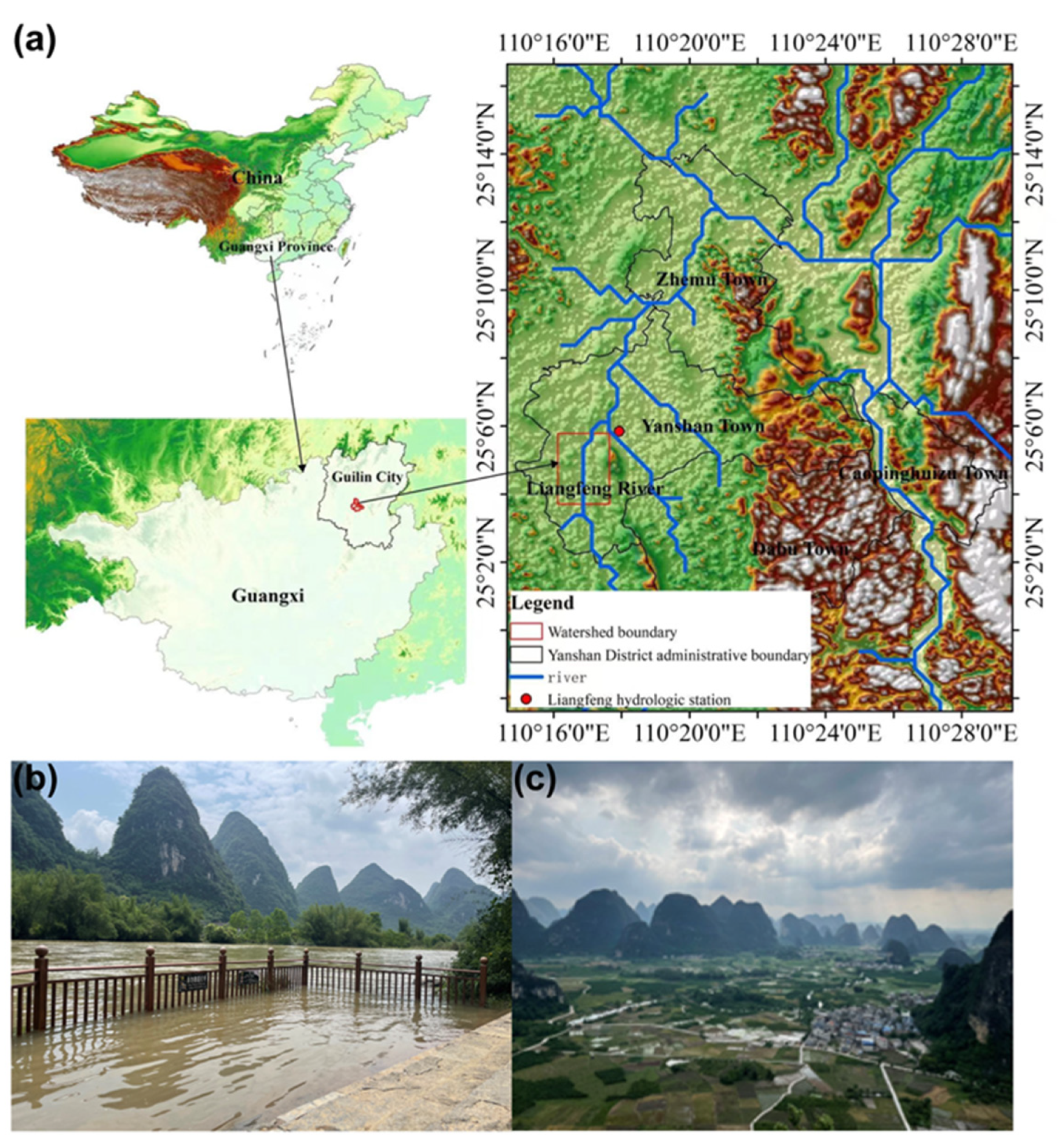
The study area, the Liangfeng River basin (Figure 1a), is located in the southern part of Guilin City, spanning from 109°36′ to 111°29′ east longitude and 24°15′ to 26°23′ north latitude. The Guilin karst heritage site, situated on the third terrace of China’s topography, lies at elevations ranging from 200 to 800 m above sea level. Characterized by unique regional structures and a basin topography, the area has fostered the development of expansive and contiguous peak-cluster and peak-forest karst formations (Figure 1b,c) on a robust and compact layer of limestone, extending up to 3 km in thickness and composed mainly of pure carbonate rocks. Its climate falls under the classification of a mid-subtropical humid monsoon, characterized by mild temperatures and abundant rainfall. The annual average temperature is 18.9 °C, with an average of 1670 h of sunshine annually. January marks the coldest month, with an average temperature of 15.6 °C, while August records the highest temperature, averaging at 23 °C. The frost-free period extends for approximately 300 days per year. Annual precipitation averages 1949 mm, exhibiting an uneven distribution throughout the year, with autumn and winter being relatively dry, while peak rainfalls occur during May and June. The annual average evaporation ranges between 1490 and 1905 mm.
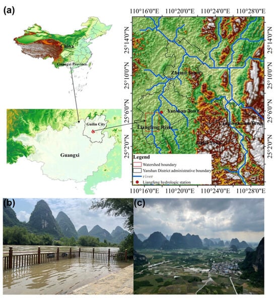
Figure 1.
The location and hydrological map of the Liangfeng River basin (a) and typical peak-forest karst in the study area (b,c).
The Liangfeng River, a primary tributary of the Lijiang River, has a drainage area of 504 km2 and an average annual flow of 21.2 m3/s, featuring a diverse karst topography. The river plays a significant role in water supply, transportation, and the local economy, serving as a primary source of drinking water for areas such as Yanshan Town. It frequently faces flood threats during the rainy season (which overlaps with the peak tourist season), posing substantial risks to human life and properties. The thriving tourism industry attracts a large number of domestic and international visitors; however, over/underestimating flood risks can lead to economic losses, including wasted resources and lost tourism revenue. Therefore, precise flood forecasting is crucial for policymakers to effectively manage the river.
2.2. Research Methodology
2.2.1. HEC-HMS Model Establishment and Its Extensions
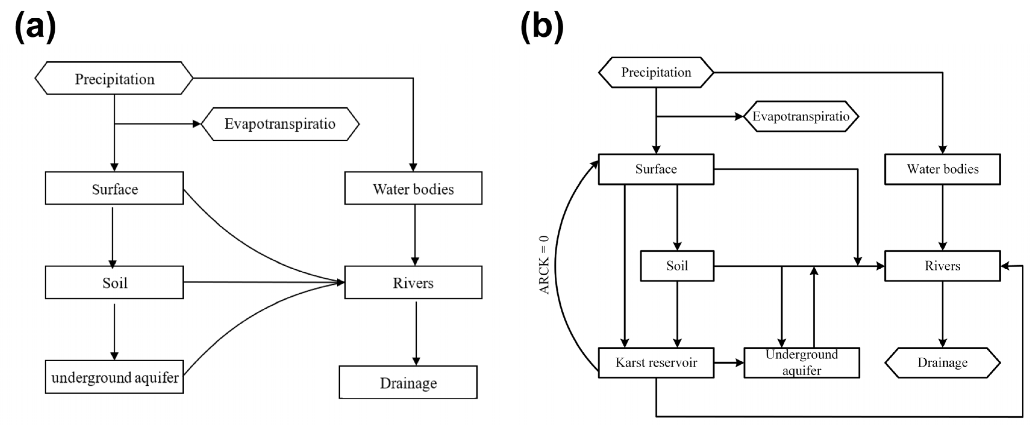
This study employed the HEC-GeoHMS extension module within the GIS for preliminary data processing. High-resolution raster data with a precision of 12.5 m were utilized (obtained from the Spanish National Geographic Institute’s website CNIG, 2017), and the desired boundaries and shapes of the watershed were derived through clipping and stitching processes. Following this, a series of procedures, including depression filling, flow direction computation, flow accumulation calculation, river network extraction, sub-basin delineation, and watershed and river network vectorization, were conducted on the processed DEM data to construct a base map model. It is worth noting that although the GIS can automatically designate river networks from DEM layers by considering watershed topography, there may be instances where valleys and other low-lying areas in regions of low elevation are erroneously identified as rivers. Hence, it is imperative to validate the constructed model against actual rivers and terrain to calibrate the results. Subsequently, the generated basin file was imported into the HEC-HMS. The model consists primarily of four modules, namely, the precipitation–runoff, routing, baseflow, and river flood routing, with each corresponding to specific hydrological processes, as illustrated in Figure 2a.

Figure 2.
The HEC-HMS model hydrological principles diagram (a) and the adopted diagram for the karstic watershed (b).
In this diagram, there are four basic modules. Surface runoff modules are employed to compute how runoff flows over hillslopes, encompassing hydrological methods (various unit hydrograph approaches) and hydraulic methods (such as dynamic wave equations). Baseflow represents the continuous or rainfall-free runoff that steadily discharges into streams from the system, and it is utilized to describe how the subsurface drainage slowly releases into the river channels, with commonly used methods including the constant monthly, exponential recession, and linear reservoir. River channel evolution models aim to calculate the movement of water within the river channels, with commonly employed methods including the kinematic wave, Lag, and Muskingum.
In this work, for the karstic watershed application, ARCK was connected with these four basic modules, considering the hydrological principles of the model. As presented in Figure 2b, part of the precipitation generates runoff through the surface or soil and the other part flows directly or through the soil, infiltrating into karst reservoirs. Some of this stored water in the reservoir flows into the groundwater aquifers, while others directly enter the river. When these reservoirs are full (ARCK = 0), they will overflow to the surface at the same time. As shown in Figure 2b, the repeated cycle of this process has a significant impact on the runoff in karst areas.
For subsequent runoff calculations, the SCS-CN method was adopted based on data from small watershed storm events. The SCS-CN model is derived from an empirical hydrological model proposed based on the water balance equation and two fundamental assumptions. One is that “the ratio of the actual surface runoff of the catchment area to the possible maximum runoff of the basin is equal to the ratio of actual infiltration to potential storage capacity”, and the second is that “the initial loss is a part of the potential storage capacity” [33]. The curve numbers (CNs), as a crucial parameter, represent estimated values of the soil moisture group (HSG) function, land cover/land use types, hydrological conditions, antecedent runoff conditions (ARCs), and different proportions of basin area, characterizing the runoff potential of various land surfaces [34,35].
The Liangfeng River basin is situated in a region with abundant rainfall, where the SCS model better approximates the mechanism of full rainfall runoff. In this work, information on basin soil types was obtained from the Food and Agriculture Organization (FAO) portal at (https://www.fao.org/soils-portal/data, (accessed on 27 June 2024)). Based on the obtained satellite data, the land use structure in the Liangfeng River basin remains relatively stable, with agriculture being the predominant activity in this region, while forest and arable land constitute the primary land use types, accounting for 71.43 and 21.08% of the total area, respectively. Considering the hydrometeorological characteristics of the study area, distribution of soil types, land use classifications, and simulations of various combination scenarios, the three methods applied in this work included the Snyder Unit Hydrograph, exponential recession, and Muskingum methods.
2.2.2. ARCK Inclusion
Integrating ARCK into HEC-HMS to enhance model prediction accuracy is evidently imperative [36]. However, the direct computation of ARCK’s specific values is practically infeasible, because karst areas have countless hidden pipes, cracks, caves, sinkholes, etc., which are unmeasurable. Through the reservoir module in the model, different sizes of reservoir can be added into sub-basins based on real reservoir data (if any). The karstic hidden networks’ impact (collectively) during the flood formation is similar to a natural slow-release reservoir, which is able to store the flow until it is filled with the stormwater. Although there is no actual reservoir in the Liangfeng River Basin, due to the karstic nature of the basin, the flood characteristics are being regulated by the hidden karstic reservoirs; therefore, via building virtual reservoirs in the HEC-HMS model, the flood simulation results in this basin were found closer to the actual situations. We incorporated several reservoirs of varying sizes into the model based on the functional relationships among rainfall, runoff, and time intervals. We used the HEC-HMS reservoir module to establish a reservoir in each sub-watershed to represent the impact of ARCK in the region. This necessitated the consideration of hydraulic connections among sub-basins, channels, and flow paths to ensure smooth model operation. These reservoirs function akin to the myriad hidden karstic voids, crevices, etc., greatly impacting the region’s runoff dynamics. Because the function of ARCK is similar to that of a reservoir, continuous rainfall events cause a gradual depletion of ARCK, analogous to the regulation process of a reservoir. As the reservoir’s capacity reaches different thresholds during and after the precipitation, it releases water at different discharge rates, paralleling the situation where ARCK is reduced to zero, leading to overflow and subsequent runoff. In this study, the predictive performance of the HEC-HMS model before and after the ARCK inclusion was compared to validate this process.
As shown in Figure 3, in karst regions, the reservoir types related to ARCK were classified into three distinct types, named A, B, and C. This classification was based solely on their discharge rate characteristics, not on their capacities. Both types A and B resemble reservoirs, differing mainly in the size of their conduits (A > B). Type C, on the other hand, represents a shaft [37]. In karstic watersheds, the generated runoff can be categorized into runoff from reservoirs, conduits, surrounding soil, and additional stormwater collected below the conduits. When rainfall occurs, water passing through type C is not stored but quickly flows through the conduit during a short transfer time. For type A, rainfall is held in the reservoir and simultaneously released at a slow rate. As rainfall increases, the reservoir’s water level rises, resulting in higher water pressure and an increased outflow, gradually influencing the runoff volume. When the reservoir reaches its capacity threshold, the outflow peaks, and subsequent rainfall overflows from the top of the reservoir, more significantly influencing the total runoff.
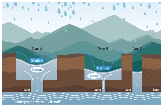
Figure 3.
Three distinct types of karst reservoir related to ARCK runoff generation.
Type B, with its narrower and nearly sealed conduit, produces minimal runoff initially. During the filling period, it generates only a negligible amount of runoff. As the reservoir is being fully saturated, substantial runoff occurs from the top of the reservoir, while higher pressure increases the drainage rate at the bottom. These dynamics result in different runoff conversion times for the three abovementioned ARCK types. In summary, type A has a moderate conversion time, storing and gradually converting rainwater into runoff; type B, the slowest, contributes more when the ARCK is near zero, and type C has the fastest conversion, as rainwater directly flows through the conduit.
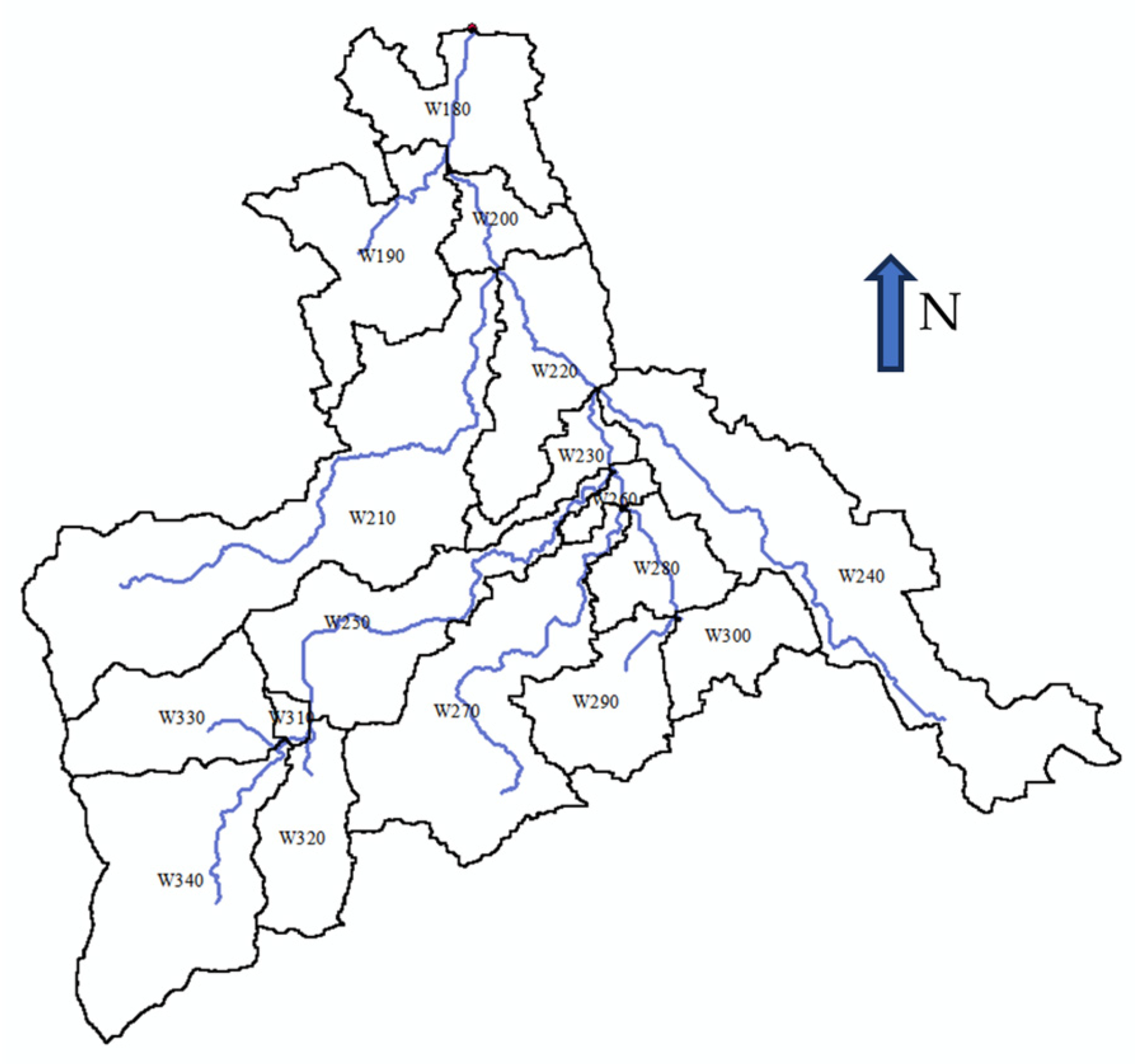
Based on the natural topography and geomorphology of the Liangfeng River basin, with a focus on distinguishing karst regions from non-karst regions, we split and merged sub-basins. The basin was divided into 17 sub-basins, labeled as W180, W190, …, W340 (Figure 4). Since each sub-basin contains varying extents of karst landscapes, virtual reservoirs of different sizes were constructed. Each sub-basin was assigned a reservoir, corresponding to R180, R190, …, R340, respectively.
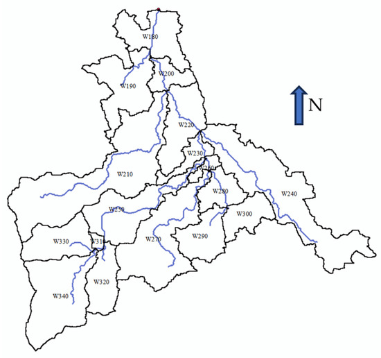
Figure 4.
Division of sub-basins and the river network in Liangfeng River basin.
Although the relationship among their storage capacity, water level, and flow rate varies, these 17 reservoirs can collectively influence approximately 96.5 m3/s of runoff at their peak. The maximum discharge rate of each reservoir was determined based on two parameters: the size of its corresponding sub-basin and the total area covered by karst in each particular sub-basin (estimated through topographic maps and a site study). Generally, the larger the size of the sub-basins or the karstic area percentage, the greater the reservoir capacity and, thus, the greater the impact on runoff. The maximum contribution rate and the total volume of runoff-holding capacity of these 17 reservoirs (96.5 m3/s and 2.19 × 10⁶ m3, respectively) were estimated from the difference between the simulated and real flood values. The total capacity and the maximum discharge rate of each reservoir were determined through multiplying the sub-basin area relative to the total watershed area, the percentage of the sub-basin covered by karst features, and the difference between the real and simulated flood volume and peak discharge, as in Equations (1) and (2):
where VRn represents the nth reservoir capacity in m3, An is the nth sub-basin area, At is the total watershed area, AKn is the percentage of the nth sub-basin covered by karst, (in m3) is the difference between the simulated and real flood volumes, QRn is the nth reservoir peak discharge rate, and is the difference between the simulated and real flood peak discharge rate, mutually in m3/s.
For instance, the largest sub-basin, W210, with an area of 47 km2, does not host the largest reservoir. Instead, the largest reservoir, R250, is located in sub-basin W250, with an area of 19 km2 (ranked 5th in size among the 17), with a capacity of 11,000 m3, which can influence over 10 m3/s of runoff at its peak discharge rate. This is because, compared to the former, the latter has more karstic features, including approximately 70% sinkholes, vertical shafts, and a large swallow hole (Figure 4).
As the ARCK varies with real-time environmental changes, virtual reservoir construction must consider two types of rainfall–runoff scenarios, as it directly affects how much rainwater is converted into runoff in the region. During the dry season, when rainfall is lesser and sparse, the stored rainwater in reservoirs has already been drained. In this season, the ARCK is generally at its maximum and, hence, larger storage capacities are assigned to reservoirs compared to the rainy season. This larger available capacity can detain the rainwater, so the produced runoff will be minimal. In this season with high ARCK, when it rains, a larger portion of rainfall is stored in the 17 virtual reservoirs and, therefore, less surface runoff is produced and less changes in the river’s water level can be observed. In the rainy season, however, when rainfall is concentrated and runoff is substantial, the capacity of ARCK is reduced continuously, as the rainfall has partially filled the ARCK, and the transformation rate of rainfall into runoff becomes higher to a point that even light rainfalls might produce significant runoff. Under this scenario, the gradient of the functional equations is increased to better manage the flow through the reservoir capacity [38]. The linear reservoir model (Equations (3) and (4)) can illustrate this point:
where is the rate of change in water storage capacity over time, is the average inflow at time t, and is the outflow rate at time t.
In a linear reservoir, the relationship between storage capacity and discharge at time t is:
where S is the storage capacity at time t and represents a constant linear reservoir parameter.
During the rainy season, due to the lower ARCK value, the corresponding water storage capacity is higher, resulting in higher conversion rates of rainfall to runoff. Considering 60 years of rainfall–runoff data records of the Guilin watershed, 70% of the total rainfall volume (averagely) occurs during the rainy season from May to August and, hence, the ARCK was designed to have different storage capacities in these two (dry and rainy) seasons, proportionally. The importance of the seasonal variation is also attributed to the time intervals. A longer interval results in a higher ARCK, even if it takes place during the rainy season. Therefore, calibrations for the ARCK contribution rates in any simulated flood are vital, taking intervals into consideration.
Each reservoir is an independent unit in the model, but they collectively represent all the rainwater held in the buried caves, cracks, sinkholes, vertical wells, etc., in the entire karst basin, reflecting the values that could not have been calculated in the model, unless in the form of a reservoir. Moreover, although real reservoirs typically account for evaporation, the design of virtual reservoirs focused on flow regulation, excluding evaporation. This omission underscores the advantage of virtual reservoir construction in flood management scenarios, where the rapid onset of floods typically precludes significant evaporation effects [39].
In our study, via establishing a modified Plus evolution model and water-blocking model (Equations (5) and (6), respectively) in HEC-HMS, the joint effects of virtual reservoirs and ARCK were represented [40,41]. The former method splits up the time and decomposes it into a series of equal time, ∆t. Under the initial condition, when t = 0, its value is determined, and each subsequent time interval can be calculated by the previous one. The principle of the water-blocking model is to control the flow rate based on the characteristics of the reservoir and spillway. It establishes a functional relationship between storage capacity and outflow, linking the water level height with outflow. Before the volume of the water in the reservoir exceeds its full capacity, water is being stored/released and only overflows when a certain threshold is reached. Similarly, the ARCK also affects the outflow of the karst reservoirs, as the outflow here is controlled by the magnitude of the water head. For the modified Plus evolution model:
where denotes the time interval index, and represent the inflow values at the beginning and end of the -th time interval, respectively, and are the corresponding outflow values, and and are the corresponding storage values, while in the water-blocking model:
in which O represents the flow, denotes the flow coefficient, denotes the cross-sectional area of the obstruction orthogonal to the water flow direction, g represents the gravity coefficient, and signifies the total head.
In addition, due to the hydrogeological differences between the karstic sub-basins, the respective virtual reservoirs constructed in the model also respond differently to the rainfalls, generating various amounts of runoff even for similarly sized sub-watersheds. In this study, the Muskingum method (Equation (7)) was used to regulate (to some extent) these differences. The time of flood propagation in the river or traveling time (K value in this method) has an impact on advancing or delaying the peak time. The larger the karst area, the larger the K value, because rainwater has to flow out through karst channels for a longer time.
where I represents inflow, O represents outflow velocity, K denotes the flow traveling time, and X (0–0.5) is a dimensionless weight as a proportion of the prism and wedge storage.
3. Results and Analyses
3.1. Initial Model
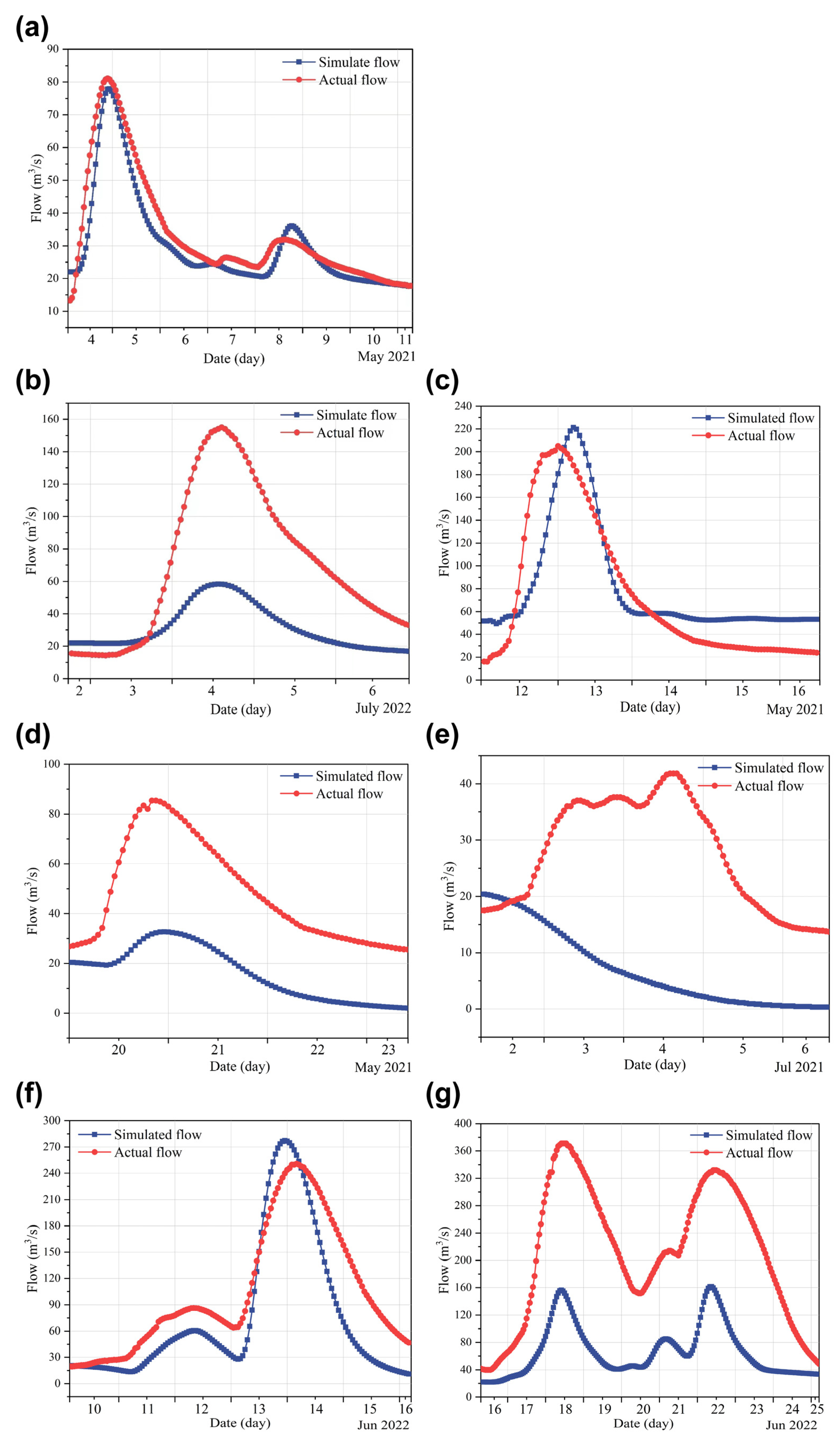
Hydrological models are essential to be calibrated and validated [42], and for this purpose, the current study used five flood events (Figure 5a–e). By inputting hourly rainfall–runoff data of these floods, the model outputs were analyzed. Through the Snyder Unit Hydrograph, exponential recession, and Muskingum methods, combined with the CN value of the basin (between 75 and 85), using the trial-and-error method of different parameters (including CN, initial abstraction, impervious rate, lag time, K, X, etc.), the five flood events were analyzed to determine a set of parameters suitable for the basin until the shape of the simulated flood hydrograph was similar to that of the real scenario. Then, another two floods were used for validation (Figure 5f,g). Similarly, we used the previously determined parameters to input the hourly rainfall–runoff data of these two floods and observed the shape of the simulated hydrographs compared with the measured hydrographs. As the parameters were relatively close, therefore, the model was reliable and ready to use. The Nash–Sutcliffe efficiency coefficient (NSE) is an indicator used to verify the quality of hydrological model simulation results and usually to evaluate the accuracy and reliability of model predictions. NSE values range from −∞ to 1. The higher this value, the better the fit between the predicted results of the model and the actual observational data, and the better the performance of the model [43]. In the unaltered initial model, although a portion of the simulations achieved acceptable results (with the NSE reaching above 0.8 (Figure 5a), with a satisfactory hydrograph shape, arrival time of peaks, and even the occurrence of secondary peaks in floods), since the ARCK’s influence on runoff was not considered yet, both peak flows and total runoff volumes showed extremely poor simulation results for 10 noticeable rainfall events in the region over 2 years (Figure 5b–g, as examples).

Figure 5.
The initial HEC-HMS simulation of six rainfall events: one with a high Nash value (a) and the others with poor simulation accuracy (b–g).
Through analyzing the patterns over two years, it was observed that in months with scarce rainfall, such as January–April 2021, July 2021–April 2022, and August–December 2022, even heavy rainfall events did not generate considerable runoff but only produced a base flow or minimal runoff (the highest peak was 78 m3/s). This was most probably due to the long intervals, which maximize the ARCK. Conversely, during the wet season (e.g., May–July 2021 and 2022), with concentrated rainfalls, even relatively light precipitations generated significant runoff (reaching up to 350 m3/s).
During late February to mid-March 2021, there was a total rainfall of 187 mm during two weeks of (almost every day) rain. However, the river water level rise was not considerable until the last few days of this period, which also did not last long. Since this was after a long dry season of autumn and winter, we assumed that a major part of the produced runoff flowed into the karstic reservoirs and reduced the ARCK. During the following months when the rainy season began, there were 65 rainy days over 3 months. Here, we can see a clear rise in water level in the river in general, and as a response to each rainfall event. This could be due to no (or low) available capacity of karst reservoirs and the full conversion of rainfall to runoff.
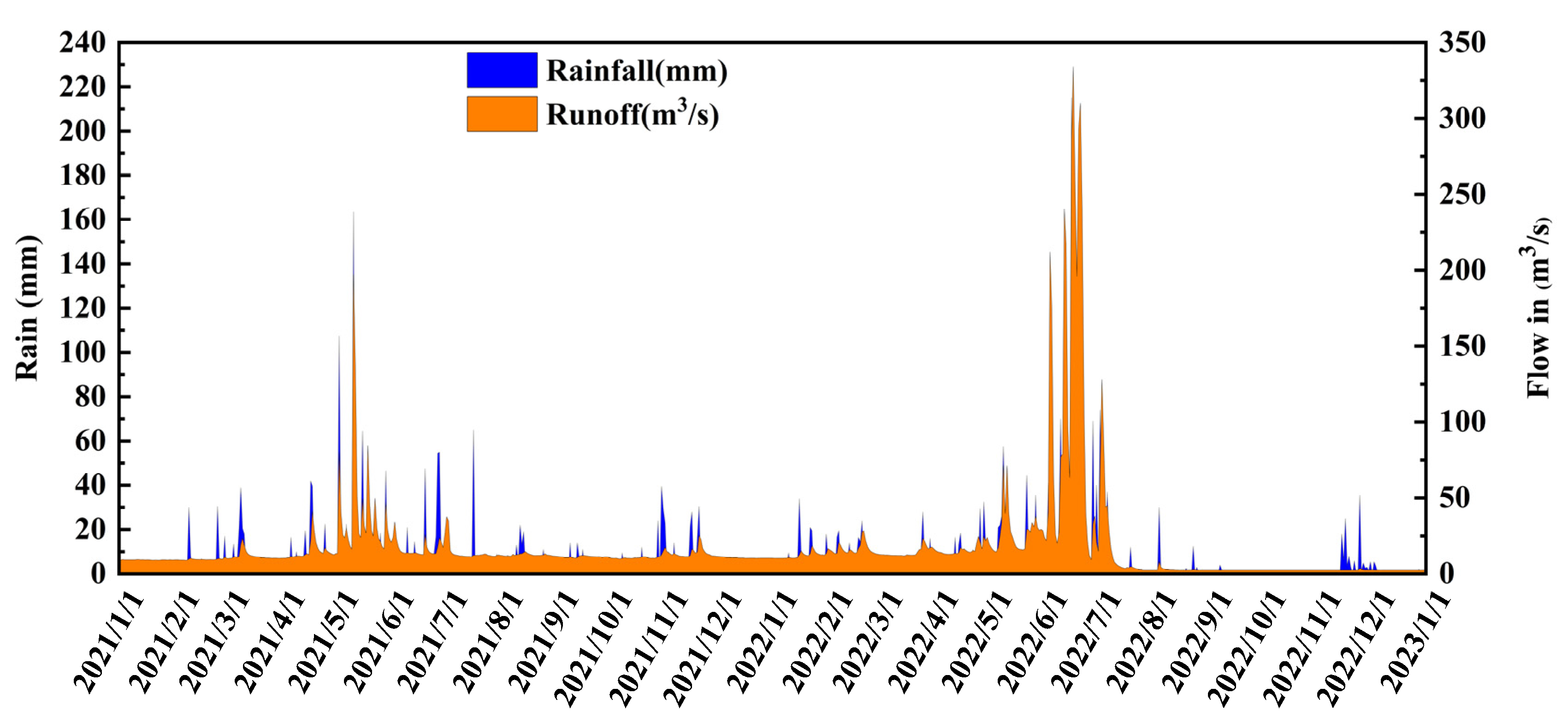
A single event on 18 July 2021 with 65 mm of rainfall, which did occur after a two-week interval, is highlighted in Figure 6. As can be seen, again, there was no change in the water flow in response to this considerable precipitation, since the long interval caused a higher ARCK, as the reservoirs were mostly drained during the two weeks, and hence, most of the rainwater was just stored in the voids and karstic structures. Similar situations could be seen in early August 2022, and mid-November to early December 2022. Such cases, which show the importance of ARCK in flood forecasting, can be exemplified in Guilin karstic watershed areas.
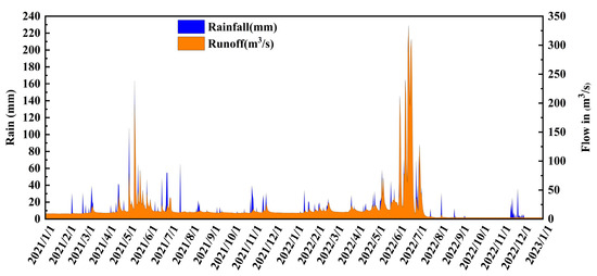
Figure 6.
Runoff in response to rainfall in the Liangfeng River basin during 2021 and 2022.
Analyzing this phenomenon, in which rainfall and runoff are not directly proportional, they exhibited certain patterns under the action of ARCK, likely due to elevated/lowered ARCK values during the dry/wet season. Therefore, when designing virtual reservoirs, different capacities should be considered for different seasons. This can facilitate preliminary flood forecasting, considering three dimensions—the duration and intervals of rainfall, drought conditions, and rainfall volume—as (to some extent) indicated in a few studies [44,45].
3.2. Modified Model
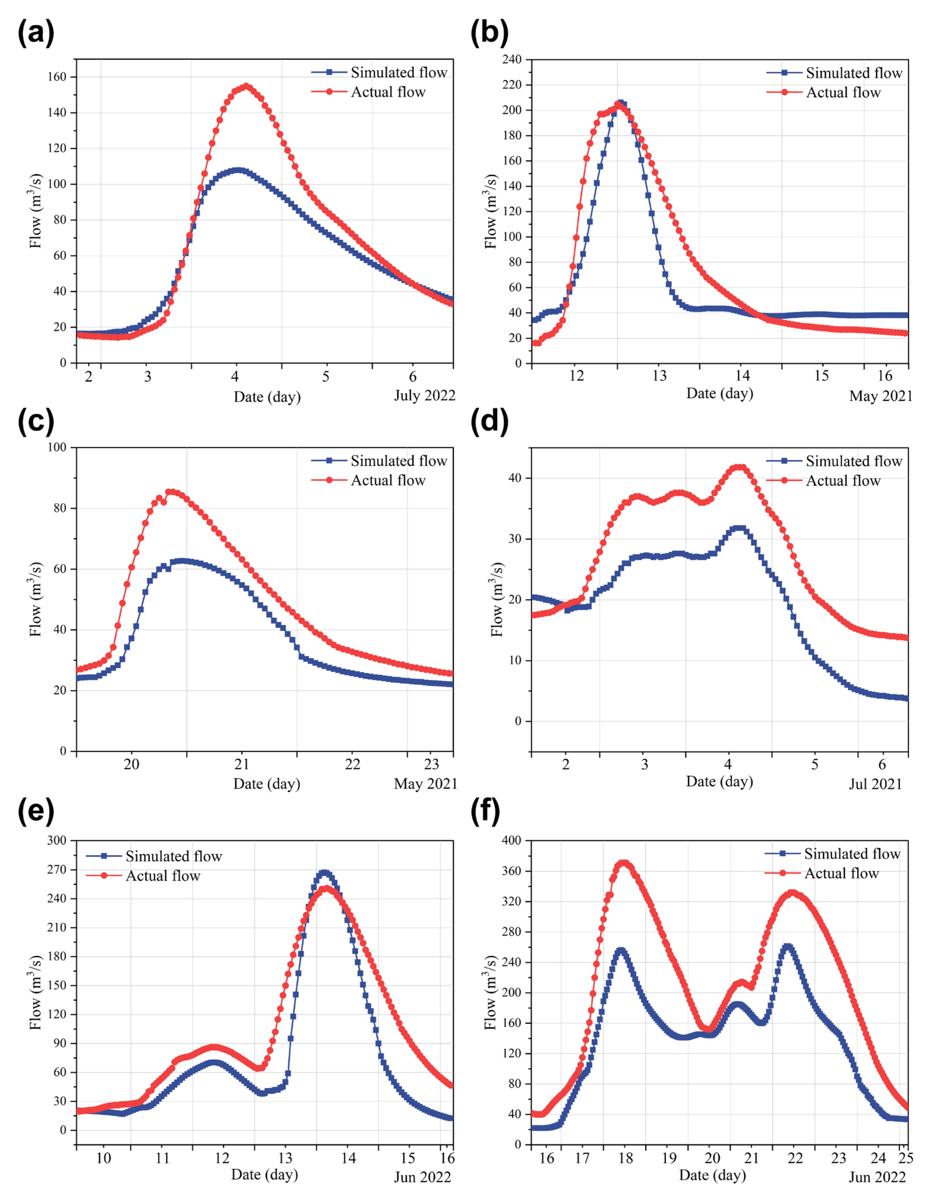
We note that very few rainfall events have achieved good simulation results. The reason may be that the parameter calibration is more accurate, and in most applications of HEC-HMS, the simulation results are always mixed, because they are based on mathematical formulas and there are errors. Moreover, when the cause of inaccuracy is the karstic structure of the basin, in some cases (certain seasons, certain rainfall intervals, and certain holding capacity of rainwater by karst structure), the condition might be similar to those watersheds that the original model was designed for; hence, good results can be achieved. Through analyzing the related flood for the precipitation event during the rainy season in the Liangfeng River basin on 3 June 2022 (as an example), it can be seen that the role of virtual reservoirs as representatives of ARCK in releasing runoff significantly improved the simulated hydrograph. This improvement was due to the added virtual reservoirs (representing the role of ARCK), which changed the runoff generated by rainfall at each point in time, making the simulated hydrograph more similar to the real one. The flood hydrograph shapes in the model closely matched the real scenarios, validating most of the parameters.
Most rainfall and runoff events (peaks and total runoff volumes) showed improved fitting after the ARCK was included in the total runoff calculation by the model, enhancing its accuracy. Among the 10 major rainfall events screened from 2021 to 2022, Figure 7 shows the average simulation accuracy increased by 34% (from 0.47 to 0.63, on average). The disparity between the flood peak and flow rate for the unmodified model (such as in Figure 5b) indicates that for the Liangfeng River basin, the most influential factors on the model were the CN value and imperviousness, both related to the characteristics of the basin’s underlying surface, with relatively fixed values. Thus, this disparity is attributed to the impact of ARCK. Runoff in the Liangfeng River basin follows typical karst basin patterns, characterized by periodic runoff generation, akin to a reservoir releasing water, mainly during the rainy season. Baseflow remained relatively stable, in the range of 3–10 m3/s.
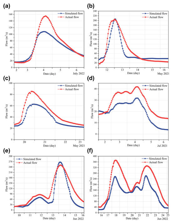
Figure 7.
Simulated hydrograph (blue line) versus actual hydrograph (red line) for the rainfall event (compared with Figure 6b–f) after incorporating the ARCK into the HEC-HMS model. (a–f) are the runoff results of 6 different dates simulated by the modified model).
With reduced rainfall, the water level in karstic structures decreased and the ARCK increased, in accordance with the storage and discharge equations. This process is similar to the sink–source function, with some modifications required [46]. During the initial model calibration, parameters were determined based on high ARCK values, leading to the design of multiple virtual reservoirs, as the Liangfeng River basin is predominantly in a process of continuous ARCK filling. Considering the storage capacity of the reservoir and the actual annual rainfall runoff situation, the virtual reservoir requires the frequent calculation of new parameters. Because ARCK is an environmental variable, even the same sub-basin can change in different years. Moreover, as precipitation events occur frequently, new runoff will also be generated concurrently with the filling/draining of the ARCK, aligning the reservoir-filling process with final runoff production, in accordance with hydrological principles. Essentially, the first and second rainfall scenarios constitute a continuous repetitive process within the basin. This underscores the ongoing need to account for such dynamics within hydrological models, which conventionally rely on functional equations to quantify these phenomena [47,48,49].
Considering the relatively small runoff volume in the Liangfeng River basin, integrating virtual reservoirs into the model allowed for effective runoff regulation and yielded satisfactory simulation results. In larger karst basins with more complex hydraulic interactions and numerous sub-basins, additional reservoir elements are required to represent ARCK and control runoff, but the simulation outcomes remain uncertain. Combining earlier soil conditions (AMC values) and fixed initial abstractions, constructing new reservoirs using actual dam elements will yield better simulation results, necessitating a more intricate ARCK calculation [50,51]. Leveraging these observations, alongside model simulations and rainfall data, enables more accurate forecasting.
3.3. Uncertainties and Explanations
Although the NSE of the enhanced model was significantly improved compared with that of the original model, there were still certain gaps with the measured values. After analysis, the causes of this could be mainly divided into the complexity of karst hydrology and the algorithm of the model itself. The analysis of karst basins and the low accuracy of hydrological models have been described above, so here we focus on the reasons for the model itself.
Firstly, DEM processing is an important part of the model. Because the establishment of the base map in the early stage is completed in GIS, DEM is used to extract the characteristic values of the watershed, divide the watershed, establish the water outlet, and for a series of other work. The accuracy of DEM may lead to misjudgment of topography and make the depression-filling process (filling in the center of the depression where the grid units are lower than the neighboring units) inaccurate, which may cause an inaccurately calculated water flow direction. This will further affect the hydrological process simulation of the whole basin. A study in Liulin basin showed that the flood simulation results of the HEC-HMS model based on 1 m-resolution DEM were better than those of a 30 m-resolution model based on DEM [52].
In the meteorological module, the inverse distance weight interpolation method (IDW) was used. By calculating the distance between grid nodes, known points, and the weight coefficient, interpolation was carried out to calculate the distance between each sub-basin and the site. Since there is only one hydrological station in this basin, the Tyson polygon, which is a more common method, could not be used. However, this method is suitable for the case where the distribution of discrete points is relatively uniform, otherwise it may lead to bias in the interpolation result [53]. Moreover, the sub-basins in this study are more concentrated in the north and east, so there may be an overestimation/underestimation of rainfall. Besides, the unit hydrograph is a method to deduce flood processes from net rain processes, which is widely used in flood design and hydrological forecast [54]. However, its basic assumption is not completely consistent with the actual situation. The uneven spatial and temporal distribution of rainfall, nonlinear influence, and base flow segmentation error make the unit hydrograph analyzed by each flood different, or there is a jumping phenomenon. Obviously, the nonlinear relationship between rainfall and runoff in karst areas is an influencing factor. Therefore, the unit-line method we used in this study may lead to deviations between the measured versus the simulated results. Hence, in the future research, we can consider using higher-precision DEM, integrated hydraulic linkage, and spatial distribution when dividing sub-watersheds, and use the MATLAB (R2023a version) to improve the nonlinear algorithm and the prediction accuracy of this model.
Uncertainty is an inherent part of any scientific study and is reflected in the methods, concepts, and data presented in this paper. In terms of method, the essence of the model is a mathematical formula to overcome the limitations of experimental methods, such as whether a certain area will be flooded under a rainstorm, how much of a river or network flows under rainfall, the severity of drought in a particular watershed, whether the dam has an impact on the hydrological regime of the basin, etc. Conceptually, there are countless hidden caves and shafts in karst areas. Obviously, the current research cannot quantitatively treat each structure. In fact, there is a gap in each cave itself, and their hydraulic connection is not exactly the same. The watershed includes the natural principles, which cause a rapid response of water flow to rainfall events in karst areas and the rapid diffusion and transportation of the karst aquifer solution pipe network [55].
We also mentioned the uncertainty brought by formulas such as the spatial interpolation method and flood path calculation. At present, it seems that the improved algorithm can improve the prediction accuracy of the model, but it is not in the scope of this paper. The rainfall runoff field data selected in this study were complete, and the missing values were not filled in by the interpolation method, which makes the results reliable to the maximum extent. However, it is inevitable that there will be deviations in the process of model calculation (such as the calculation process of the distribution of point rainfall to area rainfall, and whether the value of the calibration parameter may be better). All of these factors contribute to this uncertainty. However, the accuracy of the model is improved when the research method and concept are not wrong, which shows that the research is feasible. Based on the scope of this study, building a greater number of reservoirs at smaller scales may improve the prediction accuracy of the model. This approach can be considered in larger watersheds to assess the proposed method’s applicability.
4. Conclusions
The ARCK (Available Reservoir Capacity of Karst) could be used to modify the HEC-HMS model, yielding significant improvements with an average accuracy increase of over 34%. This was achieved by constructing virtual reservoirs in different sub-watersheds to represent the effect of ARCK.
In the Liangfeng River basin, a small karst watershed, the precipitation–runoff relationship exhibited the following characteristics: prolonged intervals between rainfall events (including heavy rainfall) avoided significant increases in flow rates, whereas shorter intervals between rainfall events (even light rain) might result in substantial changes in flow rates. Seasonal variations influenced this characteristic. During the dry season, the ARCK value was higher, meaning that even short-interval rainfall (including heavy rainfall) did not cause significant flow changes. Conversely, during the rainy season, the ARCK value was lower, causing even light rainfalls to trigger sharp increases in flow rates, with higher runoff frequencies.
The impact of ARCK on rainfall–runoff was categorized into three types of karst landscapes: A, B, and C. Type A generated runoff immediately upon rainfall, with an increasing rate as rainfall continued, and had a moderate conversion time from rainfall to runoff. Type B only converted to runoff after a certain period following rainfall, with the longest conversion time. Type C produced runoff at a constant, relatively low rate upon rainfall. Seasonal variations assigned different ARCKs influencing the river flow rates. Regardless of the season, the quantity and size of type C remained stable and constituted the smallest proportion among the three types. During the dry season, type A was less prevalent, while type B was more common, with larger capacities. In contrast, this situation was reversed during the rainy season.
Author Contributions
L.L., investigation, modeling, data analysis, writing—original draft preparation; S.R., investigation, data analysis, writing—review and editing; J.D., writing—review and editing, data acquisition; A.S., supervision; J.X., data acquisition; R.X., editing. All authors have read and agreed to the published version of the manuscript.
Funding
The financial support for this work was received from the National Natural Science Foundation of China (No. 52150410408), the Science and Technology Planning Project of Guangxi, China (No. AB 23026045), and the Science and Technology Plan Project of Guilin (No. 20220114-2).
Institutional Review Board Statement
Not applicable.
Informed Consent Statement
Not applicable.
Data Availability Statement
The data presented in this study are available on request from the corresponding author.
Conflicts of Interest
The authors declare no conflict of interest.
References
- Zhou, L.; Zhao, Y.; Zhu, C.; Shi, C. Route Selection for Scenic Byways in Karst Areas Based on the Minimum Cumulative Resistance Model: A Case Study of the Nanpan–Beipan River Basin, China. Ecol. Indic. 2024, 163, 112093. [Google Scholar] [CrossRef]
- Chen, S.; Wei, X.; Cai, Y.; Li, H.; Li, L.; Pu, J. Spatiotemporal Evolution of Rocky Desertification and Soil Erosion in Karst Area of Chongqing and Its Driving Factors. Catena 2024, 242, 108108. [Google Scholar] [CrossRef]
- Fushan, L.; Guilin, H.; Yang, T. C-N Isotope Coupling along the Vertical Profiles under Different Land Use in a Typical Karst Area, Guizhou, Southwest China. Procedia Earth Planet. Sci. 2014, 10, 194–199. [Google Scholar] [CrossRef]
- Iacobellis, V.; Castorani, A.; Di Santo, A.R.; Gioia, A. Rationale for Flood Prediction in Karst Endorheic Areas. J. Arid Environ. 2015, 112, 98–108. [Google Scholar] [CrossRef]
- Zhang, W.; Duan, L.; Liu, T.; Shi, Z.; Shi, X.; Chang, Y.; Qu, S.; Wang, G. A Hybrid Framework Based on LSTM for Predicting Karst Spring Discharge Using Historical Data. J. Hydrol. 2024, 633, 130946. [Google Scholar] [CrossRef]
- Guan, N.; Cheng, J.; Bi, H.; Shi, X. Laboratory and Field Characterization of Preferential Flow under Consideration of Geometric Fracture Features in a Karst Region in Southwest China. J. Hydrol. 2024, 631, 130851. [Google Scholar] [CrossRef]
- Xu, X.; Yan, Y.; Dai, Q.; Yi, X.; Hu, Z.; Cen, L. Spatial and Temporal Dynamics of Rainfall Erosivity in the Karst Region of Southwest China: Interannual and Seasonal Changes. Catena 2023, 221, 106763. [Google Scholar] [CrossRef]
- Baraza, T.; Hasenmueller, E.A. Floods Enhance the Abundance and Diversity of Anthropogenic Microparticles (Including Microplastics and Treated Cellulose) Transported through Karst Systems. Water Res. 2023, 242, 120204. [Google Scholar] [CrossRef] [PubMed]
- He, G.; Zhao, X.; Yu, M. Exploring the Multiple Disturbances of Karst Landscape in Guilin World Heritage Site, China. Catena 2021, 203, 105349. [Google Scholar] [CrossRef]
- Husic, A.; Al-Aamery, N.; Fox, J.F. Simulating Hydrologic Pathway Contributions in Fluvial and Karst Settings: An Evaluation of Conceptual, Physically Based, and Deep Learning Modeling Approaches. J. Hydrol. X 2022, 17, 100134. [Google Scholar] [CrossRef]
- Yan, Y.; Dai, Q.; Yuan, Y.; Peng, X.; Zhao, L.; Yang, J. Effects of Rainfall Intensity on Runoff and Sediment Yields on Bare Slopes in a Karst Area, SW China. Geoderma 2018, 330, 30–40. [Google Scholar] [CrossRef]
- Chen, T.; Wang, Y.; Peng, L. Exploring Social-Ecological System Resilience in South China Karst: Quantification, Interaction and Policy Implication. Geogr. Sustain. 2024, 5, 289–301. [Google Scholar] [CrossRef]
- Siou, L.K.A.; Johannet, A.; Borrell, V.; Pistre, S. Complexity Selection of a Neural Network Model for Karst Flood Forecasting: The Case of the Lez Basin (Southern France). J. Hydrol. 2011, 403, 367–380. [Google Scholar] [CrossRef]
- Guo, Y.; Huang, F.; Chi, F.; Zhang, N.; Ma, J.; Miao, Y.; Chen, F. Hydrogeological Structures of Karst Features Using Hydrographs in an Underground River Basin Formed in a Peak Cluster Depression, Southwest China. J. Hydrol. 2024, 634, 131085. [Google Scholar] [CrossRef]
- Chen, L.; Deng, J.; Yang, W.; Chen, H. Hydrological Modelling of Large-Scale Karst-Dominated Basin Using a Grid-Based Distributed Karst Hydrological Model. J. Hydrol. 2024, 628, 130459. [Google Scholar] [CrossRef]
- Chen, S.; Xiong, L.; Zeng, L.; Kim, J.-S.; Zhang, Q.; Jiang, C. Distributed Rainfall-Runoff Simulation for a Large-Scale Karst Catchment by Incorporating Landform and Topography into the DDRM Model Parameters. J. Hydrol. 2022, 610, 127853. [Google Scholar] [CrossRef]
- Duran, L.; Gill, L. Modeling Spring Flow of an Irish Karst Catchment Using Modflow-USG with CLN. J. Hydrol. 2021, 597, 125971. [Google Scholar] [CrossRef]
- Li, J.; Yuan, D.; Jiang, Y.; Liu, J. Elaborate Simulations of Floods in a Karst Trough Valley Basin with the Simplified Karst-Liuxihe Model. J. Hydrol. 2022, 614, 128504. [Google Scholar] [CrossRef]
- Li, J.; Yuan, D.; Liu, J.; Ma, M.; Li, Y. Evaluating the Effects of Water Exchange between Surface Rivers and Karst Aquifers on Surface Flood Simulations at Different Watershed Scales. J. Hydrol. 2023, 623, 129851. [Google Scholar] [CrossRef]
- Lin, Q.; Lin, B.; Zhang, D.; Wu, J. Web-Based Prototype System for Flood Simulation and Forecasting Based on the HEC-HMS Model. Environ. Model. Softw. 2022, 158, 105541. [Google Scholar] [CrossRef]
- Ren-Jun, Z. The Xinanjiang Model Applied in China. J. Hydrol. 1992, 135, 371–381. [Google Scholar] [CrossRef]
- Zhou, Q.; Chen, L.; Singh, V.P.; Zhou, J.; Chen, X.; Xiong, L. Rainfall-Runoff Simulation in Karst Dominated Areas Based on a Coupled Conceptual Hydrological Model. J. Hydrol. 2019, 573, 524–533. [Google Scholar] [CrossRef]
- Mo, C.; Wang, Y.; Ruan, Y.; Qin, J.; Zhang, M.; Sun, G.; Jin, J. The Effect of Karst System Occurrence on Flood Peaks in Small Watersheds, Southwest China. Hydrol. Res. 2021, 52, 305–322. [Google Scholar] [CrossRef]
- Arabi, M.; Govindaraju, R.S.; Hantush, M.M. A Probabilistic Approach for Analysis of Uncertainty in the Evaluation of Watershed Management Practices. J. Hydrol. 2007, 333, 459–471. [Google Scholar] [CrossRef]
- Oleyiblo, J.O. Application of HEC-HMS for Flood Forecasting in Misai and Wan’an Catchments in China. Water Sci. Eng. 2010, 3, 1. [Google Scholar]
- Palacios-Cabrera, T.; Valdes-Abellan, J.; Jodar-Abellan, A.; Rodrigo-Comino, J. Land-Use Changes and Precipitation Cycles to Understand Hydrodynamic Responses in Semiarid Mediterranean Karstic Watersheds. Sci. Total Environ. 2022, 819, 153182. [Google Scholar] [CrossRef] [PubMed]
- Guduru, J.U.; Jilo, N.B.; Rabba, Z.A.; Namara, W.G. Rainfall-Runoff Modeling Using HEC-HMS Model for Meki River Watershed, Rift Valley Basin, Ethiopia. J. Afr. Earth Sci. 2023, 197, 104743. [Google Scholar] [CrossRef]
- Alemu, G.T.; Ayalew, M.M.; Geremew, B.S.; Bihonegn, B.G.; Tareke, K.A. Evaluation of Semi-Distributed Hydrological Models Performance in Borkena Watershed; Upper Awash Basin, Ethiopia. Heliyon 2023, 9, e18030. [Google Scholar] [CrossRef] [PubMed]
- Mauri, L.; Tarolli, P. Modeling Windthrow Effects on Water Runoff and Hillslope Stability in a Mountain Catchment Affected by the VAIA Storm. Sci. Total Environ. 2023, 895, 164831. [Google Scholar] [CrossRef]
- Ju, Q.; Liu, X.; Zhang, D.; Shen, T.; Wang, Y.; Jiang, P.; Gu, H.; Yu, Z.; Fu, X. Application of Distributed Xin’anjiang Model of Melting Ice and Snow in Bahe River Basin. J. Hydrol. Reg. Stud. 2024, 51, 101638. [Google Scholar] [CrossRef]
- Dai, J.; Rad, S.; Xu, J.; Wan, Z.; Li, Z.; Pan, L.; Shahab, A. Influence of Karst Reservoir Capacity on Flood in Lijiang Basin Based on Modified HEC-HMS through Soil Moisture Accounting Loss. Atmosphere 2022, 13, 1544. [Google Scholar] [CrossRef]
- Zhang, X.; Huang, Z.; Lei, Q.; Yao, J.; Gong, L.; Sun, S.; Li, Y. Connectivity, Permeability and Flow Channelization in Fractured Karst Reservoirs: A Numerical Investigation Based on a Two-Dimensional Discrete Fracture-Cave Network Model. Adv. Water Resour. 2022, 161, 104142. [Google Scholar] [CrossRef]
- Amatya, D.M.; Walega, A.; Callahan, T.J.; Morrison, A.; Vulava, V.; Hitchcock, D.R.; Williams, T.M.; Epps, T. Storm Event Analysis of Four Forested Catchments on the Atlantic Coastal Plain Using a Modified SCS-CN Rainfall-Runoff Model. J. Hydrol. 2022, 608, 127772. [Google Scholar] [CrossRef]
- Liu, W.; Feng, Q.; Wang, R.; Chen, W. Effects of Initial Abstraction Ratios in SCS-CN Method on Runoff Prediction of Green Roofs in a Semi-Arid Region. Urban For. Urban Green. 2021, 65, 127331. [Google Scholar] [CrossRef]
- Jia, M.; He, D.; Huo, X.; Zhang, H.; Jia, S.; Zhang, J. Exploring the Impact of Climate Change on Flood Risk at Cultural Heritage Sites Using a GIS-Based SCS-CN Method: A Case Study of Shanxi Province, China. Int. J. Disaster Risk Reduct. 2023, 96, 103968. [Google Scholar] [CrossRef]
- Rad, S.; Junfeng, D.; Jingxuan, X.; Zitao, L.; Linyan, P.; Wan, Z.; Lin, L. Flood Characteristics and Implication of Karst Storage through Muskingum Flood Routing via HEC-HMS, S. China. Hydrol. Res. 2022, 53, 1480–1493. [Google Scholar] [CrossRef]
- Li, R.; Fan, J.; Zhao, W.; Jia, Y.; Xi, N.; Li, J.; Zhang, T.; Pu, J. High-Frequency Dynamics of CO2 Emission Flux and Its Influencing Factors in a Subtropical Karst Groundwater-Fed Reservoir, South China. Environ. Res. 2024, 251, 118552. [Google Scholar] [CrossRef] [PubMed]
- He, S.; Yan, Y.; Yu, K.; Xin, X.; Guzman, S.M.; Lu, J.; He, Z. Baseflow Estimation Based on a Self-Adaptive Non-Linear Reservoir Algorithm in a Rainy Watershed of Eastern China. J. Environ. Manag. 2023, 332, 117379. [Google Scholar] [CrossRef] [PubMed]
- Tu, T.; Li, Y.; Duan, K.; Zhao, T. Enhancing Physically Based Hydrological Modeling with an Ensemble of Machine-Learning Reservoir Operation Modules under Heavy Human Regulation Using Easily Accessible Data. J. Environ. Manag. 2024, 359, 121044. [Google Scholar] [CrossRef]
- U.S. Army Corps of Engineers. HEC-5: Simulation of Flood Control and Conservation Systems User’s Manual; Hydrologic Engineering Center: Davis, CA, USA, 1998.
- U.S. Army Corps of Engineers. Hydraulic Design of Spillways, EM 1110-2-1603; Office of Chief of Engineers: Washington, DC, USA, 1965.
- Plunge, S.; Schürz, C.; Čerkasova, N.; Strauch, M.; Piniewski, M. SWAT+ Model Setup Verification Tool: SWATdoctR. Environ. Model. Softw. 2024, 171, 105878. [Google Scholar] [CrossRef]
- Braswell, A.S.; Winston, R.J.; Dorsey, J.D.; Youssef, M.A.; Hunt, W.F. Calibration and Validation of DRAINMOD to Predict Long-Term Permeable Pavement Hydrology. J. Hydrol. 2024, 637, 131373. [Google Scholar] [CrossRef]
- Huang, Y.; Wang, H.; Zhang, P. A Skillful Method for Precipitation Prediction over Eastern China. Atmos. Ocean. Sci. Lett. 2022, 15, 100133. [Google Scholar] [CrossRef]
- Lin, G.; Lan, H.; Li, P.; Li, L.; Liu, S.; Sun, W. Role of Rainfall Temporal Distribution on Effective Infiltration in the Loess Slope and Prediction Model. Eng. Geol. 2024, 335, 107541. [Google Scholar] [CrossRef]
- Shukla, S.; Shukla, A.; Knowles, J.M.; Harris, W.G. Shifting Nutrient Sink and Source Functions of Stormwater Detention Areas in Sub-Tropics. Ecol. Eng. 2017, 102, 178–187. [Google Scholar] [CrossRef]
- Chen, X.; Wang, S.; Gao, H.; Huang, J.; Shen, C.; Li, Q.; Qi, H.; Zheng, L.; Liu, M. Comparison of Deep Learning Models and a Typical Process-Based Model in Glacio-Hydrology Simulation. J. Hydrol. 2022, 615, 128562. [Google Scholar] [CrossRef]
- Lin, Z.; Wang, Q.; Xu, Y.; Luo, S.; Zhou, C.; Yu, Z.; Xu, C.-Y. Soil Moisture Dynamics and Associated Rainfall-Runoff Processes under Different Land Uses and Land Covers in a Humid Mountainous Watershed. J. Hydrol. 2024, 636, 131249. [Google Scholar] [CrossRef]
- Al Khoury, I.; Boithias, L.; Bailey, R.T.; Ollivier, C.; Sivelle, V.; Labat, D. Impact of Land-Use Change on Karst Spring Response by Integration of Surface Processes in Karst Hydrology: The ISPEEKH Model. J. Hydrol. 2023, 626, 130300. [Google Scholar] [CrossRef]
- Thomas, N.W.; Ayalew, T.B.; Arenas, A.A.; Schilling, K.E.; Weber, L.J.; Krajewski, W.F. Characterizing the Effects of Dry Antecedent Soil Moisture Conditions, Channel Transmission Losses, and Variable Precipitation on Peak Flow Scaling. Adv. Water Resour. 2021, 158, 104061. [Google Scholar] [CrossRef]
- He, C.; Chen, Z.; Qiu, K.-Y.; Chen, J.-S.; Bohoussou, Y.N.; Dang, Y.P.; Zhang, H.-L. Effects of Conservation Agriculture on Carbon Mineralization: A Global Meta-Analysis. Soil Tillage Res. 2023, 229, 105685. [Google Scholar] [CrossRef]
- Li, J.; Li, L.; Zhang, T.; Kang, Y.; Zhang, B. How Does High Resolution Topography Affect Flood Simulation at Watershed Scale: A Case Study in a Small Watershed Based on Tilt Photography. Phys. Chem. Earth Parts A/B/C 2023, 131, 103443. [Google Scholar] [CrossRef]
- Workneh, H.T.; Chen, X.; Ma, Y.; Bayable, E.; Dash, A. Comparison of IDW, Kriging and Orographic Based Linear Interpolations of Rainfall in Six Rainfall Regimes of Ethiopia. J. Hydrol. Reg. Stud. 2024, 52, 101696. [Google Scholar] [CrossRef]
- Innocente dos Santos, C.; Carlotto, T.; Steiner, L.V.; Chaffe, P.L.B. Development of the Synthetic Unit Hydrograph Tool—SUnHyT. Appl. Comput. Geosci. 2023, 20, 100138. [Google Scholar] [CrossRef]
- Hao, Z.; Gao, Y.; Zhang, Q.; Wen, W. Isotopic Insights on Quantitative Assessments of Interaction of Eco-Hydrological Processes in Multi-Scale Karst Watersheds. Int. Soil Water Conserv. Res. 2024, 12, 156–170. [Google Scholar] [CrossRef]

Disclaimer/Publisher’s Note: The statements, opinions and data contained in all publications are solely those of the individual author(s) and contributor(s) and not of MDPI and/or the editor(s). MDPI and/or the editor(s) disclaim responsibility for any injury to people or property resulting from any ideas, methods, instructions or products referred to in the content. |
© 2024 by the authors. Licensee MDPI, Basel, Switzerland. This article is an open access article distributed under the terms and conditions of the Creative Commons Attribution (CC BY) license (https://creativecommons.org/licenses/by/4.0/).