
Climate Change, Anthropogenic Pressure, and Sustainable Development of Karst Geosystems (A Case Study of the Brestnitsa Karst Geosystem in Northern Bulgaria)


Abstract
:1. Introduction
“Earth’s climate should be seen as thebasis for the coevolution (related development)of nature and society, synthesized in the theory of sustainable development”T. Nikolov, 2011, p. 294
- -
- external: solar radiation and changes in the orbital parameters of the Earth during its movement around the Sun;
- -
- internal: atmospheric circulation, geophysical and tectonic fluctuations in the Earth’s crust, and the type of the Earth’s surface.
- Volumetric in space and metachronous in time dynamic structure with two main parts/subsystems: the surface and underground. The material–energy interactions between them are the basis of the functioning and dynamics of the karst geosystem.
- Structural complexity (a necessary condition for the stability/sustainability of the system)—it is much greater in karst due to the intra-system surface–subsurface connections/interactions.
- Paradynamic and paragenetic relations between the surface and underground parts—positive feedback (mutually stimulating);
- Delay in the response of the underground subsystem to events on the surface, and vice versa—asynchrony of changes in the structural subsystems (relative dynamic autonomy);
- Buffer mechanism (additional condition for sustainability) between surface and underground subsystems in relation to external impacts (redistribution of destructive processes), resulting in azonality;
- High structural permeability between the subsystems, and in general—highly manifested vulnerability;
- High general resource potential—both on the surface and underground.
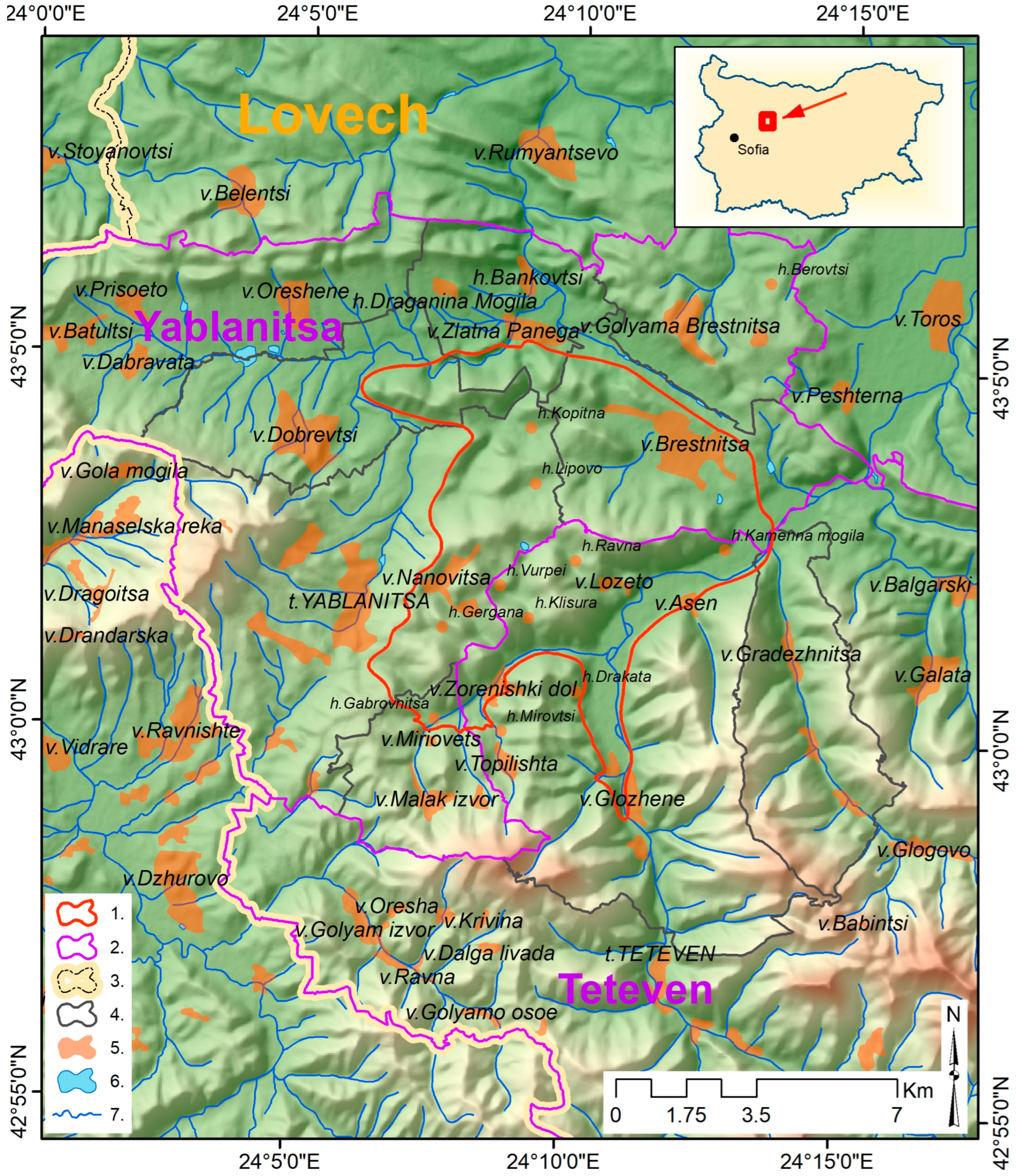
2. Object of This Study
- -
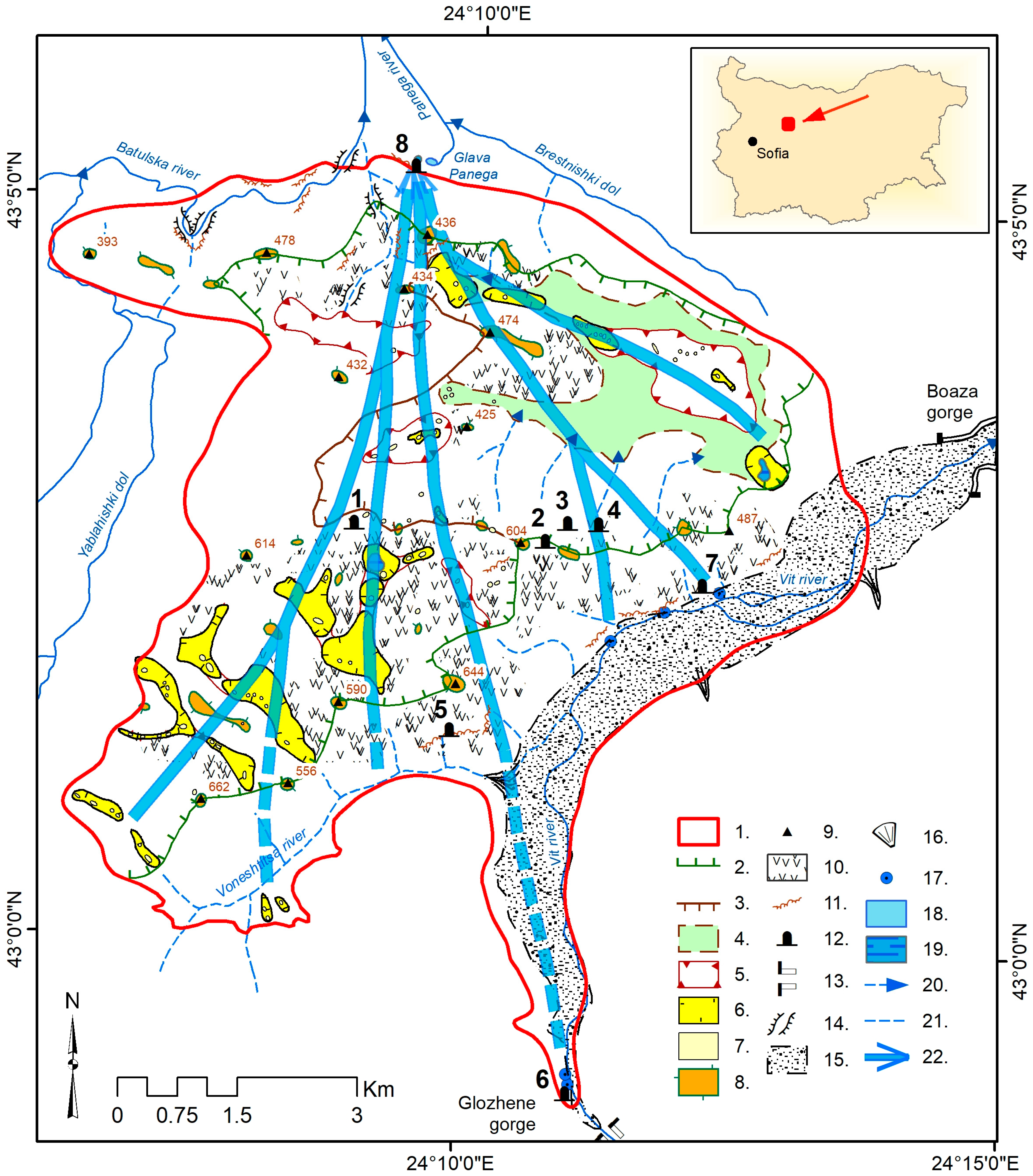
- Inflow of waters from the Vit river (direct and through the alluvial terrace) in the section between the gorges near the villages in the Glozhene and Boaza areas. Three sinkhole zones are located in the riverbed (Figure 2). The indicator experiments conducted in 1947 and 1955 prove that the sinking river waters, after 12 days, flow into the karst spring Glava Panega [23], which is the start of the Panega river, a right tributary of the Iskar river. The spring is of the Vauclusian type and its location is predetermined by the Brestnista fault in the contact zone of limestones with marls (sK1bs-b) [24]. Given that the straight-line distance between the sinkholes and the spring is approx. 7 km, this long period of underground flow is indicative of the complex underground karst subsystem. An assumption of a connection between the sinking waters of the Vit river and the Glava Panega spring was made as early as 1887 [28]. During the dry months at the end of summer and autumn, the river water completely sinks and the Vit river dries up.
- -
- Infiltration of rainwater through the entire exposed area of the limestones. An extensive non-drainage basin (36.544 km2) has been formed within the BKG, which covers 58.41% of the area of the geosystem.
3. Methods and Data
- -
- scientific research (main highlights: system analysis, integrated monitoring, and karst cadastre);
- -
- efficient and environmentally friendly management of the karst territories and business with karst resources;
- -
- innovative education and training for and through the karst, for which a specialized educational strategy, ProKARSTerra-Edu, has been developed.
- -
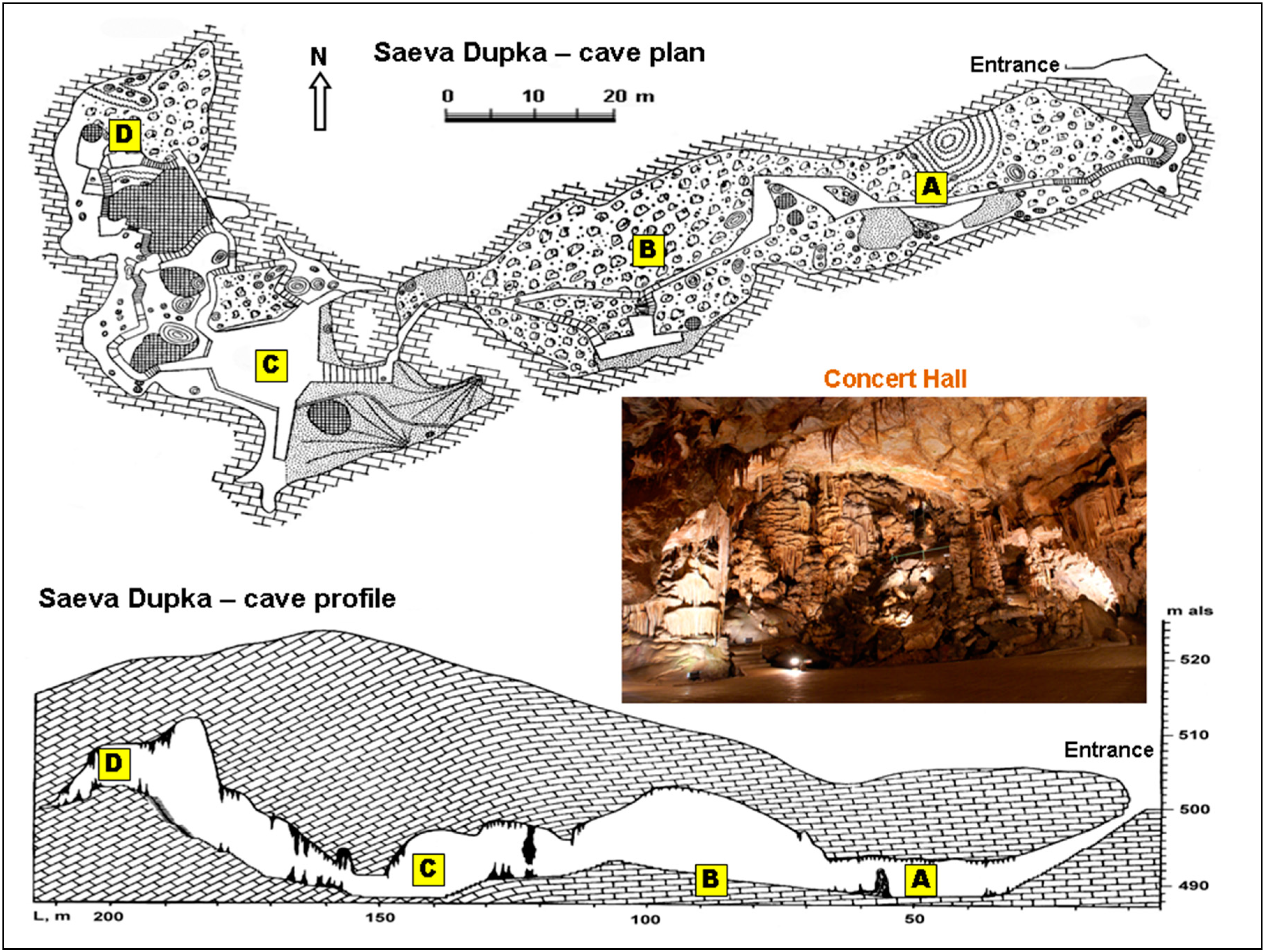
- Monitoring (hydrometric and hydrochemical) of the water cycle. This is achieved through expedition trips, which have been carried out once every 1–1.5 months since 2010. The objects of the monitoring are surface waters in the recharge zone (precipitation, soil, river, and swamps) and spring karst waters in the discharge zone. Karst groundwater in the transit zone (infiltration/droplet, condensation, cave ice, and cave lakes) is measured and sampled at seven representative points in Saeva Dupka cave. Due to the specificity of the karst waters and the instability of the carbonate balance, the hydrochemical analyses of the water samples are performed “in situ” in the cave and at its entrance with an MP-type field laboratory [35]. This methodology is also used in the analyses of the waters of the Vit river (at the sinkholes), of the Nanovitsa karst swamp, of the soil waters above Saeva Dupka cave, and at Glava Panega spring. If contamination is suspected, water samples are taken and analyzed in certified laboratories. Lysimeters are constructed to collect soil water and are installed in 2 soil horizons of the Rendzic Leptosol. Simplified versions of condensatometers that collect condensation water have been installed at 2 points in Saeva Dupka. Due to problems with their protection from contamination (dust from visitors and splashes from dripping cave water), the aggressiveness of condensation water, which has an important and still neglected role in speleogenesis, is determined in the cave experimentally [10]. Precipitation (rain and snow) in the area of Saeva Dupka is subject to periodic (seasonal) monitoring. It is collected outdoors under the shrub-tree vegetation and is analyzed “in situ”.
- -
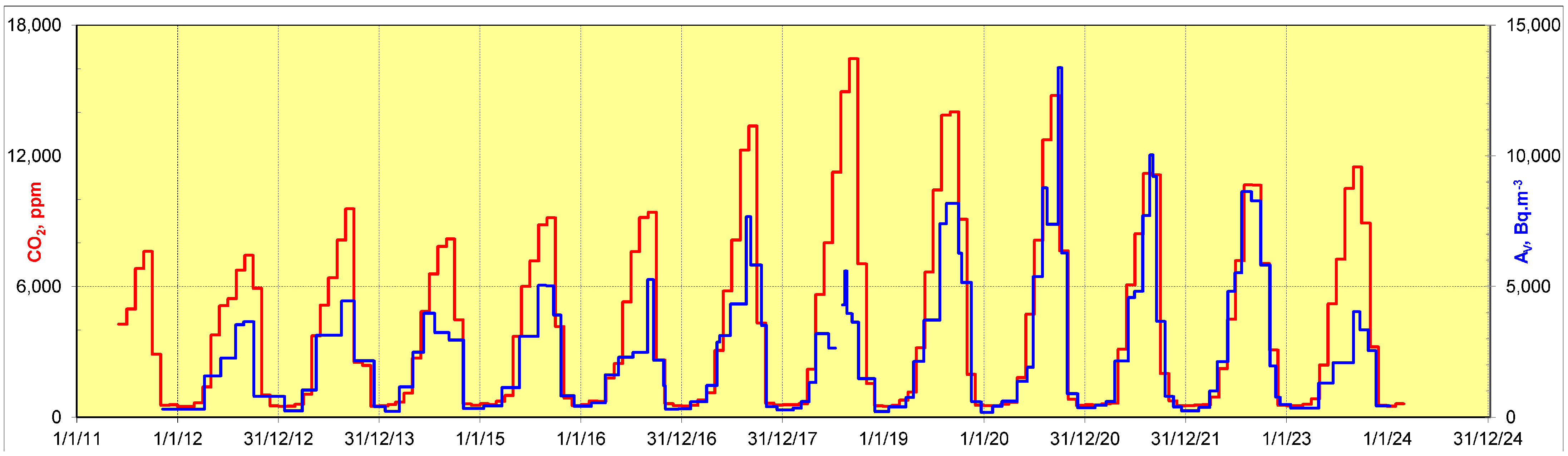
- Carbon cycle monitoring (CO2 concentration, ppm). This covers atmospheric air, soil air (above Saeva Dupka cave), and cave air (along the longitudinal profile of Saeva Dupka cave), as well as the content of free CO2 in the waters of the water cycle. Measurements of CO2 in the air are taken through expedition trips with a periodicity of 1–1.5 months and are carried out with a VAISALA Hand-Held carbon dioxide meter GM70. Since 2011 in the Concert hall and since 2018 in the Stack hall of Saeva Dupka cave, continuous instrumental monitoring of CO2 has been carried out with GMP222 probes with a range of 1–10,000 ppm. Free CO2 in the waters is determined by “in situ” titration using the field hydrochemical laboratory mentioned above.
- -
- Meteorological measurements. They are located above the entrance to Saeva Dupka cave. They have been carried out since 2017 with the VAISALA WTW520 automatic weather station with a measurement frequency of 10 min. Precipitation data are supplemented by data from a standard rain gauge installed in 2010 in the village of Brestnitsa. Available data from the National Institute of Meteorology and Hydrology’s Lovech weather station are also used.
- -
- Speleometeorological measurements (temperature and relative humidity of cave air, temperatures of cave waters and sediments, and atmospheric pressure). They are carried out during expedition trips at 14 points along the longitudinal profile of Saeva Dupka cave with portable instruments (Assman’s aspiration psychrometer with an accuracy of 0.1–0.2 °C and electronic thermometers with metal probes with an accuracy of 0.1 °C). Periodic temperature measurements are carried out in the soil above Saeva Dupka cave. Since 2018, 2 automatic weather stations (WTW535 Weather Transmitter Series (VAISALA)) have been installed in the Stack and Concert cave halls.
- -
- Radiological monitoring (bulk activity/concentration of radon-222 and activity of radiocarbon, 14C). This is concentrated within the boundaries of the Saeva Dupka cave system and has 3 objectives: the role of natural radiation processes in the cave atmosphere; connection between radon activity and tectono-seismic activity; and radiation protection of visitors and workers in Saeva Dupka cave [15]. Radiological monitoring is carried out in partnership with the Department of Radiation Dosimetry, Nuclear Physics Institute—Czech Academy of Sciences.
- -
- Monitoring of current seismo-tectonic activity. The object of the monitoring is Saeva Dupka cave, which is a natural rock cavity developed in a fault zone and very suitable for this type of measurement. The monitoring is conducted with a TM-71 3D dilatometer installed in 2012 in an open tectonic crack in the Concert hall. Saeva Dupka cave is included in the international network EU TecNet [36].
- -
- Socio-economic monitoring (SEM). This is carried out according to an experimentally developed original methodology for karst territories. In the BKG, it comprises an inventory of the socio-economic infrastructure and monitoring of visitors in Saeva Dupka cave, which has been carried out with an automatic counter since 2019.
4. Results and Discussion
4.1. Stages in the Karstogenesis of the BKG
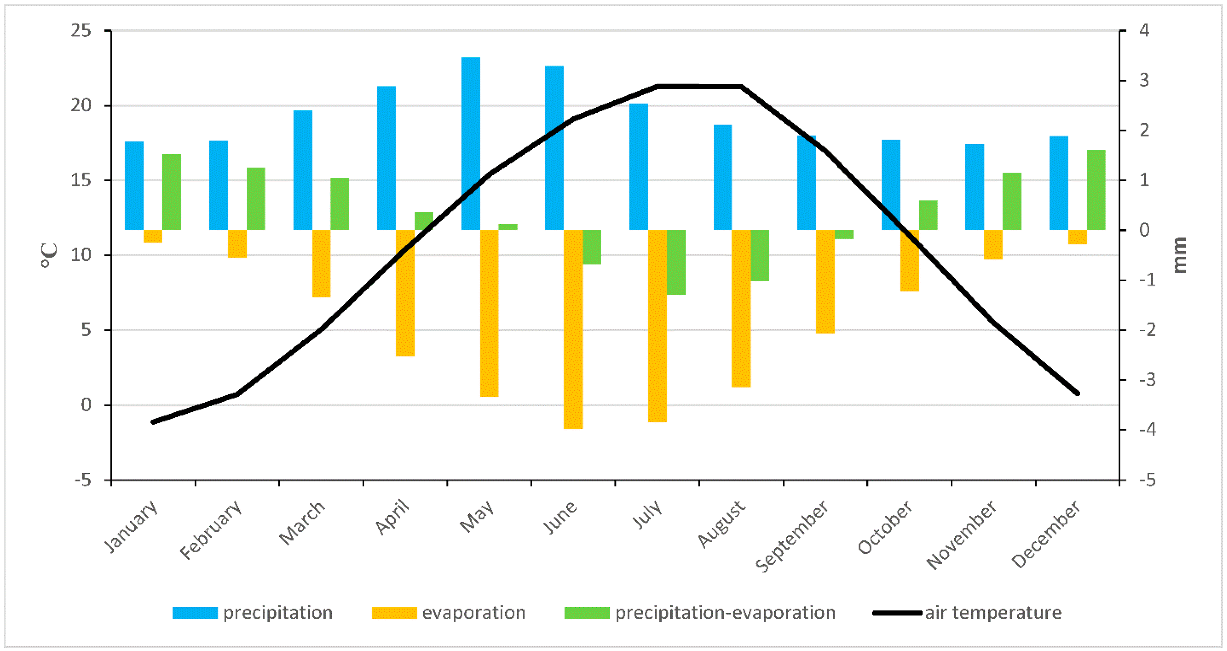
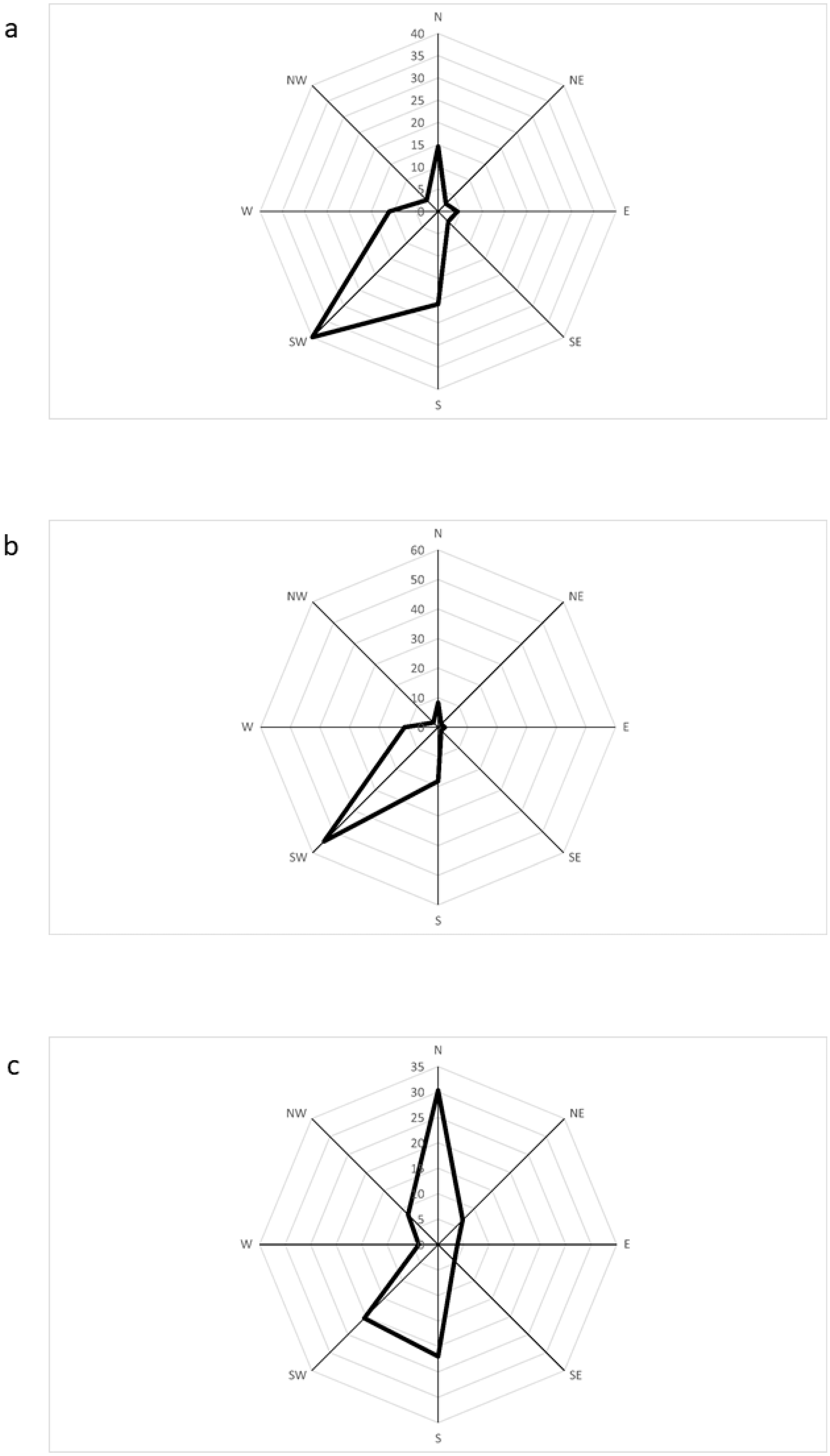
4.2. State and Trends in Current Climate Change in the BKG Region
4.2.1. Climate Change Affecting the Surface Subsystem of the BKG
4.2.2. Climate Change Affecting the Underground Subsystem of the BKG
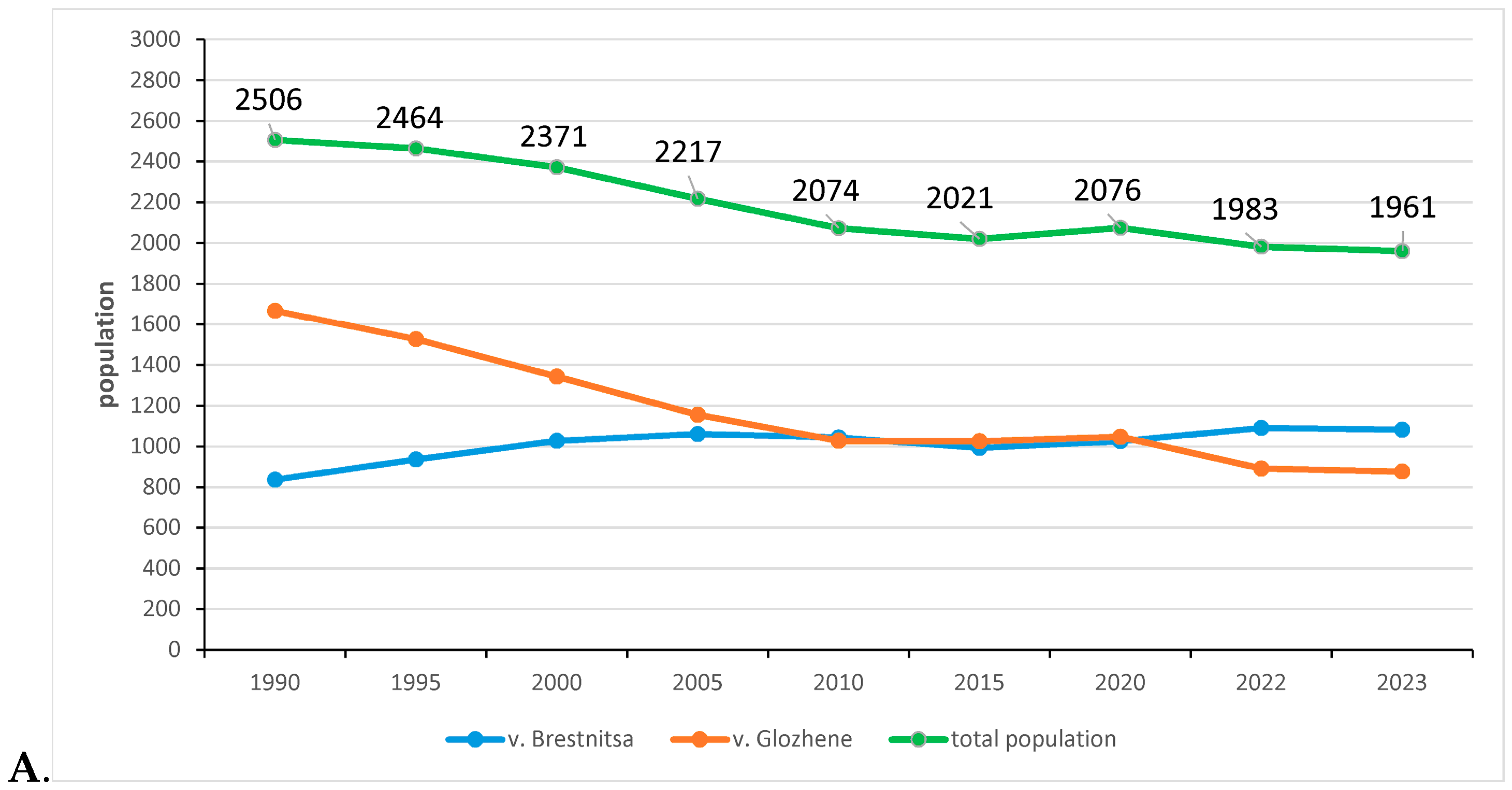
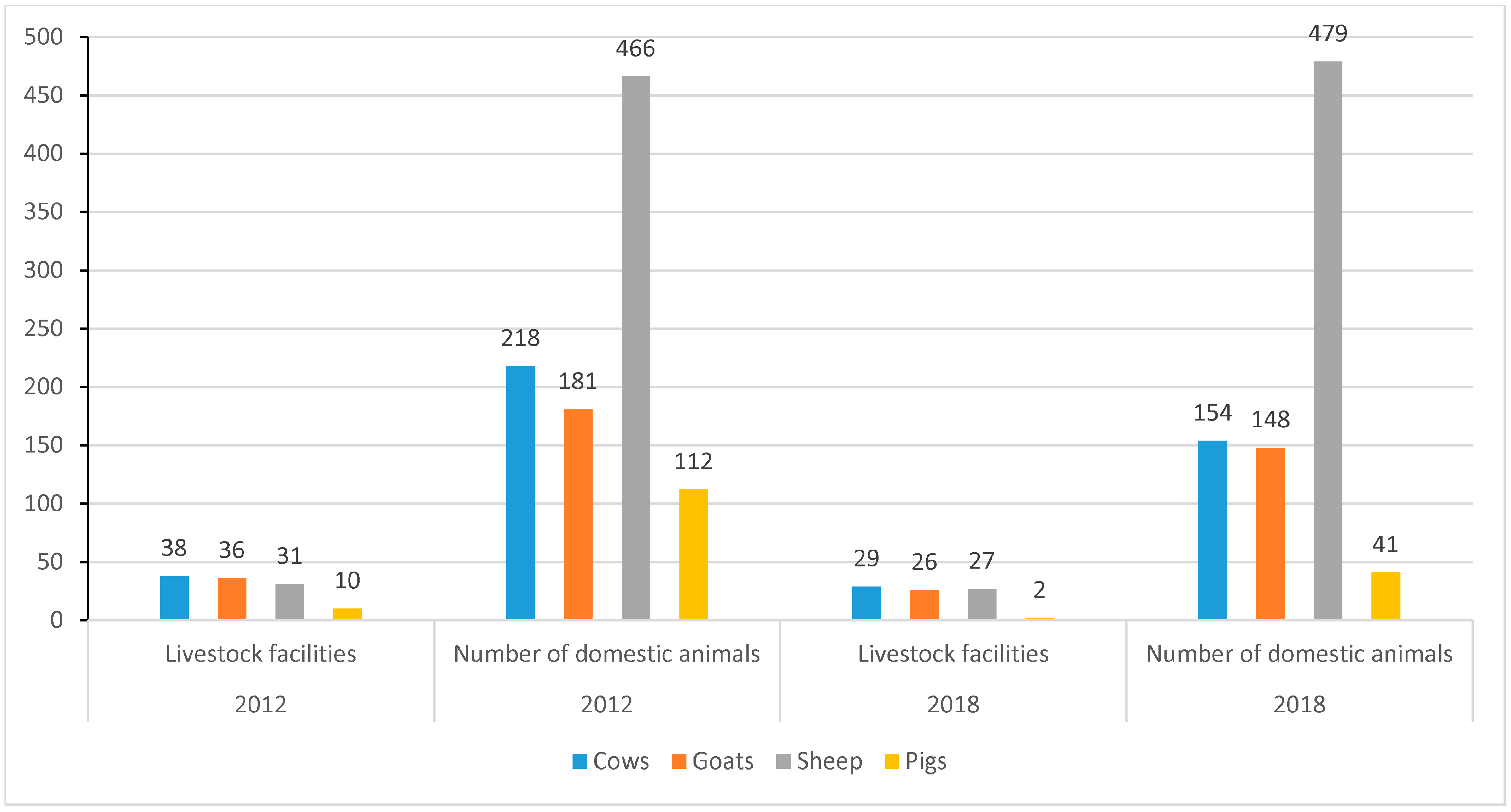
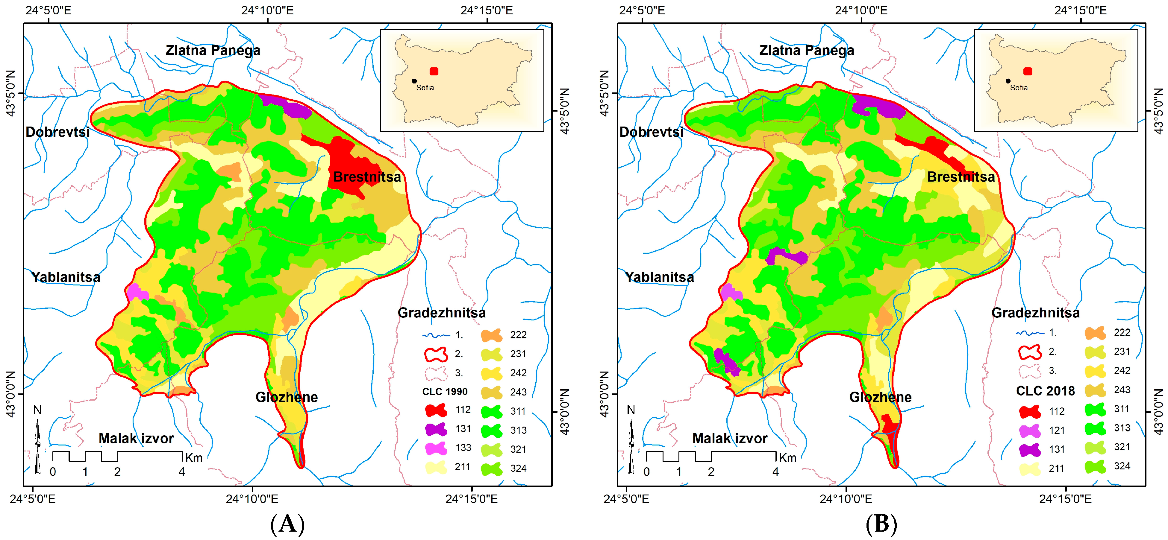
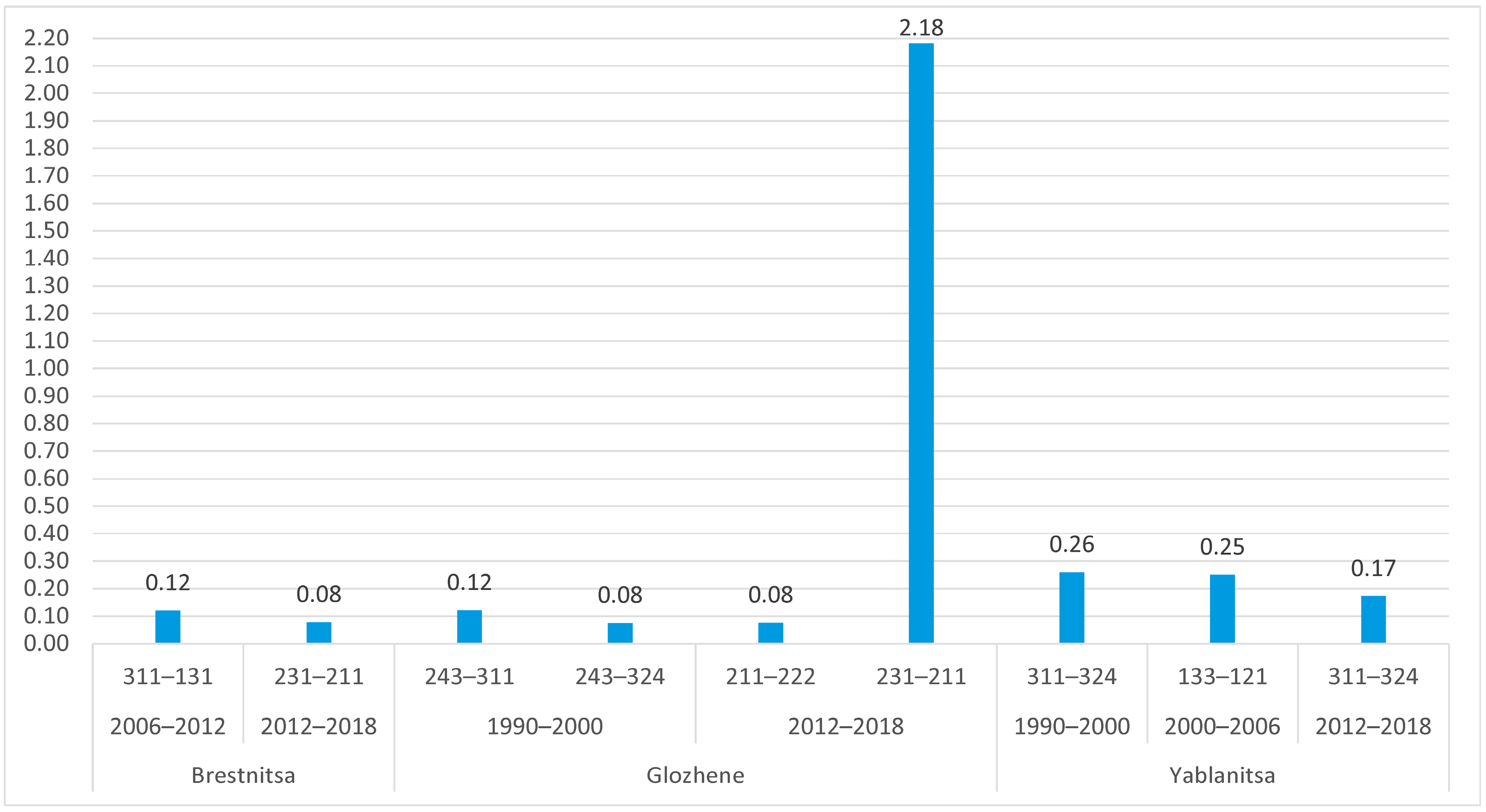
4.3. Anthropogenic Pressure and Changes in Land Use in the Territory of the Geosystem
- -
- conversion of deciduous forests into quarries (Figure 12). These changes are primarily related to the development of cement production. In recent years, there has already been a reversal process—reclamation of old quarries of the cement plant in the area of Glava Panega spring (planting of orchards). Another part of the old quarries is overgrown with shrub-tree vegetation and there is a process of restoring the soil layer.
- -
- transformation of broad-leaved forests into transitional tree-shrub vegetation as a result of felling (Figure 12);
- -
- transformation of pastures into arable lands (on the slopes of Brestnitsa karst polje and especially on the flood terraces of the river Vit) (Figure 12);
- -
- -
- Outdated and depreciated tourist infrastructure in the cave;
- -
- Widespread “lamp flora”—green “islands” of parasitic vegetation (lichens, mosses, and ferns) developing on the calcite forms, which are illuminated for a long time with “warm” spotlights;
- -
- Cases of vandalism in the cave—scratched and broken calcite forms;
- -
- Periodic pollution of the cave and the adjacent territory with waste thrown by tourists;
- -
- -
- Non-compliant with the karst specifics and outdated sanitary and hygienic facilities in the cave area: a fountain next to the office (fed by a cistern) without sewerage for wastewater and outdoor toilets with uninsulated septic tanks;
- -
- Auxiliary infrastructure inconsistent with the spatial location of the cave—the parking lot for Saeva Dupka cave and the external toilet serving it are located above the Cosmos hall of the cave.
- -
- drinking and domestic water supply (14 settlements from three municipalities, Yablanitsa, Lukovit, and Cherven Bryag, with a total population of over 34,000 people), carried out by Lovech Waterworks. The suction of the pumping station is discharged directly into the griffins between the Higher and Lower lakes. The water pipeline was built in 1984–1996. The authorized water use is 13,810 m3/d;
- -
- industrial water supply—“Zlatna Panega Cement” JSC (allowed water use is 11,233 m3/d);
- -
- water use for hygienic needs—laundry at the exit of Lower lake (allowed water use is 113.26 m3/d).
4.4. Expected Effects of the Revealed Trends in Global Changes on the Development of the Geosystem and Guidelines for Its Sustainable Development
5. Conclusions
Author Contributions
Funding
Institutional Review Board Statement
Informed Consent Statement
Data Availability Statement
Acknowledgments
Conflicts of Interest
References
- Nikolov, T. Global Changes of the Climates in Earth’s History; Prof. M. Drinov Academic Publishing House: Sofia, Bulgaria, 2011; 392p. (In Bulgarian) [Google Scholar]
- International Year of Caves and Karst. 2021. Available online: http://iyck2021.org (accessed on 20 January 2024).
- Brinkmann, R.; Parise, M. Karst environments: Problems, management, hauman impacts, and sustainability—An introduction to thae special issue. J. Cave Karst Stud. 2012, 74, 135–136. [Google Scholar] [CrossRef]
- van Beynen, P.; Brinkman, R.; van Beynen, K. A sustainability index for the karst environments. J. Cave Karst Stud. 2012, 74, 221–234. [Google Scholar] [CrossRef]
- Huang, J.; Ge, Z.; Huang, Y.; Tang, X.; Shi, Z.; Lai, P.; Song, Z.; Hao, B.; Yang, H.; Ma, M. Climate change and ecological engineering jointly induced vegetation greening in global karst regions from 2001 to 2020. Plant Soil 2022, 475, 193–212. [Google Scholar] [CrossRef]
- Pla, C.; Cuezva, S.; Garcia-Anton, E.; Fernandez-Cortes, A.; Cañaveras, J.C.; Sanchez-Moral, S.; Benavente, D. Changes in the CO2 dynamics in near-surface cavities under a future warming scenario: Factors and evidence from the field and experimental findings. Sci. Total Environ. 2016, 565, 1151–1164. [Google Scholar] [CrossRef] [PubMed]
- Pla, C.; Fernandez-Cortes, A.; Cuezva, S.; Galiana-Merino, J.J.; Cañaveras, J.C.; Sanchez-Moral, S.; Benavente, D. Insights on Climate-Driven Fluctuations of Cave 222-Rn and CO2 Concentrations Using Statistical and Wavelet Analyses. Geofluids 2020, 2020, 8858295. [Google Scholar] [CrossRef]
- Stefanova, D.; Stefanov, P. Socio-economic problems in vulnerable karst territories (case study of Brestnitsa karst area). SocioBrains 2021, 78, 322–342. (In Bulgarian) [Google Scholar]
- Sochava, V.B. Introduction to the Doctrine of Geosystems; Nauka: Novosibirsk, Russia, 1978; 318p. (In Russian) [Google Scholar]
- Armand, A.D. (Ed.) Stability of Geosystems; Institute of Geography of the Academy of Sciences; Nauka Publishing House: Moscow, Russia, 1983; 89p. (In Russian) [Google Scholar]
- Andreychouk, V. The system nature of karst landscape and principles of protection resulting from it. Z. Fűr Geomorphol. 2016, 60 (Suppl. 2), 257–291. [Google Scholar] [CrossRef]
- Andreychouk, V.; Stefanov, P. Some methodological remarks concerning of karst studies from the system approach perspective. Probl. Geogr. 2021, 1, 12–24. (In Bulgarian) [Google Scholar] [CrossRef]
- Preobrazhensky, V.S. Problems of Studying the Stability of Geosystems. In Stability of Geosystems; Nauka Publishing House: Moscow, Russia, 1983; pp. 4–7. (In Russian) [Google Scholar]
- LaMoreaux, P.E.; Powell, W.J.; LeGrande, H.E. Environmental and legal aspects of karst areas. Environ. Geol. 1997, 29, 23–36. [Google Scholar] [CrossRef]
- Stefanov, P. Integrated monitoring of the Saeva Dupka cave system (Speleo-MIKS “Saeva Dupka”). Probl. Geogr. 2020, 4, 3–40. (In Bulgarian) [Google Scholar] [CrossRef]
- James, E.W.; Banner, J.L.; Hardt, B. A global model for cave ventilation and seasonal bias in speleothem paleoclimate records. Geochem. Geophys. Geosystems 2015, 16, 1044–1051. [Google Scholar] [CrossRef]
- Spotl, C.; Fairchild, I.J.; Tooth, A.F. Cave air control on dripwater geochemistry, Obir Caves (Austria): Implications for speleothem deposition in dynamically ventilated caves. Geochim. Cosmochim. Acta 2005, 69, 2451–2468. [Google Scholar] [CrossRef]
- Riechelmann, D.F.C.; Schroder-Ritzrau, A.; Scholz, D.; Fohlmeister, J.; Spötl, C.; Richter, D.K.; Mangini, A. Monitoring Bunker Cave (NW Germany): A prerequisite to interpret geochemical proxy data of speleothems from this site. J. Hydrol. 2011, 409, 682–695. [Google Scholar] [CrossRef]
- Czuppon, G.; Demény, A.; Leél-Őssy, S.; Óvari, M.; Molnár, M.; Stieber, J.; Kiss, K.; Kármán, K.; Surányi, G.; Haszpra, L. Cave monitoring in the Béke and Baradla caves (Northeastern Hungary): Implications for the conditions for the formation cave carbonates. Int. J. Speleol. 2018, 47, 13–28. [Google Scholar] [CrossRef]
- Popov, V. Karst morphosculpture. In Geography of Bulgaria; Edition of “ForKom”: Sofia, Bulgaria, 2002; pp. 63–65. (In Bulgarian) [Google Scholar]
- Popov, V. Morphology of the karst in the area between the valleys of the rivers Vit and Batulska. J. Bulg. Geogr. Soc. 1962, 3, 21–33. (In Bulgarian) [Google Scholar]
- Experimental Laboratory of Karstology at NIGG-BAS—Methodology. Available online: http://www.prokarstterra.bas.bg/lab/methodology.html (accessed on 23 April 2024).
- Kovachev, I. Karst and Ground Karst waters in the Valley of Upper and Middle Vit and Glava Panega. In Karst Ground Waters in Bulgaria; Yaranov, D., Ed.; “Technika” Publishing House: Sofia, Bulgaria, 1959; pp. 183–229. (In Bulgarian) [Google Scholar]
- Tsankov, T.Z.; Nedyalkova, L.; Aladjova-Khrischeva, K.; Chrischev, C.; Angelova, D. Explanatory Supplement to the Geological Map of Bulgaria M 1:100 000, Map Sheet Cherven Bryag; Committee of Geoglogy and Mineral Resources, “Geology and Geophysics” Ltd.: Sofia, Bulgaria, 1994; 87p. (In Bulgarian) [Google Scholar]
- Alexiev, G. Morphostructural analysis. The Pre-Balkan block escarpment. In Geography of Bulgaria; Edition of “ForKom”: Sofia, Bulgaria, 2002; p. 86. (In Bulgarian) [Google Scholar]
- Gočev, P. The Teteven anticlinorium. In Tectonics of the Fore-Balkan; Bonchev, E., Ed.; Publishing House of the BAS: Sofia, Bulgaria, 1971; pp. 229–332. (In Bulgarian) [Google Scholar]
- The UIS Cave and Karst Glossary. Available online: http://uisic.uis-speleo.org/uisglossary-en.html (accessed on 16 April 2024).
- Shkorpil, H.; Shkorpil, K. Natural Resources of Bulgaria: Karst Phenomena (Underground Rivers, Caves, Springs); Publishing House of the bookstore “Pchela”: Plovdiv, Bulgaria, 1900; 55p. (In Bulgarian) [Google Scholar]
- Galabov, M.; Gergov, G.; Damyanov, A.; Kovachev, S. Groundwater transfer from the Vit river to the Iskar river through the karst reservoir “Zlatna Panega”. Rev. Bulg. Geol. Soc. 2000, 1–3, 151–156. (In Bulgarian) [Google Scholar]
- Penchev, P.; Velichkov, V. Project for Construction, Approval and Operation of a Sanitary Protection Zone around Glava Panega Karst Spring; Bulgarian Groundwater Association: Sofia, Bulgaria, 2012. (In Bulgarian) [Google Scholar]
- Jakucs, L. Morphogenetics of Karst Regions; Hilger: Bristol, UK, 1977; 284p. [Google Scholar]
- Zhalov, A. Glava Panega—The Longest Karst Spring in Bulgaria; Bulgarian Caves; Bulgarian Federation of Speleology: Sofia, Bulgaria, 1999; Volume 6, pp. 29–30. [Google Scholar]
- Stefanov, Y.; Radulov, A. Geological-Geochemical and Geophysical Characteristics of Rocks in the “Zlatna Panega” Quarry with the Aim of Clarifying the Geological Setting; Report on the Contract with Zlatna Panega Cement AD; 2020; 17p. [Google Scholar]
- Popov, V. Saeva Dupka [Cave]; “Medicine and Physical culture” Publishing House: Sofia, Bulgaria, 1969; 36p. (In Bulgarian) [Google Scholar]
- Markowicz, M.; Pulina, M. Ilosciowa Polmikroanaliza Chemiczna Wod w Obszarach Krasu Weglanowego; Universytet Slaski: Katowice, Poland, 1979; 67p. (In Poland) [Google Scholar]
- Monitorovací Síť TM-71—Evropa. Available online: https://www.tecnet.cz/index.php?page=google_mapa&map=4 (accessed on 23 April 2024).
- Copernicus Climate Change Service (C3S). ERA5: Fifth Generation of ECMWF Atmospheric Reanalyses of the Global Climate. Copernicus Climate Change Service Climate Data Store (CDS). 2017. Available online: https://cds.climate.copernicus.eu/cdsapp#!/home (accessed on 15 February 2024).
- Wilks, D.S. Statistical Methods in the Atmospheric Sciences; Second Edition (International Geophysics); Elsevier: Amsterdam, The Netherlands; Academic Press: Cambridge, MA, USA, 2006; Volume 91, 627p. [Google Scholar]
- Corine, Land Cover (CLC) for 1990, 2000, 206, 2012, 2018 and Land Cover Changes (LCC) 1990–2000, 2000–2006, 2006–2012, 2012–2018. Available online: https://land.copernicus.eu/pan-european/corine-land-cover (accessed on 1 March 2024).
- Alexiev, G. Relief. Quaternary river terraces. In Geography of Bulgaria; Edition of “ForKom”: Sofia, Bulgaria, 2002; pp. 55–57. (In Bulgarian) [Google Scholar]
- Nojarov, P. Strengthening of the maritime influence on the Balkans in summer as a result of changes in atmospheric circulation. Clim. Dyn. 2023, 60, 3225–3239. [Google Scholar] [CrossRef]
- Nojarov, P.; Stefanov, P.; Turek, K. Influence of some climatic elements on radon concentration in Saeva Dupka Cave, Bulgaria. Int. J. Speleol. 2020, 49, 235–248. [Google Scholar] [CrossRef]
- Stefanova, D.; Stefanov, P.; Jelev, G. Changes in land coverage and land use in selected model karst areas of Bulgaria. Probl. Geogr. 2020, 3, 157–186. (In Bulgarian) [Google Scholar] [CrossRef]
- Marinov, H. Conditions for the formation of the industrial centers of Pleven, Dolna Mitropolia, Dolni Dabnik, Cherven Bryag and Zlatna Panega and their gravitational potential. Bull. Geogr. Inst. BAS 1969, XII, 125–152. (In Bulgarian) [Google Scholar]
- Faimon, J.; Štelcl, J.; Sas, D. Anthropogenic CO2-flux into cave atmosphere and its environmental impact: A case study in the Císařská Cave (Moravian Karst, Czech Republic). Sci. Total Environ. 2006, 369, 231–245. [Google Scholar] [CrossRef] [PubMed]
- de Freitas, C.R. The role and importance of cave microclimate in the sustainable use and management of show caves. Acta Carsologica 2010, 39, 477–489. [Google Scholar] [CrossRef]
- Lang, M.; Faimon, J.; Pracny, P.; Kejíková, S. A show cave management: Anthropogenic CO2 in atmosphere of V’ypustek Cave (Moravian Karst, Czech Republic). J. Nat. Conserv. 2017, 35, 40–52. [Google Scholar] [CrossRef]
- Guirado, E.; Ramos-López, D.; Maldonado, A.D.; Moreno-Balcázar, J.J.; Calaforra, J.M. Modeling carbon dioxide for show cave conservation. J. Nat. Conserv. 2019, 49, 76–84. [Google Scholar] [CrossRef]
- Yamada, R.; Tamakuma, Y.; Suzuki, T.; Nakasone, S.; Shiroma, Y.; Furukawa, M.; Hashimoto, H.; Hosoda, M.; Akata, N.; Tokonami, S.A. Preliminary Study of Radon Equilibrium Factor at a Tourist Cave in Okinawa, Japan. Atmosphere 2021, 12, 1648. [Google Scholar] [CrossRef]
- Velev, S. Climatic regions. In Geography of Bulgaria; Edition of “ForKom”: Sofia, Bulgaria, 2002; pp. 155–156. (In Bulgarian) [Google Scholar]
- Stefanov, P.; Stefanova, D.; Turek, K. Microclimatic and radiation conditions and human health risks in show caves in Bulgaria (based on the results of integrated monitoring). Probl. Geogr. 2020, 3, 47–100. [Google Scholar] [CrossRef]
- de Freitas, C.R.; Schmekal, A. Condensation as a microclimate process: Measurement, numerical simulation and prediction in the Glowworm Cave, New Zealand. Int. J. Climatol. 2003, 23, 557–575. [Google Scholar] [CrossRef]
- Dublyansky, V.N.; Dublyansky, Y.V. The role of condensation in karst hydrogeology and speleogenesis. In Speleogenesis: Evolution of Karst Aquifers; Klimchouk, A., Ford, D., Palmer, A., Dreybrodt, W., Eds.; National Speleological Society: Huntsville, AL, USA, 2000; pp. 100–111. [Google Scholar]
- Dreybrodt, W.; Gabrovsek, F.; Perne, M. Condensation corrosion: A theoretical approach. Acta Carsologica 2005, 34, 317–348. [Google Scholar] [CrossRef]
- Briestenský, M.; Rowberry, M.D.; Stemberk, J.; Stefanov, P.; Vozár, J.; Šebela, S.; Petro, Ľ.; Bella, P.; Gaal, P.; Ormukov, C. Evidence of a plate-wide tectonic pressure pulse provided by extensometric monitoring in the Balkan Mountains (Bulgaria). Geol. Carpathica 2015, 66, 427–438. [Google Scholar] [CrossRef]
- Shilegarska, E.; Toleva, T.; Petkov, P.; Pophristova, A. Karst Monitoring at Zlatna Panega Quarry. Probl. Geogr. 2020, 3, 145–156. [Google Scholar] [CrossRef]
- Constantin, S.; Mirea, I.C.; Petculescu, A.; Arghir, R.A.; Măntoiu, D.Ș.; Kenesz, M.; Robu, M.; Moldovan, O.T. Monitoring Human Impact in Show Caves. A Study of Four Romanian Caves. Sustainability 2021, 13, 1619. [Google Scholar] [CrossRef]


| Level 1 | Level 2 | Level 3 |
|---|---|---|
| 1 Artificial surfaces | 11 Urban fabric | 112 Discontinuous urban fabric |
| 12 Industrial, commercial, and transport units | 121 Industrial or commercial units | |
| 13 Mine, dump, and construction sites | 131 Mineral extraction sites | |
| 133 Construction sites | ||
| 2 Agricultural areas | 21 Arable land | 211 Non-irrigated arable land |
| 22 Permanent crops | 222 Fruit trees and berry plantations | |
| 23 Pastures | 231 Pastures | |
| 24 Heterogeneous agricultural areas | 242 Complex cultivation patterns | |
| 243 Land principally occupied by agriculture, with significant areas of natural vegetation | ||
| 3 Forest and semi natural areas | 31 Forests | 311 Broad-leaved forest |
| 313 Mixed forest | ||
| 32 Scrub and/or herbaceous vegetation associations | 321 Natural grasslands | |
| 324 Transitional woodland–shrub |
| January | February | March | April | May | June | July | August | September | October | November | December | Annual | |
|---|---|---|---|---|---|---|---|---|---|---|---|---|---|
| Air temperature outside (°C) | 0.0279 | 0.078 | 0.0297 | 0.0328 | 0.0340 | 0.0371 | 0.0606 | 0.073 | 0.0246 | 0.0114 | 0.077 | 0.0373 | 0.0436 |
| Precipitation (mm) | 0.0152 | 0.0107 | 0.0116 | −0.00519 | −0.01889 | −0.000829 | −0.00994 | −0.03106 | 0.0168 | 0.0246 | −0.01860 | 0.00295 | −0.000228 |
| Evaporation (mm) | −0.001809 | −0.00641 | −0.00662 | −0.00746 | −0.00955 | −0.006761 | −0.004109 | −0.00006 | 0.0089 | 0.00013 | −0.002486 | −0.001100 | −0.003112 |
| Precipitation–evaporation (mm) | 0.0134 | 0.00425 | 0.00501 | −0.01265 | −0.02845 | −0.00759 | −0.01405 | −0.03112 | 0.0257 | 0.0247 | −0.02109 | 0.00185 | −0.003340 |
| Specific humidity (kg*kg−1) | 0.000005 | 0.000017 | 0.000002 | 0.000005 | 0.000005 | 0.000021 | 0.000018 | 0.000011 | −0.000008 | 0.000006 | 0.000026 | 0.000009 | 0.000010 |
| Year | 1 Artificial Surfaces | 2 Agricultural Areas | 3 Forest and Semi-Natural Areas |
|---|---|---|---|
| 1990 | 4.9 | 48.8 | 46.4 |
| 2000 | 4.9 | 48.5 | 46.7 |
| 2006 | 4.5 | 49.4 | 46.1 |
| 2012 | 4.7 | 47.4 | 47.8 |
| 2018 | 4.7 | 47.4 | 47.8 |
| Year | Corine, Land Cover Level 3 | ||||||||||||
|---|---|---|---|---|---|---|---|---|---|---|---|---|---|
| 112 | 121 | 131 | 133 | 211 | 222 | 231 | 242 | 243 | 311 | 313 | 321 | 324 | |
| 1990 | 3.57 | 0.0 | 0.89 | 0.63 | 14.77 | 1.62 | 5.58 | 7.44 | 19.37 | 32.32 | 1.04 | 0.01 | 12.99 |
| 2000 | 3.57 | 0.0 | 0.89 | 0.63 | 14.77 | 1.62 | 5.58 | 7.44 | 19.05 | 32.10 | 1.04 | 0.01 | 13.53 |
| 2006 | 2.00 | 0.40 | 2.07 | 0 | 17.00 | 0.70 | 5.34 | 10.33 | 16.06 | 31.24 | 1.04 | 0.01 | 13.94 |
| 2012 | 2.00 | 0.40 | 2.33 | 0 | 8.21 | 0.70 | 15.14 | 9.61 | 13.74 | 30.98 | 1.04 | 0.01 | 15.95 |
| 2018 | 2.00 | 0.40 | 2.33 | 0 | 11.40 | 0.70 | 11.74 | 9.61 | 13.95 | 30.83 | 1.04 | 0.01 | 16.10 |
| Parameters | Concert Hall—CO2 | |
|---|---|---|
| Warm (V–VIII) | Cold (XII–III) | |
| Air temperature outside (°C) | −0.10 | 0.49 |
| Precipitation (mm) | −0.04 | 0.05 |
| Evaporation (mm) | −0.48 | −0.39 |
| Specific humidity (kg*kg−1) | 0.44 | 0.51 |
Disclaimer/Publisher’s Note: The statements, opinions and data contained in all publications are solely those of the individual author(s) and contributor(s) and not of MDPI and/or the editor(s). MDPI and/or the editor(s) disclaim responsibility for any injury to people or property resulting from any ideas, methods, instructions or products referred to in the content. |
© 2024 by the authors. Licensee MDPI, Basel, Switzerland. This article is an open access article distributed under the terms and conditions of the Creative Commons Attribution (CC BY) license (https://creativecommons.org/licenses/by/4.0/).
Share and Cite
Nojarov, P.; Stefanov, P.; Stefanova, D.; Jelev, G. Climate Change, Anthropogenic Pressure, and Sustainable Development of Karst Geosystems (A Case Study of the Brestnitsa Karst Geosystem in Northern Bulgaria). Sustainability 2024, 16, 6657. https://doi.org/10.3390/su16156657
Nojarov P, Stefanov P, Stefanova D, Jelev G. Climate Change, Anthropogenic Pressure, and Sustainable Development of Karst Geosystems (A Case Study of the Brestnitsa Karst Geosystem in Northern Bulgaria). Sustainability. 2024; 16(15):6657. https://doi.org/10.3390/su16156657
Chicago/Turabian StyleNojarov, Peter, Petar Stefanov, Dilyana Stefanova, and Georgi Jelev. 2024. "Climate Change, Anthropogenic Pressure, and Sustainable Development of Karst Geosystems (A Case Study of the Brestnitsa Karst Geosystem in Northern Bulgaria)" Sustainability 16, no. 15: 6657. https://doi.org/10.3390/su16156657
APA StyleNojarov, P., Stefanov, P., Stefanova, D., & Jelev, G. (2024). Climate Change, Anthropogenic Pressure, and Sustainable Development of Karst Geosystems (A Case Study of the Brestnitsa Karst Geosystem in Northern Bulgaria). Sustainability, 16(15), 6657. https://doi.org/10.3390/su16156657