Article

A Multi-Objective Optimization Approach for Solar Farm Site Selection: Case Study in Maputo, Mozambique

1
Department of Physical Geography and Ecosystem Science, Lund University, S-223 62 Lund, Sweden
2
Department of Mathematics and Informatics, Faculty of Science, Eduardo Mondlane University, Maputo 257, Mozambique
*
Author to whom correspondence should be addressed.
Sustainability 2024, 16(17), 7333; https://doi.org/10.3390/su16177333
Submission received: 15 April 2024 / Revised: 2 July 2024 / Accepted: 22 July 2024 / Published: 26 August 2024

Abstract

:
Solar energy is an important source of clean energy to combat climate change issues that motivate the establishment of solar farms. Establishing solar farms has been considered a proper alternative for energy production in countries like Mozambique, which need reliable and clean sources of energy for sustainable development. However, selecting proper sites for creating solar farms is a function of various economic, environmental, and technical criteria, which are usually conflicting with each other. This makes solar farm site selection a complex spatial problem that requires adapting proper techniques to solve it. In this study, we proposed a multi-objective optimization (MOO) approach for site selection of solar farms in Mozambique, by optimizing six objective functions using an improved NSGA-II (Non-dominated Sorting Genetic Algorithm II) algorithm. The MOO model is demonstrated by implementing a case study in KaMavota district, Maputo city, Mozambique. The improved NSGA-II algorithm displays a better performance in comparison to standard NSGA-II. The study also demonstrated how decision-makers can select optimum solutions, based on their preferences, despite trade-offs existing between all objective functions, which support the decision-making.

1. Introduction

Renewable energy has played an increasingly pivotal role in combating climate change [1] due to its minimal greenhouse gas emissions compared to fossil fuels [2]. Solar energy, a significant player among renewables, is crucial for meeting climate goals outlined in agreements like the Paris Agreement [3]. With the global population rising rapidly, energy demand is also soaring. Solar energy shows the enormous potential to satisfy global energy needs, provided the accessible technology for capture and distribution [4]. The installed capacity of solar photovoltaic (PV) systems has surged from 40,344 to 709,674 megawatts between 2010 and 2020. Consequently, establishing solar farms has become an appealing strategy for transitioning to renewable energy amidst energy crises and climate change concerns.
Mozambique has significant untapped potential in renewable energy resources, but several challenges hinder the ability of the country to fully utilize them. Challenges and opportunities comprise energy access and quality, electricity access rate, high energy costs, and legislative framework [5,6]. Therefore, ensuring energy access, advancing the deployment of renewable energy, and enhancing the regulatory framework are essential for Mozambique’s economic growth, social development, and environmental preservation. Investment in infrastructure, technology, and capacity building, as well as strategic partnerships with the private sector and international organizations, could help unlock the full potential of renewable energy in the country. In recent years, Mozambique has explored the potential in hydropower, solar energy, wind energy, biomass, and bioenergy to address its energy needs and promote sustainable development [7]. In particular, solar farms have played a vital role in extending electricity access to underserved communities.
Solar farms, also known as solar power plants or solar PV farms, are large-scale installations that harness solar energy to generate electricity. These farms consist of arrays of solar panels or modules mounted on support structures, such as ground-mounted racks. Solar farms can vary in size, from small community installations to utility-scale facilities covering hundreds of acres. As technology advances and costs decrease, solar farms are anticipated to become an increasingly significant part of the global energy landscape. However, one of the main challenges for creating solar farms is to determine their optimal locations. This is because different criteria, usually conflicting with each other, need to be considered and satisfied for the selection of the proper site. For example, while a high level of solar radiation and low slope may be two important criteria for a proper site, areas with abundant solar radiation may be in inclined areas. A number of studies have utilized multi-criteria decision analysis (MCDA) [8,9,10] to solve solar farm site selection problems, while the research on using MOO is still limited [11,12].
MOO, as a mathematical and computational approach, has been widely used to find solutions that simultaneously optimize multiple conflicting objectives or criteria in addressing complex problems [13,14]. Unlike single-objective optimization aiming to find a single best solution, MOO seeks to identify a set of solutions known as the Pareto front. In this set, no solution is universally better than the others across all objectives, but each solution is superior in at least one objective compared to the rest [15]. It enables decision-makers to examine the trade-offs between conflicting objectives and make informed decisions based on their preferences and priorities [16]. Since the site selection of solar farms is a complex decision-making process that requires the consideration of various criteria, MOO is particularly valuable in addressing such real-world problems with multiple stakeholders and diverse criteria for success. By incorporating various stakeholders’ preferences, MOO ensures that the chosen sites resonate with the community. This narrative intertwines economic prosperity with environmental stewardship and social responsibility, creating trade-off solutions. Therefore, the research on employing multi-objective optimization in the site selection of solar farms could provide valuable insights for decision-makers and contribute to the sustainable development of solar energy infrastructure.
In this study, we aim to develop a spatial MOO approach for the site selection of solar farms, which seeks a trade-off solution between solar radiation, distance to the electricity grid, and other urban environment and topographic factors. In particular, the standard NSGA-II algorithm is improved and used to solve the MOO problem [13]. To our knowledge, the research on applying the NSGA-II for the site selection of solar farms is still scarce. The approach is implemented based on a case study in KaMavota district, Maputo City, Mozambique.

2. Literature Review

Numerous studies have explored site selection for solar farms, employing various methodologies and focusing on different geographical regions. For instance, Yousefi et al. conducted research on identifying suitable sites for solar power plants in Markazi Province of Iran by integrating fuzzy and Boolean logic with GIS analysis [17]. Similarly, Uyan [18] investigated the site selection for solar farms in Turkey with GIS and Analytic Hierarchy Process (AHP) methods by considering factors like terrain quality, weather patterns, and environmental concerns to aid decision-makers in optimizing investments and minimizing environmental impacts. Chiarani et al. [19] conducted a study in Brazil, employing MCDA to assess the viability of different regions for concentrated solar power (CSP) plants. Their research integrated GIS and AHP to prioritize potential sites based on expert judgments and weighted criteria, producing viability indices that indicated suitable regions for CSP development. Additionally, in Turkey’s Malatya Province, Colak et al. [20] utilized GIS technology and the AHP method to identify optimal locations for solar power plants. Another study employed GIS technology to identify optimal locations for solar power plants in the Ayranci region in Karaman, Turkey [21]. Various factors were taken into account in these studies, including solar energy potential, topography, economic and environmental conditions, and so on.
Several studies have explored the use of multi-objective optimization for selecting sites for solar farms and tackled the complexities of balancing environmental, social, and economic factors [22]. For example, Kazemi et al. [22] expanded the focus by including social aspects in their solar farm site selection process. Their holistic decision-making framework considered criteria such as biodiversity conservation, community acceptance, and job creation, alongside traditional factors like solar irradiance and land availability. Through MOO techniques, they identified optimal sites across this multidimensional landscape using a genetic algorithm. These studies collectively highlight the benefits of a multidimensional approach to solar energy infrastructure development, integrating environmental, social, and economic considerations to promote sustainable energy development and societal well-being.
Overall, GIS data were frequently employed to account for spatial variations in resource availability. In addition, these studies highlight the importance of employing diverse methodologies and considering multiple factors, including technical, economic, and environmental aspects, to support decision-making in site selection for solar power plants across geographical regions. In particular, GIS-based methods such as the AHP, MCDA, fuzzy logic, and Boolean logic have been widely used. The research on the site selection of solar farms with MOO is still limited, especially in the context of Mozambique.

3. Materials and Methods

3.1. Study Area and Data Preparation

Mozambique is situated in southeastern Africa, with the Indian Ocean to the east. It shares borders with Tanzania to the north, Malawi and Zambia to the northwest, Zimbabwe to the west, and Eswatini (formerly Swaziland) and South Africa to the southwest. The country has a diverse geography, including coastal plains along the Indian Ocean, plateaus and highlands in the interior, and mountains along the border with Zimbabwe. The capital city of Mozambique is Maputo, located along the coast in the southern part of the country. Our study is carried out in KaMavota district, which is located in the Maputo Province of Mozambique. It is an administrative subdivision of the capital city, Maputo, as shown in Figure 1.
KaMavota District, situated in the northeastern part of Maputo, spans across 63.32 km2. It is an area marked by rapid urbanization and demographic growth. Various facilities can be observed in the map below, including educational institutions ranging from kindergartens to secondary schools, government residences, police stations, farms, small-scale industries, commercial establishments, hotels, healthcare facilities, and grocery stores. It boasts a harmonious blend of residential and commercial properties, making it a dynamic and vibrant locale.
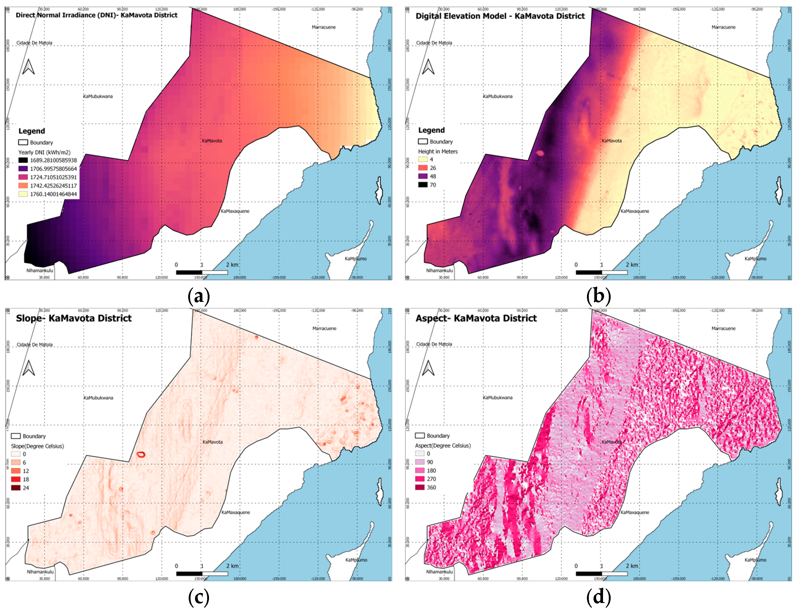
The following spatial datasets were collected for the study. Note that the data must be provided at a consistent resolution to ensure accuracy in the site selection analysis. After data preprocessing, the corresponding maps were produced with a spatial resolution of 30 m (Figure 2). All the areas such as lakes, rivers, and protected areas that cannot potentially be a proper site for establishing solar farms were masked and stored in a layer. These masked polygons will be excluded from the search space at the time of optimization. In addition, the datasets in vector format such as road networks or power lines were projected and converted to raster format with the same spatial resolution.
Solar Radiation: The data were extracted from a satellite-generated model created by the Global Solar Atlas, depicting a map of Direct Normal Irradiance (DNI) within the research area. DNI quantifies the solar radiation absorbed from direct sunlight at a specific spot and holds significance in solar power systems [23]. DNI serves as a critical factor in the realm of solar energy, notably for systems dependent on focused sunlight. Regions with elevated DNI levels are prime locations for constructing solar energy facilities due to their heightened energy concentration, resulting in increased energy generation.
Topographic: Topographic information is crucial in evaluating the landscape features, shadowing, and changes in elevation that can impact the positioning of solar panels and electricity production. Key topographic datasets utilized for this research include:
  • Digital Elevation Models (DEMs): Detailed elevation data of the Earth’s surface at a resolution of about 30 m.
  • Slope and Aspect Maps: Information on the steepness (slope) and orientation (aspect) of the land, extracted from the DEM data as shown in Figure 2c,d.
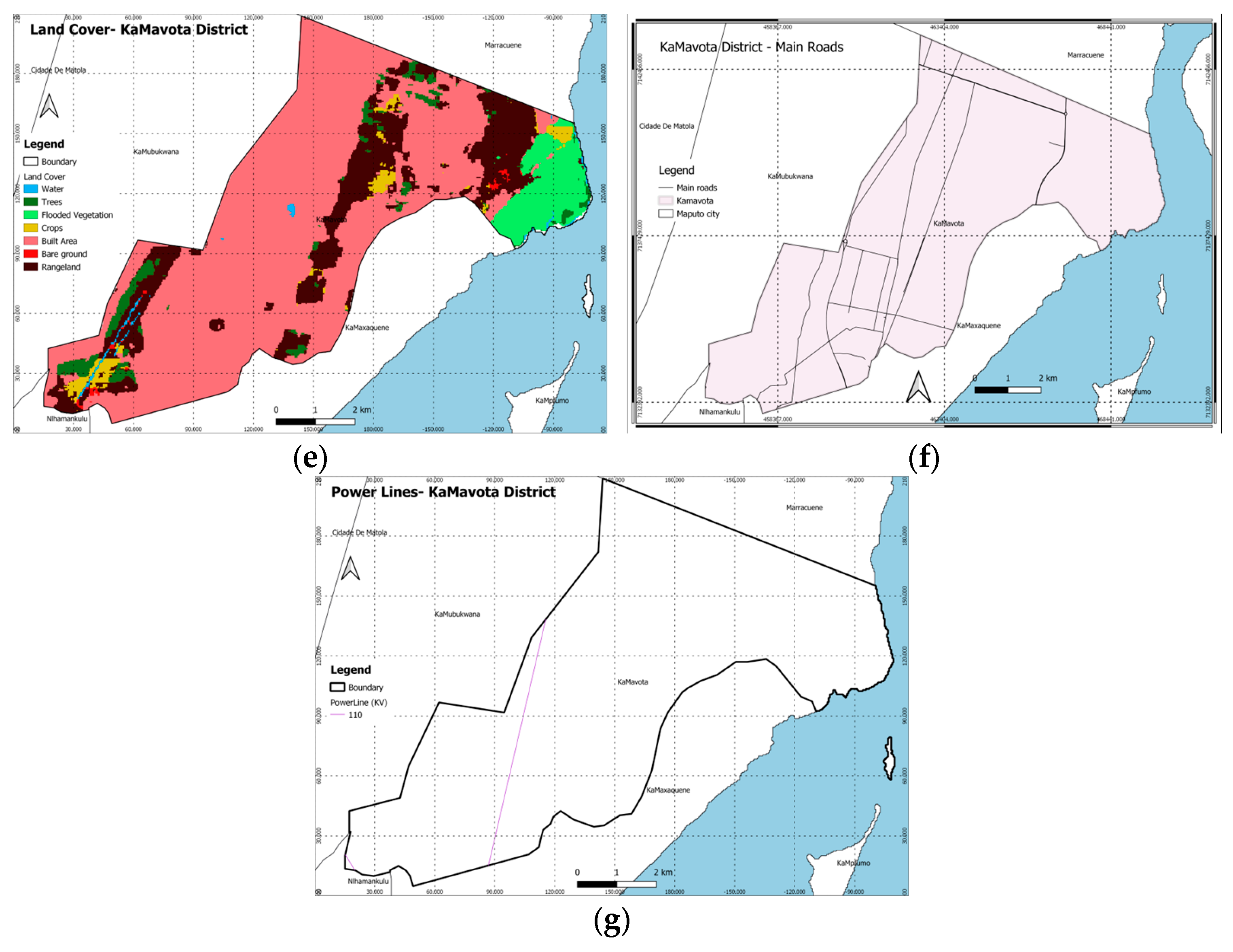
Land Use and Land Cover: Land utilization and land cover play a crucial role in pinpointing appropriate land areas for solar installations and evaluating potential land use conflicts. In Maputo, there are seven categories of land use, including water bodies, forests, flooded vegetation, crops, built-up areas, bare ground, and rangelands, as illustrated in Figure 2e.
Electricity and Infrastructures: This dataset includes medium- and high-voltage transmission lines in Mozambique, provided by the World Bank in a vector data format (Figure 2g). The dataset is used in this study to estimate the accessibility and cost of connection of solar farms to the electrical grid.
Environmental Constraints: This dataset includes information about environmentally sensitive areas, wildlife habitats, water bodies, and regulatory restrictions that are inhibited for any construction (Figure 2e). This dataset was received from [24].
Road Network: It includes transportation infrastructure (Figure 2f). Proximity or accessibility to roads is crucial to facilitate the construction and maintenance of solar farms. The dataset was collected from OpenStreetMap [25].

3.2. Methodology

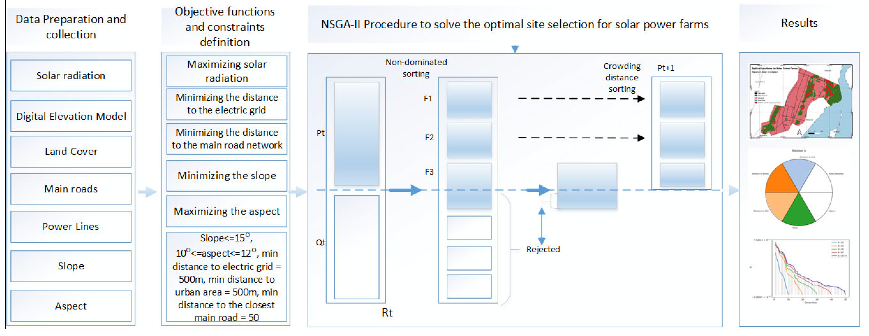
Figure 3 presents the flow diagram for the methodology with the following steps. First, the related factors are calculated based on the collected and preprocessed datasets in Section 3.1. Second, a MOO model is developed to optimize the site selection of solar farms by defining the objective functions and constraints, which is elaborated in Section 3.2.1. Third, NSGA-II is modified and improved to solve the MOO model, which is introduced in Section 3.2.2.

3.2.1. Multi-Objective Optimization Model

In this paper, the MOO model is formulated based on six conflicting objectives, including total solar radiation, total distance from solar farm to electricity grid, total distance from solar farm to road network, total distance from solar farm to urban area, total slope, and total aspect. The developed multi-objective optimization model seeks to select the most proper location for establishing solar farms where maximum solar radiation exists and distances to the electrical grid, roads, and urban areas are minimal, while slope and aspect values are minimal too. These objectives will contribute to establishing solar farms in areas where energy production is efficient and costs associated to construction, maintenance, and connection to the electricity grid are minimum (e.g., construction on a flat area is less expensive than construction on an inclined area). Environmental criteria are also taken into account by considering land cover/use type and protected areas in the site selection process. To achieve these, the following objective functions were defined mathematically.
  • Maximizing the solar radiation
The amount of solar radiation is a key factor in determining the efficiency and output of a solar farm. Maximizing solar radiation in the site selection for solar power farms is essential for optimizing energy production, increasing revenue potential, enhancing cost-effectiveness, promoting energy security and reliability, and realizing environmental benefits. It forms the foundation for the successful operation and long-term viability of solar energy projects.
Let R n × m be the set of grid cells with n rows and m columns that receive solar irradiation over Maputo, and E R n × m be a set of cells that irradiate over a photovoltaic power plant. Let f 1 : E R be the objective function defining the total amount of direct solar radiation used in the photovoltaic power plant, x E ,   x = x i j n × m ,   a n d   x i j is the amount of direct solar radiation over the i t h   a n d   j t h cell with the photovoltaic power plant. If the i t h   a n d   j t h cell does not contain a photovoltaic power plant then, the value of x i j is equal to zero. The total amount of direct solar irradiation is,
f 1 x = m a x i = 1 n j = 1 m x i j .
where f 1 is measured in kilowatt-hour per square meter (kWh/m2).
2.
Minimizing the distance to the electric grid
Closeness to electricity grids reduces the cost of connecting the solar farm plant to the electricity network. So, this objective function also deals with economic factors. Minimizing the distance to the electric grid in the site selection for solar farms is essential for reducing transmission losses, lowering infrastructure costs, enhancing grid stability, expediting project implementation, and improving energy access. It optimizes the integration of solar energy into the existing electricity grid, maximizing the benefits of renewable energy deployment.
Let E 1 R n × m be a set consisting of all suitable locations for solar energy sites, and x i j α E 1 be the suitable location for solar energy site α . Let E 2 R n × m be a set of the electric grid in Maputo, and x k l β 1 E 2 be the (potential) connecting point to the grid β 1 . E 1 E 2 = ϕ ,   E = E 1 E 2 . Let f 2 : E R be the objective function defining the total distance between suitable locations for solar farms and electric grid lines, and d 1 is the minimum distance between the electric grid and the power solar plant. Then, the total distance function to the electric grid is defined as follows:
f 2 x = m i n i j k l x i j α x k l β 1 ,
where d 1 is the minimal distance allowed between the solar farms to the electric grid, x i j α x k l β 1 is the Euclidian distance between x i j α   a n d   x k l β 1 , and m i n x i j α x k l β 1 d 1 for all x i j α   a n d   a l l   x k l β 1 . f 2 is measured in meters (m).
3.
Minimizing the distance to road network
Accessibility is an important criterion for the site selection of a solar farm. We include it in the site selection as an objective function related to the closeness to major roads. Minimizing the distance to the main road network in the site selection for solar power farms is essential for ensuring ease of access, construction efficiency, emergency response capabilities, operational efficiency, cost savings, and positive community relations. It optimizes the logistics and management of solar power projects, contributing to their success and sustainability.
Let E 1 R n × m be a set consisting of all suitable locations for solar energy sites, and x i j α E 1 be the suitable location for solar energy site α . Let E 2 R n × m be a set of road networks in Maputo, and x k l β 2 E 2 be the connection point to the road system β 2 . E 1 E 2 = ϕ ,   E = E 1 E 2 . Let f 3 : E R be the objective function defining the total distance between suitable locations for solar energy and urban areas, and d 2 is the minimum distance between roads and the power solar plant. Then, the total distance function is defined as follows,
f 3 x = m i n i j k l x i j α x k l β 2 ,
where d 2 is the minimal distance allowed between the power solar farms to the closest road, x i j α x k l β 2 is the Euclidian distance between x i j α   a n d   x k l β 2 , and m i n x i j α x k l β 2 d 2 for all x i j α   a n d   a l l   x k l β 2 . f 3 is measured in meters (m).
4.
Minimizing distance to the urban area
Solar power plants may produce some noise (e.g., from inverters) and can have visual impacts [26]. At the other side, the closeness to urban areas reduces the transmission cost. Minimizing the distance to urban areas in the site selection for solar power farms maximizes energy demand proximity, facilitates grid integration, optimizes land use efficiency, stimulates economic development, promotes community engagement, and enhances environmental justice. It aligns with sustainable development goals while accelerating the transition to clean, renewable energy sources.
To achieve the objective, a buffer zone is created, where the solar farm should not be inside it (to resolve the noise and improper visual impacts), but the distance to the buffer should be minimized. Let E 1 R n × m be a set consisting of all suitable locations for solar energy sites, and x i j α E 1 be the suitable location for solar energy site α . Let E 2 R n × m be a set of all urban areas in Maputo, and x i j β 3 E 2 be the suitable location for solar energy site β 3 . E 1 E 2 = ϕ ,   E = E 1 E 2 . Let f 4 : E R be the objective function defining the total distance between suitable locations for solar farms and urban areas, and d 3 is the minimum distance between the residential area and the power solar plant. Then, the total distance function is defined as follows,
f 4 x = m i n i j k l x i j α x k l β 3
where d 3 is the minimal distance allowed between the power solar farm to the urban area (habitational infrastructures), x i j α x k l β 3 is the Euclidian distance between x i j α   a n d   x k l β 3 , and m i n x i j α x k l β 3 d 3 for all x i j α   a n d   a l l   x k l β 3 . f 4 is measured in meters (m).
5.
Minimizing the slope
A solar farm should be placed in a spot with very little shade and where panels can point toward receiving lots of sunlight. When thinking about this, it is essential to look at the Digital Elevation Model slope. Slope means how steep or slanted the land is in a certain spot. It is usually measured in degrees or as a percentage (rise over run). For picking spots for solar power plants, it is generally better to go with an area that is flat or has a low slope. This way, it is easier to put up solar panels and they receive more sunlight. But if the area has high slopes, then it can be harder to set up the panels and might need extra support structures. Steeper slopes can also affect how well the solar panels work since they may not receive direct sunlight for a large part of the day. Therefore, when choosing where to put solar power farms, minimizing the slope is key. It helps point the solar panels in the right direction, cuts down on shading, makes installation and upkeep easier, boosts safety and access, uses land more efficiently, and keeps things stable in the long run. This leads to making more energy, running things better, and lowering risks—all helping solar projects succeed and last long.
Let R n × m be the set of grid cells that cover the slope of Maputo, and E R n × m be a set of cells that contains a suitable land for a solar site. Let f 5 : E R be the objective function defining the total amount of slope used in the photovoltaic power plant, measured in degrees (°), x E ,   x = x i j n × m ,   a n d   x i j is the slope over the i t h   a n d   j t h cell with the photovoltaic power plant. If the i t h   a n d   j t h cell does not contain suitable land for a solar site, then, the value of x i j is equal to zero. The total amount of slope used to build all photovoltaic power plants is expressed as,
f 5 x = m i n i = 1 n j = 1 m x i j .
6.
Maximizing the aspect
Aspect refers to the compass direction that the slope faces. It is typically measured in degrees from north (e.g., 0° for north, 90° for east, 180° for south, and 270° for west) [27]. Aspect influences how much sunlight a location receives throughout the day. Solar panels are typically most efficient when facing south (in the Northern Hemisphere) or north (in the Southern Hemisphere) because they receive the most direct sunlight. A solar power plant’s aspect can be optimized by aligning the solar panels in a way that maximizes exposure to the sun. Maximizing the aspect objective in the site selection for solar power farms is essential for optimizing sunlight exposure, increasing energy production, reducing shading, accommodating seasonal variations, optimizing system design, and improving the economic viability of the project. It ensures that the solar power farm operates efficiently and effectively, maximizing its contribution to renewable energy generation.
Let R be a set of non-negative real numbers, n and m be sets of positive integer numbers. Let R n × m be the set of grid cells that cover the aspect over Maputo, and E R n × m be a set of cells that irradiate over a photovoltaic power plant. Let f 6 : E R be the objective function defining the total amount of the aspect, measured in degrees (°), x E ,   x = x i j n × m ,   a n d   x i j is the amount of direct solar radiation over the i t h   a n d   j t h cell for the solar energy site. If the i t h   a n d   j t h cell is not suitable for the solar energy sites, then, the value of x i j is equal to zero. The total amount of aspect is,
f 6 x = m a x i = 1 n j = 1 m x i j .
In the context of optimization problems, a constraint is a condition or restriction that must be satisfied in order to consider a solution as feasible. Constraints define boundaries or limitations within which the variables of the optimization problem must operate [28]. They can be expressed as equations or inequalities that the variables need to fulfill. Considering land cover classifications, we selected the rangeland as the pre-suitable land for solar farms. From the pre-suitable land, we selected cells whose slope is less than 15°. Therefore, we updated the pre-suitable land with the one that satisfies the slope constraint. From the updated pre-suitable land, we select cells that satisfy the aspect constraint, which means the aspect should be between 10° to 12° [29,30]. The minimal distance allowed between the power solar farms to the urban area is 500 m, the minimal distance allowed between the power solar farms to the closest road is 50 m, and the minimal distance allowed between the power solar farms to the electric grid is 500 m.
In summary, the multi-objective optimization model for selecting solar farm sites in Maputo, Mozambique. considers the economic, environmental, and technical criteria. Economic criteria cover the costs associated with connecting the solar farm to the existing power grid, ease of access to the site for construction, maintenance, and operational activities, in terms of the distance to electric grid, distance to road network, and distance to urban area. Minimizing these distances or costs enhances the project’s economic feasibility. Environmental criteria concentrate on solar irradiance, which is essential for maximizing energy production and selecting sites with the greatest potential for solar energy generation. Furthermore, land use and availability are assessed by examining the current land usage and its appropriateness for solar farm development. This is to prevent conflicts with agricultural, residential, or protected areas, and to ensure that the solar farms do not disturb existing environmental conditions and biodiversity. The aim is to minimize ecological disturbance and comply with environmental protection regulations. Technical criteria focus on site topography. Site topography is evaluated based on the slope and elevation of the land. Flatter areas are preferred for solar farm construction to decrease construction challenges and costs linked to uneven terrain.

3.2.2. NSGA-II

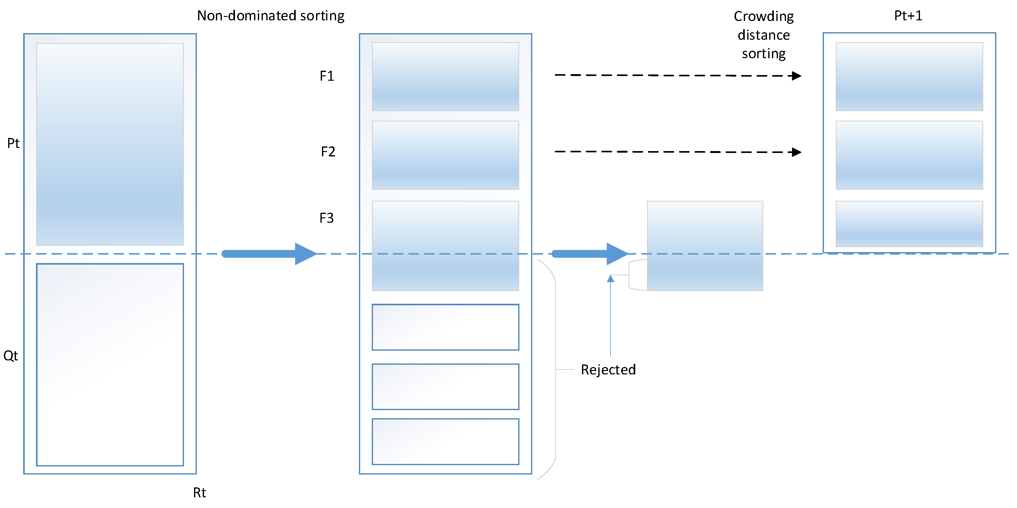
As shown in Figure 4, NSGA-II begins with a population of 2 N = P t Q t = R t candidate solutions adapted based on the mask, each representing a potential solution to the optimal allocation of solar farms problem space. These solutions undergo evolution through a series of iterative generations, each aimed at refining and improving the population. At the heart of NSGA-II lies the process of genetic operations—crossover and mutation. The crossover operator involves combining the genetic material of two parent solutions to create offspring, blending their traits in the hopes of generating offspring with superior characteristics. Meanwhile, mutation introduces random changes, injecting a dose of exploration into the gene pool, ensuring that novel solutions have the chance to emerge. Nevertheless, NSGA-II does not stop there; it possesses a keen eye for quality amidst the vast set of potential solutions. It employs a sorting mechanism inspired by Pareto dominance to categorize solutions into fronts F 1 , F 2 , F 3 , , where each front represents a level of non-dominance, as shown in Figure 4. Solutions occupying the first front are Pareto optimal—they cannot be improved in any objective without sacrificing performance in another. These elite solutions form the backbone of the evolving population, P t + 1 , driving it toward the frontier of optimal trade-offs.
Yet, NSGA-II’s quest for excellence extends beyond the confines of a single front. It nurtures diversity within the population, ensuring that a rich spectrum of solutions is preserved across multiple fronts. This diversity safeguards against premature convergence, allowing NSGA-II to explore the vast expanse of the solution space, uncovering hidden gems that might otherwise remain undiscovered. As the generations unfold, NSGA-II orchestrates a delicate dance between exploitation and exploration, honing in on promising regions of the solution space while maintaining a broad perspective to avoid getting trapped in local optima. With each passing iteration, the population evolves, converging toward a set of solutions that not only defy dominance but also embody the essence of efficiency, balance, and diversity. In the end, NSGA-II delivers not just solutions but insights—a roadmap to navigate the complex landscape of multi-objective optimization, guiding decision-makers toward a deeper understanding of trade-offs, preferences, and possibilities. Armed with NSGA-II, the journey toward optimal solutions becomes not just a quest but a revelation, illuminating the path toward a brighter, more efficient future.
However, NSGA-II also has some limitations. One significant limitation is scalability; when dealing with large objective spaces, the algorithm may struggle. It can have difficulty managing problems with numerous objective functions and constraints, potentially resulting in an excessive number of non-dominated solutions. This abundance can make it challenging to maintain diversity and achieve convergence. Another limitation is parameter sensitivity. The performance of NSGA-II is heavily influenced by the choice of operators, such as population initialization, crossover, and mutation operators. Finding the optimal settings for these operators can be time-consuming and may need to be tailored to the specific multi-objective optimization problem. Additionally, NSGA-II may be slow to converge to the Pareto front for complex problems, which is not ideal for real-world issues that require quick solutions. There is also the risk of stagnation, where the algorithm makes no significant progress over generations. Overall, these limitations affect the effectiveness of NSGA-II, particularly for more complex or large-scale problems. Overcoming these challenges often involves using advanced initialization techniques or adaptive multi-objective operators.
Improving NSGA-II involves implementing various strategies to overcome its limitations and enhance performance in tackling multi-objective optimization challenges. Enhancing NSGA-II includes utilizing advanced initialization techniques and adaptive multi-objective operators. The advanced initialization method leverages domain-specific expertise for optimal site selection for solar power farms, generating an initial population that is both diverse and representative of the solution space. Additionally, it incorporates a seeding strategy where certain initial solutions are derived from previous runs. The adaptive multi-objective operator involves the use of specialized crossover and mutation operators tailored for multi-objective optimization tasks, particularly in the site selection for solar power farms. This allows for more effective handling of diverse and conflicting objectives. Moreover, an operator selection mechanism is included to choose the most suitable genetic operators based on the current stage of the search process. By combining improvements to existing components with the integration of new techniques, optimizing NSGA-II becomes considerably more efficient. This enhancement makes NSGA-II particularly suitable for resolving complex multi-objective optimization problems, such as the optimal site selection for solar power farms in Maputo, Mozambique. The improved NSGA-II algorithm features adaptive mutation and crossover operators, along with better initialization techniques. It uses adaptive methods to adjust mutation and crossover rates dynamically during the optimization process. These adaptive operators balance exploring new solutions and improving existing ones, leading to overall better performance. Additionally, the process starts with a diverse and representative initial group of solutions, speeding up the optimization process and exploring the solution space more thoroughly.

4. Results

In this study, the Python library ‘pymoo’ was used for NSGA-II implementation. Pymoo provides a framework for solving multi-objective optimization problems. Pymoo is designed to be user-friendly, extensible, and efficient, making it suitable for researchers and practitioners working on MOO problems [31]. We used the Pygmo package to compute the hypervolume. Pygmo, which stands for Python Global Multi-objective Optimizer, is an open-source Python library for optimization and global optimization problems [32]. It is built on top of the Pagmo C++ library but provides a convenient Python interface. Pygmo is designed to facilitate the implementation, testing, and execution of optimization algorithms, especially those designed for MOO [33]. In this section, we present the Pareto optimal set, perform the variability analysis of the Pareto front set, and display the optimal solution maps.

4.1. Pareto Front Analysis

Pareto front analysis is a technique used in MOO to identify and analyze the trade-offs between conflicting objectives [34]. In the context of optimization problems with multiple objectives, the Pareto front represents the set of solutions that are not dominated by any other solution in all objectives. A solution is said to dominate another solution if it is equal to or better than the other solution in all objectives and strictly better in at least one objective. The goal is to find solutions that represent a trade-off between these objectives, as improving one objective may result in the deterioration of another. The Pareto front identifies those solutions that are not dominated by any other solution in the set, meaning there is no other solution that is better in all objectives [35].
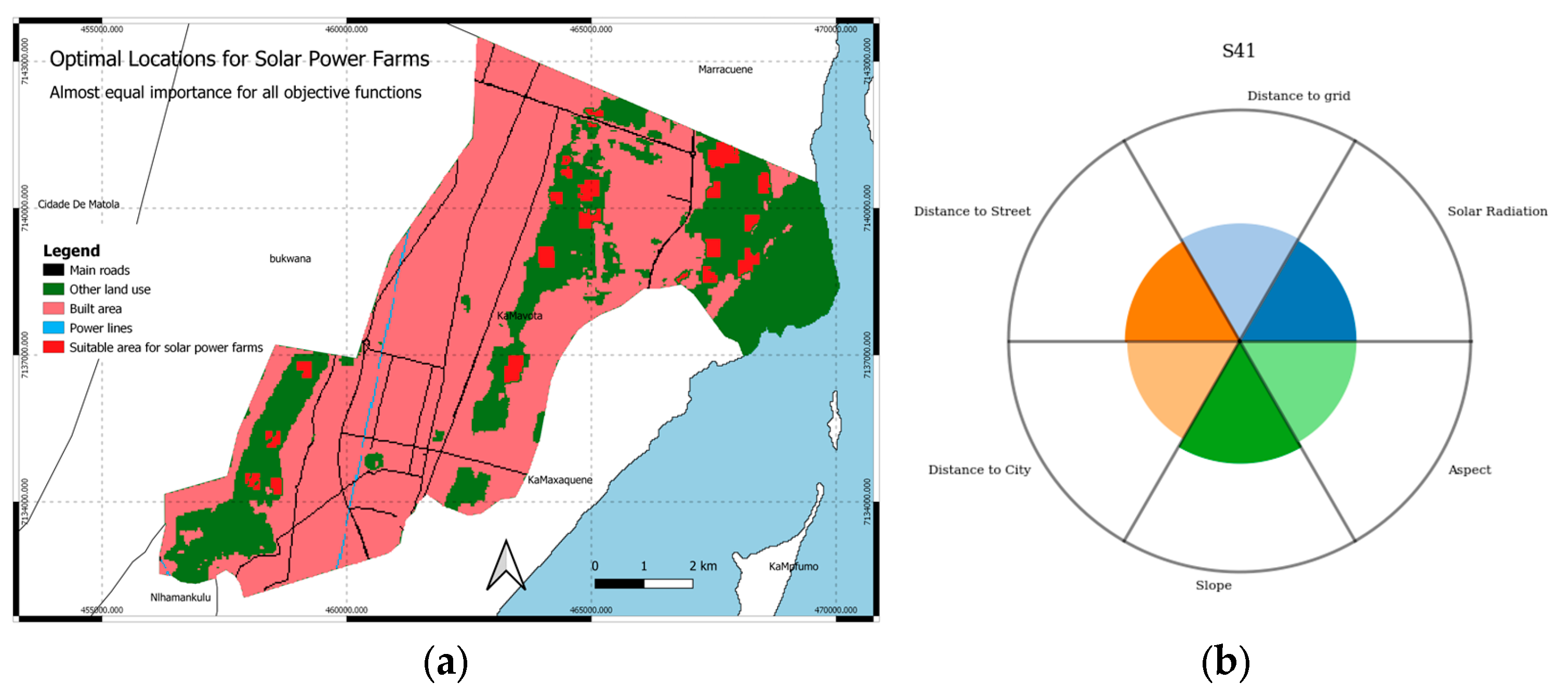
Figure 5 illustrates pie charts of optimal Pareto front solutions, known as Petal diagrams. These diagrams arrange objective function values in a circular sector manner, facilitating decision-making by allowing decision-makers to prioritize objectives according to their preferences [36]. For instance, if the highest priority for decision-makers is to maximize total solar radiation (f1), they might select the solution depicted in Figure 5(S3), which offers the best value for total solar radiation while still maintaining an optimal value for total aspect. Note that even if S1, S2, and S3 look the same, there are still tiny differences among them at a high resolution. On the other hand, if minimizing the three total distance-related objectives (f2, f3, f4) and total slope are the primary concerns, the solution shown in Figure 5(S4) might be preferred, as it gives the highest importance to these objectives, while there is still a trade-off among other objective functions. Solutions that provide similar preference across all objective functions can be identified, such as those represented in Figure 5(S41), which allocates nearly equal importance to each objective function. This solution might be suitable when decision-makers have balanced priorities across all objectives.
Decision-makers should consider various factors when selecting sites for solar power farms because not all locations are equal in terms of solar potential, environmental impact, land use, and economic viability. Decision-makers should have different preferences in the site selection for solar power farms to balance various factors such as solar potential, environmental impact, land use, economic viability, infrastructure, and community engagement. By considering these diverse criteria, they can identify optimal sites that maximize energy generation while minimizing environmental and social risks.
There are 50 solutions because the population size of NSGA-II is equal to 50. However, the number of solutions generated by NSGA-II depends on various factors including the parameters of the algorithm (e.g., population size, number of generations), the complexity of the problem being optimized, and the characteristics of the Pareto front. The user can specify parameters such as population size, crossover rate, mutation rate, and termination criteria. The algorithm then iteratively evolves a population of candidate solutions over multiple generations, maintaining diversity and convergence toward the Pareto front. The final number of solutions produced by NSGA-II can vary significantly based on these parameters and the nature of the optimization problem. It is common for NSGA-II to produce a population of solutions that adequately represents the trade-offs between conflicting objectives, but there is not a fixed number of solutions generated by the algorithm.

4.2. Variability Analysis

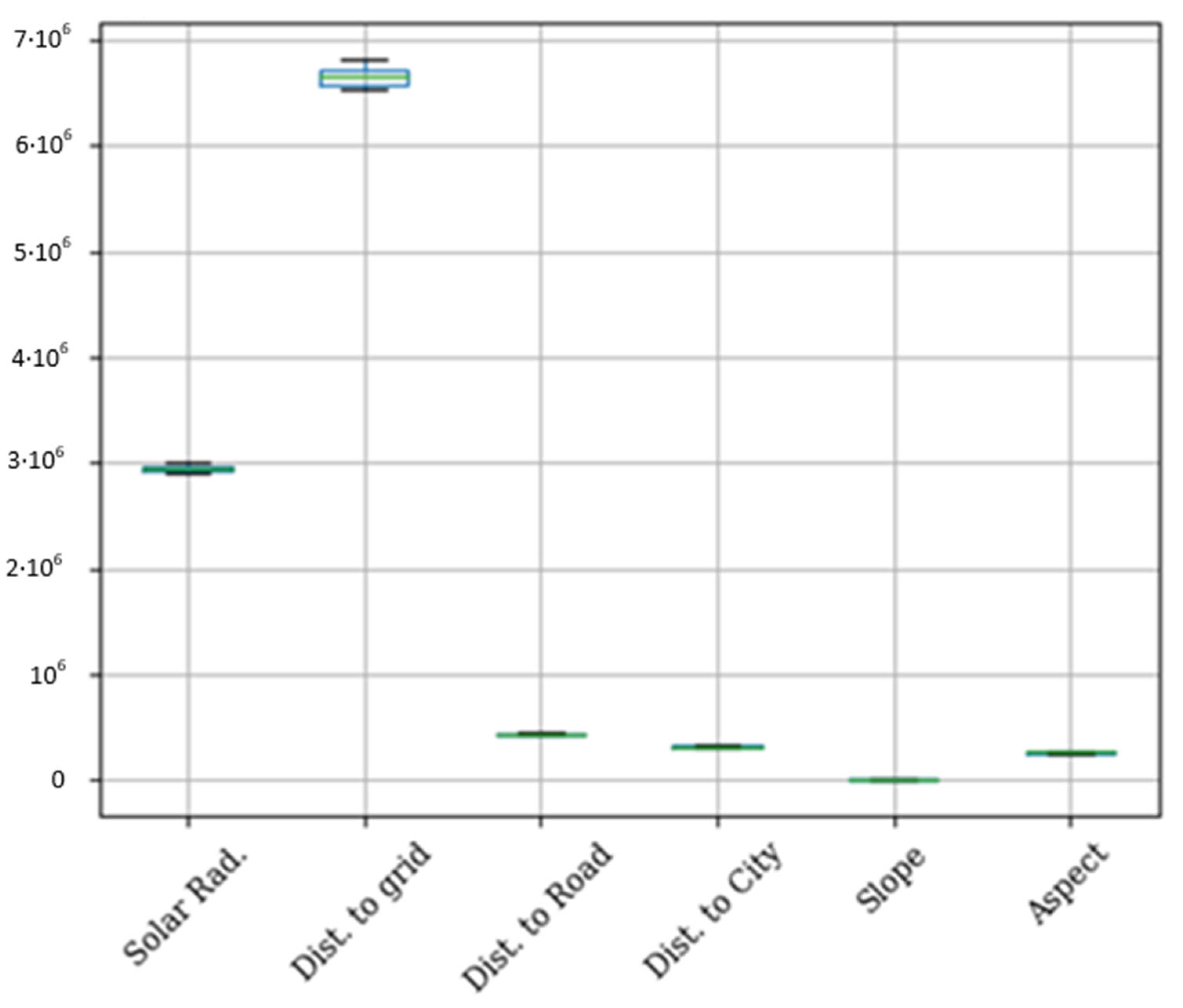
Variability analysis involves studying and understanding the extent of variation in a set of data or a system [37]. This type of analysis is employed in various fields, including statistics, quality control, manufacturing, and scientific research, to assess and characterize the dispersion or spread of data points. Figure 6 presents the visual boxplots that represent the distribution and variability of the optimal Pareto front set. The box represents the interquartile range, and the whiskers extend to the minimum and maximum values of the objective functions. According to the boxplot, the variability of each objective is very low. It implies the objective functions of the total distance to grid with high variability and the total slope with the lowest variability. But, in general, we can say that the optimal Pareto front set has a low variability.
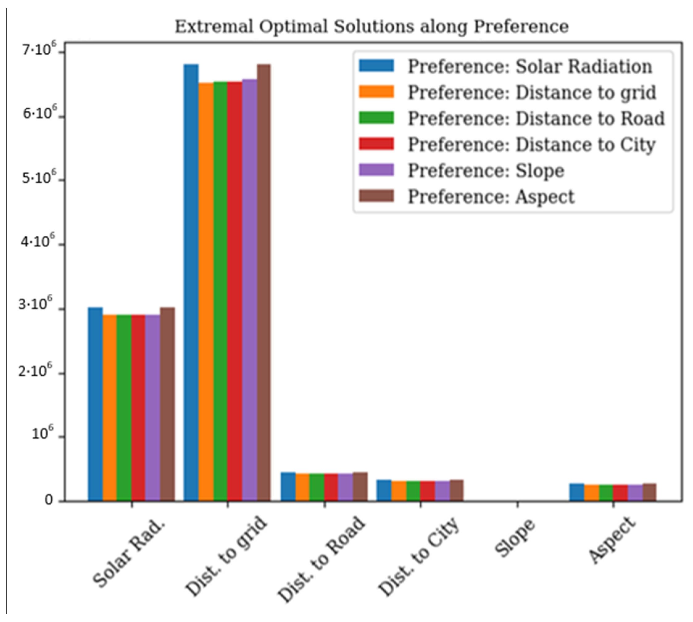
Figure 7, illustrates the comparison of the extremal optimal solutions according to preferences. As the figure shows, the variability along with preferences of the solutions is minimal for four objective functions: total distance to grid, total distance to road, total distance to city, and total slope. The preference of total solar irradiation and total aspect have a competitive behavior in all components of objective functions.
The bar plot contrasts various solutions selected based on the prioritization of objective functions. It is evident that among the diverse optimal solutions, there is minimal variability in the value of each objective. Additionally, it is worth noting that an optimal solution, aligned with the preference of the objective function, yields a total solar radiation of approximately 3000 MWh. Furthermore, the total slope objective consistently exhibits the lowest value among solutions chosen based on objective function preference.

4.3. Optimal Solution Maps

Optimal solution maps typically refer to visual representations or graphical depictions that illustrate the optimal solutions to a given problem across different conditions or parameters. These maps can be generated in various fields, such as optimization, decision-making, or engineering. For example, in optimization problems, an optimal solution map could display how the optimal solution changes as input parameters vary. In decision-making, it might represent the best choices under different scenarios. In geographic information systems (GIS), an optimal solution map could show the most efficient locations based on certain criteria.
In the process of producing optimal maps, nearby optimal cell solutions are consolidated to form a unified set of optimal solution cells. Those optimal solution cells that are isolated from others are then removed. Thus, merging the closest solution cells contributes to achieving a coherent visual representation. This practice is particularly beneficial in data visualization or geographical mapping scenarios, where merging cells simplifies intricate structures and enhances information conveyance to stakeholders. Importantly, merging optimal solution cells can enhance result accuracy [38]. This is because individual solutions may be proximate or overlapping, and merging ensures a comprehensive consideration of all pertinent information, resulting in more precise outcomes.
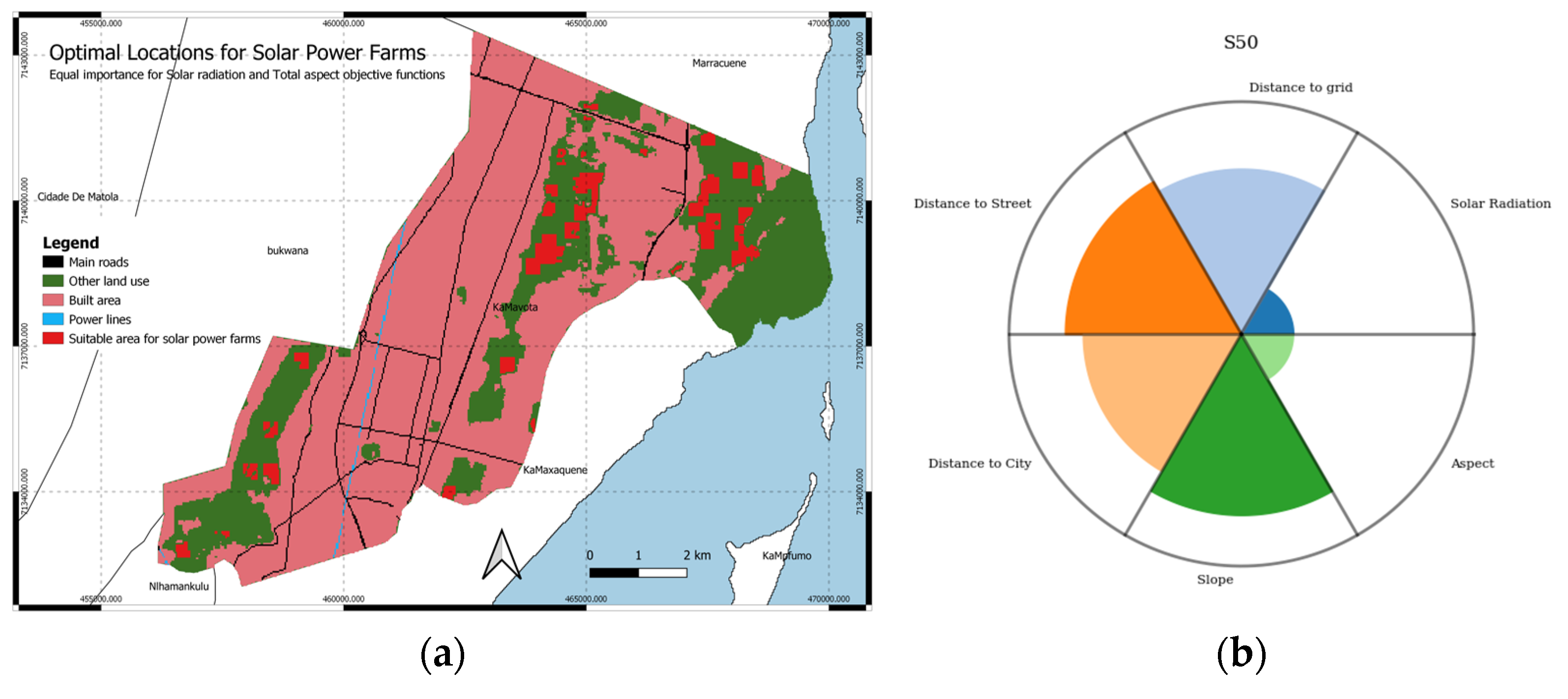
Optimal solution maps depict the ideal locations for establishing solar farms. These maps are generated based on solutions identified on the Pareto front. Decision-makers can select solutions according to their preferences for specific objective functions. It is important to emphasize that all presented solutions are Pareto-optimal, and trade-offs exist among them. Here, we illustrate two decision-making scenarios as examples, reflecting possible preferences of decision-makers. In one scenario, the sixth objective function (maximum aspect) is prioritized (Figure 8), while in another scenario, equal weight is given to all objective functions (Figure 9).

5. Discussion

This section discusses performance metrics of the algorithm for the problem in hand. The running performance metrics are key indicators that help algorithms gauge their progress, identify areas for improvement, and track their overall fitness levels. Effective performance tracking involves setting specific, measurable, achievable, relevant, and time-bound goals, regularly monitoring progress, and adjusting training plans as needed.

5.1. Running Performance Metrics

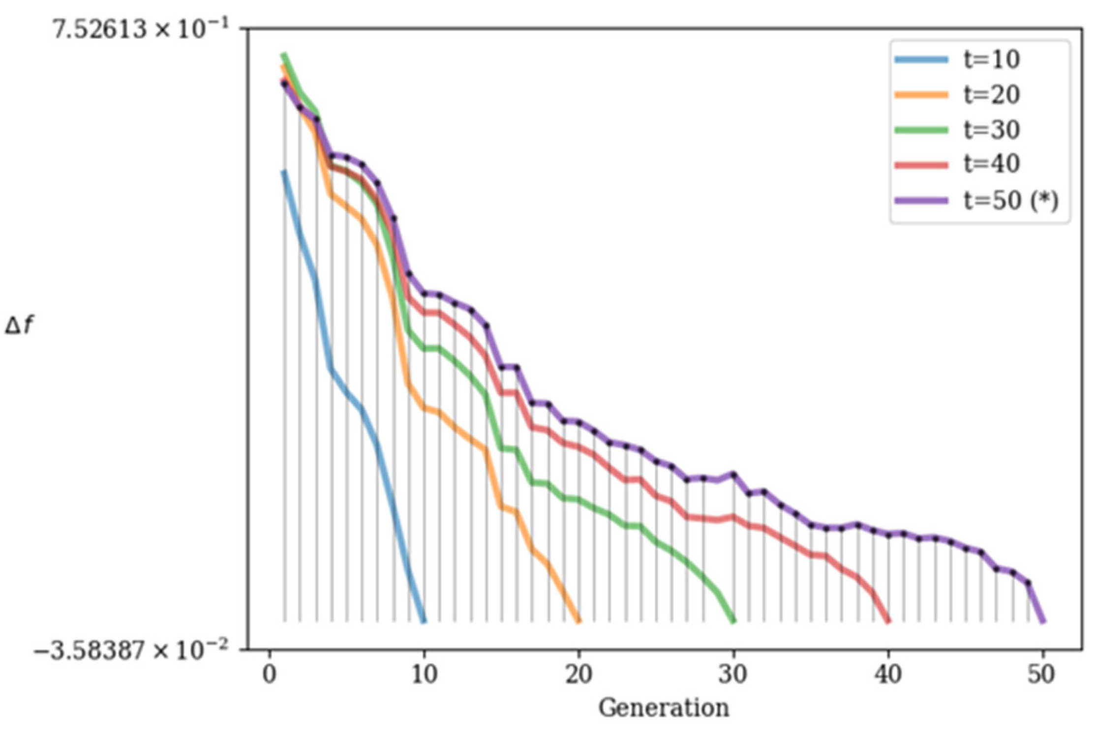
The running performance metric [39] is a measurement and indicator used to assess various aspects of performance, including speed, endurance, efficiency, and overall fitness. An alternative method for assessing convergence involves monitoring metrics. Convergence is indicated when the change becomes minimal or attains a predefined threshold. A convergence plot provides a visual depiction of the evolution of the objective function or pertinent metrics throughout iterations. This graphical representation facilitates the recognition of trends and convergence patterns. The running metric Δf demonstrates the fluctuation in the objective space between consecutive generations and leverages the algorithm’s survival to highlight improvements.
The running metric analysis reveals that the performance of the algorithm improved significantly in the first 10 generations (considering t = 10), as shown in Figure 10. From the tenth to the twentieth generation (regarding t = 20), the algorithm showed an improvement in all generations. From the twentieth to the thirtieth generations (considering t = 30), the algorithm presented an improvement from the twenty-fifth to the thirtieth generation. From the thirtieth to the fortieth generation (considering t = 40), the algorithm presented an improvement from the thirty-eighth to the fortieth generation, and to the fiftieth generation, the algorithm showed an improvement from the forty-eighth to the fiftieth generation (regarding t = 50).
The way we look at progress in solving the site selection problems for solar power farms is through the running metric. It compares the front sets in different generations to see how well the algorithm is improving solutions over time. By tracking this metric, we can see how NSGA-II converges toward the best solutions for solar farm sites. As each generation passes, we notice that the running metric steadily decreases, showing us that the algorithm is becoming closer to optimal solutions. This steady decrease tells us that the Pareto front set is stabilizing, confirming that NSGA-II is on track to find high-quality and relevant solutions for solar farm site selection.

5.2. Performance Tracking

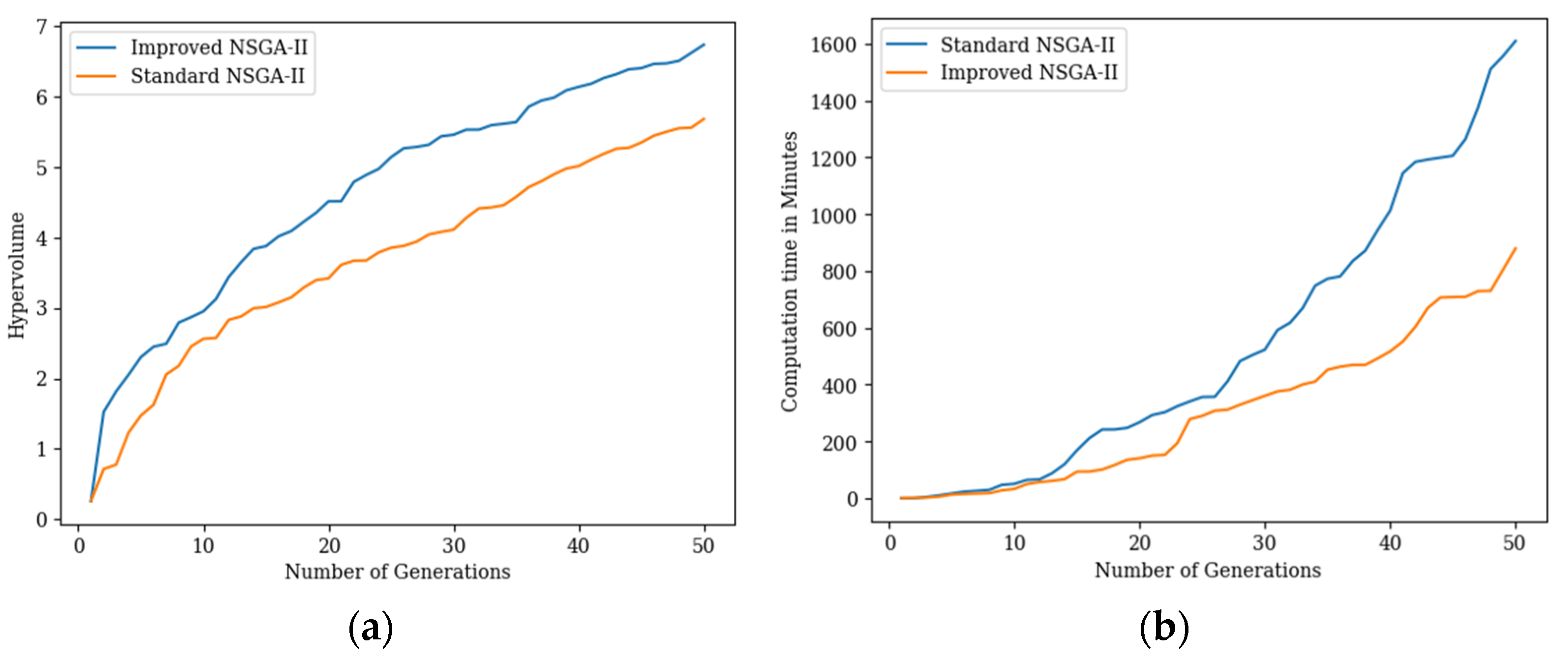
In this section, we compare the quality of the solution and the performance of two algorithms, the standard NSGA-II and the improved NSGA-II in the site selection solar power farm problem (Figure 11). To compare the quality of the solution, we have used the hypervolume indicator which serves as a metric for assessing the solution’s quality by determining the total volume within the objective space that is controlled by the Pareto front solutions [40]. This tool is commonly utilized in evolutionary algorithms to evaluate and compare the effectiveness of diverse algorithms or solutions. The Hypervolume indicator has shown that the quality of the solution of the improved NSGA-II is better than the quality of the solution of the standard NSGA-II. The hypervolume quantifies the volume of the objective space that is dominated by a given set of solutions. Hypervolume is particularly useful when dealing with multiple conflicting objectives, and the goal is to find a set of solutions that represent a trade-off between these objectives.
As shown in Figure 11a, the improved NSGA-II is effective in terms of Pareto front quality (the blue graph is above the orange one) for our optimization problem. However, as illustrated in Figure 11b, the computational time increases along with the number of generations. The improved NSGA-II has a better performance than the standard NSGA-II.

6. Conclusions

The generation of clean energy plays a crucial role in fostering technological progress and ensuring sustainability. Solar energy, categorized among renewable sources, is considered environmentally friendly due to its abundant, continuous, and renewable nature. The site selection for solar power farms is a crucial and strategic decision that significantly influences the performance, efficiency, and overall success of the solar energy project. It is a key step in the planning and development of a successful and sustainable solar power farm.
In this study, we developed a MOO model for the site selection of solar power farms using an improved NSGA-II algorithm, and applied the model to a district in Maputo, Mozambique. The optimal site maps are produced, based on scenarios where decision-makers can choose the optimal solutions from the trade-off solutions based on their preferences or priorities on the criteria. We also measured the performance of the implemented method. The hypervolume indicator showed that the use of a two-point crossover operator in NSGA-II increases the solution quality at the cost of performance. Therefore, MOO techniques, and more specifically the NSGA-II algorithm used in this study, were indicated to be a proper approach for proposing solutions for the sustainable planning of solar farms, where multiple conflicting criteria with spatial components make the decision-making complex.
The research findings can provide significant support in decision-making toward sustainable energy transition. First, the site selection for solar farms in Mozambique involves a comprehensive and multifaceted decision-making process that balances technical, economic, environmental, and social factors to ensure the successful implementation of solar energy projects. By considering various factors like geography, environment, economics, and society, this research presents a thorough framework that aims to strike a balance among different goals to pinpoint the most appropriate sites for solar farms. The generated optimal locations for solar farms in Maputo, Mozambique, from the MOO model has the potential to significantly improve decision-making processes related to the development of renewable energy structures. This indicates the complicated and multifaceted characteristics of the site selection process for solar farms. Second, the research findings, especially the optimal Pareto front and the optimal solution maps, demonstrate how important it is to balance multiple goals when making policies. As two decision-making scenarios illustrated in Figure 8 and Figure 9, when different weights are designated to the objective functions, the different optimal location maps are generated for the site selection of solar farms. It implies that the various preferences of stakeholders and policy-makers need to be taken into account while implementing the solar farm projects. This research lays a solid foundation for choosing optimal solar farm sites in Mozambique, which is conducted in a comprehensive way to support decision-making and without disrupting ecologically sensitive areas and the negative influences on environment and society.
Moreover, the produced practical solutions also align perfectly with the Sustainable Development Goals (SDGs), not just in Mozambique but potentially everywhere else in the world. On the one hand, the site selection of solar farms in Mozambique plays a pivotal role in achieving the SDGs, particularly those related to affordable and clean energy, climate action, and sustainable cities and communities. By harnessing the country’s abundant solar radiation, Mozambique can significantly increase its renewable energy capacity, reducing reliance on fossil fuels and contributing to SDG 7 (Affordable and Clean Energy) and SDG 13 (Climate Action) by reducing greenhouse gas emissions. On the other hand, the entire site selection process also entails thorough environmental and social impact assessments to avoid adverse effects on ecosystems and local communities, aligning with SDG 15 (Life on Land) and SDG 11 (Sustainable Cities and Communities). Thus, a strategic and well-considered site selection process for solar farms not only boosts renewable energy production but also aligns with multiple SDGs, driving comprehensive sustainable development across the nation.

Author Contributions

T.S. was responsible for conceptualization, methodology, formal analysis, software, investigation writing—original draft preparation, resources, and writing. P.Z. contributed to methodology, data curation, analysis, and writing—review and editing. A.S. contributed to supervision and project administration. P.P. was responsible for supervision, project administration, and writing—review and editing. A.M. was responsible for the idea, writing—review and editing, supervision, and project administration. All authors have read and agreed to the published version of the manuscript.

Funding

This research was funded by the Swedish International Development Agency (SIDA) through the Eduardo Mondlane University of Mozambique—Sweden program, Geographical Information Science (GIS) subprogram 1.3.1 and a grant agreement between Sweden, the Government of Mozambique, and the Eduardo Mondlane University regarding the “Eduardo Mondlane University and Sweden Research Partnership 2017–2022”.

Institutional Review Board Statement

Not applicable.

Informed Consent Statement

Not applicable.

Data Availability Statement

The road network and power lines are available at https://download.geofabrik.de/africa/mozambique.html created from OpenStreetMap accessed on 12 December 2023. The Digital Elevation Model (DEM) was downloaded from https://www.eoportal.org/satellite-missions/alos-3#prism-2-panchromatic-remote-sensing-instrument-for-stereo-mapping-2 (accessed on 3 January 2024).

Conflicts of Interest

The authors declare no conflicts of interest.

References

  1. Owusu, P.A.; Asumadu-Sarkodie, S. A review of renewable energy sources, sustainability issues and climate change mitigation. Cogent Eng. 2016, 3, 1167990. [Google Scholar] [CrossRef]
  2. Olabi, A.G.; Abdelkareem, M.A. Renewable energy and climate change. Renew. Sustain. Energy Rev. 2022, 158, 112111. [Google Scholar] [CrossRef]
  3. Ellabban, O.; Abu-Rub, H.; Blaabjerg, F. Renewable energy resources: Current status, future prospects and their enabling technology. Renew. Sustain. Energy Rev. 2014, 39, 748–764. [Google Scholar] [CrossRef]
  4. Islam, M.T.; Huda, N.; Abdullah, A.B.; Saidur, R. A comprehensive review of state-of-the-art concentrating solar power (CSP) technologies: Current status and research trends. Renew. Sustain. Energy Rev. 2018, 91, 987–1018. [Google Scholar] [CrossRef]
  5. Cristóvão, L.; Chichango, F.; Massinga, P., Jr.; Macanguisse, J. The Potential of Renewable Energy in Mozambique: An Overview. J. Energy Technol. Policy 2021, 11. [Google Scholar] [CrossRef]
  6. Hankins, M. A Renewable Energy Plan for Mozambique; Justica Ambiental: Maputo, Mozambique, 2009. [Google Scholar]
  7. Wasinee, W. The Potential of Biomass Fuel and Land Suitability for Biomass Power Plant based on GIS Spatial Analysis in the Nakhon Ratchasima Province, Thailand. Chem. Eng. Trans. 2020, 78, 325–330. [Google Scholar] [CrossRef]
  8. Xu, Y.; Li, Y.; Zheng, L.; Cui, L.; Li, S.; Li, W.; Cai, Y. Site selection of wind farms using GIS and multi-criteria decision making method in Wafangdian, China. Energy 2020, 207, 118222. [Google Scholar] [CrossRef]
  9. Aldrin Wiguna, K.; Sarno, R.; Ariyani, N.F. Optimization Solar Farm site selection using Multi-Criteria Decision Making Fuzzy AHP and PROMETHEE: Case study in Bali. In Proceedings of the 2016 International Conference on Information & Communication Technology and Systems (ICTS), Surabaya, Indonesia, 12 October 2016; IEEE: New York, NY, USA, 2016; pp. 237–243. [Google Scholar]
  10. Noorollahi, Y.; Ghenaatpisheh Senani, A.; Fadaei, A.; Simaee, M.; Moltames, R. A framework for GIS-based site selection and technical potential evaluation of PV solar farm using Fuzzy-Boolean logic and AHP multi-criteria decision-making approach. Renew. Energy 2022, 186, 89–104. [Google Scholar] [CrossRef]
  11. Barros, E.G.D.; Van Aken, B.B.; Burgers, A.R.; Slooff-Hoek, L.H.; Fonseca, R.M. Multi-Objective optimization of solar park design under climatic uncertainty. Sol. Energy 2022, 231, 958–969. [Google Scholar] [CrossRef]
  12. Breen, M.; Upton, J.; Murphy, M.D. Photovoltaic systems on dairy farms: Financial and renewable multi-objective optimization (FARMOO) analysis. Appl. Energy 2020, 278, 115534. [Google Scholar] [CrossRef]
  13. Sengupra, R.N.; Gupta, A.; Dutta, J. Decision Sciences. Theory and Practice; Taylor & Francus Group: Boca Raton, FL, USA, 2017. [Google Scholar]
  14. Sicuaio, T.; Zhao, P.; Pilesjo, P.; Shindyapin, A.; Mansourian, A. Sustainable and Resilient Land Use Planning: A Multi-Objective Optimization Approach. ISPRS Int. J. Geo-Inf. 2024, 13, 99. [Google Scholar] [CrossRef]
  15. Giagkiozis, I.; Fleming, P.J. Methods for multi-objective optimization: An analysis. Inf. Sci. 2015, 293, 338–350. [Google Scholar] [CrossRef]
  16. Klamroth, K.; Lacour, R.; Vanderpooten, D. On the representation of the search region in multi-objective optimization. Eur. J. Oper. Res. 2015, 245, 767–778. [Google Scholar] [CrossRef]
  17. Yousefi, H.; Hafeznia, H.; Yousefi-Sahzabi, A. Spatial Site Selection for Solar Power Plants Using a GIS-Based Boolean-Fuzzy Logic Model: A Case Study of Markazi Province, Iran. Energies 2018, 11, 1648. [Google Scholar] [CrossRef]
  18. Uyan, M. GIS-based solar farms site selection using analytic hierarchy process (AHP) in Karapinar region, Konya/Turkey. Renew. Sustain. Energy Rev. 2013, 28, 11–17. [Google Scholar] [CrossRef]
  19. Chiarani, E.; Antunes, A.F.B.; Drago, D.; Oening, A.P.; Paschoalotto, L.A.C. Optimal Site Selection Using Geographical Information System (GIS) Based Multi-criteria Decision Analysis (MCDA): A Case Study To Concentrated Solar Power Plants (CSP) In Brazil. Anu. Inst. Geociênc. 2023, 46, 48188. [Google Scholar] [CrossRef]
  20. Colak, H.E.; Memisoglu, T.; Gercek, Y. Optimal site selection for solar photovoltaic (PV) power plants using GIS and AHP: A case study of Malatya Province, Turkey. Renew. Energy 2020, 149, 565–576. [Google Scholar] [CrossRef]
  21. Uyan, M. Optimal site selection for solar power plants using multi-criteria evaluation: A case study from the Ayranci region in Karaman, Turkey. Clean Technol. Environ. Policy 2017, 19, 2231–2244. [Google Scholar] [CrossRef]
  22. Kazemi, R.; Moeini-Aghtaie, M.; Omidvar, H.; Sharifi, A.; Javadian, M. Multi-objective optimization for solar farm site selection considering environmental, social, and economic aspects. J. Clean. Prod. 2020, 243. [Google Scholar] [CrossRef]
  23. Blanc, P.; Espinar, B.; Geuder, N.; Gueymard, C.; Meyer, R.; Pitz-Paal, R.; Reinhardt, B.; Renné, D.; Sengupta, M.; Wald, L.; et al. Direct normal irradiance related definitions and applications: The circumsolar issue. Sol. Energy 2014, 110, 561–577. [Google Scholar] [CrossRef]
  24. Karra, K.; Kontgis, C.; Statman-Weil, Z.; Mazzariello, J.C.; Mathis, M.; Brumby, S.P. Global land use/land cover with Sentinel 2 and deep learning. In Proceedings of the 2021 IEEE International Geoscience and Remote Sensing Symposium IGARSS, Brussels, Belgium, 11–16 July 2021; IEEE: New York, NY, USA, 2021; pp. 4704–4707. [Google Scholar]
  25. OpenStreetMap Contributors Planet Dump. 2023. Available online: https://planet.osm.org (accessed on 12 December 2023).
  26. Torres-Sibille, A.D.C.; Cloquell-Ballester, V.-A.; Cloquell-Ballester, V.-A.; Artacho Ramírez, M.Á. Aesthetic impact assessment of solar power plants: An objective and a subjective approach. Renew. Sustain. Energy Rev. 2009, 13, 986–999. [Google Scholar] [CrossRef]
  27. Zhou, Q.; Liu, X. Analysis of errors of derived slope and aspect related to DEM data properties. Comput. Geosci. 2004, 30, 369–378. [Google Scholar] [CrossRef]
  28. Hillier, F.S.; Frederick, S. Hillier. 2021. Available online: https://doi.org/10.1287/0da64ca6-e17a-473d-b876-2df3a5ce2760 (accessed on 12 June 2023).
  29. Roque, P.M.J.; Chowdhury, S.P.D.; Huan, Z. Improvement of Stand-Alone Solar PV Systems in the Maputo Region by Adapting Necessary Parameters. Energies 2021, 14, 4357. [Google Scholar] [CrossRef]
  30. Tafula, J.E.; Justo, C.D.; Moura, P.; Mendes, J.; Soares, A. Multicriteria Decision-Making Approach for Optimum Site Selection for Off-Grid Solar Photovoltaic Microgrids in Mozambique. Energies 2023, 16, 2894. [Google Scholar] [CrossRef]
  31. Blank, J.; Deb, K. Pymoo: Multi-Objective Optimization in Python. IEEE Access 2020, 8, 89497–89509. [Google Scholar] [CrossRef]
  32. Izzo, D. Pygmo and Pykep: Open Source Tools for Massively Parallel Optimization in Astrodynamics (The Case of Interplanetary Trajectory Optimization). In Proceedings of the International Conference on Astrodynamics Tools and Techniques—ICATT 2012, Noordwijk, The Netherlands, 29 May–1 June 2012. [Google Scholar]
  33. Tettelaar, K. Towards Multi-objective Bayesian Global Optimization for Space Missions. Bachelor’s Thesis, Leiden University, Leiden, The Netherlands, August 2020. [Google Scholar]
  34. Censor, Y. Pareto optimality in multiobjective problems. Appl. Math. Optim. 1977, 4, 41–59. [Google Scholar] [CrossRef]
  35. Stiglitz, J.E. Pareto Optimality and Competition. J. Finance 1981, 36, 235–251. [Google Scholar] [CrossRef]
  36. Tan, Y.S.; Fraser, N.M. The modified star graph and the petal diagram: Two new visual aids for discrete alternative multicriteria decision making. J. Multi-Criteria Decis. Anal. 1998, 7, 20–33. [Google Scholar] [CrossRef]
  37. Bravi, A.; Longtin, A.; Seely, A.J. Review and classification of variability analysis techniques with clinical applications. Biomed. Eng. OnLine 2011, 10, 90. [Google Scholar] [CrossRef]
  38. Laumanns, M.; Thiele, L.; Deb, K.; Zitzler, E. Combining Convergence and Diversity in Evolutionary Multiobjective Optimization. Evol. Comput. 2002, 10, 263–282. [Google Scholar] [CrossRef]
  39. Blank, J.; Deb, K. A Running Performance Metric and Termination Criterion for Evaluating Evolutionary Multi- and Many-objective Optimization Algorithms. In Proceedings of the 2020 IEEE Congress on Evolutionary Computation (CEC), Glasgow, UK, 19–24 July 2020; IEEE: New Yor, NY, USA, 2020; pp. 1–8. [Google Scholar]
  40. Zitzler, E.; Brockhoff, D.; Thiele, L. The Hypervolume Indicator Revisited: On the Design of Pareto-compliant Indicators via Weighted Integration. In Evolutionary Multi-Criterion Optimization; Lecture Notes in Computer Science; Obayashi, S., Deb, K., Poloni, C., Hiroyasu, T., Murata, T., Eds.; Springer: Berlin/Heidelberg, Germany, 2007; Volume 4403, pp. 862–876. ISBN 978-3-540-70927-5. [Google Scholar]
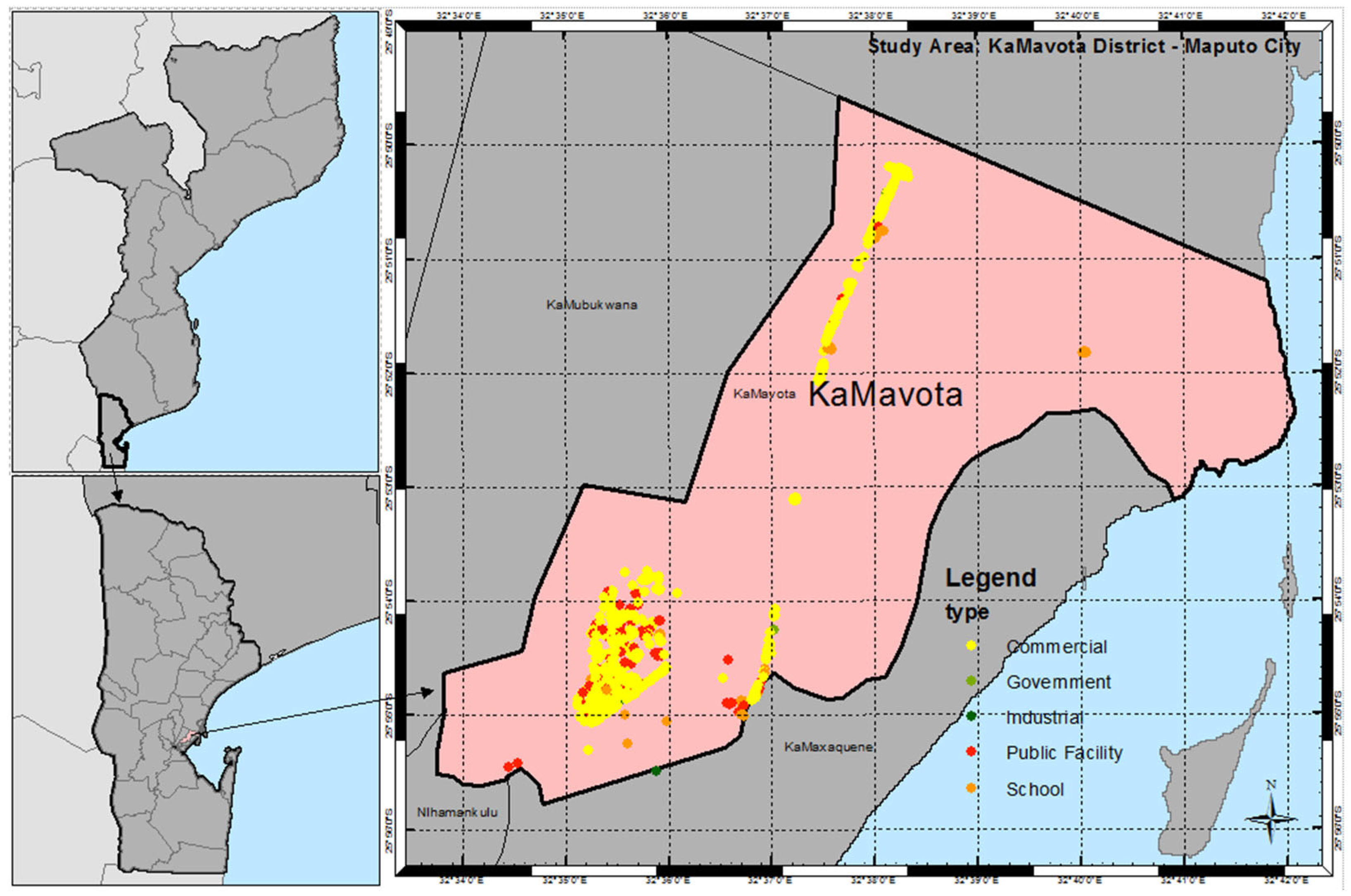
Figure 1. Study area. Area equal 63.32 Km2. (Source: Map made in QGIS 3.12).
Sustainability 16 07333 g001
Figure 2. Data source and factor maps: (a) direct solar irradiation, (b) digital elevation model, (c) slope, (d) aspect, (e) land cover, (f) main road network, and (g) power lines. (Source: Maps made in QGIS 3.12).
Sustainability 16 07333 g002aSustainability 16 07333 g002b
Figure 3. Flow diagram for the methodology. (Source: Figure made in Visio 2016).
Sustainability 16 07333 g003
Figure 4. NSGA II procedure. (Source: Figure made in Visio 2016).
Sustainability 16 07333 g004
Figure 5. Optimal Pareto front set: f1—total solar radiation (in kWh), f2—Total distance to grid (in meters), f3—total distance to road network (in meters), f4—total distance to urban areas (in meters), f5—total slope (in degrees), and f6—total aspect (in degrees). (Source: Figure made in Python 3.9.18).
Sustainability 16 07333 g005
Figure 6. Variability analysis of the Pareto front set. Solar radiation (in kilowatt-hour, kWh), distance to grid (in meters), distance to road (in meters), distance to city (in meters), slope and aspect (in degrees). (Source: Figure made in Python 3.9.18).
Sustainability 16 07333 g006
Figure 7. Comparison of the extremal solutions. Solar radiation (in kilowatt-hour, kWh), distance to grid (in meters), distance to road (in meters), distance to city (in meters), slope and aspect (in degrees). (Source: Figure made in Python 3.9.18).
Sustainability 16 07333 g007
Figure 8. Optimum sites for solar farms, by prioritizing the sixth objective function, on the final Pareto front. (a) Optimal location for solar power farms in red color. (b) Solution corresponding to the optimal map. (Source: Maps made in QGIS 3.12, and figures made in Python 3.9.18).
Sustainability 16 07333 g008
Figure 9. Optimum sites for solar farms, by considering equal weight for all objective functions, on the final Pareto front. (a) Optimal location for solar power farms in red color. (b) Solution corresponding to the optimal map. (Source: Maps made in QGIS 3.12, and figures made in Python 3.9.18).
Sustainability 16 07333 g009
Figure 10. Running metric demonstrates the convergence of the algorithm along with the generation growth. (Source: Figure made in Python 3.9.18). The (*) means the best value achieved.
Sustainability 16 07333 g010
Figure 11. Performance comparison of NSGA-II under one-point and two-point crossover utilization, based on (a) hypervolume analysis and (b) computational time analysis. (Source: Figures made in Python 3.9.18).
Sustainability 16 07333 g011
Disclaimer/Publisher’s Note: The statements, opinions and data contained in all publications are solely those of the individual author(s) and contributor(s) and not of MDPI and/or the editor(s). MDPI and/or the editor(s) disclaim responsibility for any injury to people or property resulting from any ideas, methods, instructions or products referred to in the content.