Article

Analysis of Hydrological Changes in the Fuhe River Basin in the Context of Climate Change

1
School of Soil and Water Conservation, Beijing Forestry University, Beijing 100083, China
2
Technical Centre for Soil, Agriculture and Rural Ecology and Environment, Ministry of Ecology and Environment, Beijing 100012, China
3
Bayannur Municipal Cultivated Land Quality Monitoring and Protection Center, Bayannur 015000, Inner Mongolia, China
4
Institute of Resources and Environment, Beijing Academy of Science and Technology, Beijing 100095, China
5
China Association of Agricultural Science Societies, Beijing 100125, China
*
Authors to whom correspondence should be addressed.
Sustainability 2024, 16(17), 7418; https://doi.org/10.3390/su16177418
Submission received: 12 July 2024 / Revised: 16 August 2024 / Accepted: 16 August 2024 / Published: 28 August 2024

Abstract

:
Against the backdrop of global warming, assessing the effects of climate change on hydrological processes is crucial for local water resource management. Variations in temperature, precipitation, and runoff at four different timescales in the Fuhe River Basin were evaluated based on observational data collected from 1960 to 2020 using the Mann–Kendall test. The findings indicated significant increases in average temperatures for the annual, flood season, and non-flood season periods, rising by 0.0197, 0.0145, and 0.0278 °C every annum, respectively (p < 0.01). Precipitation exhibited non-significant upward trends at all timescales (p > 0.1). The trend in flood season runoff was also non-significantly upward, whereas annual runoff and non-flood season runoff displayed non-significant downward trends (p > 0.1). Flood season temperature decreased with increasing altitude, exhibiting a significant Pearson correlation coefficient of −0.744 at the 0.01 level. Conversely, annual, flood, and non-flood season precipitation significantly increased with increasing altitude, with Pearson correlation coefficients of 0.678 at the 0.01 level, 0.695 at the 0.01 level, and 0.558 at the 0.05 significance level, respectively. Precipitation and runoff exhibited similar trends throughout the year, increasing initially and then decreasing over time, reaching maximum values in June. Climate change is likely responsible for the hydrological alterations in the study basin. The findings of the study could provide references for water resource management decisions in the Fuhe River Basin.

1. Introduction

Climate change is recognized as one of the most critical environmental issues globally, exerting significant influences on regional water circulation [1,2]. Variations in temperature and rainfall are two key aspects of climate change, directly affecting hydrology and hydrological processes [3]. Over the past half-century, global surface temperature has risen more quickly than in any other fifty-year span over the last two millennia, with a substantial increase of 1.1 °C observed from 2011 to 2020 compared to the period from 1850 to 1900 [4]. As temperatures continue to rise, evaporation increases gradually, leading to a decrease in river discharge [5]. Moreover, combined changes in temperature and precipitation can lead to great disasters on seas, rivers, and their wetland ecosystems by impacting sea levels and river discharge [6]. These changes have significant implications for the global water cycle, resulting in extreme hydrological events and reconfiguring water resources globally such as floods and droughts, which, to a certain extent, affect regional water security and sustainable development [7,8,9,10].
Although climate change occurs globally, its effects vary regionally [11]. Various aspects of the water balance in the Mediterranean Basin have been influenced by rising temperatures and decreasing precipitation, resulting in severe water shortages in multiple areas of the region [12]. However, significantly different trends in precipitation were observed as temperatures increased from 1979 to 2019 in different regions of the Yarlung Tsangpo River, with more pronounced effects of climate change during rainy season than that of snowmelt season [1]. Given that long-term temperature and precipitation variables can represent regional climate change [13], it is essential to understand the influences of climatic variation on hydrology and hydrological processes by investigating the evolving characteristics of temperature and precipitation across various regions. This understanding can further provide vital references for the sustainable allocation of water resources.
Poyang Lake, Asia’s biggest wintering migratory bird habitat and the biggest freshwater lake in China, is undergoing significant changes [14]. The climate change and hydrological response of Poyang Lake have been extensively studied [15,16,17]. However, most of the previous studies have concentrated on the changes in annual runoff in the whole basin, with few analyzing the long-term meteorological factors and runoff changes in its sub-basins. Additionally, limited studies have been conducted on the seasonal variations of runoff in sub-basins.
The Fuhe River Basin is the second-biggest tributary of the Poyang Lake Basin. It has abundant water resources, great annual variation in runoff and a significant amount of extreme hydrological events [18,19]. This basin has a substantial influence on the hydrological processes of the Poyang Lake watershed. More surface water runoff is generated during flood season and flows into Poyang Lake, whereas less runoff occurs during non-flood season [20]. Recognizing trends in hydrological time series is essential for regional water resource management and water safety. Therefore, based on observational data collected from meteorological as well as hydrological stations in the Fuhe River Basin, this paper quantitatively analyzes the changing trends in meteorological factors and hydrological changes across four different timescales of annual, monthly, flood, and non-flood season. By combining spatial data analysis with long-term time series and considering land use types and actual management requirements, this study aims to provide scientific support for managing regional water resources, water environment quality improvement, agricultural non-point source pollution prevention and control, as well as flood prevention and disaster reduction.

2. Materials and Methods
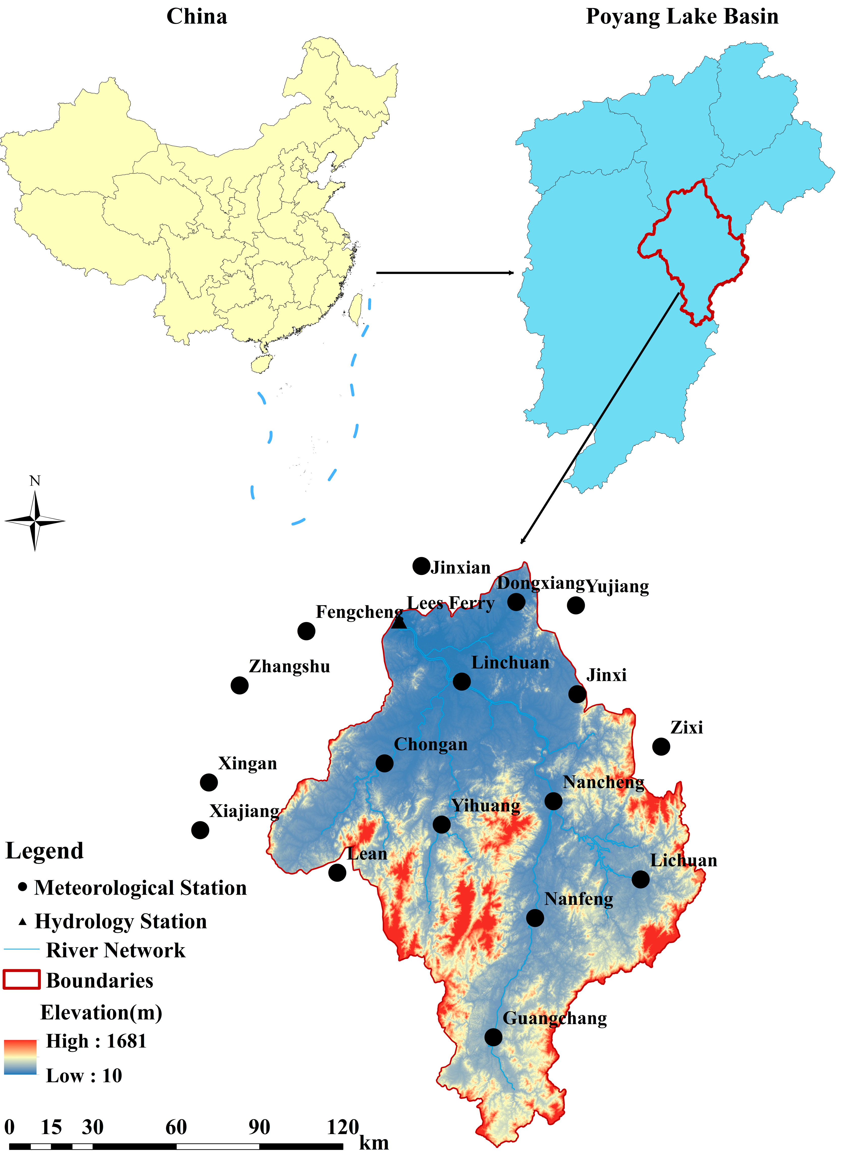
2.1. Study Area

The research was performed in the Fuhe River Basin, which is located within the Yangtze River Basin. Located in the eastern region of Jiangxi Province, China (Figure 1), the study area has a total drainage area of 15,811 km2 above the Lijiadu hydrologic station [18]. The average annual rainfall is roughly 1680 mm [19], but the distribution of rainfall is uneven throughout the year. The main period of precipitation occurs during the flood season, which spans from May to October. The Fuhe River Basin is bordered by mountains to the east, south, and west sides, with an opening to the north-facing Poyang Lake. The terrain slopes from high elevations in the south to lower elevations in the north, gradually sloping towards the Poyang Lake plain area. The average elevation is 219.11 m. The river’s extreme flow varies greatly, exhibiting characteristics of a plain river [18].

2.2. Data Collection and Processing

The data of this research were collected from sixteen meteorological stations (Table 1) and one hydrographic station in the study area. Nine of these meteorological stations are situated in the Fuhe River Basin, and the other seven stations are located near the study region. The selection of these monitoring stations facilitated the interpolation calculation of meteorological data. Daily meteorological precipitation and temperature data from 1960 to 2020 were sourced from the National Climatic Center (NCC) of the China Meteorological Administration (CMA). Rainfall observations start at 20:00 (Beijing time) on the previous day and end at 20:00 on the observation day. The average daily temperature is calculated by averaging four measurements taken at 02:00, 08:00, 14:00, and 20:00. Monthly discharge data from the Lijiadu Hydrological Station (116.16° E, 28.22° N) at the basin exit section were sourced from the Jiangxi Provincial Hydrology Bureau, covering the period from 1980 to 2018. All daily hydro-meteorological parameters were adjusted to monthly and annual variables prior to further analysis. Elevation data were sourced from the Resource and Environmental Science and Data Center (http://www.resdc.cn, accessed on 5 March 2021). The data selected for this study were determined based on availability and record integrity. The spatial distribution of the 16 stations is presented in Figure 1.

2.3. Methodology

2.3.1. Mann–Kendall (MK) Trend Test

The current commonly used trend test methods mainly include parametric and non-parametric tests. In this research, the MK trend test method put forward by Mann and Kendall [21] was adopted to investigate shifts in the hydrological patterns of the Fuhe River Basin over the past 60 years. As a non-parametric time-series trend test method, the MK test is endorsed by the World Meteorological Organization (WMO). Its main advantage is that it can be applied to data series without assuming a specific distribution, including those that are non-normally distributed [3]. The MK test analyzes the relative order of magnitudes rather than the values themselves, and it is not susceptible to interference from outliers, allowing for missing values in a long time series. This aligns well with the characteristics of hydro-meteorological time series, which often exhibit skewness, non-normal distributions, and abnormal maximum or minimum values. Therefore, the MK method is widely used in hydrology and meteorology to analyze time series changes in hydrometeorological factors such as water level, runoff, rainfall, and temperature [13,20].
The fundamental principle of the MK test is as follows:
For a time series x i (where i ranges from 1 to n) with n sample sizes) with n sample sizes, the statistic S is defined as
S = i = 1 n 1 j = i + 1 n s g n ( x j x i )
where the x j and x i represent the corresponding year data values of the time series, n denotes the total length of the data set, and s g n ( x j x i ) is a symbolic function. When x j > x i , s g n = 1 ; when x j = x i , s g n = 0 ; when x j < x i , s g n = 1 .
When n ≥ 8, S follows an approximate normal distribution, with the following mean and variance:
E S = 0
V S = n ( n 1 ) ( 2 n + 5 ) / 18 .
The Z-value of the standardized test statistic is determined by
Z = S 1 V ( S )       S > 0 0 S + 1 V ( S )       S = 0 .
If, in a two-sided test at the α significance level |Z| > Z(1−α/2), the null hypothesis is rejected, and it is considered that the significance of sequence x i tends to increase or decrease.
In this paper, the MK trend test was performed on annual as well as decadal hydro-meteorological data. Trend significance statistics were calculated at 0.1, 0.05, and 0.01 confidence intervals. For significance levels of 0.01, 0.05, and 0.1, the |Z| values were 2.58, 1.96, and 1.64, respectively. A detailed description of the MK test is available in previous studies [20,22,23]. Following Yan’s [13] research method, this study also estimated the trend amplitude.

2.3.2. Trend-Free Pre-Whitening (TFPW)

The MK test assumes independence in the sequence, implying that there should be no autocorrelation. Correlation within the sequence can amplify the significance of the trend and yield different results. In reality, hydrological series in many regions exhibit autocorrelation, which may affect the accuracy of the trend test [21,24]. Therefore, the effect of autocorrelation in hydrological data series should be eliminated for the MK test. TFPW was applied in this research to effectively remove the first-order autocorrelation of time series by stripping trend and residual items from the series, thus avoiding its influence on the MK test results. Detailed explanations of the TFPW method and serial correlation analysis are presented in previous studies [13,22].

2.3.3. Other Analysis Methods

The inverse distance weight (IDW) method was employed for the spatial evaluation of meteorological data. ArcGIS 10.7 software was used for the analysis and mapping procedures. Pearson correlation analysis was conducted on the relevant data using SPSS 25.

3. Results and Discussion

Annual, monthly, flood, and non-flood season temperature as well as precipitation data from 1960 to 2020 were analyzed in this paper. Previous studies on Poyang Lake have different definitions of flood and non-flood seasons. Lei et al. [15] divided one year into a flood season (April to September) and a non-flood season (October to March), whereas Ye et al. [20] divided one year into a wet season (April to June), transition period (July to September), and dry season (October to March). In order to better provide advice for managers, a whole year is classified into a flood season (May to October) and a non-flood season (November to April) according to the China Meteorological Administration’s definition of the main flood season of the seven main rivers in China because the Fuhe River is within the Yangtze River Basin.

3.1. Temperature

3.1.1. Annual Variation Characteristics

The time series of observed average temperature throughout the year during the flood season, as well as during the non-flood season from 1960 to 2020, are shown in Figure 2. The average annual temperature from 1960 to 2020 in the Fuhe River was 17.98 °C (Table 2), with an increase of 0.14 °C compared to the period from 1960 to 2009. The increase may be attributed to the rise in emissions of greenhouse gases caused by human activities. It has also been reported that global greenhouse gas emissions kept rising from 2010 to 2019 due to human activities [4]. As indicated by the MK test results, the annual mean temperature increased significantly with a magnitude of 0.0197 °C per year (p < 0.01) from 1960 to 2020, which could have led to a decrease in river area (Table 2). Soomro et al. [25] demonstrated that the increase in the temperature of Poyang Lake from 2003 to 2023 was associated with a decline in lake surface area of 1600 km2.
The average temperature during the flood season was 25.10 °C, which is higher than the 10.77 °C observed during the non-flood season. Both the flood and non-flood seasons exhibited an upward trend in average temperatures, at rates of 0.0145 °C and 0.0278 °C per year (p < 0.01), respectively. There was a greater increase in average temperature during the non-flood season, compared to the flood season, resulting in a narrowing of the temperature range over the year, with annual mean maximum and minimum temperatures of 18.98 °C and 16.91 °C, respectively. This may be due to a higher rate of temperature increase in winter and spring compared to summer and autumn [13], which also corresponds to the conclusions drawn Ye et al. [20] who reported statistically significant increases in temperature (p < 0.01) for spring and winter, whereas the upward trends were not significant for summer and autumn in the Poyang Lake Basin (p > 0.1) during the period from 1960 to 2007. Moreover, the upward monthly temperature trend was more significant during the non-flood season compared to the flood season (Table 3). Particularly from July to September, the temperature showed a non-significant upward trend.

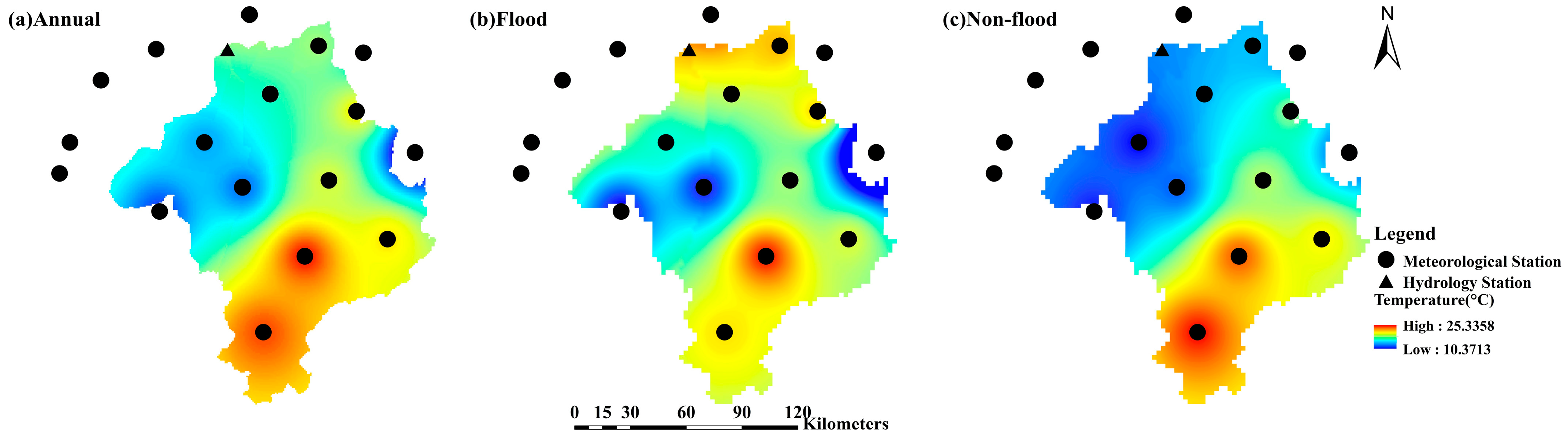
3.1.2. Spatial Variation Characteristics

The spatial pattern of temperature in the Fuhe River Basin is presented in Figure 3. The annual mean temperature gradually decreased from south to north and from the central region towards the east and west, exhibiting a range of 17.51–18.53 °C within the basin. There was minimal variation in temperature among different stations. Notably, there was a dissimilarity in the spatial distribution of temperature between the flood season and the non-flood season conditions. At a significance level of 0.01, a statistically significant inverse relationship was observed between temperature and altitude, with a Pearson’s correlation coefficient value of −0.744. The air temperature was influenced by basin topography, land use patterns, and other factors. The central region of the Fuhe River Basin comprises low mountains, hills, and valley basins. The terrain gradually rises in the south and descends in the north, eventually sloping towards the Poyang Lake plain area [18]. During the flood season, temperatures increased progressively from south to north due to decreasing elevation along the basin’s topography gradient [13].
Figure 4 depicts the spatial variations and trend amplitude of MK test results for mean temperatures of the annual, flood, and non-flood seasons across 16 meteorological stations in the Fuhe River Basin as well as its surrounding area. All stations demonstrated a significant upward trend in both annual and non-flood season mean temperatures at the α = 0.01 level. During the flood season, only the Xiajiang and Congren meteorological stations exhibited a non-significant rising trend. The remaining weather stations demonstrated a significant upward trend, although the significance level varied among stations (Yujiang at α = 0.1, Nanfeng at α = 0.05).
The trend amplitude of average temperature varied slightly among meteorological stations throughout the year, during the flood and the non-flood seasons. The range of annual mean temperature trends was 0.0101 to 0.0298 °C/year. As depicted in Figure 4, the trend amplitude of average temperature usually diminished from west to east. The meteorological stations with the greatest rising trend in average temperature were observed in the western mountains. In other words, the lower the average temperature in the study area, the higher the warming rate. Moreover, the spatial distribution of mean temperature trends during both the flood season and the non-flood season closely resembled that of the annual year. These findings align with Yan et al.’s research conducted in the Miyun Reservoir Basin [13].

3.2. Precipitation

3.2.1. Annual Variation Characteristics

As depicted in Figure 2, the annual average precipitation and flood season precipitation exhibited a consistent pattern of peaks and valleys over 61 years, highlighting the significant impact of flood season precipitation on annual totals. The average annual rainfall in the study area was 1759.45 mm, with the flood season and the non-flood season averages at 997.10 mm and 762.35 mm, respectively. Precipitation averages for the annual period, the flood, and non-flood seasons in the basin displayed a non-significant upward trend, increasing at rates of 3.4485 mm, 2.0603 mm, and 1.7288 mm per year, respectively. This trend aligns not only with historical precipitation data analysis in the region [26] but also with future precipitation predictions [18]. Moreover, the Poyang Lake Basin experienced a continuous increase in total precipitation during the period from 1960 to 2007 [20].
The analysis of monthly precipitation variations revealed a significant increase only in July, at a rate of 1.0794 mm every year at the 0.1 confidence interval, whereas trends in other months were non-significant (Table 3). This could potentially increase the frequency of flooding [20]. April, May, and October showed a non-significant downward trend in precipitation, highlighting variability across different months. June to September displayed an upward trend, indicating intensifying precipitation during the flood season, with implications for increased flood risk, whereas drought may become more prevalent in the dry season [18].

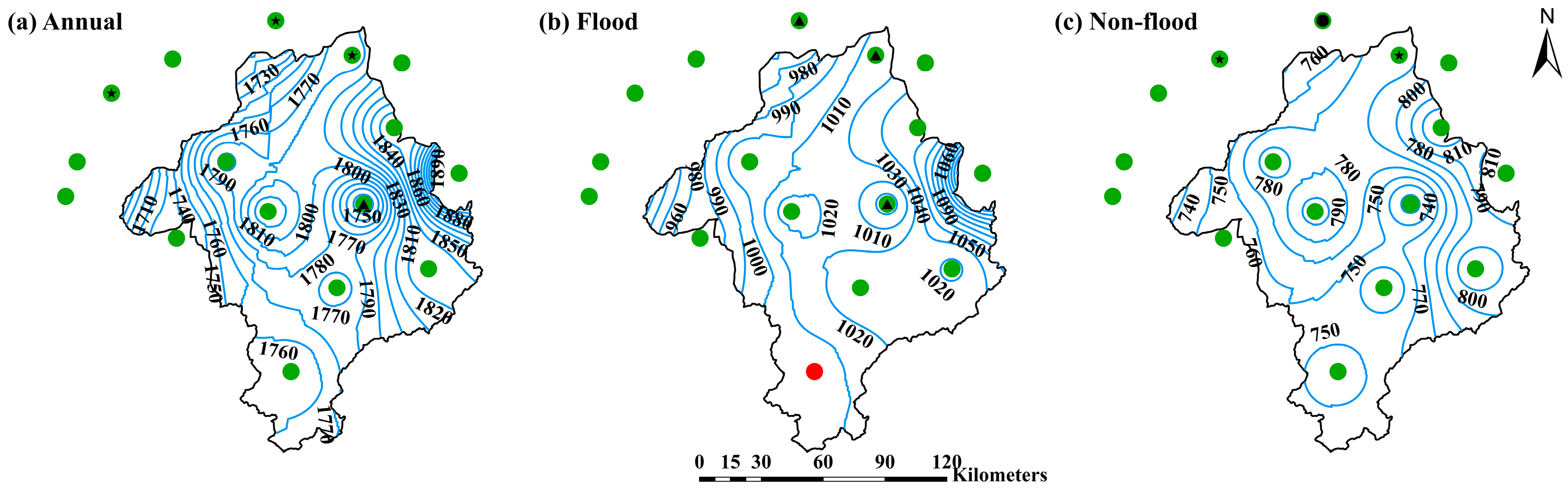
3.2.2. Spatial Variation Characteristics

As illustrated in Figure 5, average annual precipitation decreased gradually from east to west across the basin, ranging between 1672.13 mm and 1944.54 mm. A significant positive correlation was observed between precipitation and altitude, with Pearson correlation coefficients of 0.678 (α = 0.01), 0.695 (α = 0.01), and 0.558 (α = 0.05) for the annual, flood season, and non-flood season precipitation, respectively. The northwestern region, characterized by its lower elevation (Figure 1) and proximity to Poyang Lake, exhibited relatively lower precipitation levels. The spatial distribution patterns of precipitation during the flood and non-flood seasons mirrored those observed annually.
Figure 6 illustrates the spatial distribution trend amplitude of the MK test results for average precipitation in the annual period, the flood, and the non-flood seasons across 16 meteorological stations in the Fuhe River Basin along with its surrounding area. The mean annual precipitation at Zhangshu, Jinxian, and Dongxiang illustrated a significant upward trend at the 0.05 level, with increases of 4.7118, 4.8840, and 5.6957 mm per year, respectively. The average precipitation of the annual period in Nancheng presented a significant upward trend at the 0.1 level, with an annual increase of 4.1484 mm. The rising precipitation trend during the flood season was comparable to that observed throughout the whole year. The precipitation monitored by the Jinxian (α = 0.01), Fengcheng (α = 0.05), Dongxiang (α = 0.05), and Zhangshu (α = 0.1) meteorological stations during the non-flood season revealed a significant increasing trend over 61 years.
The annual mean precipitation trend range of each meteorological station was the largest, ranging from 0.6656 to 5.030 mm per year. However, the increasing trend range of rainfall in the non-flood season was comparatively smaller, varying from 0.3388 to 3.1993 mm per year. As presented in Figure 6, the annual period and the flood season mean precipitation exhibited similar trend amplitudes, generally decreasing from northeast to southwest, which is the opposite of the trend observed for temperature. In conjunction with Figure 6, it can be seen that regions with greater precipitation had a greater rising trend in precipitation.
Many factors affect regional precipitation distribution. For a lake basin, the concentration of land cover and its land use in the lake basin may alter precipitation patterns and lead to flood events [27,28,29]. Additionally, more heavy precipitation and flood events could affect the population, forcing them to move to urban areas [30,31,32]. This would lead to rapid urbanization, which further influences rainfall distribution through changing the properties of the underlying urban surface and local circulations [15]. Moreover, variations in soil moisture and the anthropogenic aerosol accumulations could also affect regional precipitation distribution [13].

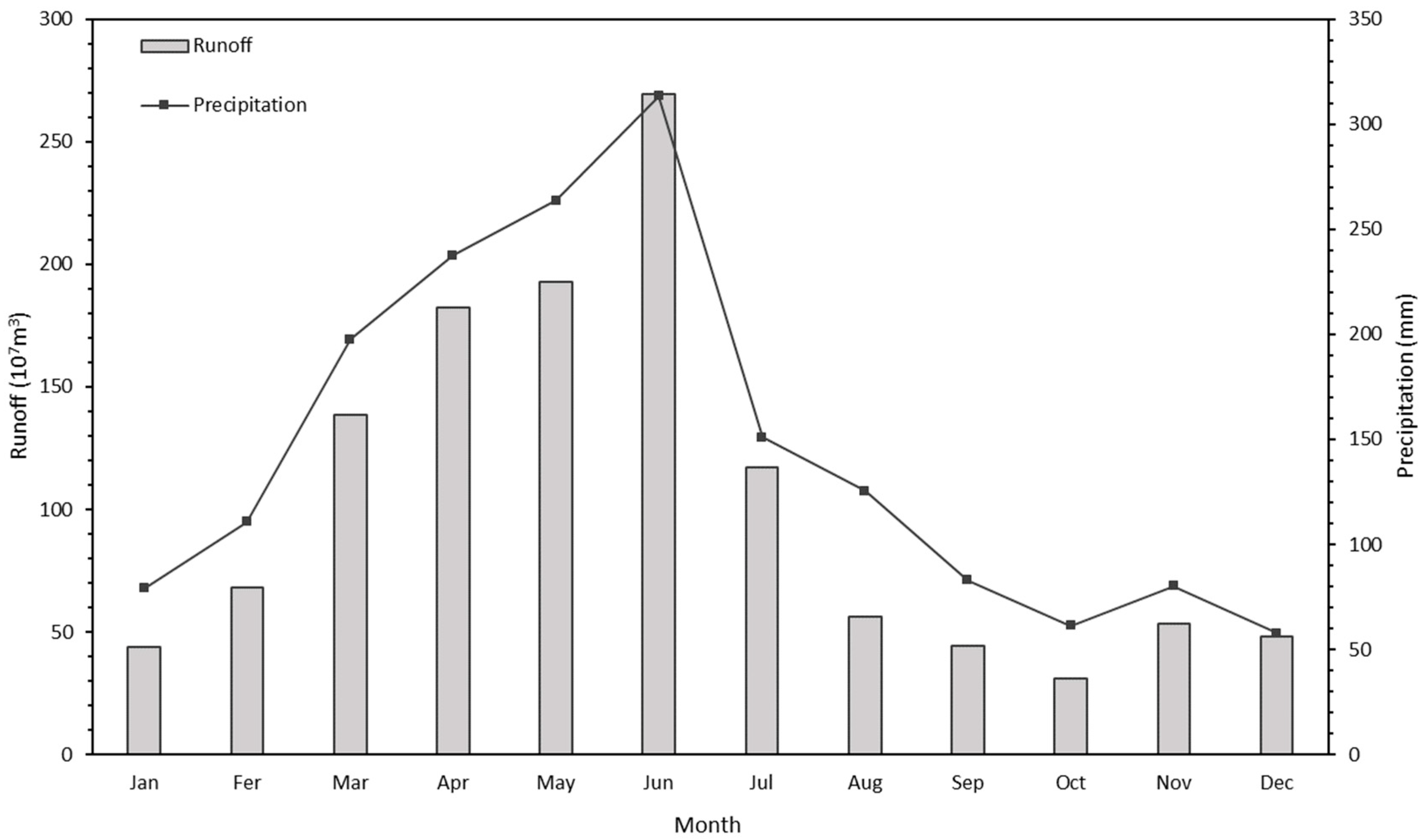
3.3. Hydrological Response Analysis

Figure 2 illustrates the changes in the observed average runoff throughout the year, as well as during the flood and the non-flood seasons, covering the period from 1980 to 2018. The annual minimum, maximum, and average runoff were 470.14 × 10⁷ m3, 2280.12 × 107 m3, and 1245.13 × 107 m3, respectively. The average runoff in the Fuhe River Basin during the flood season was 710.81 × 10⁷ m3, whereas during the non-flood season, it was 534.82 × 10⁷ m3. The flood season runoff constituted approximately 57% of the total annual runoff in the Fuhe River basin, likely due to increased precipitation during the flood season. Previous studies based on precipitation and runoff data in Poyang Lake from 1960 to 2015 demonstrated that the precipitation in flood season and runoff showed a higher correlation, compared with the non-flood season as well as the entire year [15]. In this study, both precipitation and runoff during the flood season exhibited a non-significant upward trend (Table 2).
Over the past 39 years (1980 to 2018), the average annual runoff showed a non-significant decreasing trend, declining at a mean rate of 5.2227 × 10⁷ m3 per year. Regarding runoff, Table 2 indicates contrasting trends for the flood and the non-flood seasons: the former displayed an increasing trend at an average rate of 1.3005 × 10⁷ m3 per year, whereas the latter exhibited a decreasing trend at a magnitude of 3.6587 × 10⁷ m3 per year. This divergence may result from the combined influences of climate change along with human activities [33,34,35]. The increasing trend in precipitation has led to higher runoff during the flood season, and the rising temperatures may have increased evapotranspiration [15,18]. Additionally, human activities have significantly influenced the decrease in runoff in the Fuhe Basin compared to other basins in the Poyang Lake region [14,15,26]. The largest irrigation farmland and systems in Jiangxi Province are situated in the mid-to-lower sections of the Fuhe River, which directly reduces runoff, especially during dry seasons [20].
The mechanisms by which different human activities impact the hydrological processes at a local scale are complex and may accumulate or counteract each other. For example, extensive deforestation and the reduction in water areas before the 1990s significantly increased runoff, whereas widespread afforestation reduced runoff after 2000. Furthermore, water conservancy projects, soil conservation, and urbanization also influence runoff to varying degrees [26,36]. The Hongmen Reservoir on the Fuhe River, with a volume of 5.24 × 10⁸ m3, can alter the spatial distribution of runoff [20]. Therefore, quantitatively differentiating the effects of various human activities along with climate changes on runoff is crucial for water resource management at different spatial scales.
The variations in runoff were strongly related to regional precipitation [7,37,38]. As shown in Figure 7, the monthly distribution pattern of runoff closely mirrored that of rainfall throughout the year, first increasing and then decreasing over time, reaching maximum values in June. Additionally, except for February, March, and September, runoff and precipitation exhibited the same trend during the remaining nine months of the year (Table 3). Similar to Poyang Lake, the runoff from March to June comprised over half of the total annual runoff [20]. Consequently, the downward trend in runoff from March to May significantly impacts the aggregate annual runoff, resulting in a non-significant overall downward trend. Notably, runoff in April exhibited a significant decreasing trend, declining at a rate of −3.4334 × 10⁷ m3 (p < 0.01), whereas changes in other months were not significant. The variations in monthly runoff could intensify the uneven distribution of annual runoff, increasing the difficulty of water resource utilization. As a typical agricultural catchment, the area requires policymakers to be prepared to adjust reservoir management and farmland irrigation strategies in response to changes in runoff.

3.4. Implications for Watershed Management

Understanding the long-term variations in temperature, precipitation, and runoff, along with the influence of meteorological factors on hydrological processes, is essential for formulating and implementing water resource management strategies and non-point source contamination control measures in the Fuhe River Basin. This research utilized the MK trend test to evaluate the temporal and spatial variations of temperature and precipitation over the past 61 years and runoff over the past 39 years. The results indicate an overall increasing trend in both temperature and rainfall, whereas the annual runoff, the flood season runoff, as well as the non-flood season runoff exhibited differing trends. There were also differences in the magnitudes of change, statistical significance, and variations at finer temporal scales among temperature, precipitation, and runoff. This shows that changes in runoff are influenced by various factors beyond climate-related ones, leading to a more complex pattern of transformation rather than a simple linear trend akin to climate change. The spatial distribution of regional precipitation is increasingly imbalanced. Combined with predictions of future hydrological changes in the Fuhe River Basin and the Poyang Lake Basin from previous studies, it may be inferred that the runoff in the basin will increasingly be impacted by climate change [14,15,18]. The synergistic effect of rising temperatures and increasing precipitation, when combined with land use changes, indicates that meteorological factors remain the primary drivers of hydrological changes. This suggests a rising risk of extreme hydrological events. Temporal and spatial changes indicate that the difference between the flood and non-flood season runoff will become more pronounced, leading to more frequent floods and droughts. This poses a threat to local agricultural production and presents challenges for water resource management and regulation.
Non-point source contamination in the Poyang Lake has been a persistent challenge [39], contributing to ongoing concerns about its water quality [40,41,42]. It is vital to minimize non-point source pollutants to ensure the safety of drinking water in Jiangxi Province. As a sub-basin within Poyang Lake, the Fuhe River Basin directly affects the water quality of Poyang Lake. Drought conditions, which primarily affect surface runoff and soil water, significantly influence changes in sediment export, with hydrological drought being a key factor in decreasing nutrient loads [43]. The primary land use type in the Fuhe River Basin is agricultural land, and the local economy is heavily based on agriculture, which may intensify agricultural non-point source pollution. Therefore, local management must strengthen long-term monitoring of the water quantity and quality of the Fuhe River as it enters Poyang Lake, particularly in light of climate change. Moreover, it is critical to increase monitoring frequency during critical periods. The spatial patterns of average annual rainfall, regional land utilization, and farming management practices can help identify the potential nutrient loss areas. This allows for the tracing of non-point source pollution caused by agriculture and the precise location of high fertilizer application areas in crop production as well as major pollution emission areas in the breeding industry. The research findings can guide measures to reduce fertilizer usage, such as adjusting crop structures, integrating water and fertilizer, and other strategies to minimize nutrient loss. To manage livestock and poultry manure, centralized disposal should be implemented to prevent nutrient runoff and maintain water quality.

4. Conclusions

Increased regional climate change has significantly impacted the hydrological processes of the Fuhe River Basin in the context of global warming. This paper identified the spatial and temporal changes in annual, monthly, flood and non-flood season temperature, precipitation, and runoff from 1960 to 2020. The MK test revealed a long-term, significantly upward trend in temperature (p < 0.01) and a non-significant increasing trend in precipitation (p > 0.1). Runoff in the annual and non-flood season decreased non-significantly, whereas runoff in the flood season exhibited a non-significant increasing trend (p > 0.1). Monthly trends in temperature, rainfall, and runoff were more complex. Spatial variations in the trends of average temperature, precipitation, and runoff differed. A significant negative correlation was found between temperature and altitude in the flood season, whereas annual, flood and non-flood season precipitation exhibited the opposite trend (p < 0.01). The magnitude of the average temperature trend typically decreased from west to east. The annual trends in the distribution of runoff and precipitation were similar. Influenced by temperature and precipitation, the spatial and temporal variability of runoff in the Fuhe River Basin gradually increased, greatly increasing the probability of floods and droughts. Therefore, reasonable water resource regulation and management measures should be implemented to promote the safe utilization of water resources.

Author Contributions

Conceptualization, L.M. and J.Y.; methodology, L.M.; software, L.M. and Z.Z.; validation, L.M. and Z.M.; investigation, Z.Z., Z.M. and X.C.; resources, Z.Z. and J.Y.; writing—original draft preparation, L.M. and Z.M.; writing—review and editing, L.M. and J.Y; visualization, L.M., Z.M. and X.Y.; supervision, J.Y. and X.Y.; funding acquisition, X.C. All authors have read and agreed to the published version of the manuscript.

Funding

This research was funded by Protection and Restoration of the Yangtze River, No. 2022-LHYJ-02-0304-05.

Institutional Review Board Statement

Not applicable.

Informed Consent Statement

Not applicable.

Data Availability Statement

The data presented in this study are available on request from the corresponding author.

Conflicts of Interest

The authors declare no conflicts of interest.

References

  1. Wu, Y.Y.; Fang, H.W.; He, G.J.; Huang, L.; Wang, J.Y. Climate-driven changes in hydrological and hydrodynamic responses in the Yarlung Tsangpo River. J. Hydrol. 2021, 598, 126267. [Google Scholar] [CrossRef]
  2. Chang, Y.; Liu, Y.; Liu, L. Contrasting hydrological responses to climate change in two adjacent catchments dominated by karst and nonkarst. J. Hydrol. 2023, 625, 130013. [Google Scholar] [CrossRef]
  3. Wu, Y.Y.; Fang, H.W.; Huang, L.; Ouyang, W. Changing runoff due to temperature and precipitation variations in the dammed Jinsha River. J. Hydrol. 2020, 582, 124500. [Google Scholar] [CrossRef]
  4. IPCC Sections. Climate Change 2023: Synthesis Report. Contribution of Working Groups I, II and III to the Sixth Assessment Report of the Intergovernmental Panel on Climate Change; Core Writing Team, Lee, H., Romero, J., Eds.; IPCC: Geneva, Switzerland, 2023; pp. 35–115. [Google Scholar]
  5. Grafton, R.Q.; Pittock, J.; Davis, R.; Williams, J.; Fu, G.; Warburton, M.; Udall, B.; McKenzie, R.; Yu, X.; Che, N.; et al. Global insights into water resources, climate change and governance. Nat. Clim. Change 2013, 3, 315–321. [Google Scholar] [CrossRef]
  6. Mitsch, W.J.; Hernandez, M.E. Landscape and climate change threats to wetlands of North and Central America. Aquat. Sci. 2013, 75, 133–149. [Google Scholar] [CrossRef]
  7. Mahdaoui, K.; Chafiq, T.; Asmlal, L.; Tahiri, M. Assessing hydrological response to future climate change in the Bouregreg watershed, Morocco. Sci. Afr. 2024, 23, e02046. [Google Scholar] [CrossRef]
  8. Kotz, M.; Levermann, A.; Wenz, L. The effect of rainfall changes on economic production. Nature 2022, 601, 223–227. [Google Scholar] [CrossRef]
  9. Badika, P.; Raghuvanshi, A.S.; Agarwal, A. Climate change impact assessment on the hydrological response of the Tawa basin for sustainable water management. Groundw. Sustain. Dev. 2024, 26, 101249. [Google Scholar] [CrossRef]
  10. Mitiku, A.B.; Meresa, G.A.; Mulu, T.; Woldemichael, A.T. Examining the impacts of climate variabilities and land use change on hydrological responses of Awash River basin, Ethiopia. HydroResearch 2023, 6, 16–28. [Google Scholar] [CrossRef]
  11. Trajkovic, S.; Kolakovic, S. Wind-adjusted Turc equation for estimating reference evapotranspiration at humid European locations. Hydrol. Res. 2009, 40, 45–52. [Google Scholar] [CrossRef]
  12. Noto, L.V.; Cipolla, G.; Francipane, A.; Pumo, D. Climate change in the Mediterranean Basin (Part I): Induced alterations on climate forcings and hydrological processes. Water Resour. Manag. 2023, 37, 2287–2305. [Google Scholar] [CrossRef]
  13. Yan, T.Z.; Bai, Z.Y. Spatial and temporal changes in temperature, precipitation, and streamflow in the Miyun Reservoir Basin of China. Water 2017, 9, 78. [Google Scholar] [CrossRef]
  14. Gong, L.; Zhang, X.; Pan, G.Y.; Zhao, J.Y.; Zhao, Y. Hydrological responses to co-impacts of climate change and land use/cover change based on CMIP6 in the Ganjiang River, Poyang Lake basin. Anthropocene 2023, 41, 100368. [Google Scholar] [CrossRef]
  15. Lei, X.Y.; Gao, L.; Wei, J.H.; Ma, M.M.; Xu, L.G.; Fan, H.X.; Li, X.H.; Gao, J.Y.; Dang, H.F.; Chen, X.W.; et al. Contributions of climate change and human activities to runoff variations in the Poyang Lake Basin of China. Phys. Chem. Earth Parts A/B/C 2021, 123, 103019. [Google Scholar] [CrossRef]
  16. Guo, H.; Hu, Q.; Jiang, T. Annual and seasonal streamflow responses to climate and land-cover changes in the Poyang Lake basin, China. J. Hydrol. 2008, 355, 106–122. [Google Scholar] [CrossRef]
  17. Sun, S.L.; Chen, H.S.; Ju, W.M.; Song, J.; Zhang, H.; Sun, J.; Fang, Y.J. Effects of climate change on annual streamflow using climate elasticity in Poyang Lake Basin, China. Theor. Appl. Climatol. 2013, 112, 169–183. [Google Scholar] [CrossRef]
  18. Ma, H.; Zhong, L.; Fu, Y.F.; Cheng, M.L.; Wang, X.A.; Cheng, M.; Chang, Y.X. A study on hydrological responses of the Fuhe River Basin to combined effects of land use and climate change. J. Hydrol. Reg. Stud. 2023, 48, 101476. [Google Scholar] [CrossRef]
  19. Lu, J.Z.; Liu, Z.X.; Liu, W.Z.; Chen, X.L.; Ling, Z. Assessment of CFSR and CMADS weather data for capturing extreme hydrologic events in the Fuhe River Basin of the Poyang Lake. J. Am. Water Resour. Assoc. 2020, 56, 917–934. [Google Scholar] [CrossRef]
  20. Ye, X.C.; Zhang, Q.; Liu, J.; Li, X.H.; Xu, C.Y. Distinguishing the relative impacts of climate change and human activities on variation of streamflow in the Poyang Lake catchment, China. J. Hydrol. 2013, 494, 83–95. [Google Scholar] [CrossRef]
  21. Burn, D.; Elnur, M. Detection of hydrologic trends and variability. J. Hydrol. 2002, 255, 107–122. [Google Scholar] [CrossRef]
  22. Yue, S.; Pilon, P.; Phinney, B.; Cavadias, G. The influence of autocorrelation on the ability to detect trend in hydrological series. Hydrol. Process. 2002, 16, 1807–1829. [Google Scholar] [CrossRef]
  23. Singh, S.; Singh, S.K.; Kanga, S.; Shrivastava, P.K.; Sajan, B.; Meraj, G.; Kumar, P.; Đurin, B.; Kranjčić, N.; Dogančić, D. Analysis of hydrological changes in the Banas River: Analysing Bisalpur Dam impact and trends of the water scarcity. Results Eng. 2024, 22, 101978. [Google Scholar] [CrossRef]
  24. Zhang, W.; Villarini, G.; Vecchi, G.; Smith, J. Urbanization exacerbated the rainfall and flooding caused by hurricane Harvey in Houston. Nature 2018, 563, 384–388. [Google Scholar] [CrossRef]
  25. Soomro, S.; Boota, M.W.; Zwain, H.M.; Rasta, M.; Hu, C.H.; Liu, C.S.; Li, Y.H.; Li, A.; Chen, J.J.; Zhu, C.Y.; et al. From lake to fisheries: Interactive effect of climate and landuse changes hit on lake fish catch? Environ. Res. 2024, 258, 119397. [Google Scholar] [CrossRef]
  26. Zhang, Q.; Liu, J.Y.; Singh, V.P.; Gu, X.H.; Chen, X.H. Evaluation of impacts of climate change and human activities on streamflow in the Poyang Lake basin, China. Hydrol. Process. 2016, 30, 2562–2576. [Google Scholar] [CrossRef]
  27. Li, X.H.; Zhang, Q.; Xu, C.Y.; Ye, X.C. The changing patterns of floods in Poyang Lake, China: Characteristics and explanations. Nat. Hazard. 2015, 76, 651–666. [Google Scholar] [CrossRef]
  28. Tang, Y.H.; Sun, Y.; Han, Z.Y.; Soomro, S.-E.H.; Wu, Q.; Tan, B.Y.; Hu, C.H. Flood forecasting based on machine learning pattern recognition and dynamic migration of parameters. J. Hydrol. Reg. Stud. 2023, 47, 101406. [Google Scholar] [CrossRef]
  29. Yang, F.; Zhao, C.C.; Wang, J.Y.; Liu, C.S.; Sun, Y.; Soomro, S.-E.H.; Hu, C.H. Grid-quantification study on the effect of rapid urbanization on hydrological processes. Water Supply 2022, 22, 5383–5872. [Google Scholar] [CrossRef]
  30. Soomro, S.-E.-H.; Hu, C.H.; Boota, M.W.; Ahmed, Z.; Liu, C.S.; Han, Z.Y.; Li, X.; Soomro, M.H.A.A. River flood susceptibility and basin maturity analyzed using a coupled approach of geo-morphometric parameters and SWAT model. Water Resour. Manag. 2022, 36, 2131–2160. [Google Scholar] [CrossRef]
  31. Soomro, S.-E.-H.; Hu, C.H.; Boota, M.W.; Soomro, M.H.A.A.; Jian, S.Q.; Zafar, Z.; Li, X.P. Mapping flood extend and its impact on land use/land cover and settlements variations: A case study of Layyah District, Punjab, Pakistan. Acta Geophys. 2021, 69, 2291–2304. [Google Scholar] [CrossRef]
  32. Soomro, S.-E.-H.; Hu, C.H.; Jian, S.Q.; Wu, Q.; Boota, M.W.; Soomro, M.H.A.A. Precipitation changes and their relationships with vegetation responses during 1982–2015 in Kunhar River basin, Pakistan. Water Supply 2021, 21, 3657–3671. [Google Scholar] [CrossRef]
  33. Zhang, Q.; Zhou, Y.; Singh, V.; Chen, X.H. The influence of dam and lakes on the Yangtze River streamflow: Long-range correlation and complexity analyses. Hydrol. Process. 2012, 26, 436–444. [Google Scholar] [CrossRef]
  34. Tu, X.J.; Singh, V.; Chen, X.H.; Chen, L.; Zhang, Q.; Zhao, Y. Intra-annual distribution of streamflow and individual impacts of climate change and human activities in the Dongijang River Basin, China. Water Resour. Manag. 2015, 29, 2677–2695. [Google Scholar] [CrossRef]
  35. Deen, T.; Arain, M.; Champagne, O.; Chow-Fraser, P.; Martin-Hill, D. Impacts of climate change on streamflow in the McKenzie Creek watershed in the Great Lakes region. Front. Environ. Sci. 2023, 11, 1171210. [Google Scholar] [CrossRef]
  36. Wang, P.; Lai, G.Y.; Li, L. Predicting the hydrological impacts of the Poyang Lake Project using an EFDC Model. J. Hydrol. Eng. 2015, 20, 05015009. [Google Scholar] [CrossRef]
  37. Zhao, G.J.; Hörmann, G.; Fohrer, N.; Zhang, Z.X.; Zhai, J.Q. Streamflow trends and climate variability impacts in Poyang Lake basin, China. Water Resour. Manag. 2010, 24, 689–706. [Google Scholar] [CrossRef]
  38. Tramblay, Y.; Koutroulis, A.; Samaniego, L.; Vicente-Serrano, S.M.; Volaire, F.; Boone, A.; Le Page, M.; Llasat, M.C.; Albergel, C.; Burak, S.; et al. Challenges for drought assessment in the Mediterranean region under future climate scenarios. Earth-Sci. Rev. 2020, 210, 103348. [Google Scholar] [CrossRef]
  39. Liu, W.; Zhang, L.; Wu, H.L.; Wang, Y.F.; Zhang, Y.L.; Xu, J.Y.; Wei, D.Y.; Zhang, R.; Yu, Y.; Wu, D.S.; et al. Strategy for cost-effective BMPs of non-point source pollution in the small agricultural watershed of Poyang Lake: A case study of the Zhuxi River. Chemosphere 2023, 333, 138949. [Google Scholar] [CrossRef]
  40. Chen, Z.Q.; Liu, W.; Qin, T.; Wu, M.T.; Li, Z.W.; Zhang, Y.L.; Wu, D.; Abakumov, E.; Chebykina, E.; Zhang, Y.D.; et al. Phosphorus flow characteristics in the waste system of Poyang Lake Watershed over the past 70 years. Sci. Total Environ. 2024, 941, 173704. [Google Scholar] [CrossRef]
  41. Liu, Z.J.; Wang, X.H.; Jia, S.Q.; Mao, B.Y. Eutrophication causes analysis under the influencing of anthropogenic activities in China’s largest fresh water lake (Poyang Lake): Evidence from hydrogeochemistry and reverse simulation methods. J. Hydrol. 2023, 625, 130020. [Google Scholar] [CrossRef]
  42. Lu, H.; Fu, Z.Y.; Tong, Y.J.; Xiang, S.; Sun, Y.W.; Wu, F.C. Combined pollution characteristics and ecological risks of multi-pollutants in Poyang Lake. Environ. Pollut. 2024, 342, 123116. [Google Scholar] [CrossRef] [PubMed]
  43. Qiu, J.L.; Shen, Z.Y.; Xie, H. Drought impacts on hydrology and water quality under climate change. Sci. Total Environ. 2022, 858, 159854. [Google Scholar] [CrossRef] [PubMed]
Figure 1. Elevation map and the distribution of monitoring stations in the Fuhe River Basin.
Sustainability 16 07418 g001
Figure 2. Time series data for annual, flood and non-flood precipitation along with temperature covering the period from 1960 to 2020, and runoff from 1980 to 2018.
Sustainability 16 07418 g002
Figure 3. Spatial variations of temperature for (a) the annual period, (b) the flood season, and (c) the non-flood season in the study area.
Sustainability 16 07418 g003
Figure 4. Spatial variations of trend magnitudes for (a) the annual period, (b) the flood season, and (c) the non-flood season mean temperature in the study area. The blue line is the temperature contour. Increasing trends are denoted by green solid circles. Significant trends at the α = 0.01, 0.05, and 0.1 significance levels are indicated by circles with a black dot, a five-pointed star, and a triangle, respectively.
Sustainability 16 07418 g004
Figure 5. Spatial variations in precipitation for (a) the annual period, (b) the flood season, and (c) the non-flood season in the study area.
Sustainability 16 07418 g005
Figure 6. Spatial variations of trend magnitudes for (a) the annual period, (b) the flood season, and (c) the non-flood season mean precipitation in the study area. The blue line is the precipitation contour. Green and red solid circles denote increasing and decreasing trends. Significant trends at the α = 0.01, 0.05, and 0.1 significance levels are indicated by circles with a black dot, a five-pointed star, and a triangle, respectively.
Sustainability 16 07418 g006
Figure 7. Distribution characteristics of annual runoff and precipitation from 1980 to 2018.
Sustainability 16 07418 g007
Table 1. Basic characteristics of the 16 meteorological stations.
No.Station NameLatitude (°N)Longitude (°E)Elevation (m)
1Zhangshu28.07115.5530.4
2Fengcheng28.22115.8227.0
3Jinxian28.38116.2734.2
4Yujiang28.20116.8240.9
5Dongxiang28.23116.6050.6
6Xingan27.77115.4046.5
7Xiajiang27.62115.3552.8
8Lean27.43115.83181.8
9Congren27.77116.0578.6
10Jinxi27.92116.78130.2
11Zixi27.72117.07225.1
12Yihuang27.55116.23120.4
13Nancheng27.58116.6580.8
14Nanfeng27.22116.53111.5
15Lichuan27.30116.93131.1
16Guangchang26.85116.33143.8
Table 2. Basic statistical properties of annual, flood, non-flood precipitation, along with temperature covering the period from 1960 to 2020, and total runoff from 1980 to 2018.
Variables (Year)Temperature (°C)Precipitation (mm)Total Runoff (×107 m3)
AnnualMinimum16.911110.29470.14
Maximum18.982532.412280.12
Mean17.981759.451245.13
Trend0.0197 ***3.4485−5.2227
FloodMinimum24.17528.29225.01
Maximum26.061434.011267.88
Mean25.10997.10710.81
Trend0.0145 ***2.06031.3005
Non-FloodMinimum9.11391.28161.77
Maximum12.371241.171099.17
Mean10.77762.35534.32
Trend0.0278 ***1.7288−3.6587
*** denotes statistical significance at the 0.01 level.
Table 3. Monthly trends of temperature, precipitation, and runoff.
Variables (Month)Temperature (°C)Precipitation (mm)Total Runoff (×107 m3)
January0.0214 **0.43130.39
February0.0403 ***0.0575−0.5708
March0.0273 **0.6446−0.2742
April0.0306 ***−0.8543−3.4334 **
May0.0229 ***−0.3254−0.6567
June0.0201 ***0.78641.3263
July0.00661.0794 *1.3289
August0.00130.50270.4159
September0.00730.1637−0.363
October0.0212 **−0.3516−0.3283
November0.0237 **0.560.1183
December0.0141 *0.15280.4476
* denotes statistical significance at the 0.1 level, ** denotes statistical significance at the 0.05 level, *** denotes statistical significance at the 0.01 level.
Disclaimer/Publisher’s Note: The statements, opinions and data contained in all publications are solely those of the individual author(s) and contributor(s) and not of MDPI and/or the editor(s). MDPI and/or the editor(s) disclaim responsibility for any injury to people or property resulting from any ideas, methods, instructions or products referred to in the content.

