Abstract
European maritime states are facing increasing challenges that threaten national security, maritime traffic safety, and environmental protection: increasing maritime traffic, increase in nautical tourism, oil spills, migrant boats, drug smuggling, etc. The Coast Guard is one of the most important government agencies to respond to these challenges. However, the speed of response to incidents depends on the geographical and geostrategic deployment of Coast Guard resources, especially of its homeports. The main objective is to have the Coast Guard’s homeports as close as possible to the national border at sea so that the response time to an incident is as fast as possible. However, there are many other criteria that affect the selection of the maritime location of the Coast Guard homeport. These other criteria (security issues, logistic issues, hydrographic and oceanographic features, and similar) are often in conflict with geographical locations on small remote islands that are close to the state border at sea. Therefore, this research analyzed and proposed the criteria set used to assess the maritime locations that could be potential Coast Guard homeports. A large sample of experts has been interviewed to evaluate the proposed criteria set and to propose criteria weights, thus creating the multi-criteria analysis model for the improvement of the spatial distribution of Coast Guard resources. The proposed model is based on the PROMETHEE method and provides evaluation and ranking of the maritime locations in order to help the Government prioritize the development of the maritime locations into the homeports for the deployment of Coast Guard resources. The case study of the eastern Adriatic Sea with real-world maritime locations and data was used to test the proposed model. The results have shown that, with proper strategic planning of the deployment of Coast Guard resources, the sustainability, safety, and security of the sea and the coast can be increased.
1. Introduction
Maritime safety and security constitute an integral part of national security concerning the increasing risks in the face of increasing maritime security risks [1], the control and protection of the seas [2], the growth of nautical tourism [3], the threat of oil pollution [4], the influx of migrant vessels [5], drug and human trafficking [6], etc. For coastal states, it is crucial to achieve the efficient control and protection of the sea, including the seabed, the water column, the sea surface, and the sub-sea area, as well as the airspace above the sea surface. Maritime safety and security are a fundamental precondition for achieving a higher level of national security for coastal states [7,8]. One of the most important government agencies for achieving these goals is the Coast Guard (hereinafter: CG).
However, the deployment of resources, i.e., the spatial distribution of the existing maritime locations of the Coast Guard, can be a limiting factor that prevents a higher level of efficiency in enforcing the protection of the national rights and interests of coastal states. Given the challenging nature of maritime surveillance and the control of state borders at sea, it is imperative to improve the current models of resource management and Coast Guard deployment to create the conditions for more effective control and protection of coastal states’ rights and interests.
Therefore, this paper presents scientific research on improving the distribution of the geographic and geostrategic locations for CG resource deployment. It is important to note that this problem is very similar to the problem of distribution of coast guard vessels [9], but it is not the same problem. Namely, the problem of distribution of coast guard vessels deals with the distribution of vessels in already existing coast guard homeports. However, this research is a preceding step: the distribution of Coast Guard homeports. Thus, it is not easy to find references in the literature on the distribution of Coast Guard homeports, as this topic is only present in the states that have recently established the Coast Guard, such as the Republic of Croatia. In many other coastal states, the Coast Guard has been in existence for decades.
In this research, the multi-criteria decision-making model was developed and tested on the case study of the Adriatic Sea—eastern part. The focus of this work is on the application of the multi-criteria analysis methodology to define the criteria groups and criteria set that enable the selection of appropriate maritime locations for the deployment of Coast Guard resources in semi-enclosed seas [10].
1.1. Conceptual Definition of the Coast Guard
With many government agencies operating at sea, it is important to define what the Coast Guard is and what its responsibilities are. The Coast Guard represents one of the institutional mechanisms that protect the sovereign rights of a maritime state at sea. According to the Encyclopedia Britannica [11], the CG is a naval force that monitors compliance with national maritime laws and assists stranded and damaged vessels in distress on or near its coasts. In the Croatian Encyclopedia [12], the CG is described as a maritime organization established to enforce the laws and regulations to ensure the protection of the interests of the coastal state, combat illegal trafficking, and assist in incidents at sea.
Coast Guards of smaller countries such as Croatia focus primarily on law enforcement, maintaining maritime security, monitoring fisheries, controlling and protecting the economic zone, jurisdiction enforcement, search and rescue (hereinafter: SAR) operations at sea, and monitoring and controlling potential risks that could threaten national security. Economically and militarily, more developed countries use the CG as part of the armed forces in case of a military conflict [13]. The authors Luburić [14] and Nimac [15] portray the CG as a military–civilian structure composed of operational and stationed forces aimed at protecting interests in the waters under the jurisdiction of the coastal state, monitoring maritime traffic, and providing assistance at sea. Kardum interprets the CG as the best system for achieving the state’s diplomatic, security, and economic objectives in peacetime [16]. Haines [17] analyses the CG (police) and the navy (military) in the context of possible armed conflicts at sea through the application of armed force. Amižić Jelovčić and others [18] describe the CG as an organized form of controlling and protecting the interests of the coastal state at sea. Considering the scope and complexity of the tasks, the author Kardum [19] divides the CG’s tasks into peacetime, wartime, and combat tasks. The tasks in peacetime include executing SAR operations, controlling the implementation of maritime traffic safety and security, monitoring the state border at sea, and maintaining navigational routes. The tasks in wartime include securing the ports, docks, and anchorages, undertaking and implementing counterintelligence measures, and coastal patrolling. During armed conflicts, the CG becomes an integral part of the armed forces and performs combat tasks within the navy. The CG uses fast and armed patrol boats, helicopters equipped for SAR operations, speedboats, large rubber boats, multipurpose ships, and crews equipped with personal weapons [10,18].
1.2. Institutional and Organizational Models of the Coast Guard
Around the world, coast guards are organized in different ways, and there are generally three generic models of coast guard [14,15]: the traditional CG model, maritime police forces without an established CG, and maritime states that have neither a CG nor maritime police forces but have a border service. The authors Amižić Jelovčić [18] and Kardum [19] identify four fundamental CG organization models:
- The “American” model of CG organization;
- The “British” model of CG organization;
- The “Navy Coast Guard” organizational model;
- The “Navy as Coast Guard” organizational model.
The “American” model of CG organization represents the most comprehensive model, involving the simultaneous development of the CG and the navy. The “British” model involves setting up an agency to coordinate the CG system, including the engagement of specialized ships and the involvement of volunteer rescue services. The institutions implemented include the Ministry of Defence, the Royal Post, the Royal National Lifeboat Institution, and the CG. The most complex tasks within the CG are carried out by the maritime patrol forces of the Royal Navy of the United Kingdom. The “naval coast guard” model involves organizational units within the navy that primarily perform the tasks of protecting the rights and interests of the coastal state. Other navy units are involved as needed, if conditions allow. State administration bodies, in cooperation with the navy, perform tasks primarily in maritime port areas, internal waters, and territorial seas. Stopping, inspecting, tracking, and apprehending ships that violate the regulations are the direct responsibilities of the navy ships, while data collection and processing are carried out at the operations center of the competent navy. In the “Navy as Coast Guard” model, the navy carries out traditional CG tasks in peacetime. This model is defined as the most cost-effective and, therefore, has its practical application in various navies [18,19]. Bowers and Koh discuss the division of military and civil tasks between the navy and the CG and responses to traditional and non-traditional maritime threats [20]. Mohamed analyses CG models in combinations of nine different classifications using examples from 15 maritime states. He categorizes CGs as military, paramilitary, and civilian (governmental and non-governmental) and considers them geographically as CGs of coastal states, landlocked states, and island states [21].
The civilian CG organization model encompasses a model that is exclusively under the control of a civilian ministry and does not include any military resources or personnel. The main tasks in the civilian CG organizational model are conducting SAR operations at sea, preventing coastal marine environment pollution, controlling fisheries, protecting natural resources, and ensuring general maritime security. Recognizing the benefits of a significant control system for the security of territorial waters, some countries organize supportive CG branches based on volunteers to strengthen the control, especially in large and highly maritime-oriented states. Such CGs are then called non-governmental, like the Australian Volunteer Coast Guard (AVCG). The organizational form of non-governmental CGs is funded through donations or various specialized courses within their organizational capabilities. CGs funded through the state budget and organized within a specific ministry, such as the Canadian Coast Guard (CCG), are governmental.
The paramilitary model of CG organization implies that in peacetime, it is under the control of a civilian ministry. In case of war, the paramilitary CG is subordinated to the Ministry of Defence and becomes a supporting element of the national defense system at sea. The paramilitary CG organization is usually of a military type. Among the aforementioned tasks of the civilian CG, the control of the national border at sea, the prevention and suppression of illegal activities at sea, and the supervision of the safety of navigation are the most important.
The military model of CG organization is, usually, fully integrated within the Ministry of Defence. It is an integral part of the armed forces, either as an independent branch or as an organizational unit within the Navy. It has military resources and trained military personnel. Finally, the author concludes that the CG represents a maritime organization within the national maritime security system, which in principle has the authority to conduct police and emergency operations within the jurisdiction of the respective coastal state [20].
Gillis [22] specifically analyzed the relationships between navies and CGs in 100 maritime states. He identifies three functional models of operation:
- Independent operation of the navy—28%, e.g., Montenegro;
- Independent operation of the CG—9%, e.g., Iceland;
- Joint operation of the navy and CG—63%, the most common model, especially in EU Member States (Norway), NATO (USA), and Mediterranean countries (Italy, Greece, Croatia).
Of the 100 analyzed maritime states, the CG is present in 72. According to their organizational nature, they are divided into the following:
- Military (16.7%, e.g., USA, Norway, Croatia);
- Paramilitary (80.6%, e.g., Italy, Greece, Iceland, and most NATO members have paramilitary CGs);
- Civilian (2.7%, e.g., Canada and the UK).
In the absence of a universally accepted model for the establishment of coast guards that prevents ambiguity in understanding the duties and roles of the CG and security organizations, theoretically, any country can establish a specific organization called “coast guard” subject to specific state interests [10].
1.3. Organizational Structure of the Croatian Coast Guard
The organizational model of the Coast Guard of the Republic of Croatia (hereinafter: CGRC) is military in nature. The Coast Guard of the Republic of Croatia is a body organized within the Armed Forces of the Republic of Croatia, as an integral part of the Croatian Navy and is responsible for controlling and protecting the rights and interests of the Republic of Croatia at sea [23]. The CGRC is fully integrated within the Croatian Navy and is entirely under the jurisdiction of the Ministry of Defence. The CGRC is organized according to the “Navy as Coast Guard” model. The CGRC has the status of a military formation. The model originally chosen for the CGRC was the Norwegian model of CG organization. The table below shows the operational resources of the CGRC (Table 1).

Table 1.
The resources of the Coast Guard of the Republic of Croatia.
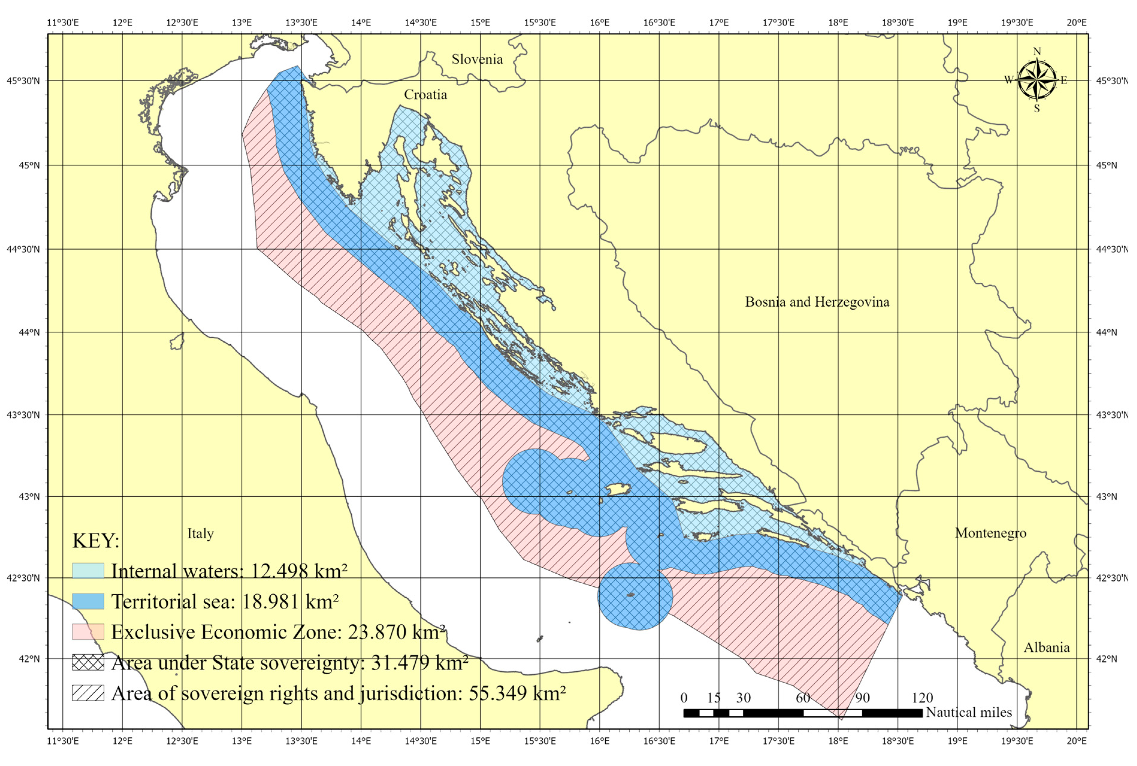
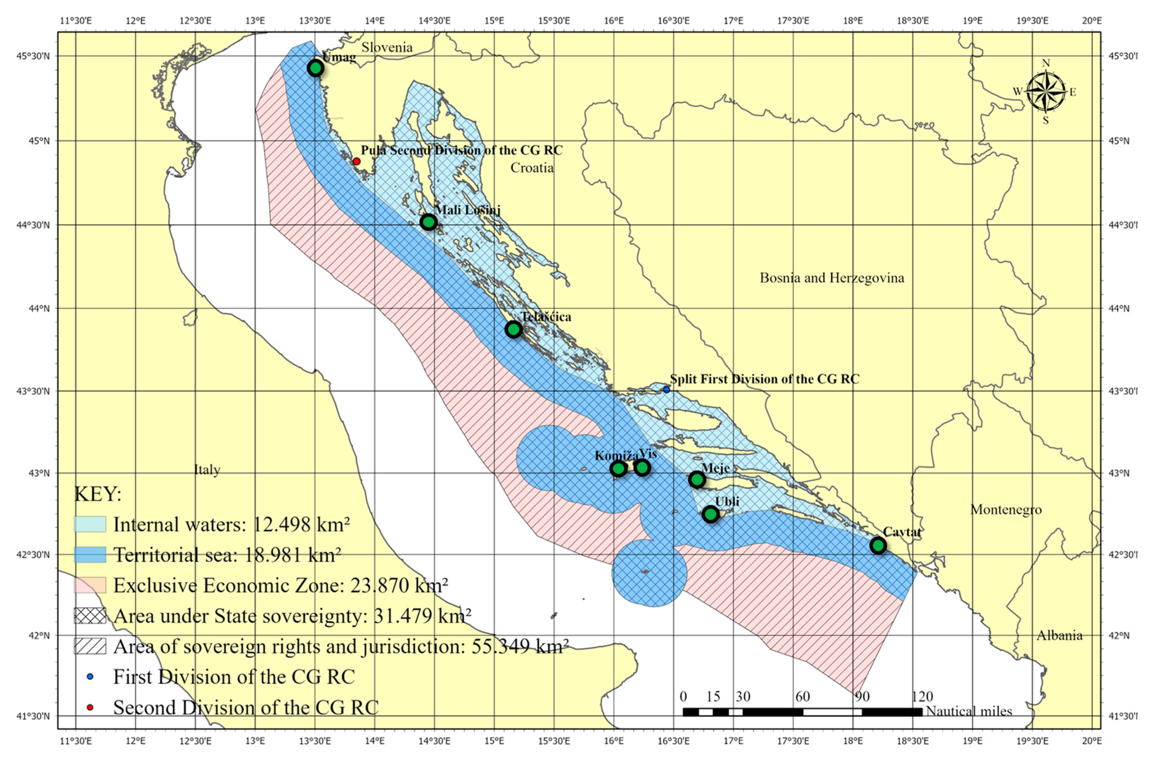
The resources of the Croatian Coast Guard include mobile and stationary units: ships and boats, airplanes, helicopters, systems of unmanned aerial vehicles, floating and anchored objects, and other means and equipment [23]. The operations of the CGRC are carried out through the operational maritime and air forces of the first and second divisions. The first division of the CGRC has its operational and logistical headquarters in the “Admiral of the Fleet Sveto Letica-Barba” barracks in Split. In 2014, the second division of the Croatian Coast Guard was relocated from the “Admiral of the Fleet Sveto Letica-Barba” barracks in Split to the “Vargarola” barracks in Pula, which increased the operational capabilities of the CGRC in carrying out its basic tasks. Figure 1 shows the areas of sovereignty, sovereign rights, and jurisdiction of the Republic of Croatia in the Adriatic Sea—eastern part, with the geographic positions of the NATO naval base of the Croatian Navy, including the naval bases of the CGRC.

Figure 1.
Sea and sub-sea areas of the Republic of Croatia in the Adriatic Sea.
Figure 1 clearly shows that the Republic of Croatia has one of the longest and the most indented coastlines in the world, consisting of 1700 km of mainland coastline and another 4000 km of coastline of 1200 islands and islets. This poses a major challenge for maritime safety and environmental protection. The number of Maritime Police and Coast Guard resources needed to secure such a coastline can be enormous, if they are not distributed optimally.
Therefore, this research proposed the multi-criteria analysis (MCA) model and the criteria set to evaluate and rank the potential maritime locations that could be used for the deployment of the Coast Guard resources, i.e., the maritime locations that can be developed into the Coast Guard homeports. The Materials and Methods Section describes the definition of the criteria set and the criteria weights defined by 60 experts using a questionnaire. Additionally, the PROMETHEE method, which is used for the MCA model, is presented with its advantages and disadvantages in comparison to another MCA model. The Results Section consists of the case study of eastern Adriatic Sea with real-world maritime locations and data that were used to test the proposed MCA model. The Discussion and Conclusions Sections show how the proposed MCA model can improve the strategic planning of the Coast Guard resource deployment to increase sustainability, safety, and security in the eastern Adriatic Sea.
2. Materials and Methods
This research deals with a multi-criteria problem that needs to be addressed using some of the mathematical multi-criteria decision-making methods. Namely, the Coast Guard has the challenge of securing the state border at sea and also protecting the territorial sea against oil pollution, criminal activities and piracy, drug smuggling, illegal immigrants’ transportation, etc. All this makes improving the distribution of Coast Guard resources more important and more difficult. Additionally, many criteria must be considered when deciding about Coast Guard homeport locations, thus making it a multi-criteria problem. The first task was to define a criteria set for analyzing potential maritime locations that could become Coast Guard homeports. Based on the literature analysis of the conceptual definition of the Coast Guard [13,14,15,20,21], the specific challenges for the CGRC [18,19], and the authors’ personal experience, 7 criteria groups were defined (A, B, C, D, E, F, G), consisting of 20 criteria (Table 2).
Table 2.
Criteria information and description.
The next step was to validate this criteria set and to determine criteria weights. For that purpose, an online questionnaire was made to interview the maritime and Coast Guard experts.
2.1. Questionnaire for Maritime and Coast Guard Experts
The aim of the questionnaire was to determine the weighting of the criteria, as these have the greatest influence on the decision-making process, particularly in some multi-criteria analysis methods. Additionally, the questionnaire was used to validate the criteria set by the experts. The metadata of the questionnaire are shown in Table 3.
Table 3.
The questionnaire metadata.
The results of the questionnaire helped to determine the weighting of the criteria. Each expert was asked to rate the weighting of each set of criteria and each criterion on a scale of 0 to 100 points. The experts were not asked to normalize their weights; this was performed in an analysis after the questionnaire. Since the PROMETHEE method was planned to be used in this research, it was not necessary to normalize the weights. Namely, one of the steps of the PROMETHEE method is weight normalization. However, for a case with lot of criteria groups and criteria, like this one, it is much easier to understand the weights if they are normalized.
Finally, the mean values of the normalized criteria weights were calculated with the standard deviation of the values for 20 criteria in the 7 criteria groups (Figure 2). None of the experts had any remarks on the criteria set; all 20 criteria were accepted by the experts. In addition, the calculated criteria weights represent an important input for the MCA.
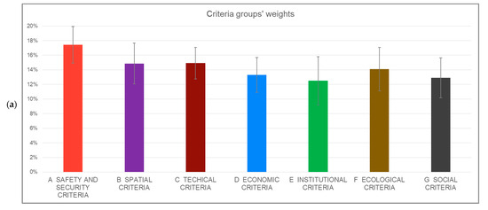
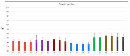
Figure 2.
The criteria weights determined by the experts (with standard deviation marks): (a) criteria groups’ weights and (b) criteria weights.
2.2. Multi-Criteria Analysis
Many methods of multi-criteria analysis (MCA) and multi-criteria decision-making (MCDM) are used in the scientific community [24]: AHP, TOPSIS, PROMETHEE, ELECTRE, VIKOR, MAUT, MACBETH, SAW, etc. All of them can handle multiple criteria, but some of them are limited to qualitative criteria only, and some of them use both quantitative and qualitative criteria. Three of these methods are the most widely used according to the scientific databases Scopus and Current Contents [24]: the Analytic Hierarchy Process (AHP) [25], the TOPSIS (Technique for Order of Preference by Similarity to Ideal Solution) method [26], and PROMETHEE (Preference Ranking Organization METHod for Enrichment of Evaluations) [27]. These three methods can be applied to almost any kind of multi-criteria decision-making problem, particularly AHP and PROMETHEE that belong to the family of outranking methods [28]. Nevertheless, these methods have also found applications in support of sustainable development and marine environmental protection.
Gazos and Vagiona [29] used the AHP method to assess the maritime suitability of the offshore wind farms. Hassan et al. [30] used the TOPSIS method to address the problem of optimum site selection for solar photovoltaic farms. Rehman [31] used the PROMETHEE method and the Visual PROMETHEE software (version 1.4) to evaluate solar panel cooling systems. Rogulj et al. [32] used the Fuzzy-logic-based PROMETHEE method to optimize plans for flat roof renovations. Mladineo et al. [3,33] used the PROMETHEE-method-based decision support system to enhance the solving of crisis situations in maritime traffic. In all these examples of application, the AHP, TOPSIS, and PROMETHEE methods successfully combine qualitative and quantitative criteria of completely different kinds: economic, environmental, technical, social, etc.
Uzun et al. [9] used the AHP method to determine the distribution of the Coast Guard vessels. As mentioned earlier, research by Uzun et al. is the closest to the model presented in this research. However, Uzun et al. aimed to improve the spatial distribution of the Coast Guard vessels in already existing homeports, but this research is dealing with the spatial distribution of Coast Guard homeports, which precedes the distribution of the vessels.
In this research, the third most popular MCA/MCDM method [24] was selected to improve the Coast Guard resource deployment: the PROMETHEE method. It has been chosen because of its visualization abilities (PROMETHEE Diamond, GAIA, and similar) and because it is especially recommended for analysis with different kinds of criteria [34,35]. The TOPSIS method was not selected, because the criteria evaluation normalization methodology that it uses is too simple and sometimes results in the non-realistic ranking of alternatives [24]. The most popular method—the AHP method—was also not selected as it has been criticized by the scientific community regarding its mathematical and logical consistency [36]. There is still an active debate among scientists about the AHP method, with some scientists criticizing it [34] and others supporting it [37]. On the other hand, there are no such a critics of the PROMETHEE method. Yet, there are some issues of the PROMETHEE method that could be seen as its disadvantages. The PROMETHEE method belongs to the class of outranking methods, like AHP and ELECTREE, which are based on pairwise comparisons of alternatives. This pairwise comparison of alternatives results in the ranking of alternatives from the best to the worst. However, the ranking is a relative fact; it says nothing about the quality of the alternatives. For example, if all the very poor alternatives were included in the ranking, it would mean that the best-ranked alternative is actually the least-poor alternative [38], and vice versa if all the excellent alternatives were included in the ranking, it would mean that the last-ranked alternative is the least-excellent alternative. This issue can be solved by introducing additional alternatives that serve as reference points [38], and this procedure can be seen as a validation of the PROMETHEE ranking. In this research, this type of validation is planned as a future work.
2.3. Improvement of the Coast Guard Resource Deployment by Using the PROMETHEE Method
The PROMETHEE method was developed by Brans and Mareschal in 1983 [27]. The input for the PROMETHEE method is a matrix consisting of a set of actions (alternatives) A, where each a element of A has its f(a), which represents the evaluation of one criterion for action a. The PROMETHEE method consists of two steps: PROMETHEE I and PROMETHEE II. The PROMETHEE I method ranks the actions using partial ranking, consisting of the positive outranking flow [27]:
and the negative outranking flow [27]:
where a and b represent the actions from a set of actions A (during the pairwise comparison of action a with all other n − 1 actions), n is the number of actions, and Π is the aggregated preference index defined for each couple of actions.
The PROMETHEE I method provides the partial relation, and then a net outranking flow is obtained from the PROMETHEE II method, which ranks the actions by a complete ranking, and calculates the net flow [27]:
In addition, the criteria are weighted using criteria weights wj and the common pondering technique [27]:
where Pj(a,b) represents the preference of a over b for a given preference function of criterion j. There are six different types of preference functions. In this research, the linear preference function with a preference threshold (V-shape function) has been used.
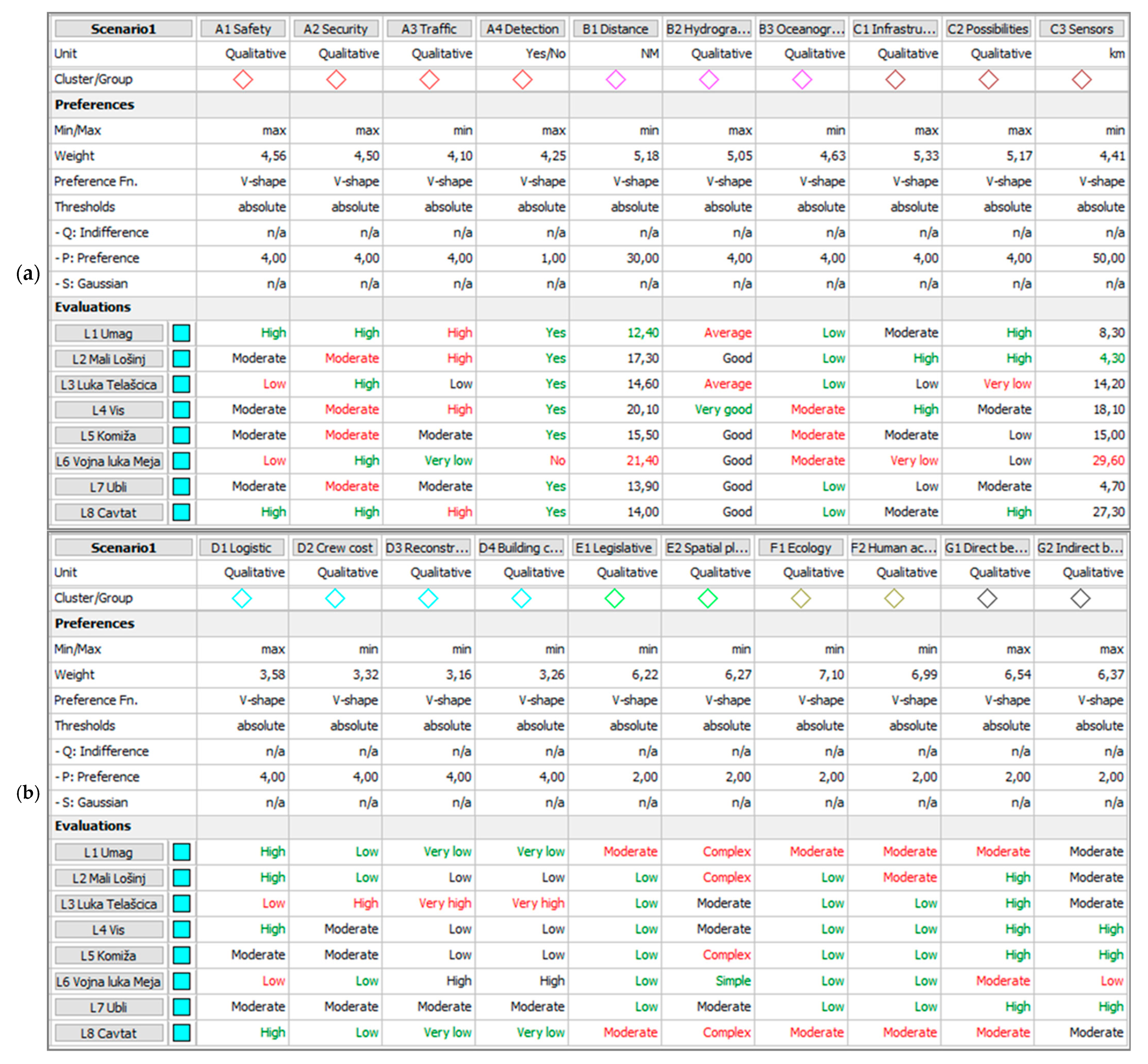
The Coast Guard resource deployment problem addressed in this research consists of 8 alternatives (actions) and 20 criteria (divided into 7 criteria groups). At the moment, all CGRC resources are deployed at the military port “Admiral of the Fleet Sveto Letica-Barba” in Split (the first division of the CGRC) and the military port “Vargarola” in Pula (the second division of the CGRC). The 8 alternatives represent 8 new maritime locations that could become new homeports for the Coast Guard. Most of them are civilian locations and some of them already belong to the Croatian Navy. These 8 maritime locations are particularly interesting because they are geographically close or very close to the state border at sea (Figure 3).

Figure 3.
Geographic map of 8 new maritime locations (green dots).
The input matrix for the PROMETHEE method consists of criteria data—criteria weights and criteria preference function type and parameters—and criteria evaluations for each alternative. Two criteria are quantitative, and eighteen criteria are qualitative, using the 2-point, 3-point, or 5-point Likert scale (Table 2). All these data were modeled in the “Visual PROMETHEE” software (version 1.4) which was used for MCA in this research (Figure 4).

Figure 4.
The input matrix with alternatives and criteria data: (a) safety and security, spatial, and technical criteria and (b) economic, institutional, ecological, and social criteria.
3. Results
The Coast Guard resource deployment problem shown in the input matrix (Figure 4) was submitted to the PROMETHEE I and PROMETHEE II methods by using the “Visual PROMETHEE” software (version 1.4). The results of the PROMETHEE II method are given in Table 4 and Figure 5.
Table 4.
The results of the PROMETHEE II method (complete ranking).

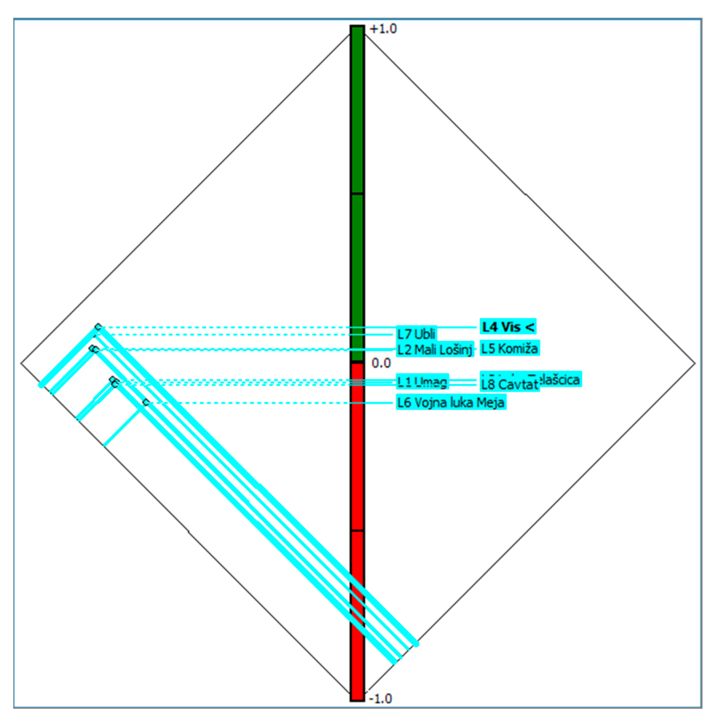
Figure 5.
The results of the PROMETHEE II method presented in PROMETHEE Diamond (complete ranking).
The first-ranked alternative, with the highest PROMETHEE II net flow, is maritime location “L4 Vis” (Table 4 and Figure 5). However, the second-ranked alternative, “L7 Ubli”, has only a bit lower net flow. These two alternatives form a kind of cluster. The second cluster is the third- and fourth-ranked alternatives “L5 Komiža” and “L2 Mali Lošinj”. The next cluster consists of “L3 Luka Telašćica”, “L1 Umag”, and “L8 Cavtat”, which rank fifth, sixth, and seventh. And the last-ranked alternative is “L6 Vojna luka Meja”. The last four ranked alternatives have a negative net flow, which means that they were outranked by other alternatives in most of the criteria.
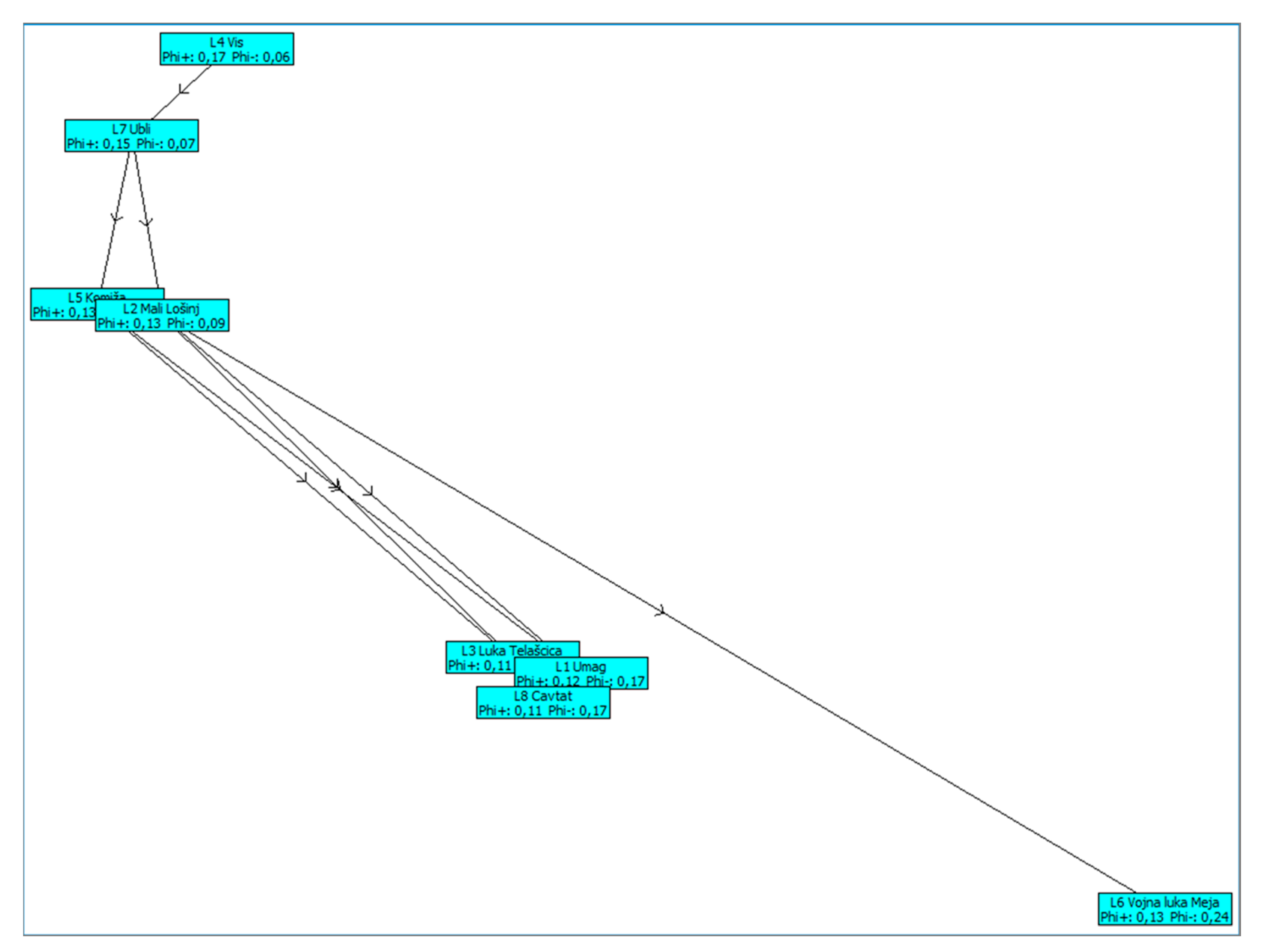
The so-called clusters of the alternatives are even more visible in the visualization of the PROMETHEE I method partial ranking (Figure 6). It is clear that the first- and second-ranked alternatives, “L4 Vis” and “L7 Ubli”, dominate above all the other alternatives. The next two alternatives are not easy to compare mutually, because “L2 Mali Lošinj” has a higher PROMETHEE I positive flow (i.e., how good was this alternative compared to all the alternatives worse than itself) than “L5 Komiža”, but it has a lower rank, and because “L2 Mali Lošinj” has a higher PROMETHEE I negative flow (i.e., how bad was this alternative in comparison with the alternatives better than itself) than “L5 Komiža”. These two alternatives are therefore not fully comparable. However, the PROMETHEE II net flow is used as a compromise solution to mutually compare all alternatives, including the non-comparable ones.

Figure 6.
The results of the PROMETHEE I method (partial ranking).
4. Discussion and Conclusions
The PROMETHEE ranking of the proposed maritime locations must be further analyzed and the practical implications of the ranking need to be explained. The additional analysis provided by the PROMETHEE method is the GAIA plot. The problem of the Coast Guard resource deployment is very complex because it consists of 20 criteria. Each criterion represents one dimension, thus resulting in a 20-dimensional space that is unimaginably large. Therefore, the GAIA plot projects the n-dimensional space onto a 2-dimensional plate to allow for additional analysis of the problem. The GAIA plot for this problem is presented in Figure 7.
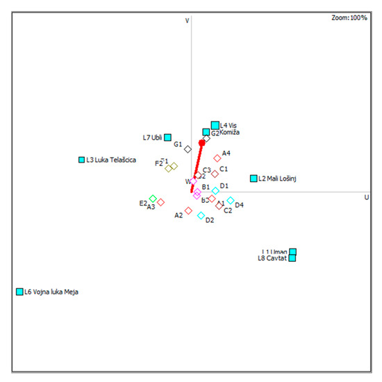
Figure 7.
The results of the PROMETHEE II method presented in a GAIA plot.
The GAIA plot contains a red vector pointing into some direction. The alternatives which are positioned in that direction are the highest-ranked alternatives. For instance, alternative “L6 Vojna luka Meja” is in the completely opposite direction and is therefore the worst-evaluated alternative. The directions of all criteria (A1, A2, A3, etc.) are also scattered, which shows how complex this problem is.
The conflicting criteria and variety of alternatives made this Coast Guard resource deployment problem very complex. However, the criteria defined by the experts and their weighting enabled a successful evaluation and ranking of the eight proposed maritime sites.
Nevertheless, after the initial ranking (PROMETHEE) and further analysis (GAIA), the practical significance of the ranking of maritime locations must be explained. The geographical map of the eight new maritime locations and their ranks (Figure 8) represents a product for the Government and military stakeholders to enhance their decision-making regarding the future development of the Coast Guard. The resulting ranks are suggesting which maritime locations are the priorities for investment and development into Coast Guard homeports to improve the spatial distribution of the Coast Guard resources. For example, the top three ranked locations are very close to each other. Not all of them need to be selected as the Coast Guard’s new homeport, but it is not out of the question. These three sites have different oceanographic characteristics that make it possible to establish at least one operational homeport under all meteorological conditions. However, additional data are needed to better plan strategic development. For example, the costs for reconstruction, personnel, maintenance, and development in this example are qualitative values. If they become quantitative values, a budget could be set for the development of the Coast Guard’s homeports. Using the PROMETHEE V method [39], an optimal usage of the budget could be achieved by selecting some of the maritime locations among the eight of them. It is something that belongs to future work.

Figure 8.
Geographic map of 8 new maritime locations (green dots) and their ranks.
The new Coast Guard homeports would allow for better responsiveness in the case of maritime accidents, surveillance of the state border at sea, interventions in the case of oil pollution or in the case of migrant vessels, etc. All this increases maritime traffic safety and marine environment protection, thus enabling the sustainable development of all kinds of maritime activities. From an economic point of view, the most important maritime activities in the Republic of Croatia are nautical tourism and fishery. Both of these activities require a clean and non-polluted sea, thus making sustainable development an imperative.
Additionally, future research should focus on the application of this model in a different case study, i.e., in a different semi-enclosed sea. The limitation of the developed model lies in its application to the coastal state with a specific semi-enclosed sea. However, there are other states that share the same semi-enclosed sea (Italy, Albania, etc.) and perhaps a very similar model could be applied in these states. Nevertheless, the PROMETHEE method allows for the easy addition and removal of criteria, so the model could probably be adapted for some specific and different geographic areas, as well.
Furthermore, the developed model could be further validated by testing it on existing Coast Guard ports (Split and Rijeka) that could serve as some kind of reference points. These reference points could be used for additional validation of the ranking of the proposed maritime locations. Nevertheless, the use of another similar MCA method, instead of PROMETHEE, could also be considered.
Author Contributions
Conceptualization, T.S., M.M., M.K., and T.M.; methodology, T.S., M.M., and M.K.; software, T.S. and M.M.; validation, T.S., M.M., M.K., and T.M.; writing—original draft preparation, T.S. and M.M.; writing—review and editing, T.S., M.M., M.K., and T.M.; supervision, M.K. All authors have read and agreed to the published version of the manuscript.
Funding
Author Toni Mišković was employed by the company OIV—Transmitters and Communications Ltd. The company was not involved in the study design, collection, analysis, interpretation of data, the writing of this article or the decision to submit it for publication.
Institutional Review Board Statement
Not applicable.
Informed Consent Statement
Not applicable.
Data Availability Statement
Data are contained within the article.
Conflicts of Interest
Author Toni Mišković was employed by the company OIV—Transmitters and Communications Ltd. The remaining authors declare that the research was conducted in the absence of any commercial or financial relationships that could be construed as a potential conflict of interest.
References
- Kim, H.; Koo, K.; Lim, H.; Kwon, S.; Lee, Y. Analysis of Fishing Vessel Accidents and Suggestions for Safety Policy in South Korea from 2018 to 2022. Sustainability 2024, 16, 3537. [Google Scholar] [CrossRef]
- Dupont, C.; Gourmelon, F.; Meur-Ferec, C.; Herpers, F.; Le Visage, C. Exploring uses of maritime surveillance data for marine spatial planning: A review of scientific literature. Mar. Policy 2020, 117, 103930. [Google Scholar] [CrossRef]
- Mladineo, N.; Mladineo, M.; Knezic, S. Web MCA-based Decision Support System for Incident Situations in Maritime Traffic: Case Study of Adriatic Sea. J. Navig. 2017, 70, 1312–1334. [Google Scholar] [CrossRef]
- Li, C.; Yang, Y.; Yang, X.; Chu, D.; Cao, W. A Novel Multi-Scale Feature Map Fusion for Oil Spill Detection of SAR Remote Sensing. Remote Sens. 2024, 16, 1684. [Google Scholar] [CrossRef]
- Vives, L. Unwanted sea migrants across the EU border: The Canary Islands. Political Geogr. 2017, 61, 181–192. [Google Scholar] [CrossRef]
- Puspita, A.; Wiranto, S.; Rudiyanto, R.; Widodo, P.; Saragih, H.J.R. The Effectiveness of Maritime Surveillance to Handling Drug Smuggling by Sea in Banten Province. Int. J. Soc. Sci. Res. Rev. 2023, 6, 52–63. [Google Scholar]
- Urlić, A. Positioning of the Coast Guard of the Republic of Croatia. Hrvat. Vojn. 2010, 291, 22–27. [Google Scholar]
- Zekić, A.; Luttenberger, A. Contribution of maritime spatial planning to protection of the marine environment. Pomor. Zb.—Spec. Ed. 2016, 1, 283–296. [Google Scholar]
- Uzun, G.; Dağdeviren, M.; Kabak, M. Determining the Distribution of Coast Guard Vessels. Interfaces 2016, 46, 297–314. [Google Scholar] [CrossRef]
- Sunko, T. Optimisation of the Coast Guard Resource Deployment in Semi-Enclosed Seas as a Function of the National Security. Ph.D. Thesis, University of Rijeka, Rijeka, Croatia, June 2024. [Google Scholar]
- Coast Guard. Available online: https://www.britannica.com/topic/coast-guard (accessed on 17 May 2024).
- Obalna Straža. Available online: https://www.enciklopedija.hr/clanak/obalna-straza (accessed on 17 May 2024).
- Gimblett, R.H.; Lindberg, M.; Todd, D. Brown-, Green- and Blue-Water Fleets: The Influence of Geography on Naval Warfare, 1861 to the Present. Nav. War Coll. Rev. 2003, 56, 19. [Google Scholar]
- Luburić, D. Coast Guards in the world. Naše More 1998, 45, 185–189. [Google Scholar]
- Nimac, K. Concept and organization of the Coast Guards in the world with reference to USCG. Zb. Rad. Veleučilišta U Šibeniku 2014, 1–2, 155–167. [Google Scholar]
- National Security of the Republic of Croatia and Project of the Border and Coast Guard. Available online: https://obris.org/hrvatska/nacionalna-sigurnost-rh-i-projekt-granicne-i-obalne-straze-eu (accessed on 29 May 2024).
- Haines, S. War at sea: Nineteenth-century laws for twenty-first century wars? Int. Rev. Red Cross 2016, 98, 419–447. [Google Scholar] [CrossRef]
- The Coast Guard of Republic of Croatia—Legislative Framework. Available online: https://hrcak.srce.hr/file/280403 (accessed on 29 May 2024).
- Kardum, Z. Zaštita interesa Republike Hrvatske na Jadranu. Hrvat. Vojn. 2003, 100, 6–8. [Google Scholar]
- Bowers, I.; Koh, S.L.C. Grey and White Hulls: An International Analysis of the Navy-Coastguard Nexus. Contemp. Southeast Asia 2020, 42, 132–134. [Google Scholar]
- Mohamed, A.M. What Is a Coast Guard? Developing a Nomenclature Model for Coast Guard. Master’s Thesis, Naval Postgraduate School, Monterey, CA, USA, June 2022. [Google Scholar]
- The Global Navy/Coast Guard Relationship: A Mandate-Based Typology. 2010. Available online: https://www.navalreview.ca/2011/12/gillis-global-navy-coast-guard-relationship-paper-now-available-on-line (accessed on 2 September 2023).
- Act on the Coast Guard of the Republic of Croatia (109/07, 125/19). Available online: https://narodne-novine.nn.hr/clanci/sluzbeni/2019_12_125_2487.html (accessed on 3 June 2024).
- Veza, I.; Mladineo, M.; Kutlesa, M.; Gjeldum, N.; Bilic, B.; Crnjac Zizic, M.; Aljinovic, A.; Basic, A. Selection of the Cobot Workstation for the Learning Factory by Using the Multi-Criteria Analysis. Proc. 12th Conf. Learn. Factories (CLF 2022) 2022, 1, 4072387. [Google Scholar] [CrossRef]
- Saaty, T.L. The Analytic Hierarchy Process: Planning, Priority Setting, Resource Allocation; McGraw Hill: New York, NY, USA, 1980. [Google Scholar]
- Lai, Y.J.; Liu, T.Y.; Hwang, C.L. TOPSIS for MODM. Eur. J. Oper. Res. 1994, 76, 486–500. [Google Scholar] [CrossRef]
- Brans, J.P.; Vincke, P.; Mareschal, B. How to select and how to rank projects: The Promethee method. Eur. J. Oper. Res. 1986, 24, 228–238. [Google Scholar] [CrossRef]
- Roy, B. Classement et choix en présence de points de vue multiples (la méthode ELECTRE). La Rev. D’informatique Et De Rech. Opérationelle (RIRO) 1968, 8, 57–75. [Google Scholar]
- Gazos, K.; Vagiona, D.G. Marine Suitability Assessment for Offshore Wind Farms’ Deployment in Thrace, Greece. Sustainability 2024, 16, 4204. [Google Scholar] [CrossRef]
- Hassan, I.; Alhamrouni, I.; Azhan, N.H. A CRITIC–TOPSIS Multi-Criteria Decision-Making Approach for Optimum Site Selection for Solar PV Farm. Energies 2023, 16, 4245. [Google Scholar] [CrossRef]
- Rehman, A.U. Solar Panel Cooling System Evaluation: Visual PROMETHEE Multi-Criteria Decision-Making Approach. Sustainability 2023, 15, 12947. [Google Scholar] [CrossRef]
- Rogulj, K.; Jajac, N.; Batinić, K. Flat Roofs Renovation Planning on Public Buildings Using Fuzzy Multi-Criteria Analysis. Sustainability 2023, 15, 6280. [Google Scholar] [CrossRef]
- Mladineo, N.; Jajac, N.; Mladineo, M. Application of GIS and mathematical modeling in maritime crisis situations. Croat. Oper. Res. Rev. 2010, 1, 83–92. [Google Scholar]
- Nemery, P. On the Use of Multicriteria Ranking Methods in Sorting Problems. Ph.D. Thesis, Université Libre de Bruxelles, Brussels, Belgium, November 2008. [Google Scholar]
- Guitouni, A.; Martel, J.M. Tentative guidelines to help choosing an appropriate MCDA method. Eur. J. Oper. Res. 1998, 2, 501–521. [Google Scholar] [CrossRef]
- Dyer, J.S. Remarks on the Analytic Hierarchy Process. Manag. Sci. 1990, 36, 249–258. [Google Scholar] [CrossRef]
- Whitaker, R. Criticisms of the Analytic Hierarchy Process: Why they often make no sense. Math. Comput. Model. 2007, 46, 948–961. [Google Scholar] [CrossRef]
- Mladineo, M.; Celar, S.; Celent, L.; Crnjac, M. Selecting Manufacturing Partners in Push and Pull-Type Smart Collaborative Networks. Adv. Eng. Inform. 2018, 38, 291–305. [Google Scholar] [CrossRef]
- Brans, J.P.; Mareschal, B. PROMETHEE V: MCDM problems with segmentation constraints. INFOR Inf. Syst. Oper. Res. 1992, 2, 85–96. [Google Scholar] [CrossRef]


Disclaimer/Publisher’s Note: The statements, opinions and data contained in all publications are solely those of the individual author(s) and contributor(s) and not of MDPI and/or the editor(s). MDPI and/or the editor(s) disclaim responsibility for any injury to people or property resulting from any ideas, methods, instructions or products referred to in the content. |
© 2024 by the authors. Licensee MDPI, Basel, Switzerland. This article is an open access article distributed under the terms and conditions of the Creative Commons Attribution (CC BY) license (https://creativecommons.org/licenses/by/4.0/).