Article

Evaluation of Geoenvironment Carrying Capacity in Mineral Resource-Based Cities from the Perspective of Sustainable Development

1
School of Civil Engineering and Mechanics, Lanzhou University, Lanzhou 730000, China
2
Liaoning Tenth Geological Brigade Limited Liability Company, Fushun 113004, China
*
Author to whom correspondence should be addressed.
Sustainability 2024, 16(18), 7934; https://doi.org/10.3390/su16187934
Submission received: 16 June 2024 / Revised: 22 August 2024 / Accepted: 8 September 2024 / Published: 11 September 2024
(This article belongs to the Special Issue Geological Engineering and Sustainable Environment)

Abstract

:
The exploitation of natural resources and the degradation of the geological environment pose dual challenges for mineral resource-based cities amidst rapid economic development and urbanization. Evaluating geoenvironmental carrying capacity is essential in measuring the harmony between human activities and the geological environment. Unfortunately, current evaluation methods do not adequately capture the intricate interplay of multiple factors, hindering a comprehensive understanding of this concept in mineral resource cities. To address this gap, this study integrates the DPSR model into the assessment of geoenvironmental carrying capacity, aligning with the characteristics and sustainable development objectives of these cities. By employing catastrophe theory, entropy method, and analytic hierarchy process, a robust evaluation index system specific to mineral resource cities is established. Using Fushun City in Liaoning Province, China, as a case study, the analysis reveals consistently high comprehensive evaluation values over the past five years, reflecting the city’s actual environmental status. The research highlights enhancing the response layer as a key strategy to boost regional geoenvironmental carrying capacity. These results offer valuable insights for the planning of mineral resource cities, fostering regional sustainable development, and promoting geological environmental protection.

1. Introduction

The geological environment, as an integral component of the natural world, is not only a valuable natural resource but also serves as the foundation and necessary conditions for the sustainable development of human society [1]. Human activities are contingent upon specific resources and environments, with the geological environment playing a particularly pivotal role in the sustainable development of cities [2]. In recent years, the rapid expansion of China’s economy and urbanization has heightened the stark contrast between social development and natural resource conservation [3]. Particularly noteworthy is the development of mineral resource-based cities in the northeast of China, an area rich in mineral resources. This has resulted in the establishment of numerous mineral resource-based cities that have provided a solid material foundation for China’s industrialization and modernization [4]. However, the exploitation and utilization of these resources have led to the gradual deterioration of the geoenvironment, causing issues such as decreased geoenvironment carrying capacity and triggering geologic disasters like landslides and collapses. These incidents have not only significantly impacted the quality of life for residents but also posed a formidable challenge to the long-term sustainability of urban areas. The geological environment, considered an integral component of the natural world, is not only a valuable natural resource but also plays a crucial role in the sustainable development of human society [5]. Human activities are heavily reliant on specific resources and environments, with the geological environment assuming a particularly pivotal role in the sustainable development of cities. Recognizing this challenge, in 2013, the State Council released the National Plan for the Sustainable Development of Resource-Based Cities, outlining a framework for sustainable development planning and resource utilization in mineral resource-based cities from 2013 to 2020 [6]. Consequently, the sustainable utilization of the geoenvironment has become a pressing issue, prompting a focus on the study of geoenvironmental carrying capacity due to its fundamental importance. The evaluation of geoenvironmental carrying capacity is considered crucial for identifying a sustainable development trajectory for the region, emphasizing the necessity for resolution in this area [7,8].
The term “geoenvironmental carrying capacity” underscores the interrelationship between human production, life, and the geoenvironment, referring to the ability of the geoenvironment to support life and development [9]. This capacity is influenced by several factors, which are often complex, ambiguous, and uncertain [10]. It is a pervasive concept in the research of sustainable utilization of natural resources and sustainable development of environmental systems, in conjunction with the notions of resource environmental carrying capacity and ecological environment carrying capacity [11,12].
The study of geoenvironment carrying capacity has evolved, transitioning from a theoretical concept to a practical application and from examining single factors to conducting a comprehensive evaluation [13]. This comprehensive evaluation approach, which emphasizes regional characteristics and holistic perspectives, has emerged as a crucial criterion for assessing the sustainable development of a given region [8,14]. In their study, Xi et al. developed a geoenvironment carrying capacity evaluation system for Huangshi City in Hubei Province. The evaluation system comprised three main aspects: geological environment, ecological environment, and social environment. Each aspect was quantified through cloud modeling to enhance hierarchical analysis (AHP) and fuzzy function methods. The findings indicated a favorable overall condition of the geoenvironment carrying capacity in Huangshi City [15].
On the other hand, Wu et al. conducted a case study in Tonghua City, focusing on three key perspectives: ecological and geological background, human activities, and mining engineering activities. Environmental pollution was also considered in their evaluation. By employing game theory, the network analysis method (ANP-CV), and the coefficient of variation method, they conducted a comprehensive assessment of the geoenvironment. Subsequently, the researchers categorized the region based on geological environmental quality levels within the mining area [16]. Qi et al. conducted a comprehensive evaluation of the geoenvironment carrying capacity of Erdaojiang District and Dongchang District in Tonghua City, Jilin Province. By focusing on the geoenvironment, ecological environment, and social environment, they utilized hierarchical analysis, the CRITIC method, and game theory. The results indicated that the research area exhibited a generally superior geoenvironment carrying capacity [17].
In contrast, Wang et al. attempted to address deficiencies in prior research on regional geoenvironment carrying capacity by merging the intuition fuzzy and TOPSIS models. Their study established an evaluation index system to examine the spatial variations in geoenvironment carrying capacity. Wang et al. findings revealed substantial differences across different areas [18]. Furthermore, Yao et al. developed an assessment index system for geoenvironment carrying capacity, focusing on resources, environment, regulation, and socioeconomics. They applied the entropy value–AHP method of the set-pair analysis model to assess the geoenvironment carrying capacity of Daqing City. Their study highlighted the poor geoenvironment carrying capacity in Zhaozhou and Zhaoyuan, indicating the urgent need for protection [19].
A paucity of studies has analyzed the factors affecting geoenvironment carrying capacity or explored the nature of geoenvironment carrying capacity. However, most current studies focus on the selection of evaluation factors or improvement of methods, while the evaluation process is somewhat subjective, and the correlation between factors and evaluation results is not strong. It is crucial to investigate the intricate interrelationship between the economy, resources, and the geoenvironment for mineral resource-based cities, which are dependent on resources, to elucidate the underlying causes of geoenvironment carrying capacity. To address this issue, a framework for evaluating the geoenvironment carrying capacity of mineral resource-based cities is proposed from a sustainable development perspective. The geoenvironment carrying capacity of Fushun City is evaluated using the Driver–Pressure–State–Response (DPSR) model, which is combined with catastrophe theory, the entropy method, and hierarchical process analysis. The results of the evaluation are utilized to identify the primary factors influencing the geoenvironment carrying capacity of the area, and these findings are then used to suggest potential solutions and recommendations for future improvements. The objective of this study is to offer new insights and methodological guidance for evaluating the geoenvironment carrying capacity of mineral resource-based cities and to provide information that can inform regional economic development and resource allocation in Fushun City.

2. Materials and Methods
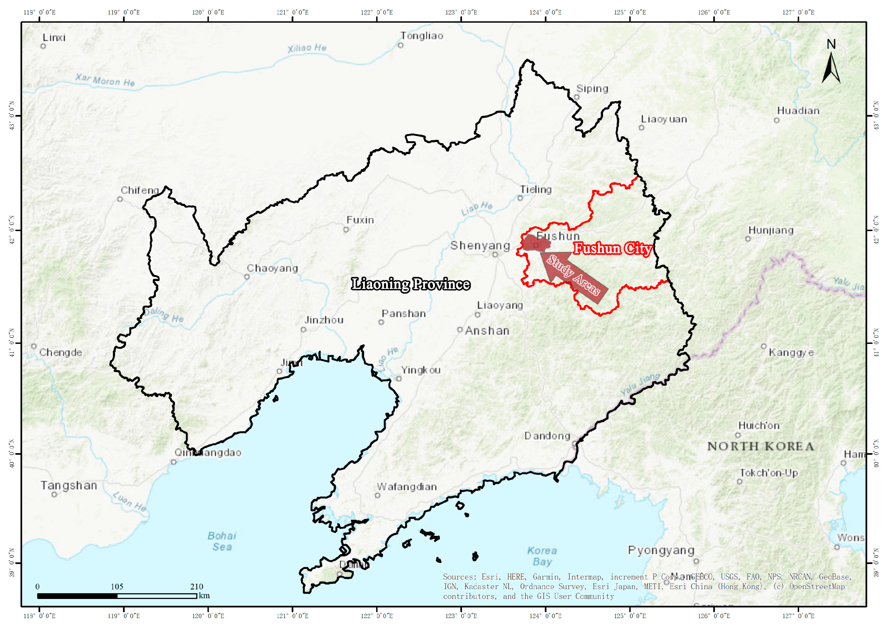
2.1. Study Area

Fushun City is located in the east part of Liaoning Province, 48 km from Shenyang (Figure 1). The geographical coordinates lie roughly at a longitude of 123°39′ to 125°280′ and an altitude of 41°38′ to 42°14′. The urban area is 713.6 km2. The city’s total population is 2.25 million people, including an urban population of 1.42 million people [20].
Fushun City, a municipality that revolved around the mining sector, houses coal mines that have been actively operating since 1901, boasting a historical legacy spanning more than a century. This historical backdrop has precipitated a distinctive urban morphology characterized by a juxtaposition of industrial mines within the cityscape and the emergence of novel urban infrastructures interspersed among them [21]. However, the sustained mining engineering practices have precipitated the deterioration of Fushun City’s original geological terrain, culminating in urban geologic calamities, including widespread ground subsidence, fissures, and landslides [22,23]. These adversities exert a profound impact on the denizens and commercial entities within the municipality. Given the prevailing lack of comprehensive insights into the constraints that govern the geological setting of Fushun City, there looms a palpable threat to the enduring viability of both its economic trajectory and geological stability [24]. Thus, it is imperative to conduct in-depth evaluations of the geoenvironmental carrying capacity to avert calamities, secure public safety, safeguard geologic assets, and fortify the sustainable progression of the local economy.

2.2. Investigative Framework

In the context of sustainable development, the extent to which the geoenvironment carrying capacity is influenced by a multitude of factors is evaluated through the application of mutation theory, the entropy method, and the Analytic Hierarchy Process (AHP) DPSR for the intricate interrelationship between resources, economy, and geoenvironment in mineral resource-based cities. The general framework of this study is depicted in Figure 2.
To ensure the objectivity of the evaluation, the entropy value method is first applied to rank the importance of the indicators. This is followed by the utilization of the mutation theory to determine the value of the system’s mutation subordinate function. Finally, the region’s geoenvironment carrying capacity is determined according to the established indicator system and evaluation level.
The entropy value method defines the weight of each indicator in the decision-making process according to the amount of information obtained from each indicator. This method effectively avoids the interference of human factors, thereby ensuring the objectivity and realism of the evaluation results.
  • Data preprocessing;
Standardization is a pivotal element in multi-criteria analysis, as it ensures that all indicators are given equal weighting, irrespective of their original units or scales. This process prevents any single indicator, particularly those with larger values, from dominating the analysis, thereby maintaining a fair and unbiased assessment. Furthermore, by converting data to a common scale, standardization enhances comparability, enabling meaningful comparisons between different indicators and evaluation objects. To ensure consistency in the impact factors, it is advisable to standardize them by converting the absolute value of each indicator into its corresponding numerical value.
Formula (1) is employed to standardize positive indicators. The original data of a positive indicator is transformed into a standardized value that optimizes its potential. The formula is typically expressed as follows:
X i j = X i j X j , min X j , max X j , min + 0.000001 ,   j = 1 , 2 , n
Formula (2) is employed to standardize negative indicators, thereby reducing their overall impact. The formula typically takes the following form:
X i j = X j , max X i j X j , max X j , min + 0.000001 ,   j = 1 , 2 , n
In the evaluation process, each evaluation object’s original data for the j-th indicator is denoted as xij, with n representing the total number of evaluated objects. The maximum value of the j-th indicator data is denoted as xj,max, and the minimum value is denoted as xj,min. The standardized data for the j-th indicator of the i-th evaluation object is denoted as Xij.
  • Calculation of the entropy;
The entropy of the i-th indicator is defined as
e j = c i = 1 m r i j ln r i j
r i j = x i j / i = 1 m x i j ,   j = 1 , 2 , n , c = 1/lnm.
  • Calculation of entropy weight;
The entropy of the i-th indicator is defined as:
w j = d j j = 1 n e j
dj = 1−ej is the value of the information utility for each indicator.
For the j-th indicator, lower entropy results in higher information utility and indicator weight.
  • Selection of model;
Mutation theory, first proposed by French mathematician R. Thom in 1972, has undergone significant advancements and is now extensively utilized in the realms of applied mathematics and engineering [25]. This theory serves as a valuable tool for mitigating the inherent subjectivity in evaluation processes and plays a crucial role in analyzing complex systems with multiple objectives and criteria [26]. A suitable mutation model normalization formula is chosen depending on the number of indicators involved [27]. Table 1 provides an overview of the commonly employed mutation level model and normalization formulas.
The mathematical model for common mutations is as follows:
f n ( x ) = x n + 2 + a 1 x n + a 2 x n 1 + + a n x
where ‘an’ represents the coefficient of x and ‘n’ is a constant.
  • Considering complementarity and non-complementarity
In determining the mutation level, it is essential to consider whether the control variables exhibit a complementary or non-complementary relationship. If the indicators have a complementary relationship, the average value determines the mutation level. On the other hand, when the control variables show a non-complementary relationship, the mutation level is selected based on the smallest value.

2.3. Evaluation Indicators Selection

To effectively reflect the geoenvironmental carrying capacity of a study area, the selection of a suitable and representative index system is crucial. The chosen factors need to be capable of providing a comprehensive and accurate assessment of the geoenvironmental conditions within the study area. AHP is a multi-criteria decision-making method, through the decomposition of complex problems into a hierarchical structure and the pairwise comparison of the elements of each level, and finally determines the weight of each indicator to provide a basis for comprehensive evaluation [28]. In this study, drawing on the concepts of the AHP, Driver–Pressure–State–Response (DPSR) model, and specific characteristics of mineral resource-based cities, considerations were also given to the influence of mining activities and socioeconomic external factors on the geoenvironment. With a focus on sustainable development principles, a total of 16 factors were identified across the dimensions of Driving Forces (D), Pressure (P), State (S), and Response (R). Subsequently, evaluation indices were carefully chosen from these four dimensions to establish the evaluation index system for assessing the geoenvironmental carrying capacity of mineral resource-based cities. In the DPSR model, driving forces (D) are the fundamental factors that generate pressures (P) on the geoenvironmental system. These driving forces can be categorized as either natural or anthropogenic. For example, mineral resource extraction, an anthropogenic driving force, increases mining activities, subsequently exerts pressure on the geoenvironment. In contrast, natural factors such as rainfall and groundwater availability influence the state (S) of water resources. The pressures on the geoenvironmental system result in changes to its condition, prompting various responses (R) from both government and society. Hierarchical structure of evaluation indicators selection is depicted in Figure 3.
To further illustrate this relationship, the intensity of mineral resource exploitation is reflected in the volume of mining activities, which serves as a key driving force. The sustainability of water resources is directly linked to annual rainfall and groundwater availability, both of which are natural driving forces. Additionally, urban land use and traffic pressures on the geoenvironment can be assessed through anthropogenic factors such as the number of civilian car owners, road area, and population density. The demand for geoenvironmental protection is indicated by the proportion of secondary industry output value and per capita GDP, which are influenced by the economic structure and development level—these represent responses to the pressures exerted. Geological stability is monitored through indicators such as slope displacement, soil deformation, and soil displacement, necessitating continuous attention as part of the state assessment. Furthermore, a city’s preparedness to address geological and environmental risks can be evaluated by the number of monitoring points and the existence of emergency plans. These factors indicate the effectiveness of early warning systems and response capabilities in place.

2.4. Data Sources

The evaluation indicators for the study are categorized into two main groups: geoenvironmental information indicators and socioeconomic indicators, selected to cover economic, geoenvironmental, and social aspects. Data for socioeconomic indicators, such as GDP, are primarily sourced from the Fushun City Bureau of Statistics, specifically from the Fushun City Statistical Yearbook. Geoenvironmental data, like information on geologic hazards and ground cracks on side slopes in Fushun City, were collected from the Field Scientific Observation and Research Station for Landslide Disaster in Fushun Open Pit Mine, Liaoning, Ministry of Natural Resources, respectively. The Landslide Disaster Field Scientific Observation and Research Station provided the specific data documented in Table 2.

3. Results and Discussion

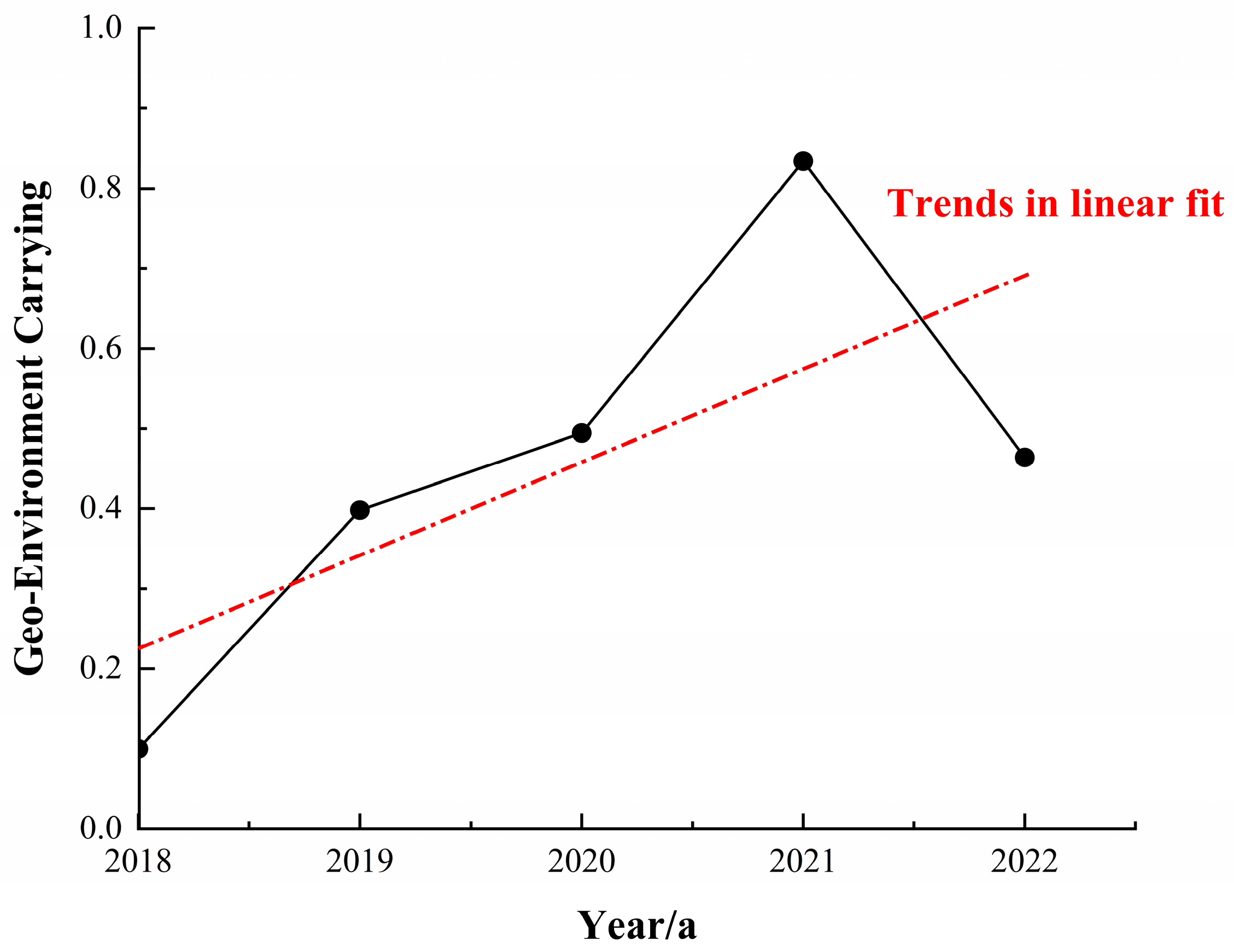
3.1. Comprehensive Calculation of Geoenvironmental Carrying Capacity

In the preceding paragraphs, an evaluation index system was constructed to collect underlying data for assessing the geoenvironment carrying capacity of mineral resource-based cities. The collected data has been standardized, as depicted in Table 3. Using the entropy value method, the importance degree of various indexes has been calculated, as demonstrated in Table 4. Additionally, by integrating the theory of mutation, the mutation level of each index has been determined, facilitating a more thorough evaluation and analysis.

3.2. Evaluation and Analysis of Geoenvironmental Carrying Capacity

In consideration of the principle of complementarity and non-complementarity between the evaluation indicators, dovetail-type mutation models are employed to calculate the mutation level values of the intermediate-level indicators. The mutation level value of each index in the middle layer is calculated using the normalization formula of the dovetail-, shed-, hut-, and swallow-tail-type mutation models, respectively. Table 3 and Table 4 indicate that the relative importance of the indicators can be described in the following order: X1 > X2 > X3; X5 > X4 > X6 > X8 > X7; X10 > X11 > X9 > X12 > X13; X16 > X15 > X14. The comprehensive evaluation value of the geoenvironment carrying capacity in Fushun City is calculated annually according to the indexes in the middle layer, as illustrated in Figure 4. The dot-dash line in the figure represents the trend line for geoenvironment carrying capacity, indicating the general trend observed over the assessment period.
In line with existing research, the assessment of geoenvironmental carrying capacity is categorized into five grades: low, low-medium, medium, medium-high, and high [29]. The standard value of each grade of mine environmental quality is standardized, integrated into the existing evaluation approach, and ultimately yields the standard value for each evaluation grade (refer to Table 5). II. The mutation grade value falls from 0 to 1, with a higher mutation grade implying a greater geoenvironmental carrying capacity.
Between 2018 and 2021, the geoenvironmental carrying capacity of the study area continued to increase, reaching a medium-high rating. This positive trend is reflected in the values obtained from the assessment, which were 0.100, 0.398, and 0.495 for the years 2018, 2019, and 2020, respectively. However, in 2022, the situation deteriorated, with the assessment value dropping to 0.464, indicating a decline to a medium-low rating. This decline can be attributed to the absence of new contingency plans being implemented. There may be delays in upgrading the monitoring and early warning system, which may affect the ability to monitor and warn of the state of the geoenvironment and to detect and warn of potential geoenvironmental problems on time. The dual influence of these factors led to a negative impact on the geoenvironmental carrying capacity of the study area. Despite this setback in 2022, the overall trend shows an increasing pattern in the geoenvironmental carrying capacity over the mentioned years, signifying an overall enhancement in the geoenvironmental conditions of the study area.
In the context of the pressure system’s deterioration, the key to enhancing the geoenvironmental carrying capacity of the region lies in controlling the driving force and elevating the level of the response layer within the DPSR model. The region’s geoenvironmental carrying capacity is principally impacted by the level of the response layer. When considering individual factors, the number of mining activities, the number of newly issued municipal emergency response plans, and the number of significant documents released by the Municipal Emergency Response Office (MERO) emerge as critical determinants affecting the region’s geoenvironmental carrying capacity. The rising trend in geoenvironmental carrying capacity can be attributed to the declining annual mining activities, the escalation in the number of monitoring points, as well as the substantial attention devoted by the MERO.

3.3. Suggestions for Improving Geoenvironmental Carrying Capacity in Fushun

As of 2015, the West Open Pit Mine, the largest pit in Fushun City, had experienced over ninety landslides, prompting the cessation of mining operations at the site. The mine is scheduled to cease operations in 2016, with complete closure expected in 2019. Statistical data dating back to 1927 highlights the historical occurrence of landslides at the mine site. Section 3.1 emphasizes that improving the geoenvironmental carrying capacity of the region hinges on enhancing the response layer, contingent upon controlling both the driving force and pressure. This improvement strategy involves three key elements: first, an increase in the number of monitoring points and the establishment of a comprehensive, three-dimensional geoenvironmental monitoring network; second, the enhancement of early warning and prediction accuracy of geohazards; and third, the establishment of a rapid response mechanism to bolster rescue capabilities and expedite actions across all sectors to mitigate the impact of geohazard-related disasters.

3.4. Performance in Policy

In August 2005, the Liaoning Provincial People’s Government instructed the Liaoning Geology and Mineral Resources Exploration Bureau to establish a monitoring team responsible for conducting monitoring activities, issuing early warnings, and predicting potential disasters. By September of that year, the General Station of Geological and Environmental Surveillance of Liaoning Province had mobilized a professional team to investigate and monitor geological hazards. On 10 June 2006, the monitoring and early warning of geological disasters started at the North Gang of Fushun West Open Pit Mine, supported by the establishment of a professional monitoring network. From June 2006 to December 2016, various systems, including GPS monitoring and groundwater depth monitoring, were implemented, enabling early detection of geological disasters and helping the authorities to develop risk mitigation strategies. In August 2015, the Fushun Development and Reform Commission issued a notice for the “Renewal Project of Geological Environmental Monitoring of Fushun”, transferring responsibility for the North Gang to the General Station, which continues to monitor the area and issue early warnings based on the results.
On 28 September 2018, Xi Jinping, General Secretary of the CPC Central Committee, President of the State Council, and Chairman of the Central Military Commission, visited the Fushun West Open Pit Mine and proposed a comprehensive strategy for managing the environmental impacts of coal mining operations. During this visit, he emphasized the importance of a balanced approach that integrates governance and industrial development. General Secretary Xi Jinping then hosted a symposium in Shenyang City on Northeastern revitalization, where he highlighted the need for a scientific and impartial approach to implementing a comprehensive management strategy for coal mining subsidence areas. He recommended conducting a basic census of coal mining subsidence areas in the northeast and supported the comprehensive management of mega open pits such as the Fuxin Haizhou Mine and the Fushun West Open Pit, aiming to optimize the utilization of this significant resource along with promoting the balanced development of the region.
In 2018, the Liaoning Tenth Geological Brigade Limited Liability Company established a comprehensive deformation monitoring system for the West Pit Mine through the West Pit Mine Comprehensive Deformation Monitoring Network Construction Project. This system comprises the West Pit Mine Comprehensive Monitoring and Early Warning Platform and associated monitoring equipment. Furthermore, the construction of the system and the platform provides an optimal foundation for the integration of the original monitoring system for the south and north gangs. The integration of the various monitoring systems of the West Pit Mine has already been achieved through the uniform incorporation of the monitoring system for the south and north gangs into the West. Furthermore, the monitoring systems of the south and north gangs have been incorporated into the West Pit Mine Comprehensive Deformation Monitoring Network, which is utilized for unified and coordinated management [30].
In June 2019, the Liaoning Provincial Party Committee and the Provincial Government decided to retire the coal and close the West Open Pit Mine, marking the start of the transition from mining to management [31].
In 2020, the Fushun Municipal Government implemented a more comprehensive 2020 Action Plan for the comprehensive management of the West Open Pit Mine. The plan identified six key tasks, including master planning, policy support, and the implementation of 24 key projects with a total investment of CNY 1 billion and an annual investment of CNY 800 million. The West Open Pit Mine also completed the closure and withdrawal acceptance in the same year. The implementation of these policies has further consolidated the achievements of geoenvironmental management in the region.
In 2021, the Fushun Municipal Government continued to promote the comprehensive management of the West Open Pit Mine and formulated a new action plan. The plan includes six key areas of work, with RMB 1.57 billion invested in 23 key projects, including the development of an engineering study on mine safety management. This continued policy support will help further improve the region’s geoenvironmental carrying capacity.
In 2022, the People’s Government of Fushun City issued the implementation of the Fushun Municipal Mineral Resources Master Plan (2021–2025), in which the requirements for the development of the mining industry are as follows: The Fushun Municipal Government will further improve the ability to safeguard mineral resources, promote the green development of the mining industry, improve the exploration and development of innovative mechanisms, enhance the level of development and utilization of mineral resources, and improve the system of mineral resources management. Specific measures include paying attention to the region’s important strategic minerals and advantageous minerals to find and increase reserves and maintain the traditional metallurgy, energy, and building materials category of mineral resources safety bottom line. Adhering to the policy of giving priority to the conservation, protection, and restoration of nature, we will promote green exploration and construction of green mines in large and medium-sized major mines to realize the double guarantee of resource safety and ecological safety. We will strengthen research on mineralization models and methods of finding minerals in the deep and peripheral parts of existing old mines and, at the same time, strengthen research on the exploration, development, and utilization of clean energy and strategic emerging minerals. We will implement the “dual control” management of the total amount of beneficial mineral resources extraction and the minimum amount of access, promote the application of advanced and applicable technologies, and strengthen energy conservation, emission reduction, and comprehensive utilization of solid waste. We will further deepen the reform of “release management and service”, give full play to the decisive role of the market in resource allocation, further optimize the business environment, and improve the institutional mechanism of “release management and service”.

3.5. Limitations and Future Work

This study proposes a comprehensive approach to assess the geoenvironmental carrying capacity of mineral resource cities based on the sustainable development perspective. The integration of the DPSR model, catastrophe theory, entropy method, and analysis hierarchical process forms the basis for making suggestions. However, it is essential to acknowledge the limitations associated with this approach. One limitation is the variability in geoenvironmental characteristics and sustainable development goals among different mineral resource cities, like Fushun City, which is primarily a coal mining resource city. Another challenge lies in quantifying important qualitative indicators, such as the strength of policy implementation and public awareness of environmental protection, when establishing the evaluation index system. The inability to directly quantify these indicators may underestimate their significance in the evaluation process. To address this issue, conducting relevant quantitative studies to explore effective quantification methods for qualitative indicators is recommended. By doing so, a more accurate assessment of the role of these indicators in geoenvironmental carrying capacity can be achieved. The study findings highlight the substantial impact of mining engineering activities and the level of response on the evaluation outcomes. Moving forward, research focusing on the interplay among the urban living environment, production environment, and geological environment is identified as the next research direction.
In the future, research into more environmentally friendly and sustainable extraction methods for mineral resources is extremely important. Developing techniques to recover rare earth elements from coal and coal byproducts could provide a more sustainable source [32]. Adopting selective mining and processing methods, integrating renewable energy in operations, minimizing waste through recycling and reuse, and implementing ecological restoration and land reclamation practices can all help reduce the environmental footprint of mineral extraction [33,34]. Collaborative research and development between industry, academia, and government will be crucial to drive innovation in sustainable mining technologies and practices. By pursuing these and other eco-friendly approaches, the mineral resources sector can work towards a future that balances economic needs with environmental protection.

4. Conclusions

This study constructs a set of index systems that can be applied to evaluate the geoenvironmental carrying capacity of mineral resource-based cities. Sixteen indicators, such as mining volume, are selected from the perspective of sustainable development. The study utilizes methods such as mutation theory, entropy method, AHP, and other techniques to determine the geoenvironmental carrying capacity based on the DPSR model. The findings are categorized into five grades: low, medium-low, medium, medium-high, and high. The analysis focuses on the trend of geoenvironmental carrying capacity in Fushun City from 2018 to 2022, alongside an investigation into the region’s driving factors influencing the geoenvironmental carrying capacity. Recommendations for the sustainable development of the geoenvironment are provided. In conclusion, the study offers insights into the evaluation of geoenvironmental carrying capacity in mineral resource-based cities.
(1) The evaluation index system of mineral resource-based cities is constructed based on the driving forces–pressure–state–response (DPSR) model within the sustainable development framework. This system integrates mutation theory, entropy value method, and analysis hierarchical process to effectively address the intricate relationships among resources, economy, and geoenvironment. By doing so, the system can mitigate subjectivity in the evaluation process, unveil the underlying causes of geoenvironmental carrying capacity, and exhibit enhanced suitability for mineral resource-based cities aspiring towards sustainable development. This approach holds great significance in safeguarding public safety, geological resources, and sustainable economic development.
(2) In Fushun City, the geoenvironmental carrying capacity has exhibited a consistent upward trajectory, indicating an overall improvement in the geoenvironmental conditions within the region. This positive trend can be attributed to the annual reduction in mining activities, the expansion of monitoring networks, and the heightened vigilance demonstrated by the city’s emergency response office.
(3) The level of the response emerges as the primary driver influencing the geoenvironmental carrying capacity of the region. Factors such as mining volume, the issuance of new municipal-level emergency plans, and the release of crucial documents by the municipal emergency response office play pivotal roles in shaping the geoenvironmental carrying capacity. Mineral resource-based cities are urged to establish prompt response mechanisms, fortify monitoring and early warning systems, and adopt sustainable development practices aligned with the life cycle of mineral resources.

Author Contributions

Conceptualization, J.L., Z.M. and C.G.; methodology, J.L. and Y.W.; investigation, Z.M., Y.W. and X.W.; resources, F.C.; writing—original draft preparation, J.L.; writing—review and editing, J.L. and G.L.; supervision, G.L.; project administration, G.L. All authors have read and agreed to the published version of the manuscript.

Funding

This work was supported by the Fushun West Open-Pit Mine Deformation Monitoring System Operation Project (Grant numbers [JH23-210000-06419/0614SY230156]).

Institutional Review Board Statement

Not applicable.

Informed Consent Statement

Not applicable.

Data Availability Statement

The data presented in this study are available on request from the corresponding author.

Conflicts of Interest

Author Fengchuan Chen was employed by the Liaoning Tenth Geological Brigade Limited Liability Company. The remaining authors declare that the research was conducted in the absence of any commercial or financial relationships that could be construed as a potential conflict of interest.

References

  1. Doyle, P. ENVIRONMENTAL GEOLOGY. In Encyclopedia of Geology; Selley, R.C., Cocks, L.R.M., Plimer, I.R., Eds.; Elsevier: Oxford, UK, 2005; pp. 25–33. ISBN 978-0-12-369396-9. [Google Scholar]
  2. Yang, C.; Zeng, W.; Yang, X. Coupling Coordination Evaluation and Sustainable Development Pattern of Geo-Ecological Environment and Urbanization in Chongqing Municipality, China. Sustain. Cities Soc. 2020, 61, 102271. [Google Scholar] [CrossRef]
  3. Shen, L.; Shu, T.; Liao, X.; Yang, N.; Ren, Y.; Zhu, M.; Cheng, G.; Wang, J. A New Method to Evaluate Urban Resources Environment Carrying Capacity from the Load-and-Carrier Perspective. Resour. Conserv. Recycl. 2020, 154, 104616. [Google Scholar] [CrossRef]
  4. Wang, J.; Huang, Y.; Li, J. Resource and Environmental Carrying Capacity Study of Kubai Coalfield in Xinjiang Based on RS and GIS. J. Clean. Prod. 2024, 450, 141977. [Google Scholar] [CrossRef]
  5. Yang, Z.; Li, W.; Li, X.; Wang, Q.; He, J. Assessment of Eco-Geo-Environment Quality Using Multivariate Data: A Case Study in a Coal Mining Area of Western China. Ecol. Indic. 2019, 107, 105651. [Google Scholar] [CrossRef]
  6. Li, H.; Long, R.; Chen, H. Economic Transition Policies in Chinese Resource-Based Cities: An Overview of Government Efforts. Energy Policy 2013, 55, 251–260. [Google Scholar] [CrossRef]
  7. Wu, Q.; Liu, S. The Classification of Mine Environmental Geology Problems in China. Environ. Earth Sci. 2011, 64, 1505–1511. [Google Scholar] [CrossRef]
  8. Ruan, F.; Yan, L.; Wang, D. The Complexity for the Resource-Based Cities in China on Creating Sustainable Development. Cities 2020, 97, 102571. [Google Scholar] [CrossRef]
  9. Fatehi, M.; Asadi, H.H.; Hossein Morshedy, A. 3D Design of Optimum Complementary Boreholes by Integrated Analysis of Various Exploratory Data Using a Sequential-MADM Approach. Nat. Resour. Res. 2020, 29, 1041–1061. [Google Scholar] [CrossRef]
  10. Esmaeiloghli, S.; Tabatabaei, S.H.; Carranza, E.J.M. Spatio-Geologically Informed Fuzzy Classification: An Innovative Method for Recognition of Mineralization-Related Patterns by Integration of Elemental, 3D Spatial, and Geological Information. Nat. Resour. Res. 2021, 30, 989–1010. [Google Scholar] [CrossRef]
  11. Sonker, I.; Tripathi, J.N.; Singh, A.K. Landslide Susceptibility Zonation Using Geospatial Technique and Analytical Hierarchy Process in Sikkim Himalaya. Quat. Sci. Adv. 2021, 4, 100039. [Google Scholar] [CrossRef]
  12. Wang, L.; Liu, H. Comprehensive Evaluation of Regional Resources and Environmental Carrying Capacity Using a PS-DR-DP Theoretical Model. J. Geogr. Sci. 2019, 29, 363–376. [Google Scholar] [CrossRef]
  13. Dun, L.; Xie, W. Research Progress and Prospect of Urban Geological Environment Carrying Capacity. J. Inst. Disaster Prev. 2018, 20, 15–20. [Google Scholar]
  14. Li, R.; Yin, Z.; Wang, Y.; Li, X.; Liu, Q.; Gao, M. Geological Resources and Environmental Carrying Capacity Evaluation Review, Theory, and Practice in China. China Geol. 2018, 1, 556–565. [Google Scholar] [CrossRef]
  15. Xi, X.; Wang, S.; Yao, L.; Zhang, Y.; Niu, R.; Zhou, Y. Evaluation on Geological Environment Carrying Capacity of Mining City—A Case Study in Huangshi City, Hubei Province, China. Int. J. Appl. Earth Obs. 2021, 102, 102410. [Google Scholar] [CrossRef]
  16. Wu, C.; Zhang, Y.; Zhang, J.; Chen, Y.; Duan, C.; Qi, J.; Cheng, Z.; Pan, Z. Comprehensive Evaluation of the Eco-Geological Environment in the Concentrated Mining Area of Mineral Resources. Sustainability 2022, 14, 6808. [Google Scholar] [CrossRef]
  17. Qi, J.; Zhang, Y.; Zhang, J.; Chen, Y.; Wu, C.; Duan, C.; Cheng, Z.; Pan, Z. Research on the Evaluation of Geological Environment Carrying Capacity Based on the AHP-CRITIC Empowerment Method. Land 2022, 11, 1196. [Google Scholar] [CrossRef]
  18. Wang, Y.; Yuan, M.; Zhou, X.; Qu, X. Evaluation of Geo-Environment Carrying Capacity Based on Intuitionistic Fuzzy TOPSIS Method: A Case Study of China. Sustainability 2023, 15, 8121. [Google Scholar] [CrossRef]
  19. Yao, Z.; Wang, H.; Hang, X. Evaluation of Geological Environment Carrying Capacity Based on Set Pair Analysis: A Case Study in Daqing. Environ. Sci. Technol. 2010, 33, 183–189. [Google Scholar]
  20. Zhou, Y.; Bi, T.; Yu, M.; Gong, C. Multi-perspective evaluation of city sustainability and configuration analysis based on fsQCA method: A case study of Liaoning Province, China. Environ. Dev. Sustain. 2024. [Google Scholar] [CrossRef]
  21. Zhang, F.; Yang, T.; Li, L.; Bu, J.; Wang, T.; Xiao, P. Assessment of the rock slope stability of Fushun West Open-pit Mine. Arab. J. Geosci. 2021, 14, 1459. [Google Scholar] [CrossRef]
  22. Sun, S.-W.; Liu, L.; Hu, J.-B.; Ding, H. Failure characteristics and mechanism of a rain-triggered landslide in the northern longwall of Fushun west open pit, China. Landslides 2022, 19, 2439–2458. [Google Scholar] [CrossRef]
  23. Sun, C.; Jin, C.; Wang, L.; Cai, J.; Li, J. Creep damage characteristics and slip law of weak-layer mudstone in an open mining slope. Bull. Eng. Geol. Environ. 2023, 82, 399. [Google Scholar] [CrossRef]
  24. Li, Y.; Zhang, L.; Wu, B.; Li, L.; Zhang, Y. Spatial response relationship between mining and industrial activities and eco-environmental risks in mineral resource–based areas. Environ. Sci. Pollut. Res. 2023, 30, 84765–84777. [Google Scholar] [CrossRef] [PubMed]
  25. Thom, R. Structural Stability and Morphogenesis: An Outline of a General Theory of Models; CRC Press: Boca Raton, FL, USA, 2018; ISBN 978-0-201-40685-6. [Google Scholar]
  26. Kennedy, R.E.; Yang, Z.; Gorelick, N.; Braaten, J.; Cavalcante, L.; Cohen, W.B.; Healey, S. Implementation of the LandTrendr Algorithm on Google Earth Engine. Remote Sens. 2018, 10, 691. [Google Scholar] [CrossRef]
  27. Mi, X.; Cao, Q.; Li, D.; Wang, J. The Evaluation of Coal Mine Safety Based on Entropy Method and Mutation Theory. IOP Conf. Ser. Earth Environ. Sci. 2021, 769, 032023. [Google Scholar] [CrossRef]
  28. Wang, Z.; Wang, Y.; Wang, L.; Zhang, T.; Tang, Z. Research on the comprehensive evaluation system of eco-geological environmental carrying capacity based on the analytic hierarchy process. Clust. Comput. 2019, 22 (Suppl. S3), 5347–5356. [Google Scholar] [CrossRef]
  29. Wang, X.; Li, S.; Sun, Y.; Li, X.; Wen, L. Evaluation on quality of mine environment based on entropy value method and catastrophe theory. Coal Sci. Technol. 2018, 46, 264–267. [Google Scholar]
  30. Notice on the Publication and Implementation of Liaoning Provincial Mineral Resources Master Plan (2021–2025). Available online: https://zrzy.ln.gov.cn/zrzy/zfxxgk/fdzdgknr/ghxx/kczygh/87FCF6CFE2DD4A5292A3186D764A16A8/ (accessed on 28 May 2024).
  31. Li Xiaoan: Do a Good Job of Fushun West Open Pit Mine Integration and Utilization of the Big Article. Available online: https://epaper.lnd.com.cn/lnrbepaper/pad/con/202005/26/content_72646.html (accessed on 28 May 2024).
  32. Kumar Srivastava, M.; Kishor, K.; Singh, A.K. A comprehensive petrochemical study of coals of Jaintia Hills: Unveiling their industrial applicability and potential as hydrocarbon source rocks. Int. J. Coal Prep. Util. 2024, 1–15. [Google Scholar] [CrossRef]
  33. Modi, P.; Hower, J.C.; Giri, R.K.; Rahi, I.C.; Siddiqui, M.A.; Rajak, P.K.; Jamal, A. Recovery of rare earth elements from coal samples from the Sohagpur coalfield, Madhya Pradesh, India. Int. J. Coal Prep. Util. 2023, 44, 219–239. [Google Scholar] [CrossRef]
  34. Shirin, S.; Jamal, A.; Emmanouil, C.; Singh, V.P.; Yadav, A.K. Assessment and characterization of waste material used as backfilling in an abandoned mine. Int. J. Coal Prep. Util. 2022, 43, 1402–1410. [Google Scholar] [CrossRef]
Figure 1. Location of the study area.
Sustainability 16 07934 g001
Figure 2. Flow chart of geoenvironment carrying capacity in mineral resource-based cities.
Sustainability 16 07934 g002
Figure 3. Hierarchical structure of evaluation indicators selection.
Sustainability 16 07934 g003
Figure 4. Temporal variation of geological environment carrying capacity, 2018–2022.
Sustainability 16 07934 g004
Table 1. Catastrophe progression model.
Catastrophic ModelControl VariableState VariablePotential Function
Folding type11 x3 + ax
Pointed type2 1x4 + ax2 + bx
Dovetail type31x5 + ax3 + bx2 + cx
Butterfly type41x6 + ax4 + bx3 + cx2 + dx
Shed type5 1x7 + ax5 + bx4 + cx3 + dx2 + ex
Table 2. Data sources.
CodeIndicatorData Source
X1Mining volumeFushun City Bureau of Statistics (https://fstjj.fushun.gov.cn/, accessed on 1 December 2023)
X2Annual RainfallFushun City Bureau of Statistics (https://fstjj.fushun.gov.cn/, accessed on 1 December 2023)
X3Underground water resourcesFushun City Bureau of Statistics (https://fstjj.fushun.gov.cn/, accessed on 1 December 2023)
X4Vehicle OwnershipFushun City Bureau of Statistics (https://fstjj.fushun.gov.cn/, accessed on 1 December 2023)
X5Share of secondary industry outputFushun City Bureau of Statistics (https://fstjj.fushun.gov.cn/, accessed on 1 December 2023)
X6Population DensityWorldPop (https://www.worldpop.org/, accessed on 19 March 2024)
X7Road areahttps://www.webmap.cn/, accessed on 19 March 2024
X8GDP per capitaFushun City Bureau of Statistics (https://fstjj.fushun.gov.cn/, accessed on 1 December 2023)
X9Maximum Horizontal Displacement of SlopeField Scientific Observation and Research Station for Landslide Disaster in Fushun Open Pit Mine, Liaoning, Ministry of Natural Resources of China
X10Maximum Vertical Displacement of SlopeField Scientific Observation and Research Station for Landslide Disaster in Fushun Open Pit Mine, Liaoning, Ministry of Natural Resources of China
X11Average deformation rate of ground in deformation areaField Scientific Observation and Research Station for Landslide Disaster in Fushun Open Pit Mine, Liaoning, Ministry of Natural Resources of China
X12Relative Displacement of Ground CracksField Scientific Observation and Research Station for Landslide Disaster in Fushun Open Pit Mine, Liaoning, Ministry of Natural Resources of China
X13Maximum ground settlementField Scientific Observation and Research Station for Landslide Disaster in Fushun Open Pit Mine, Liaoning, Ministry of Natural Resources of China
X14Number of monitoring pointsLiaoning Tenth Geological Brigade Limited Liability Company Geological and Environmental Monitoring Institute
X15Number of new emergency plans issued by the municipal levelFushun Geological Disaster Emergency Response Technical Guidance Center
X16Number of important documents issued by the Municipal Emergency Response OfficeFushun Geological Disaster Emergency Response Technical Guidance Center
Table 3. Data sources standardization.
Year20182019202020212022
X10.000.020.110.911.00
X21.000.850.520.000.09
X30.581.000.880.450.00
X40.001.000.590.200.22
X50.000.060.571.000.86
X60.000.190.400.851.00
X71.000.960.890.870.00
X80.520.001.000.710.38
X90.000.260.330.971.00
X100.521.000.200.000.09
X111.000.710.280.190.00
X120.000.280.881.000.97
X130.601.000.000.600.70
X140.000.480.481.001.00
X150.001.000.001.000.00
Table 4. Combined weights.
Bottom WeightMiddle WeightCombined Weights
X10.5030.2000.101
X20.3040.061
X30.1930.039
X40.2440.2550.062
X50.2530.065
X60.2160.055
X70.1260.032
X80.1610.041
X90.2330.2330.054
X100.3250.076
X110.2520.059
X120.1900.044
X130.1530.036
X140.1320.3120.041
X150.4210.131
X160.4470.139
Table 5. Grading standards.
HierarchyVIVIIIIII
Grading Value[0, 0.1)[−0.1, 0.3)[0.3, 0.6)[0.6, 0.8)[0.8, 1.0)
Standard value[0, 0.316)[0.316, 0.548)[0.548, 0.775)[0.775, 0.894)[0.894, 1.0)
Resultlowlow-mediummediummedium-highhigh
Disclaimer/Publisher’s Note: The statements, opinions and data contained in all publications are solely those of the individual author(s) and contributor(s) and not of MDPI and/or the editor(s). MDPI and/or the editor(s) disclaim responsibility for any injury to people or property resulting from any ideas, methods, instructions or products referred to in the content.

